A Case Study for an Assessment of Fire Station Selection in the Central Urban Area
Abstract
1. Introduction
2. Research Objects and Methods
2.1. Research Objects
2.2. Research Methods
2.2.1. Set Covering Model
2.2.2. Maximum Coverage Model
2.2.3. P-Center Model
2.2.4. Calculation of the Area of Fire Station Jurisdiction
3. Results
3.1. Set Constraints
- (1)
- Response time
- (2)
- Road capacity
- (3)
- Natural terrain
- (4)
- Economic development
3.2. Building-UpA a Firefighting Traffic Network Model
4. Discussion
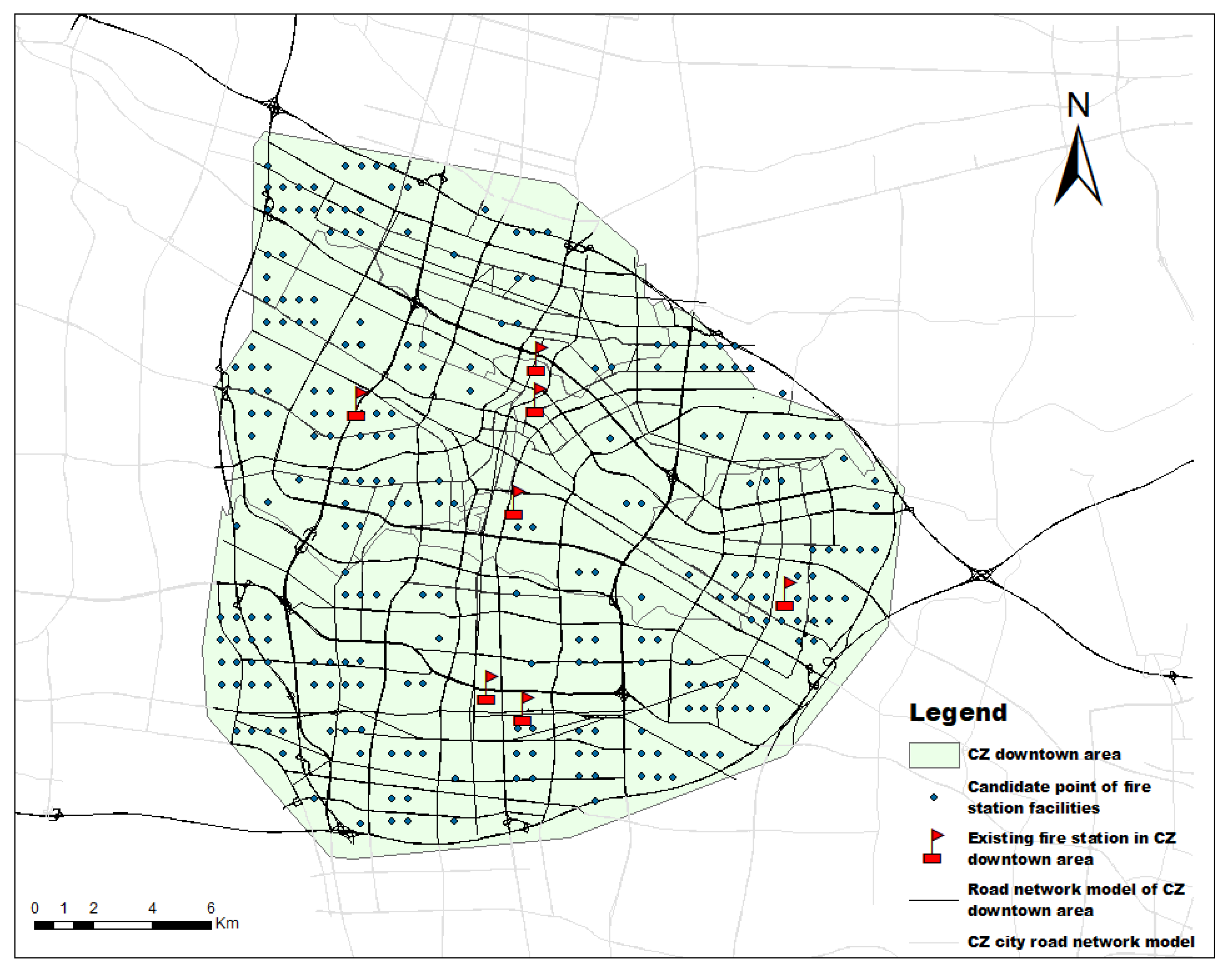
4.1. Preliminary Optimization of Fire Station Layout
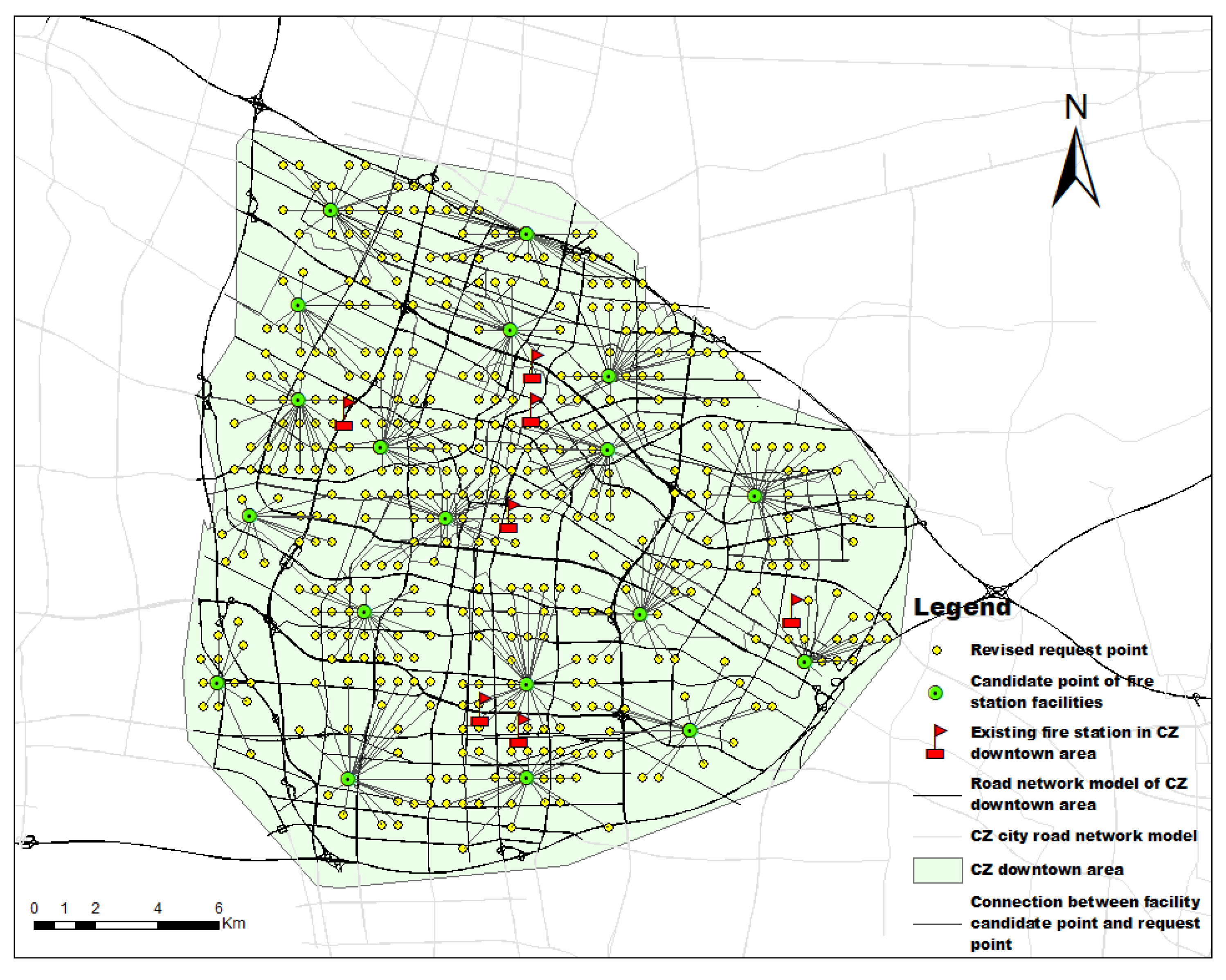
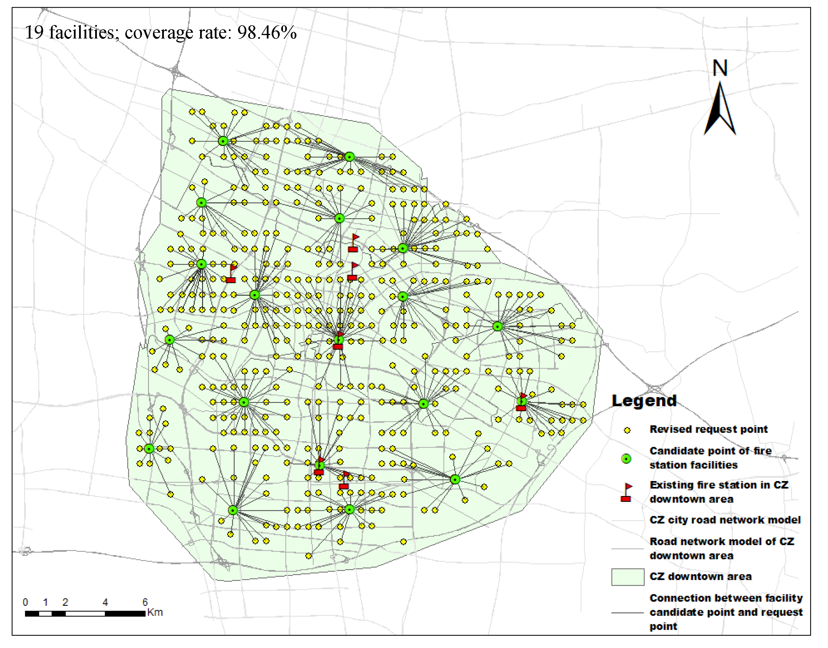
4.2. Enhanced Optimization Utilizing Revised Demand Points
5. Conclusions
Author Contributions
Funding
Data Availability Statement
Acknowledgments
Conflicts of Interest
Nomenclature
| A | Fire station area |
| Minimum distance between demand point and candidate facility point | |
| D | Maximum allowable distance between the demand point and the facility |
| ha | Hectare |
| i | A demand point |
| I | A collection of all demand points |
| j | A candidate facility point |
| J | A set of candidate facilities |
| p | Straight-line distance from the fire station to the farthest point |
| S | Actual distance from the fire station to the farthest point on the edge |
| Demand point that is served by the candidate facility | |
| Service capacity of the candidate facility | |
| λ | Curve coefficient of the route |
References
- Li, G.; Zhang, J.; Liu, S. Determination of urban emergency logistics demand area and classification method. China Saf. Sci. J. 2012, 22, 157–164. [Google Scholar] [CrossRef]
- Liu, D.; Xu, Z.; Yan, L.; Fan, C. Dynamic estimation system for fire station service areas based on travel time data. Fire Saf. J. 2020, 118, 103238. [Google Scholar] [CrossRef]
- Bilham, R. Disaster management: Preparing for the worst. Nature 2013, 205, 438. [Google Scholar] [CrossRef][Green Version]
- Nisanci, R. GIS based fire analysis and production of fire-risk maps: The Trabzon experience. Sci. Res. Essays 2010, 5, 970–977. [Google Scholar]
- Yao, J.; Zhang, X.; Murray, A.T. Location optimization of urban fire stations: Access and service coverage. Comput. Environ. Urban Syst. 2019, 73, 184–190. [Google Scholar] [CrossRef]
- Nyimbili, P.H.; Erden, T. GIS-based fuzzy multi-criteria approach for optimal site selection of fire stations in Istanbul, Turkey. Socio-Econ. Plan. Sci. 2020, 71, 100860. [Google Scholar] [CrossRef]
- Oliveira, M.; Slezakova, K.; Alves, M.J.; Fernandes, A.; Teixeira, J.P.; Delerue-Matos, C.; Pereira, M.D.C.; Morais, S. Polycyclic aromatic hydrocarbons at fire stations: Firefighters’ exposure monitoring and biomonitoring, and assessment of the contribution to total internal dose. J. Hazard. Mater. 2017, 323, 184–194. [Google Scholar] [CrossRef]
- Marcus, R. Measuring the Capabilities of the Swedish Fire Service to Save Lives in Residential Fires. Fire Technol. 2020, 56, 583–603. [Google Scholar]
- Casartelli, V.; Mysiak, J. European Union Civil Protection—Peer Review Programme for Disaster Risk Management: Wildfire Peer Review Assessment Framework (Wildfire PRAF); European Comission: Brussels, Belgium, 2023. [Google Scholar]
- Wright, J.; Liu, J.; Bain, R.; Perez, A.; Crocker, J.; Bartram, J.; Gundry, S. Water quality laboratories in Colombia: A GIS-based study of urban and rural accessibility. Sci. Total Environ. 2014, 485, 643–652. [Google Scholar] [CrossRef]
- Li, D.; Cova, T.J.; Dennison, P.E. Setting Wildfire Evacuation Triggers by Coupling Fire and Traffic Simulation Models: A Spatiotemporal GIS Approach. Fire Technol. 2019, 55, 617–642. [Google Scholar] [CrossRef]
- Deng, Y.; Li, A.; Dou, W. Comparative analysis of urban fire station layout planning models. J. Geo-Inf. Sci. 2008, 10, 242–246. [Google Scholar]
- Bai, H.; Wu, Y. Study on Layout Optimization of fire stations in old urban areas. China Saf. Sci. J. 2010, 81–87. Available online: http://www.cssjj.com.cn/CN/Y2010/V20/I8/81 (accessed on 17 October 2023).
- NFPA 1710; Standard for the Organization and Deployment of Fire Suppression Operations, Emergency Medical Operations, and Special Operations to the Public by Volunteer Fire Departments. National Fire Protection Association: Boston, MA, USA, 2001.
- Yang, L.; Jones, B.F.; Yang, S. A fuzzy multi-objective programming for optimization of fire station locations through genetic algorithms. Eur. J. Oper. Res. 2006, 181, 903–915. [Google Scholar] [CrossRef]
- Chaudhary, P.; Chhetri, S.K.; Joshi, K.M.; Shrestha, B.M.; Kayastha, P. Application of an Analytic Hierarchy Process (AHP) in the GIS interface for suitable fire site selection: A case study from Kathmandu Metropolitan City, Nepal. Socio-Econ. Plan. Sci. 2016, 53, 60–71. [Google Scholar] [CrossRef]
- Liu, Y.C.; Jiang, J.C.; Huang, A.C. Experimental study on extinguishing oil fire by water mist with polymer composite additives. J. Therm. Anal. Calorim. 2023, 148, 4811–4822. [Google Scholar] [CrossRef]
- Liu, L.; Chen, C. An optimal layout of fire area based on GIS and set coverage method. Sci. Surv. Mapp. 2018, 43, 46–51. [Google Scholar] [CrossRef]
- Davoodi, M.; Mesgari, M.S. A GIS based Fire Station Site Selection using Network Analysis and Set Covering Location Problem. Int. J. Hum. Geogr. Environ. Stud. 2018, 433–436. [Google Scholar] [CrossRef]
- Lin, J.; Jiang, X.; Zhu, J.; Cao, W.; Kong, Y. Application of GIS model in urban fire station layout planning. City Plann. Rev. 2018, 5, 63–68. [Google Scholar]
- Austin, A.; Ezekoye, O.A. Quantifying Generalized Residential Fire Risk Using Ensemble Fire Models with Survey and Physical Data. Fire Technol. 2018, 54, 715–747. [Google Scholar]
- Xu, Z.; Zhou, L.; Lan, T.; Wang, Z.; Sun, L.; Wu, R. Spatial optimization of mega city fire station based on POI data—Taking the area within the Fifth Ring Road of Beijing as an example. Prog. Geogr. 2018, 37, 535–546. [Google Scholar]
- Shahparvari, S.; Fadaki, M.; Chhetri, P. Spatial accessibility of fire stations for enhancing operational response in Melbourne. Fire Saf. J. 2020, 117, 103149. [Google Scholar] [CrossRef]
- Hu, J.; Shu, X.; Xie, S.; Tang, S.; Wu, J.; Deng, B. Socioeconomic determinants of urban fire risk: A city-wide analysis of 283 Chinese cities from 2013 to 2016. Fire Saf. J. 2019, 110, 102890. [Google Scholar] [CrossRef]
- Ahumada, C.B.; Noor, Q.; Sam, M.M. A method for facility layout optimisation including stochastic risk assessment. Process Saf. Environ. Prot. 2018, 117, 616–628. [Google Scholar] [CrossRef]
- Heyns, A.M.; Plessis, W.D.; Curtin, K.M.; Kosch, M.; Hough, G. Analysis and Exploitation of Landforms for Improved Optimisation of Camera-Based Wildfire Detection Systems. Fire Technol. 2021, 57, 2269–2303. [Google Scholar] [CrossRef]
- Rahman, M.; Chen, N.; Islam, M.M.; Dewan, A.; Pourghasemi, H.R.; Washakh, R.M.A.; Nepal, N.; Tian, S.; Faiz, H.; Alam, M.; et al. Location-allocation modeling for emergency evacuation planning with GIS and remote sensing: A case study of Northeast Bangladesh. Geosci. Front. 2021, 12, 101095. [Google Scholar] [CrossRef]
- Burkard, R.E.; Pleschiutschnig, C.; Zhang, J. Inverse median problems. Discret. Optim. 2004, 1, 23–39. [Google Scholar] [CrossRef]
- Song, Z.; Yan, T.; Liu, T.; Huang, T. New gravity P median model and its empirical test in the location decision of urban general hospitals—A case study of Wuxi City. Prog. Geogr. 2016, 35, 420–430. [Google Scholar]
- Sadovnychiy, S. Gabor Features Extraction and Land-Cover Classification of Urban Hyperspectral Images for Remote Sensing Applications. Remote Sens. 2021, 13, 2914. [Google Scholar]
- Liu, B.; Yu, W.K.; Dai, W.J.; Xing, X.M.; Kuang, C.L. Estimation of TerrestrialWater Storage Variations in Sichuan-Yunnan Region from GPS Observations Using Independent Component Analysis. Remote Sens. 2022, 14, 282. [Google Scholar] [CrossRef]
- Qin, K.; He, Q.; Zhang, Y.S.; Cohen, J.B.; Tiwari, P.; Lolli, S. Aloft Transport of Haze Aerosols to Xuzhou, Eastern China: Optical Properties, Sources, Type, and Components. Remote Sens. 2022, 14, 1589. [Google Scholar] [CrossRef]
- Murray, A.T. Optimising the spatial location of urban fire stations. Fire Saf. J. 2013, 62, 64–71. [Google Scholar] [CrossRef]
- Bao, S.; Xiao, N.; Lai, Z.; Zhang, H.; Kim, C. Optimizing watchtower locations for forest fire monitoring using location models. Fire Saf. J. 2015, 71, 100–109. [Google Scholar] [CrossRef]
- Ding, X.; You, J.; Wang, H. Model and optimization algorithm of emergency facility location problem. J. Tongji Univ. (Nat. Sci.) 2012, 40, 1428–1433. [Google Scholar]
- Zhou, H.L.; Jiang, J.C.; Huang, A.C. Thermal hazard assessment of tert-butyl perbenzoate using advanced calorimetric techniques and thermokinetic methods. J. Loss Prev. Process Ind. 2023, 85, 105166. [Google Scholar] [CrossRef]
- Wei, L.; Li, H.; Liu, Q.; Chen, J.; Cui, Y. Fire station planning based on GIS and AHP. Fire Sci. Technol. 2010, 29, 827–831. [Google Scholar]
- Zhang, G. Urban fire risk assessment and application based on spatial analysis—A case study of Xi’an. City Plann. Rev. 2016, 40, 59–64. [Google Scholar]
- Number [2017]75; National Development and Reform Commission of the People’s Republic of China; Revision of Urban FIRE station Construction Standard (Construction Standard); Ministry of Housing and Urban Rural Development of the People’s Republic of China. China Planning Press: Beijing, China, 2017; p. 75.
- Shi, Y.; You, W. Optimization of layout planning of a regional fire station in Xiamen. J. Saf. Sci. Technol. 2013, 10, 152–156. [Google Scholar]
- Nishino, T.; Tanaka, T.; Hokugo, A. An evaluation method for the urban post-earthquake fire risk considering multiple scenarios of fire spread and evacuation. Fire Saf. J. 2012, 54, 167–180. [Google Scholar] [CrossRef]
- Qu, C.; Wang, J.; Huang, J.; He, M. Study on dynamic distribution optimization of post earthquake emergency materials considering timeliness and fairness. Chin. J. Manag. Sci. 2018, 26, 178–187. [Google Scholar]
- Wu, Z.H.; Wu, Y.; Tang, Y.; Jiang, J.C.; Huang, A.C. Evaluation of composite flame-retardant electrolyte additives improvement on the safety performance of lithium-ion batteries. Process Saf. Environ. Prot. 2023, 169, 285–292. [Google Scholar] [CrossRef]
- Ceyhan, E.; Ertuğay, K.; Düzgün, Ş. Exploratory and inferential methods for spatio-temporal analysis of residential fire clustering in urban areas. Fire Saf. J. 2013, 58, 226–239. [Google Scholar] [CrossRef]
- Chen, Z.; Li, J.; Lu, F.; Li, Q. Optimization of site selection and layout of urban fire stations and Its enlightenment to Xiong’an new area. J. Saf. Sci. Technol. 2018, 14, 14–19. [Google Scholar]
- Prampolini, M.; Angeletti, L.; Castellan, G.; Grande, V.; Bas, T.L.; Taviani, M.; Foglini, F. Benthic Habitat Map of the Southern Adriatic Sea (Mediterranean Sea) from Object-Based Image Analysis of Multi-Source Acoustic Backscatter Data. Remote Sens. 2021, 13, 2913. [Google Scholar] [CrossRef]


| Name | Scope of Application | Characteristic |
|---|---|---|
| P-median model | Public sector | Optimize overall or average performance to minimize total transportation costs |
| P-center model | Emergency facilities, public sector | Optimize the worst case to minimize the maximum distance from each demand point to the nearest facility |
| Set covering model | Emergency facilities, public sector | The scope of service covers as many demand points as possible while minimizing the number of facilities |
| Maximum coverage model | Emergency facilities, public sector | The scope of service covers as many demand points as possible |
| Inverse median model | NIMBY (Not in My Back Yard) facilities | Maximize the total weighted distance between the facility and the demand point, as opposed to the P-median model |
| Anti-center model | NIMBY facilities | Maximize the minimum distance between the service facility and the demand point, which is the opposite of the P-center problem |
| Category | Essential | Factor Content |
|---|---|---|
| Spot | Firefighting facilities | Existing fire station |
| Hazard sources | Hazardous chemicals unit | |
| Key units of fire safety | ||
| Line | Route | Main roads in central urban area |
| Surface | Region | Downtown area |
| Road Names | Design Speed of Road (km/h) | Set Speed of Fire Engines (km/h) |
|---|---|---|
| National highway or expressway | 80 | 80 |
| Primary road | 60 | 50 |
| Secondary trunk road | 40 | 40 |
| Branch road | 30 | 30 |
| Jurisdiction Number | Area of Responsibility (km2) |
|---|---|
| ① | 8.60 |
| ② | 14.51 |
| ③ | 8.71 |
| ④ | 9.68 |
| ⑤ | 10.70 |
| ⑥ | 8.60 |
| ⑦ | 12.43 |
| ⑧ | 14.01 |
| ⑨ | 14.51 |
| ⑩ | 12.63 |
| ⑪ | 6.62 |
| ⑫ | 8.50 |
| ⑬ | 12.63 |
| ⑭ | 6.82 |
| ⑮ | 8.93 |
| ⑯ | 5.73 |
| ⑰ | 10.95 |
| ⑱ | 8.65 |
| ⑲ | 14.29 |
Disclaimer/Publisher’s Note: The statements, opinions and data contained in all publications are solely those of the individual author(s) and contributor(s) and not of MDPI and/or the editor(s). MDPI and/or the editor(s) disclaim responsibility for any injury to people or property resulting from any ideas, methods, instructions or products referred to in the content. |
© 2023 by the authors. Licensee MDPI, Basel, Switzerland. This article is an open access article distributed under the terms and conditions of the Creative Commons Attribution (CC BY) license (https://creativecommons.org/licenses/by/4.0/).
Share and Cite
Huang, A.-C.; Huang, C.-F.; Shu, C.-M. A Case Study for an Assessment of Fire Station Selection in the Central Urban Area. Safety 2023, 9, 84. https://doi.org/10.3390/safety9040084
Huang A-C, Huang C-F, Shu C-M. A Case Study for an Assessment of Fire Station Selection in the Central Urban Area. Safety. 2023; 9(4):84. https://doi.org/10.3390/safety9040084
Chicago/Turabian StyleHuang, An-Chi, Chung-Fu Huang, and Chi-Min Shu. 2023. "A Case Study for an Assessment of Fire Station Selection in the Central Urban Area" Safety 9, no. 4: 84. https://doi.org/10.3390/safety9040084
APA StyleHuang, A.-C., Huang, C.-F., & Shu, C.-M. (2023). A Case Study for an Assessment of Fire Station Selection in the Central Urban Area. Safety, 9(4), 84. https://doi.org/10.3390/safety9040084


