Satellite-Based Reconstruction of the Volcanic Deposits during the December 2015 Etna Eruption


Abstract
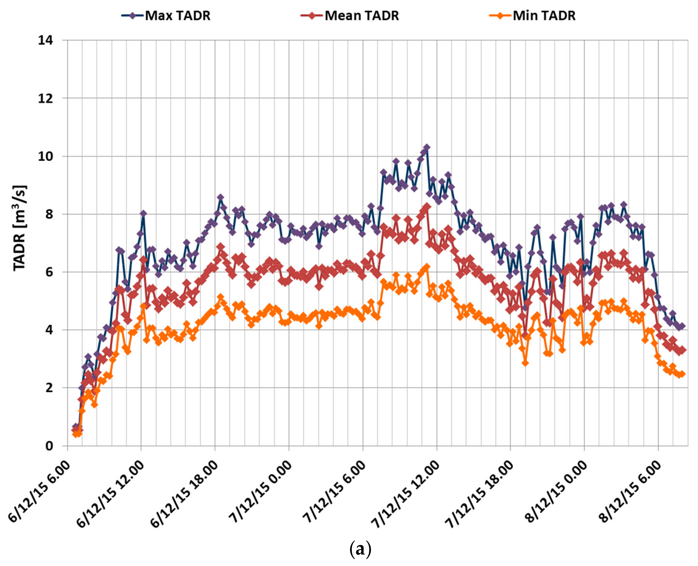
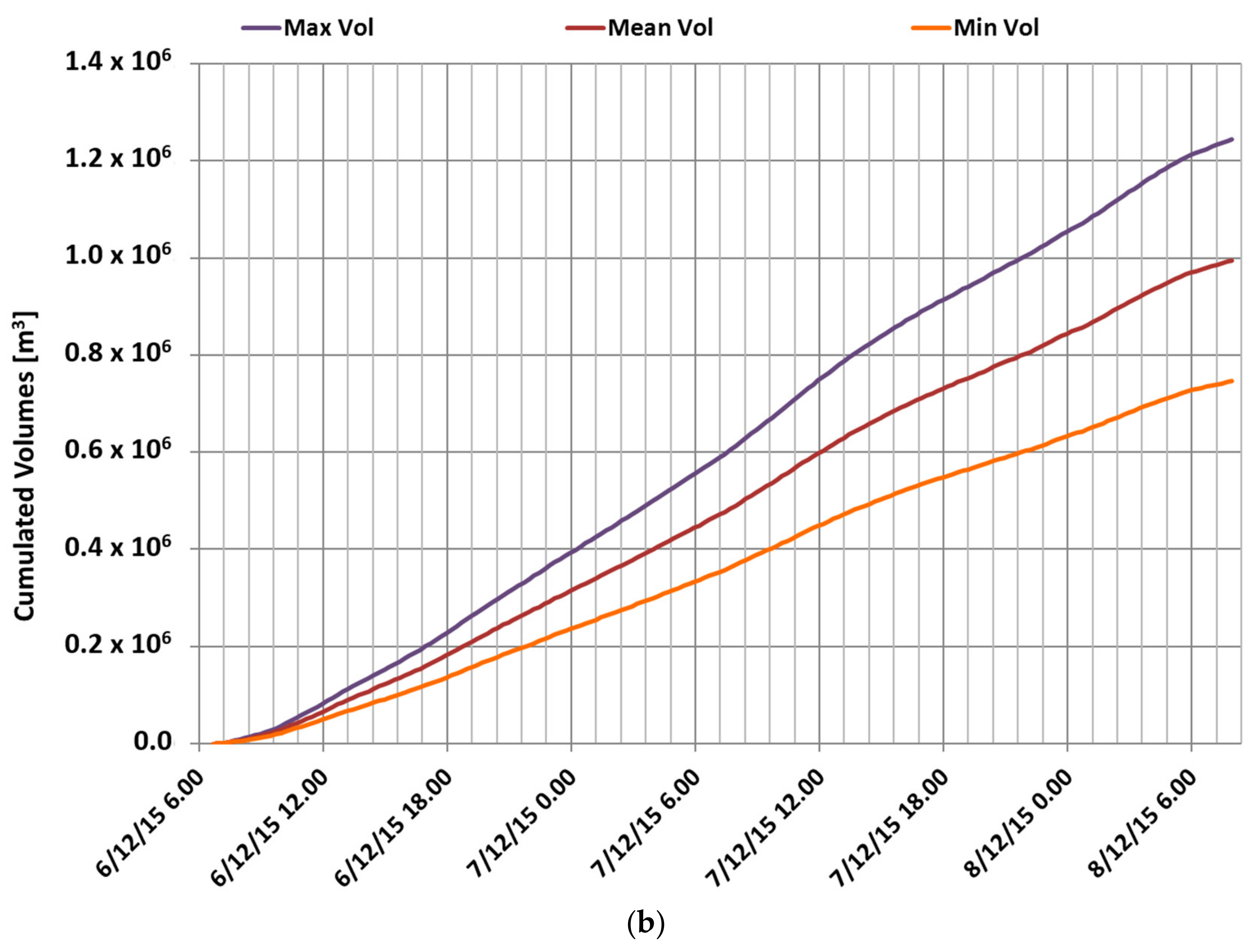
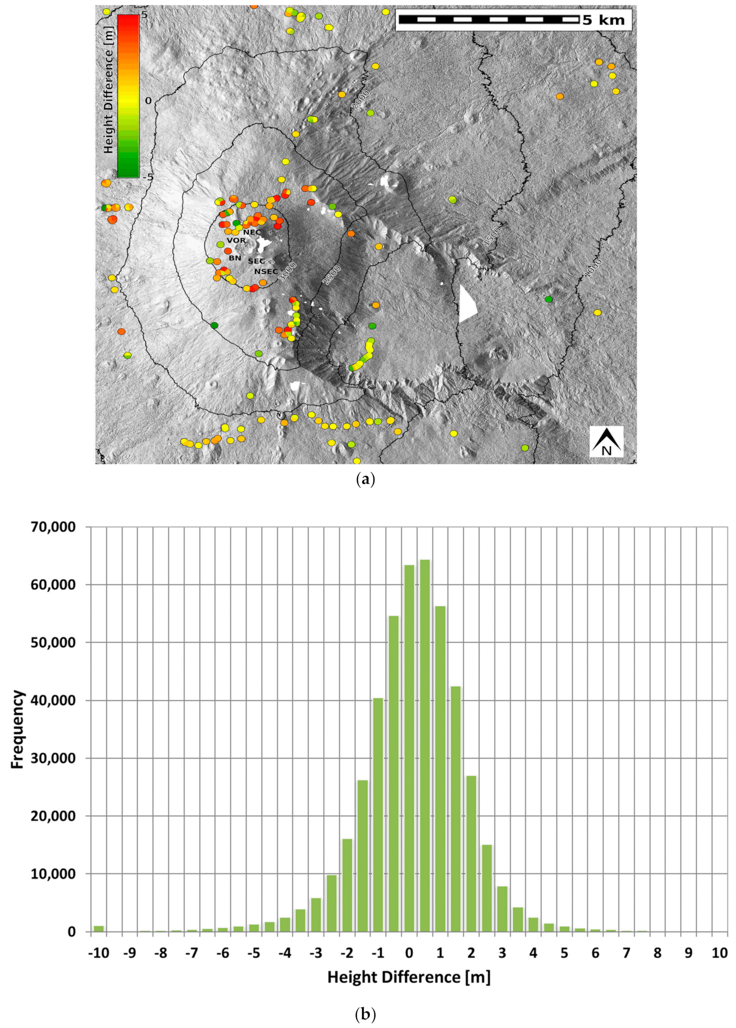
1. Summary
2. Data Description
3. Methods
Supplementary Materials
Author Contributions
Funding
Acknowledgments
Conflicts of Interest
References
- Ramsey, M.S.; Harris, A.J.L. Volcanology 2020: How will thermal remote sensing of volcanic surface activity evolve over the next decade? J. Volcanol. Geotherm. Res. 2012, 249, 217–233. [Google Scholar] [CrossRef]
- Harris, A.J.L.; Flynn, L.P.; Keszthelyi, L.; Mouginis-Mark, P.J.; Rowland, S.K.; Resing, J.A. Calculation of lava effusion rates from Landsat TM data. Bull. Volcanol. 1998, 60, 52–71. [Google Scholar] [CrossRef]
- Wright, R.; Blake, S.; Harris, A.; Rothery, D. A simple explanation for the space-based calculation of lava eruption rates. Earth Planet. Sci. Lett. 2001, 192, 223–233. [Google Scholar] [CrossRef]
- Ganci, G.; Cappello, A.; Bilotta, G.; Herault, A.; Zago, V.; Del Negro, C. Mapping Volcanic Deposits of the 2011–2015 Etna Eruptive Events Using Satellite Remote Sensing. Front. Earth Sci. 2018, 6, 83. [Google Scholar] [CrossRef]
- Bernard, M.; Decluseau, D.; Gabet, L.; Nonin, P. 3D capabilities of Pleiades satellite. Int. Arch. Photogramm. Remote Sens. Spat. Inf. Sci. 2012, 39, 553–557. [Google Scholar] [CrossRef]
- Bagnardi, M.; González, P.J.; Hooper, A. High-resolution digital elevation model from tri-stereo Pleiades-1 satellite imagery for lava flow volume estimates at Fogo Volcano. Geophys. Res. Lett. 2016, 43, 6267–6275. [Google Scholar] [CrossRef]
- Ganci, G.; Vicari, A.; Fortuna, L.; Del Negro, C. The HOTSAT volcano monitoring system based on a combined use of SEVIRI and MODIS multispectral data. Ann. Geophys. 2011, 54. [Google Scholar] [CrossRef]
- Ganci, G.; Bilotta, G.; Cappello, A.; Hérault, A.; Del Negro, C. HOTSAT: A multiplatform system for the satellite thermal monitoring of volcanic activity. Geol. Soc. Lond. Spec. Publ. 2016, 426, 207–221. [Google Scholar] [CrossRef]
- Wooster, M.J.; Zhukov, B.; Oertel, D. Fire radiative energy for quantitative study of biomass burning: Derivation from the BIRD experimental satellite and comparison to MODIS fire products. Remote Sens. Environ. 2003, 86, 83–107. [Google Scholar] [CrossRef]
- Rupnik, E.; Daakir, M.; Pierrot Deseilligny, M. MicMac—A free, open-source solution for photogrammetry. Open Geospat. Data, Softw. Stand. 2017, 14. [Google Scholar] [CrossRef]
- Ganci, G.; Cappello, A.; Bilotta, G.; Hérault, A.; Zago, V.; Del Negro, C. 3D Lava flow mapping at Etna volcano from Pléiades-derived DEM differences. PANGAEA 2019. [Google Scholar] [CrossRef]
- Nuth, C.; Kääb, A. Co-registration and bias corrections of satellite elevation data sets for quantifying glacier thickness change. Cryosphere 2011, 5, 271–290. [Google Scholar] [CrossRef]
- Del Negro, C.; Cappello, A.; Ganci, G. Quantifying Lava Flow Hazards in Response to Effusive Eruption. Bull. Geol. Soc. Am. 2016, 128, 1–13. [Google Scholar] [CrossRef]
- Ganci, G.; Cappello, A.; Zago, V.; Bilotta, G.; Hérault, A.; Del Negro, C. 3D Lava flow mapping of the 17–25 May 2016 Etna eruption using tri-stereo optical satellite data. Ann. Geophys. 2018, 61. [Google Scholar] [CrossRef]


| Deposit | Thickness [m] | Area [m2] | Volume [×106 m3] | |||
|---|---|---|---|---|---|---|
| Mean | Max | Min | Mean | Max | ||
| Cone | 4.81 | 20.39 | 79,024 | 0.23 | 0.38 | 0.53 |
| Flows | 5.40 | 20.09 | 435,276 | 1.50 | 2.35 | 3.20 |
| Total | 5.31 | 20.39 | 514,300 | 1.73 | 2.73 | 3.73 |
© 2019 by the authors. Licensee MDPI, Basel, Switzerland. This article is an open access article distributed under the terms and conditions of the Creative Commons Attribution (CC BY) license (http://creativecommons.org/licenses/by/4.0/).
Share and Cite
Ganci, G.; Cappello, A.; Bilotta, G.; Corradino, C.; Del Negro, C. Satellite-Based Reconstruction of the Volcanic Deposits during the December 2015 Etna Eruption. Data 2019, 4, 120. https://doi.org/10.3390/data4030120
Ganci G, Cappello A, Bilotta G, Corradino C, Del Negro C. Satellite-Based Reconstruction of the Volcanic Deposits during the December 2015 Etna Eruption. Data. 2019; 4(3):120. https://doi.org/10.3390/data4030120
Chicago/Turabian StyleGanci, Gaetana, Annalisa Cappello, Giuseppe Bilotta, Claudia Corradino, and Ciro Del Negro. 2019. "Satellite-Based Reconstruction of the Volcanic Deposits during the December 2015 Etna Eruption" Data 4, no. 3: 120. https://doi.org/10.3390/data4030120
APA StyleGanci, G., Cappello, A., Bilotta, G., Corradino, C., & Del Negro, C. (2019). Satellite-Based Reconstruction of the Volcanic Deposits during the December 2015 Etna Eruption. Data, 4(3), 120. https://doi.org/10.3390/data4030120