Evaluation of Photogrammetry and Inclusion of Control Points: Significance for Infrastructure Monitoring


Abstract
1. Introduction
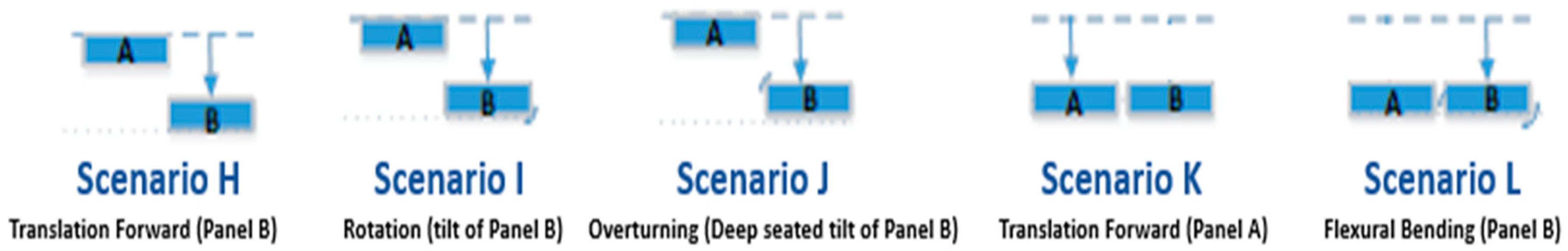
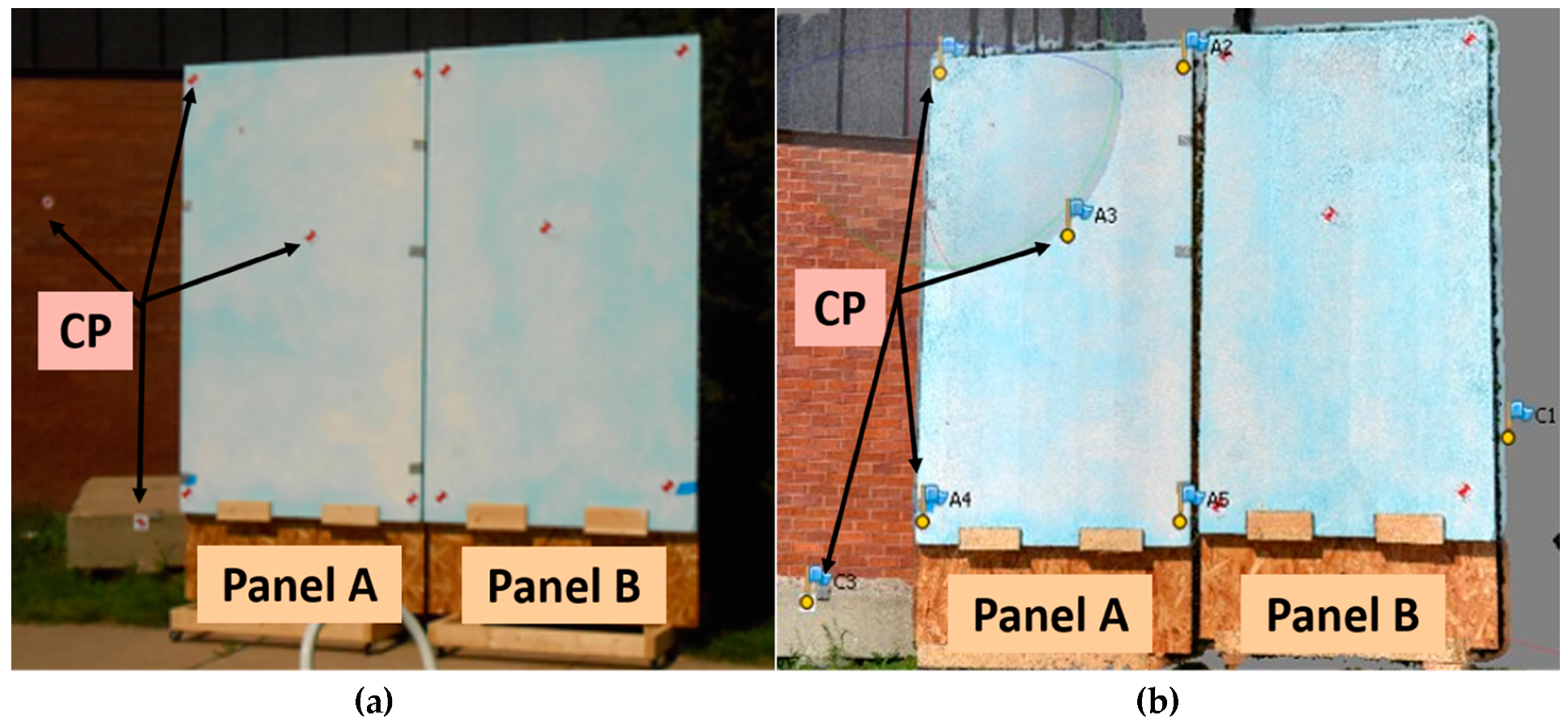
2. Methods and Experimental Data Setup
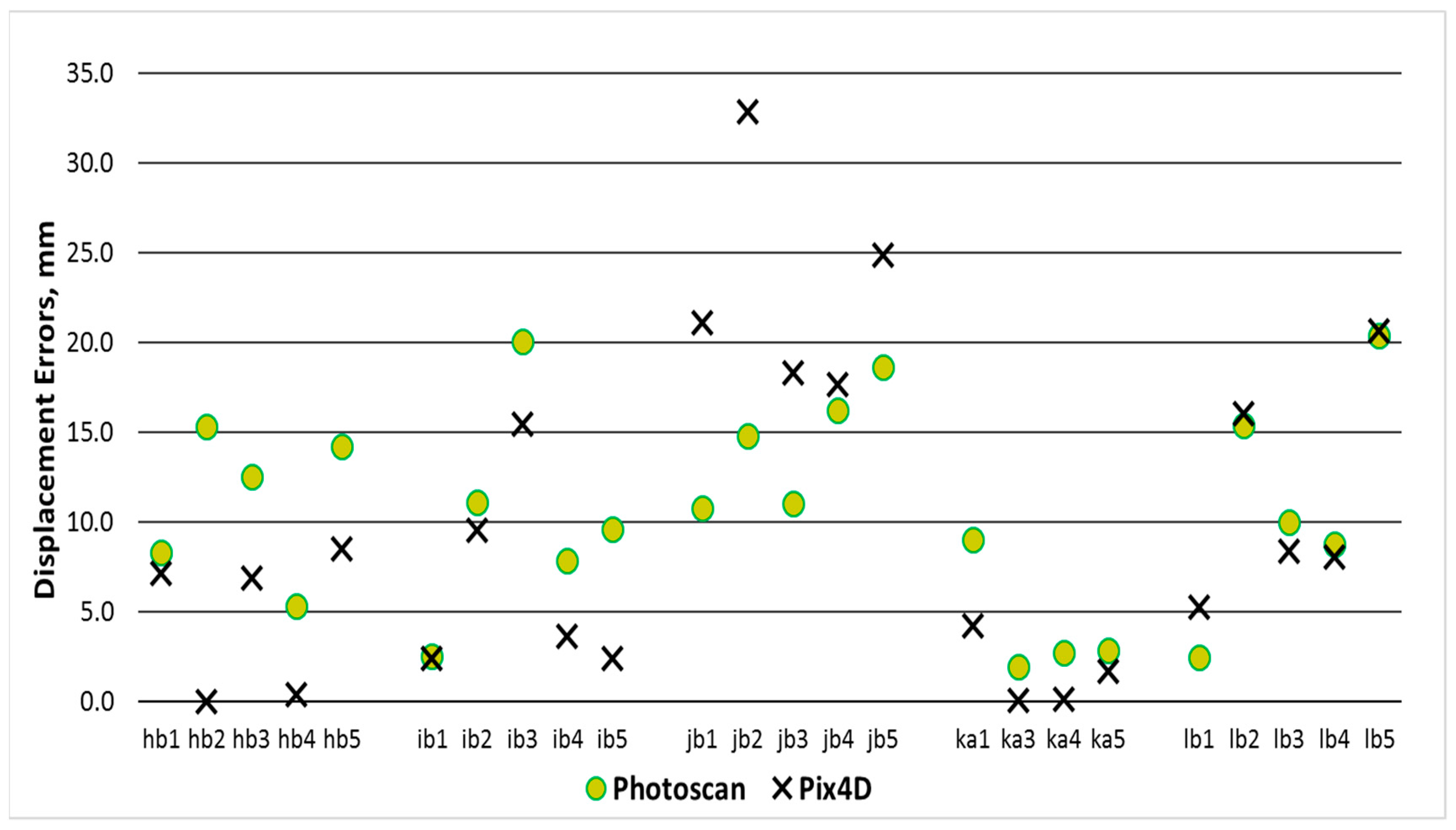
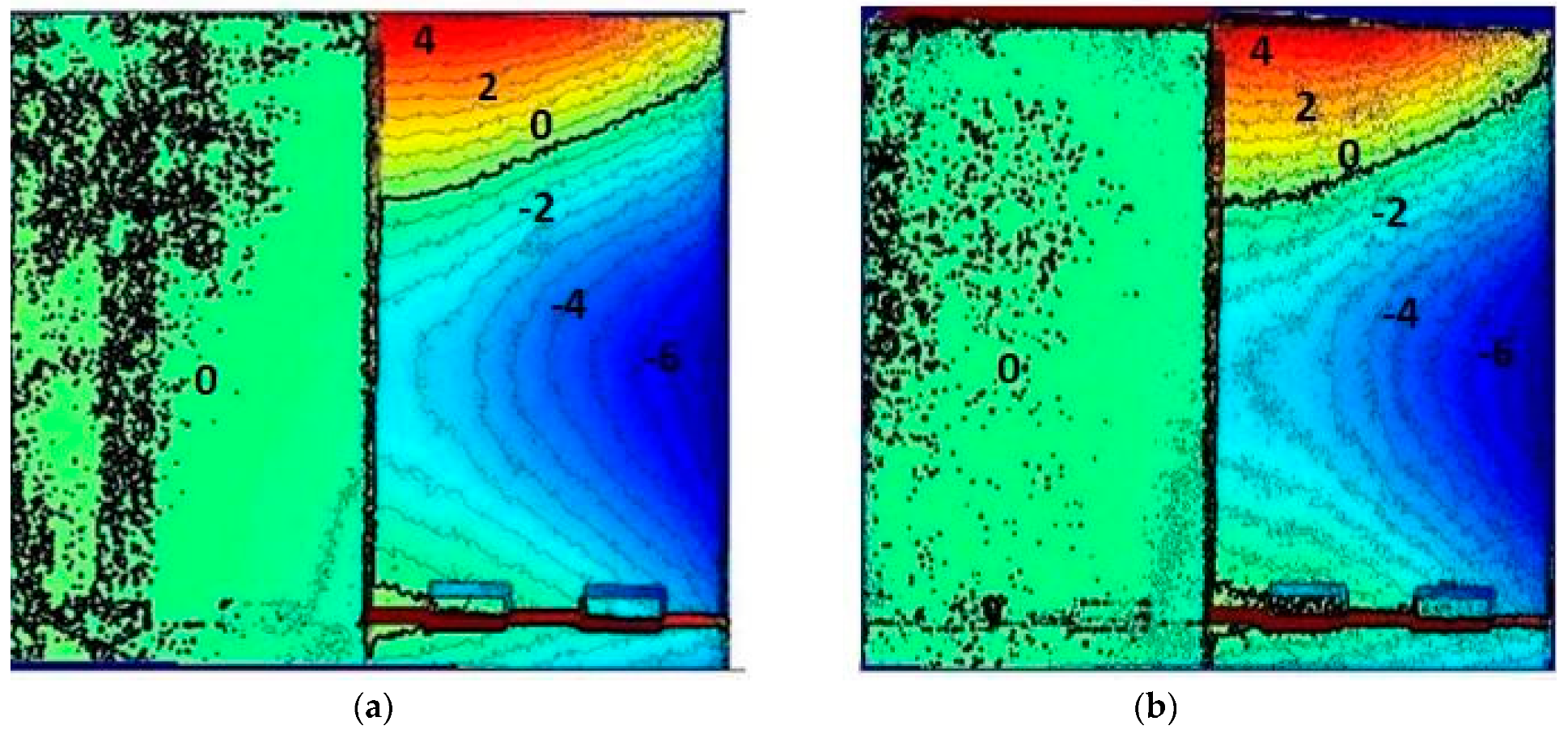
3. Results and Discussion
4. Conclusions
Author Contributions
Funding
Acknowledgments
Conflicts of Interest
Disclaimer
References
- Wolf, P.R.; Dewitt, B.A.; Wilkinson, B.E. Elements of Photogrammetry: With Applications in GIS; McGraw-Hill: New York, NY, USA, 2000. [Google Scholar]
- Khaloo, A.; Lattanzi, D. Hierarchical dense structure-from-motion reconstructions for infrastructure condition assessment. J. Comput. Civ. Eng. 2016, 31, 04016047. [Google Scholar] [CrossRef]
- Han, J.; Hong, K.; Kim, S. Application of a photogrammetric system for monitoring civil engineering structures. In Special Applications of Photogrammetry; InTech: London, UK, 2012. [Google Scholar]
- Dai, F.; Rashidi, A.; Brilakis, I.; Vela, P. Comparison of image-based and time-of-flight-based technologies for three-dimensional reconstruction of infrastructure. J. Constr. Eng. Manag. 2012, 139, 69–79. [Google Scholar] [CrossRef]
- Dai, F.; Lu, M.; Kamat, V.R. Analytical approach to augmenting site photos with 3D graphics of underground infrastructure in construction engineering applications. J. Comput. Civ. Eng. 2010, 25, 66–74. [Google Scholar] [CrossRef]
- Zhu, Z.; Brilakis, I. Comparison of optical sensor-based spatial data collection techniques for civil infrastructure modeling. J. Comput. Civ. Eng. 2009, 23, 170–177. [Google Scholar] [CrossRef]
- Kim, D.H.; Gratchev, I.; Balasubramaniam, A. A photogrammetric approach for stability analysis of weathered rock slopes. Geotech. Geol. Eng. 2015, 33, 443–454. [Google Scholar] [CrossRef]
- Ceylan, H.; Gopalakrishnan, K.; Kim, S.; Taylor, P.C.; Prokudin, M.; Buss, A.F. Highway infrastructure health monitoring using micro-electromechanical sensors and systems (MEMS). J. Civ. Eng. Manag. 2013, 19, S188–S201. [Google Scholar] [CrossRef]
- Oats, R.C.; Escobar-Wolf, R.; Oommen, T. A Novel Application of Photogrammetry for Retaining Wall Assessment. Infrastructures 2017, 2, 10. [Google Scholar] [CrossRef]
- Anderson, S.A.; Alzamora, D.; DeMarco, M.J. Asset Management Systems for Retaining Wall. In Proceedings of the Biennial Geotechnical Seminar Conference, Denver, CO, USA, 7 November 2008; pp. 162–177. [Google Scholar]
- Butler, C.J.; Gabr, M.A.; Rasdorf, W.; Findley, D.J.; Chang, J.C.; Hammit, B.E. Retaining wall field condition inspection, rating analysis, and condition assessment. J. Perform. Constr. Facil. 2015, 30, 04015039. [Google Scholar] [CrossRef]
- AASHTO. Transportation Asset Management Guide: A Focus on Implementation; American Association of State Highway and Transportation Officials (AASHTO): Washington, DC, USA, 2013. [Google Scholar]
- Almeida, N.M.; Sousa, V.; Dias, L.A.; Branco, F. Engineering risk management in performance-based building environments. J. Civ. Eng. Manag. 2015, 21, 218–230. [Google Scholar] [CrossRef]
- Bhatla, A.; Choe, S.Y.; Fierro, O.; Leite, F. Evaluation of accuracy of as-built 3D modeling from photos taken by handheld digital cameras. Autom. Constr. 2012, 28, 116–127. [Google Scholar] [CrossRef]
- Riveiro, B.; Jauregui, D.V.; Arias, P.; Armesto, J.; Jiang, R. An innovative method for remote measurement of minimum vertical underclearance in routine bridge inspection. Autom. Constr. 2012, 25, 34–40. [Google Scholar] [CrossRef]
- Golparvar-Fard, M.; Bohn, J.; Teizer, J.; Savarese, S.; Peña-Mora, F. Evaluation of image-based modeling and laser scanning accuracy for emerging automated performance monitoring techniques. Autom. Constr. 2011, 20, 1143–1155. [Google Scholar] [CrossRef]
- Zhou, Z.; Gong, J.; Guo, M. Image-based 3D reconstruction for post-hurricane residential building damage assessment. J. Comput. Civ. Eng. 2015, 30, 04015015. [Google Scholar] [CrossRef]
- Clayton, C.R.; Woods, R.I.; Bond, A.J.; Milititsky, J. Earth Pressure and Earth-Retaining Structures; CRC Press: Boca Raton, FL, USA, 2014. [Google Scholar]
- DeMarco, M.J.; Anderson, S.A.; Armstrong, A. Retaining Walls Are Assets Too! Public Roads 2009, 73, 30–37. [Google Scholar]
- Gul, M.; Catbas, F.N.; Hattori, H. Image-based monitoring of open gears of movable bridges for condition assessment and maintenance decision making. J. Comput. Civ. Eng. 2013, 29, 04014034. [Google Scholar] [CrossRef]
- Slaker, B.A. Monitoring Underground Mine Displacement Using Photogrammetry and Laser Scanning. Ph.D. Thesis, Virginia Polytechnic Institute and State University, Blacksburg, VA, USA, 2015. [Google Scholar]
- Escobar-Wolf, R.; Oommen, T.; Brooks, C.N.; Dobson, R.J.; Ahlborn, T.M. Unmanned aerial vehicle (UAV)-based assessment of concrete bridge deck delamination using thermal and visible camera sensors: A preliminary analysis. Res. Nondestruct. Eval. 2018, 29, 183–198. [Google Scholar] [CrossRef]
- Kalacska, M.; Lucanus, O.; Sousa, L.; Vieira, T.; Arroyo-Mora, J.P. UAV-Based 3D Point Clouds of Freshwater Fish Habitats, Xingu River Basin, Brazil. Data 2019, 4, 9. [Google Scholar] [CrossRef]
- Scotland, I.; Dixon, N.; Frost, M.W.; Wackrow, R.; Fowmes, G.J.; Horgan, G. Measuring Deformation Performance of Geogrid Reinforced Structures Using a Terrestrial Laser Scanner; Loughborough University Institutional Repository: Leicestershire, UK, 2014. [Google Scholar]
- Mill, T.; Alt, A.; Liias, R. Combined 3D building surveying techniques–terrestrial laser scanning (TLS) and total station surveying for BIM data management purposes. J. Civ. Eng. Manag. 2013, 19, S23–S32. [Google Scholar] [CrossRef]
- Henke, K.; Pawlowski, R.; Schregle, P.; Winter, S. Use of digital image processing in the monitoring of deformations in building structures. J. Civ. Struct. Health Monit. 2015, 5, 141–152. [Google Scholar] [CrossRef]
- Jiang, R.; Jáuregui, D.V.; White, K.R. Close-range photogrammetry applications in bridge measurement: Literature review. Measurement 2008, 41, 823–834. [Google Scholar] [CrossRef]
- Calì, M.; Ambu, R. Advanced 3D Photogrammetric Surface Reconstruction of Extensive Objects by UAV Camera Image Acquisition. Sensors 2018, 18, 2815. [Google Scholar] [CrossRef]
- Gindraux, S.; Boesch, R.; Farinotti, D. Accuracy assessment of digital surface models from unmanned aerial vehicles’ imagery on glaciers. Remote Sens. 2017, 9, 186. [Google Scholar] [CrossRef]
- Westoby, M.J.; Brasington, J.; Glasser, N.F.; Hambrey, M.J.; Reynolds, J.M. Structure-from-Motion’ photogrammetry: A low-cost, effective tool for geoscience applications. Geomorphology 2012, 179, 300–314. [Google Scholar] [CrossRef]
- Forlani, G.; Pinto, L.; Roncella, R.; Pagliari, D. Terrestrial photogrammetry without ground control points. Earth Sci. Inform. 2014, 7, 71–81. [Google Scholar] [CrossRef]
- Dai, F.; Feng, Y.; Hough, R. Photogrammetric error sources and impacts on modeling and surveying in construction engineering applications. Visual. Eng. 2014, 2, 2. [Google Scholar] [CrossRef]
- Tahar, K.N. An evaluation on different number of ground control points in unmanned aerial vehicle photogrammetric block. Int. Arch. Photogramm. Remote Sens. Spat. Inf. Sci. 2013, 40, 93–98. [Google Scholar] [CrossRef]
- Benassi, F.; Dall’Asta, E.; Diotri, F.; Forlani, G.; Morra di Cella, U.; Roncella, R.; Santise, M. Testing accuracy and repeatability of UAV blocks oriented with GNSS-supported aerial triangulation. Remote Sens. 2017, 9, 172. [Google Scholar] [CrossRef]
- Liew, L.H.; Wang, Y.C.; Cheah, W.S. Evaluation of control points’ distribution on distortions and geometric transformations for aerial images rectification. Procedia Eng. 2012, 41, 1002–1008. [Google Scholar] [CrossRef]
- Udin, W.S.; Ahmad, A. Assessment of photogrammetric mapping accuracy based on variation flying altitude using unmanned aerial vehicle. In IOP Conference Series: Earth and Environmental Science; IOP Publishing: Bristol, UK, 2014; Volume 18, p. 012027. [Google Scholar]
- Chen, Y.C.; Tseng, Y.H. Advancement of Close Range Photogrammetry with a Portable Panoramic Image Mapping System (Ppims); The Photogrammetric Record: Hoboken, NJ, USA, 2018. [Google Scholar]
- Fraser, C. Advances in Close Range Photogrammetry. Available online: www.ifp.uni-stuttgart.de/publications/phowo15/260Fraser.pdf (accessed on 25 September 2018).
- Federal Highway Administration United States Department of Transportation. Mechanically Stabilized Earth Walls and Reinforced Soil Slopes Design & Construction Guidelines; Publication No. FHWA-NHI-00-043; National Highway Institute (NHI) Office of Bridge Technology: Washington, DC, USA, 2001.
- Power, M.; Fishman, K.L.; Makdisi, F.; Musser, S.; Richards, R., Jr.; Youd, T.L. Seismic Retrofitting Manual for Highway Structures: Part 2-Retaining Structures, Slopes, Tunnels, Culverts and Roadways; Federal Highway Administration: Washington, DC, USA, 2006.
- Muni, B. Soil Mechanics & Foundations; John Wiley & Sons, Inc.: Hoboken, NJ, USA, 2010. [Google Scholar]
- Su, Y.Y.; Hashash, Y.M.A.; Liu, L.Y. Integration of construction as-built data via laser scanning with geotechnical monitoring of urban excavation. J. Constr. Eng. Manag. 2006, 132, 1234–1241. [Google Scholar] [CrossRef]
- Gong, J.; Zhou, H.; Gordon, C.; Jalayer, M. Mobile terrestrial laser scanning for highway inventory data collection. Comput. Civ. Eng. 2012, 545–552. [Google Scholar] [CrossRef]
- Tung, S.H.; Weng, M.C.; Shih, M.H. Measuring the in situ deformation of retaining walls by the digital image correlation method. Eng. Geol. 2013, 166, 116–126. [Google Scholar] [CrossRef]
- Maltezos, E.; Skitsas, M.; Charalambous, E.; Koutras, N.; Bliziotis, D.; Themistocleous, K. Critical infrastructure monitoring using UAV imagery. In Fourth International Conference on Remote Sensing and Geoinformation of the Environment (RSCy2016); International Society for Optics and Photonics: Bellingham, WA, USA, 2016; Volume 9688, p. 96880P. [Google Scholar]
- Bakula, K.; Ostrowski, W.; Szender, M.; Plutecki, W.; Salach, A.; Górski, K. Possibilities for Using LIDAR and Photogrammetric Data Obtained with AN Unmanned Aerial Vehicle for Levee Monitoring. Int. Arch. Photogramm. Remote Sens. Spat. Inf. Sci. 2016, 41, 773–780. [Google Scholar] [CrossRef]
- Shahbazi, M.; Sohn, G.; Théau, J.; Menard, P. Development and evaluation of a UAV-photogrammetry system for precise 3D environmental modeling. Sensors 2015, 15, 27493–27524. [Google Scholar] [CrossRef]
- Rosnell, T.; Honkavaara, E. Point cloud generation from aerial image data acquired by a quadrocopter type micro unmanned aerial vehicle and a digital still camera. Sensors 2012, 12, 453–480. [Google Scholar] [CrossRef]
- Rock, G.; Ries, J.B.; Udelhoven, T. Sensitivity analysis of UAV-photogrammetry for creating digital elevation models (DEM). Int. Arch. Photogramm. Remote Sens. Spat. Inf. Sci. 2011, XXXVIII-1/C22, 69–73. [Google Scholar] [CrossRef]
- Tonkin, T.N.; Midgley, N.G. Ground-control networks for image based surface reconstruction: An investigation of optimum survey designs using UAV derived imagery and structure-from-motion photogrammetry. Remote Sens. 2016, 8, 786. [Google Scholar] [CrossRef]
- Sisiopiku, V.P.; Rostami-Hosuri, S. Congestion Quantification Using the National Performance Management Research Data Set. Data 2017, 2, 39. [Google Scholar] [CrossRef]


© 2019 by the authors. Licensee MDPI, Basel, Switzerland. This article is an open access article distributed under the terms and conditions of the Creative Commons Attribution (CC BY) license (http://creativecommons.org/licenses/by/4.0/).
Share and Cite
Oats, R.C.; Escobar-Wolf, R.; Oommen, T. Evaluation of Photogrammetry and Inclusion of Control Points: Significance for Infrastructure Monitoring. Data 2019, 4, 42. https://doi.org/10.3390/data4010042
Oats RC, Escobar-Wolf R, Oommen T. Evaluation of Photogrammetry and Inclusion of Control Points: Significance for Infrastructure Monitoring. Data. 2019; 4(1):42. https://doi.org/10.3390/data4010042
Chicago/Turabian StyleOats, Renee C., Rudiger Escobar-Wolf, and Thomas Oommen. 2019. "Evaluation of Photogrammetry and Inclusion of Control Points: Significance for Infrastructure Monitoring" Data 4, no. 1: 42. https://doi.org/10.3390/data4010042
APA StyleOats, R. C., Escobar-Wolf, R., & Oommen, T. (2019). Evaluation of Photogrammetry and Inclusion of Control Points: Significance for Infrastructure Monitoring. Data, 4(1), 42. https://doi.org/10.3390/data4010042