
Karst Brackish Springs of Albania


Abstract
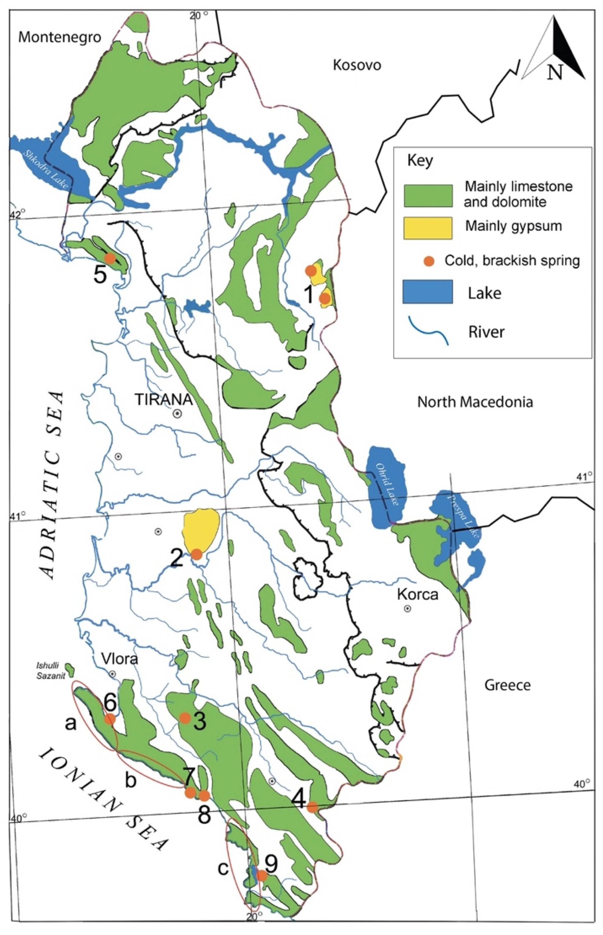
:1. Introduction
2. Springs in Evaporitic Deposits
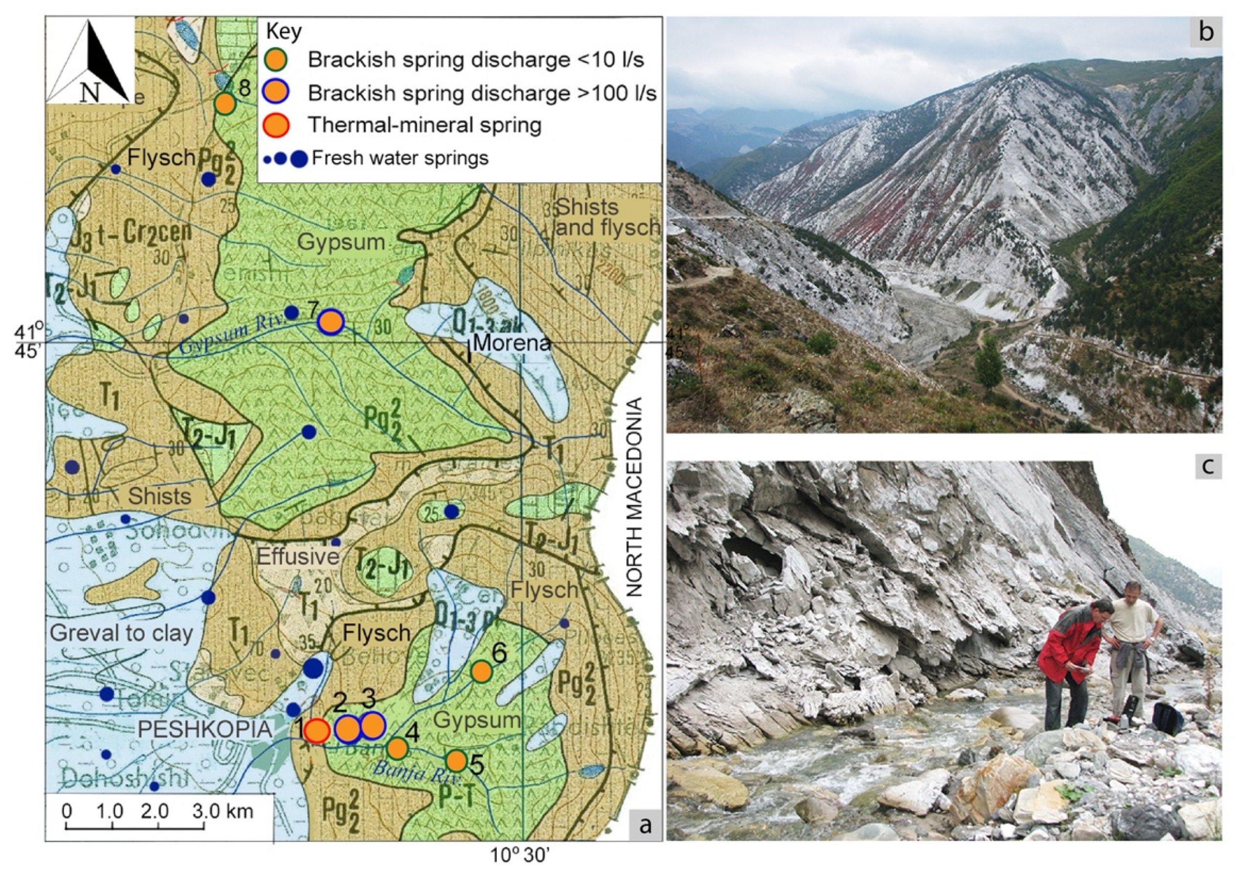
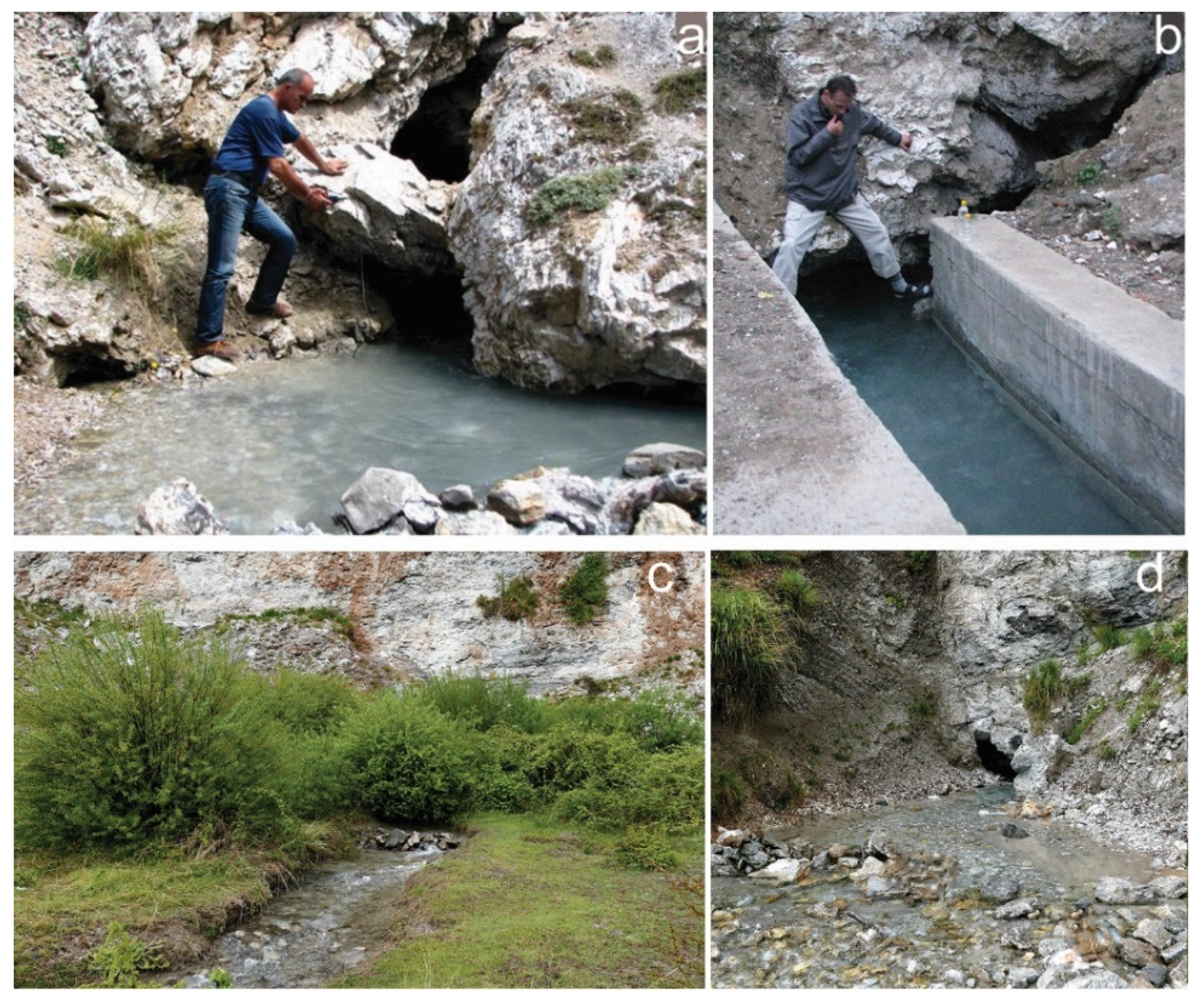
2.1. Springs in Korab Area

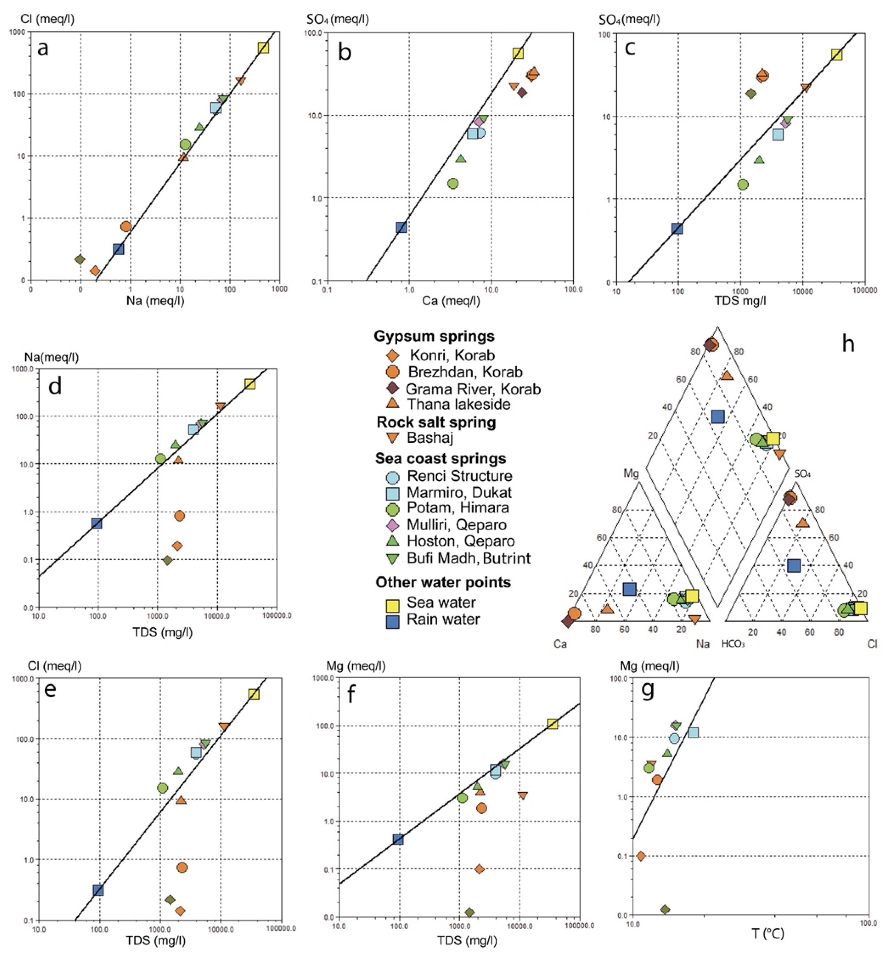
| Location | Spring Name | Rock Type | Q l/s | T °C | pH - | EC µS/cm | TDS mg/L | Ca mg/L | Mg mg/L | Na+K mg/L | Cl mg/L | SO4 mg/L | HCO3 mg/L | Hydrochem. Facies | Mg/Ca - | Na/Cl - | |
|---|---|---|---|---|---|---|---|---|---|---|---|---|---|---|---|---|---|
| Springs in evaporitic rocks | |||||||||||||||||
| Korab | Brezhdan | G | 100 | 12.7 | 6.12 | 2480 | 2309 | 636 | 22.8 | 18.8 | 3.48 | 26.0 | 1491 | 180.0 | SO4-Ca | 0.36 | 1.11 |
| Konri | G | 70 | 10.8 | 7.11 | 2350 | 2127 | 614.0 | 1.2 | 4.45 | 1.13 | 5.0 | 1404 | 207.0 | SO4-Ca | 0.03 | 1.36 | |
| Gypsum River | G | 250 | 13.7 | 8.10 | 1852 | 1470 | 474.0 | 0.0 | 2.2 | 0.71 | 7.6 | 902.0 | 153.0 | SO4-Ca | - | 0.45 | |
| Vlesha | G | 9.0 | 13.2 | 7.52 | 2110 | 2376 | 704.2 | 6.44 | 1.13 | 0.10 | 0.16 | 1589.0 | 190.2 | SO4-Ca | - | - | |
| Dumre | Thana lake | G | 10.0 | - | 7.0 | - | 3286 | 663.3 | 48.0 | 268.6 | 329.8 | 592.1 | 308.6 | SO4−Cl-Ca-Na | 0.12 | 1.25 | |
| Thana Leke | G | 7.0 | 15.7 | 6.8 | 3410 | 2636 | 612.9 | 70.4 | 148.9 | 3.15 | 247.3 | 1313 | 377.2 | SO4-(Cl)-Ca-(Na) | 0.19 | 0.94 | |
| Bashaj | Bashaj, Smokthinë | GH | 20.0 | 12.0 | 7.4 | - | 11284 | 376.8 | 43.7 | 3812.5 | 37.9 | 5813.8 | 1083.2 | 158.6 | Cl-Na | 0.19 | 1.01 |
| Springs in carbonate rocks | |||||||||||||||||
| Renci structure | Nr 2, Shengjin | L | - | 18.0 | 7.7 | - | 7058.8 | 317.4 | 275.3 | 1915.9 | 66.8 | 3867.8 | 557.2 | 154.9 | Cl-Na | 1.43 | 076 |
| Renci Structure | L | 4.0 | 15.5 | - | - | 2650 | 123.5 | 91.6 | 741.0 | 1263.8 | 269.1 | 283.6 | Cl-Na | 1.2 | 0.9 | ||
| Kakariq | L | 7.0 | 15.5 | - | - | 2740 | 105.8 | 86.0 | 760.5 | 1249.6 | 263.4 | 286.7 | Cl-Na | 1.34 | 0.94 | ||
| Gjok Gjini, Kakariq | L | 1.0 | 15.5 | - | - | 4840 | 156.8 | 169.0 | 1429.0 | 2485.0 | 439.5 | 253.1 | Cl-Na | 1.7 | 0.89 | ||
| Renc | L | 8.0 | 15.0 | - | - | 3955 | 144.3 | 115.8 | 1193.9 | 1988.0 | 293.4 | 393.5 | Cl-Na | 1.3 | 0.93 | ||
| Renci | L | 7.0 | 17.2 | - | - | 1136 | 39.8 | 38.5 | 333.8 | 562.2 | 58.4 | 155.5 | Cl-Na | 1.6 | 0.91 | ||
| 1.2 km N to Lezha | L | 20.0 | - | - | - | 1954 | 35.8 | 127.0 | 519.1 | 1002.9 | 138.3 | 222.6 | Cl-Na | 5.8 | 0.8 | ||
| 3 km W to Lezha | L | 10.0 | 17.4 | - | - | 1830 | 71.6 | 60.6 | 534.7 | 891.0 | 144.8 | 225.7 | Cl-Na | 1.4 | 0.93 | ||
| Orikum | Marmiro | L | 80 | 18.0 | 7.6 | 2270 | 3940 | 118.5 | 143.3 | 1196.0 | 2094.5 | 288.7 | 283.0 | Cl-Na | 2.00 | 0.88 | |
| Himare | Potami | L | 200.0 | 11.7 | 7.7 | 2170 | 1100 | 67.5 | 36.8 | 295.6 | 541.3 | 72.0 | 152.5 | Cl-Na | 0.9 | 0.84 | |
| 50.0 | 12.0 | 7.8 | 1725 | 974 | 67.8 | 41.1 | 232.7 | 457.4 | 65.4 | 159.8 | Cl-Na | 1.0 | 0.78 | ||||
| 0–350 | 12.0 | 7.8 | 2420 | 1530 | 73.7 | 42.3 | 434.0 | 660.3 | 225.5 | 167.1 | Cl-Na | 0.95 | 1.01 | ||||
| Filikur | L | 7.0 | 13.0 | - | - | 1720.0 | 49.4 | 59.9 | 535.0 | 891.0 | 131.3 | 172.0 | Cl-Na | 2.0 | 0.93 | ||
| Qeparoi | Mulliri | L | 350.0 | 15.1 | 7.55 | 8410 | 5276 | 140.5 | 191.3 | 1604.5 | 2840.0 | 395.0 | 262.3 | Cl-Na | 2.24 | 0.87 | |
| Hoston 1 | L | 6.0 | 14.0 | 7.8 | 3320 | 1990 | 84.50 | 63.18 | 571.10 | 994.0 | 139.91 | 203.74 | Cl-Na | 1.23 | 0.89 | ||
| Hoston 2 | L | 4.0 | 14.2 | 7.85 | 3540 | 2055 | 95.50 | 53.64 | 581.2 | 994.0 | 146.08 | 207.4 | Cl-Na | 0.93 | 0.9 | ||
| Hoston 3 | L | 0.7 | 16.7 | 7.4 | 2070 | 1324 | 88.42 | 36.36 | 363.40 | 560.90 | 112.75 | 306.22 | Cl-Na | 0.67 | 1.0 | ||
| Butrint | Bufi 1 | L | 15.0 | 15.6 | 7.5 | 11,120 | 7240 | 176.8 | 237.8 | 2231.7 | 3905.0 | 562.5 | 225.7 | Cl-Na | 2.21 | 0.88 | |
| Bufi 2 | L | 17.0 | 15.6 | 7.6 | 13,530 | 8386 | 212.2 | 293.8 | 2584.3 | 4881.2 | 287.2 | 215.9 | Cl-Na | 2.27 | 0.81 | ||
| Bufi | L | 600.0 | 15.3 | 7.6 | 9300 | 5658 | 161.13 | 190.12 | 1701.0 | 3014.1 | 444.83 | 208.62 | Cl-Na | 1.94 | 0.87 | ||
| KML threshold value | 1500 | 100 | 50 | Na: 175 | 25 | 250 | |||||||||||
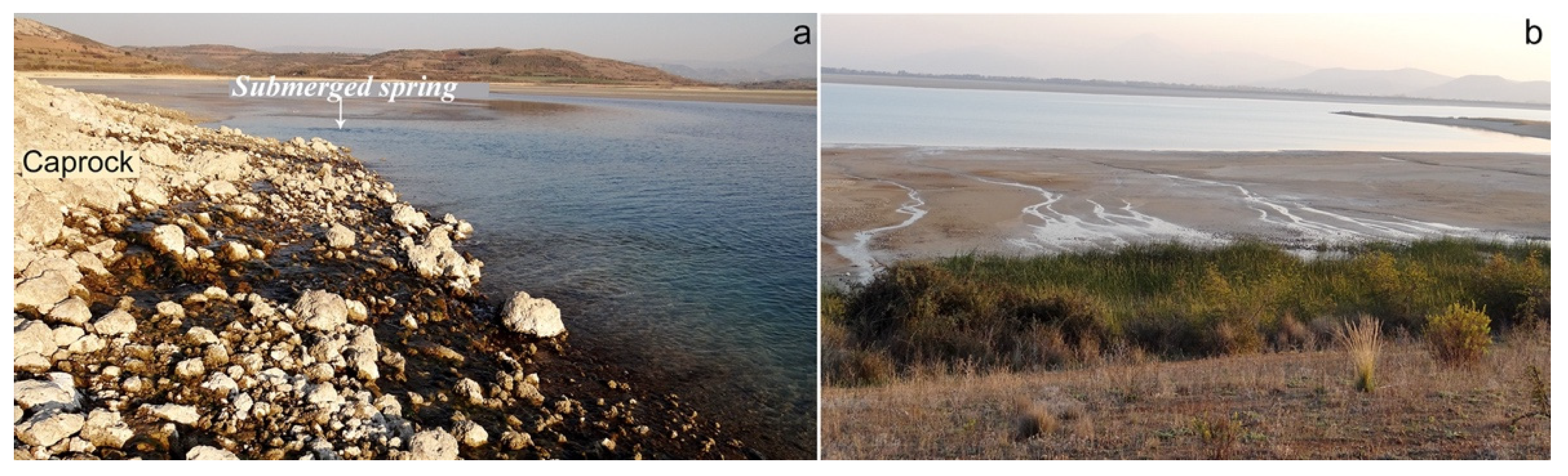
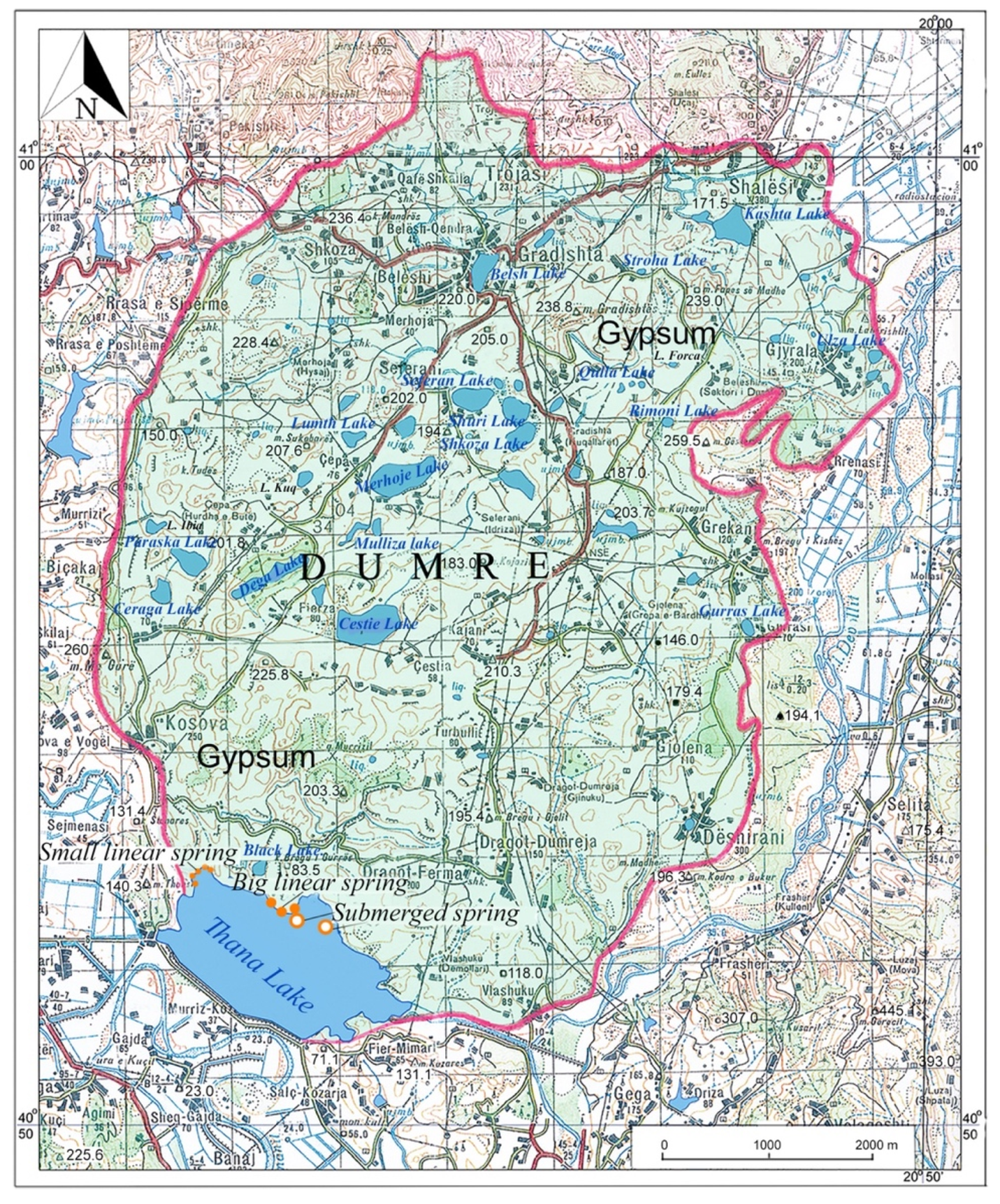
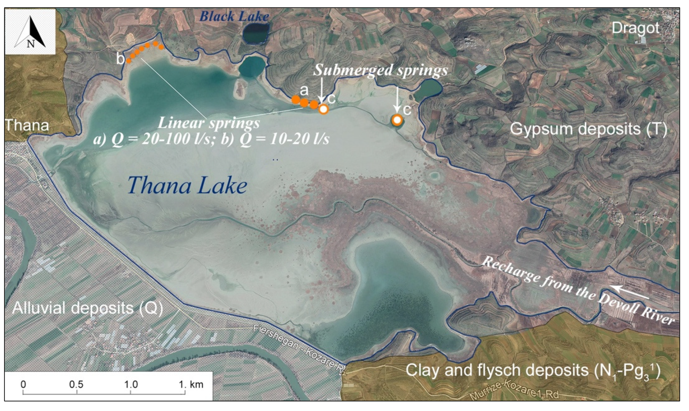
2.2. Springs of Dumre Plateau
- (a)
- The big linear springs, with the most important discharges, are located at the northernmost tip of Lake Thana (Figure 4 and Figure 5), and emerge from fine-granular deposits. The flowing front of the springs is up to several hundred meters in length, with the total flow (Figure 6b) estimated to fluctuate from 10 to 20 L/s;
- (b)
- (c)
2.3. Bashaj Spring
3. Coastal Springs
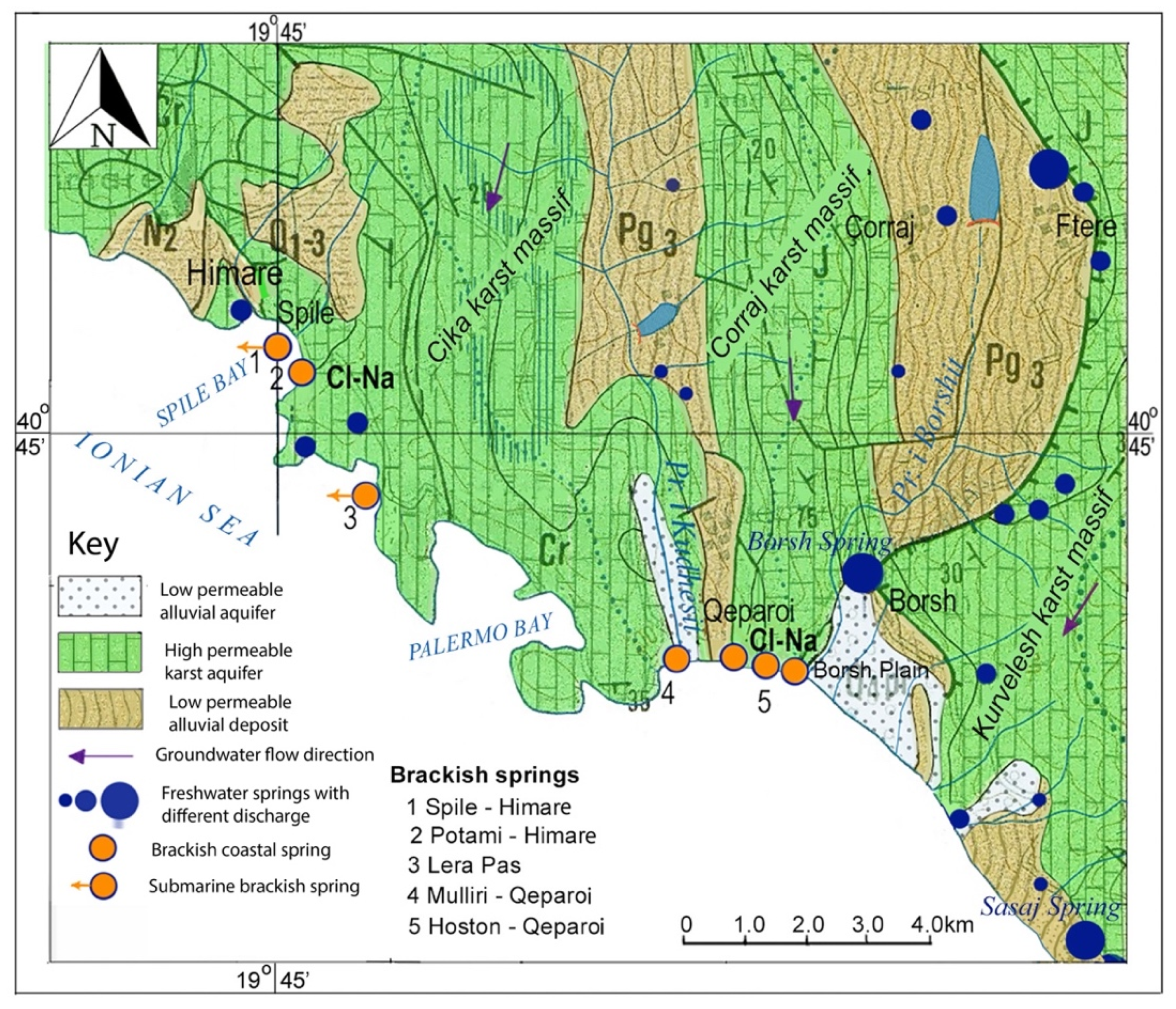
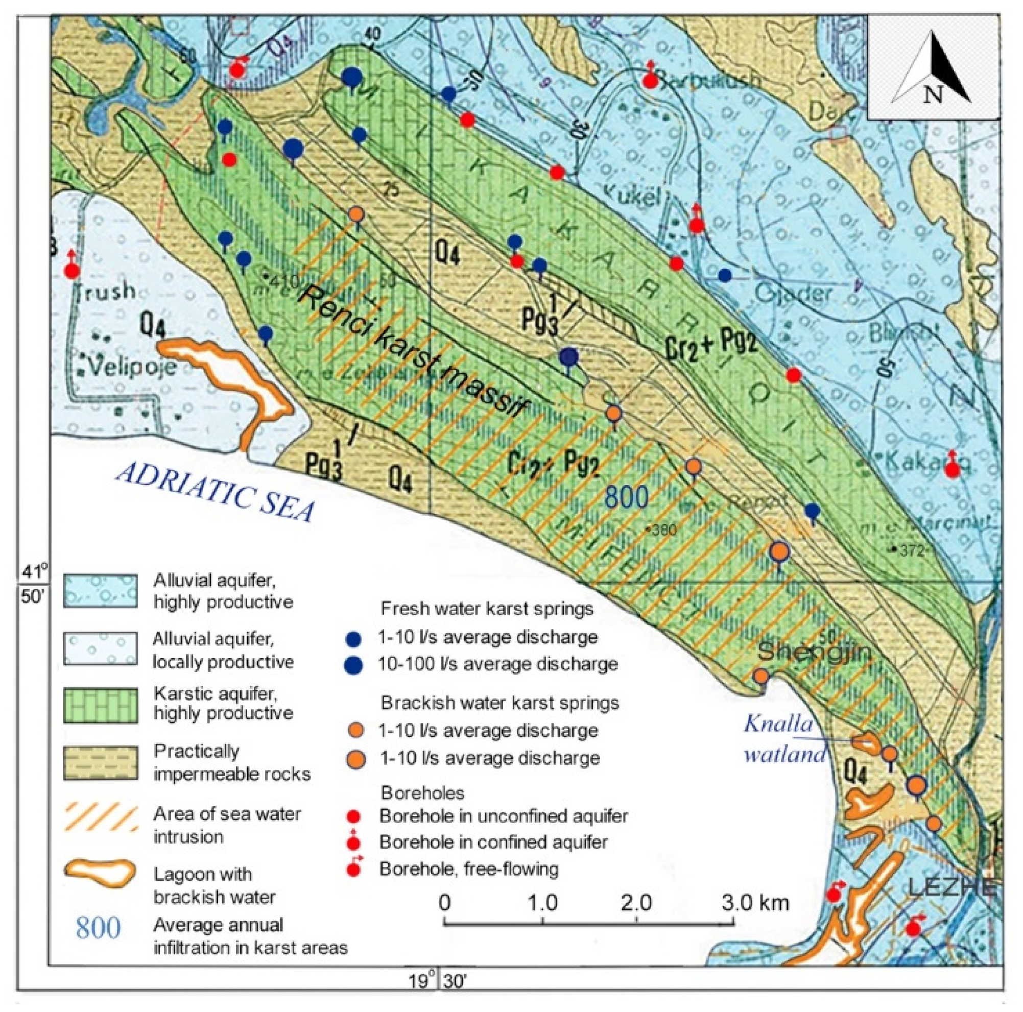
3.1. Springs of the Renci Structure
3.2. Springs of the Ionian Sea Rock Coast
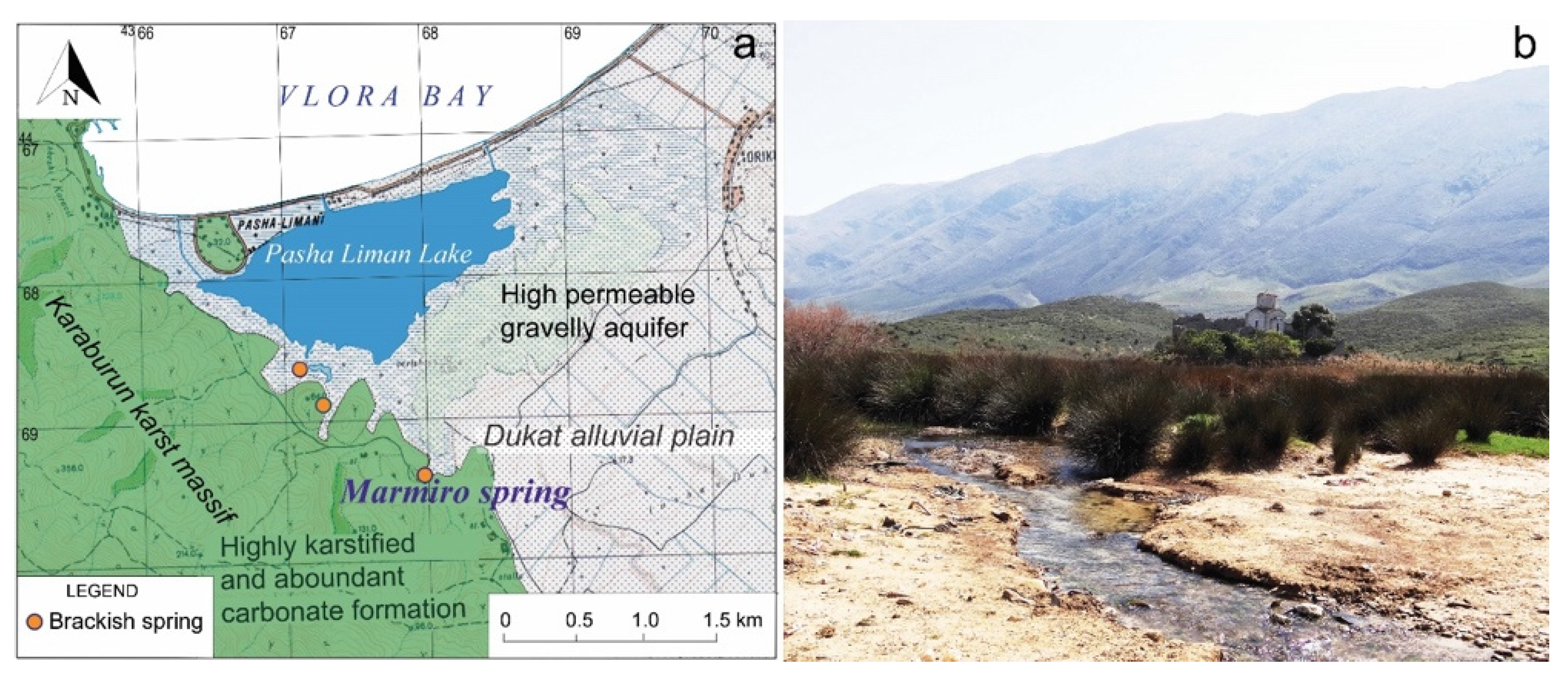
3.3. Marmiro Spring
3.4. Himare Springs
3.5. Qeparoi Springs
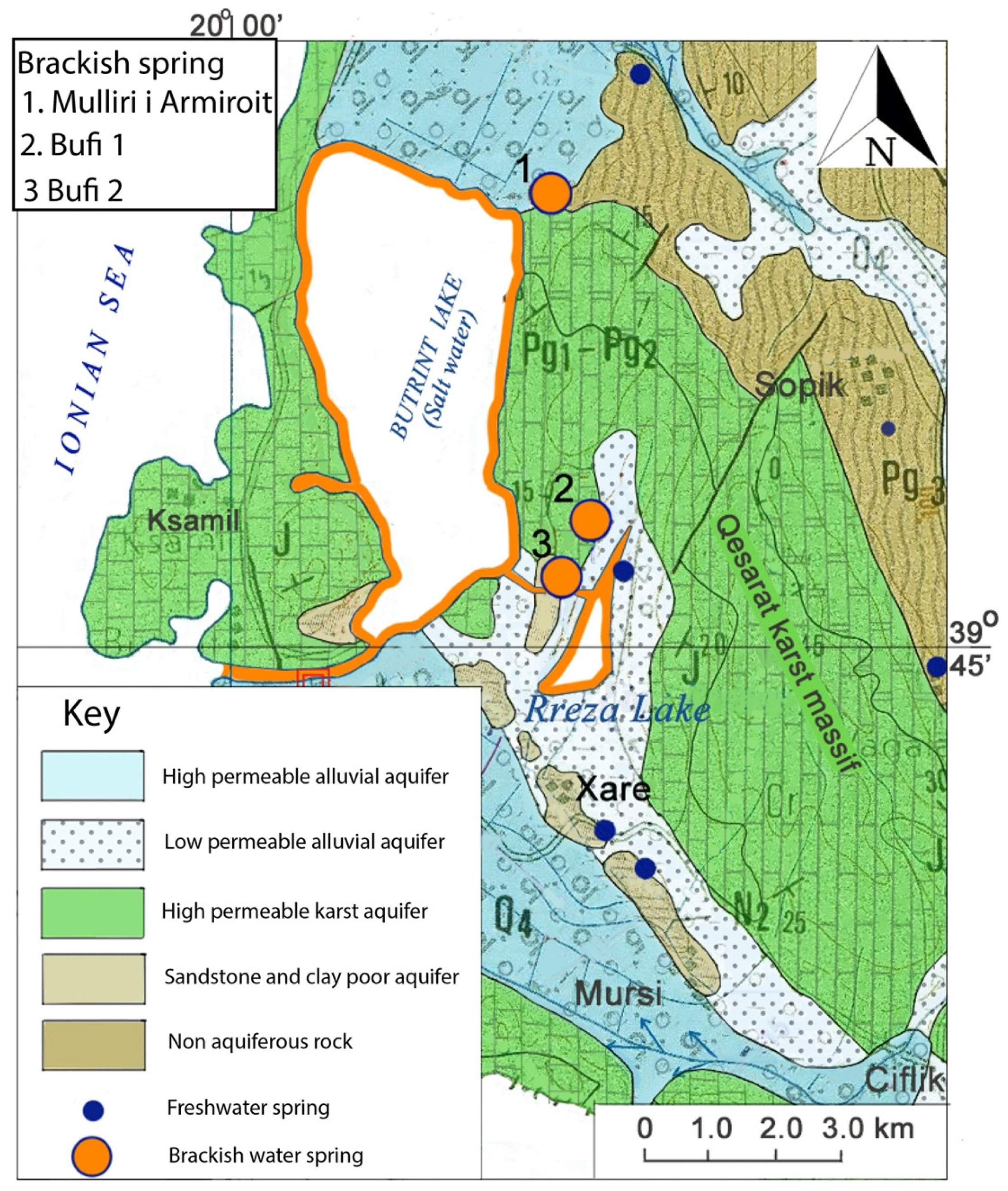
3.6. Butrint Springs
4. Hydrochemistry of Brackish Springs
5. Conclusions
Author Contributions
Funding
Institutional Review Board Statement
Informed Consent Statement
Data Availability Statement
Conflicts of Interest
References
- Bakalowicz, M. Karst groundwater: A challenge for new resources. Hydrogeol. J. 2005, 13, 148–160. [Google Scholar] [CrossRef]
- Parise, M.; Gabrovsek, F.; Kaufmann, G.; Ravbar, N. Recent advances in karst research: From theory to fieldwork and applications. In Advances in Karst Research: Theory, Fieldwork and Applications; Parise, M., Gabrovsek, F., Kaufmann, G., Ravbar, N., Eds.; Geological Society: London, UK, 2018; Volume 466, pp. 1–24. [Google Scholar] [CrossRef]
- Stevanović, Z. Kast water in potable water supply: A global scale overview. Environ. Earth Sci. 2019, 78, 662. [Google Scholar] [CrossRef]
- Goldscheider, N.; Chen, Z.; Auler, A.S.; Bakalowicz, M.; Broda, S.; Drew, D.; Hartmann, J.; Jiang, G.; Moosdorf, N.; Stevanović, Z.; et al. Global distribution of carbonate rocks and karst water resources. Hydrogeol. J. 2020, 28, 1661–1667. [Google Scholar] [CrossRef] [Green Version]
- Zwahlen, F. Vulnerability and Risk Mapping for the Protection of Carbonate Aquifers; Final Report COST Action, 620; European Commission: Brussels, Belgium, 2004. [Google Scholar]
- Gutierrez, F. Hazards associated with karst. In Geomorphological Hazards and Disaster Prevention; Alcantara, I., Goudie, A., Eds.; University Press: Cambridge, UK, 2010; pp. 161–175. [Google Scholar]
- Parise, M. Hazards in karst. In Proceedings International Interdisciplinary Scientific Conference “Sustainability of the Karst Environment. Dinaric Karst and Other Karst Regions”, Plitvice Lakes, Croatia, 23–26 September 2009; Bonacci, O., Ed.; Series on Groundwater; IHP-UNESCO: Paris, France, 2020; no. 2; pp. 155–162. [Google Scholar]
- Parise, M.; Ravbar, N.; Živanovic, V.; Mikszewski, A.; Kresic, N.; Mádl-Szőnyi, J.; Kukuric, N. Hazards in Karst and Managing Water Resources Quality. In Karst Aquifers—Characterization and Engineering; Stevanović, Z., Ed.; Professional Practice in Earth Sciences; Springer: Heidelberg, Germany, 2015; pp. 601–687. [Google Scholar] [CrossRef]
- Murgulet, D. Effects of climate change and sea level rise on coastal water resources. In Emerging Issues in Groundwater Resources; Fares, A., Ed.; Advances in Water Security; Springer: Berlin, Germany, 2016; pp. 1–30. [Google Scholar]
- Chen, Z.; Auler, A.S.; Bakalowicz, M.; Drew, D.; Griger, F.; Hartmann, J.; Jiang, G.; Moosdorf, N.; Richts, A.; Stevanović, Z.; et al. The World Karst Aquifer Mapping project: Concept, mapping procedure and map of Europe. Hydrogeol. J. 2017, 25, 771–785. [Google Scholar] [CrossRef] [Green Version]
- Chen, Z.; Goldscheider, N.; Auler, A.S.; Bakalowicz, M.; Broda, S.; Drew, D.; Hartmann, J.; Jiang, G.; Moosdorf, N.; Richts, A.; et al. World Karst Aquifer Map; IAH-UNESCO: Paris, France, 2017. [Google Scholar] [CrossRef]
- Stevanović, Z. (Ed.) Karst Aquifers—Characterization and Engineering; Professional Practice in Earth Sciences; Springer: Heidelberg, Germany, 2015; ISBN 978-3-319-12849-8. [Google Scholar]
- Stevanović, Z. Global distribution and use of water from karst aquifers. In Advances in Karst Research: Theory, Fieldwork and Applications; Parise, M., Gabrovsek, F., Kaufmann, G., Ravbar, N., Eds.; Geological Society: London, UK, 2018; Volume 466, pp. 217–236. [Google Scholar]
- Stevanović, Z.; Eftimi, R. Karstic sources of water supply for large consumers in south-eastern Europe—sustainability, disputes and advantages. In Proceedings International Interdisciplinary Scientific Conference “Sustainability of the Karst Environment. Dinaric Karst and Other Karst Regions”, Plitvice Lakes, Croatia, 23–26 September 2009; Bonacci, O., Ed.; Series on Groundwater; IHP-UNESCO: Paris, France, 2020; no. 2; pp. 181–185. [Google Scholar]
- Food and Agriculture Organization. AQUASTAT. Available online: www.fao.org/aquastat/ (accessed on 8 June 2022).
- Eftimi, R. Hydrogeological characteristics of Albania. AQUAmundi 2010, 1012, 079–092. [Google Scholar]
- Eftimi, R. Karst and karst water resources of Albania and their management. Carbonates Evaporites 2020, 35, 1–14. [Google Scholar] [CrossRef]
- Eftimi, R.; Malik, P. Assessment of regional flow type and groundwater sensitivity to pollution using hydrograph analyses and hydrochemical data of the Selita and Blue Eye karst springs, Albania. Hydrogeol. J. 2019, 27, 2045–2059. [Google Scholar] [CrossRef]
- White, W.B. Geomorphology and Hydrology of Karst Terrains; Oxford University Press: Oxford, UK, 1988. [Google Scholar]
- White, W.B. Karst hydrology: Recent developments and open questions. Eng. Geol. 2002, 65, 85–105. [Google Scholar] [CrossRef]
- Ford, D.C.; Williams, P. Karst Hydrogeology and Geomorphology; Wiley: Hoboken, NJ, USA, 2007. [Google Scholar]
- Palmer, A.N. Understanding the hydrology of karst. Geol. Croat. 2010, 63, 143–148. [Google Scholar] [CrossRef]
- Hartmann, A.; Goldscheider, N.; Wagner, T.; Lange, J.; Weiler, M. Karst water resources in a changing world: Review of hydrogeological modeling approaches. Rev. Geophys. 2014, 52, 218–242. [Google Scholar] [CrossRef]
- Fleury, P.; Bakalowicz, M.; de Marsily, G. Submarine springs and coastal karst aquifers: A review. J. Hydrol. 2007, 339, 79–92. [Google Scholar] [CrossRef]
- Olarinoye, T.; Gleeson, T.; Marx, V.; Seeger, S.; Adinehvand, R.; Allocca, V.; Andreo, B.; Apaéstegui, J.; Apolit, C.; Arfib, B.; et al. Global karst springs hydrograph dataset for research and management of the world’s fastest flowing groundwater. Sci. Data 2020, 7, 59. [Google Scholar] [CrossRef] [PubMed] [Green Version]
- Eftimi, R. Hydrochemical characteristics of some lithologically different karst massifs of Albania. In Water Resources & Environmental Problems in Karst, Proceeding International Conference and Field Seminar, Belgrade, Serbia, 14–19 September 2005; Stevanović, Z., Milanovic, P., Eds.; Geological Faculty of Belgrade University: Belgrade, Serbia, 2005; pp. 499–504. [Google Scholar]
- Eftimi, R.; Andreychouk, V.; Szczypek, T.; Puchedjda, W. Karst springs of Albania and their management. Acta Geogr. Sil. 2019, 13/2, 39–56. [Google Scholar]
- Eftimi, R.; Liso, I.S.; Parise, M. Typology and hydro-geochemistry of karst springs in the southern coast of Albania. Environ. Earth Sci. 2022, submitted.
- Institute of Geological Studies. Geological Map of Albania Scale 1:200,000; Faculty of Geology and Mining, Oil and Gas Journal: Fier, Albania, 1973. [Google Scholar]
- Meço, N.; Aliaj, S. Geology of Albania; Gebruder Bornatrager: Berlin, Germany, 2000; 246p. [Google Scholar]
- Xhomo, A.; Kodra, A.; Xhafa, Z.; Shallo, M. Gjeologjia e Shqipërisë; Shërbimi Gjeologjik, Shqiptar: Tirana, Albania, 2002; 410p. [Google Scholar]
- Eftimi, R.; Frashëri, A. Thermal and Mineral Waters of Albania; PRINT-AL: Tirana, Albania, 2016; 214p. [Google Scholar]
- Eftimi, R.; Bisha, G.; Tafilaj, I.; Habilaj, L. Hydrogeological Map of Albania; Scale 1:200,000; Hamid Shijaku: Tirana, Albania, 1985. [Google Scholar]
- Avgustinski, V.L.; Astashkina, A.A.; Shukevich, L. Mineral Water Resources of Albania; Health Ministry, Central Archive, Albanian Geological Survey: Tirana, Albania, 1957.
- Krystof, J.; Andrejczuk, V.; Różkovski, J. Results of geochemical modeling of groundwater in the gypsiferous Triassic series of the Deshat Korab Mountain (in Polish). Biuletyn Państwego Institytutu Geologiccznego 2012, 451, 107–113. [Google Scholar]
- Aliaj, S.; Melo, V.; Hyseni, A.; Skrami, J.; Mëhillka, L.; Muço, B.; Profiti, K.; Prillo, S. The Technical Structure of Albania; Seismological Institute: Tirana, Albania, 1996. [Google Scholar]
- Velaj, T. Evaporites in Albania and their impact on thrusting processes. Balkan Geophys. Soc. 2001, 4, 9–18. [Google Scholar] [CrossRef] [Green Version]
- Plaku, S.; Murataj, P. Mbi halogjenët e zonës Jonike. Përmb. Stud. 1974, 3, 157–176. [Google Scholar]
- Kristo, V. Features of the karstic relief of Dumrea and development conditions. Geogr. Stud. 1994, 5, 27–41. [Google Scholar]
- Qiriazi, P.; Parise, M.; Sala, S. Il carsismo nei gessi del territorio albanese. Mem. Ist. Ital. Speleol. Ser. II 2004, 16, 53–60. [Google Scholar]
- Parise, M.; Qiriazi, P.; Sala, S. Evaporite karst of Albania: Main features and cases of environmental degradation. Environ. Geol. 2008, 53, 967–974. [Google Scholar] [CrossRef]
- Gutierrez, F.; Parise, M.; De Waele, J.; Jourde, H. A review on natural and human-induced geohazards and impacts in karst. Earth Sci. Rev. 2014, 138, 61–88. [Google Scholar] [CrossRef]
- Parise, M. Sinkholes. In Encyclopedia of Caves, 3rd ed.; White, W.B., Culver, D.C., Pipan, T., Eds.; Academic Press, Elsevier: Amsterdam, The Netherlands, 2019; pp. 934–942. ISBN 978-0-12-814124-3. [Google Scholar]
- Parise, M. Sinkholes, Subsidence and Related Mass Movements. In Treatise on Geomorphology, 2nd ed.; Shroder, J.J.F., Ed.; Elsevier Academic Press: Amsterdam, The Netherlands, 2022; Volume 5, pp. 200–220. ISBN 9780128182345. [Google Scholar]
- Tafilaj, I.; Aliaj, S.; Eftimi, R. Recent land subsidence on Dumre evaporate dome. In Meeting “Expert Assessment of Land Subsidence to Hydrogeological and Engineering Geological Conditions in the Regions of Sofia, Skopje and Tirana”; Third Working Group Meeting: Sofia, Bulgaria, 1998; pp. 81–85. [Google Scholar]
- Parise, M.; Qiriazi, P.; Sala, S. Natural and anthropogenic hazards in karst areas of Albania. Nat. Hazards Earth Syst. Sci. 2004, 4, 569–581. [Google Scholar] [CrossRef]
- Qiriazi, P. Gjeografia Fizike e Shqipërisë; Media Prim: Tirana, Albania, 2019; 580p. [Google Scholar]
- Bonacci, O. Poljes. In Encyclopedia of Caves and Karst Science; Gunn, J., Ed.; Fitzroy Dearborn: Chicago, IL, USA, 2004; pp. 599–600. [Google Scholar]
- Breg, M. Degradation of dolines on Logasko polje (Slovenia). Acta Carsologica 2007, 36, 223–231. [Google Scholar] [CrossRef]
- Lopez, N.; Spizzico, V.; Parise, M. Geomorphological, pedological, and hydrological characteristics of karst lakes at Conversano (Apulia, southern Italy) as a basis for environmental protection. Environ. Geol. 2009, 58, 327–337. [Google Scholar] [CrossRef]
- Blatnik, M.; Frantar, P.; Kosec, D.; Gabrovsek, F. Measurements of the outflow along the eastern border of Planinsko Polje, Slovenia. Acta Carsologica 2017, 46, 83–93. [Google Scholar] [CrossRef] [Green Version]
- Rozic, B.; Popit, T.; Gale, L.; Verbovsek, T.; Vidmar, I.; Dolonec, M.; Zvab Rozic, P. Origin of the Jezero v Ledvicah Lake; a depression in a gutter-shaped karstic aquifer (Julian Alps, NW Slovenia). Acta Carsologica 2019, 48, 265–282. [Google Scholar] [CrossRef]
- Chiesi, M.; De Waele, J.; Forti, P. Origin and evolution of a salty gypsum/anhydride karst spring: The case of Poiano (Northern Apennines, Italy). Hydrogeol. J. 2010, 18, 1111–1124. [Google Scholar] [CrossRef]
- Yilmaz, I. Gypsum/anhidride: Some engineering problems. Bull. Eng. Environ. 2001, 59, 227–230. [Google Scholar] [CrossRef]
- Vogli, D. Irrigation System of Dumre Plateau; Ministry Construction Archive: Tirana, Albania, 1980.
- Kabo, M. (Ed.) Physical Geography of Albania; Academy of Science: Tirana, Albania, 1990; Volume I, II. [Google Scholar]
- Cane, F.; Hoxha, B.; Avdolli, M. Water quality in karstic lakes of Albania. Nat. Montenegrina 2010, 9, 349–356. [Google Scholar]
- Eftimi, R. Some considerations on seawater-freshwater relationship in Albanian coastal area. In Coastal Aquifers Intrusion Technology: Mediterranean Countries; Lopez-Geta, J.A., De Dios Gomez, J., De La Orden, J., Eds.; Geological Survey of Spain: Madrid, Spain, 2003; pp. 239–250. [Google Scholar]
- Tafilaj, I. Hydrogeology of Uji Ftohte Karst Springs; Albanian Hydrogeological Service: Tirana, Albania, 1979. [Google Scholar]
- Stringfield, V.T.; Legrand, H.-E. Hydrology of carbonate rock terrenes—A review with special reference to the United States. J. Hydrol. 1969, 8, 349–417. [Google Scholar] [CrossRef]
- Cotecchia, V. Studi e ricerche sulle acque sotterranee e sull’intrusione marina in Puglia (Penisola Salentina). Quad. CNR IRSA 1977, 20, 461. [Google Scholar]
- Cotecchia, V. Le acque sotterranee e l’intrusione marina in Puglia: Dalla ricerca all’emergenza nella salvaguardia della risorsa. Mem. Descr. Carta Geol. d’Italia 2014, 92, 1228. [Google Scholar]
- Rudnicki, J. Karst in coastal areas—Development of karst processes in the zone of mixing of fresh and saline water (with special reference to Apulia, Southern Italy). Studia Geol. Pol. 1980, 65, 9–59. [Google Scholar]
- Arfib, B.; de Marsily, G.; Ganoulis, J. Les sources karstiques côtières en Méditerranée: Étude des mécanismes de pollution saline de l’Almyros d’Héraklion (Crète), observations et modélisation. Bulletin de la Société Géologique de France 2002, 173, 245–253. [Google Scholar] [CrossRef]
- Tulipano, L. Overexploitation consequences and management criteria in coastal karstic aquifers. In Coastal Aquifers Intrusion Technology: Mediterranean Countries; Lopez-Geta, J.A., De Dios Gomez, J., De La Orden, J., Eds.; Instituto Geologico Minero Espana: Madrid, Spain, 2003; pp. 113–126. [Google Scholar]
- Mocochain, L.; Clauzon, G.; Bigot, J.Y.; Brunet, P. Geodynamic evolution of the peri-Mediterranean karst during the Messinian and the Pliocene: Evidence from the Ardèche and Rhône Valley systems canyons, Southern France. Sediment. Geol. 2006, 188–189, 219–233. [Google Scholar] [CrossRef]
- Fleury, P.; Bakalowicz, M.; de Marsily, G.; Cortes, J.M. Functioning of a coastal karstic system with a submarine outlet, in southern Spain. Hydrogeol. J. 2008, 16, 75–85. [Google Scholar] [CrossRef]
- Tassy, A.; Arfib, B.; Gilli, E. Better understanding of coastal water resources through a salinity study during an exceptional high-water event: The case of Port-Miou (Cassis, SE France). In Advances in Research in Karst Media; Andreo, B., Carrasco, F., Durán, J.J., LaMoreaux, J., Eds.; Springer: Berlin/Heidelberg, Germany, 2010; pp. 49–55. [Google Scholar]
- Liso, I.S.; Parise, M. Apulian karst springs: A review. J. Environ. Sci. Eng. Technol. 2020, 8, 63–83. [Google Scholar]
- Didonna, F.; Maurano, F. (Eds.) Panoramic View of Caves and Karst of Mediterranean Countries; Società Spelologica Italiana: Bologna, Italy, 2021; p. 221. [Google Scholar]
- Tulipano, L.; Fidelibus, M.D. Mechanisms of groundwaters salinisation in a coastal karstic aquifer subject to over-exploitation. In Proceedings of the 17th SWIM, Delft, The Netherlands, 6–10 May 2002; pp. 39–49. [Google Scholar]
- Bruno, E.; Calcaterra, D.; Parise, M. Development and morphometry of sinkholes in coastal plains of Apulia, southern Italy. Preliminary sinkhole susceptibility assessment. Eng. Geol. 2008, 99, 198–209. [Google Scholar] [CrossRef]
- Basso, A.; Bruno, E.; Parise, M.; Pepe, M. Morphometric analysis of sinkholes in a karst coastal area of southern Apulia (Italy). Environ. Earth Sci. 2013, 70, 2545–2559. [Google Scholar] [CrossRef]
- Margiotta, S.; Parise, M. Hydraulic and Geomorphological Hazards at Wetland Geosites Along the Eastern Coast of Salento. Geoheritage 2019, 11, 1655–1666. [Google Scholar] [CrossRef]
- D’Angeli, I.M.; De Waele, J.; Fiorucci, A.; Vigna, B.; Bernasconi, S.M.; Florea, L.J.; Liso, I.S.; Parise, M. Hydrogeology and geochemistry of the sulfur karst springs at Santa Cesarea Terme (Apulia, southern Italy). Hydrogeol. J. 2021, 29, 481–498. [Google Scholar] [CrossRef]
- Margiotta, S.; Marini, G.; Fay, S.; D’Onghia, F.M.; Liso, I.S.; Parise, M.; Pinna, M. Hydro-stratigraphic conditions and human activity leading to development of a sinkhole cluster in a Mediterranean water ecosystem. Hydrology 2021, 8, 111. [Google Scholar] [CrossRef]
- Mijatović, B. The groundwater discharge in the Mediterranean karst coastal zones and freshwater tapping: Set problems and adopted solutions. Case studies. Environ. Geol. 2007, 51, 737–742. [Google Scholar] [CrossRef]
- Bakalowicz, M. Coastal Karst groundwater in the Mediterranean: A resource to be preferably exploited onshore, not from karst submarine springs. Geosciences 2018, 8, 258. [Google Scholar] [CrossRef] [Green Version]
- Bakalowicz, M. Karst and karst groundwater resources in the Mediterranean. Environ. Earth Sci. 2015, 74, 5–14. [Google Scholar] [CrossRef]
- Bayer, C.S.; Ozyurt, N.N.; Oztan, M.; Bastanlar, Y.; Varinlioglu, G.; Koyuncu, H.; Ulkenli, H.; Hamarat, S. Submarine and coastal karstic groundwater discharges along the southwestern Mediterranean coast of Turkey. Hydrogeol. J. 2011, 19, 399–414. [Google Scholar] [CrossRef] [Green Version]
- Eftimi, R. Conservation and wise use of wetlands in the Mediterranean basin. In Focus on the Kune-Vaini Lagoon, Lezha, Albania. Hydrogeological and Geological Study; MedWet: Tirana, Albania, 1988; pp. 14–20. [Google Scholar]
- Stringfield, V.T.; Legrand, H.E. Effects of karst features on circulation of water in carbonate rocks in coastal areas. J. Hydrol. 1971, 14, 139–157. [Google Scholar] [CrossRef]
- Dini, M.; Mastronuzzi, G.; Sansò, P. The effects of relative sea-level changes on the coastal morphology of southern Apulia (Italy) during the Holocene. In Geomorphology, Human Activity, and Global Environmental Changes; Slaymaker, O., Ed.; Wiley: Hoboken, NJ, USA, 2000; pp. 43–66. [Google Scholar]
- Biondić, B.; Biondić, R. State of seawater intrusion of the Croatian coast. In Coastal Aquifers Intrusion Technology: Mediterranean Countries; Lopez-Geta, J.A., De Dios Gomez, J., De La Orden, J., Eds.; Geological Survey of Spain: Madrid, Spain, 2003; pp. 225–238. [Google Scholar]
- Biondić, B.; Biondić, R.; Meaški, R. Water supply spring zone Novljanska Žrnovnica (Croatia)—new quantities of drinking water in the conditions of salt water intrusion. Acta Carsologica 2012, 41, 253–264. [Google Scholar] [CrossRef]
- Arfib, B.; Charlier, J.B. Insights into saline intrusion and freshwater resources in coastal karstic aquifers using a lumped Rainfall–Discharge–Salinity model (the Port-Miou brackish spring, SE France). J. Hydrol. 2016, 540, 148–161. [Google Scholar] [CrossRef] [Green Version]
- Eftimi, R. Water Supply of South Albanian Coastal Area. Hydrogeological Investigation; World Bank Project: Washington, DC, USA, 2011. [Google Scholar]
- Reiman, C.; Birke, D. Geochemistry of European Bottled Water; Bortntraeger Science Publishers: Stuttgart, Germany, 2010; 268p. [Google Scholar]
- Appelo, C.A.J.; Postma, D. Geochemistry, Groundwater and Pollution; Balkema: Rotterdam, The Netherlands, 1996; 536p. [Google Scholar]
- Fipps, G. Irrigation Water Quality Standards and Salinity Management Strategies; Agri Life Extension, Texas A&M Systems: College Station, TX, USA, 2003; pp. 1–18. [Google Scholar]
- Scott, D.B.; Medioli, F.S.; Schafer, C.T. Monitoring in Coastal Environments Using Foraminifera and Thecamoebian Indicators; Cambridge University Press: New York, NY, USA, 2001; pp. 1–177. [Google Scholar]
- Avnaim-Katav, S.; Almogi-Labin, A.; Sandler, A.; Sivan, D. Benthic foraminifera as palaeoenvironmental indicators during the last million years in the eastern Mediterranean inner shelf. Palaeogeogr. Palaeoclimatol. Palaeoecol. 2013, 386, 512–530. [Google Scholar] [CrossRef]
- Rubino, F.; Moscatello, S.; Belmonte, M.; Ingrosso, G.; Belmonte, G. Plankton resting stages in the marine sediments of the Bay of Vlore (Albania). Int. J. Ecol. 2013, 2013, 101682. [Google Scholar] [CrossRef] [Green Version]
- Bergamin, L.; Di Bella, L.; Ferraro, L.; Frezza, V.; Pierfranceschi, G.; Romano, E. Benthic foraminifera in a coastal marine area of the eastern Ligurian Sea (Italy): Response to environmental stress. Ecol. Indic. 2019, 96, 16–31. [Google Scholar] [CrossRef]
- Romano, E.; Bergamin, L.; Parise, M. Benthic foraminifera as environmental indicators in Mediterranean marine caves. A review. Geosciences 2022, 12, 42. [Google Scholar] [CrossRef]


| Location | Spring Name | Elevation m a.s.l. | Q l/s | T °C | EC µS/cm | Hydrochem. Facies |
|---|---|---|---|---|---|---|
| Thermal spring | Nr 1 | 688 | 14 | 43.5 | 4060 | SO4-Ca |
| Banja River | Brezhdani | 715 | 100–300 | 12.2–13.3 | 1550–2400 | SO4-Ca |
| Banja River | Konri | 746 | 70–250 | 10.7–12.0 | 1500–2300 | SO4-Ca |
| Banja River | Gjipsi | 830 | 0–250 | 9.7 | 1450–2150 | SO4-Ca |
| Banja River | Rabdishte | 935 | 1–9 | - | 1560–1695 | SO4-Ca |
| Banja River | Bellova | 950 | 1–12 | - | 1630–2160 | SO4-Ca |
| Gjipsi River | Përroi | 970 | 200–3000 | 10–14 | 1500–1935 | SO4-Ca |
| Village Vleshë | Vlesha | 880 | 4–35 | 12.2 | 2110 | SO4-Ca |
| Location | Spring | Hydraulic Type | Elevation m a.s.l. | Q Min-Max Mean m3/s | EC 3S/cm | Cl mg/L |
|---|---|---|---|---|---|---|
| Orikum | Marmiro | Free flow | 2.0 | 0.07 1.0 | 2270–6650 | - |
| Himare | Potami | Free flow | 0.4–1.0 | 0.1–0.5 0.18 | 1700–2300 | 450–660 |
| Qeparoi | Mulliri | Free flow | 1.0 | 0.06 0.3 | 8400 | 2840 |
| Qeparoi | Hoston | Free flow | 0.0–0.4 | ? 1.0–1.5 | 3000–10,000 | - |
| Butrint | Bufi | Free flow | 4.0–5.0 | 150 | - | - |
| Butrint | Bufi 1 | Free flow | 2.0–4.0 | 1.5–4.7 2.5 | 9000–13,000 | 3000–4900 |
Publisher’s Note: MDPI stays neutral with regard to jurisdictional claims in published maps and institutional affiliations. |
© 2022 by the authors. Licensee MDPI, Basel, Switzerland. This article is an open access article distributed under the terms and conditions of the Creative Commons Attribution (CC BY) license (https://creativecommons.org/licenses/by/4.0/).
Share and Cite
Eftimi, R.; Parise, M.; Liso, I.S. Karst Brackish Springs of Albania. Hydrology 2022, 9, 127. https://doi.org/10.3390/hydrology9070127
Eftimi R, Parise M, Liso IS. Karst Brackish Springs of Albania. Hydrology. 2022; 9(7):127. https://doi.org/10.3390/hydrology9070127
Chicago/Turabian StyleEftimi, Romeo, Mario Parise, and Isabella Serena Liso. 2022. "Karst Brackish Springs of Albania" Hydrology 9, no. 7: 127. https://doi.org/10.3390/hydrology9070127
APA StyleEftimi, R., Parise, M., & Liso, I. S. (2022). Karst Brackish Springs of Albania. Hydrology, 9(7), 127. https://doi.org/10.3390/hydrology9070127