Article

A Comparative Evaluation of Hydromorphological Assessment Methods Applied in Rivers of Greece

by
Konstantinos Stefanidis
1,*,
Theodora Kouvarda
1,
Anna Latsiou
1,
George Papaioannou
1,2,
Konstantinos Gritzalis
1 and
Elias Dimitriou
1
1
Hellenic Centre for Marine Research, Institute of Marine Biological Resources and Inland Waters, 46.7 Km of Athens—Sounio Avenue, 19013 Anavyssos, Greece
2
Department of Forestry and Management of the Environment and Natural Resources, Democritus University of Thrace, 68200 Orestiada, Greece
*
Author to whom correspondence should be addressed.
Hydrology 2022, 9(3), 43; https://doi.org/10.3390/hydrology9030043
Submission received: 28 January 2022 / Revised: 19 February 2022 / Accepted: 22 February 2022 / Published: 24 February 2022

Abstract

:
The ecological assessment of all surface water bodies in Europe according to the Water Framework Directive involves the monitoring of biological, physicochemical and hydromorphological quality elements. For the hydromorphological assessment in particular, there are numerous methods that have been developed and adopted by EU member countries. With this study, we compared three different methods (River Habitat Survey, Morphological Quality Index and River Hydromorphology Assessment Technique) applied in 122 river reaches that are part of the National Monitoring Network of Greece. The main objectives were (a) to identify whether different assessment systems provide similar classifications of hydromorphological status and (b) to distinguish strengths and weaknesses associated with the implementation of each method. Our results show that the River Hydromorphology Assessment Technique (RHAT) and the Morphological Quality Index (MQI) resulted in the same classification for 58% of the studied reaches, while 34% of the remaining cases differed by only one quality class. Correlations between the two indices per river type (ICT) showed that the two indices were strongly correlated for water courses located at low altitudes. Concerning the HMS index of the River Habitat Survey (RHS), which is an index that reflects the overall hydromorphological pressure, it showed larger differences with the other two indices, mainly because it classified more sites as “Poor” and “Bad” quality classes. Based on our results, we recommend that the two indices, RHAT and MQI, can be implemented complementary to the RHS for providing a rather easy and quick assessment of the overall hydromorphological status, at least until a national hydromorphological database is compiled that will allow for the proper adaptation of the Habitat Quality Assessment (HQA) index.

1. Introduction

The Water Framework Directive (WFD) [1] aims to restore or maintain a good ecological state of the inland waters of all EU member states. To this end, the ecological monitoring and assessment implementation is based on biological, hydromorphological and physicochemical quality elements. For running waters in particular, the goal of the “Good” ecological status refers to terms of quality assessed with the use of biological communities, based on diatoms, benthic invertebrates, fish and aquatic macrophytes. The WFD also defines hydromorphological elements to have a supporting “role” for biological quality elements [2]. In practice, this means that for a water body to achieve “High” ecological status, there must be no or very minor alterations of hydromorphological quality elements. For the “Good”, “Moderate”, “Poor” and “Bad” statuses, the hydromorphological quality elements should support the biological quality elements accordingly for each class of ecological status. The hydromorphological quality elements refer to various aspects of a river that are associated with the hydrological regime, the longitudinal and lateral continuity and the morphology. Thus, most hydromorphological assessment methods focus on these riverine characteristics in order to evaluate the severity and the extent of the hydromorphological degradation [3,4]. The hydromorphological assessment usually requires field surveys where experts record and measure various metrics related with the assessed elements [5,6,7]. Recently, assessment methods have started to use remote sensing and GIS (Geographic Information Systems) tools to overcome limitations of monitoring in the field and to extend the assessment to larger spatial scales [4,8,9]. It becomes obvious that the introduction of the WFD offered a unique opportunity to establish new methods and tools for assessing the hydromorphological status of European rivers. At the same time, river scientists acknowledged the crucial role of hydromorphology in the overall ecosystem health as hydromorphological alteration is now recognized as the most common cause for ecological status degradation in many catchments [10,11]. Loss of riparian areas, destruction of floodplains, hydrological alteration and longitudinal discontinuity are all considered major issues that affect riverine habitats and aquatic life and, therefore, ecosystem functions [12,13,14]. As European rivers are failing to achieve “Good Ecological Status” [11], scientists are called to adapt and improve current monitoring and assessment schemes in order to better capture ecological responses to anthropogenic disturbance, including changes in the hydromorphology. Currently, there are several different methods that are used by many countries for hydromorphological assessment under the WFD implementation [3,15]. A global review of hydromorphological assessment methods by Belletti et al. [3] identified significant weaknesses and gaps for certain methods that may disregard key physical processes and geomorphological components. This raises the question as to whether different methods result in similar assessments of hydromorphological status but also highlights the need to select the most appropriate method in terms of implementation cost and feasibility. To this end, comparative studies of hydromorphological methods may address these issues [16,17,18] and thus can be quite useful for water managers and governance when it comes to the WFD implementation.
In Greece, the implementation of the WFD for rivers involves the monitoring of four biological quality elements (BQEs) and the physicochemical and the hydromorphological conditions in compliance with the directive [19,20]. The hydromorphology is assessed once for the duration of the monitoring period with the use of the River Habitat Survey (RHS) method [21]. The RHS is a commonly used method from several EU countries for assessing the hydromorphological modifications and the habitat quality of streams and rivers [6,17,22]. In Greece, it has been used for research purposes in large projects, such as the STAR project [22], and in local or regional studies [23,24]. The method is WFD-compliant and is based on a detailed assessment of different hydromorphological components and features with the implementation of two indices: (a) the Habitat Modification Score (HMS), which accounts for the overall hydromorphological changes in the reach, and (b) the Habitat Quality Assessment (HQA), which assesses the physical characteristics and processes [25]. The HQA requires the establishment of a relatively large database including enough records of reference sites with no or minimal anthropogenic disturbance in order to adjust the index for suitability of assessment of the Greek streams and rivers. However, the lack of a systematic monitoring of hydromorphological quality in rivers of Greece during the previous years resulted in limited data and an inability to establish a database that would allow for the proper HQA. Hence, in parallel with the RHS, additional methods have also been applied in several sites of the Greek national monitoring network, namely the Morphological Quality Index (MQI) and the River Hydromorphological Assessment Technique (RHAT), with the purpose of providing a complementary assessment of the hydromorphological status, at least until a national database of hydromorphological conditions is established. In this study, we conduct a comparative hydromorphological assessment of 122 river reaches using three different assessment methods. The primary objective is to identify whether the implementation of different methods results in similar assessments in terms of hydromorphological quality classification. In addition, we assess the strengths and weaknesses of the methods when it comes to practical issues, such as feasibility of the field work, field effort and associated limitations. In so doing, this study attempts to offer a comprehensive comparative evaluation of the considered methods with the prospect of improving current assessment schemes applied not only in Greece but elsewhere, where the particular methods are implemented.

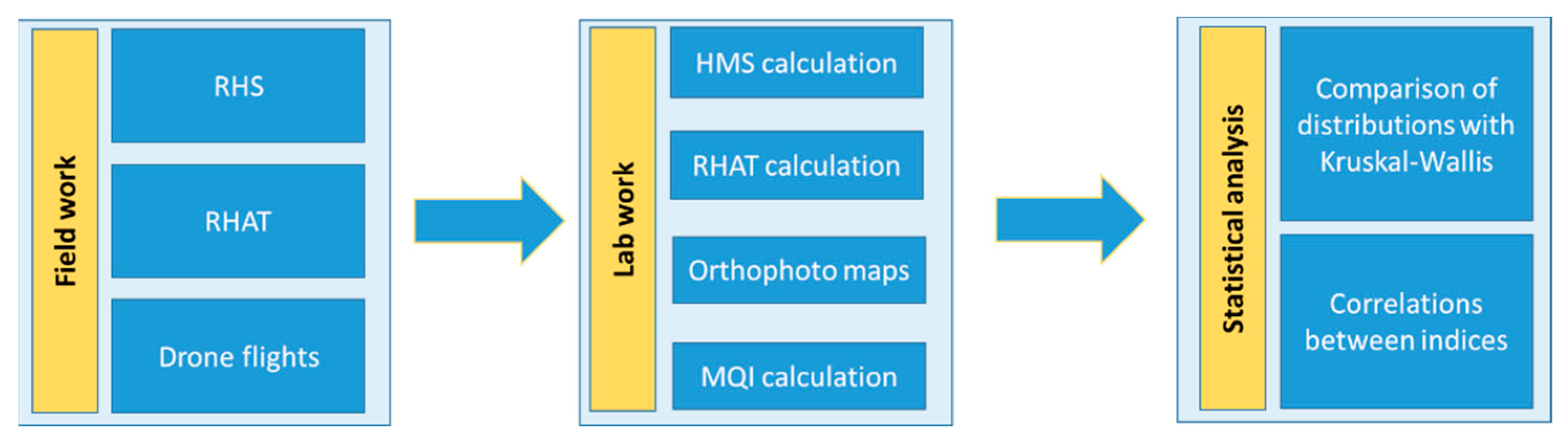
2. Materials and Methods

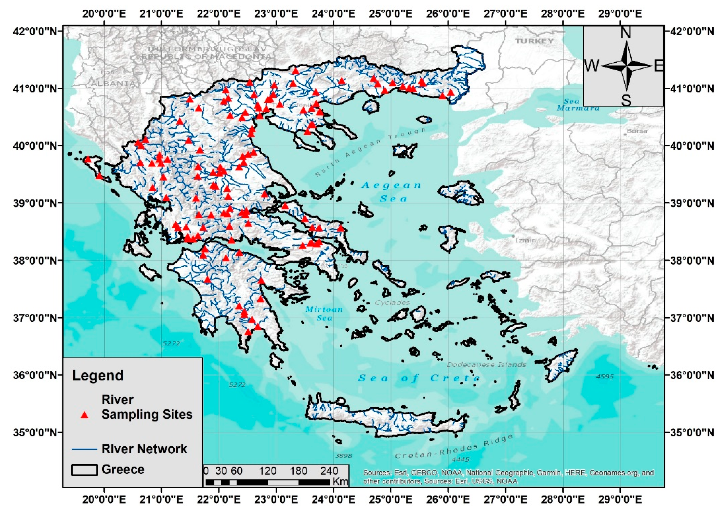
2.1. Description of the Study Area

Our study was conducted in 122 sites that are part of the Greek National Monitoring Program in compliance with the Water Framework Directive (WFD). Surveys were conducted during the summer periods of 2018, 2019, 2020 and 2021 when there was a typical low flow condition season for Mediterranean streams, which allows access in the channel of most streams and rivers [26]. The studied sites are distributed among 11 water districts (Epirus; Thessaly; Central, Eastern and Western Macedonia; Eastern, Northern and Western Peloponnese; Eastern and Western parts of Central Greece; Thrace) (Figure 1). The majority of the sites (46) belong to the Mediterranean intercalibration type (ICT) R-M2, which describes small to medium lowland Mediterranean streams. Twenty-four sites belong to the R-M5 type, defined as small lowland temporary streams with temporary flow. The remaining four ICTs—R-M1, small, medium-altitude Mediterranean streams with strong seasonal flow; R–M3, large Mediterranean streams with strong seasonal flow; R-M4, small to medium Mediterranean mountain streams with strong seasonal flow; and VL, very large rivers [20]—are represented by a smaller number of sites. Generally, the studied sites reflect a wide range of geomorphological characteristics and anthropogenic disturbance [20], as the share of agricultural land uses within the upstream catchment of each sites varies from 0% to 87%.

2.2. Hydromorphological Assessment Methods

We applied three different hydromorphological assessment methods: River Habitat Survey (RHS), which is the main hydromorphological assessment method of rivers in Greece according to the WFD, Morphological Quality Index (MQI) and River Hydromorphology Assessment Technique (RHAT). The RHAT was selected because the field survey and the protocol follow the RHS and can be easily applied in parallel. The MQI can be implemented with the use of aerial images and maps and thus, it does not require as much field work as the other two methods. Hence, both methods were implemented simultaneously with the RHS at a low cost and requiring little additional field labor by the surveyors. The main methodological stages of this study are illustrated in the flowchart of Figure 2. The RHS is based on filling a detailed field protocol during a survey of 10 equally spaced transects or “spot-checks” along a 500 m reach [6]. Multiple features of the channel, both banks and the riparian zone, are recorded. These features include types of substrate, types of flow, hydromorphological modifications, riparian vegetation structure, land use types and others. Furthermore, an overall assessment, called sweep-up, is conducted to collect additional information on features that were not recorded during the spot-checks. The filled protocols are then transferred to the River Habitat Survey Toolbox software, which calculates the Habitat Modification Score (HMS), a metric of the artificial modification of the reach. Based on the derived HMS, the sites are then categorized to five Habitat Modification Classes (Table 1). Here, for purposes of comparability, we matched these classes to the five quality classes defined by the WFD. A more analytical description of the method can be found in the articles by Raven et al. [6,27].
The MQI is a relatively new method developed for the hydromorphological assessment of Italian streams [7]. The method is WFD-compliant and it has been designed to be relatively simple to allow easy implementation by environmental agencies. It considers several aspects of a river system, such as continuity in sediment flux, bank erosion, lateral mobility and channel modifications, and it also accounts for historical changes in channel adjustments, which is an advantageous feature of the particular method compared to other assessments [7]. The implementation of the method requires a multi-step approach that involves the identification of physiographic units, the definition of confinement and morphological typologies and finally, the identification of homogeneous reaches where the index is applied and calculated. In our case, the river reaches have been previously defined, being part of the national monitoring network. Thus, the calculation of the index was conducted for all the 122 monitored sites along a 500 m reach, following the required identification of the confinement typology.
The RHAT is another WFD-compliant method that was developed after incorporating several features and components of the RHS for use in streams of the Republic of Ireland and Northern Ireland [28]. It can assess the hydromorphology of the water bodies using not only information from field studies but also from aerial photos, maps and historical data. The assessment requires a survey of 500 m reach, the same as the RHS, but it is based at least on a sweep-up (overall assessment) and at least two spot-check surveys.

2.3. Aerial Photography with the Use of Unmanned Aerial Vehicles (UAVs)

The use of unmanned aerial vehicles (UAVs) in ecological monitoring has gained ground as technological advances have reduced the operational costs and increased the level of output accuracy [29,30,31,32]. Here, in parallel with the field assessment, we used UAVs to produce high spatial resolution orthophoto maps of the studied reaches, which allowed us to collect additional information on key hydromorphological features. This enabled us to validate field observations and assess features that were not easily distinct in the field. The flight campaign was conducted at each site following the legislation regulations, using a DJI Mavic Pro UAV equipped with a 12 megapixel camera. The Pix4Dcapture software was used for flight planning with the single grid mission. A 500 m stretch of the surveyed length was captured with a width of 120 m to ensure that both the channel and the whole extent of the riparian zone were recorded. An 80% overlap rate of the images was selected, which resulted in approximately 110 to 240 photos per site. The Pix4Dmapper software (https://www.pix4d.com/ accessed on 27 January 2022) was used with photogrammetric algorithms to produce an orthophoto map. The map was then used complementary to filled-in protocols to validate field records and to collect additional information, especially in the case of the MQI and RHAT methods.

2.4. Statistical Analysis

Finally, we checked for significant differences in the hydromorphological classifications derived by each method among the six intercalibration types of rivers and the eleven water districts applying a Kruskal–Wallis test. The differences of the classifications among the three methods were also checked with a Kruskal–Wallis test. Kruskal–Wallis was used because it is a non-parametric test that assesses the significant differences of continuous and ordinal dependent variables between groups. Linear regressions between the values of the three indices were conducted in order to identify significant linear relationships. All statistical analyses and graphs were produced in R environment [33].

3. Results and Discussion

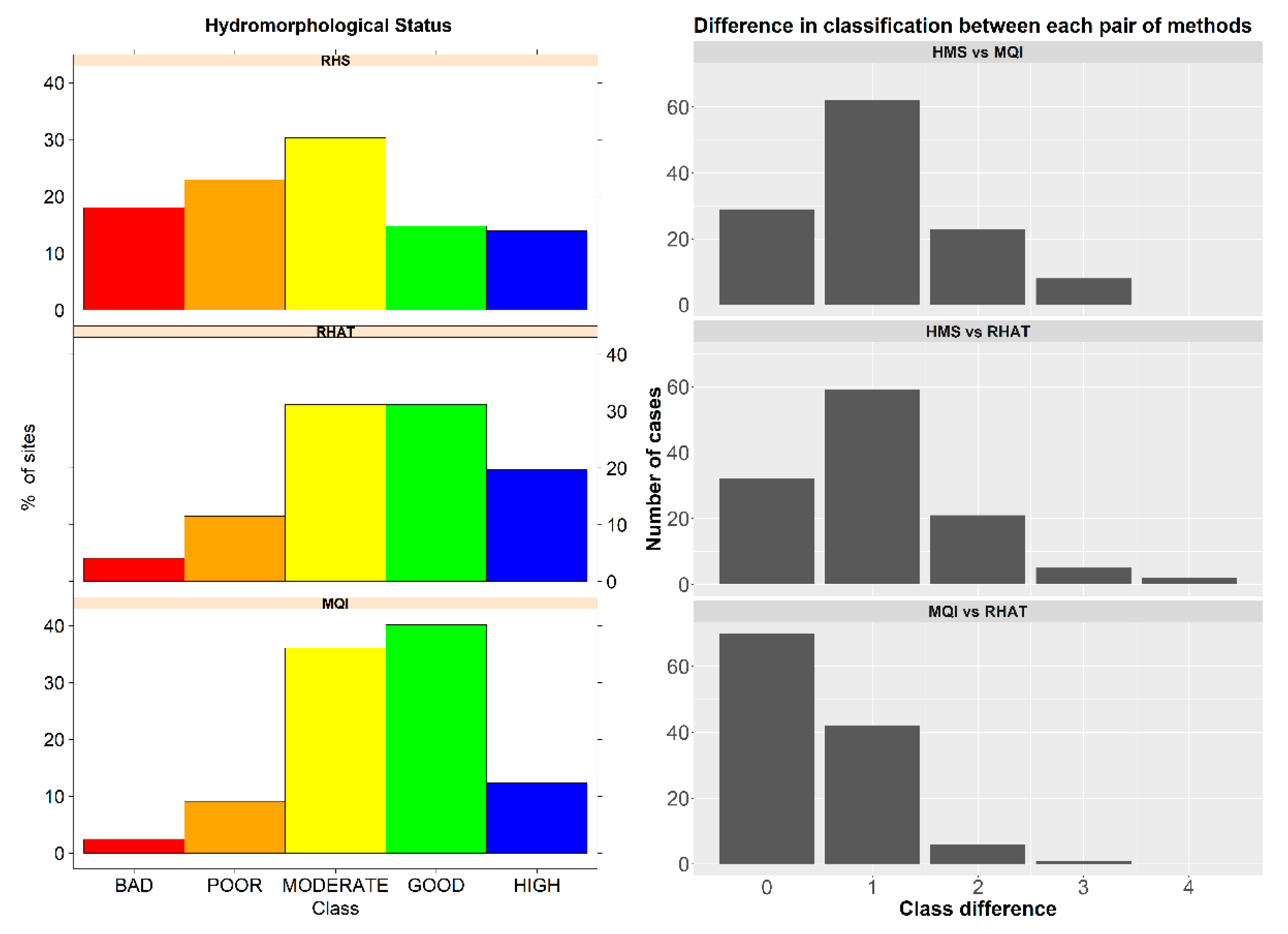
3.1. Overall Assessment of the Hydromorphological Status of the Studied Sites

The assessment of the hydromorphological status based on the calculation of the Habitat Modification Score showed that 28% of the sites had no or very low modifications, 30% were obviously modified and the remaining 42% were significant or severely modified. Concerning the assessment with the use of the MQI, almost 52% met the WFD requirements of at least “Good” status. Similarly, the share of the sites that were classified as “Good” or “High” according to the RHAT was approximately 51%. All indices have managed to highlight that hydromorphological alterations represent a serious problem, as 30% to 50% of the sites (depending on the method) met the WFD target. This is close to what we know from pan-European assessments that have reported hydromorphological stressors as the main causes for ecological degradation in many cases [11,12,34,35]. Figure 3 illustrates the distribution of the hydromorphological status among the five quality classes for each assessment method. It offers a first comparison between the three classification assessments, showing that there are some discrepancies and similarities concerning the results. First, the RHAT and the MQI methods seem to agree as they share a similar distribution pattern between the quality classes. Still, there are some obvious differences, as MQI classifies more sites as “Good” opposed to the RHAT, which classifies more sites as “High”. The classification based on the HMS is clearly stricter, meaning that a significant portion of the sites fall in the classes “Bad” and “Poor” (almost 42%), which leaves just 28% of the sites classified as “Good” and “High”. However, all three methods seem to agree when it comes to characterizing a site with “Moderate” status, as the percentages of sites that fall in this class are 30%, 36% and 31% for the RHS, MQI and RHAT methods, respectively. As a first remark, we should underline that the HMS is an index that is designed to classify river courses according to the degree of hydromorphological change, whereas the other two methods provide an overall assessment of the hydromorphological status. It is not unlikely that a classification based on the HQA would be similar to those derived by the RHAT and the MQI since the HQA focuses on the assessment of features and components and not on the hydromorphological alterations.
By further examining the differences between classes defined by each method and per site, we can see that the two methods that agree the most are MQI and RHAT, as 71 of the 122 sites are classified into the same quality class, and for 43 sites, the status differs by one class (Figure 3). The differences between RHS and the other two methods, MQI and RHAT, show that only 29 and 32 sites, respectively, share the same classification. For most cases, there is a difference by one quality class, although there is a considerably high number of cases that differ by two classes compared to the differences between the MQI and RHAT. Other studies that have compared the RHS with other methods have shown that the discrepancies between the methods vary. For instance, a recent study [17] showed that the RHS classification coincided with two other methods (QBR and HEM) for two-thirds of cases, which is a quite high percentage, but when compared with the LAWA method, the official hydromorphological assessment method used in Germany, there were similar assessments only for one-sixth of the cases.

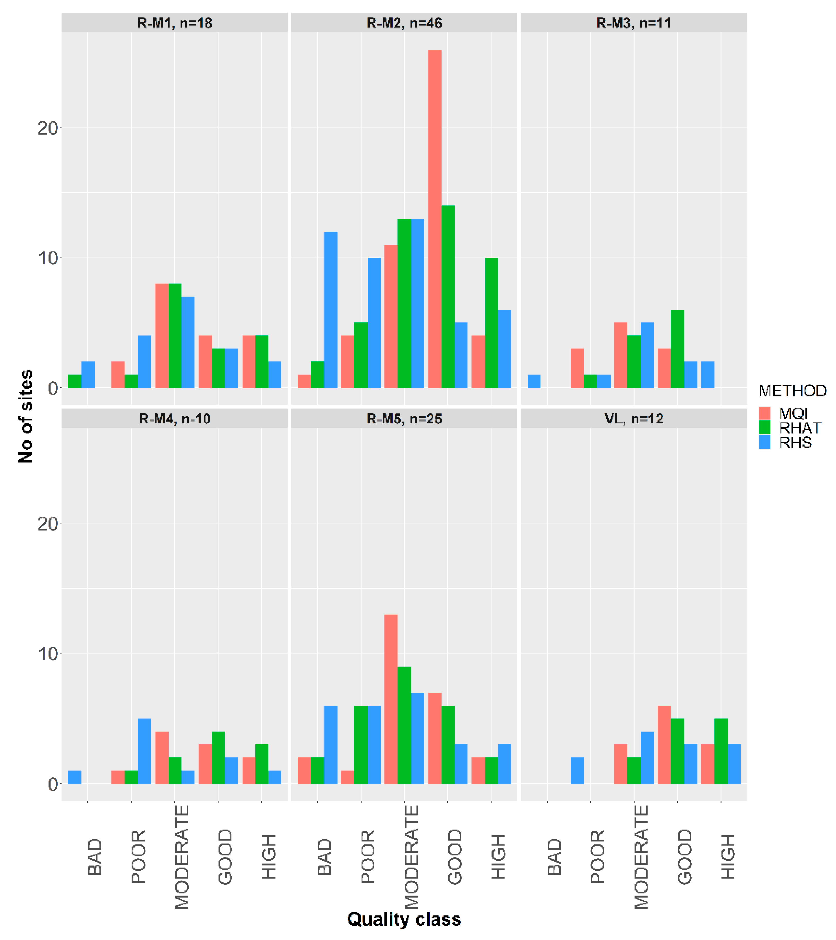
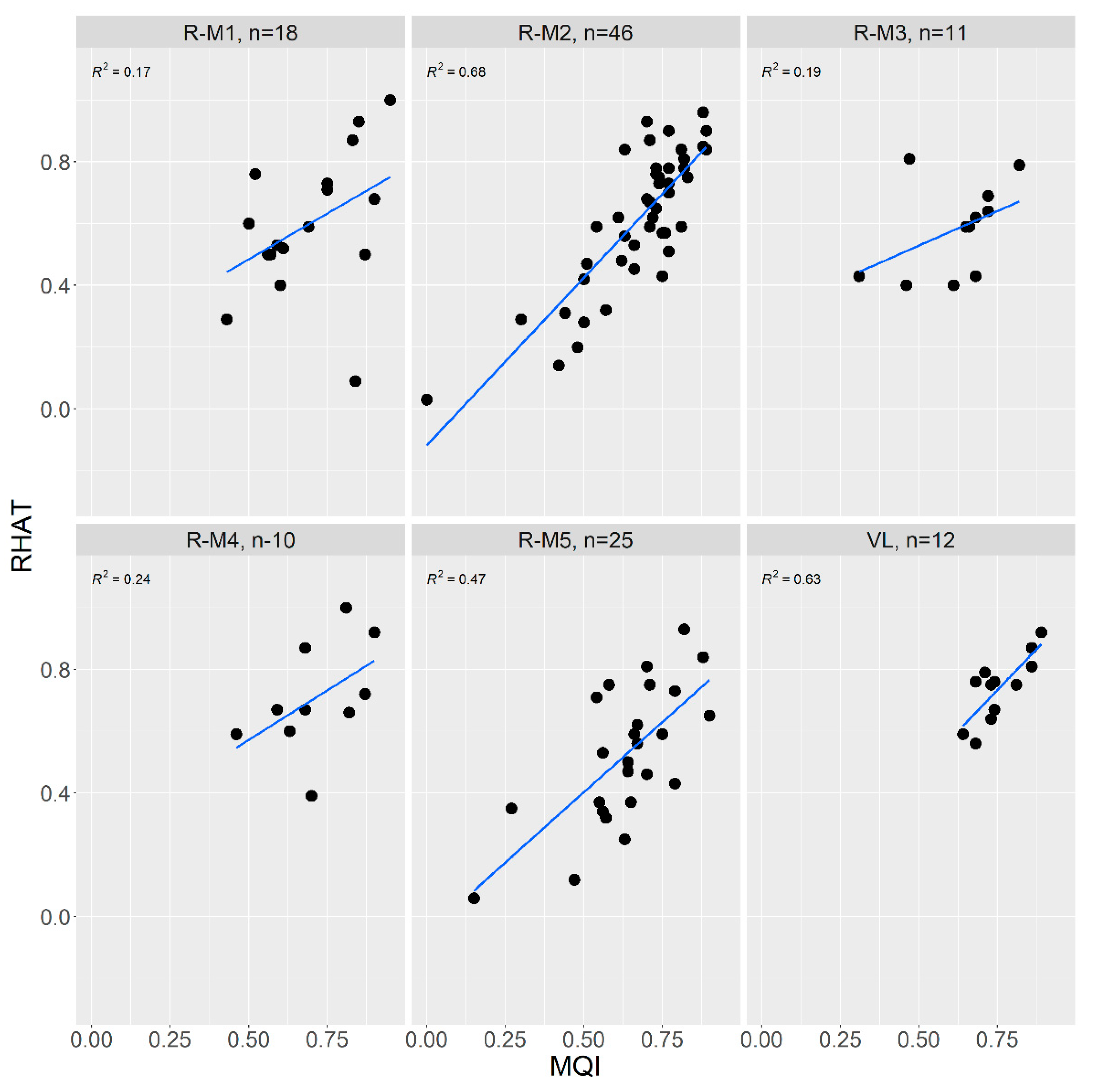
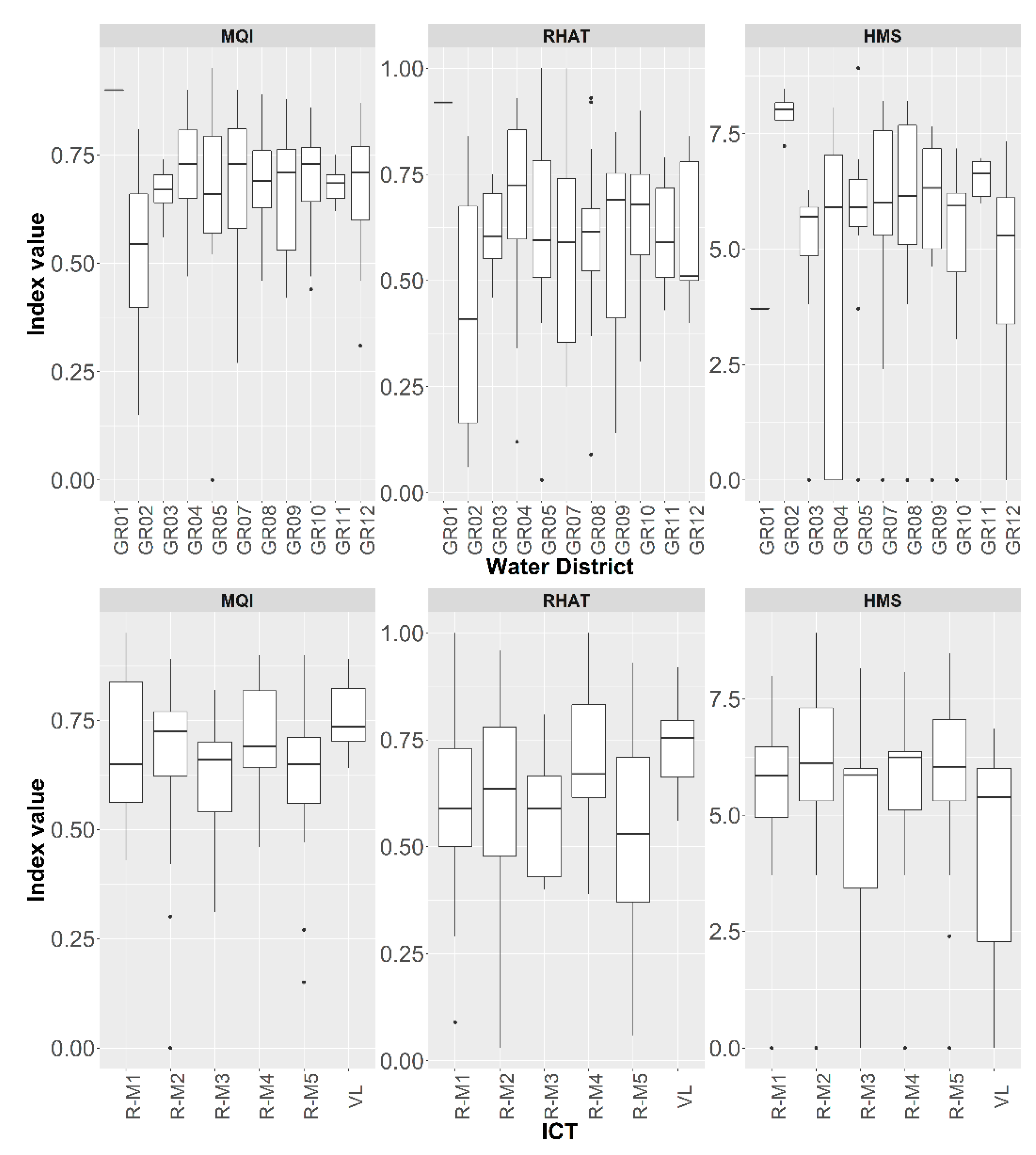
3.2. Comparative Assessment between Types of Water Bodies

In addition to the previous analysis, we explored whether the assessments from the three methods vary among the intercalibration river types (ICTs) that are used for the WFD river typology. Previous research has shown significant variations in the assessed hydromorphology of the Greek rivers among the six ICTs [20,21,26]. Here, we found that indeed there are differences of the hydromorphological assessment between the types, particularly for the RHAT and MQI methods (Table 2). For instance, the sites belonging to the very large rivers type (VL) have better hydromorphological status than other types, as indicated by the values of the MQI, RHAT and HMS (Figure 4). Differences also appear to exist in terms of geographic context, although these were not statistically significant. For instance, sites that are located in the Northern Peloponnese (GR02) appear to have worse hydromorphological status than other water districts. The reasons behind these differentiations have been already explored in previous studies [21] and are associated with the degree of human presence and intervention within the catchments and are mainly linked with the intensity of agricultural activity. For instance, channel and bank modifications may be related with flood protection measures for mitigating flood risk in agricultural catchments. Furthermore, small lowland streams (R-M2) may be more susceptible to hydromorphological pressures compared to larger rivers (VL). Nevertheless, what is important within the scope of the present study is to investigate if the different methods can capture these peculiarities that reflect the high variation in the hydromorphological status among typologies.
First, a Kruskal–Wallis test showed that there are significant differences between the hydromorphological classifications derived by the three methods (chi-squared = 26.354, p ≤ 0.001). By further examining the distribution of quality classes for each method and river type, we can distinguish where the methods yield to similar assessments. For example, in Figure 5, we can see that the distributions of the quality classes for the type R-M1 are similar regardless of the method. For the other types, there are some more obvious differences, mostly because the MQI seems to have higher densities around “Moderate” and “Good” classes (e.g., R-M2 and VL). This could imply a lack of sensitivity of the MQI at least for these types. Yet, both MQI and RHAT show similar distributions of quality classes for all 122 reaches, which could simply mean that both indices manage to adequately describe the actual hydromorphological status. HMS, on the other hand, classifies almost 40% of the sites as “Bad” and “Poor” quality. This could be explained because, as we mentioned previously, the HMS is an index of hydromorphological pressure, which takes account of all kinds of hydromorphological changes in channels and banks, and therefore, it identifies multiple aspects of hydromorphological modifications that may cause a reach to deviate from the natural or unmodified conditions (absence of modifications). In contrast, MQI and RHAT assess not only modifications but also physical processes and features that are expected to occur in undisturbed courses regardless of the observed level of disturbance. The practical implication of this variability between the different methods concerns the hydromorphological classification according to the WFD, as different methods may result in different quality classes. In our work, we noted that when using WFD-compliant methods that take into account both the hydromorphological features and pressures, the results are similar. Still, the observed variability among river types might indicate the need for a type-specific assessment, which can be achieved with the implementation of a full RHS, including the estimation of both HMS and HQA.
In the previous paragraph, we showed that MQI and RHAT assessment coincided for 71 sites. Linear regressions between the MQI and RHAT index for each ICT further showed that the two indices were strongly related for types R-M2 and VL (R2 0.68 and 0.63 respectively) (Figure 6). For types R-M1, R-M3 and R-M4, the two methods show little correlation, which means that they are more likely to yield different assessments. In practice, both methods show similar results for small lowland streams and very large rivers that are also low-altitude water bodies. In contrast, R-M1 and R-M4 water bodies are mid-altitude and mountainous streams, respectively, and as such are characterized by different hydromorphological conditions than the lowland courses. We consider that both RHAT and MQI may converge when it comes to assess lowland river courses, but not for streams and rivers of higher altitude.

3.3. Comparability of Methods—Strengths and Caveats

In general, our study showed that all methods can be applied sufficiently in most of the monitoring network sites. Here, we presented results obtained from the application of the method to a subset of the monitoring network (122 of the total 490 sites). Naturally, limitations with the application exist and they are related with the innate characteristics of each method. RHS and RHAT were originally developed for water bodies of the U.K. and Northern Ireland, respectively. Hence, the assessment of physical components, geomorphological features and hydromorphological alterations might overlook or underestimate conditions that are typical of streams and rivers of different geographic regions (e.g., Mediterranean). Particularly for the Mediterranean, where we encounter types of water bodies with unique characteristics, such as seasonal intermittency [36], the application of the RHS is related to difficulties mainly due to the seasonal flow variations and the dryness during the summer [37]. The results can vary depending on the period of year of sampling, as several features (e.g., macrophytes, mid-channel bars, flow types) may be absent during low flow or drought conditions. These issues can be resolved by adapting and modifying the RHS protocol to take account of the special natural characteristics of the assessed rivers [37,38]. In Italy, the CARAVAGGIO method [38] is a modified and extended version of the RHS, designed to deal with the unique features and characteristics of the Mediterranean streams, and is used for the assessment of the river habitats and in ecological studies [39]. However, any adjustment of the current methodology will require the development of a national RHS database that will sufficiently cover all the different river types and allow for the proper estimation of the Habitat Quality Assessment index. Another disadvantage is that the field survey is time-consuming compared to other methods, as it requires an extended record of features and modifications along a 500 m reach. Despite these impairments, we have to underline that the main components of the RHS, which are the HMS and HQA, offer a great advantage compared to other methods because they allow for a simultaneous assessment of the natural river characteristics and the extent of the modifications [17]. In our case, we used only the HMS index because the calculation of the HQA demands the presence of a national database that includes assessments of reference sites, which are sites with minimal or no hydromorphological modifications. As the compilation of this database is an ongoing process for the Greek monitoring program, we expect that the HQA will be available in a few years, by the end of the current monitoring phase. Nevertheless, this process is time-demanding and it requires extensive field work. These attributes might be considered as caveats (Table 3) that ultimately urge researchers and managers to seek alternative and less demanding methods in terms of time and effort.
The RHAT, although it is based on the RHS protocol and follows a similar assessment of features across a 500 m reach, offers a relatively quicker assessment of the overall hydromorphological status, providing an index value ranging from 0 to 1 and a WFD-compliant classification. Despite the limitations and the difficulties, which are mostly the same as those of the RHS, the RHAT classification was similar to the MQI, and the two indices were significantly correlated. Another advantage of the methods, and MQI, in particular, is that many of the assessment elements can be assessed with the use of high-quality orthophoto maps obtained with UAVs. This can be extremely advantageous in cases where access to the river is impossible or limited to a few meters along the reach [26]. Besides those cases with limited access, aerial photos can also provide information that is not easily obtainable with traditional field surveys, such as estimation of the river discharge [30], vegetation cover and types of substrates, combining high-quality aerial images and artificial neural networks for automated identification of features [40,41,42]. A couple of drawbacks concern the increased cost and the required expertise for flying drones along river reaches. Confined water courses, in particular, demand high expertise of drone surveying as the geology (deep valleys) and the dense vegetation may hamper the work of the drone operator. Furthermore, there are occasions when drone flights are not permitted (no-flight zones), such as when a river reach is close to an airport or a military camp. Table 2 summarizes the main differences and similarities of the three methods with emphasis placed on practical issues related to the implementation of each method (e.g., limitations due to restrained access to the river, advantages of using aerial images, etc.).
As a concluding remark, the estimation of the RHAT for the WFD classification of the sites can complement RHS, at least until a national database has been compiled, allowing the application of the HQA and a further classification of the riverine habitats, accounting for type-specific reference conditions.

4. Conclusions

We performed a comparative assessment of three different methods in rivers of Greece with the main objective to identify whether the RHAT and MQI methods can be successfully implemented complementary to RHS, resulting in similar results. In addition, we aimed to recognize possible strengths and caveats of each method that could be related to certain types of rivers. For instance, we found that the assessments seem to converge more for lowland courses compared to those located at middle or high altitudes. In general, RHAT and MQI classifications coincided for 71 out of 122 courses, and most of the remaining sites differed by only one class of hydromorphological status. Compared to the RHS classification, there were some notable differences, mainly because the HMS classified more sites as heavily modified by human disturbances (“Bad” and “Poor” quality classes), and less as undisturbed or affected by minor human influences (“High” quality status). Given the lack of a national RHS database, which is required for a proper habitat quality classification (HQA), we propose the use of alternative methods, which are easy and comprehensive to apply. The RHAT is an ideal complementary method to RHS and can offer a rather easy and quick assessment of the overall hydromorphological status in parallel with the RHS. Furthermore, it is worth investigating whether future implementation of the MQI can provide consistent assessments of hydromorphological status to additional reaches of our monitoring network. This will require the continuation of the current monitoring scheme and the complementary assessment with the MQI in order to collect a larger and more detailed dataset, including more records and observations from river types that were insufficiently represented in this study (e.g., river types R-M3, R-M4 and VL). Finally, a future study could compare these methods with the HQA to provide insight into whether the current assessment method needs to be revised or adapted for the next WFD monitoring phase.

Author Contributions

Conceptualization, K.S. and E.D.; methodology, K.S.; data curation, K.S., A.L., T.K., K.G. and E.D., formal analysis, K.S.; visualization, K.S. and G.P.; writing—original draft, K.S.; writing—review and editing, K.S., A.L., T.K., G.P., K.G. and E.D. All authors have read and agreed to the published version of the manuscript.

Funding

This research received no external funding.

Institutional Review Board Statement

Not applicable.

Data Availability Statement

Not applicable.

Conflicts of Interest

The authors declare no conflict of interest.

References

  1. European Commission Directive of the European Parliament and of the Council 2000/60/EC. Establishing a Framework for Community Action in the Field of Water Policy. Off. J. Eur. Parliam. 2000, L327, 1–82. [Google Scholar]
  2. European Topic Centre on Inland, Coastal and Marine Waters. Hydromorphological Alterations and Pressures in European Rivers, Lakes, Transitional and Coastal Waters; ETC/ICM: Prague, Czech Republic, 2012; Volume 2, ISBN 978-80-85087-98-7. [Google Scholar]
  3. Belletti, B.; Rinaldi, M.; Buijse, A.D.; Gurnell, A.M.; Mosselman, E. A review of assessment methods for river hydromorphology. Environ. Earth Sci. 2015, 73, 2079–2100. [Google Scholar] [CrossRef]
  4. Rinaldi, M.; Belletti, B.; Bussettini, M.; Comiti, F.; Golfieri, B.; Lastoria, B.; Marchese, E.; Nardi, L.; Surian, N. New tools for the hydromorphological assessment and monitoring of European streams. J. Environ. Manag. 2017, 202, 363–378. [Google Scholar] [CrossRef] [PubMed]
  5. Kamp, U.; Binder, W.; Hölzl, K. River habitat monitoring and assessment in Germany. Environ. Monit. Assess. 2007, 127, 209–226. [Google Scholar] [CrossRef] [PubMed]
  6. Raven, P.J.; Holmes, N.T.H.; Dawson, F.H.; Everard, M. Quality assessment using River Habitat Survey data. Aquat. Conserv. Mar. Freshw. Ecosyst. 1998, 8, 477–499. [Google Scholar] [CrossRef]
  7. Rinaldi, M.; Surian, N.; Comiti, F.; Bussettini, M. A method for the assessment and analysis of the hydromorphological condition of Italian streams: The Morphological Quality Index (MQI). Geomorphology 2013, 180–181, 96–108. [Google Scholar] [CrossRef]
  8. Bechter, T.; Baumann, K.; Birk, S.; Bolik, F.; Graf, W.; Pletterbauer, F. LaRiMo—A simple and efficient GIS-based approach for large-scale morphological assessment of large European rivers. Sci. Total Environ. 2018, 628–629, 1191–1199. [Google Scholar] [CrossRef]
  9. Knehtl, M.; Petkovska, V.; Urbanič, G. Is it time to eliminate field surveys from hydromorphological assessments of rivers?—Comparison between a field survey and a remote sensing approach. Ecohydrology 2018, 11, e1924. [Google Scholar] [CrossRef] [Green Version]
  10. González del Tánago, M.; Gurnell, A.M.; Belletti, B.; García de Jalón, D. Indicators of river system hydromorphological character and dynamics: Understanding current conditions and guiding sustainable river management. Aquat. Sci. 2016, 78, 35–55. [Google Scholar] [CrossRef]
  11. Grizzetti, B.; Pistocchi, A.; Liquete, C.; Udias, A.; Bouraoui, F.; Van De Bund, W. Human pressures and ecological status of European rivers. Sci. Rep. 2017, 7, 205. [Google Scholar] [CrossRef] [Green Version]
  12. Elosegi, A.; Sabater, S. Effects of hydromorphological impacts on river ecosystem functioning: A review and suggestions for assessing ecological impacts. Hydrobiologia 2013, 712, 129–143. [Google Scholar] [CrossRef]
  13. Poppe, M.; Kail, J.; Aroviita, J.; Stelmaszczyk, M.; Giełczewski, M.; Muhar, S. Assessing restoration effects on hydromorphology in European mid-sized rivers by key hydromorphological parameters. Hydrobiologia 2016, 769, 21–40. [Google Scholar] [CrossRef]
  14. Gellert, G.; Pottgiesser, T.; Euler, T. Assessment of the structural quality of streams in Germany—Basic description and current status. Environ. Monit. Assess. 2014, 186, 3365–3378. [Google Scholar] [CrossRef] [PubMed]
  15. Zaharia, L.; Ioana-Toroimac, G.; Moroşanu, G.A.; Gălie, A.C.; Moldoveanu, M.; Čanjevac, I.; Belleudy, P.; Plantak, M.; Buzjak, N.; Bočić, N.; et al. Review of national methodologies for rivers’ hydromorphological assessment: A comparative approach in France, Romania, and Croatia. J. Environ. Manag. 2018, 217, 735–746. [Google Scholar] [CrossRef] [PubMed]
  16. Šípek, V.; Matoušková, M.; Dvořák, M. Comparative analysis of selected hydromorphological assessment methods. Environ. Monit. Assess. 2010, 169, 309–319. [Google Scholar] [CrossRef] [PubMed]
  17. Wiatkowski, M.; Tomczyk, P. Comparative assessment of the hydromorphological status of the rivers Odra, Bystrzyca, and Ślȩza using the RHS, LAWA, QBR, and HEM methods above and below the hydropower plants. Water 2018, 10, 855. [Google Scholar] [CrossRef] [Green Version]
  18. Benjankar, R.; Koenig, F.; Tonina, D. Comparison of hydromorphological assessment methods: Application to the Boise River, USA. J. Hydrol. 2013, 492, 128–138. [Google Scholar] [CrossRef]
  19. Skoulikidis, N.T.; Karaouzas, I.; Amaxidis, Y.; Lazaridou, M. Impact of EU Environmental Policy Implementation on the Quality and Status of Greek Rivers. Water 2021, 13, 1858. [Google Scholar] [CrossRef]
  20. Stefanidis, K.; Papaioannou, G.; Markogianni, V.; Dimitriou, E. Water Quality and Hydromorphological Variability in Greek Rivers: A Nationwide Assessment with Implications for Management. Water 2019, 11, 1680. [Google Scholar] [CrossRef] [Green Version]
  21. Stefanidis, K.; Latsiou, A.; Kouvarda, T.; Lampou, A.; Kalaitzakis, N.; Gritzalis, K.; Dimitriou, E. Disentangling the Main Components of Hydromorphological Modifications at Reach Scale in Rivers of Greece. Hydrology 2020, 7, 22. [Google Scholar] [CrossRef] [Green Version]
  22. Szoszkiewicz, K.; Buffagni, A.; Davy-Bowker, J.; Lesny, J.; Chojnicki, B.H.; Zbierska, J.; Staniszewski, R.; Zgola, T. Occurrence and variability of River Habitat Survey features across Europe and the consequences for data collection and evaluation. Hydrobiologia 2006, 566, 267–280. [Google Scholar] [CrossRef]
  23. Stefanidis, K.; Oikonomou, A.; Papastergiadou, E. Responses of different facets of aquatic plant diversity along environmental gradients in Mediterranean streams: Results from rivers of Greece. J. Environ. Manag. 2021, 296, 113307. [Google Scholar] [CrossRef] [PubMed]
  24. Zieliński, P.; Suchowolec, T. Hydromorphological assessment of the anastomosing section of the Narew River after restoration. Limnol. Rev. 2013, 13, 51–59. [Google Scholar] [CrossRef]
  25. Naura, M.; Clark, M.J.; Sear, D.A.; Atkinson, P.M.; Hornby, D.D.; Kemp, P.; England, J.; Peirson, G.; Bromley, C.; Carter, M.G. Mapping habitat indices across river networks using spatial statistical modelling of River Habitat Survey data. Ecol. Indic. 2016, 66, 20–29. [Google Scholar] [CrossRef] [Green Version]
  26. Latsiou, A.; Kouvarda, T.; Stefanidis, K.; Papaioannou, G.; Gritzalis, K.; Dimitriou, E. Pressures and Status of the Riparian Vegetation in Greek Rivers: Overview and Preliminary Assessment. Hydrology 2021, 8, 55. [Google Scholar] [CrossRef]
  27. Raven, P.J.; Holmes, N.T.H.; Naura, M.; Dawson, F.H. Assessing the Ecological Integrity of Running Waters. Hydrobiologia 2000, 422, 359–367. [Google Scholar] [CrossRef]
  28. Toland, M.; Murphy, M. River Hydromorphology Assessment Technique (Rhat) Training Manual—Version 2; 2013; ISBN 978-1-907053-65-8. Available online: https://www.researchgate.net/publication/265914077_RIVER_HYDROMORPHOLOGY_ASSESSMENT_TECHNIQUE_RHAT_TRAINING_MANUAL_-VERSION_2 (accessed on 27 January 2022).
  29. Koutalakis, P.; Tzoraki, O.; Gkiatas, G.; Zaimes, G.N. Using uav to capture and record torrent bed and banks, flood debris, and riparian areas. Drones 2020, 4, 77. [Google Scholar] [CrossRef]
  30. Lagogiannis, S.; Dimitriou, E. Discharge estimation with the use of unmanned aerial vehicles (UAVs) and hydraulic methods in shallow rivers. Water 2021, 13, 2808. [Google Scholar] [CrossRef]
  31. Dimitriou, E.; Stavroulaki, E. Assessment of Riverine Morphology and Habitat Regime Using Unmanned Aerial Vehicles in a Mediterranean Environment. Pure Appl. Geophys. 2018, 175, 3247–3261. [Google Scholar] [CrossRef]
  32. Ourloglou, O.; Stefanidis, K.; Dimitriou, E. Assessing Nature-Based and Classical Engineering Solutions for Flood-Risk Reduction in Urban Streams. J. Ecol. Eng. 2020, 21, 46–56. [Google Scholar] [CrossRef]
  33. R Core Team. R: A Language and Environment for Statistical Computing; R Foundation for Statistical Computing: Vienna, Austria, 2022. [Google Scholar]
  34. Lemm, J.U.; Venohr, M.; Globevnik, L.; Stefanidis, K.; Panagopoulos, Y.; Gils, J.; Posthuma, L.; Kristensen, P.; Feld, C.K.; Mahnkopf, J.; et al. Multiple stressors determine river ecological status at the European scale: Towards an integrated understanding of river status deterioration. Glob. Change Biol. 2021, 27, 1962–1975. [Google Scholar] [CrossRef] [PubMed]
  35. Elosegi, A.; Díez, J.; Mutz, M. Effects of hydromorphological integrity on biodiversity and functioning of river ecosystems. Hydrobiologia 2010, 657, 199–215. [Google Scholar] [CrossRef]
  36. Feio, M.J.; Aguiar, F.C.; Almeida, S.F.P.; Ferreira, J.; Ferreira, M.T.; Elias, C.; Serra, S.R.Q.; Buffagni, A.; Cambra, J.; Chauvin, C.; et al. Least Disturbed Condition for European Mediterranean rivers. Sci. Total Environ. 2014, 476–477, 745–756. [Google Scholar] [CrossRef] [PubMed]
  37. Ferreira, J.; Pádua, J.; Hughes, S.J.; Cortes, R.M.; Varandas, S.; Holmes, N.; Raven, P. Adapting and adopting River Habitat Survey: Problems and solutions for fluvial hydromorphological assessment in Portugal. Limnetica 2011, 29, 263–272. [Google Scholar] [CrossRef]
  38. Buffagni, A.; Demartini, D.; Terranova, L. Manuale di Applicazione del Metodo CARAVAGGIO—Guida al Rilevamento e alla Descrizione degli Habitat Fluviali; CNR-IRSA: Rome, Italy, 2013; ISBN 978889765. [Google Scholar]
  39. Buffagni, A. The lentic and lotic characteristics of habitats determine the distribution of benthic macroinvertebrates in Mediterranean rivers. Freshw. Biol. 2021, 66, 13–34. [Google Scholar] [CrossRef]
  40. Casado, M.R.; Gonzalez, R.B.; Wright, R.; Bellamy, P. Quantifying the effect of aerial imagery resolution in automated hydromorphological river characterisation. Remote Sens. 2016, 8, 650. [Google Scholar] [CrossRef] [Green Version]
  41. Casado, M.R.; Gonzalez, R.B.; Kriechbaumer, T.; Veal, A. Automated identification of river hydromorphological features using UAV high resolution aerial imagery. Sensors 2015, 15, 27969–27989. [Google Scholar] [CrossRef] [Green Version]
  42. Rivas Casado, M.; González, R.B.; Ortega, J.F.; Leinster, P.; Wright, R. Towards a transferable UAV-based framework for river hydromorphological characterization. Sensors 2017, 17, 2210. [Google Scholar] [CrossRef] [Green Version]
Figure 1. Location of the 122 sampling sites where the three hydromorphological methods were applied.
Hydrology 09 00043 g001
Figure 2. Flowchart showing the main methodological steps followed in this study.
Hydrology 09 00043 g002
Figure 3. Distribution of hydromorphological quality class defined by each assessment method (left) and distribution of class difference between methods (right).
Hydrology 09 00043 g003
Figure 4. Box plots of MQI, RHAT and HMS per water district and intercalibration river type (ICT). HMS values have been ln transformed.
Hydrology 09 00043 g004
Figure 5. Distribution of quality classes defined by the three assessment methods for each intercalibration river type (ICT).
Hydrology 09 00043 g005
Figure 6. Linear regressions between RHAT and MQI indices per intercalibration river type (ICT). R2 value is shown on top left of each plot.
Hydrology 09 00043 g006
Table 1. Description of the five Habitat Modification Classes.
Habitat Modification ScoreHabitat Modification ClassDescription
0–161Pristine/semi-natural
17–1992Predominantly unmodified
200–4993Obviously modified
500–13994Significantly modified
>14005Severely modified
Table 2. Results of the Kruskal–Wallis rank sum test for the three assessment methods per ICT and water district. Values in bold are significant (p ≤ 0.1).
Classification MethodIntercalibration TypeWater District
Chi-Squaredp-ValueChi-Squaredp-Value
HMS7.8140.16715.8970.103
RHAT13.1320.0227.7880.649
MQI10.4840.0627.2080.706
Table 3. A comparison of the three methods currently used for hydromorphological assessment of rivers in Greece.
RHSRHATMQI
Length of assessed reach500 m500 mHomogeneous reach, usually few km
No of features elements assessed13 main features 8 attributes28 indicators
Assessment methodsField surveys Field surveys, GIS, mapsRemote sensing, GIS, maps, field surveys, aerial photos obtained by UAVs
OutputTwo synthetic indices, HMS and HQARHAT index (0–1) and WFD compliant quality classesMQI index (0–1) and WFD-compliant quality classes
StrengthsDetailed record of modifications and features in situ at local (e.g., transect) and reach scale with the estimation of the HMS
HQA provides a detailed overview of the habitat quality and diversity
Low cost
Detailed record of modifications and features in situ
Relatively easy estimation of the index value and quality classification Low cost
Allows the use of remote sensing products, e.g., aerial photos
Needs fewer adaptations to rivers of Greece
Easy estimation of the index and the quality classification
WeaknessesLimitations in conducting the 500 m survey to inaccessible and large deep rivers
Needs adaptations to water bodies from the Mediterranean region
Complex estimation of the indices HQA requires a national database of reference conditions
Field work is time-demanding
Limitations in conducting the 500 m survey to inaccessible and large deep rivers
Needs adaptations to water bodies from the Mediterranean region
It requires identification and characterization of the assessed reach with the use of GIS analysis
The identified homogeneous reach might be quite long (few km)It requires time-demanding work at office
Moderate cost if the usage of UAVs is considered
Requires expertise in drone surveying, if drones are used
Publisher’s Note: MDPI stays neutral with regard to jurisdictional claims in published maps and institutional affiliations.

