
Definition of Groundwater Management Zones for a Fissured Karst Aquifer in Semi-Arid Northeastern Brazil
 , , and
Abstract
1. Introduction

2. Materials and Methods
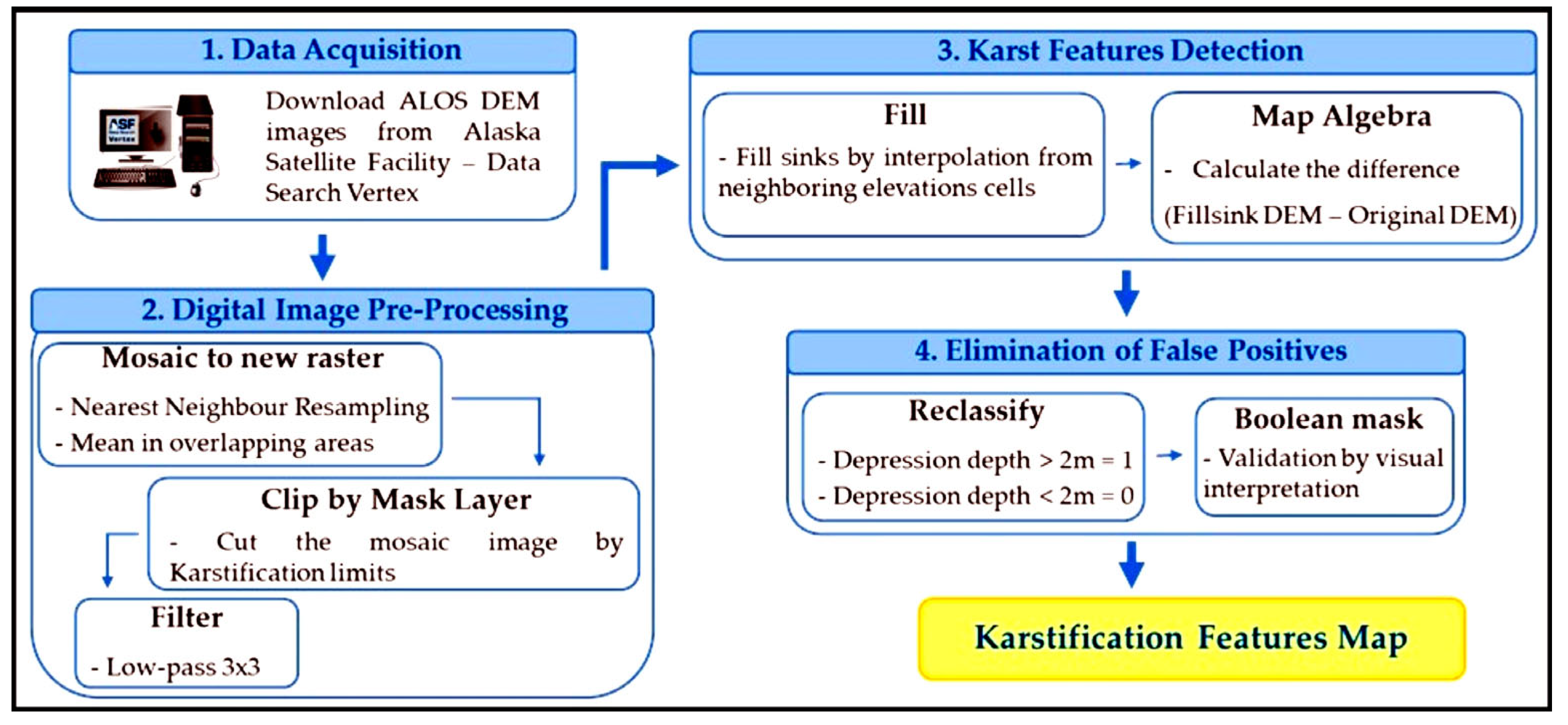
2.1. Karst Features
2.2. Land Use and Land Cover
2.3. Contamination
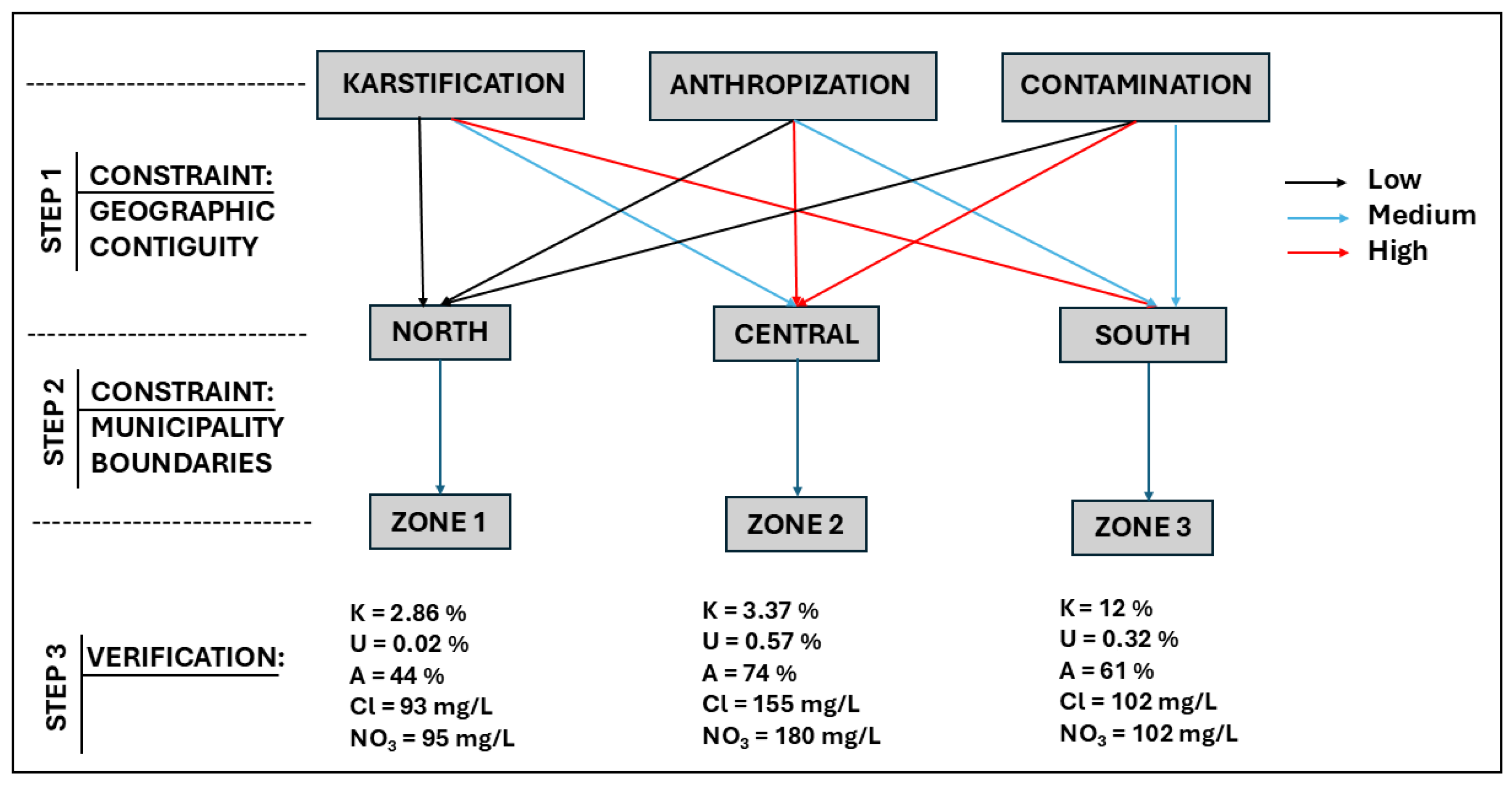
2.4. Zonification
3. Results and Discussion
3.1. Geographic, Climatic, and Geological Setting
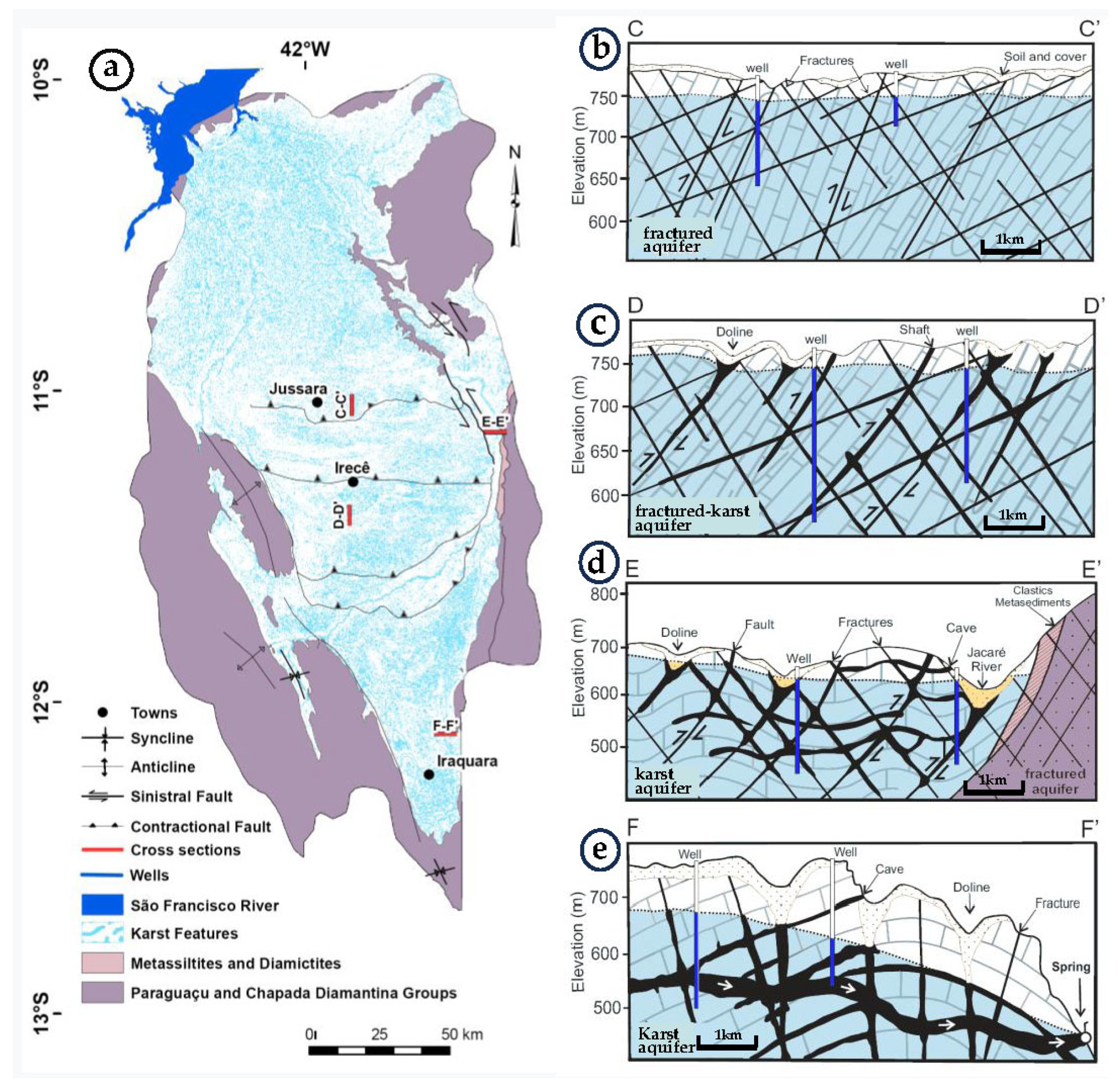
- The largest structural domain includes the northern and central part of the basin and is characterized by (a) subvertical beds and isoclinal folds with E-W axes, and (b) fractures with N40°/50°E and N40°/50°W directions (Figure 5b,c). The northern part has few documented karst features, such as springs, caves, and sinkholes, and is assumed to behave more like a fractured aquifer than a typical karst aquifer, although this may change with further mapping and study (Figure 5b). The central part of the aquifer has active karstification in the juvenile stage with a high density of narrow (5–10 m wide), elongated, E–W-oriented sinkholes and vertical sinkholes. Vertical sinkholes and elongated sinkholes concentrate aquifer recharge. They pose a serious geographic hazard to agricultural work and urbanization, while also putting the aquifer at risk of contamination.
- The second structural domain is located at the contact between Neoproterozoic carbonates and the older clastic metasediments of the Chapada Diamantina Group, around the edge of the karst basin. The carbonates overlie the metasediments in discordant contact and present a subhorizontal dip. The carbonates are cut by faults and fractures with N30°–40°W trends (Figure 5d). In this domain, karstification was formed by interformational groundwater flow from the underlying metasediments. Sinkholes and vertical depressions generally follow structural trends in this domain.
- The third structural domain to the south presents large folds, subhorizontal beds, long fractures with a predominant direction oriented N–S, and secondary fractures with directions of ~N15°W and N15°E (Figure 5e). Karstification is more developed in this area than in other parts of the aquifer. There is a high density of sinkholes of 100 m to 200 m in diameter, which typically follow N–S lineaments.
3.2. Hydrogeological and Hydrochemical Conditions
3.3. Land Use, Management Zones, and Strategies
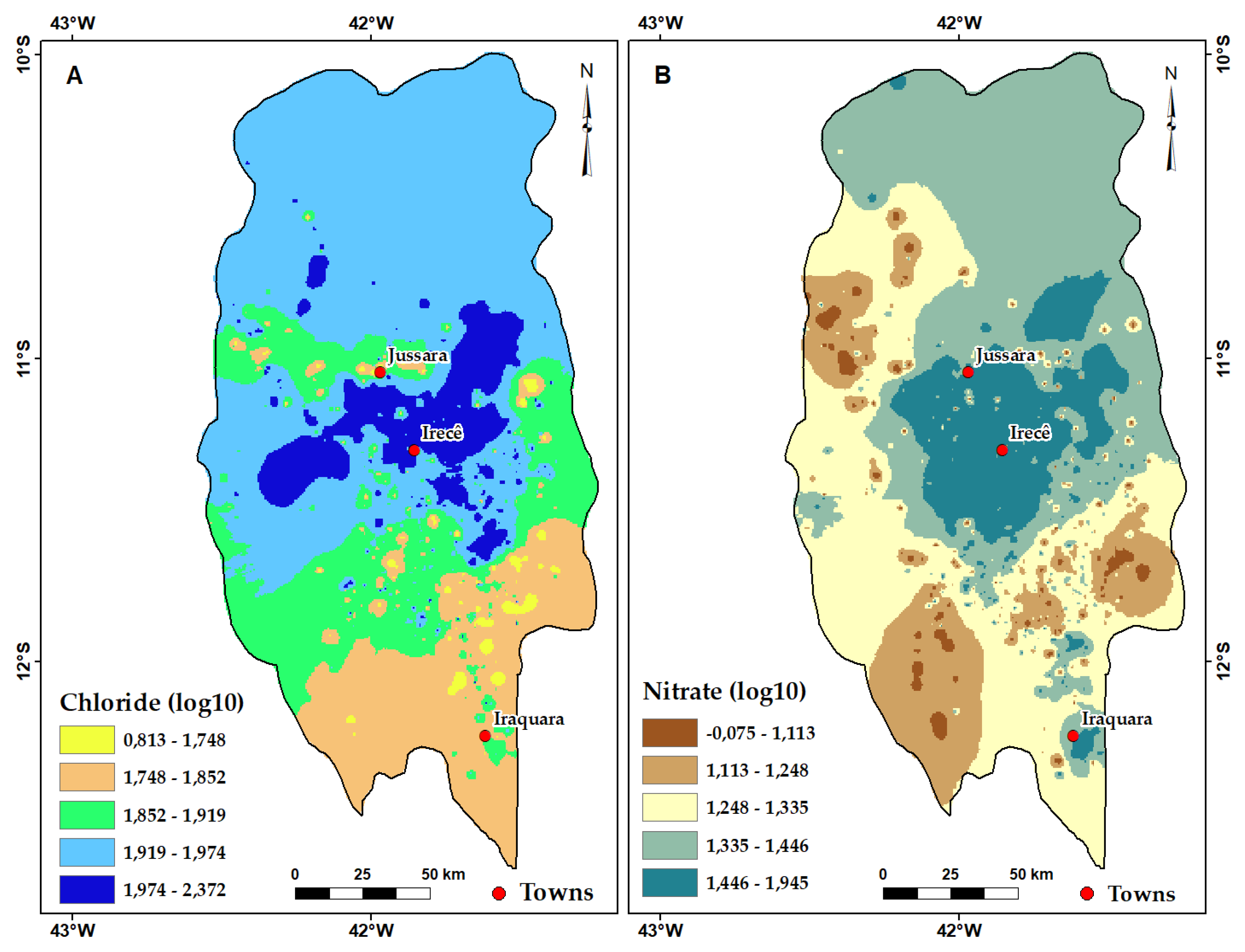
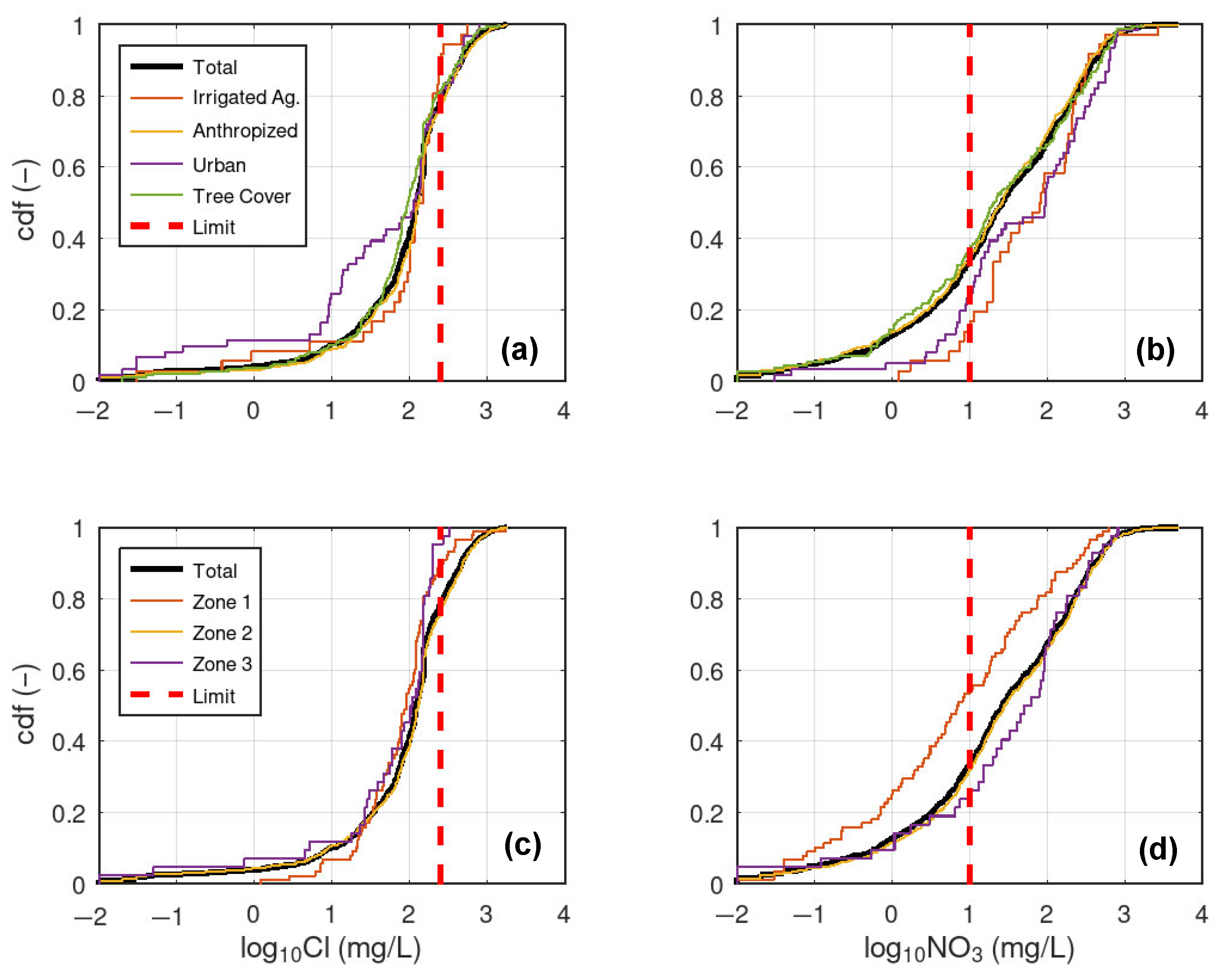
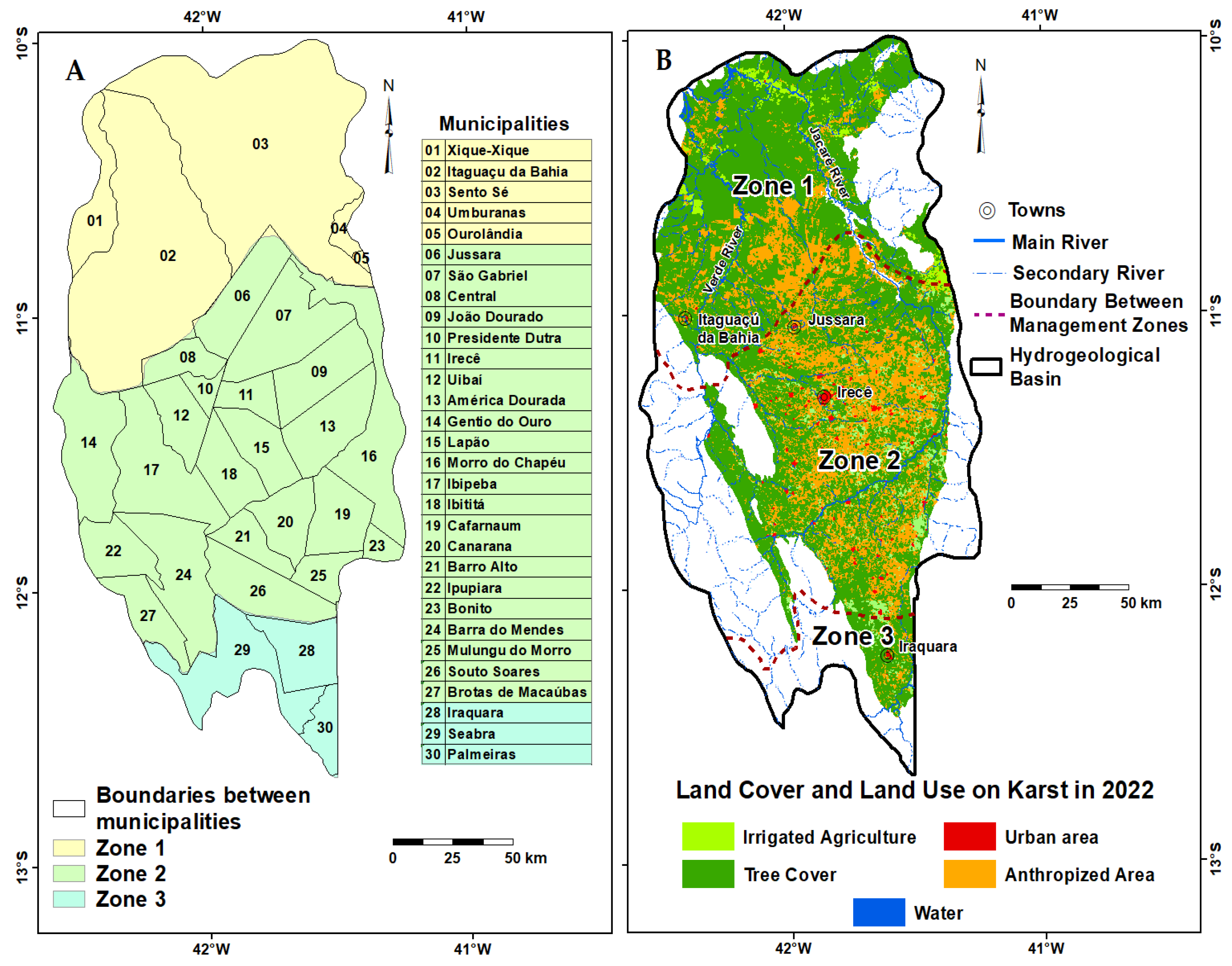
- Management zone 1 is located in the northern part of the basin, where the fissured karst aquifer is overlain by Cenozoic colluvial and river valley deposits. The aquifer shows less evident karstification in this area than in others. This zone currently has a lower population density, low agricultural activity (Table 3), and less groundwater exploitation than the other zones. Due to these factors, it appears to have less potential for contamination of groundwater resources than the other zones. Future urbanization and other developments, however, will require additional safeguards, including management strategies to minimize environmental degradation. Figure 6 shows a region in the west of management zone 1 with high concentrations for chloride, but low ones for nitrate. This can be explained by the fact that this is a small agricultural area on the banks of the Rio Verde, where the use of chloride-based agricultural inputs probably occurs more frequently. Among the most common substances are potassium chloride, widely used as fertilizer, ammonium chloride, as well as pesticides and herbicides containing chlorinated compounds, which are still used in the region. In general, the highest nitrate concentrations are associated with urban areas and, because there is low urbanization in this area, this is reflected in the low nitrate concentrations.
- Management zone 2 is in the central part of the aquifer, where karstification is well developed, the soils are thin, and the potentiometric surface is flat. In this zone, however, urbanization has been accelerating, increasing the development of irrigated agriculture and intensive use of groundwater. Although development and growth have brought great social and economic benefits, there have also been problems with unsustainable reductions in available water resources and increases in Cl and NO3 concentrations.
- Management zone 3 is located in the extreme south of the Irecê basin and presents karstification in a mature stage. The conduits are well developed, and the groundwater discharge to the springs is turbulent. The potentiometric surface is at a greater depth below the ground surface than in management zones 1 and 2. Few wells have been drilled to date. This zone has many caves and beautiful springs. Accessible caves are being made available as ecotourism attractions, both for the general public and for speleological studies. It is a zone that is very vulnerable to groundwater contamination. In terms of groundwater contamination within the three management zones (Figure 7c,d), there is a rather slight differentiation for chloride in that the MRL is exceeded more frequently in zone 2 (20%) than in zones 1 (10%) and 3 (5%). For nitrate, there is a stronger distinction, with zone 3 having the worst (75%) exceedance of the MRL, followed by zones 2 (65%) and 1 (45%). However, the difference between zones 2 and 3 is rather small and the average nitrate concentration in zone 3 is still lower than in zone 2 (Figure 4). Although zone 3 has a lower degree of urbanization, there is a high level of karstification and, hence, vulnerability, which may lead to an elevated groundwater contamination.
3.4. Future Work and Recommendations
- Control unsustainable depletion of the aquifer by issuing permits to regulate well drilling, while requiring measurement and reporting of groundwater abstraction;
- Build sewage and wastewater collection systems and use improved standards for designing and operations at solid waste disposal sites;
- Prohibit direct or indirect disposal of untreated liquid and solid waste underground;
- Prohibit or restrict the storage, use, and transportation of hazardous and toxic materials, including underground storage tanks for combustible hydrocarbons, in sensitive aquifer recharge areas;
- Develop rules and policies for urban development, with planning for the location and construction of housing, buildings, public facilities, industrial facilities, and roads;
- Conduct a variety of public education campaigns to raise awareness of the fissured karst aquifer and build community support for management strategies.
4. Conclusions
Author Contributions
Funding
Data Availability Statement
Acknowledgments
Conflicts of Interest
References
- Hao, Y.; Yeh, T.J.; Hu, C.; Wang, Y.; Li, X. Karst groundwater management by defining protection zones based on regional geological structures and groundwater flow fields. Environ. Geol. 2006, 50, 415–422. [Google Scholar] [CrossRef]
- Ford, D.; Williams, P.D. Karst Hydrogeology and Geomorphology; John Wiley & Sons: Hoboken, NJ, USA, 2007. [Google Scholar]
- Kalhor, K.; Ghasemizadeh, R.; Rajic, L.; Alshawabkeh, A. Assessment of groundwater quality and remediation in karst aquifers: A review. Groundw. Sustain. Dev. 2019, 8, 104–121. [Google Scholar] [CrossRef] [PubMed]
- Chen, Z.; Hartmann, A.; Wagener, T.; Goldscheider, N. Dynamics of water fluxes and storages in an Alpine karst catchment under current and potential future climate conditions. Hydrol. Earth Syst. Sci. 2018, 22, 3807–3823. [Google Scholar] [CrossRef]
- Auler, A.; Farrant, A.R. A brief introduction to karst and caves in Brazil. Proc. Univ. Bristol Spelaeol. Soc. 1996, 20, 187–200. [Google Scholar]
- Oliveira, I.B.; Negrão, F.I.; Silva, A.G.L.S. Aquifer mapping in the state of Bahia using the natural groundwater quality index–IQNAS. Águas Subterrâneas 2007, 21, 123–137. [Google Scholar]
- Quinn, J.J.; David, T.; James, A.K. Modeling complex flow in a karst aquifer. Sediment. Geol. 2006, 184, 343–351. [Google Scholar] [CrossRef]
- White, W.B. Karst hydrology: Recent developments and open questions. Eng. Geol. 2002, 65, 85–105. [Google Scholar] [CrossRef]
- Lucon, T.N.; Costa, A.T.; Galvão, P.; Leite, M.G.P.; Madeira, T.; Nogueira, L.B. Recharge sources and hydraulic communication of karst aquifer, São Miguel watershed, MG, Brazil. J. South Am. Earth Sci. 2020, 100, 102591. [Google Scholar] [CrossRef]
- Chen, Z.; Auler, A.S.; Bakalowicz, M.; Drew, D.; Griger, F.; Hartmann, J.; Goldscheider, N. The World Karst Aquifer Mapping project: Concept, mapping procedure and map of Europe. Hydrogeol. J. 2017, 25, 771. [Google Scholar] [CrossRef]
- LeGrand, H.E.; Stringfield, V.T. Karst hydrology—A review. J. Hydrol. 1973, 20, 97–120. [Google Scholar] [CrossRef]
- Wang, J.; Huang, J.; Blanke, A.; Huang, Q.; Rozelle, S. The development, challenges and management of groundwater in rural China. In The Agricultural Groundwater Revolution: Opportunities and Threats to Development; CAB International: Oxfordshire, UK, 2007; pp. 37–62. [Google Scholar]
- Bakalowicz, M. Karst groundwater: A challenge for new resources. Hydrogeol. J. 2005, 13, 148–160. [Google Scholar] [CrossRef]
- Kresic, N.; Stevanovic, Z. Groundwater Hydrology of Springs: Engineering, Theory. Management, and Sustainability; Elsevier: Amsterdam, The Netherlands, 2010. [Google Scholar]
- Bystriakova, N.; Alves de Melo, P.H.; Moat, J.; Lughadha, E.N.; Monro, A.K. A preliminary evaluation of the karst flora of Brazil using collections data. Sci. Rep. 2019, 9, 17037. [Google Scholar] [CrossRef] [PubMed]
- Masilela, M.; Beckedahl, H. Karst geomorphology and related environmental problems in Southern Africa–A review. J. Afr. Earth Sci. 2022, 196, 104686. [Google Scholar] [CrossRef]
- Qian, J.; Zhan, H.; Wu, Y.; Li, F.; Wang, J. Fractured-karst spring-flow protections: A case study in Jinan, China. Hydrogeol. J. 2006, 14, 1192–1205. [Google Scholar] [CrossRef]
- Ji, H.; Chiogna, G.; Chang, W.; Richieri, B.; Chen, L.; Luo, M.; Guo, X.; Huang, K. Investigating the structure of a multiple karst aquifer system and its hydrological process response using high-resolution multi-tracer data. J. Hydrol. 2025, 657, 133152. [Google Scholar] [CrossRef]
- Biondić, B.; Biondić, R.; Dukarić, F. Protection of karst aquifers in Dinardes in Croatia. Environ. Geol. 1998, 34, 309–319. [Google Scholar]
- Panagopoulos, G.; Lambrakis, N. The contribution of time series analysis to the study of the hydrodynamic characteristics of the karst systems: Application on two typical karst aquifers of Greece (Trifilia, Almyros Crete). J. Hydrol. 2006, 25, 25–34. [Google Scholar] [CrossRef]
- Sauro, U. Human impact on the karst of the Venetian forealps, Italy. Environ. Geol. 1993, 21, 115–121. [Google Scholar] [CrossRef]
- Oraseanu, I.; Mather, J. Karst hydrogeology and origin of thermal waters in Codru Moma Mountains, Romania. Hydrogeol. J. 2000, 8, 379–398. [Google Scholar] [CrossRef]
- Kattan, Z. Environmental isotope study of the major karst springs in Damascus limestone aquifer system: Case of the Figeh and Barada Springs. J. Hydrol. 1997, 193, 161–181. [Google Scholar] [CrossRef]
- Vaute, L.; Drogue, C.L.; Garrelly, M. Ghelfenstein. Relations between the structure of storage and the transport of chemical compounds in karstic aquifers. J. Hydrol. 1997, 199, 221–238. [Google Scholar] [CrossRef]
- Bastos Leal, L.R.; Silva, H.P. Hydrologic model and management of the aquifer river system on the Verde and Jacaré Rivers–Semi-arid region of the Bahia State, Brazil. Final Technical Report of the contract 002/2002 SRH/UFBA. 2004; Unpublished. (In Portuguese) [Google Scholar]
- Gonçalves, M.J.D.S. Risk Assessment of Contamination of the Karst Fissural Aquifer in Irece-Bahia Region. Master’s Dissertation, Federal University of Bahia, Institute of Geosciences, Salvador, Brazil, 2004; 121p. [Google Scholar]
- Bastos Leal, L.R.; Dutton, A.R.; Luz, J.A.G.; Barbosa, J.S.F. Hydrogeology and hydrochemistry of a Precambrian karst aquifer in a semi-arid region from Bahia, Brazil. In Proceedings of the Philadelphia Annual Meeting, Philadelphia, PA, USA, 22–25 October 2006; Geological Society of America: Boulder, CO, USA, 2006; Volume 38, p. 286. [Google Scholar]
- Pardo-Igúzquiza, E.; Valsero, J.J.D.; Dowd, P.A. Automatic detection and delineation of karst terrain depressions and its application in geomorphological mapping and morphometric analysis. Acta. Carsologica 2013, 42, 17–24. [Google Scholar] [CrossRef]
- Carvalho Júnior, O.A.; Guimarães, R.F.; Montgomery, D.R.; Gillespie, A.R.; Gomes, R.A.T.; Martins, E.S.; Silva, N.C. Karst Depression Detection Using ASTER, ALOS/PRISM and SRTM-Derived Digital Elevation Models in the Bambuí Group, Brazil. Remote Sens. 2014, 6, 330–351. [Google Scholar] [CrossRef]
- Wulder, M.A.; Masek, J.G.; Cohen, W.B.; Loveland, T.R.; Woodcock, C.E. Opening the archive: How free data has enabled the science and monitoring promise of Landsat. Remote Sens. Environ. 2012, 122, 2–10. [Google Scholar] [CrossRef]
- Gorelick, N.; Hancher, M.; Dixon, M.; Ilyushchenko, S.; Thau, D.; Moore, R. Google Earth Engine: Planetary-scale geospatial analysis for everyone. Remote Sens. Environ. 2016, 202, 18–27. [Google Scholar] [CrossRef]
- Souza, C.M., Jr.; Shimbo, Z.J.; Rosa, M.R.; Parente, L.L.; Alencar, A.A.; Rudorff, B.F.T.; Hasenack, H.; Matsumoto, M.G.; Ferreira, L.; Souza-Filho, P.W.M. Reconstructing three decades of Land Use and Land Cover changes in Brazilian Biomes with Landsat archive and Earth Engine. Remote Sens. 2020, 12, 2735. [Google Scholar] [CrossRef]
- SIAGAS/Serviço Geológico Brasileiro. Available online: https://siagasweb.sgb.gov.br/layout/ (accessed on 15 June 2023).
- Pebesma, E. Simple Features for R: Standardized Support for Spatial Vector Data. 2018. Available online: https://cran.r-project.org/web/packages/sf/sf.pdf (accessed on 27 May 2024).
- Pebesma, E.; Bivand, R.S. Classes and Methods for Spatial Data in R. 2005. Available online: https://cran.r-project.org/web/packages/sp/sp.pdf (accessed on 27 May 2024).
- Pebesma, E. Multivariable Geostatistics in S: The Gstat Package. 2004. Available online: https://cran.r-project.org/web/packages/gstat/gstat.pdf (accessed on 27 May 2024). [CrossRef]
- Hijmans, R.J. Raster: Geographic Data Analysis and Modeling. 2023. Available online: https://cran.r-project.org/web/packages/raster/raster.pdf (accessed on 27 May 2024).
- Beraldo, V.J. Environmental Isotopic and Hydrochemical Study of the Surface and Groundwater of the Irece Region, Bahia. Master’s Thesis, Federal University of Bahia, Salvador, Brazil, 2005. (In Portuguese). [Google Scholar]
- Ramos, S.O.; Araújo, H.A.D.; Leal, L.R.B.; Luz, J.A.G.D.; Dutton, A.R. Temporal Variation of the Water Table in the Karst Aquifer of Irecê-Bahia: Contribution to the Use and Management of Groundwater in the Semi-Arid Region. Rev. Bras. De Geociências 2007, 37, 227–233. (In Portuguese) [Google Scholar] [CrossRef]
- Gonçalves, T.S.; Bastos Leal, L.R. Water potential in the Salitre Karst Aquifer in Irece region, Bahia. Rev. Águas Subterrâneas 2018, 32, 191–199. (In Portuguese) [Google Scholar] [CrossRef]
- Misi, A.; Veizer, J. Neoproterozoic carbonate sequences of the Una Group, Irece Basin, Brazil: Chemostratigraphy, age and correlations. Precambrian Res. 1998, 89, 87–100. [Google Scholar] [CrossRef]
- Gonçalves, T.S.; Klammler, H.; Bastos Leal, L.R. Geospatial Analysis of Transmissivity and Uncertainty in a Semi-Arid Karst Region. Water 2024, 16, 780. [Google Scholar] [CrossRef]
- Gonçalves, T.S.; Klammler, H.; Bastos Leal, L.R.; Salles, L.Q. Multivariate Geostatistics for Mapping of Transmissivity and Uncertainty in Karst Aquifers. Water 2024, 16, 2430. [Google Scholar] [CrossRef]
- Guerra, A.M. Karstification Process and Hydrogeology of the Bambui Group in the Irece Region, Bahia. Ph.D. Thesis, University of São Paulo, São Paulo, Brazil, 1986. (In Portuguese). [Google Scholar]
- Bedmar, A.P.; Silva, A.B.; Jardim, F.G.; Oliveira, L.B. Contribution of the environmental isotopic in the study of the karst aquifer in central part of Bahia State, Brazil. Rev. Bras. Geociências 1980, 10, 104–116. (In Portuguese) [Google Scholar]
- Santos, E.S.M.; Silva, R.W.; Sampaio, E.E.S. Analysis of the risk of karst collapse in Lapão, Bahia, Brazil. Explor. Geophys. 2012, 43, 198–212. [Google Scholar] [CrossRef]
- Salles, L.Q.; Galvão, P.; Bastos Leal, L.R.; De Araujo Pereira, R.G.F.; Purificação, C.G.C.; Laureano, F.V. Evaluation of Susceptibility for Terrain Collapse and Subsidence in Karst Areas, Municipality of Iraquara, Chapada Diamantina (BA), Brazil. Environ. Earth Sci. 2018, 77, 593. [Google Scholar] [CrossRef]


| Class | Description |
|---|---|
| Tree cover Water | Natural vegetation cover Perennial or intermittent rivers and water bodies |
| Irrigated agriculture | Annual and perennial crops |
| Anthropized area | Pasture areas, natural or planted, related to farming activity, and farming areas where it was not possible to distinguish between pasture and agriculture |
| Urban area | Urban areas with a predominance of non-vegetated surfaces, including roads, highways, and constructions |
| Domain | Parameter | Mean | Median | Min. 1 | Max. 2 | N 3 |
|---|---|---|---|---|---|---|
| Northern | Chloride | 93 | 80 | 0.01 | 661 | 88 |
| Central | Chloride | 155 | 102 | 0.01 | 1788 | 782 |
| Southern | Chloride | 102 | 100 | 0.01 | 329 | 42 |
| Northern | Nitrate | 95 | 33 | 0.01 | 620 | 88 |
| Central | Nitrate | 180 | 66 | 0.01 | 4.800 | 782 |
| Southern | Nitrate | 102 | 26 | 0.01 | 810 | 42 |
| Management Zone | Irrigated Agriculture | Tree Cover | Anthropized Area | Water | Urban Area |
|---|---|---|---|---|---|
| Zone 1 | 1.5 | 54.1 | 44.1 | 0.31 | 0.02 |
| Zone 2 | 1.8 | 23.1 | 74.4 | 0.04 | 0.57 |
| Zone 3 | 1.6 | 37.3 | 60.8 | 0.01 | 0.32 |
Disclaimer/Publisher’s Note: The statements, opinions and data contained in all publications are solely those of the individual author(s) and contributor(s) and not of MDPI and/or the editor(s). MDPI and/or the editor(s) disclaim responsibility for any injury to people or property resulting from any ideas, methods, instructions or products referred to in the content. |
© 2025 by the authors. Licensee MDPI, Basel, Switzerland. This article is an open access article distributed under the terms and conditions of the Creative Commons Attribution (CC BY) license (https://creativecommons.org/licenses/by/4.0/).
Share and Cite
Silva, H.M.d.; Leal, L.R.B.; Filho, C.A.T.F.; Gonçalves, T.d.S.; Klammler, H. Definition of Groundwater Management Zones for a Fissured Karst Aquifer in Semi-Arid Northeastern Brazil. Hydrology 2025, 12, 195. https://doi.org/10.3390/hydrology12080195
Silva HMd, Leal LRB, Filho CATF, Gonçalves TdS, Klammler H. Definition of Groundwater Management Zones for a Fissured Karst Aquifer in Semi-Arid Northeastern Brazil. Hydrology. 2025; 12(8):195. https://doi.org/10.3390/hydrology12080195
Chicago/Turabian StyleSilva, Hailton Mello da, Luiz Rogério Bastos Leal, Cezar Augusto Teixeira Falcão Filho, Thiago dos Santos Gonçalves, and Harald Klammler. 2025. "Definition of Groundwater Management Zones for a Fissured Karst Aquifer in Semi-Arid Northeastern Brazil" Hydrology 12, no. 8: 195. https://doi.org/10.3390/hydrology12080195
APA StyleSilva, H. M. d., Leal, L. R. B., Filho, C. A. T. F., Gonçalves, T. d. S., & Klammler, H. (2025). Definition of Groundwater Management Zones for a Fissured Karst Aquifer in Semi-Arid Northeastern Brazil. Hydrology, 12(8), 195. https://doi.org/10.3390/hydrology12080195