A Geospatial Assessment Toolbox for Spatial Allocation of Large-Scale Nature-Based Solutions for Hydrometeorological Risk Reduction
Abstract
1. Introduction
2. Materials and Methods
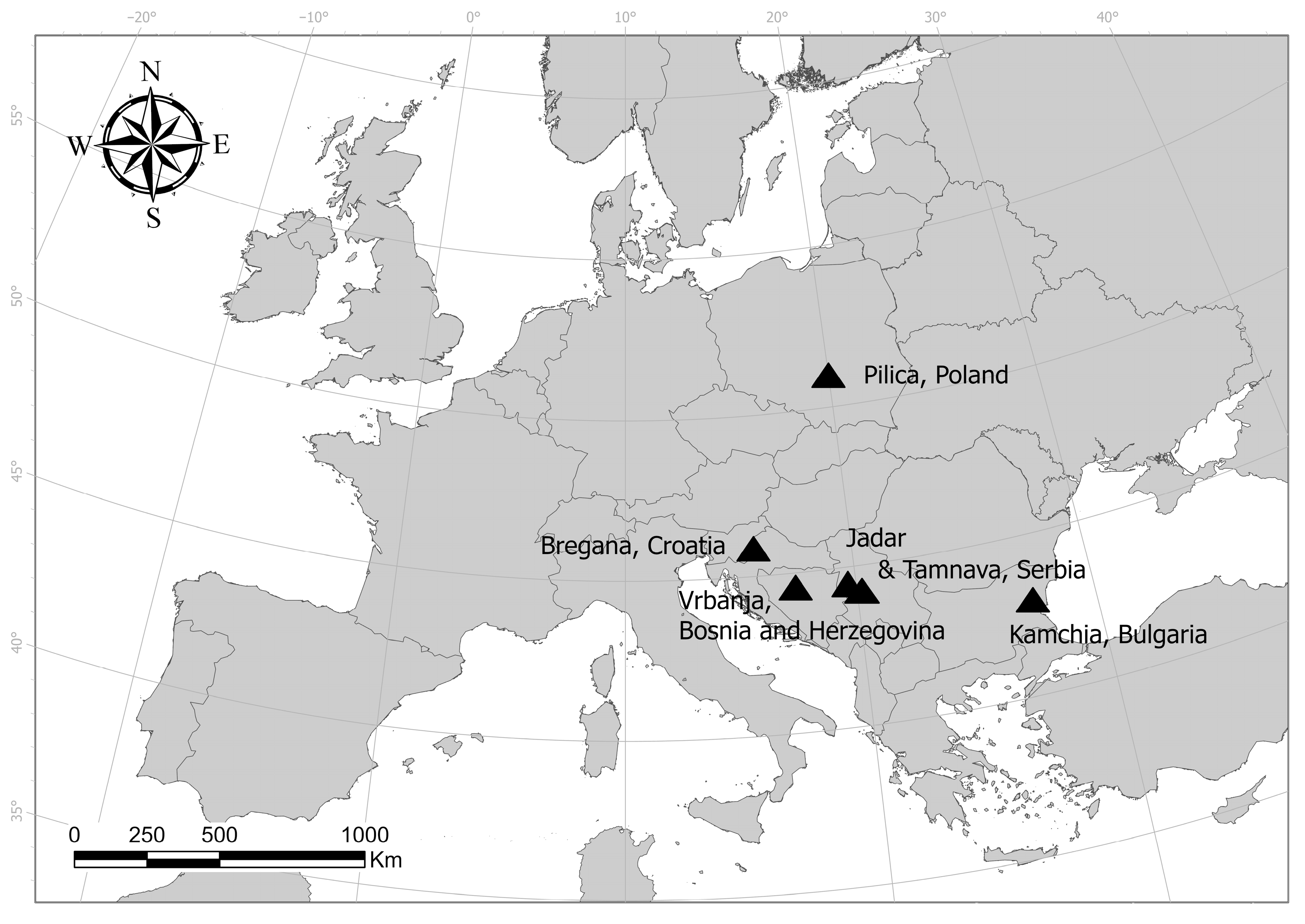
2.1. Case Studies
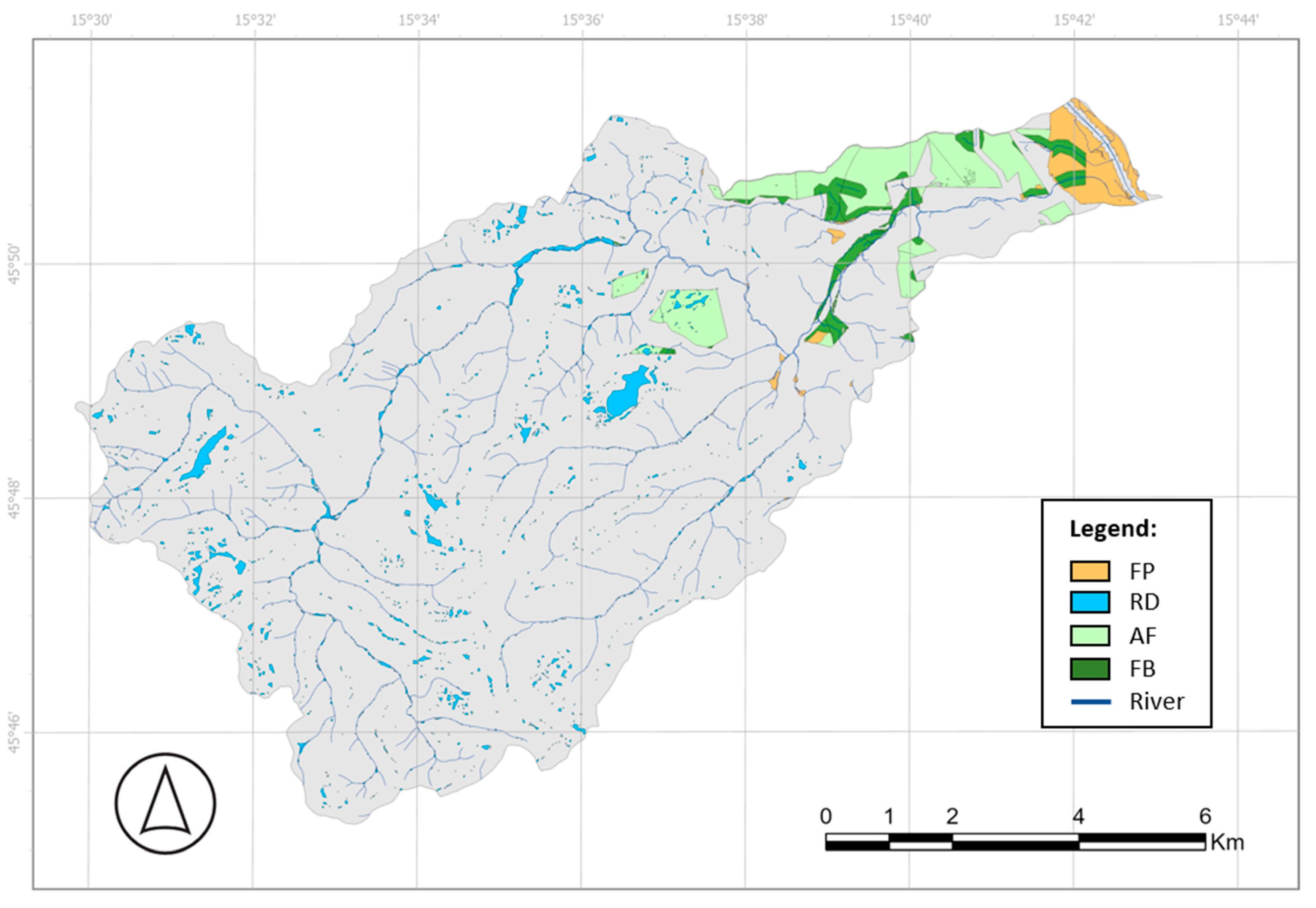
2.1.1. The Bregana River Basin, Croatia
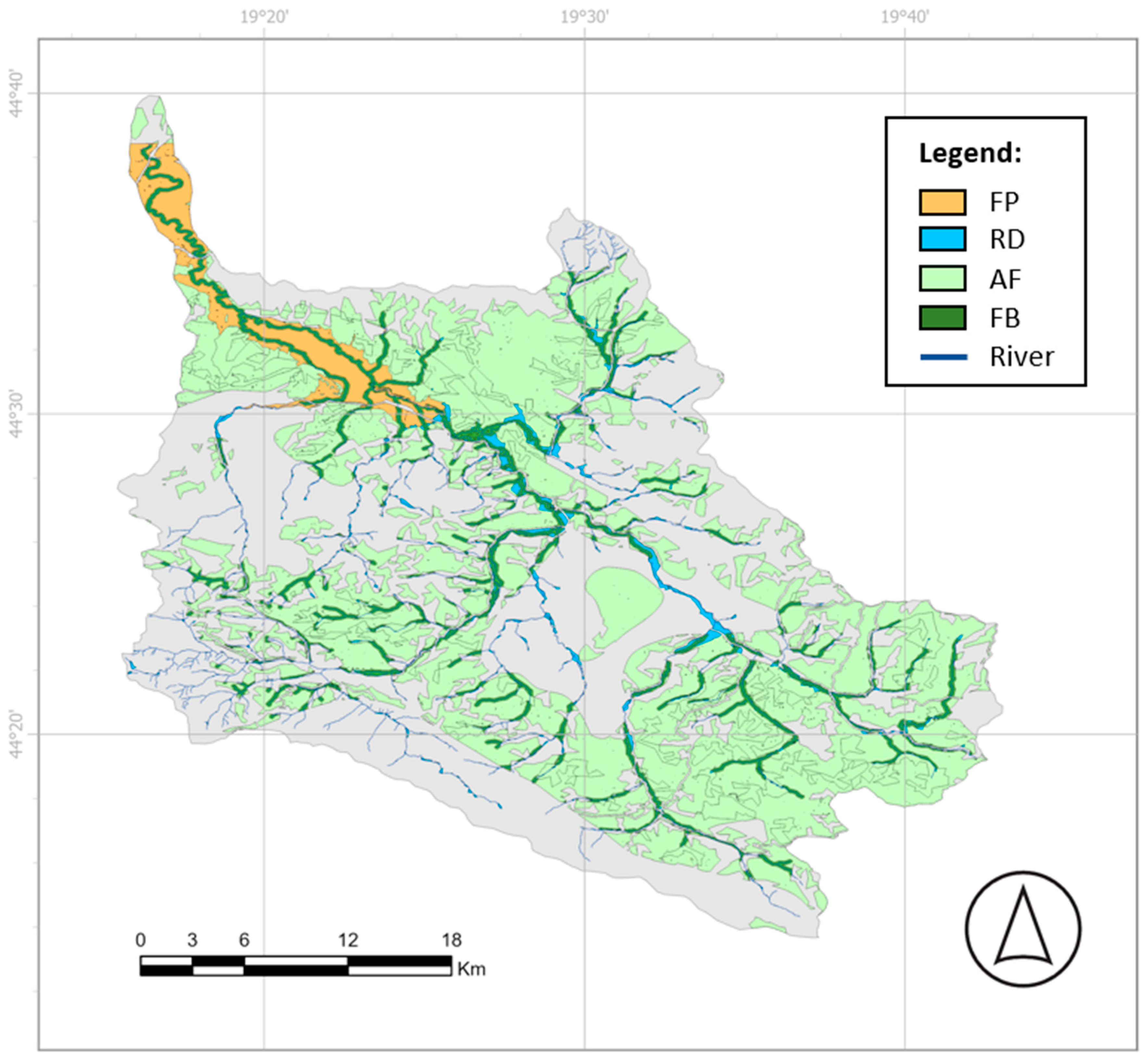
2.1.2. The Jadar River Basin, Serbia
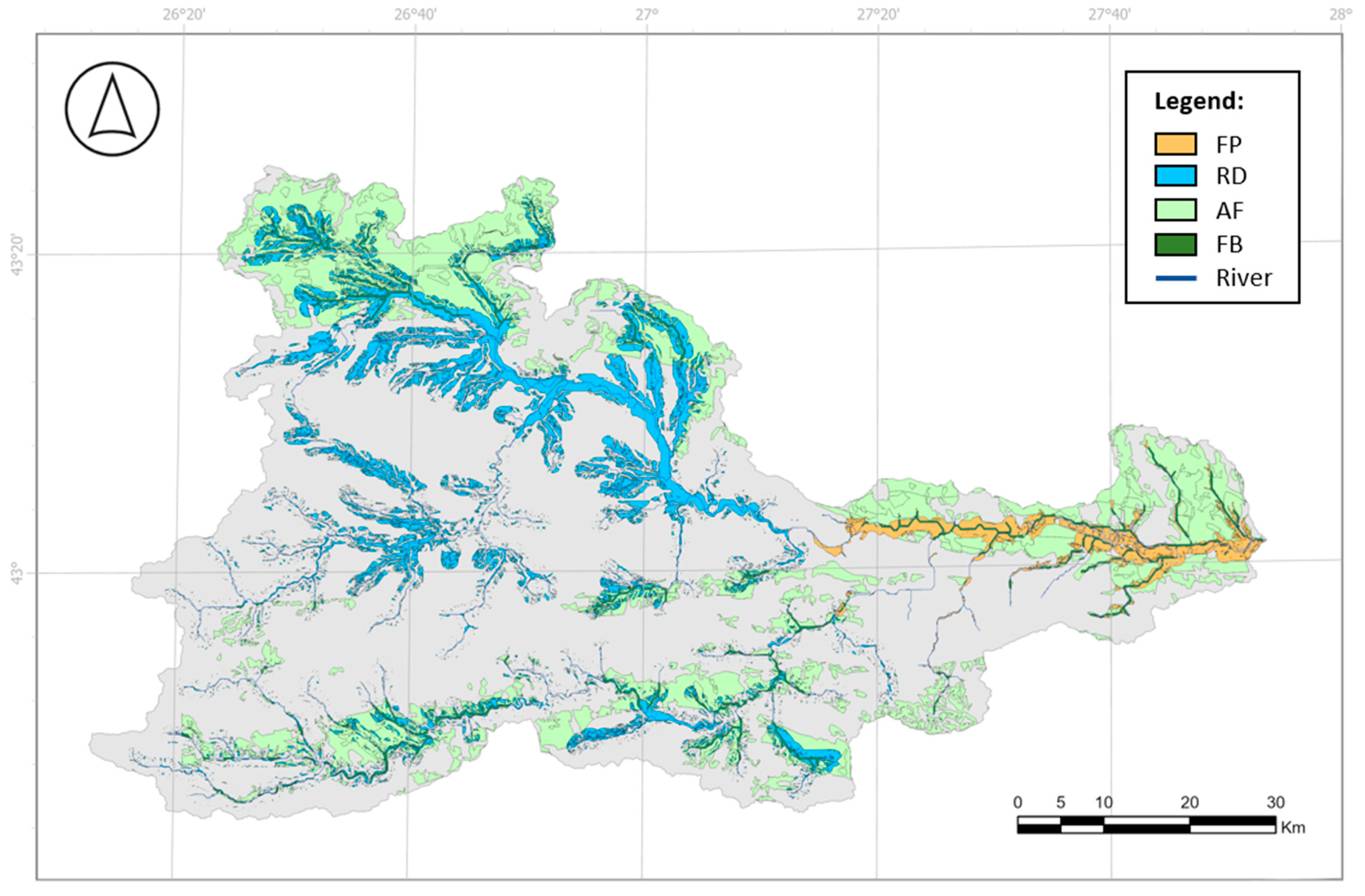
2.1.3. The Kamchia River Basin, Bulgaria
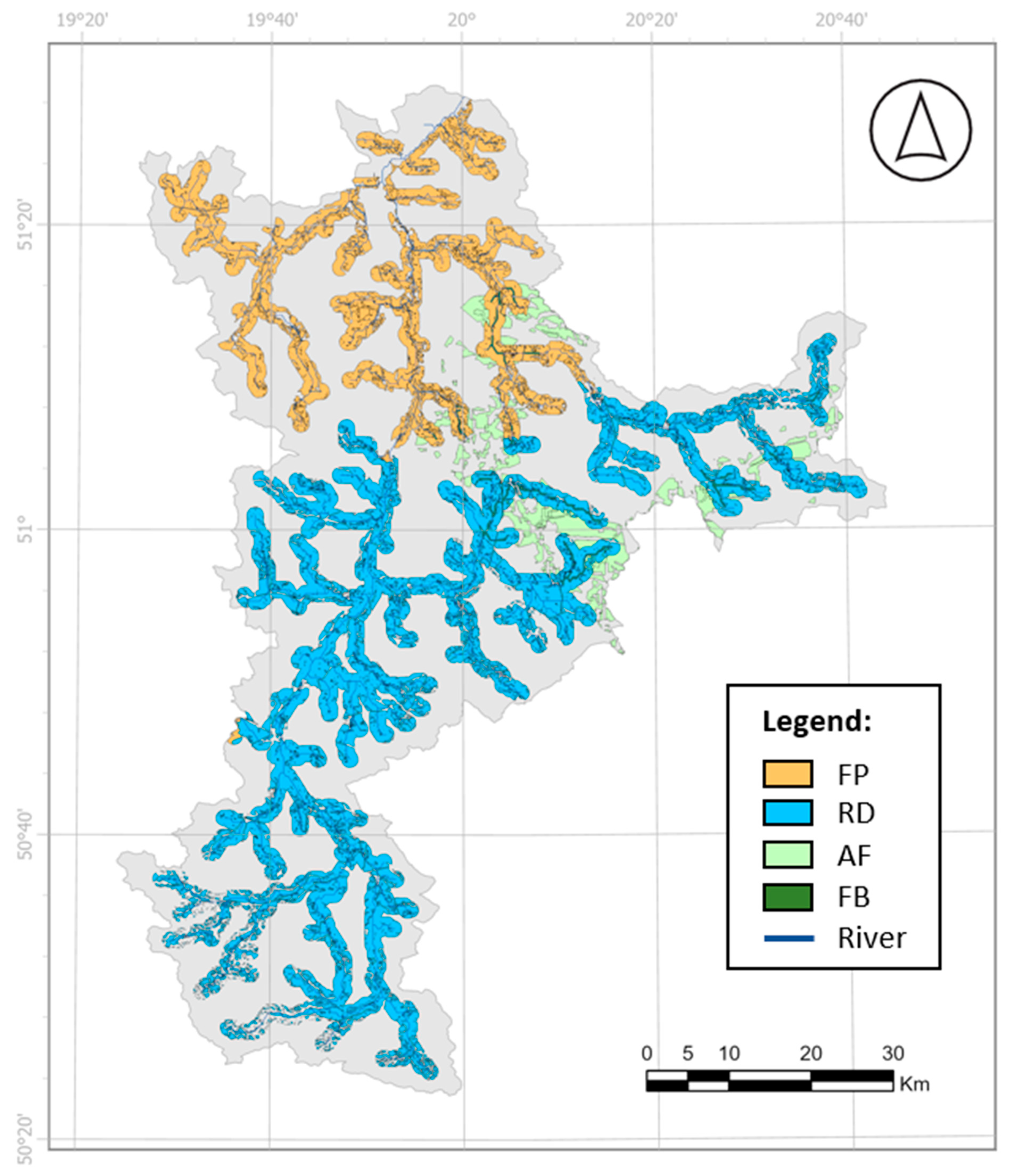
2.1.4. The Pilica River Basin, Poland
2.1.5. The Tamnava River Basin, Serbia
2.1.6. The Vrbanja River Basin, Bosnia and Herzegovina
2.2. Identification of Hazards and Needs
2.3. Selection of NBSs for Hydrometeorological Risk Reduction
2.4. Mapping Suitability of NBSs
2.4.1. Refining the Existing Model for Mapping Suitability
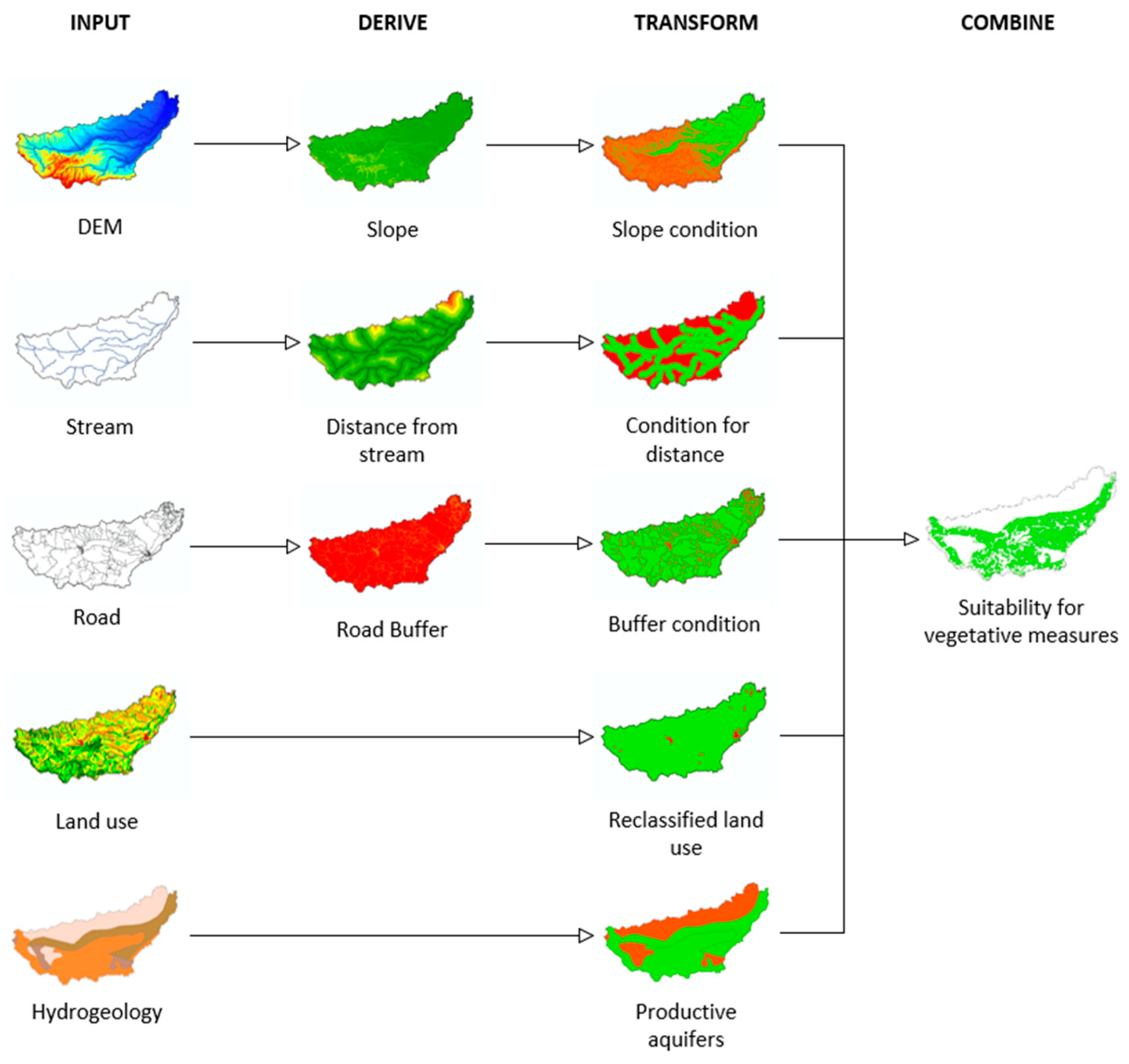
2.4.2. Criteria and Conditions for Mapping Suitability of Vegetative Measures
2.4.3. Setting up the Toolbox for Mapping Suitability
3. Results
4. Discussion
5. Conclusions
Supplementary Materials
Author Contributions
Funding
Data Availability Statement
Acknowledgments
Conflicts of Interest
Abbreviations
| CLC | Corine land cover |
| DEM | Digital elevation model |
| EbA | Ecosystem-based approach |
| ESA | European space agency |
| IHME | International 283 Hydrogeological Map of Europe |
| LULC | Land use land cover |
| NBS | Nature-based solution |
| MCA | Multi-criteria analysis |
| MCDM | Multi-criteria decision making |
Appendix A. Description of Nature-Based Solutions
Appendix A.1. Afforestation
Appendix A.2. Riparian Forest Buffer Strips
Appendix A.3. Detention Basins
Appendix A.4. Retention Ponds
Appendix B. Criteria and Conditions for Suitability of NBSs
| Criteria | Conditions | |||
|---|---|---|---|---|
| FP | RD | AF | FB | |
| Slope (%) | ≤5 | ≤5 | ≤60 | ≤60 |
| Distance from streams (m) | ≤1000 | ≤1000 | Not applicable | ≤100 |
| Distance from roads (m) | ≥50 | ≥50 | ≥50 | ≥50 |
| Code | Aquifer Name | Value |
|---|---|---|
| 1 | Highly productive fissured aquifers (including karstified rocks) | 1 |
| 2 | Highly productive porous aquifers | 1 |
| 3 | Inland water | 0 |
| 4 | Locally aquiferous rock, fissured or porous | 1 |
| 5 | Low and moderately productive fissured aquifers (including karstified rocks) | 0 |
| 6 | Low and moderately productive porous aquifers | 0 |
| 7 | Practically non aquiferous rocks, porous or fissured | 0 |
| 8 | Snowfield/ice field | 0 |
| Code | Landcover | Value |
|---|---|---|
| 10 | Tree cover | 1 |
| 20 | Shrubland | 1 |
| 30 | Grassland | 1 |
| 40 | Cropland | 1 |
| 50 | Built-up | 0 |
| 60 | Bare/sparse vegetation | 1 |
| 70 | Snow and ice | 0 |
| 80 | Permanent water bodies | 0 |
| 90 | Herbacious wetland | 0 |
| 95 | Mangroves | 0 |
| 100 | Moss and lichen | 1 |
| Code | Landcover | FP | RD | AF/FB |
|---|---|---|---|---|
| 111 | Continuous urban fabric | 0 | 0 | 0 |
| 112 | Discontinuous urban fabric | 0 | 0 | 0 |
| 121 | Industrial or commercial units | 0 | 0 | 0 |
| 122 | Road and rail networks and associated land | 0 | 0 | 0 |
| 123 | Port areas | 0 | 0 | 0 |
| 124 | Airports | 0 | 0 | 0 |
| 131 | Mineral extraction sites | 0 | 0 | 0 |
| 132 | Dump sites | 0 | 0 | 0 |
| 133 | Construction sites | 0 | 0 | 0 |
| 141 | Green urban areas | 1 | 1 | 1 |
| 142 | Sport and leisure facilities | 1 | 1 | 1 |
| 211 | Non-irrigated arable land | 1 | 1 | 1 |
| 212 | Permanently irrigated land | 1 | 1 | 1 |
| 213 | Rice fields | 1 | 1 | 1 |
| 221 | Vineyards | 1 | 1 | 1 |
| 222 | Fruit trees and berry plantations | 1 | 1 | 1 |
| 223 | Olive groves | 1 | 1 | 1 |
| 231 | Pastures | 1 | 1 | 1 |
| 241 | Annual crops associated with permanent crops | 1 | 1 | 1 |
| 242 | Complex cultivation patterns | 1 | 1 | 1 |
| 243 | Land principally occupied by agriculture, w. significant areas of natural vegetation | 1 | 1 | 1 |
| 244 | Agro-forestry areas | 1 | 1 | 1 |
| 311 | Broad-leaved forest | 1 | 1 | 0 |
| 312 | Coniferous forest | 1 | 1 | 0 |
| 313 | Mixed forest | 1 | 1 | 0 |
| 321 | Natural grasslands | 1 | 1 | 0 |
| 322 | Moors and heathland | 1 | 1 | 0 |
| 323 | Sclerophyllous vegetation | 1 | 1 | 0 |
| 324 | Transitional woodland-shrub | 1 | 1 | 0 |
| 331 | Beaches, dunes, sands | 1 | 1 | 0 |
| 332 | Bare rocks | 1 | 1 | 0 |
| 333 | Sparsely vegetated areas | 1 | 1 | 1 |
| 334 | Burnt areas | 1 | 1 | 1 |
| 335 | Glaciers and perpetual snow | 0 | 0 | 0 |
| 411 | Inland marshes | 1 | 1 | 0 |
| 412 | Peat bogs | 1 | 1 | 0 |
| 421 | Salt marshes | 1 | 1 | 0 |
| 422 | Salines | 1 | 1 | 0 |
| 423 | Intertidal flats | 1 | 1 | 0 |
| 511 | Water courses | 1 | 1 | 0 |
| 512 | Water bodies | 1 | 1 | 0 |
| 521 | Coastal lagoons | 0 | 0 | 0 |
| 522 | Estuaries | 0 | 0 | 0 |
| 523 | Sea and ocean | 0 | 0 | 0 |

Appendix C. Results
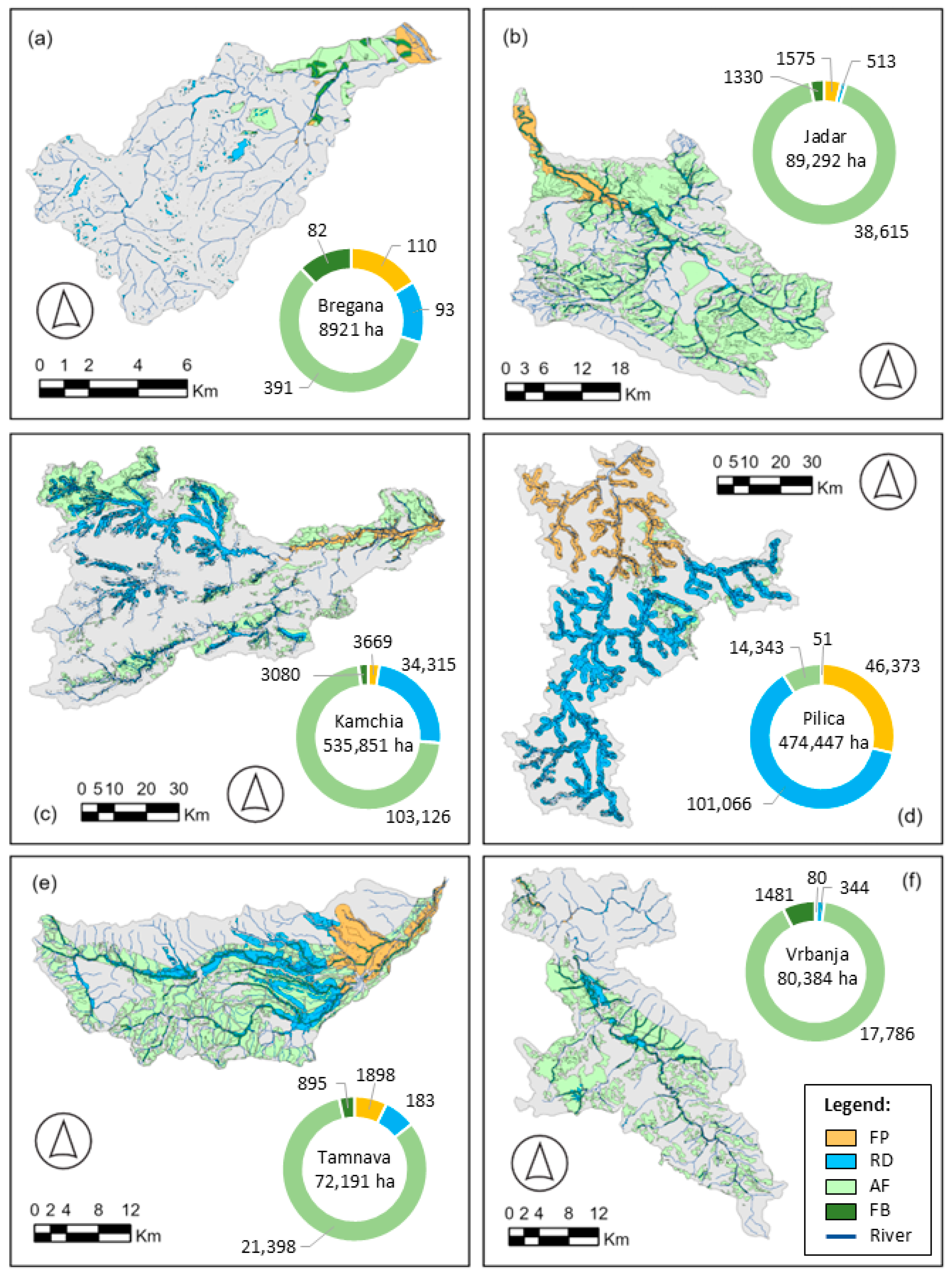
Appendix C.1. High-Resolution Maps of Results from Each Study Area

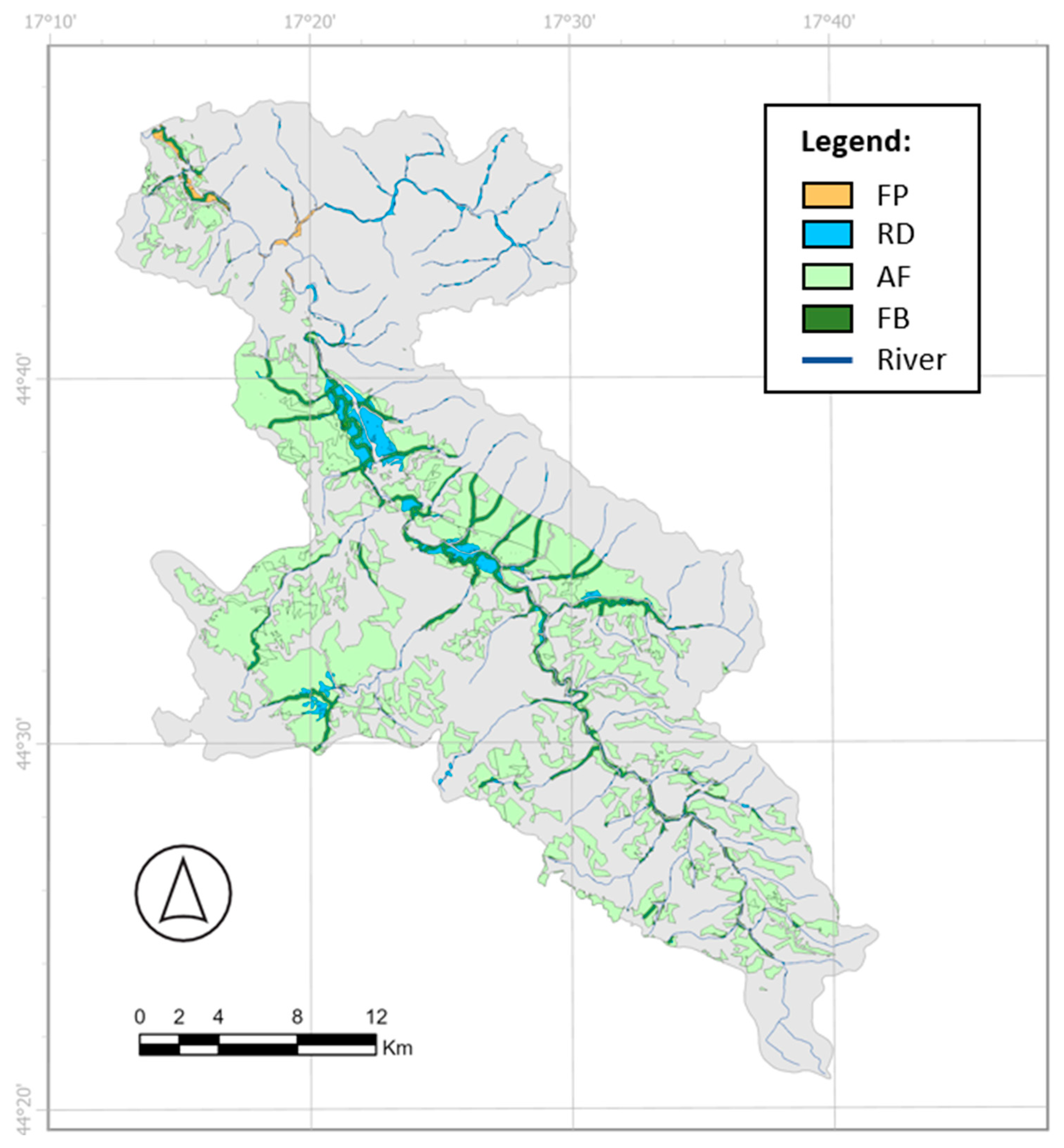
Appendix C.2. Data Tables with Additional Details
| Study Area | Suitable Area (ha) | ||||
|---|---|---|---|---|---|
| Basin | FP | RD | AF | FB | |
| Bregana | 8921 | 183 | 97 | 551 | 130 |
| Jadar | 89,292 | 4992 | 2174 | 45,023 | 3502 |
| Kamchia | 535,851 | 11,596 | 51,477 | 131,294 | 7671 |
| Pilica | 474,447 | 49,397 | 108,002 | 24,353 | 1615 |
| Tamnava | 72,191 | 5431 | 8266 | 32,258 | 2946 |
| Vrbanja | 80,384 | 255 | 1989 | 21,087 | 2344 |
| Study Area | Percentage of Basin Area Suitable (%) | |||
|---|---|---|---|---|
| FP | RD | AF | FB | |
| Bregana | 2.05 | 1.08 | 6.18 | 1.46 |
| Jadar | 5.59 | 2.43 | 50.42 | 3.92 |
| Kamchia | 2.16 | 9.61 | 24.50 | 1.43 |
| Pilica | 10.41 | 22.76 | 5.13 | 0.34 |
| Tamnava | 7.52 | 11.45 | 44.68 | 4.08 |
| Vrbanja | 0.32 | 2.47 | 26.23 | 2.92 |
| Study Area | Suitable Area (ha) | |||||
|---|---|---|---|---|---|---|
| Basin | FP | RD | AF | FB | Total | |
| Bregana | 8921 | 110 | 93 | 391 | 82 | 676 |
| Jadar | 89,292 | 1575 | 513 | 38,615 | 1330 | 42,033 |
| Kamchia | 535,851 | 3669 | 34,315 | 103,126 | 3080 | 144,190 |
| Pilica | 474,447 | 46,373 | 101,066 | 14,343 | 51 | 161,833 |
| Tamnava | 72,191 | 1898 | 1833 | 21,398 | 895 | 26,024 |
| Vrbanja | 80,384 | 80 | 344 | 17,786 | 1481 | 19,692 |
| Study Area | Percentage of Basin Area Suitable (%) | ||||
|---|---|---|---|---|---|
| FP | RD | AF | FB | Total | |
| Bregana | 1.23 | 1.04 | 4.39 | 0.92 | 7.58 |
| Jadar | 1.76 | 0.57 | 43.25 | 1.49 | 47.07 |
| Kamchia | 0.68 | 6.40 | 19.25 | 0.57 | 26.91 |
| Pilica | 9.77 | 21.30 | 3.02 | 0.01 | 34.11 |
| Tamnava | 2.63 | 2.54 | 29.64 | 1.24 | 36.05 |
| Vrbanja | 0.10 | 0.43 | 22.13 | 1.84 | 24.50 |
| Study Area | Suitable Area (ha) | |||
|---|---|---|---|---|
| AF & FP | AF & RD | FB & FP | FB & RD | |
| Bregana | 74 | 4 | 48 | 0 |
| Jadar | 3417 | 1661 | 968 | 1205 |
| Kamchia | 7926 | 17,162 | 1710 | 2881 |
| Pilica | 3024 | 6936 | 410 | 1154 |
| Tamnava | 3533 | 6433 | 491 | 1561 |
| Vrbanja | 174 | 1645 | 96 | 767 |
| Study Area | Percentage of Basin Area Suitable (%) | |||
|---|---|---|---|---|
| AF & FP | AF & RD | FB & FP | FB & RD | |
| Bregana | 74 | 4 | 48 | 0 |
| Jadar | 3417 | 1661 | 968 | 1205 |
| Kamchia | 7926 | 17,162 | 1710 | 2881 |
| Pilica | 3024 | 6936 | 410 | 1154 |
| Tamnava | 3533 | 6433 | 491 | 1561 |
| Vrbanja | 174 | 1645 | 96 | 767 |
References
- Kikstra, J.S.; Nicholls, Z.R.J.; Smith, C.J.; Lewis, J.; Lamboll, R.D.; Byers, E.; Sandstad, M.; Meinshausen, M.; Gidden, M.J.; Rogelj, J.; et al. The IPCC Sixth Assessment Report WGIII climate assessment of mitigation pathways: From emissions to global temperatures. Geosci. Model Dev. 2022, 15, 9075–9109. [Google Scholar] [CrossRef]
- Fujihira, K. Systematic method for identifying unsuitable land for development: Biodiversity, disaster risk, and topography. Acad. Environ. Sci. 2025, 2. [Google Scholar] [CrossRef]
- UNSD—Environment Statistics, United Nations. Available online: https://unstats.un.org/unsd/envstats/qindicators.cshtml (accessed on 15 May 2025).
- Seddon, N.; Smith, A.; Smith, P.; Key, I.; Chausson, A.; Girardin, C.; House, J.; Srivastava, S.; Turner, B. Getting the message right on nature-based solutions to climate change. Glob. Change Biol. 2021, 27, 1518–1546. [Google Scholar] [CrossRef]
- World Bank. A Catalogue of Nature-Based Solutions for Urban Resilience; World Bank Group: Washington, DC, USA, 2021; Available online: https://hdl.handle.net/10986/36507 (accessed on 17 January 2024).
- Ruangpan, L.; Vojinovic, Z.; Di Sabatino, S.; Leo, L.S.; Capobianco, V.; Oen, A.M.P.; McClain, M.E.; Lopez-Gunn, E. Nature-based solutions for hydro-meteorological risk reduction: A state-of-the-art review of the research area. Nat. Hazards Earth Syst. Sci. 2020, 20, 243–270. [Google Scholar] [CrossRef]
- Fokkens, B. The Dutch strategy for safety and river flood prevention. In Extreme Hydrological Events: New Concepts for Security; Vasiliev, O., van Gelder, P., Plate, E., Bolgov, M., Eds.; NATO Science Series; Springer: Dordrecht, The Netherlands, 2006; Volume 78, pp. 337–352. [Google Scholar] [CrossRef]
- Lockwood, T.; Freer, J.; Michaelides, K.; Brazier, R.E.; Coxon, G. Assessing the efficacy of offline water storage ponds for natural flood management. J. Hydrol. Process. 2022, 36, e14618. [Google Scholar] [CrossRef]
- Duraisekaran, E.; Mohanraj, T.; Samuel, J.S.K.; Rajagopalan, S.; Govindasamy, R. Investigation of multiple flood mitigation strategies for an urban catchment using semi-distributed hydrological modelling. Arab J. Geosci. 2021, 14, 1423. [Google Scholar] [CrossRef]
- Giraldo-Charria, D.L.; Escobedo, F.J.; Clerici, N.; Quesada, B. Urban forests mitigate extreme heat exposure in a vulnerable tropical city. Urban Clim. 2025, 59, 102311. [Google Scholar] [CrossRef]
- Faivre, N.; Fritz, M.; Freitas, T.; de Boissezon, B.; Vandewoestijne, S. Nature-Based Solutions in the EU: Innovating with nature to address social, economic and environmental challenges. Environ. Res. 2017, 159, 509–518. [Google Scholar] [CrossRef] [PubMed]
- Deane, A.; Norrey, J.; Coulthard, E.; McKendry, D.C.; Dean, A.P. Riverine large woody debris introduced for natural flood management leads to rapid improvement in aquatic macroinvertebrate diversity. Ecol. Eng. 2021, 163, 106197. [Google Scholar] [CrossRef]
- Lai, S.; Isola, F.; Leone, F.; Zoppi, C. Assessing the potential of green infrastructure to mitigate hydrogeological hazard. Evidence-based policy suggestions from a Sardinian study area. TEMA 2021, 2021, 109–133. [Google Scholar] [CrossRef]
- Chia, B.; Wang, Y.; Chen, Y. Flood resilience of urban river restoration projects: Case studies in Hong Kong. J. Manag. Eng. 2020, 36, 5020009. [Google Scholar] [CrossRef]
- Global Standard for Nature-Based Solutions: A User-Friendly Framework for the Verification, Design and Scaling Up of NbS, 1st ed.; IUCN: Gland, Switzerland, 2020. [CrossRef]
- Fontana, V.; Radtke, A.; Fedrigotti, V.B.; Tappeiner, U.; Tasser, E.; Zerbe, S.; Buchholz, T. Comparing land-use alternatives: Using the ecosystem services concept to define a multi-criteria decision analysis. Ecol. Econ. 2013, 93, 128–136. [Google Scholar] [CrossRef]
- Ruangpan, L.; Vojinovic, Z.; Plavšić, J.; Doong, D.-J.; Bahlmann, T.; Alves, A.; Tseng, L.-H.; Randelović, A.; Todorović, A.; Kocic, Z.; et al. Incorporating stakeholders’ preferences into a multi-criteria framework for planning large-scale Nature-Based Solutions. Ambio 2021, 50, 1514–1531. [Google Scholar] [CrossRef] [PubMed]
- Kuller, M.; Bach, P.M.; Roberts, S.; Browne, D.; Deletic, A. A planning-support tool for spatial suitability assessment of green urban stormwater infrastructure. Sci. Total Environ. 2019, 686, 856–868. [Google Scholar] [CrossRef]
- Voskamp, I.M.; Van de Ven, F.H. Planning support system for climate adaptation: Composing effective sets of blue-green measures to reduce urban vulnerability to extreme weather events. Build. Environ. 2015, 83, 159–167. [Google Scholar] [CrossRef]
- Meerow, S.; Newell, J.P. Spatial planning for multifunctional green infrastructure: Growing resilience in Detroit. Landsc. Urban Plan. 2017, 159, 62–75. [Google Scholar] [CrossRef]
- Mubeen, A.; Ruangpan, L.; Vojinovic, Z.; Sanchez Torres, A.; Plavšić, J. Planning and Suitability Assessment of Large-scale Nature-based Solutions for Flood-risk Reduction. Water Resour. Manag. 2021, 35, 3063–3081. [Google Scholar] [CrossRef]
- CORDIS. RECONECT Project. Brussels: Publications Office of the European Union. 2018. Available online: https://cordis.europa.eu/project/id/776866 (accessed on 15 May 2025).
- Plavšić, J.; Vladiković, D.; Despotović, J. Floods in the Sava River Basin in May 2014. In Proceedings of the Mediterranean Meeting on Monitoring, Modelling, Early Warning of Extreme Events Triggered by Heavy Rainfall, Cosenza, Italy, 26–28 June 2014; Available online: https://www.researchgate.net/publication/377463869 (accessed on 29 August 2025).
- Babić-Mladenović, M.; Kolarov, V. River Basin Studies as a Basis for Flood Risk Management Planning: The Kolubara River Basin Case Study. Water Res. Manag. 2016, 6, 3–9. [Google Scholar]
- European Commission. Overview of Natural and Man-Made Disaster Risks the European Union May Face: 2020 Edition; Directorate-General for European Civil Protection and Humanitarian Aid Operations (ECHO) Publications Office: Brussels, Belgium, 2021; Available online: https://data.europa.eu/doi/10.2795/1521 (accessed on 15 May 2025).
- Plavšić, J.; Ruangpan, L.; Vojinovic, Z.; Kuhlicke, C.; Han, S. D4.8: Prefeasibility Studies for Implementation of NBS in Collaborators. 2024. Available online: https://ec.europa.eu/research/participants/documents/downloadPublic?documentIds=080166e514113ec6&appId=PPGMS (accessed on 15 May 2025).
- Liera, C.; Esquivel, N.; Barquet, K.; Ruangpan, L.; Plavšić, J. D4.2: Baseline Assessment and Potential for NBS in Collaborators. 2022. Available online: https://ec.europa.eu/research/participants/documents/downloadPublic?documentIds=080166e5050f417c&appId=PPGMS (accessed on 22 April 2025).
- Vinet, F. From hazard reduction to integrated risk management: Toward adaptive flood prevention in Europe. Flood hazards, vulnerability and risk reduction. In Flood Hazards and Health; Taylor Francis Group: Abingdon, UK, 2013; Volume 118, pp. 113–122. [Google Scholar] [CrossRef]
- Serra-Llobet, A.; Jähnig, S.C.; Geist, J.; Kondolf, G.M.; Damm, C.; Scholz, M.; Lund, J.; Opperman, J.J.; Yarnell, S.M.; Pawley, A.; et al. Restoring rivers and floodplains for habitat and flood risk reduction: Experiences in multi-benefit floodplain management from California and Germany. Front. Environ. Sci. 2022, 9, 778568. [Google Scholar] [CrossRef]
- Corine Land Cover 2018 (Raster 100 m). European Union’s Copernicus Land Monitoring Service. 2019. Available online: https://doi.org/10.2909/960998c1-1870-4e82-8051-6485205ebbac (accessed on 21 June 2022).
- Zanaga, D.; Van De Kerchove, R.; Daems, D.; De Keersmaecker, W.; Brockmann, C.; Kirches, G.; Wevers, J.; Cartus, O.; Santoro, M.; Fritz, S.; et al. ESA WorldCover 10 m 2021 v200; The European Space Agency (ESA): Paris, France, 2022. [Google Scholar] [CrossRef]
- Kokutse, N.K.; Temgoua, A.G.T.; Kavazović, Z. Slope stability and vegetation: Conceptual and numerical investigation of mechanical effects. Ecol. Eng. 2016, 86, 146–153. [Google Scholar] [CrossRef]
- MacNeil, D.J.; Steele, D.P.; McMahon, W.; Carder, D.R. Vegetation for Slope Stability; TRL Report, 515; Transport Research Foundation: Berkshire, UK, 2001. [Google Scholar]
- Sotir, R.B.; Gray, D.H. Chapter 18: Soil Bioengineering for Upland Slope Protection and Erosion Reduction. In Engineering Field Handbook; Soil Conservation Service USDA: Washington, DC, USA, 1992. [Google Scholar]
- Mac Nally, R.; Molyneux, G.; Thomson, J.R.; Lake, P.S.; Read, J. Variation in widths of riparian-zone vegetation of higher-elevation streams and implications for conservation management. Plant Ecol. 2008, 198, 89–100. [Google Scholar] [CrossRef]
- Vidon, P.G.; Hill, A.R. Landscape controls on the hydrology of stream riparian zones. J. Hydrol. 2004, 292, 210–228. [Google Scholar] [CrossRef]
- BGR; UNESCO (Eds.) International Hydrogeological Map of Europe 1:1,500,000 (IHME1500). Digital Map Data v1.2. Hannover/Paris. 2019. Available online: https://services.bgr.de/grundwasser/ihme1500 (accessed on 21 June 2022).
- EU-DEM v 1.1 (Raster). European Union’s Copernicus Land Monitoring Service. 2016. Available online: https://sdi.eea.europa.eu/catalogue/srv/api/records/3473589f-0854-4601-919e-2e7dd172ff50 (accessed on 21 June 2022).
- Kpadé, C.P.; Tamini, L.D.; Pepin, S.; Khasa, D.P.; Abbas, Y.; Lamhamedi, M.S. Evaluating Multi-Criteria Decision-Making Methods for Sustainable Management of Forest Ecosystems: A Systematic Review. Forests 2024, 15, 1728. [Google Scholar] [CrossRef]
- Valente, R.A.; de Mello, K.; Metedieri, J.F.; Americo, C. A multicriteria evaluation approach to set forest restoration priorities based on water ecosystem services. J. Environ. Manag. 2021, 285, 112049. [Google Scholar] [CrossRef]
- Campos, V.S.; Lopes, T.R.; de Oliveira Macedo, M.; Santos, F.S.; Silva, J.A.; Francisco, J.P.; Leite, F. Multicriteria geospatial analysis for prioritizing soil erosion risk areas in a reservoir-contributing watershed. J. S. Am. Earth Sci. 2025, 165, 105714. [Google Scholar] [CrossRef]
- Bozali, N. Assessment of the soil protection function of forest ecosystems using GIS-based Multi-Criteria Decision Analysis: A case study in Adıyaman, Turkey. Glob. Ecol. Conserv. 2020, 24, e01271. [Google Scholar] [CrossRef]
- Assumma, V.; Quagliolo, C.; Comino, E.; Mondini, G. Definition of an Integrated Theoretical Framework to Assess the NBS Suitability in Flood Risk Areas. In Proceedings of the Computational Science and Its Applications—ICCSA 2022 Workshops, Malaga, Spain, 4–7 July 2022; Gervasi, O., Murgante, B., Misra, S., Rocha, A.M.A.C., Garau, C., Eds.; ICCSA 2022, Lecture Notes in Computer Science. Springer: Cham, Switzerland, 2022; p. 13380. [Google Scholar] [CrossRef]
- RECONECT. D5.5: Report Describing the Potential for Implementation of Large-scale NbS in Europe. 2025. Available online: https://ec.europa.eu/research/participants/documents/downloadPublic?documentIds=080166e5f66fb570&appId=PPGMS (accessed on 13 June 2025).
- Gadi, V.K.; Tang, Y.R.; Das, A.; Monga, C.; Garg, A.; Berretta, C.; Sahoo, L. Spatial and temporal variation of hydraulic conductivity and vegetation growth in green infrastructures using infiltrometer and visual technique. Catena 2017, 155, 20–29. [Google Scholar] [CrossRef]
- Liu, Y.; Chai, Y.; Yue, Y.; Huang, Y.; Yang, Y.; Zhu, B.; Lou, D.; Li, Y.; Shi, D.; Ullah, W. Effects of global greening phenomenon on water sustainability. Catena 2022, 208, 105732. [Google Scholar] [CrossRef]
- Sungmin, O.; Bastos, A.; Reichstein, M.; Li, W.; Denissen, J.; Graefen, H.; and Orth, R. The role of climate and vegetation in regulating drought–heat extremes. J. Clim. 2022, 35, 5677–5685. [Google Scholar] [CrossRef]
- Paletto, A.; Pieratti, E.; De Meo, I.; Agnelli, A.E.; Cantiani, P.; Chiavetta, U.; Mazza, G.; Lagomarsino, A. A multi-criteria analysis of forest restoration strategies to improve the ecosystem services supply: An application in Central Italy. Ann. For. Sci. 2021, 78, 7. [Google Scholar] [CrossRef]
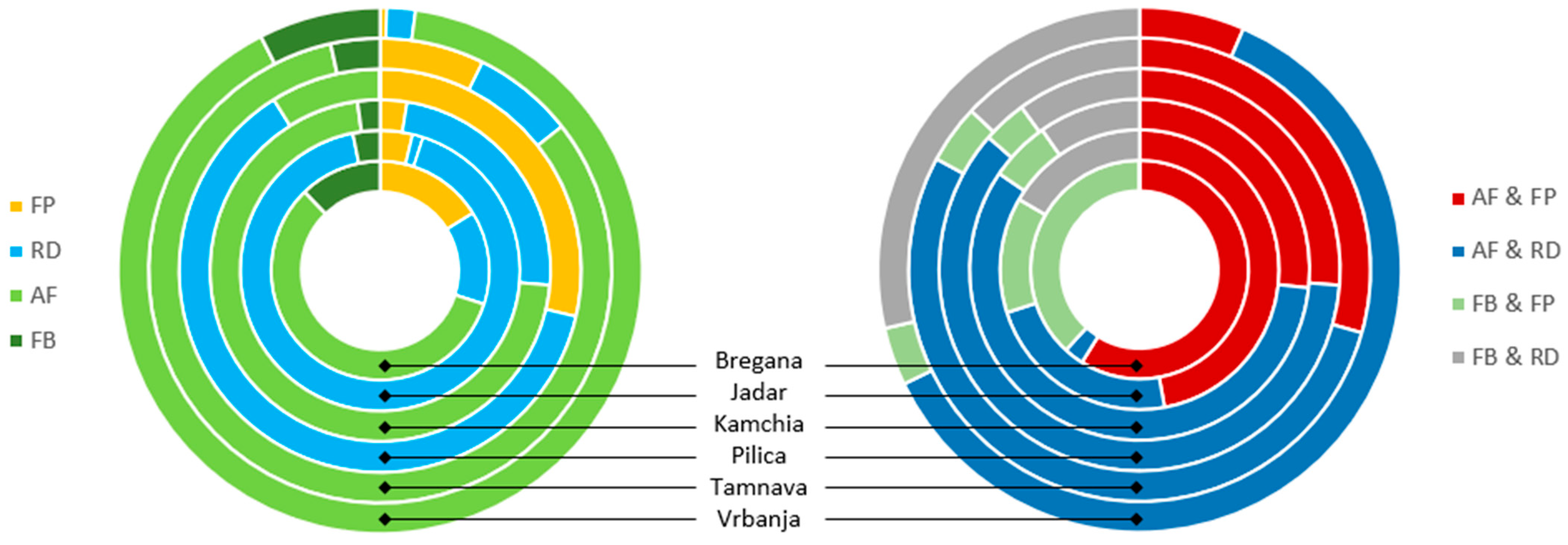
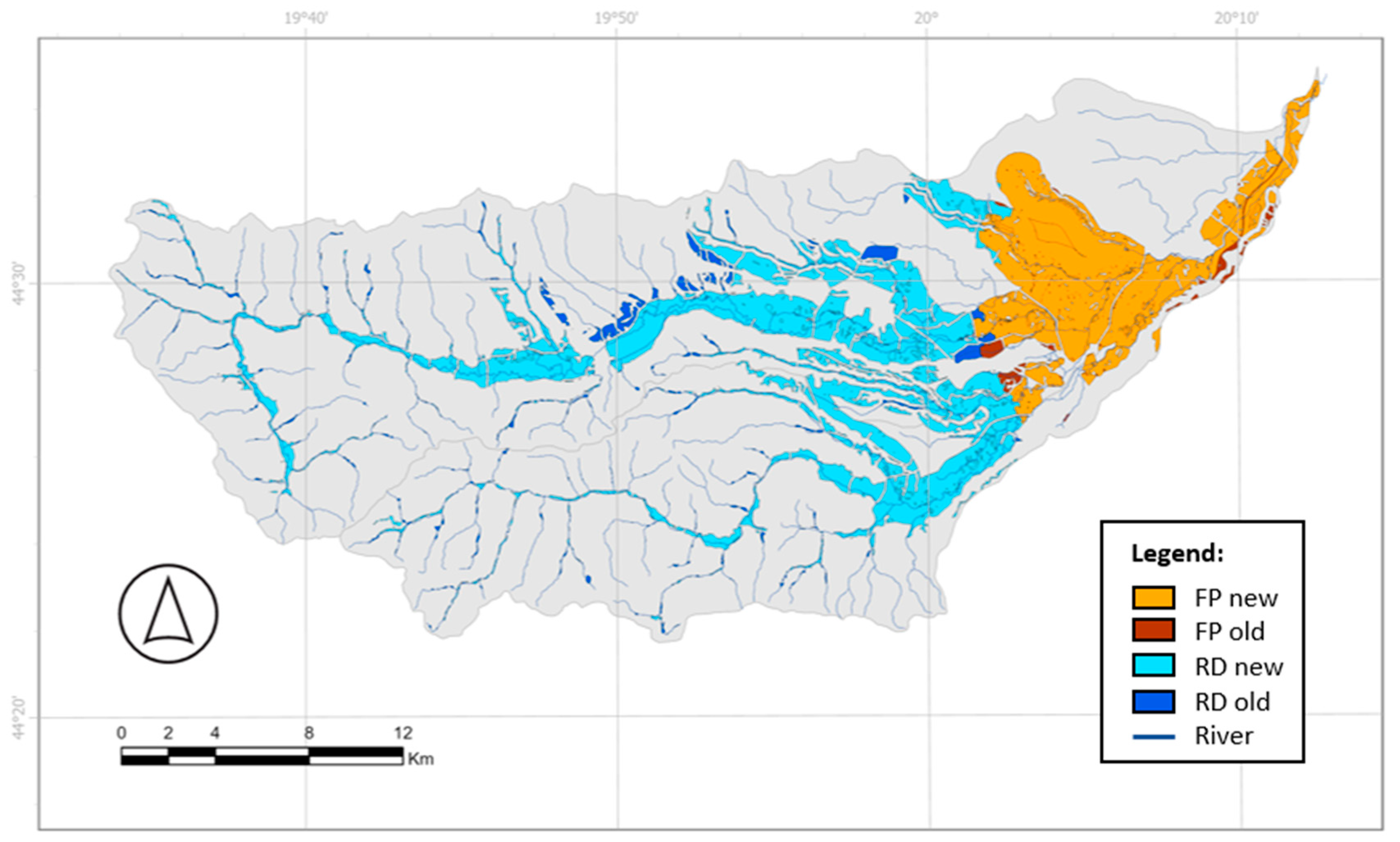
| Input Data | Type and Resolution | Source |
|---|---|---|
| DEM (EU-DEM) | Raster (30 m) | https://ec.europa.eu/eurostat/web/gisco (accessed on 21 June 2022) |
| River Network | Vector (500 m) | https://www.hydrosheds.org (accessed on 20 June 2022) |
| Road Network | Vector (500 m) | https://mapcruzin.com (accessed on 20 June 2022) |
| LULC (CLC 2018) | Raster (100 m) | https://land.copernicus.eu (accessed on 21 June 2022) |
| LULC (WorldCover 2021) | Raster (10 m) | https://esa-worldcover.org (accessed on 21 June 2022) |
| Hydrogeology (IHME 1500) | Vector (1500 m) | https://www.bgr.bund.de (accessed on 21 June 2022) |
| Study Area | Area (ha) | Basin Area Suitable for NBS (%) | |||||
|---|---|---|---|---|---|---|---|
| Basin | FP | RD | AF | FB | Total | ||
| Bregana | 8921 | 110 | 93 | 391 | 82 | 676 | 7.58 |
| Jadar | 89,292 | 1575 | 513 | 38,615 | 1330 | 42,033 | 47.07 |
| Kamchia | 535,851 | 3669 | 34,315 | 103,126 | 3080 | 144,190 | 26.91 |
| Pilica | 474,447 | 46,373 | 101,066 | 14,343 | 51 | 161,833 | 34.11 |
| Tamnava | 72,191 | 1898 | 1833 | 21,398 | 895 | 26,024 | 36.05 |
| Vrbanja | 80,384 | 80 | 344 | 17,786 | 1481 | 19,692 | 24.50 |
| Study Area | Suitable Area (ha) | ||||
|---|---|---|---|---|---|
| Basin | FP | RD | AF | FB | |
| Bregana | 8921 | 183 | 97 | 551 | 130 |
| Jadar | 89,292 | 4992 | 2174 | 45,023 | 3502 |
| Kamchia | 535,851 | 11,596 | 51,477 | 131,294 | 7671 |
| Pilica | 474,447 | 49,397 | 108,002 | 24,353 | 1615 |
| Tamnava | 72,191 | 5431 | 8266 | 32,258 | 2946 |
| Vrbanja | 80,384 | 255 | 1989 | 21,087 | 2344 |
| Study Area | Length (km) | Stream Length Suitable for FB (%) | |
|---|---|---|---|
| Streams | Suitable for FB | ||
| Bregana | 188 | 7.91 | 4.21 |
| Jadar | 643 | 254.83 | 39.63 |
| Kamchia | 1230 | 367.24 | 29.87 |
| Pilica | 1065 | 78.38 | 7.36 |
| Tamnava | 720 | 159.53 | 22.15 |
| Vrbanja | 466 | 114.18 | 24.50 |
| Study Area | Area (ha) | ||
|---|---|---|---|
| Conveyance (FP) | Storage (RD) | Source Control (AF + FB) | |
| Bregana | 110 | 93 | 474 |
| Jadar | 1575 | 513 | 39,945 |
| Kamchia | 3669 | 34,315 | 106,206 |
| Pilica | 46,373 | 101,066 | 14,393 |
| Tamnava | 1898 | 1833 | 22,293 |
| Vrbanja | 80 | 344 | 19,267 |
Disclaimer/Publisher’s Note: The statements, opinions and data contained in all publications are solely those of the individual author(s) and contributor(s) and not of MDPI and/or the editor(s). MDPI and/or the editor(s) disclaim responsibility for any injury to people or property resulting from any ideas, methods, instructions or products referred to in the content. |
© 2025 by the authors. Licensee MDPI, Basel, Switzerland. This article is an open access article distributed under the terms and conditions of the Creative Commons Attribution (CC BY) license (https://creativecommons.org/licenses/by/4.0/).
Share and Cite
Mubeen, A.; Devanand, V.B.; Ruangpan, L.; Vojinovic, Z.; Sanchez Torres, A.; Plavšić, J.; Manojlovic, N.; Paliaga, G.; Abdullah, A.F.; Leitão, J.P.; et al. A Geospatial Assessment Toolbox for Spatial Allocation of Large-Scale Nature-Based Solutions for Hydrometeorological Risk Reduction. Hydrology 2025, 12, 272. https://doi.org/10.3390/hydrology12100272
Mubeen A, Devanand VB, Ruangpan L, Vojinovic Z, Sanchez Torres A, Plavšić J, Manojlovic N, Paliaga G, Abdullah AF, Leitão JP, et al. A Geospatial Assessment Toolbox for Spatial Allocation of Large-Scale Nature-Based Solutions for Hydrometeorological Risk Reduction. Hydrology. 2025; 12(10):272. https://doi.org/10.3390/hydrology12100272
Chicago/Turabian StyleMubeen, Adam, Vishal Balaji Devanand, Laddaporn Ruangpan, Zoran Vojinovic, Arlex Sanchez Torres, Jasna Plavšić, Natasa Manojlovic, Guido Paliaga, Ahmad Fikri Abdullah, João P. Leitão, and et al. 2025. "A Geospatial Assessment Toolbox for Spatial Allocation of Large-Scale Nature-Based Solutions for Hydrometeorological Risk Reduction" Hydrology 12, no. 10: 272. https://doi.org/10.3390/hydrology12100272
APA StyleMubeen, A., Devanand, V. B., Ruangpan, L., Vojinovic, Z., Sanchez Torres, A., Plavšić, J., Manojlovic, N., Paliaga, G., Abdullah, A. F., Leitão, J. P., Wojcieszak, A., Rutkowska-Filipczak, M., Izydorczyk, K., Sudar, T., Deduš, B., Kvesić, D., Ikonomov, L., & Penchev, V. (2025). A Geospatial Assessment Toolbox for Spatial Allocation of Large-Scale Nature-Based Solutions for Hydrometeorological Risk Reduction. Hydrology, 12(10), 272. https://doi.org/10.3390/hydrology12100272


