Article

Evaluation of Potential Changes in Extreme Discharges over Some Watersheds in Côte d’Ivoire

by
N’da Jocelyne Maryse Christine Amichiatchi
1,2,*,
Gneneyougo Emile Soro
3,
Jean Hounkpè
1,2,
Tie Albert Goula Bi
3 and
Agnidé Emmanuel Lawin
1,2
1
Graduate Research Programme on Climate Change and Water Resource, University of Abomey-Calavi, Cotonou BP 526, Benin
2
Laboratory of Applied Hydrology, National Water Institute, University of Abomey-Calavi, Cotonou BP 4521, Benin
3
Research Unit Environmental Science and Management, Nangui Abrogoua University, Abidjan BP 801, Côte d’Ivoire
*
Author to whom correspondence should be addressed.
Hydrology 2023, 10(1), 6; https://doi.org/10.3390/hydrology10010006
Submission received: 6 December 2022 / Revised: 21 December 2022 / Accepted: 23 December 2022 / Published: 28 December 2022

Abstract

:
Climate change has had strong impacts on water resources over the past decades in Côte d’Ivoire, but these impacts on hydrological extremes remain largely unknown in most watersheds. Thus, this work aimed to evaluate the trends and breakpoints in extreme discharge characteristics of five watersheds in Côte d’Ivoire over the period 1970 to 2017. Seven indexes were selected, namely the 5-day maximum flow (QX5-days), peak discharge (Qmaxan), maximum monthly discharge (VCX30), annual minimum discharge (Qminan), average monthly discharge (QMNA), discharge day rate (VCN7), and characteristic of low discharge (WFD). The analysis was done using the modified Mann–Kendall (MMK) test and the standard normal homogeneity test at a 5% significance level for heterogeneous and homogeneous periods of data. The results for the heterogeneous and homogeneous periods were similar, with a predominance of non-significant trends for high discharge, except for the VCX30 index, which showed a significant upward trend at Kahin station. A decreasing trend for QX5-days was found at Loboville station. The variables Qminan, QMNA, VCN7, and WDF show significant upward trends of 33%, 16%, 50%, and 33% for the heterogeneous stations, respectively. A significant breakpoint in almost all variables was obtained, with a strong decrease after 2008. Some differences between the results from the heterogeneous and homogeneous periods of data were found and discussed. This study can help in understanding the behaviour of past hydrological extremes in the study area and in planning for further studies in the future.

1. Introduction

Extreme weather events have become more recurrent in recent decades, affecting socioeconomic activities and life worldwide. Water resources are currently under the influence of many natural and anthropogenic factors; river flows are increasing in some places, causing major floods, and decreasing in other places, causing alarming socioeconomic damage. Africa, like other continents around the world, has been confronted for decades with the occurrence of extreme events that affect the socioeconomic conditions every year. Many scientists across the continent have conducted intensive studies on these extremes (drought and flood) to enable policymakers to plan adaptation measures for the benefit of the community. In North Africa, specifically in Morocco, for example, Meliho et al. [1] showed that the drought years experienced during the analysed period affected the water releases into the Takerkoust Dam, with consequences for irrigation water supply and the local economy. In the Chad region (Central Africa), Abdoulaye et al. [2] showed an increase in consequent dry days linked to persistent drought. Nyirenda et al. [3] found intense and persistent rainfall events in Lusaka and Livingstone (Zambia). The Limpopo catchment in South Africa experiences frequent dry and wet conditions resulting in droughts and flash floods, respectively [4]. Like these parts of Africa, many countries in West Africa experience these extremes every year, resulting in loss of life and property [5]. Climate change and its consequences have been highlighted In the scientific literature, with several studies having been conducted. For example, the impacts of climate change on the characteristics of extreme rainfall events in four African coastal cities were analysed [6,7]. Similarly, in Mali, flooding [8] has become a somewhat frequent phenomenon. Additionally, the number of consecutive dry days has increased considerably and the number of consecutive wet days has decreased, making Niger vulnerable to extreme events [9]. In Ghana, Larbi et al. [10] showed a high frequency and intensity of extreme rainfall indices in the southern part of the catchment, while temperature extremes were evenly distributed over the catchment. Thus, like all West African countries, Côte d’Ivoire has also been affected for several decades by extreme events (floods and droughts) due to the effects of climate change [11,12]. These effects are manifested by irregularities and more or less random crises, sometimes involving successive phases of surplus, while in other cases involving water deficits, thereby altering the availability of water resources and the socioeconomic cost of living. For example, in 2018, many cities in Côte d’Ivoire (Bouaké, Korhogo, Tiébissou, Niakaramandougou, Odienné, etc.) experienced prolonged episodes of drought, causing difficulties in the country in the supply of drinking water to the populations of these different cities [13]. In contrast to these cities, Abidjan, Zuenoula, Bouaflé, Tiassalé, Touleupleu, N’douci, Sassandra, Fresco, Gagnoa, Korhogo, Ferké, Aboisso, and Agboville experienced devastating floods with deplorable damage [14] in the same year. In order to better anticipate the consequences of hydrological extremes, it is essential to analyse the changes already observed in the components of the water cycle through the analysis of river flows, which is undoubtedly an indispensable variable in the study of extremes. In Côte d’Ivoire, most studies have focused on climatic variability and water resources, meaning the assessment of flow trends has become essential. Analysing the trends and break points of extreme flows in the catchments would provide a better understanding of the evolution of extreme phenomena and their consequences (Lobo, N’zo, Agneby, Kouto, and Baya). These catchments have been the subject of several studies, such as the Lobo catchment, which has a high demand for water resources that is far from being met [15]. It is also experiencing strong degradation of the vegetation cover and an increasing rate of water erosion [16]. On the Bagoue River, a deficit of 87.7% was recorded during the last episode of deficient recharge, showing a decrease in groundwater [17]. Given the importance of extreme events and population dynamics in Côte d’Ivoire, this study is necessary. This work, therefore, aims to assess the trends and breakpoints of extreme flows in selected catchments of Côte d’Ivoire over the period 1970 to 2017, in order to help decision-makers regarding the welfare of the population and the local economy.

2. Materials and Methods

2.1. Study Area

Côte d’Ivoire is located in West Africa, in the intertropical zone, between the equator and the Tropic of Cancer, precisely between latitudes 4°30′ and 10°30′ north and longitudes 8°30′ and 2°30′ west. Rainfall is more abundant on the coast, where it is between 1500 and 2500 mm per year, while in the inland areas, it is generally less intense and ranges from 1200 to 1500 mm per year, even though it reaches 2000 mm in the small western mountainous area [18]. Additionally, the country generally experiences a rainy season from June to October, and the average annual temperatures range from 24–28 °C [18]. Côte d’Ivoire is relatively flat, with no high mountains except for the Man region in the west, with some peaks reaching over 1000 m. In the south of the country, some undulating plains rise slightly from south to north through the center of the country. The land use and land cover in Côte d’Ivoire changed dramatically over the 38 years between 1975 and 2013. Most striking has been the expansion of agriculture, with a net increase of 84% (31,600 sq km) [19]. In this study, five watershed areas were selected according to the four climatic zones [20] and the existence or not of hydraulic structures in these selected watershed areas. The five selected watersheds (N’zo, Nibéhibé, Agneby, Bagoue, and Baya) and the climatic zones are shown in Figure 1, and their characteristics are also presented in Table 1.

2.2. Data Used

The historical data used in this study are daily discharge data from 6 hydrometric stations found within the selected watershed. The choice of these stations was made according to the number of years of observations with good spatial representativeness, statistical information, and geographical position. The data were obtained from the General Directorate of Human Hydraulic Infrastructures (DGIHH) of Côte d’Ivoire. These daily discharges cover the periods of 1970–2017 for the Agneby watershed, 1980–2017 for the N’zo watershed, 1980–2018 for the Bagoue watershed, 1980–2004 for the Baya watershed and Lobo watershed with two different stations, 1988–2015 for Loboville, and 1980–2017 for Nibehibe.

2.3. Interannual Variation of Discharge

The hydrometric data are under the influence of climatic variability, and taking stock of the time series allows a good observation of the interannual fluctuations, which is obtained by eliminating the seasonal variations. Thus, we first proceeded to filter the data to eliminate seasonal variations using the non-recursive low-pass Hanning filter of order 2 (weighted moving averages) to better visualize the periods of deficit and surplus on an interannual scale. This exercise was performed using the equations recommended by Tyson et al. [21] and used by Blé et al. [22] and Yao [23] with good results. According to this method, each term in the series is calculated by the following equation:
X t = 0.06 x t 2 + 0.25 x t 1 + 0.38 x t + 0.25 x t + 1 + 0.06 x t + 2
where x t 2 and x t 1 are the totals of the observed discharges of two terms immediately preceding the term x t ;   x t + 2 and x t + 1 are the totals of the observed discharges of two terms immediately following the term x t .
The weighted discharge totals of the first two (X1 and X2) and the last two (Xn−1 and Xn−2) terms of the series are calculated using Equations (3)–(6) (with n being the size from the series):
X 1 = 0.54 x 1 + 0.46 x 2
X 2 = 0.25 x 1 + 0.50 x 2 + 0.25 x 3
X n 1 = 0.25 x n 2 + 0.50 x n 1 + 0.25 x n
X n = 0.54 x n + 0.46 x n 1
To better visualize the periods of deficit and surplus, the flow is centered and reduced using the following equation:
Y t = X t m σ
where Y t is the average discharge, X t is total annual weighted flows, m is the mean of the series of weighted means, and σ is the standard deviation of the series of weighted moving averages.

2.4. Description and Extraction of Extreme Discharge Indices

The extraction of discharge indices is an essential process for the study of extreme discharges in hydrology. This process requires good availability of the data to be used, so the missing data in our case study were first replaced by the result of rainfall-runoff modelling with the GR4J after the calibration and validation process. Seven (7) indices were selected to characterise the extreme flows, namely the 5-day maximum flow (QX5-days), peak flow (Qmaxan), maximum monthly flow (VCX30), minimum annual flow (Qminan), mean monthly flow (QMNA), daily flow (VCN7), and low-water feature (WFD). These indices have been widely used in several studies with good results and are representative of flood and drought characteristics [11,13,24,25,26,27]. R software was used to extract all variables. Qmaxan and Qminan were extracted by choosing the maximum (or minimum) annual discharge, and VCN7 was extracted annually on the basis of moving averages, calculated from the average daily discharges over seven (7) consecutive days [11,26,27,28,29]. The QMNA was extracted by selecting the lowest mean monthly flow of the year and the low water flows calculated from the daily moving averages [13,28]. The WFD was extracted by taking, for a given year, the minimum monthly flows less than or equal to the 0.03 quantile [30]. The VCX30 was extracted by taking the maximum average flow over 30 consecutive days and it was stated that for each year the data can be classified as below normal when below the first quartile, above normal when above the third quartile, and normal when in between. The QX5-days was extracted annually on the basis of moving averages, calculated from the average daily maximum discharges over five (5) consecutive days. All indices are summarised in Table 2 below.

2.5. Detection of Trends and Breakpoints in the Discharge Series

2.5.1. Modified Mann–Kendall Test

The trends in the hydrometric data series were evaluated using the modified Mann–Kendall test [31], which is a non-parametric test used in several studies. The choice of this test was justified by the fact that it takes into account the effect of autocorrelation in the data. Indeed, the presence of autocorrelation in the data affects the power of the classical Mann–Kendall statistical test by introducing outliers, and the effect of positive autocorrelation increases the risk of rejecting the type 1 error (overestimated trends), while the effect of negative autocorrelation modifies the risk of rejecting the type 1 error (underestimated trends). Therefore, an additional contribution to the Mann–Kendall (MK) test was made to take into account this autocorrelation phenomenon. The principle is based on a modification of the (S) statistic in the MK test. Based on this principle, a modified version of the original MK test was proposed [31], in which the variance of the test statistic is modified to account for autocorrelation in the series and the statistics to adjust the variance, as follows:
V a r S = 1 18 n n 1 2 n + 5 n n s *
where ns* is the effective number of observations to account for autocorrelation in the data.
n n s * = 1 + 2 n n 1 n 2 s = 1 m n s
The modified Mann–Kendall trend test was implemented using the package “modifiedmk” [32] on R software and the null hypothesis H0 corresponding to “no trend” and the alternative hypothesis H1 corresponding to the presence of a trend in the series at a significance level of 5%.

2.5.2. Standard Normal Homogeneity Test (SNHT)

The detection of breakpoints was performed by applying the standard normal homogeneity test (SNHT), which is a non-parametric test used by several authors [33,34,35,36,37,38]. This test is sensitive to the detection of breaks at the beginning and at the end of the series; it is also insensitive to possible missing values, and is simple with good relative performance compared to the other tests, which explains the choice of this method for the detection of breaks. The application of the SNHT test is based on the following equation:
Q i = Y i j = 1 k ρ j 2 x i j y ¯ / x ¯ j = 1 k ρ j 2 1 i n     e t   1 j k
The value of year i of the base series is represented by Y i , while X i j denotes the observation i from the reference series j. The correlation coefficient between the base series and the reference series j is denoted by ρ j . This test was computed on R software using the package trend [39] “snh.test” under the null hypothesis H0 “no change point”, while the alternative hypothesis H1 is the “presence of change point” defined at a significance level of 5%.

3. Results

3.1. Interannual Variation Discharge

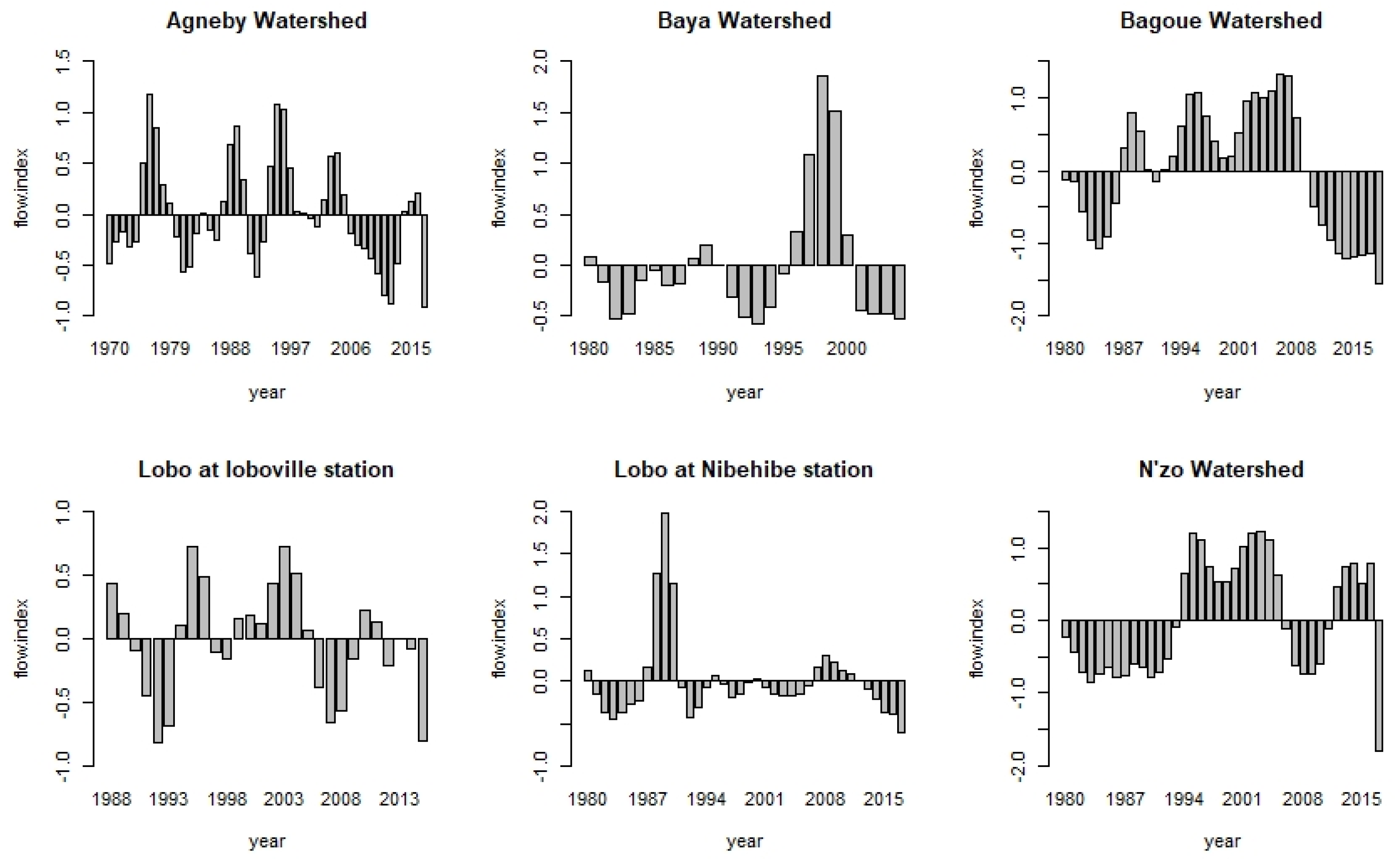
Figure 2 shows the results obtained by applying Hanning’s second-order low-pass filter on the observed discharges. It indicates the great interannual irregularity of the discharges in each climatic zone of the country. All stations studied indicated an alternation of wet periods (surplus zone) and dry periods (deficit zone). The Lobo at Nibehibe and Baya watersheds are more exposed to deficit years, while Bagoue and N’zo watersheds are subject to surplus years. The Agneby watershed and Lobo at Loboville station experience alternating variations in data over time.

3.2. Considering Heterogeneous Periods for the Trend and Breakpoint Analyses

3.2.1. Trend Analysis for High- and Low-Discharge Indices

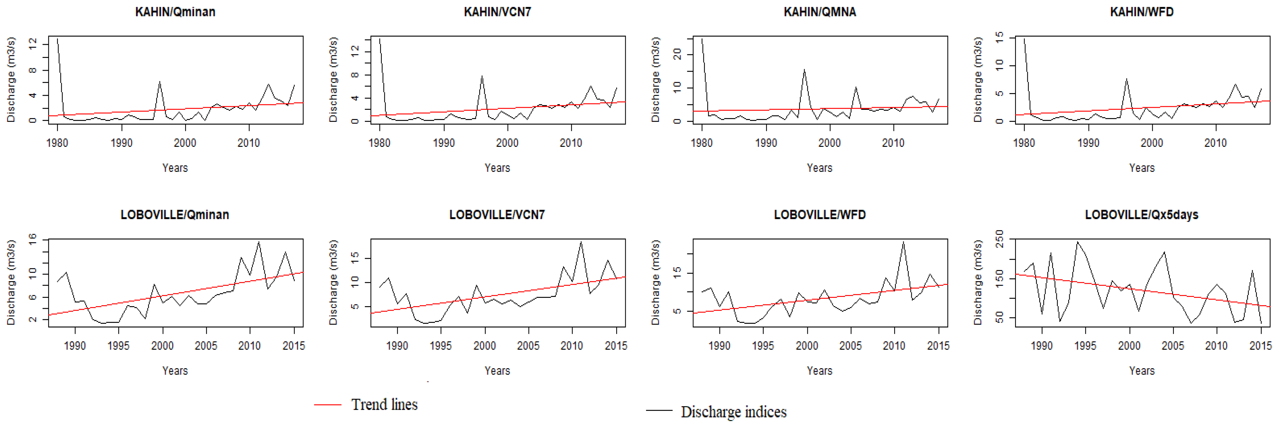
Table 3 shows that only the N’zo at Kahin watershed could experience a flooding problem, with the presence of a significant increasing trend for the VCX30 index. A significant decreasing trend was observed at Loboville station in the Lobo watershed. Regarding drought indices, we also noticed that in four of the study areas (N’zo, Lobo, Bagoue, and Baya) a significant increasing trend was obtained for most of the drought indices. The variables Qminan, QMNA, VCN7, and WDF showed significant upward trends for 33%, 16%, 50%, and 33% of the heterogeneous stations, respectively. Figure 3 shows the plot for the stations and indices, indicating a significant trend of low discharge in this study. The station of Kahin indicated an increasing trend for five of the indices, followed by the station of Loboville, with three indices indicating a significant upward trend.

3.2.2. Breakpoint Detection for High- and Low-Discharge Indices

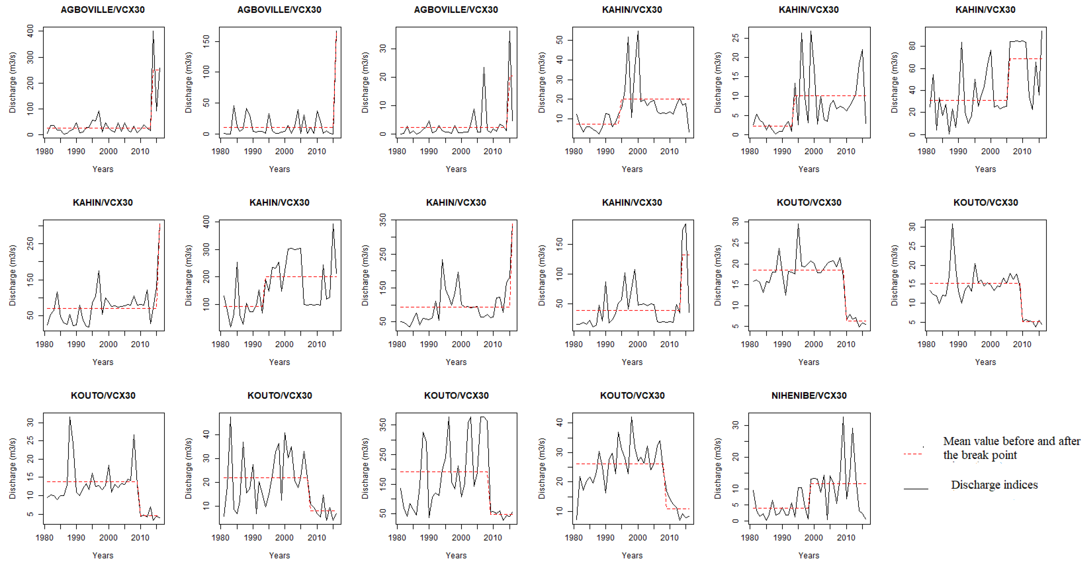
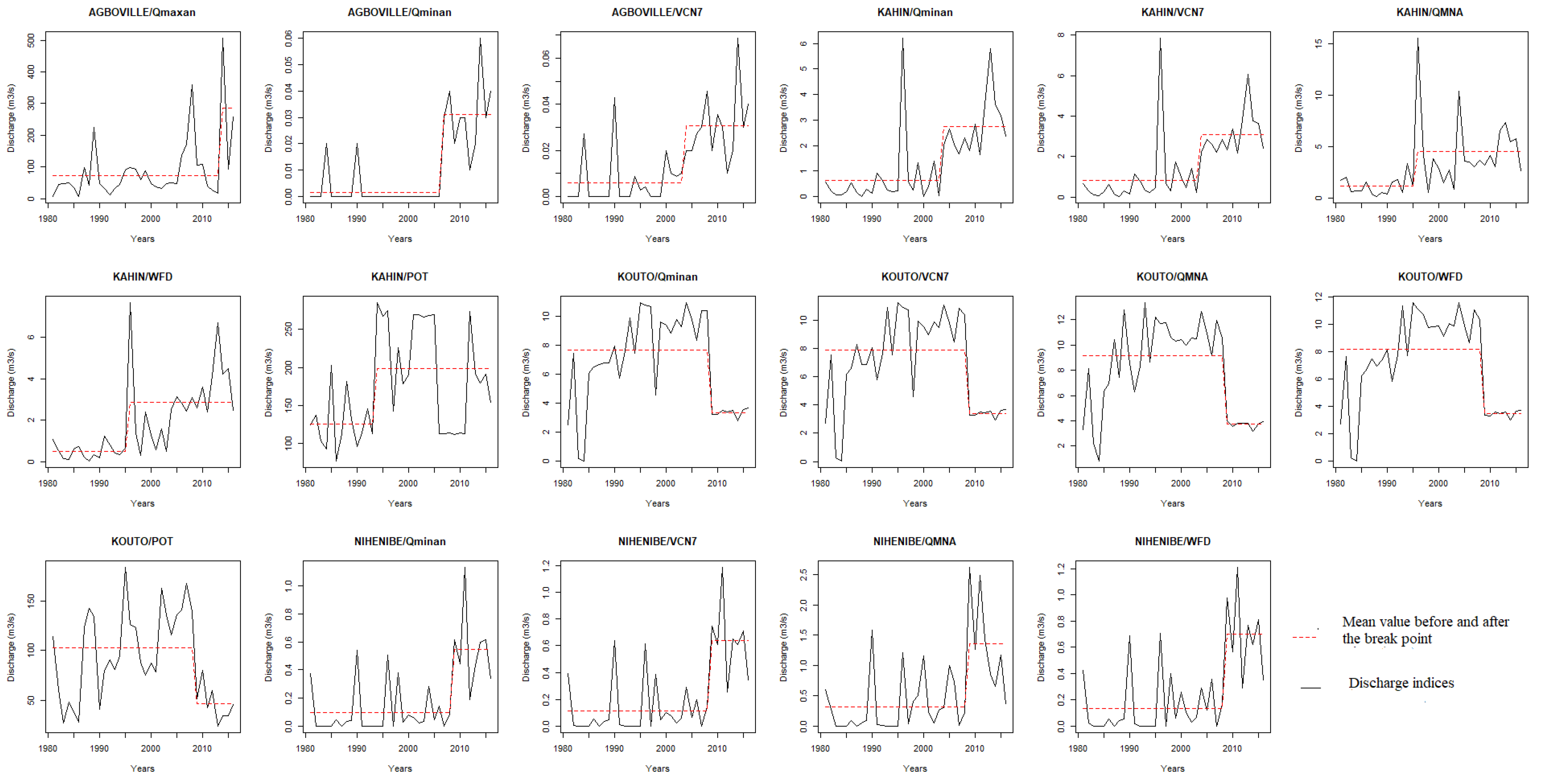
Table 4 summarises the results of the change point computed with the SNHT test for the extreme discharge data. The change points were detected in 1994 at the N’zo watershed; in 1970, 2006, 2013, and 2014 at the Agneby watershed; and in 1984, 1970, and 2012 at the Bagoue watershed with different indices. For the low-discharge indices, all of the study areas experienced great changes in the different indices. For the flood indices, a breakpoint was observed for the variable Qmaxan at the stations of Kouto and Agoville, while for the variable VCX30 this was observed at the stations of Kouto, Agoville, and Kahin. The break point for QX5-days was observed only for the station of Kouto. For all low-discharge indices, breakpoints were found in 1984 at the station of Kouto and in 2008 at the stations of Nibehibe and Loboville. The station of Yebouakro depicted change points in 1980 for the variables Qminan and QMNA. Figure 4 shows the time series of the indices, indicating significant breakpoints for the selected stations. The result of VCX30 was added in Appendix A, as Figure A2.

3.3. Considering Homogeneous Periods for the Trend and Breakpoint Analyses

The results described in Section 3.2 may be dependent on the data length considered. In fact, the data lengths varied from 25 years at the station of Yebouakro to 48 years at the station of Kouto. This section investigated possible differences in the results that could be linked to the changes in the period considered. A common period of 36 years from 1981 to 2016 was considered for the stations of Agboville, Kahin, Nibehibe, and Kouto. The same method applied for the heterogeneous period was used for the homogeneous period.

3.3.1. Trend Analysis Results for Flooding and Low-Discharge Indices

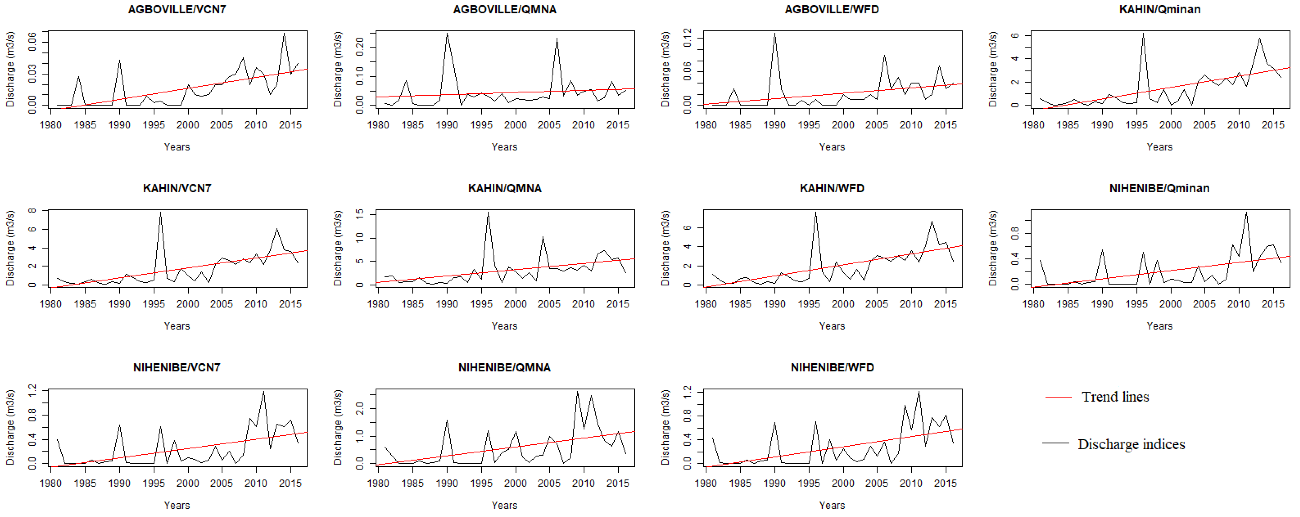
Table 5 displays the trend results for both heterogeneous (- or *) and homogenous (-- or **) periods of data. For the station of Kouto, there was no difference between the results for the two periods for both the flood and low-discharge indices. In fact, no trend was detected for the two periods. Similarly, for the station of Kahin, almost the same trend for the results for the two considered periods was found.
For Nibehibe station, no trend was detected for the heterogeneous period in contrast to the homogeneous period. The results changed for four of the seven indices evaluated at this station, implying that a trend analysis can be highly dependent on the data length considered. Similar results were found for the station of Agboville. For comparison, Figure 5, representing the stations and indices with significant trends for the homogeneous period, is shown.

3.3.2. Breakpoint Detection

Table 6 displays the break points related to the heterogeneous and homogeneous periods for flood indices and low-discharge indices. At the station of Nibehibe, the results for both periods are similar for all indices. In contrast, for the other stations, the results differ substantially between the indices and the years identified as break points. The most remarkable is the station of Kahin, for which only VCX30 shows a break point for the heterogeneous period of data, in contrast to the five indices that show break points for the homogeneous period of data. For comparison purposes, Figure 6, representing the stations and indices with significant break points for the homogeneous period, is shown.

4. Discussion

4.1. High Discharge Rates and Their Implications

The observed data were analysed using the MMK test for all stations first and then for the stations with the same years of observation for the flood and low-water indices. As far as the flood indices were concerned, these different analyses gave a non-significant trend for most of the flood indices, both in the heterogeneous and homogeneous period analyses, with the exception of the VCX30 index at Kahin with a significant upward trend and QX5-days with a decrease trend at Loboville with the heterogeneous data. Thus, whether the data were heterogeneous or homogeneous, the trend detection showed the same effectiveness for the study area. These results may have been due to the high interannual variability observed in the data, as shown by the Hanning test, and the daily impacts of climate change observed across the country, even influencing precipitation. All of the studied watersheds were affected in the same way due to the influence of local climates. Furthermore, this predominance of non-significant changes in the flood variables (i.e., 5-day maximum flow (QX5-days), peak discharge (Qmaxan), maximum monthly discharge (VCX30)) may have been due to the method used. Indeed, the method used is powerful for detecting trends but does not seem to be very robust for the extreme variables because non-significance does not translate into the absence of a trend but rather the incapacity for detection. Ago et al. [40], in their study in Togo and Benin, found no trend despite the method used. The significant breaks in the annual maximum discharge (Qmaxan) and monthly maximum discharge (VCX30) confirmed the results obtained concerning the decrease in maximum discharge for the rivers in Côte d’Ivoire. Indeed, a sudden decrease in the series of extreme maximum discharges could be explained by climatic factors and the variability experienced by these different watersheds, as shown by the result of the Hanning test. Rainfall in Côte d’Ivoire is decreasing in all climatic zones, which affects river discharges, even with the recovery predicted by Nicholson et al. [41]. These flood variables also showed a decreasing trend after their break period, reflecting the general decrease in rainfall recorded in Côte d’Ivoire. These rainfall deficits have been notable in some regions of the country. For example, a 66.5% hydrological deficit in the Bandama discharges at Tortiya was recorded [42], a decrease in rainfall with a deficit of 22% on Agneby was also noted [12], and irregularities in rainfall with direct impacts on the hydrological evolution of the river and on the flood discharges were found for Kahin [43].

4.2. Low Discharge Rates and Their Implications

The results show a general upward trend with the MMK test for the low flow series in all cases considered and especially in the three climatic zones (zone I, zone II, and zone IV), where the local climate and high intervariability are of great importance. This could be explained by the fact that the return of rainfall after the great drought predicted by Nicholson et al. [41] was felt more from the south to the north. This is because the inter-variability influenced by the local climate allows for constant rainfall over the whole territory and at any time of the year, inducing significant trends towards increased river flow in the different catchment areas. Nouaceur et al. [44] concluded in his work that the analysis of the rainfall trend evolution showed that following a long Sahelian drought, rain returned to this part of West Africa. Additionally, [40] concluded that the evolution of the flow of the Mono River remains dependent on climatic factors. These results are in agreement with the work of [45,46]. In addition to these results, a significant break in almost all low-water variables was noted over the same study period. These results confirmed the significant upward trend obtained in low water discharges and confirmed that after the great drought that led to the 1970 break, the rainfall rate experienced a real recovery in all catchment areas studied, as confirmed by the alternating upward and downward trends in the variables after the break. This recovery was certified by many authors [47] who detected disturbances in the N’zo watershed at Kahin in 1993 and 1994, testifying to the wet hydrological recovery in this catchment. Increases in rainfall beyond the new phase (the existence of which it is still premature to affirm), as shown through the rainfall totals, which were close to the average and sometimes even in excess of the daily discharge series from 1954 to 2014 were found in Senegal [48]. The discharges observed in the study area experienced two breaks in the series from 1951 to 2015 in Benin [49].

4.3. Differences in Outputs from Heterogeneous and Homogeneous Periods

As indicated in the result section, there were some differences in the break point and trend analyses for the heterogeneous and homogeneous periods. Some changes that were not found to be statistically significant for the heterogeneous period were found to be statistically significant for the homogeneous period, and vice versa. Similar results were obtained for the Oueme River Basin (Benin) while comparing outputs from homogeneous and heterogeneous periods [50]. This might lead to questions regarding the use of one single period for the break point and trend analyses. It may be interesting in future studies to investigate changes in hydroclimatic variables by considering moving windows.

5. Conclusions

The objective of this work was to analyse trends in hydrological extremes, in particular using flood data with three variables (Qmaxan, VCX30, QX5 days) and low-flow data with four variables (Qminan, QMNA, VCN7, WFD). We obtained non-significant trends for the flood variables in general and significant upward trends for the low-flow variables with the modified Mann–Kendall test (MMK). The detection of breaks using the standard normal homogeneity test (SNHT) indicated a significant break for most of the variables studied in general in all of our different study basins. The methods used provided good results, but for better monitoring and visibility of the impacts of climate change, it would be interesting to extend this analysis to monthly and seasonal scales and to different confidence intervals. This study can help in understanding the behaviour of past hydrological extremes in the study area, although being limited to historical data without being able to identify the causes of the trends were limitations encountered in this study. Therefore, further investigations are needed to verify the hydrological changes revealed by the statistical tests by identifying the physical mechanisms of changes such as rainfall, land use, and agricultural practices and their effects on extreme flows. Additionally, missing data were filled using GR4J, which is a lumped model. This simplifies a watershed into a single homogeneous unit, which is not the case in reality. It can, therefore, under- or overestimate the runoff and impact on the gap filling exercise.

Author Contributions

Conceptualisation, N.J.M.C.A. and G.E.S.; methodology, N.J.M.C.A. and G.E.S.; software, N.J.M.C.A. and J.H.; writing—original draft preparation, N.J.M.C.A.; writing—review and editing, N.J.M.C.A. and J.H.; visualisation, G.E.S.; supervision, G.E.S., T.A.G.B. and A.E.L. All authors have read and agreed to the published version of the manuscript.

Funding

This study was funded by German Ministry of Education and Research (BMBF) through WASCAL Programme (www.wascal.org).

Institutional Review Board Statement

Not applicable.

Informed Consent Statement

Not applicable.

Data Availability Statement

Not applicable.

Acknowledgments

This study is part of a PhD research under the West African Science Service Center on Climate Change and Adapted Land Use (WASCAL) program, done through the Graduate Research Programme on Climate Change and Water Resources at the University of Abomey-Calavi, Republic of Benin. We are grateful to the Direction Générale des Infrastructures Hydrauliques Humaines (DGIHH) of Côte d’Ivoire for providing the data.

Conflicts of Interest

The authors declare no conflict of interest.

Appendix A

Figure A1. Homogeneous break point for VCX30 index.
Hydrology 10 00006 g0a1
Figure A2. Homogeneous period for the trend analysis.
Hydrology 10 00006 g0a2
Figure A3. Homogeneous period for the break point analysis.
Hydrology 10 00006 g0a3

References

  1. Meliho, M.; Khattabi, A.; Jobbins, G.; Sghir, F. Impact of meteorological drought on agriculture in the Tensift watershed of Morocco. J. Water Clim. Change 2019, 11, 1323–1338. [Google Scholar] [CrossRef]
  2. Abdoulaye, B.; Clobite, B.B.; Bell, J.P.; Issak, A.; Robert, M.L.B. Évolution des indices des extrêmes climatiques en République du Tchad de 1960 à 2008. Atmo-Ocean 2017, 55, 42–56. [Google Scholar]
  3. Nyirenda, K.; Emmanuel, S. Trend Analysis of Extreme Rainfall in Zambia and Its Potential Implication on Water Resources Availability and Agricultural Productivity. Am. J. Geochem. Geophys. Geosyst. 2019, 5, 10–15. [Google Scholar]
  4. Botai, C.M.; Joel, O.B.; Nosipho, N.Z.; Patrick, H.; Eric, K.W.; Thabo, M.; Miriam, D.M.; Abiodun, M.A.; Katlego, P.N.; de Wit Jaco, P.; et al. Hydroclimatic Extremes in the Limpopo River Watershed, South Africa, under Changing Climate. Water 2020, 12, 3299. [Google Scholar] [CrossRef]
  5. Attogouinon, A.; Agnidé, E.L.; M’Po, Y.N.; Rita, H. Extreme Precipitation Indices Trend Assessment over the Upper Oueme River Valley-(Benin). Hydrology 2017, 4, 36. [Google Scholar] [CrossRef] [Green Version]
  6. Adeyeri, O.; Ishola, K.; Okogbue, E. Climate change and coastal floods: The susceptibility of coastal areas of Nigeria. J. Coast. Zone Manag. 2017, 20, 443. [Google Scholar]
  7. Abiodun, B.J.; Adegoke, J.; Abatan, A.A.; Ibe, C.A.; Egbebiyi, T.S.; Engelbrecht, F.; Pinto, I. Potential impacts of climate change on extreme precipitation over four African coastal cities. Clim. Change 2017, 143, 399–413. [Google Scholar] [CrossRef]
  8. Mohamed, F.; Julien, A.; Isaac, L.; Jean, H.; Djan’na, K.; Adama, T.; Hamadoun, B.; Sam-Quarcoo, D.; Andrew, M.L. Urban flash flood and extreme rainfall events trend analysis in Bamako, Mali. Environ. Chall. 2022, 6, 100449. [Google Scholar]
  9. Ozer, P.; Ousmane, L.M.; Adamou, D.T.; Bakary, D.; Florence DE, L. Evolution récente des extrêmes pluviométriques au Niger (1950–2014). Geo-Eco-Trop 2017, 41(3), 375–383. [Google Scholar]
  10. Larbi, I.; Fabien, C.C.H.; Thompson, A.; Wilson, A.A.; John, M.G.; Joshua, A. Spatio-Temporal Trend Analysis of Rainfall and Temperature Extremes in the Vea Watershed, Ghana. Climate 2018, 6, 87. [Google Scholar] [CrossRef] [Green Version]
  11. Kouassi, K.M.; Yao, K.B.; Kouassi, K.L.; Biemi, J.; Soro, N. Extreme flow variability analysis at the Bianouan hydrometric station on the Bia River watershed in Côte d’Ivoire. Proc. IAHS 2020, 383, 319–325. [Google Scholar] [CrossRef]
  12. Assoma, V.T.; Adiaffi, B.; Koudou, A. Influence de la Variabilité Climatique sur les Réserves en eau du sol et dans les Systèmes Agricoles du Bassin Côtier de l’Agnéby (Côte d’Ivoire). Eur. J. Scie. Res. 2016, 143, 186–202. [Google Scholar]
  13. Assoko, A.V.S.; Kouassi, A.M.; Nassa, R.A.K. Modélisation statistique des débits d’étiages et détermination de seuils d’étiages dans le bassin versant de la marahoué (bandama, côte d’ivoire). Larhyss J. 2020, 41, 121–147. [Google Scholar]
  14. RNC, 2021: Rapport des Consultations Nationales en Côte D’Ivoire. p. 80. Available online: https://www.floodmanagement.info (accessed on 5 December 2022).
  15. Affoué, B.Y.; Bi Tié Albert, G.; Alioune, K.; Oi, M.J.M.; Kouamé, A.K. Cartographie du potentiel en eau souterraine du bassin versant de la Lobo (Centre-Ouest, Côte d’Ivoire): Approche par analyse multicritère. Hydrol. Sci. J. 2016, 61, 856–867. [Google Scholar]
  16. Deguy, A.J.-P. Evaluation de la Vulnérabilité à l’Érosion Hydrique des Sols du Bassin Versant de la Lobo (Côte d’Ivoire): Approche par Modélisations. Ph.D. Thesis, Géosciences et Environnement, Université de Nangui Abrogoua, Abidjan, Côte d’Ivoire, 2021; p. 238. [Google Scholar]
  17. Adja, M.G.; Djémin, E.J.; N’Dri Franck, A.; Tohouri, P.; Kouamé, K.J.; Jourda, J.P. Apport de l’Analyse Hydrologique et de la Modélisation de la Relation Pluie-Débit dans le Suivi Quantitatif des Ressources en Eau dans un Contexte de Variabilité Climatique: Cas du Sous-Bassin Versant du Kouto (Nord de la Côte d’Ivoire). Eur. J. Sci. Res. 2019, 154, 192–212. [Google Scholar]
  18. Coulibaly, K.A. Impacts de la Variabilité Récente de la Pluviométrie sur les Paramètres Agroclimatiques Majeurs et les Calendriers Agricoles pour une Corrélation avec le Système Couplé Océan-Atmosphère en Côte D’Ivoire. Ph.D. Thesis, Géographie, Université Félix Houphouët-Boigny, Abidjan, Cote D’Ivoire, 2021; p. 360. [Google Scholar]
  19. Ehuitché, B.T. An analysis of dynamics of deforestation and agricultural productivity in Côte d’Ivoire. Inter. Res. J. Agric. Sci. Soil Scie. 2015, 5, 103–111. [Google Scholar]
  20. Goula, A.B.T.; Gneneyougo Soro, E.; Kouassi, W.; Srohourou, B. Tendances et ruptures au niveau des pluies journalières extrêmes en Côte d’Ivoire (Afrique de l’Ouest). Hydrol. Sci. J. 2012, 57, 1067–1080. [Google Scholar] [CrossRef] [Green Version]
  21. Tyson, P.D.; Dyer, T.G.; Mametse, M.N. Security changes in South African rainfall: 1880 to 1972. Q. J. R. Meteorol. Soc. 1975, 101, 817–833. [Google Scholar] [CrossRef]
  22. Blé, A.F.Y.; Emile, G.S. Detection of Hydrologic Trends and Variability in Transboundary Cavally Watershed (West Africa). Am. J. Water Res. 2021, 9, 92–102. [Google Scholar] [CrossRef]
  23. Yao, A.B. Evaluation des Potentialités en eau du Bassin Versant de la Lobo en Vue d’Une Gestion Rationnelle (Centre-Ouest de la Côte d’Ivoire). Ph.D. Thesis, Université Nangui Abrogoua, Abidjan, Côte d’Ivoire, 2015; 330p. [Google Scholar]
  24. Maochuan, H.; Takahiro, S.; Weili, D.; Kaoru, T.; Bin, H.; Pingping, L. Assessment of hydrological extremes in the Kamo River Basin, Japan. Hydrolog. Sci. J. 2017, 62, 1255–1265. [Google Scholar] [CrossRef]
  25. Kouassi, A.M.; Koffi, Y.B.; Nassa, R.A.K.; Kouame, K.F.; Biemi, J. Prévision saisonnière des débits de basses eaux au sein des bassins fluviaux de l’afrique de l’ouest: Cas du bassin versant du n’zi-bandama, Côte D’Ivoire. Rev. Ivoir. Sci. Technol. 2018, 32, 153–171. [Google Scholar]
  26. Gailliez, S. Low Discharge Discharge Estimation at Ungauged Sites. Application in Walloon Region. Ph.D. Thesis, Université of Liège, Liège, Belgium, 2013; p. 272. [Google Scholar]
  27. Garcia, F. Amélioration d’Une Modélisation Hydrologique Régionalisée Pour Estimer Les Statistiques D’Etiage. Ph.D. Thesis, Université Pierre et Marie Curie, Paris, France, 2016; p. 273. [Google Scholar]
  28. Anouman, D.G.-L.; N’go, Y.A.; Soro, G.E.; Bi, T.A.G. Spatial and Temporal Evolution of Low Water Discharges in the Sassandra River Watershed Area in Côte d’Ivoire. J. Geo Environ. Protec. 2019, 7, 184–202. [Google Scholar] [CrossRef] [Green Version]
  29. Piniewski, M.; Marcinkowski, P.; Kundzewicz, Z.W. Trend detection in river flow indices in Poland. Acta Geophys. 2018, 66, 347–360. [Google Scholar] [CrossRef] [Green Version]
  30. Lang, C. Les Étiages: Définitions Hydrologique, Statistique et Seuils Réglementaires. Cybergeo Eur. J. Geogr. Environ. Nat. Paysage; Mis en Ligne le 30 Novembre 2011. Available online: http//journals.openedition.org/cybeo/24827 (accessed on 5 December 2022).
  31. Hamed, K.H.; Rao, A.R. A modified Mann–Kendall trend test for autocorrelated data. J. Hydrol. 1998, 204, 82–196. [Google Scholar] [CrossRef]
  32. Sandeep, K.P.; O’Br, N. Modifiedmk: Modified Versions of Mann Kendall and Spearman’s Rho Trend Tests, 2021. R Package Version 1.6. Available online: https://cran.r-project.org/web/packages/modifiedmk/modifiedmk.pdf (accessed on 5 December 2022).
  33. Ilori, O.W.; Ajayi, V.O. Change Detection and Trend Analysis of Future Temperature and Rainfall over West Africa. Earth Syst. Environ. 2020, 4, 493–512. [Google Scholar] [CrossRef]
  34. Gadedjisso, T.A.; Adjegan, K.I.; Kablan, A.K.M. Rainfall and Temperature Trend Analysis by Mann–Kendall Test and Significance for Rainfed Cereal Yields in Northern Togo. Science 2021, 3, 17. [Google Scholar] [CrossRef]
  35. Javari, M. Trend and Homogeneity Analysis of Precipitation in Iran. Climate 2016, 4, 44. [Google Scholar] [CrossRef] [Green Version]
  36. Hänsel, S.; Medeiros, D.M.; Matschullat, J.; Petta, R.A.; De Mendonça, S.I. Assessing Homogeneity and Climate Variability of Temperature and Precipitation Series in the Capitals of North-Eastern Brazil. Front. Earth Sci. 2016, 4, 29. [Google Scholar] [CrossRef] [Green Version]
  37. Traore, V.B.; Giovani, M.; Sarr, J.; Diaw, A.T. Detection of inhomogeneities and break points in annual detection of inhomogeneities and break points in annual rainfall series of Senegal regions trend assessment over the upper oueme river valley-(Benin). Hydrology 2018, 4, 36. [Google Scholar]
  38. Jenifer, M.A.; Jha, M.K. Assessment of precipitation trends and its implications in the semi-arid region of Southern India. Environ. Chall. 2021, 5, 100269. [Google Scholar] [CrossRef]
  39. Thorsten Pohlert Trend: Non-Parametric Trend Tests and Change-Point Detection. 2020. R Package Version 1.1.4. Available online: https://CRAN.R-project.org/package=trend (accessed on 5 December 2022).
  40. Ago, E.; Petit, F.; Ozer, P. Analysis of flood downstream from the Nangbeto dam on the Mono River (Togo and Benin). Geo-Eco-Trop 2005, 29, 1–14. [Google Scholar]
  41. Nicholson, S.E.; Some, B.; Kone, B. An Analysis of Recent Rainfall Conditions in West Africa, Including the Rainy Seasons of the 1997 El Nino and the 1998 La Nina Years. J. Clin. 2000, 13, 2628–2640. [Google Scholar] [CrossRef]
  42. Kamagaté, A.; Koffi, Y.; Kouassi, A.; Kouakou, B.; Seydou, D. Impact des Évolutions Climatiques sur les Ressources en eau des Petits Bassins en Afrique Sub-Saharienne: Application au Bassin Versant du Bandama à Tortiya (Nord Côte d’Ivoire). Eur. Sci. J. 2019, 15, 10. [Google Scholar] [CrossRef]
  43. Anouman, D.G.-L. Etude Hydroclimatique et Morphostructurale du Bassin Versant du Sassandra: Influence sur les Aleas Crue et Tarissement des Cours d’Eau. Ph.D. Thesis, Université Nangui Abrogoua, Abidjan, Côte d’Ivoire, 2020; p. 234. [Google Scholar]
  44. Nouaceur, Z.; Murarescu, O. Rainfall Variability and Trend Analysis of Rainfall in West Africa (Senegal, Mauritania, Burkina Faso). Water 2020, 12, 1754. [Google Scholar] [CrossRef]
  45. Siou, L.K.A. Méthodologie de caractérisation et d’évaluation des débits d’étiages. Appl. Bassin Bani 2008, 59, 77. [Google Scholar]
  46. Amogu, O.; Descroix, L.; Yéro, K.S.; Le Breton, E.; Mamadou, I.; Ali, A.; Vischel, T. Increasing River Discharges in the Sahel? Water 2010, 2, 170–199. [Google Scholar] [CrossRef] [Green Version]
  47. Goula, B.T.A.; Savane, I.; Konan, B.; Fadika, V.; Kouadio, G.B. Impact de la variabilité climatique sur les ressources hydriques des bassins de N’Zo et N’Zi en Côte d’Ivoire (Afrique tropicale humide). Vertigo 2006, 1, 1–12. [Google Scholar] [CrossRef]
  48. Faye, C. Variabilité et tendances observées sur les débits moyens mensuels, saisonniers et annuels dans le bassin de la Falémé (Sénégal). Hydrol. Sci. J. 2017, 62, 259–269. [Google Scholar] [CrossRef]
  49. Kodja, D.J.; Mahe, D.; Vissin, G.; Amoussou, E.; Paturel, E.; Houndenou, J.-E.; Boko, C. Etude des indices de débits journaliers extrêmes a l’inondation dans le bassin versant de l’ouémé à l’exutoire de bonou. In Proceedings of the XXXème Colloque de l’Association Internationale de Climatologie, Sfax, Tunisia, 3–6 July 2017. [Google Scholar]
  50. Hounkpè, J.; Diekkrüger, B.; Badou, D.; Afouda, A. Change in Heavy Rainfall Characteristics over the Ouémé River Basin, Benin Republic, West Africa. Climate 2016, 4, 15. [Google Scholar] [CrossRef]
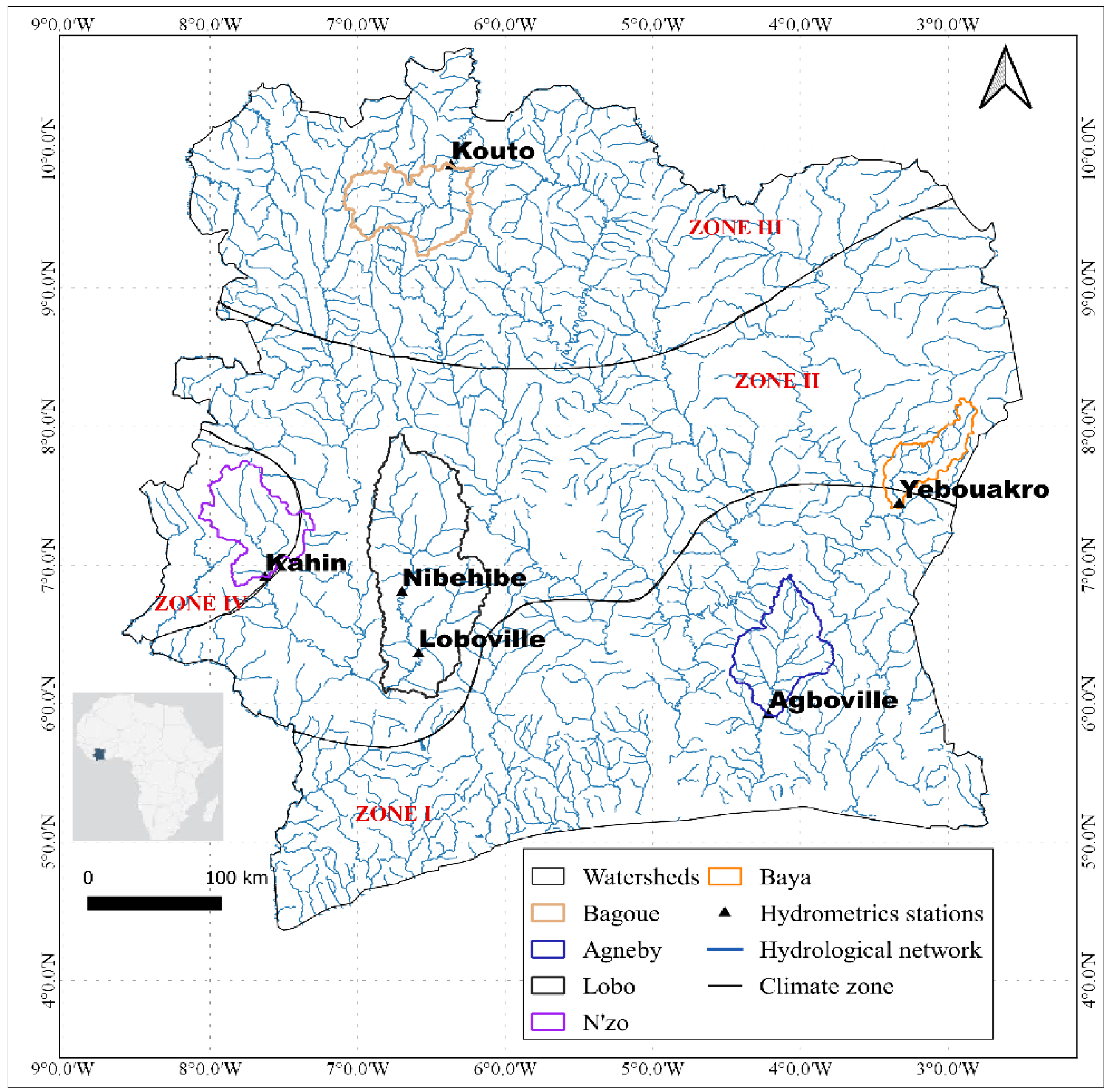
Figure 1. Locations of the five selected watersheds within the different climatic zones in Côte d’Ivoire.
Hydrology 10 00006 g001
Figure 2. Interannual variations in discharge in each watershed using the non-recursive low-pass Hanning filter of order 2.
Hydrology 10 00006 g002
Figure 3. Stations and indices indicating significant trends (Qminan, QMNA, VCN7, WFD, and QX5-days) in the selected river watersheds in Côte d’Ivoire.
Hydrology 10 00006 g003
Figure 4. Significant break points in the selected watersheds in Côte d’Ivoire.
Hydrology 10 00006 g004
Figure 5. Significant trend results for the homogeneous stations.
Hydrology 10 00006 g005
Figure 6. Significant break result for the homogeneous stations.
Hydrology 10 00006 g006
Table 1. Characteristics of the selected watersheds.
Climate
Zone
WatershedsArea
(km2)
ClimateCharacteristics
Zone II
Equatorial transitional regime
Attenuated (Baouleen climate)
Baya2266.6watershed belongs to the humid tropical climate
-
maximum annual rainfall of 1200 m
-
seasons divided between a largely dry season (November–March) characterised by the harmattan, a large rainy season (April–June), and a small dry season (July–August)
Lobo12,660transitional equatorial type
watershed belongs to the sub-equatorial climate
-
rainy season from March to October and a dry season from November to February
-
average annual rainfall of 1238.2 mm.
Zone III
Transitional tropical regime
(Sudanese climate)
Bagoue4825.7soudano-guineensingle rainy season from April–May to October
Zone IV
Mountain
regime
N’zo4458.6Mountain
characterised by two seasons: a long rainy season lasting 8 months and a dry season of 4 months
-
two main seasons of unequal duration
-
annual rainfall between 1600 and 2000 mm
Zone I
Transitional equatorial regime transitional (Attieen climate)
Agneby8420equatorial transition
-
four seasons: two dry seasons (December–March and July–September) and two rainy seasons (April–July, which is more important, and September–November, which is very irregular)
-
annual rainfall between 1400 and 2500 mm/year
Table 2. Extreme discharge indices (m3/s).
IndexNameDefinition
QX5-days5-day maximum flowMoving average of maximum discharge rate over five days.
QmaxanPeak dischargeAnnual maximum discharge
VCX30Mean monthly dischargemaximum average discharge over 30 consecutive days
QminanAnnual minimum dischargesThe lowest discharge value of the year
QMNAAverage monthly dischargesThe lowest average monthly discharge for the year
VCN7Daily discharge rateMoving average discharge rate over seven days.
WFDCharacteristic of low dischargeThe discharge rate equals or does not exceed 10 days per year.
Table 3. A trend analysis of flood index (Qmaxan, VCX30, and POT) and low-discharge index (Qminan, QMNA, VCN7, and WFD) values in some watersheds in Côte d’Ivoire.
Trend (MMK Test)
High-Discharge IndicesLow-Discharge Indices
WatershedsPeriod of AnalysisStationsQmaxanVCX30QX5-daysQminanQMNAVCN7WDF
Agneby1970–2017Agboville-------
N’zo1980–2017Kahin-**-********
Lobo1988–2015Loboville--***-****
1980–2017Nibehibe-------
Bagoe1980–2018Kouto-------
Baya1980–2004Yebouakro-------
Note: ** indicates an increasing trend; ‘-‘indicates a non-significant trend; * indicates a decreasing trend.
Table 4. Break point detection related to flood and low-discharge indices in some watersheds in Côte d’Ivoire for the period 1980–2017.
Watershed Flood IndicesLow-Discharge Indices
PeriodStationsQmaxanVCX30QX5-DaysQminanQMNAVCN7WDF
Bagoe1970–2017Kouto2012 *2008 *1970 *1984 *1984 *1984 *1984 *
Agneby1980–2017Agboville2013 *2014 *-2006 *--1970 *
Lobo1988–2015Nibehibe---2008 *2008 *2008 *2008 *
1980–2017Loboville---2008 *2008 *2008 *2008 *
N’zo1980–2018Kahin-1994 *-----
Baya1980–2004Yebouakro---1980 *1980 *--
Note: * indicates a significant break; ‘-’ indicates a non-significant break.
Table 5. A trend analysis for the heterogeneous and homogeneous stations of flood and low-discharge indices in some watersheds in Côte d’Ivoire.
Trend (MMK Test)
High-Discharge IndicesLow-Discharge Indices
WatershedsPeriod of AnalysisStationsQmaxanVCX30QX5-DaysQminanQMNAVCN7WDF
Agneby1981–2016Agboville-
--
-
--
-
--
-
--
-
**
-
**
-
**
N’zo1981–2016Kahin-
--
*
--
-
**
*
**
*
**
*
**
*
**
Lobo1981–2016Nibehibe-
--
-
--
-
-
-
**
-
**
-
**
-
**
Bagoe1981–2016Kouto-
--
-
--
-
--
-
--
-
--
-
--
-
--
Note: * and ** indicate increasing trends for the heterogeneous and homogeneous stations, respectively; - and -- indicate non-significant trends for the heterogeneous and homogeneous stations, respectively.
Table 6. Break point detection related to the heterogeneous and homogeneous periods for flood indices and low-discharge indices in the selected river watersheds in Côte d’Ivoire for the period 1981–2016.
Watershed Flood IndicesLow-Discharge Indices
Period of AnalysisStationsQmaxanVCX30QX5-days QminanQMNAVCN7WDF
Bagoe1981–2016Kouto2012 *2008 *2008 **1984 *1984 *1984 *1984 *
2008 **2008 **2008 **2008 **
Agneby1981–2016Agboville2013 *2014 * 2006 * 2003 **1970 *
2013 **2006 **
Lobo1981–2016Nibehibe 2008 *2008 *2008 *2008 *
2008 **2008 **2008 **2008 **
N’zo1981–2016Kahin 1994 *1993 **2002 **1995 **2002 **1995 **
Note: * and ** indicate significant breaks for the heterogeneous and homogeneous periods, respectively.
Disclaimer/Publisher’s Note: The statements, opinions and data contained in all publications are solely those of the individual author(s) and contributor(s) and not of MDPI and/or the editor(s). MDPI and/or the editor(s) disclaim responsibility for any injury to people or property resulting from any ideas, methods, instructions or products referred to in the content.