1. Introduction
Semiconductor optoelectronic LiDAR sensors are core optoelectronic devices for environmental perception of mobile robots, whose signal processing and positioning algorithms directly determine device application performance. Autonomous localization technology is the core enabler for mobile robots to perform tasks such as inspection, navigation, and autonomous charging in unstructured environments [
1]. According to the dependence on prior environmental information, localization methods are categorized into map-free localization and prior map-based localization [
2]. Map-free localization, typically implemented via Simultaneous Localization and Mapping (SLAM), achieves real-time navigation by incrementally constructing maps while estimating poses [
3]. Graph-based SLAM methods, as representative map-free techniques, offer high-precision trajectory and map estimation with excellent consistency and robustness [
4]. However, the computational complexity of loop closure detection and global graph optimization results in a map update frequency below 1 Hz, which fails to meet the real-time requirements of high-dynamic mobile robot applications [
5].
In contrast, prior map-based localization methods achieve fast and high-precision pose estimation by matching sensor data with pre-constructed high-precision maps, significantly reducing computational overhead and improving real-time performance [
6]. Mobile robot localization can be further divided into local positioning and global positioning [
7]. Local positioning assumes a known initial pose and updates incrementally using sensor data, while global positioning determines the robot’s pose in the global coordinate system without prior pose information, which also involves relocalization to recover positioning after drift or loss [
8]. The reliability of relocalization directly affects the safety and autonomy of robots in long-term missions [
9].
Existing global positioning methods for mobile robots include external marker-based (GPS, WiFi, and UWB), visual scene recognition-based, neural network-based, map matching-based, and Monte Carlo Localization (MCL) methods [
10]. External marker-based methods provide global poses but are environment-dependent: GPS is ineffective indoors, while WiFi/UWB require additional infrastructure, leading to high deployment costs [
11]. Visual-based methods utilize cameras or LiDAR to identify environmental features with high precision but are susceptible to illumination changes and occlusions [
12]. Neural network-based methods exhibit strong adaptability but rely on large-scale labeled training data [
13]. Map matching-based methods depend on high-precision maps and are suitable for scenarios with minimal environmental changes [
14]. MCL methods achieve positioning based on probability distributions with good adaptability but suffer from high computational complexity [
15].
Local positioning technologies include odometry, inertial navigation (IMU), LiDAR odometry, visual odometry (VO), and multi-sensor fusion [
16]. Odometry- and IMU-based methods are prone to cumulative errors and long-term drift [
17]. LiDAR and VO methods estimate poses via feature matching but encounter significant errors in textureless or dynamic scenes [
18]. To enhance system robustness, multi-sensor fusion has become a research focus in recent years, integrating IMU, LiDAR, and cameras to complement each other’s advantages [
19].
Despite these advancements, existing methods still face critical challenges: (1) LIO-based methods lack global constraints, leading to cumulative drift in long-term operation; (2) prior map-based methods are unstable in dynamic or feature-sparse environments due to unreliable feature matching; (3) most systems lack efficient failure detection and relocalization mechanisms, resulting in poor adaptability to complex scenarios [
20]. The semiconductor optoelectronic LiDAR sensor used in this work is a solid-state or hybrid solid-state ranging device based on direct time-of-flight (dToF) or amplitude-modulated continuous-wave (AMCW) measurement principles, realizing three-dimensional environmental perception through a semiconductor laser emitter (wavelength typically 905 nm or 1550 nm) combined with an avalanche photodiode (APD) or single-photon avalanche diode (SPAD) receiver array. Compared with traditional rotating mechanical LiDAR, this type of sensor exhibits a smaller form factor, lower power consumption, and higher integration, but also presents distinct signal-noise characteristics: (1) single-photon detection sensitivity leads to shot-noise-dominated range measurement with standard deviation typically in the range
–
under normal ambient light conditions; (2) multi-path interference and glass-surface specular reflection can generate ghost returns, requiring robust outlier filtering at the pre-processing stage; (3) the non-uniform angular resolution across the field of view (denser near the center, sparser at edges) affects feature extraction density and must be accounted for in adaptive threshold design. The RS-Helios-16P device employed in this study operates at 905 nm, with a ranging accuracy of
(
) and a range noise standard deviation of
, which directly governs the residual weighting strategy for LiDAR measurement residuals.
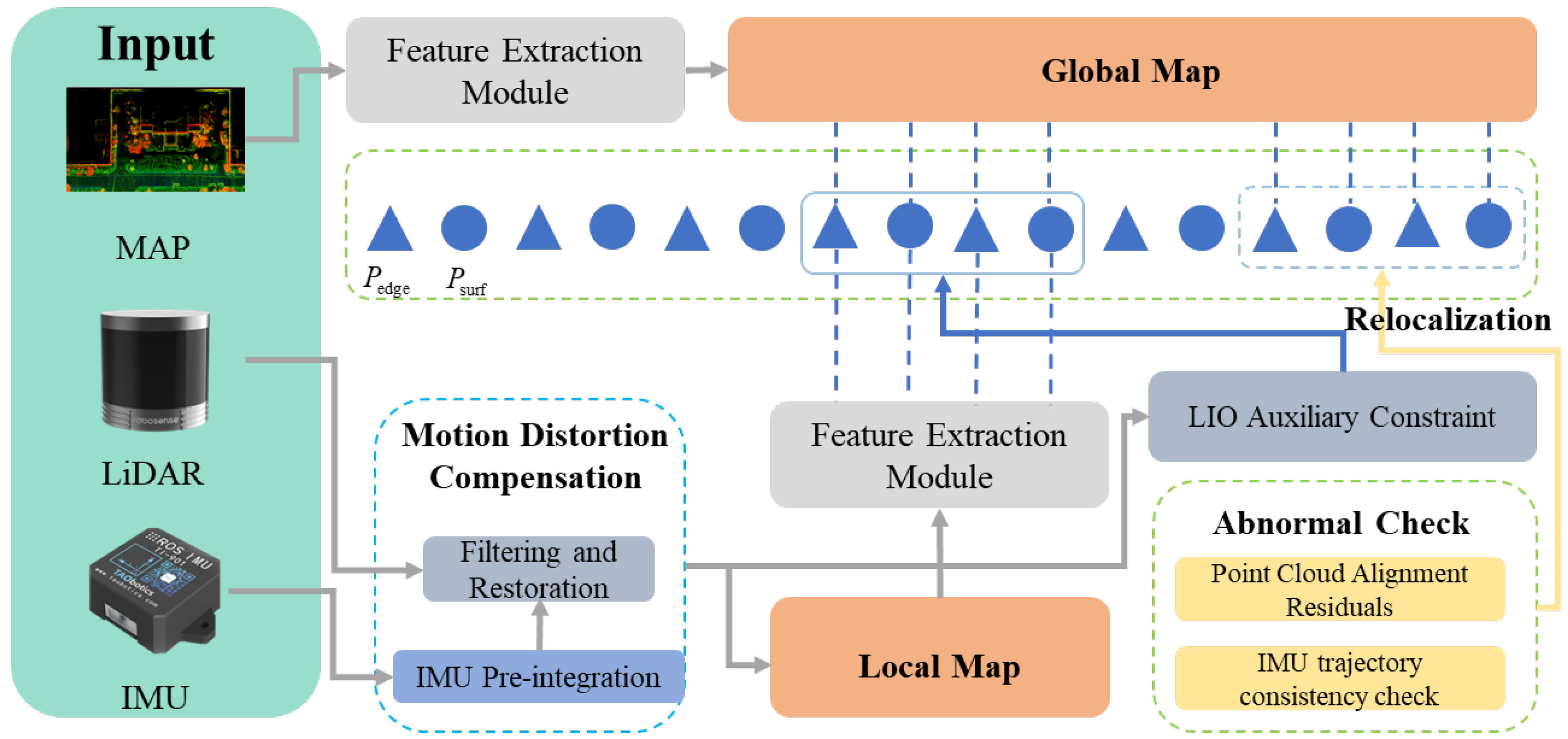
To address these issues and optimize the perception performance of semiconductor optoelectronic LiDAR devices, this paper proposes a high-robustness LiDAR-IMU positioning system integrating prior map constraints and LIO optimization, whose overall pipeline is illustrated in
Figure 1. The main contributions of this work are threefold:
- (1)
A prior map constraint framework is proposed, where a high-precision global map constructed by LIO-SAM is utilized to introduce map optimization terms. By precisely matching edge and planar features, cumulative drift during long-term operation is effectively suppressed, and the global consistency of pose estimation is improved.
- (2)
A LiDAR-IMU tightly coupled optimization strategy is designed based on a factor graph framework. IMU pre-integration and LiDAR feature matching residuals are jointly optimized, ensuring high-precision and low-latency pose estimation even in high-dynamic environments.
- (3)
An adaptive failure detection and relocalization mechanism is developed. A dual-index anomaly detection strategy (residual monitoring + pose jump detection) identifies localization failures in real time, and a BoW-based global matching method combined with RANSAC geometric verification achieves fast and accurate relocalization, significantly enhancing the system’s robustness in complex scenarios.
5. Discussion
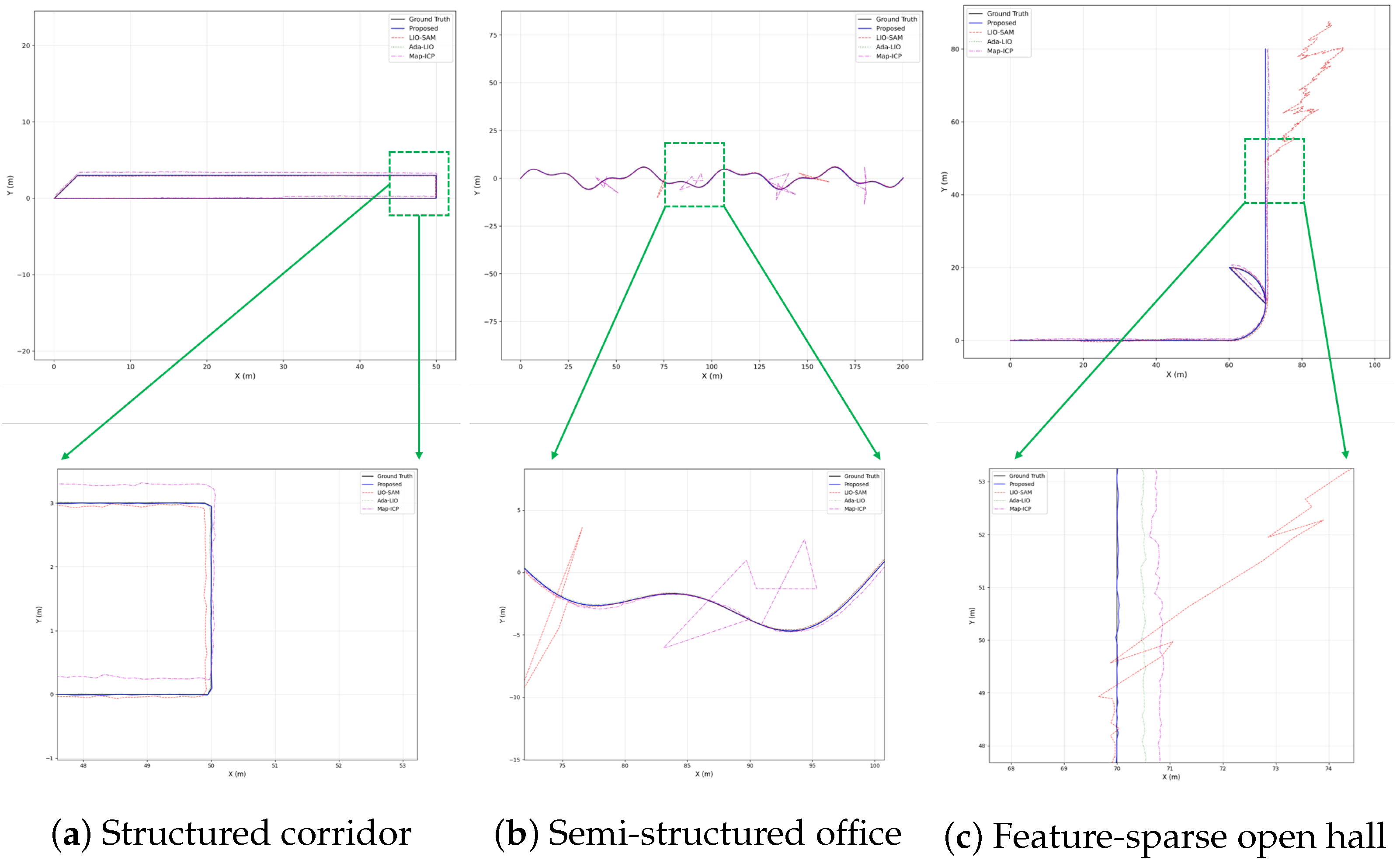
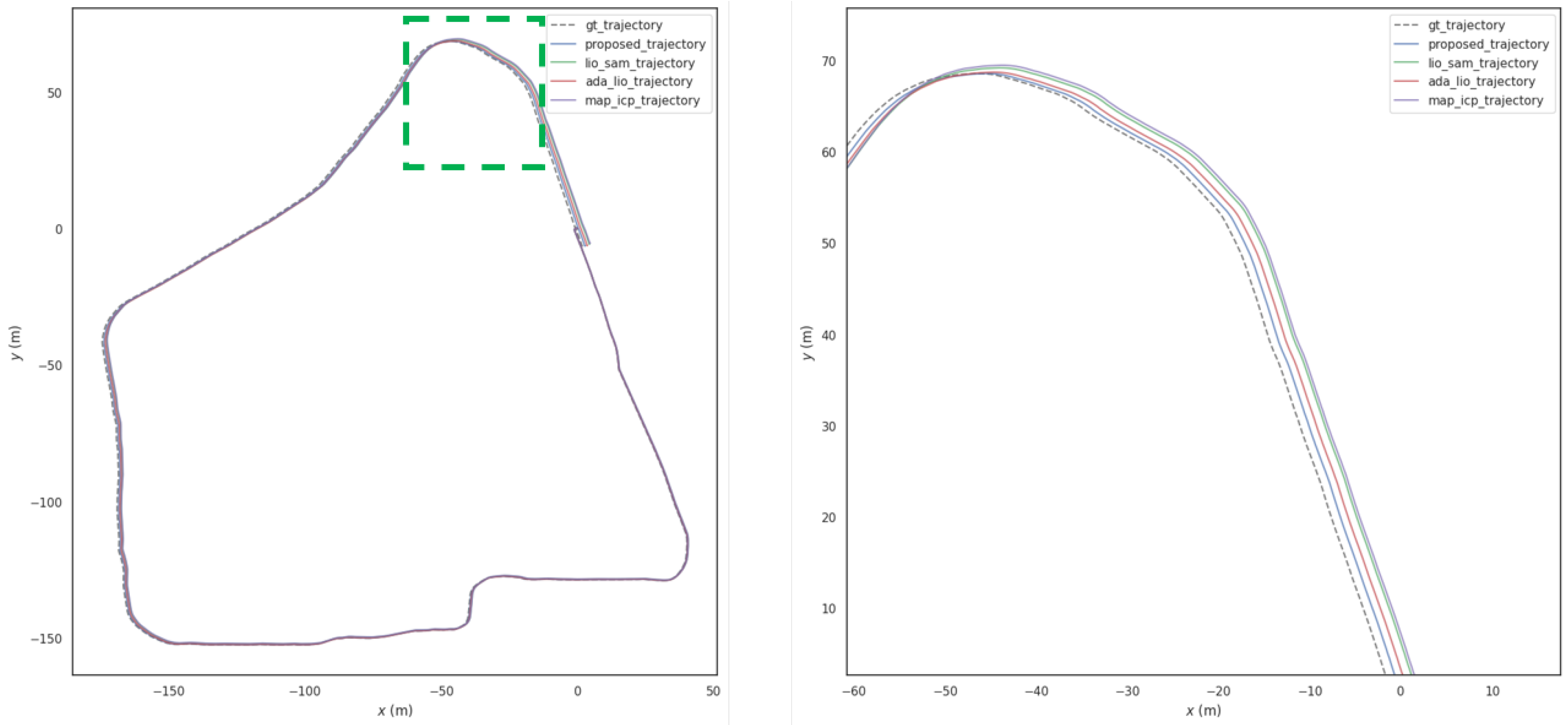
The experimental results from both simulation and physical validation consistently demonstrate that the proposed LiDAR-IMU tightly coupled positioning system integrating prior map constraints and adaptive relocalization mechanism outperforms state-of-the-art methods across all critical performance metrics, including accuracy, long-term robustness, anomaly recovery, and real-time operation.
A key insight is the synergy between prior map constraints and LiDAR-IMU tight coupling: the prior map provides global reference to suppress cumulative drift, while the high-frequency IMU pre-integration compensates for LiDAR sampling gaps, balancing global consistency and local dynamic responsiveness. This effectively solves the problem of unbounded drift in traditional LiDAR-IMU tight coupling methods and the poor dynamic performance of prior map-based registration methods.
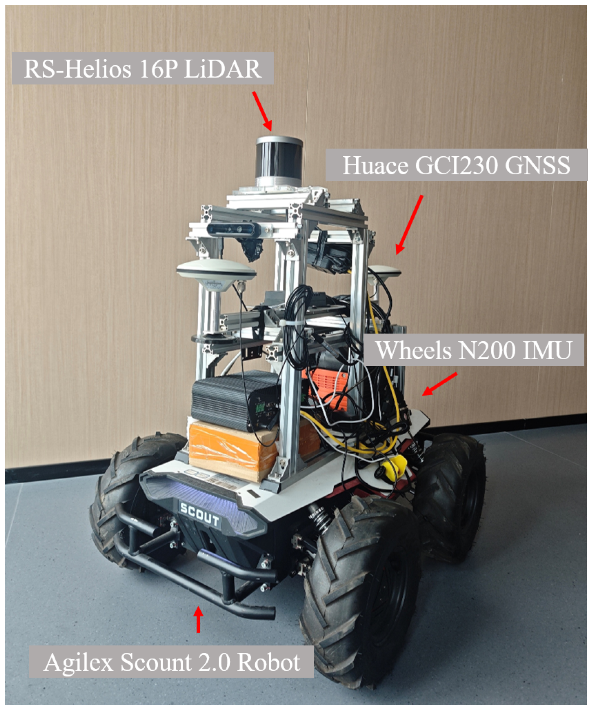
The dual-index anomaly detection strategy and BoW-based relocalization mechanism enable the system to quickly identify and recover from positioning failures in feature-sparse environments, which is a critical advantage over comparative methods that lack dedicated relocalization capabilities. Additionally, the adaptive feature extraction and lightweight optimization strategies ensure that the system can operate in real time on resource-constrained mobile platforms (e.g., Scount 2.0), enhancing its practical application value.
Limitations of this work include the following: (1) Simulation experiments did not consider extreme sensor failures (e.g., LiDAR disconnection, sudden IMU bias changes). (2) The static prior map cannot adapt to slow environmental changes (e.g., furniture movement). (3) Physical experiments were limited to 1-h operation, and 24-h long-term stability requires further validation. Future research directions will focus on developing dynamic map update mechanisms, optimizing anomaly detection thresholds using reinforcement learning, integrating visual sensors to supplement texture features in sparse environments, and exploring lightweight algorithms for embedded platform deployment. The proposed system effectively improves the practical service performance and environmental adaptability of semiconductor optoelectronic LiDAR perception devices.
6. Conclusions
To address cumulative drift, poor dynamic adaptability, and inadequate failure recovery in existing LiDAR-IMU localization methods, this paper proposes a tightly coupled positioning system integrating prior map constraints and an adaptive relocalization mechanism. Comprehensive simulation and physical experiments demonstrate that the proposed system outperforms state-of-the-art methods (LIO-SAM, Ada-LIO, and Map-ICP), achieving an ATE RMSE of 0.062 m, a cumulative drift of 0.09 m per 100 m, a 92% relocalization success rate in feature-sparse scenes, and real-time operation (23.2 ms per frame) on resource-constrained platforms; the system balances global consistency, dynamic responsiveness, and real-time performance. This work provides a high-performance signal processing and pose estimation scheme for semiconductor optoelectronic LiDAR sensing systems, which can support reliable autonomous perception in complex real-world environments.