Article

Natural and Anthropogenic Influence on the Physicochemical Characteristics of Spring Water: The Case Study of Medvednica Mountain (Central Croatia)

Department of Geography, Faculty of Science, University of Zagreb, Trg Marka Marulića 19/II, 10000 Zagreb, Croatia
*
Author to whom correspondence should be addressed.
Limnol. Rev. 2025, 25(3), 36; https://doi.org/10.3390/limnolrev25030036 (registering DOI)
Submission received: 8 July 2025 / Revised: 21 July 2025 / Accepted: 23 July 2025 / Published: 1 August 2025

Abstract

During the period from 2020 to 2024, 900 springs were mapped on the southern slopes of Medvednica Mountain Nature Park. Physicochemical parameters (temperature, pH, and electrical conductivity) were measured at 701 of these springs using a portable multimeter, and results were analyzed in relation to local lithology and human activities. This research provides the first results of this kind in this study area, aiming to expand the knowledge on local springs and to support the future protection and management of spring ecosystems. Springs on the Medvednica mountain showed substantial variation in measured parameters. The temperature ranged from 3.4 to 18.9 °C, reflecting local hydrological conditions, aquifer characteristics, and seasonal variability. Electrical conductivity (EC) ranged between 41 μS/cm and 2062 μS/cm, determined by both hydrogeological settings and anthropogenic impacts such as winter road salting. The pH values showed moderate variability, remaining mostly within neutral levels. These results emphasize the importance of continued monitoring and further research of Medvednica springs, in order to highlight their importance and to preserve their ecological and hydrological roles.

Graphical Abstract

1. Introduction

Springs are places of great importance to humans, but their ecological significance also has to be emphasised. They are regarded as very important and sensitive ecosystems [1,2,3,4,5]. Although the term spring is often associated with large, attractive and water abundant places, they more often come in smaller, not so abundant or visually attractive forms. Nevertheless, even such small springs form important and vulnerable microhabitats [4,5,6,7,8,9] and have an important hydrological function [10]. Physicochemical parameters can tell us a lot about water quality, which is of great importance for potential human utilisation, but they can also tell us something about the characteristics and conditions in the microhabitat of the spring. For this reason, it is of great value to determine the basic physicochemical data of the spring water together with the discharge and location.
Previous studies of spring hydrochemistry have shown connections between (hydro)geological characteristics and climate seasonality with the variability of physicochemical parameters. For example, research in the Polish Carpathians demonstrated that precipitation events strongly influence spring discharge and electrical conductivity (EC) [11,12]. Similar studies in the Apennines used continuous monitoring of temperature, EC and discharge to determine aquifer recharge mechanisms [13]. Some studies investigated how EC and pH vary with lithology and geological structure [14]. Furthermore, long-term analyses in southern Poland revealed increasing trends in dissolved solids due to a combination of natural factors and local anthropogenic influences [15]. Similar studies have been conducted in different regions of the world [16,17,18]. Despite the growing number of spring studies around the globe, the need for fundamental spring research remains high due to the lack of baseline data in many regions [1].
In the Nature park Medvednica springs were previously investigated only in smaller areas within the mountain [19,20]. Some of the previous studies were addressing springs only as secondary topics within broader geological or hydrological context [21]. Hydrogeological maps of Croatia, particularly the Zagreb and Ivanić Grad sheets and their explanatory notes [22,23,24,25] provided a short review of Medvednica’s aquifers, spring discharge, and conditions of occurrence. More recent work includes the inventory of springs in the southwestern part of Medvednica [19], the mapping of Črnomerec stream springs [26], and research on the eastern part of the mountain, focusing on water supply potential and chemical suitability of spring water [20]. Additional studies assessed the bacteriological quality of springs along hiking trails [27] and hydrological features of captured springs used for snowmaking systems [28], which highlights the need for systematic monitoring and protection of the springs.
However, despite the ecological and hydrological importance of Medvednica mountain springs, no systematic research or inventory has been made. This study addresses that gap by mapping 900 springs on the southern slopes of the Nature park Medvednica and measuring their physicochemical characteristics. This paper represents the first extensive assessment of spring hydrochemistry in this area, and factors that influence their physicochemical properties. The findings of this study increase the understanding of springs and their dynamical nature and should support the conservation and management of spring ecosystems.
The process of mapping and collecting hydrological and physicochemical data in the Medvednica mountain was conducted in period from 2020 to 2024. It was the first study of this scale in this area and one of the first ever in Croatia. Only similar research of this scale in Croatia was conducted in the neighbouring Žumberak-Samoborsko gorje nature park. In that study 847 springs were mapped and their basic physicochemical parameters and discharge were measured and analyzed in aspect to geological setting [29]. The number of springs found during the survey in the Medvednica area exceeded the previous assumptions several times. Most of the springs mapped were those with low discharge (<1 L/s), which physically occupy a relatively small area, but whose hydrological and ecological importance is nevertheless great, as they form dozens of streams in the mountain, and represent a habitat and water source for the local flora and fauna. The measured physicochemical parameters (temperature, pH and EC) have shown a great diversity among the analysed springs. In this paper, the results of the research are presented for the first time. The diversity of the results is explained by comparing them with spatial factors, such as (hydro)geology, anthropogenic influence and climatological and meteorological conditions.

2. Materials and Methods

2.1. Study Area

Medvednica is a mountain in central Croatia. It is located on the northern edge of the capital city of Zagreb, to which it partly belongs administratively. It lies between the floodplains of the Sava river to the south, the Krapina river to the northwest, and the Lonja river to the northeast. It stretches in a southwest-northeast direction in a length of about 40 km, while its widest part in a southeast-northwest direction is about 8.5 km [30]. The highest point of the study area is also the highest peak of Medvednica, at an altitude of 1033 m above sea level. Part of Medvednica was declared a nature park in 1981 and today covers an area of 179 km2 [31]. The study area covers only the southern slopes (southern half) of the Nature park Medvednica (Figure 1), and its size is 85.45 km2. The boundaries are defined by the nature park border and the Medvednica ridge within these borders (Figure 1).
The largest part of the study area shows characteristics of the fluviodenudation morphogenetic relief type, as evidenced by numerous incised gullies, ravines and stream valleys, as well as slopes where sliding, creeping and landslide processes are active. In addition to the fluviodenudation relief, karst relief forms are also present, so there are also areas of karst and fluviokarst morphogenetic type of relief. About twenty streams flow through incised stream valleys towards the Sava River in the south. The streams are predominantly torrential in nature, with relatively rapid changes in hydrological and hydraulic characteristics in response to precipitation [32].
The geological features of Medvednica indicate its complex past. Its main body consists of Paleozoic, Mesozoic, Paleogene and Neogene rocks [21,33]. The most widespread metamorphic rocks in the basic structure of Medvednica are of Paleozoic and Triassic age, which can be classified into parametamorphites and orthometamorphites depending on their origin [21,33]. They make up the largest part of the study area, especially in the central part (Figure 1; [21,33]). The orthometamorphic rocks are predominantly greenschists. Parametamorphic rocks are mainly represented by schistose quartz conglomerates and breccia conglomerates, schistose greywackes and siltstones as well as recrystallised limestones and dolomites [21,34,35]. Triassic carbonate rocks are dominant in the southwest of the study area. The sediments of the Lower Triassic consist mainly of sandstones, siltstones, shales, calcareous marls, limestones and dolomites. The Middle Triassic deposits consist of dolomites and dolomitized limestones, while the Upper Triassic deposits consist predominantly of dolomites [21,34,35]. The Upper Senonian (Upper Cretaceous) deposits are mainly located in the southwest of the study area between the Palaeozoic and Triassic deposits, although they are scattered throughout the Medvednica mountain (Figure 1). These are different types of deposits, mainly flysch-like, but breccias, conglomerates, limestones and marls are also present. The Neogene deposits are mostly of Miocene age. They are mainly distributed in the southwestern part of Medvednica, where the most significant occurrence is that of lithothamnium limestones. They also occur in the northeastern part of the study area in the form of basal conglomerates, gravels, sands, sandstones and plate limestones [34,35].
The hydrogeological characteristics of the area are also diverse depending on the hydrogeological properties of the rocks described. In most areas, rocks with low and very low permeability predominate. However, there are also areas of medium and good permeability with cavernous fracture porosity, which are primarily associated with the karst areas in the southwest of the study area [22,23,24,25]. In this area, karst forms such as sinkholes, caves and ponors are formed, which testify to the permeability of the rocks. Spatially limited karst phenomena can also be found on the southern slopes of the central part of the Medvednica massif, in the Pustodol area, which is composed of marbled Paleozoic limestones [23].
Figure 1. Study area and its geological characteristics. Made after data from available geological maps [21,34]. Smaller maps background provided by [36].
Limnolrev 25 00036 g001
In addition to the (hydro)geological characteristics of the area, the climatic characteristics of the area, in particular the amount and type of precipitation and evapotranspiration, also have an important influence on the characteristics of the springs and their occurrence in general. The climatic characteristics of the study area also vary according to altitude. The climate in the study area corresponds to the type of moderately warm, humid climate or type Cf according to the Köppen-Geiger classification. The higher altitudes belong to the Cfb subtype or moderately warm, humid climate with warm summers, while the lower altitudes have the Cfa subtype or moderately warm, humid climate with hot summers [10,37].

2.2. Data Collection and Analysis

In the period from July 2020 to March 2024, the springs in the study area were mapped through extensive fieldwork [10]. Based on the available cartographic data (topographic maps, geological maps, hydrogeological maps, etc.) and the digital relief model, the locations of known springs and potential locations of yet unmapped springs were determined using ArcGIS 10.7 tools. The coordinates of the locations were transferred to a mobile mapping application that was used in the field. Due to the size of the study area and the scope of the research, the fieldwork was conducted throughout the years, in all seasons and consequently under different hydrological conditions. This must be considered when analysing the data.
The physicochemical parameters of spring water were measured on site using a HI991300 portable multimeter from Hanna Instruments. The parameters measured were temperature, pH and electrical conductivity (EC) of spring water. The volumetric method was used to measure the discharge of the springs. A container with a marked volume and a stopwatch were used for this purpose, as well as auxiliary tools for directing the water (shovel, pipe). Based on the measurement results and the hydrological conditions in general, the appropriate discharge class according to Meinzer [38] was determined for each spring.
A geodatabase was created from the data obtained on field using ArcGIS 10.7 software, in which the spring points were linked to the belonging measurement results. The statistical analysis and graphical visualisation were carried out using MS Excel software (Microsoft Excel 2019 MSO within the Microsoft Office Professional Plus 2019).
The laboratory analysis of the cations, anions and carbonate ions of spring water was carried out at several springs of interest in order to determine the hydrogeochemical type and to gain insight into some special characteristics. The springs were selected based on their specific characteristics. These selection criteria are explained in more detail alongside the results in the following chapter to ensure easier understanding. The method of ion chromatography and titration with hydrochloric acid in the Dionex ICS-9 IC system was used, and the water samples contained 1 L of water from each spring.

3. Results

A total of 900 springs were mapped in the study area. This number is significantly higher than the previously estimated number of around 230 springs in the entire nature park area [31]. Given the size of the study area of 85.45 km2, this results in an average spring density of 10.53 springs per km2. The physicochemical parameters were measured at 701 springs, which corresponds to 77.89% of those mapped. On the rest of the springs, measurements could not be conducted due to their inaccessibility (rough terrain, thick vegetation, steep slopes, etc.).
As previously mentioned, the investigated springs are relatively small with lower discharge classes, with class VII (0.01–0.1 L/s) being the most strongly represented (Figure 2). Their aquifers are relatively shallow on average and the groundwater retention time is relatively short. Some of the springs could be categorised as seepage springs. The spring heads of the investigated springs do not take up much space and the water usually emerges through several smaller openings with low flow velocity at the surface [10]. However, in the areas where karst terrain predominates, some of the springs are more abundant in water, and their groundwater retention times are somewhat longer [10,23,25,39]. These factors must be considered when interpreting the results.

3.1. Temperature of Spring Water

The water temperatures measured on site at the investigated springs range from a minimum of 3.4 °C to a maximum of 18.9 °C [Table 1]. Despite this large absolute range, it should be noted that around 80% of the measured temperatures range between 7 °C and 12 °C (Figure 3), which roughly corresponds to the range of mean annual air temperatures in the study area. The mean annual air temperatures in the period from 1991 to 2020 were 7.4 °C at the Puntijarka meteorological station (991 m above sea level) and 11.9 °C at the Zagreb Maksimir station (123 m above sea level) [40]. It is also important to note that temperature values below 5.9 °C and above 13.9 °C were statistically marked as outliers [Figure 3b]. The mean value of all measured water temperatures is 10.23 °C. The largest number of springs, 198 of them (28.25% of the measured springs), have water temperatures between 10 °C and 11 °C. This is followed by springs with a temperature from 9 °C to 10 °C (151 springs, 21.52% of the measured springs) and from 8 °C to 9 °C (116 springs, 16.55%) (Figure 3).

3.2. pH of Spring Water

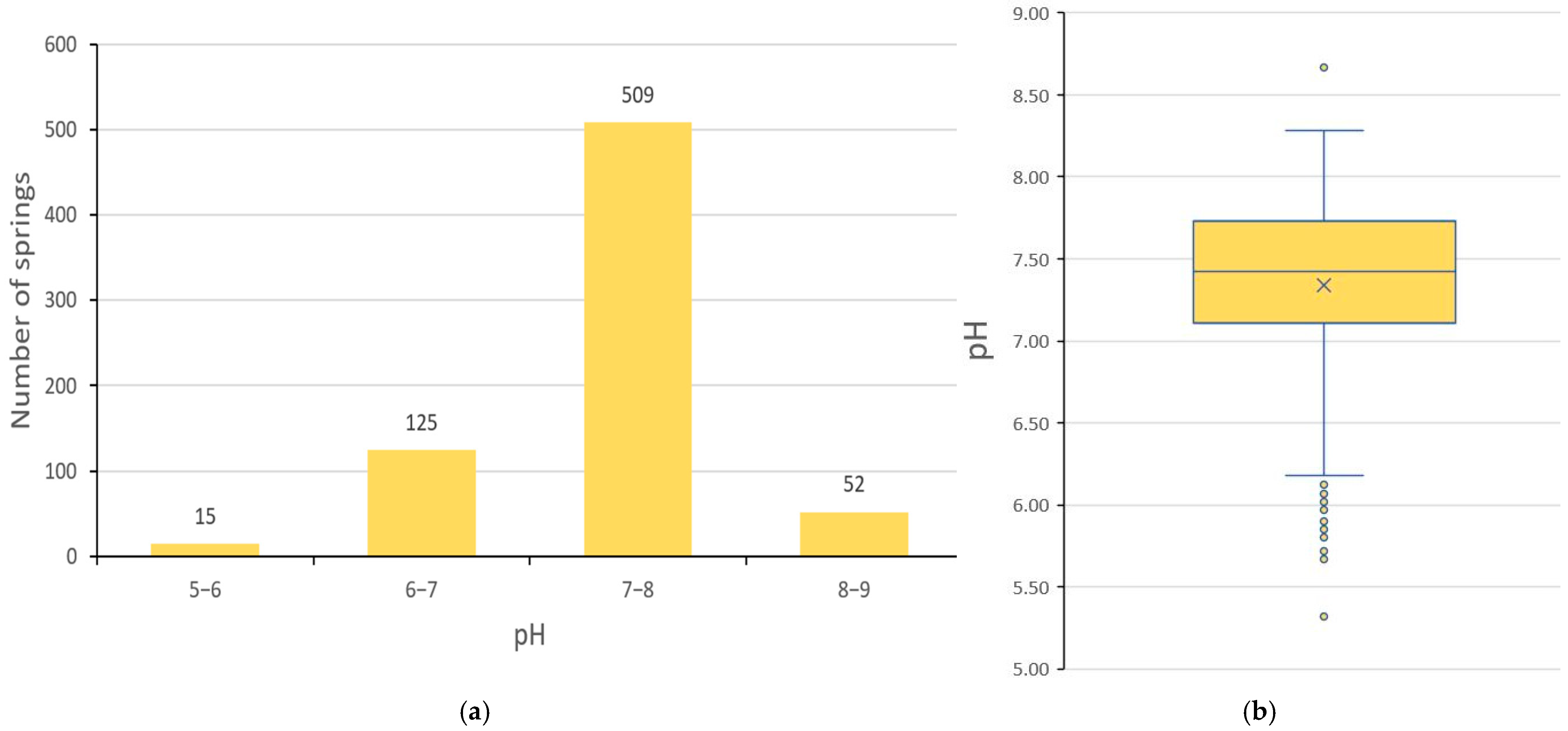
The measured pH values of the spring water also showed a certain diversity between the springs. The values range from a minimum of 5.32 to a maximum of 8.67. The mean of the measured pH values is 7.34, the median is 7.42. The standard deviation of the measured pH values is 0.52 [Table 1]. Almost 93% of the measured pH values of the spring water were between 6.5 and 8.5, which corresponds to the recommendations for drinking water of the World Health Organisation [41] and the regulations of the Ministry of Health and Social Welfare of the Republic of Croatia [42].
At the largest number of springs, 509 of them (72.61% of those measured), the measured pH values of water were between 7 and 8. At 140 springs (19.97%) pH values were lower than 7, 15 springs even lower than 6. At 52 springs (7.42%) pH values were higher than 8 (Figure 4a). It is important to note that the pH values measured below 6.2 were statistically marked as outliers, as was the highest measured pH value of 8.67 (Figure 4b).

3.3. EC of Spring Water

Electrical conductivity (EC) is a physical quantity that describes the ability of a substance (water) to conduct electric current. It is expressed in the unit of measurement S/m (Siemens per meter) or μS/cm (microsiemens per centimeter). Indirectly, the EC value can provide information about the quantity of dissolved matter in the water. The EC value is proportional to the amount of ions present in a solution and can therefore be used to estimate the amount of total dissolved solids (TDS), which are mostly inorganic [43].
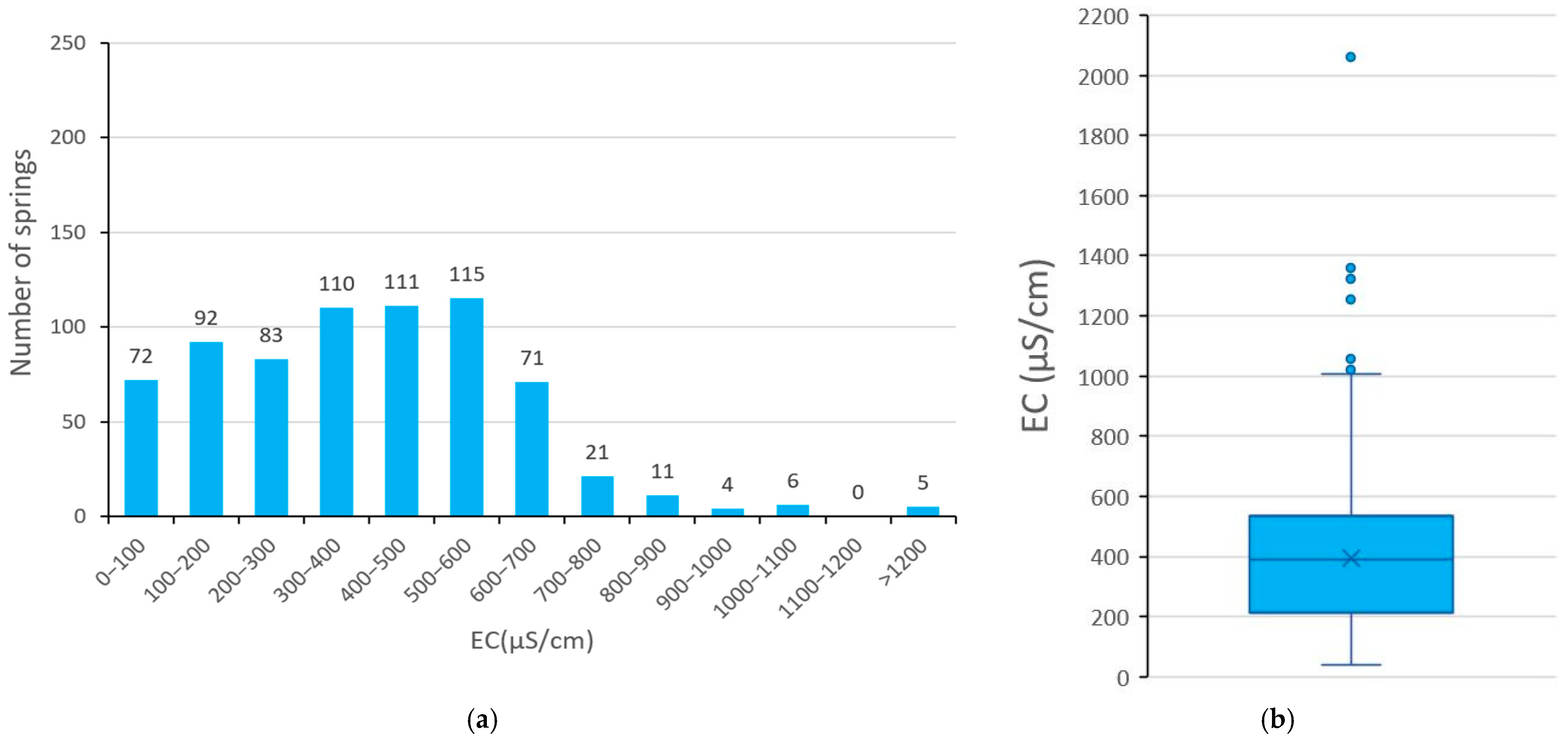
The measured EC values showed a relatively large diversity between springs. The lowest value measured was 41 μS/cm, and the highest was 2062 μS/cm. The mean value of all measurements was 394 μS/cm, and the median was 390 μS/cm. The standard deviation of the measured EC water values was 230.19 μS/cm [Table 1]. According to the field measurements, 96.29% of springs have EC values of less than 800 μS/cm (Figure 5), which makes them suitable for drinking, at least according to this parameter [42]. It should be noted that measured EC values above 1007 μS/cm were statistically marked as outliers.

3.4. Physicochemical Parameters and Lithology

The lithological environment of the spring and especially the lithological characteristics of the aquifer are one of the most important factors influencing the hydrochemical and physicochemical properties of spring water, together with the time of water retention in the ground [43]. The EC and pH values of the spring water were analysed in aspect to the available lithological data, i.e., the lithostratigraphic units on the geological map of Croatia [34,35]. The EC and pH data of spring water were grouped according to these units in order to determine potential differences [Table 2]. The data from 675 springs were analysed. As the scale of the maps, i.e., the lithostratigraphic units, is relatively rough (1:100,000), several springs at the boundary between the units were omitted, as were the springs that were the sole representatives of certain units. A total of 26 springs were not included in this part of the analysis. The differences in the total number of investigated springs within the lithostratigraphic units are mainly due to the difference in their area (Figure 1).
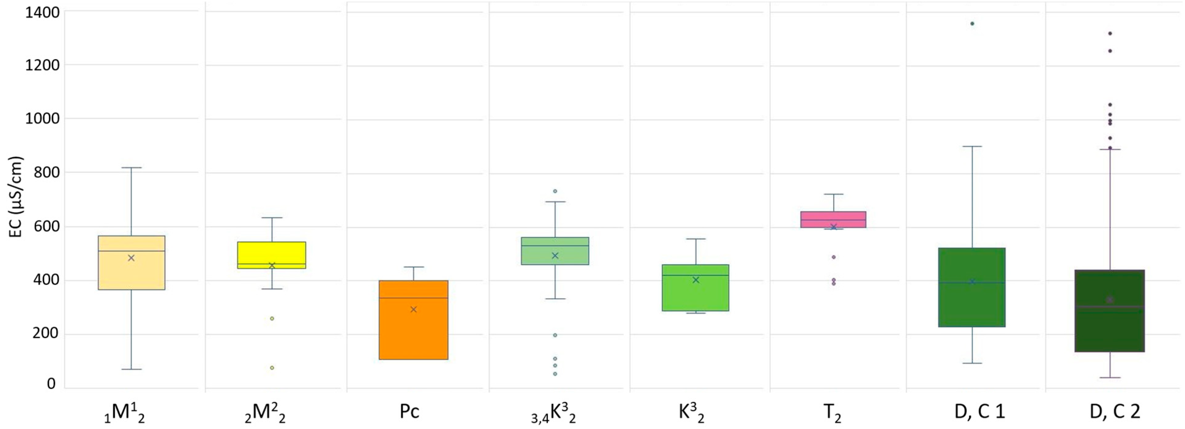
The results have shown differences in pH and EC values between springs in different lithostratigraphic units. More specifically, the measured parameters have shown different ranges within the units. The springs in the Devonian and Carboniferous age lithostratigraphic units (D, C 1 and D, C 2) have the highest absolute ranges of both pH and EC values (Table 2, Figure 6 and Figure 7). It is important to note that these lithostratigraphic units have the highest number of springs. The highest standard deviations of the EC values are in the same units (D, C 1 and D, C 2), while the highest standard deviations of the pH values of spring water are within the lithostratigraphic units D, C 1 and Miocene (1M12). The lowest absolute ranges and standard deviations of EC of spring waters are within lithostratigraphic units of Triassic (T2) age, but also Miocene (2M22), if we remove the outliers [Figure 6]. The lowest pH value ranges and standard deviation of pH of spring water are within those of Triassic (T2) and Paleogene (Pc) age (Table 2, Figure 6 and Figure 7). It is important to say that those lithostratigraphic units have a relatively low number of investigated springs. Highest average value of EC of spring water is within the Triassic carbonate rocks (T2), and highest average value of pH is measured at the springs on Cretaceous breccias, conglomerates and limestones (3,4K32). Lowest values of both EC and pH are measured at springs on the rocks of Paleogene age (Pc) [Table 2].
For further confirmation and insight into the diversity of the hydrochemical composition of spring water, a laboratory analysis of the ionic composition of selected springs was carried out. The selected springs on ortometamorphic rocks (D, C 2) were the neighbouring springs Mali and Mini, as well as Karlov izvor spring. The Kraljičin zdenac spring, situated on parametamorphic rocks (D, C 1) and the Jambrišakovo vrelo spring on Triassic carbonate rocks (T2) were also analysed (Figure 8). The water samples were taken twice, once in November 2022 and once in April 2023. The springs Mali, Mini and Kraljičin zdenac were monitored, and were chosen for the analysis because of their unusual EC values variations, which changed proportionally with discharge. The Karlov izvor spring was chosen because of its stable discharge and EC values to serve as a comparison to three before mentioned springs, since it is situated in the similar geological setting. The Jambrišakovo vrelo spring was chosen because of its specific geological setting, which is on Triassic carbonate rocks. The results should be representative for all of the other springs in this environment and should show the difference in hydrochemical properties from other chosen springs, which have different lithology.
According to the water analyses from both November 2022 and April 2023, the Jambrišakovo vrelo and Karlov izvor springs are of the calcium-bicarbonate type (Table 3 and Table 4, Figure 9). It is important to note that the Jambrišakovo vrelo spring has very high levels of bicarbonate ions and also higher levels of magnesium ions compared to the other springs. The springs Mali, Mini and Kraljičin zdenac belong to the same type, but have borderline values towards the mixed spring type, i.e., the calcium-chloride type [43,44]. Also noteworthy is the relatively high proportion of sodium and chloride ions in the Kraljičin zdenac, Mali and Mini springs. In the April analysis, the Mini spring showed characteristics of a mixed type between the calcium-chloride and calcium-carbonate type (Table 3 and Table 4, Figure 9).

4. Discussion

The measured physicochemical characteristics of spring water showed a relatively large diversity, especially in the case of EC. The reasons for this diversity may be different, both natural and anthropogenic. Compared to other studies in the Medvednica area, the ranges of measured values of physicochemical parameters are consistent. In a previous study in the southwestern part of the study area, the measured pH values of spring water ranged from 6.23 to 8.06 and the temperatures from 5.4 °C to 12.1 °C [19]. In a study in the northeastern part of Medvednica, which partly coincides with the study area, water temperatures between 9 °C and 14 °C were measured in 14 samples taken from captured springs, wells and reservoirs [20]. This coincides with the ranges of the measured values of the springs in this study. In the same study [20], pH and EC values were also measured. The pH values of the same samples showed a relatively small variation from 7.23 to 7.8, while the EC values were between 134 μS/cm and 507 μS/cm, which also falls within the range of the values measured in this study.

4.1. Factors Influencing Spring Water Temperature

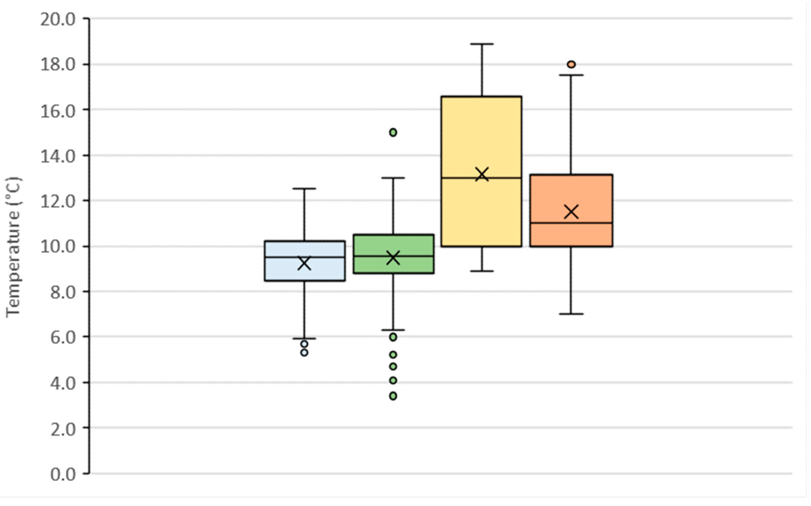
The results have shown surprisingly high variations in spring water temperatures in the study area. Even though most springs have water temperature that corresponds to the mean annual temperatures, lower and higher temperatures are also common (Figure 3, Table 1). The first assumption for the temperature differences was linked to the altitude of the springs. It was assumed that springs at lower elevations would have higher temperatures than those at higher elevations, but the correlation analysis showed that there was almost no relationship between these variables (r = 0.065). The reasons for the temperature differences were of different nature: hydrogeological, hydro-logical and methodological. Most of the investigated springs have small and shallow aquifers with short groundwater retention time. They also have relatively low discharges with low flow velocity. All this makes the groundwater temperature and the temperature of the water at the point of emergence to the surface more susceptible to external/environmental influences. In this case, direct sunlight, shading, air and soil temperature influence the measured spring water temperatures. Thus, relatively higher water temperatures were measured in the springs investigated in the warmer months of the year and very low temperatures in those investigated in winter (Table 5; Figure 10). The lowest temperatures were measured in (early) spring, during snowmelt and in the winter months. The highest in the summer months, although very high temperatures were measured in both (late) spring and autumn (Table 5; Figure 10). The largest absolute range was recorded in the spring months, while the largest range between the first and third quartiles, the largest standard deviation and the largest coefficient of variation were recorded in the summer months (Table 5; Figure 10). This can be explained by the difference in temperature between low discharge seepage springs and relatively more water abundant springs with deep aquifers and more constant temperatures.
Additional arguments in favour of these claims are provided by the ranges of measured spring water temperature values within different categories of spring discharges. It can be seen that the absolute amplitude decreases with increasing discharge, as does the range of temperature values between the first and third quartiles of the measured temperatures (Table 6, Figure 11). The standard deviation and the coefficient of variation show the same result, with the exception that for springs of discharge category VI (0.1–1 L/s) where the value of the standard deviation and the coefficient of variation is lower than that for springs of category V (>1 L/s) (Table 6, Figure 11). This distribution of temperature variability by discharge categories is presumably a consequence of the aforementioned susceptibility of springs with low discharge to temperature changes due to external influences and the shorter retention time of water in the underground, especially in the case of low temperatures.
These findings also highlight that the environmental conditions in the vicinity of the springs influence their water temperature. In this context, direct sunlight and shading in the forest environment can be important factors influencing the temperature of spring water and thus its quality [45,46]. Therefore, forest management practices, including tree cutting in the study area, could potentially have a negative impact on the ecological status of these springs.

4.2. Factors Influencing EC and pH of Spring Water

The analysis of the measured pH and EC values in relation to the lithostratigraphic units showed that the smallest variations in EC values occur in the areas of the Middle Triassic dolomites (T2) and the Miocene lithothamnium limestones (2M22) (Figure 6, Table 2). These results can be explained by the carbonate lithological composition of these lithostratigraphic units. Triassic dolomites and Miocene lithothamnium limestones in the southeastern part of the study area are relatively well karstified [21,35,39,47]. This indicates that they can form significant aquifers in which water is retained over a longer period of time, reducing EC variability [48,49]. This is also evidenced by the relatively high EC values, which are the result of longer retention of water in the underground made of well-soluble rocks [48,50]. This statement may also be supported by the minimum pH values measured in that area, which are higher than 7.10 and significantly higher than all other minimum values in the area of other lithostratigraphic units (Figure 7).
A large variety of measured EC and pH values of spring water was found in the areas of the lithostratigraphic units of the Devonian and Carboniferous parametamorphites and orthometamorphites (D, C 1 and D, C 2) and in the area of the Miocene conglomerates, gravels and sands (1M12). The areas of parametamorphic and orthometamorphic rocks of the Medvednica mountain usually do not have hydrogeological properties favorable for the formation of large and deep aquifers [23,51]. Consequently, the pH and EC values of spring water should be relatively low under natural conditions, in the context of this research. In particular, the pH and EC values of precipitation are generally very low, which, in combination with a short residence time in the underground or along the seepage pathways, should lead to relatively low values of the analysed parameters. This is the case in some springs, but there are also a very large number of springs with high EC and pH values. Therefore, it should be assumed that the physicochemical properties of spring water are also influenced by other factors, in addition to the lithological conditions and the retention time of the water. Most springs with very high EC values are located near or downstream of asphalt roads (Figure 8). All of the roads are regularly treated with de-icing agents (salt) during the colder part of the year. These are mainly salts of light metals: Sodium chloride NaCl, calcium chloride CaCl2, magnesium chloride MgCl2 and some other chemical compounds. Sodium chloride is mainly used (97%) [52,53]. Previous research [52,53,54] has determined the effects of de-icing agents on the soil and vegetation in the vicinity of the road, where higher concentrations of salts were found. It is therefore assumed that this salt is dissolved by rainfall and snowmelt and then reaches the springs or their aquifers via shallow underground channels. Three of the before mentioned monitored springs were selected for laboratory analysis due to the fluctuations and unusually high EC values: The Mini spring, the Mali spring and the Kraljičin zdenac spring. What they have in common is that they are located directly below the asphalt road. Laboratory analysis of the ionic composition of the springs’ water revealed elevated levels of sodium and chloride ions in both series of samples (Table 3 and Table 4). The presence of salts, i.e., sodium and chloride ions, significantly increases the EC of water. Similar findings have been found in other research around the world [55,56,57,58]. Road salinisation has a strong influence on the ecological status of groundwater and freshwater ecosystems [56,57,59], as well as on the quality of drinking water [56,57,58,59], so it is vital to address this issue.
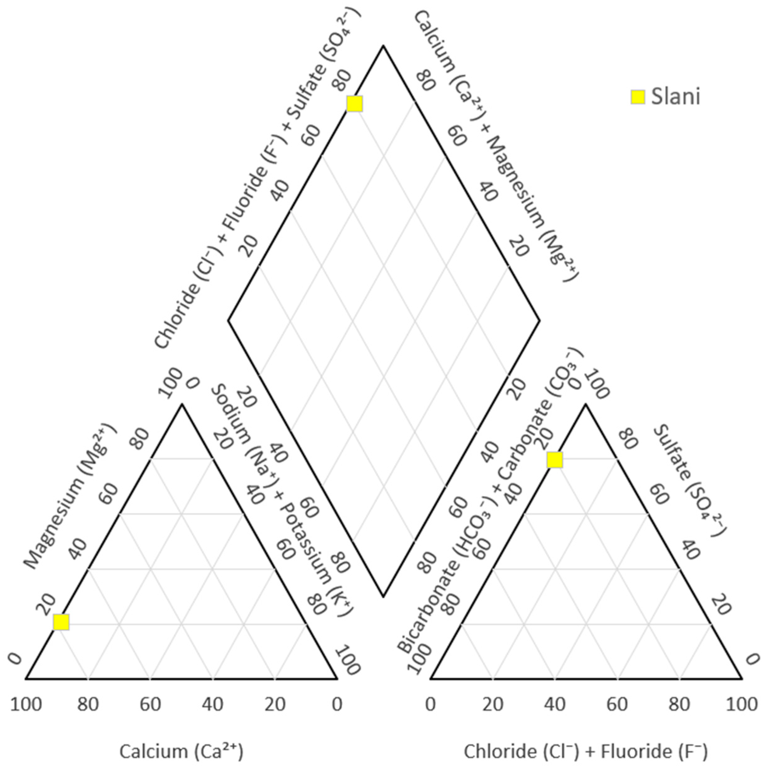
It is important to highlight one spring that is characterised by its exceptionally high electrical conductivity (EC) value. For the purposes of this research it has been labelled as the Slani (salty) spring. The EC value measured at the Slani spring was 2062 μS/cm, which is by far the highest value measured in this research. Laboratory analyses revealed an increased concentration of calcium and sulphate ions (Table 7, Figure 12), indicating the presence of gypsum, a highly water-soluble evaporite rock. Several gypsum deposits have been recorded on Medvednica mountain previously [60]. Two gypsum deposits were found within a radius of about 700 m from the aforementioned spring during earlier research [60,61], which supports the claim of the existence of gypsum deposits in the spring aquifer. These findings lead to the conclusion that it is a natural mineral spring of calcium sulfate type (Figure 12).
As for pH values, their variability can result from many environmental factors in addition to water retention time, lithological composition and rock solubility. These include biological processes related to microorganisms in the water, the vegetation cover in the vicinity of the spring, atmospheric influences (such as pollutants or direct sunlight) and various anthropogenic influences (in this area: roads, restaurants, tree cutting, etc.) [50]. The main reasons for the observed variability in pH could not be determined in this research, and additional data and investigation would be required to further clarify this question. Nevertheless, certain differences between pH ranges of spring water of different lithological units were determined, most notably being the small pH variations in springs on Miocene and Triassic carbonate rocks (Figure 7). Very low values were usually measured at less water abundant springs, one or two days after precipitation events or during snowmelt.

5. Conclusions

This study represents the first systematic inventory of springs on the southern slopes of the Nature park Medvednica. The results have shown a considerable diversity in terms of water temperature, pH and electrical conductivity across the 701 springs measured. This diversity is the result of complex interactions of natural factors such as (hydro)geology, hydrological conditions, seasonal meteorological influences and anthropogenic impacts, most notably winter road treatment.
The results obtained in this research illustrate both the vulnerability and the importance of springs. Similar physicochemical diversity observed in this study has been reported in other mountainous regions with complex geology and different hydrogeological properties. For example, in areas such as the Alps [62], the Apennines [63] and the Polish mountains and uplands [15,64,65], studies have shown the role of lithology in determining the physicochemical properties of spring water, but also that even moderate human activities can alter them.
This study also emphasises that even springs located in protected areas may suffer from various anthropogenic influences, such as those observed on Medvednica mountain. The springs of the Nature park Medvednica are to be included in protection zone 1B, an area with strict protection measures, but that can still be visited by people [31]. However, the inventory of springs remains incomplete, as only the southern half of the nature park has been surveyed so far. Without a proper inventory with basic data, it is difficult to implement effective measures to manage and protect the springs.
The springs in the Medvednica mountain have significant (geo)ecological and hydrological value. They are also important for people, as many springs are used daily by hikers and visitors as refreshment points. Some springs are connected to the local water supply systems and others have a historical or cultural value.
Due to all the reasons described above, it is important to continue this type of research and extend it to other parts of the nature park in order to complete the database and gain further knowledge that can support spring management and environmental protection in the area. Such a database can serve as a basis for further interdisciplinary research in the Medvednica mountain and could also provide a methodological framework for studying springs in other mountainous regions of Croatia.

Author Contributions

Conceptualization, I.M. and I.Č.; methodology, I.M. and I.Č.; software, I.M.; validation, I.M. and I.Č.; formal analysis, I.M.; investigation, I.M. and I.Č.; resources, I.M. and I.Č.; data curation, I.M.; writing—original draft preparation, I.M.; writing—review and editing, I.Č.; visualization, I.M.; supervision, I.Č.; project administration, I.M. and I.Č.; funding acquisition, I.M. and I.Č. All authors have read and agreed to the published version of the manuscript.

Funding

This research received no external funding.

Institutional Review Board Statement

Not applicable.

Informed Consent Statement

Not applicable.

Data Availability Statement

We agree that the results and all of the shown data used in the article are fully available within the manuscript and open access. However, the raw (spring) database used in this research is quite large and complex and therefore it is not suitable for submission or addition in a form of appendix. Nevertheless, we would invite anyone who is interested in the raw database to contact us so we can provide the data of interest to them. I posted a part of the data used within the excel sheet in the submission process in the step where the minimal data was required.

Acknowledgments

We would like to thank everyone who helped with the fieldwork and collection of the data.

Conflicts of Interest

The authors declare no conflicts of interest.

References

  1. Stevens, L.E. Chapter 1: Springs of the World. In Springs of the World: Distribution, Ecology, and Conservation Status; Monograph 1; Stevens, L.E., Ed.; Spring Stewardship Institute: Flagstaff, AZ, USA, 2023; 198p. [Google Scholar]
  2. Martinić, I. An overview of classifications and modern research of springs in the world and in Croatia. Croat. Geogr. Bull. 2022, 84, 31–68. [Google Scholar] [CrossRef]
  3. Cantonati, M.; Fensham, R.J.; Stevens, L.E.; Gerecke, R.; Glazier, D.S.; Goldscheider, N.; Knight, R.L.; Richardson, J.S.; Springer, A.E.; Töckner, K. An urgent plea for global spring protection. Conserv. Biol. 2020, 35, 378–382. [Google Scholar] [CrossRef]
  4. Springer, A.E.; Stevens, L.E.; Ledbetter, J.D.; Schaller, E.M.; Gill, K.; Rood, S.B. Ecohydrology and stewardship of Alberta springs ecosystems. Ecohydrology 2015, 8, 896–910. [Google Scholar] [CrossRef]
  5. Cantonati, M.; Stevens, L.E.; Sagadelli, S.; Springer, A.E.; Goldscheider, N.; Celico, F.; Filippini, M.; Ogata, K.; Gargini, A. Ecohydrogeology: The inderdisciplinary convergence needed to improve the study and stewardship of springs and other groundwater-dependent habitats, biota and ecosystems. Ecol. Indic. 2020, 110, 105803. [Google Scholar] [CrossRef]
  6. Culver, D.C.; Pipan, T.; Gottstein, S. Hypotelminorheic—A Unique Freshwater Habitat. Subterr. Biol. 2006, 4, 1–8. [Google Scholar]
  7. Pozojević, I.; Brigić, A.; Gottstein, S. Water mite (Acari: Hydrachnidia) diversity and distribution in undisturbed Dinaric karst springs. Exp. Appl. Acarol. 2018, 76, 123–138. [Google Scholar] [CrossRef] [PubMed]
  8. Pozojević, I.; Pešić, V.; Gottstein, S. Two water mite species (Acari: Hydrachnidia) from karst springs new for the fauna of Croatia with notes on distribution and environmental preferences. Nat. Croat. 2019, 28, 417–424. [Google Scholar] [CrossRef]
  9. Pozojević, I.; Pešić, V.; Goldschmidt, T.; Gottstein, S. Crenal Habitats: Sources of Water Mite (Acari: Hydrachnidia) Diversity. Diversity 2020, 12, 316. [Google Scholar] [CrossRef]
  10. Martinić, I. Hydrological and Geomorphological Characteristics of Springs on the South Side of the Medvednica Nature Park. Ph.D. Dissertation, University of Zagreb, Zagreb, Croatia, 15 October 2024. [Google Scholar]
  11. Mostowik, K.; Górnik, M.; Jaśkowiec, B.; Maciejczyk, K.; Murawska, M.; Płaczkowska, E.; Rzonca, B.; Siwek, J. High discharge springs in the Outer Flysch Carpathians on the example of the High Bieszczady Mountains (Poland). Carpathian J. Earth Environ. Sci. 2016, 11, 395–404. [Google Scholar]
  12. Mostowik, K.; Krzyczman, D.; Płaczkowska, E.; Rzonca, B.; Siwek, J.; Wacławczyk, P. Spring Recharge and Groundwater Flow Patterns in a Flysch Aquifer in the Połonina Wetlińska Massif, Carpathian Mountains. J. Mt. Sci. 2021, 18, 819–833. [Google Scholar] [CrossRef]
  13. Cervi, F.; Marcaccio, M.; Petronici, F.; Borgatti, L. Hydrogeological Characterization of Peculiar Apenninic Springs. Proc. Int. Assoc. Hydrol. Sci. 2014, 364, 333–338. [Google Scholar] [CrossRef]
  14. Buczyński, S.; Rzonca, B. Influence of geologic structure on the presence, discharge and physical and chemical properties of springs in the Muszynka catchment (Carpathian flysch). Episodes 2018, 48, 89–96. [Google Scholar] [CrossRef]
  15. Siwek, J.; Chełmicki, W. Geology and Land-Use-Related Pattern of Spring Water Quality: Case Study from the Catchments of the Małopolska Upland (S. Poland). Geol. Acta 2004, 2, 167–174. [Google Scholar]
  16. Andreo, B.; Liñán, C.; Carrasco, F.; Jiménez-de-Cisneros, C.; Caballero, E.; Mudry, J. Groundwater Temperature and Electrical Conductivity as Tools to Characterize Flow Patterns in Carbonate Aquifers: The Sierra de las Nieves Karst Aquifer, Southern Spain. Hydrogeol. J. 2008, 16, 641–651. [Google Scholar] [CrossRef]
  17. Khadka, K.; Rijal, M.L.; Gyawali, R. Factors Controlling the Variation in Physicochemical Parameters of Springs in the Melamchi Area, Nepal. J. Nepal Geol. Soc. 2023, 66, 1–12. [Google Scholar] [CrossRef]
  18. Medler, C.J.; Eldridge, W.G. Spring Types and Contributing Aquifers from Water-Chemistry and Multivariate Statistical Analyses for Seeps and Springs in Theodore Roosevelt National Park, North Dakota, 2018; Scientific Investigations Report 2020–5121; U.S. Geological Survey: Reston, VA, USA, 2021; 48p. [CrossRef]
  19. Brletić, F. Hydrological Objects on Southwestern Hills of the Medvednica Nature Park. Paper for Rector’s reward, University of Zagreb, Zagreb, Croatia, 2017. (In Croatian). [Google Scholar]
  20. Lovrić, F.; Kapelj, S.; Loborec, J. Assessment of drinking water supplies based on the hydrogeological features in the north-east part of Prigorje. Environ. Eng. 2017, 4, 25–39. (In Croatian) [Google Scholar]
  21. Šikić, K. Geological Guide to Medvednica; Institut za geološka istraživanja: Zagreb, Croatia, 1995. (In Croatian) [Google Scholar]
  22. Brkić, Ž.; Čakarun, I. Basic Hydrogeological Map of Croatia 1:100,000, Sheet Zagreb; Institut za geološka istraživanja, Zavod za hidrogeologiju i inženjersku geologiju: Zagreb, Croatia, 1998. (In Croatian) [Google Scholar]
  23. Brkić, Ž.; Čakarun, I. Basic Hydrogeological Map of Croatia 1:100,000, Sheet Zagreb—Interpreter; Institut za geološka istraživanja, Zavod za hidrogeologiju i inženjersku geologiju: Zagreb, Croatia, 1998. (In Croatian) [Google Scholar]
  24. Slišković, I.; Šarin, A. Basic Hydrogeological Map of Croatia 1:100,000, Sheet Ivanić Grad; Institut za geološka istraživanja, Zavod za hidrogeologiju i inženjersku geologiju: Zagreb, Croatia, 1999. (In Croatian) [Google Scholar]
  25. Slišković, I.; Šarin, A. Basic Hydrogeological Map of Croatia 1:100,000, Sheet Ivanić Grad—Interpreter; Institut za geološka istraživanja, Zavod za hidrogeologiju i inženjersku geologiju: Zagreb, Croatia, 1999. (In Croatian) [Google Scholar]
  26. Martinić, I.; Vinković, K.; Płaczkowska, E. Geomorphological and Hydrogeographical Research of Mali and Veliki Potok on Medvednica Mountain. In Book of Abstracts: Proceedings of the 7th Croatian Geographical Congress, Čakovec, Croatia, 9–10 October 2019; Croatian Geographical Society: Zagreb, Croatia, 2019; pp. 57–60. [Google Scholar]
  27. Dekić, S.; Hrenović, J. Bacteriological Analysis of Spring Water in the Vicinity of Popular Visitor Spots in the Nature Park Medvednica. Hrvatske Vode 2017, 25, 13–16. [Google Scholar]
  28. Erdelez, A. Environmental Protection Report for the Assessment of the Need for Environmental Impact Evaluation: Construction of the Krumpirište Reservoir for Snowmaking on the Sljeme Ski Slopes; Fidon d.o.o.: Zagreb, Croatia, 2019; 171p. (In Croatian) [Google Scholar]
  29. Vujnović, T. Springs of the Žumberak–Samoborsko Gorje Nature Park. Nat. Croat. 2011, 20, 19–34. [Google Scholar]
  30. Roglić, J. Geomorphological Topics: Collected Works of Josip Roglić, Book II; Maras, M., Ed.; Geographic Society: Split, Croatia; Croatian Geographical Society: Zadar, Croatia; Faculty of Science, University of Zagreb: Zagreb, Croatia; University of Zadar: Zadar, Croatia; Meridijani: Samobor, Croatia, 2005; p. 558. (In Croatian) [Google Scholar]
  31. Farkaš-Topolnik, N. (Ed.) Management Plan of the Medvednica Nature Park; JU Park prirode Medvednica: Zagreb, Croatia, 2009; p. 78. (In Croatian) [Google Scholar]
  32. Žugaj, R. Big Waters of Small Catchments; Zorić, I., Ed.; Rudarsko-geološko-naftni fakultet, Sveučilište u Zagrebu: Zagreb, Croatia; Hrvatska komora arhitekata i inženjera u graditeljstvu: Zagreb, Croatia, 2010; p. 77. (In Croatian) [Google Scholar]
  33. Belak, M.; Slovenec, D.; Kolar Jurkovšek, T.; Garašić, V.; Pécskay, Z.; Tibljaš, D.; Mišur, I. Low-Grade Metamorphic Rocks of the Tethys Subduction–Collision Zone in the Medvednica Mt. (NW Croatia). Geol. Carpath. 2022, 73, 207–229. [Google Scholar] [CrossRef]
  34. Šikić, K.; Basch, O.; Šimunić, A. Basic Geological Map of the SFRY 1:100,000, Sheet Zagreb L33–80; Institut za geološka istraživanja: Zagreb, Croatia; Savezni geološki zavod: Belgrade, Serbia, 1977. (In Croatian) [Google Scholar]
  35. Šikić, K.; Basch, O.; Šimunić, A. Basic Geological Map of the SFRY 1:100,000, Interpreter for Sheet Zagreb L33–80; Institut za geološka istraživanja: Zagreb, Croatia; Savezni geološki zavod: Belgrade, Serbia, 1979. (In Croatian) [Google Scholar]
  36. National Geographic World Map. National Geographic, Esri, Garmin, HERE, UNEP-WCMC, USGS, NASA, ESA, METI, NRCAN, GEBCO, NOAA, Increment P Corp. Available online: https://www.arcgis.com/home/item.html?id=b9b1b422198944fbbd5250b3241691b6 (accessed on 4 July 2025).
  37. Kottek, K.; Grieser, J.; Beck, C.; Rudolf, B.; Rubel, F. World Map of the Köppen–Geiger Climate Classification Updated. Meteorol. Z. 2006, 15, 259–263. [Google Scholar] [CrossRef]
  38. Meinzer, O.E. Outline of Ground-Water Hydrology; US Government Printing Office: Washington, DC, USA, 1923; 71p.
  39. Martinić, I.; Čanjevac, I. Distribution and Characteristics of Springs in Two Neighboring Areas of Different Morphogenic Relief Type—Example of SW Medvednica Mountain (Central Croatia). Water 2024, 16, 994. [Google Scholar] [CrossRef]
  40. Croatian Meteorological and Hydrological Service. Temperature and Precipitation Data; Data set sent to the authors for the research purposes; Croatian Meteorological and Hydrological Service: Zagreb, Croatia, 2024. [Google Scholar]
  41. World Health Organization (WHO). pH in Drinking-Water: Revised Background Document for Development of WHO Guidelines for Drinking-Water Quality; WHO: Geneva, Switzerland, 2007; Available online: https://cdn.who.int/media/docs/default-source/wash-documents/wash-chemicals/ph.pdf (accessed on 23 June 2025).
  42. Croatian Ministry of Health and Social Welfare. Regulation on the Health Safety of Drinking Water; NN 47/2008; Narodne novine: Zagreb, Croatia, 17 April 2008; Available online: https://narodne-novine.nn.hr/clanci/sluzbeni/2008_04_47_1593.html (accessed on 23 June 2025).
  43. Clark, I. Groundwater Geochemistry and Isotopes; CRC Press: Boca Raton, FL, USA, 2015. [Google Scholar] [CrossRef]
  44. Piper, A.M. A Graphic Procedure in the Geochemical Interpretation of Water-Analyses. Trans. Am. Geophys. Union 1944, 25, 914–928. [Google Scholar]
  45. Brown, G.W.; Krygier, J.T. Effects of Clear-Cutting on Stream Temperature. Water Resour. Res. 1970, 6, 1133–1139. [Google Scholar] [CrossRef]
  46. Johnson, S.L.; Jones, J.A. Stream Temperature Responses to Forest Harvest and Debris Flows in Western Cascades, Oregon. Can. J. Fish. Aquat. Sci. 2000, 57, 30–39. [Google Scholar] [CrossRef]
  47. Buzjak, N. Geotouristic potential of caves–example of Veternica Cave (Medvednica Nature Park, Croatia). In Proceedings of the 12th EuroSpeleo Forum, Ebensee, Austria, 23–26 August 2018; Mattes, J., Christian, E., Plan, L., Eds.; Verein für Höhlenkunde Ebensee: Neukirchen, Austria, 2018; pp. 38–41. [Google Scholar]
  48. Ford, D.C.; Williams, P. Karst Hydrogeology and Geomorphology; John Wiley & Sons: Hoboken, NJ, USA, 2007. [Google Scholar]
  49. Hartmann, A.; Goldscheider, N.; Wagener, T.; Lange, J.; Weiler, M. Karst Water Resources in a Changing World: Review of Hydrological Modeling Approaches. Rev. Geophys. 2014, 52, 218–242. [Google Scholar] [CrossRef]
  50. Hem, J.D. Study and Interpretation of the Chemical Characteristics of Natural Water; U.S. Geological Survey Water-Supply Paper 2254; U.S. Government Printing Office: Washington, DC, USA, 1985.
  51. Kresic, N. Hydrogeology and Groundwater Modeling; CRC Press: Boca Raton, FL, USA, 2007. [Google Scholar] [CrossRef]
  52. Šimunjak, Z.Z. Effects of Winter Road Maintenance on Bridges and Road Structures; Croatian Road Worker, Croatian Economic Interest Group of Road Maintenance Companies: Zagreb, Croatia, 2006; pp. 93–98. (In Croatian) [Google Scholar]
  53. Bulić, M. Chemical Characteristics of Soil in Medvednica Nature Park Regarding the Application of Road Salt in Winter Maintenance. Bachelor’s Thesis, Faculty of Agriculture, University of Zagreb, Zagreb, Croatia, 2016. (In Croatian). [Google Scholar]
  54. Jurišić, A.; Bogunović, I.; Vugrek Petljak, K.; Bulić, M.; Kisić, I. Influence of Salt Application in Winter Road Maintenance on Chemical Soil Properties in Medvednica Nature Park. In Vision and Challenges of Protected Area Management in the Republic of Croatia: Active Protection and Sustainable Management in Krka National Park; Marguš, D., Ed.; Public Institution “Krka” National Park: Šibenik, Croatia, 2015; p. 110. [Google Scholar]
  55. Foos, A. Spatial Distribution of Road Salt Contamination of Natural Springs and Seeps, Cuyahoga Falls, Ohio, USA. Environ. Geol. 2003, 44, 920–931. [Google Scholar] [CrossRef]
  56. Williams, D.D.; Williams, N.E.; Cao, Y. Road Salt Contamination of Groundwater in a Major Metropolitan Area and Development of a Biological Index to Monitor Its Impact. Water Res. 1999, 33, 2569–2577. [Google Scholar] [CrossRef]
  57. Tiwari, A.; Rachlin, J.W. A Review of Road Salt Ecological Impacts. Northeast. Nat. 2018, 25, 123–142. [Google Scholar] [CrossRef]
  58. Jandová, V.; Bucková, M.; Hegrová, J.; Dostál, I.; Huzlík, J.; Effenberger, K.; Ličbinský, R. The Relationship among Precipitation, Application of Salt in Winter Road Maintenance and the Quality of Waterways and Soil around Motorway. Water 2020, 12, 2206. [Google Scholar] [CrossRef]
  59. Dugan, H.A.; Arnott, S.E. The Ecosystem Implications of Road Salt as a Pollutant of Freshwaters. WIREs Water 2023, 10, e1629. [Google Scholar] [CrossRef]
  60. Zagorščak, D. Gypsum from Two Localities in Medvednica (Croatia). Geol. Vjesn. 1988, 41, 75–80. (In Croatian) [Google Scholar]
  61. Jamičić, D.; Slovenec, D. Tectonic Setting of Recently Found Gypsum Deposits of Mt. Medvednica (Northwestern Croatia). Nat. Croat. 2002, 11, 27–51. [Google Scholar]
  62. Cantonati, M.; Gerecke, R.; Bertuzzi, E. Springs of the Alps—Sensitive Ecosystems to Environmental Change: From Biodiversity Assessments to Long-Term Studies. Hydrobiologia 2006, 562, 59–96. [Google Scholar] [CrossRef]
  63. Rufino, F.; Busico, G.; Cuoco, E.; De Santis, M.; Tedesco, D. Hydrogeochemical Investigation of the Apennine Carbonate Springs by Factor Analysis. In Recent Advances in Environmental Science from the Euro-Mediterranean and Surrounding Regions, 2nd ed.; Ksibi, M., Ghorbal, A., Chakraborty, S., Chaminé, H.I., Barbieri, M., Guerriero, G., Hentati, O., Negm, A., Lehmann, A., Römbke, J., et al., Eds.; Springer: Cham, Switzerland, 2021. [Google Scholar] [CrossRef]
  64. Siepak, M.; Lewandowska, A.; Sojka, M. Variability in the Chemical Composition of Spring Waters in the Postomia River Catchment (Northwest Poland). Water 2023, 15, 157. [Google Scholar] [CrossRef]
  65. Szczucińska, A. Spring water chemistry in a formerly glaciated area of western Poland the contribution of natural and anthropogenic factors. Environ. Earth Sci. 2016, 75, 712. [Google Scholar] [CrossRef]
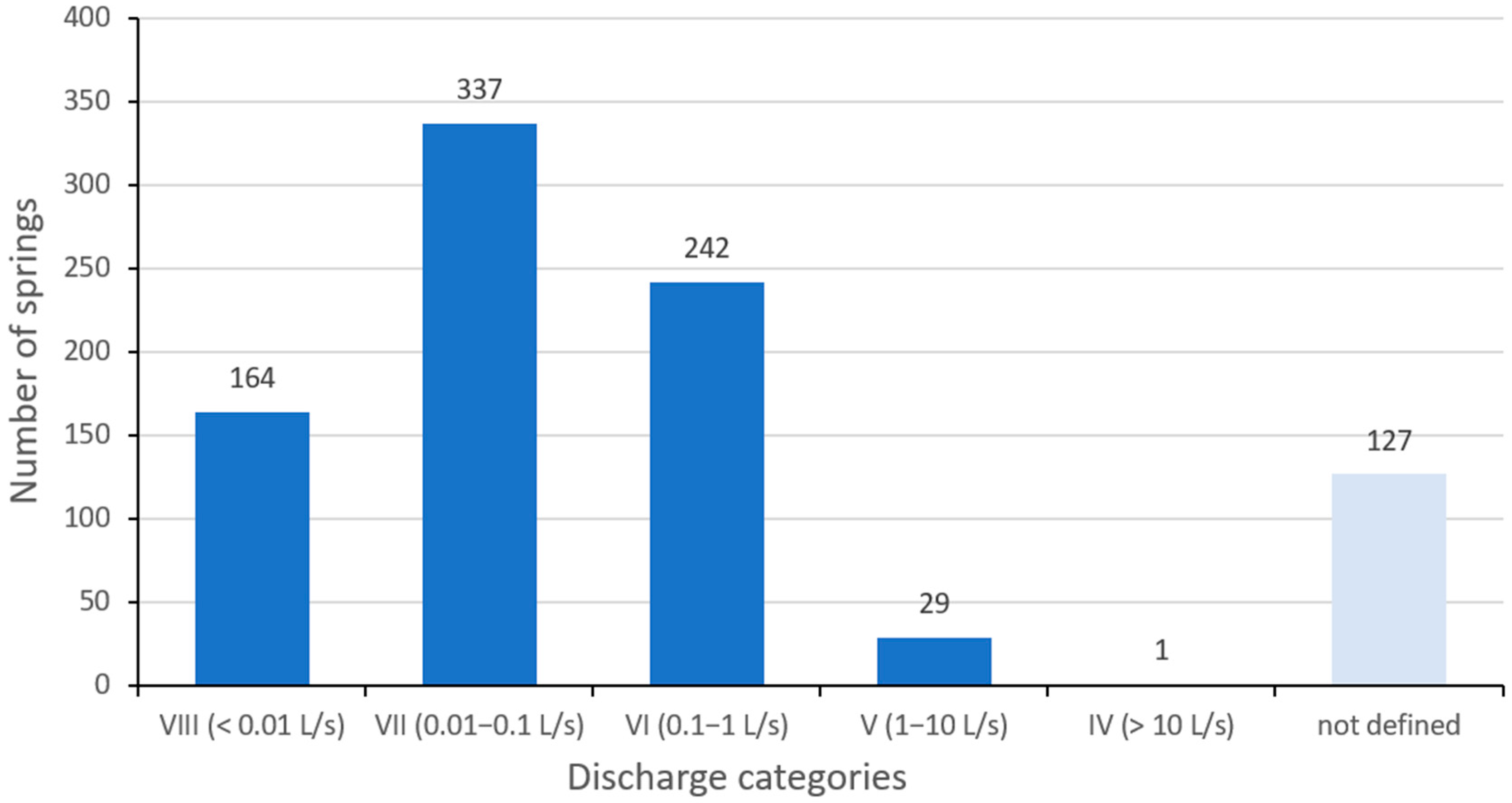
Figure 2. Number of springs by discharge categories.
Limnolrev 25 00036 g002
Figure 3. Number of springs by measured water temperature ranges (a) and total range of measured temperature values (b).
Limnolrev 25 00036 g003
Figure 4. Number of springs by measured pH value ranges (a) and total range of measured pH values (b).
Limnolrev 25 00036 g004
Figure 5. Number of springs by measured EC value ranges (a) and total range of measured EC values (b).
Limnolrev 25 00036 g005
Figure 6. Ranges of measured EC values of spring water in different lithostratigraphic units.
Limnolrev 25 00036 g006
Figure 7. Ranges of measured pH values of spring water in different lithostratigraphic units.
Limnolrev 25 00036 g007
Figure 8. Spatial distribution of measured EC values of spring water and the position of springs analysed in the laboratory. Background made after data from available geological maps [21,34].
Limnolrev 25 00036 g008
Figure 9. Piper diagram of ion composition of chosen springs in November 2022 (a) and April 2023 (b).
Limnolrev 25 00036 g009
Figure 10. Ranges of measured spring water temperatures in winter (blue), spring (green), summer (yellow) and autumn (orange).
Limnolrev 25 00036 g010
Figure 11. Ranges of measured spring water temperatures within discharge categories.
Limnolrev 25 00036 g011
Figure 12. Piper diagram of ion composition of the Slani spring from July 2023.
Limnolrev 25 00036 g012
Table 1. Descriptive statistics of measured physicochemical parameters of spring water.
MinMaxAverageMedianStandard Deviation
Temperature (°C)3.418.910.23102.36
EC (μS/cm)412062394390230.19
pH5.328.677.347.420.52
Table 2. Descriptive statistics of measured physicochemical parameters of spring water in different lithological units.
Age
(Map Code)
Rock TypeN **EC
Min (μS/cm)
EC
Max (μS/cm)
EC
Avg ** (μS/cm)
EC
Range
(μS/cm)
EC
σ ***
(μS/cm)
pH
Min
pH MaxpH Avg *pH
Range
pH
σ ***
Miocene (1M12)Conglomerates, gravels, sands3971817485746175.96.018.077.232.060.49
Miocene (2M22)Limestones, marls, sandstones3178635458557132.26.118.077.451.960.44
Paleogene (Pc)Conglomerates, sandstones, marls, and limestones7107452294345127.96.657.226.960-570.24
Cretaceous
(3,4K32)
Breccias, conglomerates, limestones95537444936911505.988.267.522.280.46
Cretaceous (K32)Conglomerates, limestones, marls1128155740527683.36.587.997.31.410.44
Triassic
(T2)
Dolomites, subordinately limestones2239072360233394.77.168.17.480.940.26
Devonian, Carboniferous
(D, C 2)
Orthometamorphic rocks–schists, gabbros, diabases1209313583971265210.46.278.677.492.40.4
Devonian, Carboniferous
(D, C 1)
Parametamorphic rocks–conglomerates, greywackes, siltstones, limestones, dolomites3504113223311281239.55.328.287.232.960.58
* Avg—average value of the parameter measured. ** N—the number of analyzed springs within the lithostratigraphic unit. *** σ—standard deviation of the parameter measured.
Table 3. Ionic composition of spring water of chosen springs in November 2022.
Spring Name
(Lithostratigraphic Unit)
F (mg/L)Cl (mg/L)NO3 (mg/L)SO42− (mg/L)HCO3
(mg/L)
Li+ (mg/L)Na+ (mg/L)K+ (mg/L)Mg2+ (mg/L)Ca2+
(mg/L)
Mali
(D, C 2)
0.07248.9175.57919.994117.910.0079.8570.7345.22542.495
Mini
(D, C 2)
0.05054.0065.48019.825124.12-9.1220.6494.98543.628
Kraljičin zdenac
(D, C 1)
0.04274.1433.70818.533167.56-21.6240.3385.46150.278
Karlov izvor
(D, C 2)
0.04822.9044.54813.601167.56-5.3920.3593.38943.176
Jambrišakovo vrelo
(T2)
0.0691.5361.80612.025422.01-1.5390.72331.37069.555
Table 4. Ionic composition of spring water of chosen springs in April 2023.
Spring Name
(Lithostratigraphic Unit)
F (mg/L)Cl (mg/L)NO3 (mg/L)SO42− (mg/L)HCO3
(mg/L)
Li+ (mg/L)Na+ (mg/L)K+ (mg/L)Mg2+ (mg/L)Ca2+
(mg/L)
Mali
(D, C 2)
0.03538.2704.76216.122116.362-7.3890.5694.94332.809
Mini
(D, C 2)
0.09567.8494.21313.67193.089-31.1840.7776.03437.689
Kraljičin zdenac
(D, C 1)
0.03858.3535.31513.900170.664-21.6720.4976.62854.512
Karlov izvor
(D, C 2)
0.10213.0524.42912.540147.391-5.6820.7164.03044.667
Jambrišakovo vrelo
(T2)
0.0871.3893.0926.851310.298-2.2940.76128.17056.208
Table 5. Statistical differences in spring water temperatures measured in different seasons.
WinterSpringSummerAutmn
Average temperature (°C)9.259.4913.1611.50
Min temperature (°C)5.303.408.907.00
Q25 (°C) *8.488.8010.0010.00
Q75 (°C) **10.2010.5016.5313.20
Max temperature (°C)12.5015.0018.9018.00
Range (°C)7.2011.6010.0011.00
Q75–Q25 (°C)1.731.706.533.20
Standard deviation (°C)1.461.523.272.41
Coefficient of variation15.8316.0524.8420.97
* Q25—first quartile value. ** Q75—third quartile value.
Table 6. Statistical differences in spring water temperatures between discharge categories.
Discharge CategoryVIII
(<0.01 L/s)
VII
(0.01–0.1 L/s)
VI
(0.1–1 L/s)
V
(>1 L/s)
Average temperature (°C)10.8010.309.8010.30
Min temperature (°C)3.403.405.306.60
Q25 (°C) *8.908.709.009.25
Q75 (°C) **12.8011.1010.5010.65
Max temperature (°C)18.9017.5018.3016.80
Range (°C)15.5014.1013.0010.20
Q75–Q25 (°C)3.902.401.501.40
Standard deviation (°C)3.092.521.611.86
Coefficient of variation28.5724.5116.4418.09
* Q25—first quartile value. ** Q75—third quartile value.
Table 7. Ionic composition of spring water sample of the Slani spring in July 2023.
Spring NameF (mg/L)Cl (mg/L)NO3 (mg/L)SO42− (mg/L)HCO3
(mg/L)
Li+ (mg/L)Na+ (mg/L)K+ (mg/L)Mg2+ (mg/L)Ca2+
(mg/L)
Slani0.2561.5690.3061197.863382.0450.0114.8812.62776.074467.394
Disclaimer/Publisher’s Note: The statements, opinions and data contained in all publications are solely those of the individual author(s) and contributor(s) and not of MDPI and/or the editor(s). MDPI and/or the editor(s) disclaim responsibility for any injury to people or property resulting from any ideas, methods, instructions or products referred to in the content.