
Environmental Risks of Water Resources in the Belarusian Polesie


Abstract
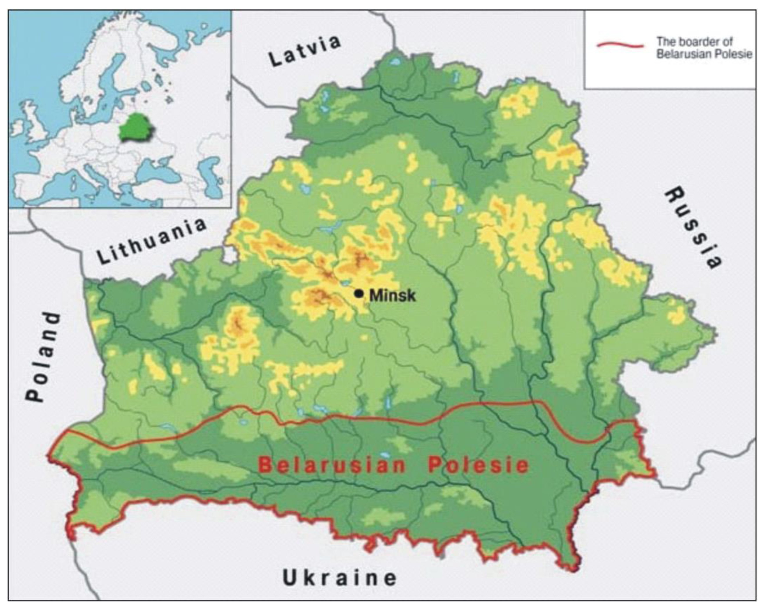
1. Introduction
2. Materials and Methods
3. Results
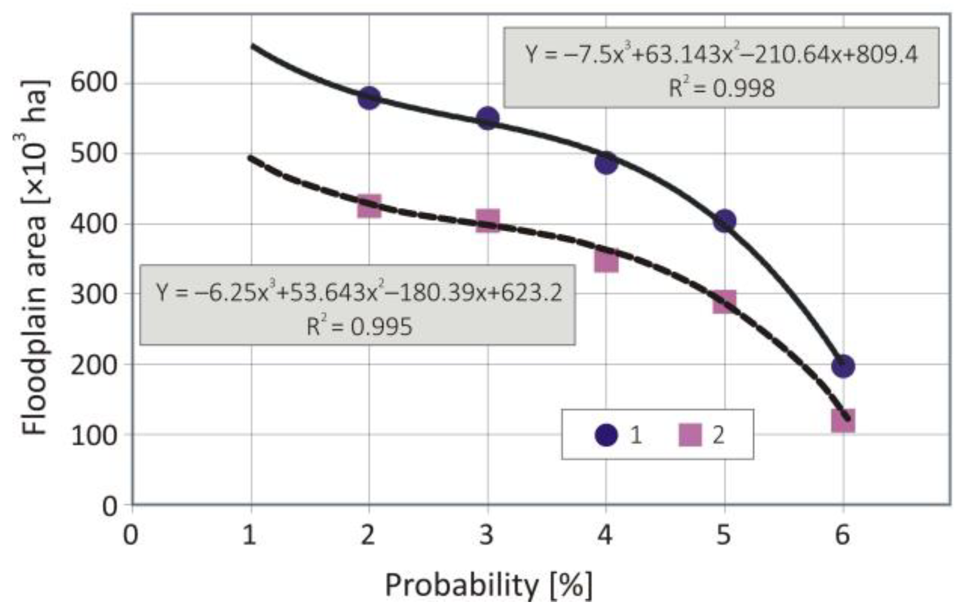
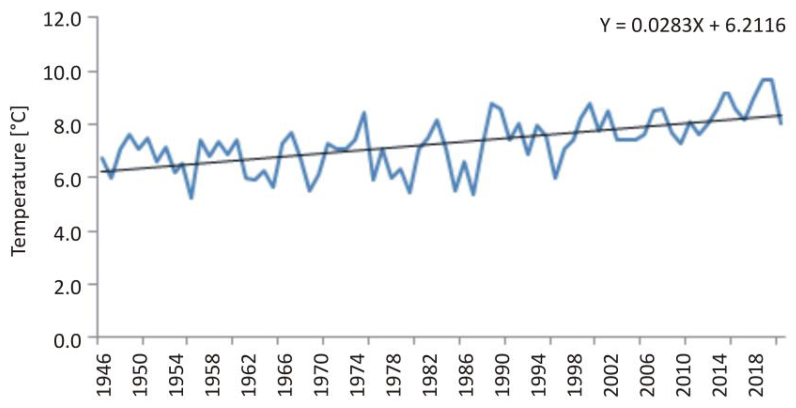
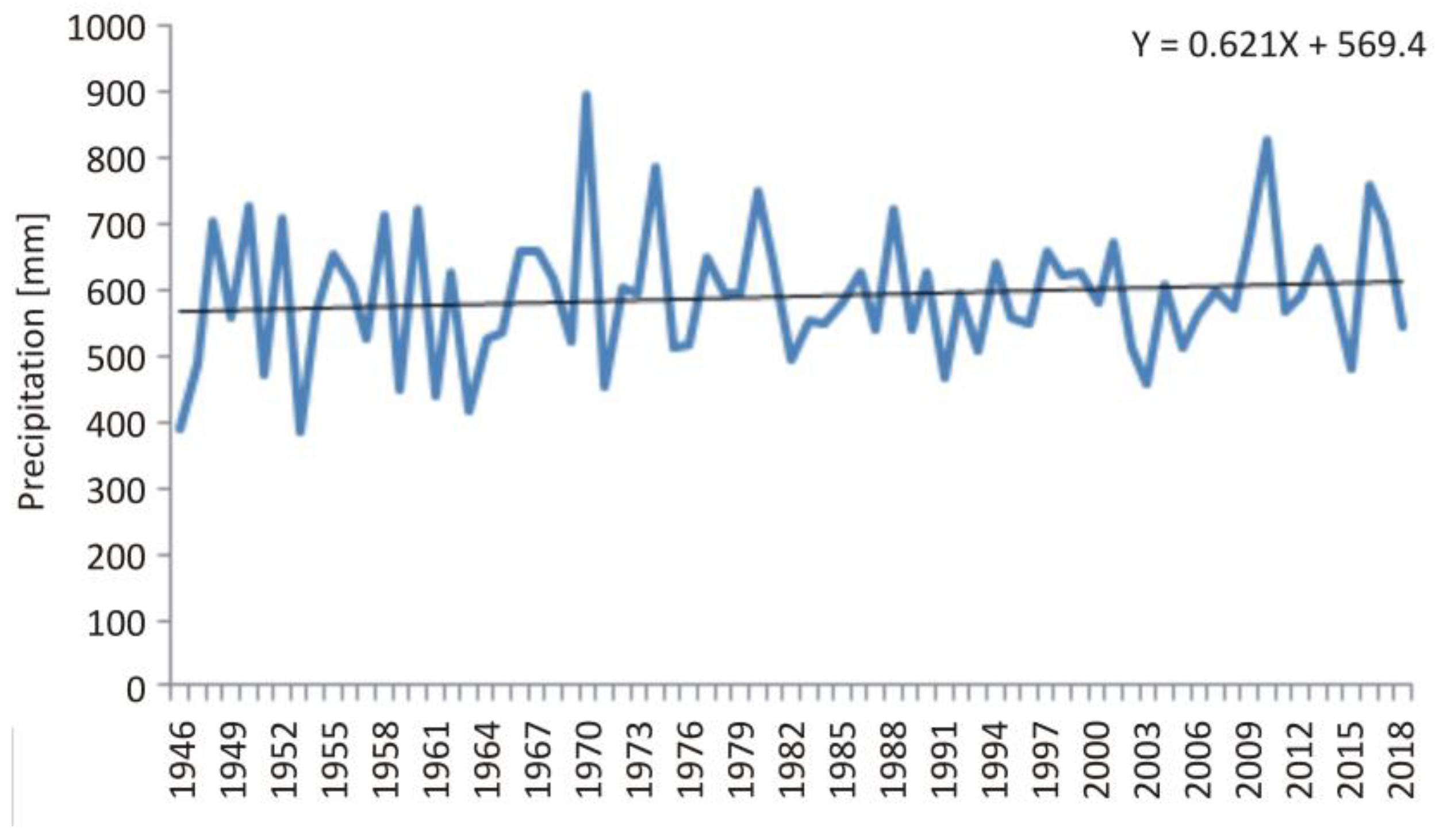
3.1. Surface Water Resources Current State
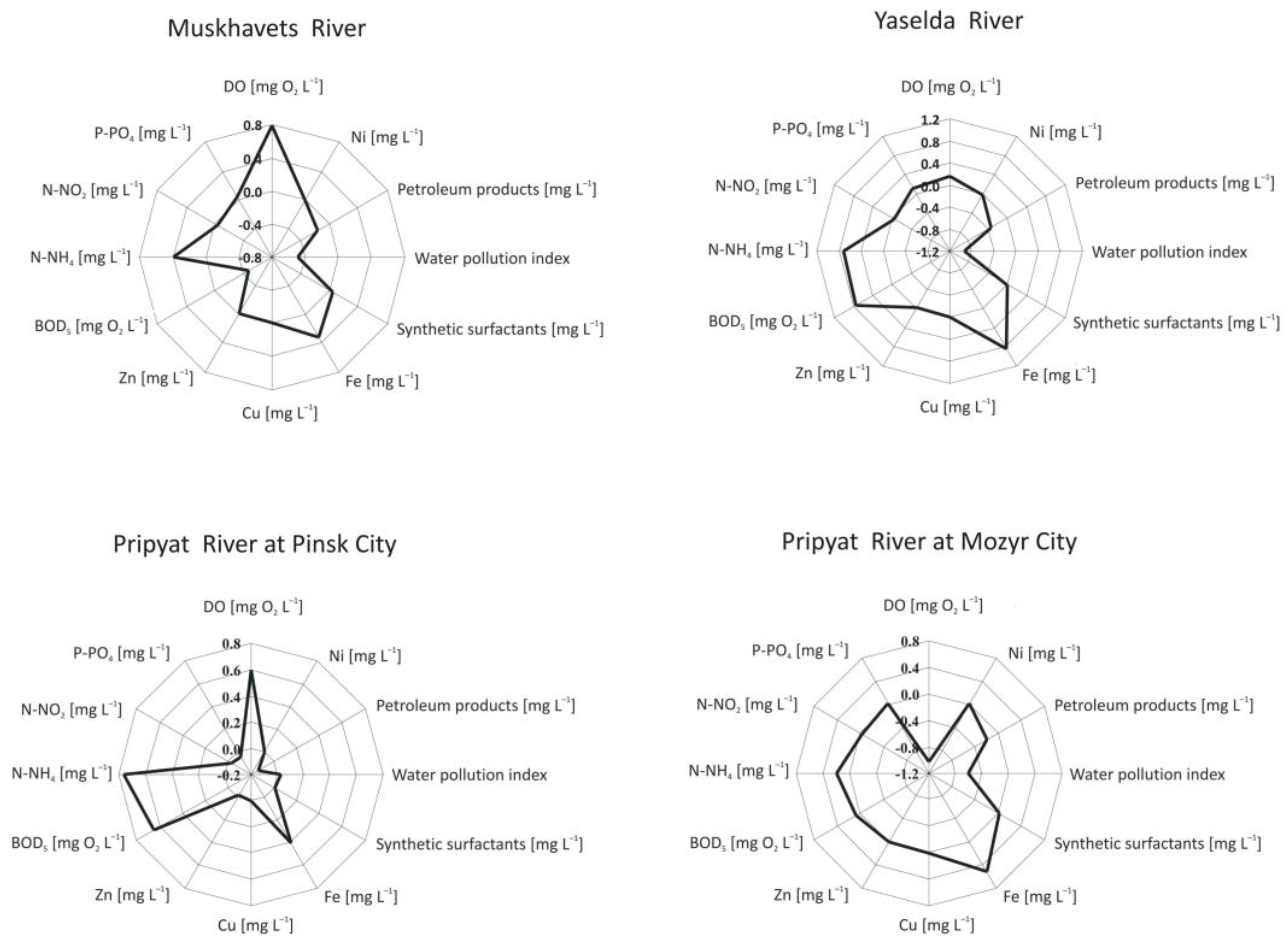
3.2. Quality of Natural Waters Analysis
4. Discussion
5. Conclusions
- prevention and reduction of negative consequences from floods;
- improving the quality of natural waters;
- protection water resources during the design, construction, and operation of public facilities;
- management the regime of natural waters that ensures the biospheric functioning of natural ecological systems;
- creation the basin schemes for water resources management in Polesie.
Author Contributions
Funding
Institutional Review Board Statement
Informed Consent Statement
Data Availability Statement
Conflicts of Interest
References
- Harding, R.; Weedon, G.; van Lanen, H.; Clark, D. The future for global water assessment. J. Hydrol. 2014, 518 Pt B, 186–193. [Google Scholar] [CrossRef]
- Sang, Y.F.; Wang, D.; Wu, J.C.; Zhu, Q.P.; Wang, L. Human impacts on runoff regime of middle and lower Yellow River. Water Sci. Eng. 2011, 4, 36–45. [Google Scholar]
- Stagl, J.; Hattermann, F. Impacts of climate change on the hydrological regime of the Danube River and its tributaries using an ensemble of climate scenarios. Water 2015, 7, 6139–6172. [Google Scholar] [CrossRef]
- Tomaszewski, E. Impact of Lake Gopło on low-flow regime of the upper Noteć River. Limnol. Rev. 2016, 16, 95–103. [Google Scholar] [CrossRef]
- Volchak, A.; Parfomuk, S.; Sidak, S. Intra-annual runoff distribution in the Pripyat River basin. In Proceedings of the International Conference on Building Energy Conservation, Thermal Safety and Environmental Pollution Control (ICBTE 2020), Brest, Belarus, 29–30 October 2020; Volume 212, pp. 1–10. [Google Scholar]
- Huang, S.; Hattermann, F.; Krysanova, V.; Bronstert, A. Projections of climate change impacts on river flood conditions in Germany by combining three different RCMs with a regional eco-hydrological model. Clim. Change 2013, 116, 631–663. [Google Scholar] [CrossRef]
- Wortmann, M.; Krysanova, V.; Kundzewicz, Z.; Su, B.; Li, X. Assessing the influence of the Merzbacher Lake outburst floods on discharge using the hydrological model SWIM in the Aksu headwaters. Kyrgyzstan/NW China. Hydrol. Proc. 2014, 28, 6337–6350. [Google Scholar] [CrossRef]
- Volchak, A.; Parfomuk, S. Assessment of changes in the Viliya River runoff on the territory of Belarus. Limnol. Rev. 2018, 18, 185–196. [Google Scholar] [CrossRef]
- Yatsukhno, V. Rural Development in the Belarusian Polesie Area. In Rural Development and Land Use; Ecosystem Health and Sustainable Agriculture; Karlsson, I., Rydén, L., Eds.; Uppsala University: Uppsala, Sweden, 2012; Volume 3, pp. 52–57. [Google Scholar]
- Mezentsev, V.; Belonenko, G.; Karnatsevich, I.; Loskutov, V. Gidrologicheskiye Raschety v Meliorativnykh Tselyakh (Hydrological Calculations for Land Reclamation Purposes); Izdat. Omsk: Omsk, Russia, 1980; 84p. (In Russian) [Google Scholar]
- Volchek, A.; Parfomuk, S. Ocenka transformacii vodnogo rezhima malykh rek Belorusskogo Polesia pod vozdeistvem prirodnykh i antropogennykh faktorov (na primere r. Jaselda) (Evaluation of water regime transformation in minor rivers of Belarusian Polesye under the influence of natural and anthropogenic factors based on the example of the Yaselda River). Vodn. Khozaistvo Ross. 2007, 1, 50–62. (In Russian) [Google Scholar]
- Dzisko, N.A.; Kyrlovich, M.M.; Malashevich, Y.V. Blakitnaya Kniga Belarusi: Entsykl. (Blue Book of Belarus: Encyclopedia); BelEn: Minsk, Belarus, 1994; 415p. (In Belarussian) [Google Scholar]
- Vasilchenko, G.V.; Grinevich, L.A. Opyt bor’by s navodneniyami v SSSR i zadachi inzhenernoy zashchity ot zatopleniy sel’khozugodiy v poyme r. Pripyati (The experience of flood control in the USSR and the tasks of engineering protection against flooding of farmland in the floodplain of the Pripyat river). Probl. Poles. 1984, 9, 20–27. (In Russian) [Google Scholar]
- Shvets, G.I. Vydajushchiesia Gidrokogicheskie Javlenija na Jugo-Zapade SSSR (Outstanding Hydrological Phenomena in the South-West of the USSR); Hydrometeoizdat: Saint Petersburg, Russia, 1972; 243p. (In Russian) [Google Scholar]
- Kadatskaya, O.V. Landshaftnyye Vody v Usloviyakh Tekhnogeneza (Landscape Waters in the Conditions of Technogenesis); Belarusian Nauka: Minsk, Belarus, 2005; 347p. (In Russian)
- State Water Cadaster: Water Resources, Their Use and Water Quality; TSNIIKIVR: Minsk, Belarus, 2020; 106p.


| Runoff Type | Variability Coefficients | µp = 1% | µp = 5% | µp = 50% | µp = 95% | µp = 99% |
|---|---|---|---|---|---|---|
| Annual | 0.32 | 7.17 | 5.97 | 3.85 | 2.22 | 1.77 |
| Maximum | 0.89 | 73.4 | 44.3 | 18.12 | 5.06 | 3.40 |
| Minimum summer-autumn | 0.51 | 4.23 | 2.98 | 1.53 | 0.68 | 0.52 |
| Minimum winter | 0.76 | 5.37 | 3.31 | 1.48 | 0.52 | 0.39 |
| Annual | 0.32 | 7.17 | 5.97 | 3.85 | 2.22 | 1.77 |
| Year | 1845 | 1877 | 1895 | 1888 | 1889 | 1940 | 1979 | 1932 | 1970 | 1958 |
|---|---|---|---|---|---|---|---|---|---|---|
| Q [m3 s−1] | 11,000 | 7500 | 5670 | 5100 | 4700 | 4520 | 4310 | 4220 | 4140 | 4010 |
| P [%] | 0.8 | 1.6 | 2.3 | 3.1 | 3.9 | 4.7 | 5.4 | 6.2 | 7.0 | 7.6 |
| River | Ca2+ | Mg2+ | Na+ + K+ | HCO3− | SO42− | Cl− | NO3− | NO2− | Fe | Total Dissolved Salts |
|---|---|---|---|---|---|---|---|---|---|---|
| Shchara | 50.1 | 7.8 | 1.0 | 186.0 | 5.9 | 0.3 | 0.08 | 0.006 | 0.71 | 251.2 |
| Grivda | 53.5 | 7.4 | 2.2 | 190.4 | 8.5 | 2.4 | 0.05 | – | 0.5 | 264.4 |
| Vedrich | 63.8 | 10.1 | 1.5 | 226.3 | 4.4 | 3.2 | 2.00 | 0.058 | 1.12 | 311.4 |
| Ryta | 40.5 | 2.3 | – | 115.9 | 4.0 | 1.9 | 0.35 | 0.006 | 1.62 | 165.0 |
| Lesnaya | 53.0 | 4.6 | – | 171.4 | 3.4 | 0.8 | – | 0.002 | 0.71 | 233.2 |
| Pripyat | 73.7 | 3.0 | 0.5 | 233.7 | 3.7 | 1.4 | 0.07 | 0.001 | 0.48 | 316.1 |
| Yaselda | 44.5 | 5.7 | – | 139.1 | 2.1 | 0.9 | – | 0.005 | 2.12 | 192.3 |
| Goryn | 70 | 9.9 | 5 | 243.4 | 15.7 | 6.5 | – | 0.002 | 0.38 | 350.5 |
| Oressa | 42.7 | 7.4 | 2.2 | 148.2 | 10.7 | 6.0 | 0.50 | 0.105 | 3.50 | 217.8 |
| Month | 1 | 2 | 3 | 4 | 5 | 6 | 7 | 8 | 9 | 10 | 11 | 12 | Year |
|---|---|---|---|---|---|---|---|---|---|---|---|---|---|
| I | −0.03 | 0.00 | 0.04 | −0.02 | 0.01 | −0.03 | −0.03 | −0.01 | −0.03 | 0.03 | 0.02 | 0.00 | −0.01 |
| II | −0.06 | −0.03 | 0.03 | 0.03 | 0.01 | 0.08 | 0.06 | 0.06 | 0.06 | 0.04 | 0.12 | 0.09 | 0.04 |
| III | −5.22 | −4.76 | −0.30 | 7.00 | 12.99 | 16.40 | 17.63 | 16.90 | 12.68 | 7.11 | 2.09 | −1.99 | 6.71 |
| IV | −2.69 | −1.76 | 2.06 | 8.26 | 13.68 | 17.15 | 19.11 | 18.22 | 13.13 | 7.77 | 2.69 | −1.37 | 8.03 |
| Month | 1 | 2 | 3 | 4 | 5 | 6 | 7 | 8 | 9 | 10 | 11 | 12 | Year |
|---|---|---|---|---|---|---|---|---|---|---|---|---|---|
| I | 0.54 | −0.15 | 0.10 | 0.05 | 0.31 | −0.36 | 0.43 | −0.36 | 0.20 | 0.07 | −0.09 | 0.35 | 1.09 |
| II | 0.80 | −0.08 | −0.21 | 0.15 | 0.45 | −0.04 | 0.89 | −0.51 | −0.50 | 0.45 | −0.12 | 0.36 | 1.65 |
| III | 34.86 | 30.63 | 28.17 | 37.82 | 55.25 | 75.31 | 72.24 | 74.05 | 49.54 | 42.85 | 43.57 | 42.11 | 586.38 |
| IV | 36.65 | 35.44 | 35.44 | 39.50 | 58.68 | 65.55 | 86.44 | 60.74 | 57.48 | 41.77 | 41.44 | 41.61 | 600.73 |
| V | 1.79 | 4.81 | 7.27 | 1.68 | 3.43 | −9.76 | 14.20 | −13.31 | 7.95 | −1.07 | −2.14 | −0.49 | 14.35 |
Disclaimer/Publisher’s Note: The statements, opinions and data contained in all publications are solely those of the individual author(s) and contributor(s) and not of MDPI and/or the editor(s). MDPI and/or the editor(s) disclaim responsibility for any injury to people or property resulting from any ideas, methods, instructions or products referred to in the content. |
© 2023 by the authors. Licensee MDPI, Basel, Switzerland. This article is an open access article distributed under the terms and conditions of the Creative Commons Attribution (CC BY) license (https://creativecommons.org/licenses/by/4.0/).
Share and Cite
Kirvel, I.; Volchak, A.; Parfomuk, S.; Kirvel, P. Environmental Risks of Water Resources in the Belarusian Polesie. Limnol. Rev. 2023, 23, 21-32. https://doi.org/10.3390/limnolrev23010002
Kirvel I, Volchak A, Parfomuk S, Kirvel P. Environmental Risks of Water Resources in the Belarusian Polesie. Limnological Review. 2023; 23(1):21-32. https://doi.org/10.3390/limnolrev23010002
Chicago/Turabian StyleKirvel, Ivan, Alexander Volchak, Sergey Parfomuk, and Pavel Kirvel. 2023. "Environmental Risks of Water Resources in the Belarusian Polesie" Limnological Review 23, no. 1: 21-32. https://doi.org/10.3390/limnolrev23010002
APA StyleKirvel, I., Volchak, A., Parfomuk, S., & Kirvel, P. (2023). Environmental Risks of Water Resources in the Belarusian Polesie. Limnological Review, 23(1), 21-32. https://doi.org/10.3390/limnolrev23010002