
Article

Tectonic Evolution of the Tazhong No. 2 Fault Zone, Tarim Basin: Along-Strike Segmentation, Vertical Layered Deformation, and Implications for Hydrocarbon Accumulation
1
School of Earth Sciences, Northeast Petroleum University, Daqing 163318, China
2
PetroChina Research Institute of Petroleum Exploration and Development, Beijing 100083, China
3
College of Energy, Chengdu University of Technology, Chengdu 610059, China
*
Author to whom correspondence should be addressed.
Processes 2026, 14(17), 2754; https://doi.org/10.3390/pr14172754
Submission received: 10 July 2026 / Revised: 22 August 2026 / Accepted: 26 August 2026 / Published: 28 August 2026
(This article belongs to the Section Petroleum and Low-Carbon Energy Process Engineering)

Abstract

The Tazhong No. 2 fault zone is a major fault zone in the Tazhong area, and studying its structural characteristics is of great significance for hydrocarbon exploration. Based on detailed structural interpretation of 2D and 3D seismic data, this study suggests that the Tazhong No. 2 fault zone exhibits distinct segmented deformation characteristics and can be divided into four segments along strike, with the individual structural segments bounded by NE-trending strike-slip faults. The eastern and western parts of the Tazhong No. 2 fault zone differ in their evolutionary characteristics: during the early stage, deformation was intense in the east and relatively weak in the west, whereas during the late stage, the central segment was more active while the eastern and western segments were essentially inactive. Vertically, the fault zone displays stratified deformation: taking the Middle–Lower Cambrian evaporites as the boundary, the suprasalt strata are more strongly deformed than the subsalt strata. The segmented and layered deformation characteristics of the Tazhong No. 2 fault zone are mainly controlled by factors such as the basement structure, the Middle–Lower Cambrian evaporites, and regional tectonic events. Based on the segment-specific accumulation–evolution model, the shallow fault–lithologic traps and volcanic-rock-related traps in the west, the subsalt structural traps, and the buried-hill interior and drape traps are all favorable exploration targets.

1. Introduction

Large fault zones commonly exhibit along-strike segmented deformation, and structural segmentation has long attracted the attention of researchers worldwide [1,2,3]. A fault zone forms through the growth, interaction, and linkage of several individual fault segments [4,5], and its segment architecture is critical to understanding the development of the entire fault zone. Fault segmentation is significant not only for seismicity and geohazard prediction but is also closely related to the migration and accumulation of fluids such as hydrocarbons [6]. Previous studies have extensively investigated structural segmentation through means such as seismic-section interpretation and analog (physical) modeling [7]. Meanwhile, controlled by factors such as regional detachment layers, large faults also display pronounced layered deformation in cross-section [8]. Taking the Kuqa foreland fold-and-thrust belt as an example, some researchers have used numerical simulation to explore the influence of the subsalt detachment on structural geometry and evolution, revealing differences in deformation style among the suprasalt, salt, and subsalt structural layers [9,10,11]. For the Tarim Basin as a whole, from the Middle Caledonian to the Hercynian, faulting in the Tadong (eastern Tarim), Tazhong (central Tarim), Tanggubasi, Bachu, and Maigaiti areas was dominated by thrusting; since the Indosinian, the foreland areas have further developed imbricate thrust belts, fold-and-thrust belts, duplexes, and salt-related structures, with detachment zones and regional unconformities controlling the stratigraphic levels at which faults developed [12]. Overall, current research on structural segmentation and layered deformation has focused mainly on the fold-and-thrust belts of foreland basins, whereas the systematic characterization of the differential deformation of thrust faults in intracratonic uplifts remains relatively weak.
In the platform-basin region of the Tarim Basin, the Cambrian-Ordovician marine carbonates are generally buried at depths of 5000–9000 m and constitute a core replacement domain for reserve and production growth in deep to ultra-deep hydrocarbon exploration. Hydrocarbons occur as composite accumulations with faults as the dominant controlling factor, and more than 80% of the reserves in the Tazhong Uplift are enriched along fault zones [13,14,15]. The Tazhong Uplift is characterized by a complex fault system in which thrust faults and later strike-slip faults coexist and mutually crosscut; the scale, architecture, and nature of these faults directly control the distribution of fracture–cavity reservoirs and the differential enrichment of hydrocarbons [16,17,18,19]. Studies have shown that faults in the Tarim Basin display vertical layered deformation—defined by tectonic transition periods and lithological interfaces—as well as along-strike segmented evolution and that such “layered and segmented” differential deformation is the fundamental cause of the reservoir and hydrocarbon-enrichment differences among fault zones within the same area [20,21]. Therefore, the detailed characterization of the layered and segmented differential deformation of faults provides the geological basis for revealing reservoir heterogeneity and for optimizing favorable exploration targets [22].
As a peripheral foreland uplift formed in the Paleozoic, the Tazhong Uplift has undergone multi-stage tectonic evolution during the Caledonian, Hercynian, Indosinian–Yanshanian, and Himalayan periods and has long been a principal focus of hydrocarbon exploration in the Tarim Basin [23]. The transition from early regional compression during the Middle Caledonian to a strike-slip-dominated stress regime during the Late Caledonian-Early Hercynian [12,24] provides a key geodynamic background for understanding the development of NE-trending strike-slip faults, which are interpreted as natural segment boundaries of fault zones in the Tazhong area. The Tazhong No. 2 fault zone is an important major fault zone in the Tazhong area, composed of one large-scale thrust fault and several nearly parallel backthrusts [25]. It has been a structural high since the Early Paleozoic and represents a favorable target area for hydrocarbon migration and accumulation, characterized by long-term inherited activity [26,27]. Moreover, the distinctive structural framework of this area is further complicated by pronounced basement-cover decoupling. This decoupling was primarily facilitated by Cambrian evaporite, which played a crucial role in the structural inversion and differential deformation of the overlying strata. Compared with the more thoroughly studied Tazhong No. 1 and No. 10 fault zones, both of which display pronounced along-strike segmentation, the Tazhong No. 2 fault zone similarly exhibits significant along-strike variations in deformation intensity and structural style. However, its along-strike segmented deformation, the differential superposition among structural layers, and the resulting reservoir and trap differences have not yet been systematically characterized. The structure is complex and remains poorly studied overall, and the coupling relationship between fault differential deformation and favorable exploration targets still needs to be further clarified [28]. Although existing studies have provided valuable insights into the regional hydrocarbon migration patterns in the Tazhong area [29], the three-dimensional kinematic interactions among basement uplift, variations in the thickness and distribution of Cambrian evaporites, and later strike-slip tear faults remain poorly understood, hindering exploration and development in this area.
In view of this, the present study takes the Tazhong No. 2 fault zone as its research object. Based on the detailed structural interpretation of high-resolution 2D and 3D seismic data and integrated with the regional tectonic evolution and production performance data, this study systematically characterizes the vertical layering and lateral segmentation of the differential deformation of the fault zone through the identification of its geometric features at different sections, clarifies its control on hydrocarbon accumulation, and, on this basis, optimizes favorable exploration targets, so as to provide the scientific basis needed for exploration breakthroughs in the Tazhong No. 2 fault zone and, more broadly, in the Tazhong Uplift.

2. Geological Background

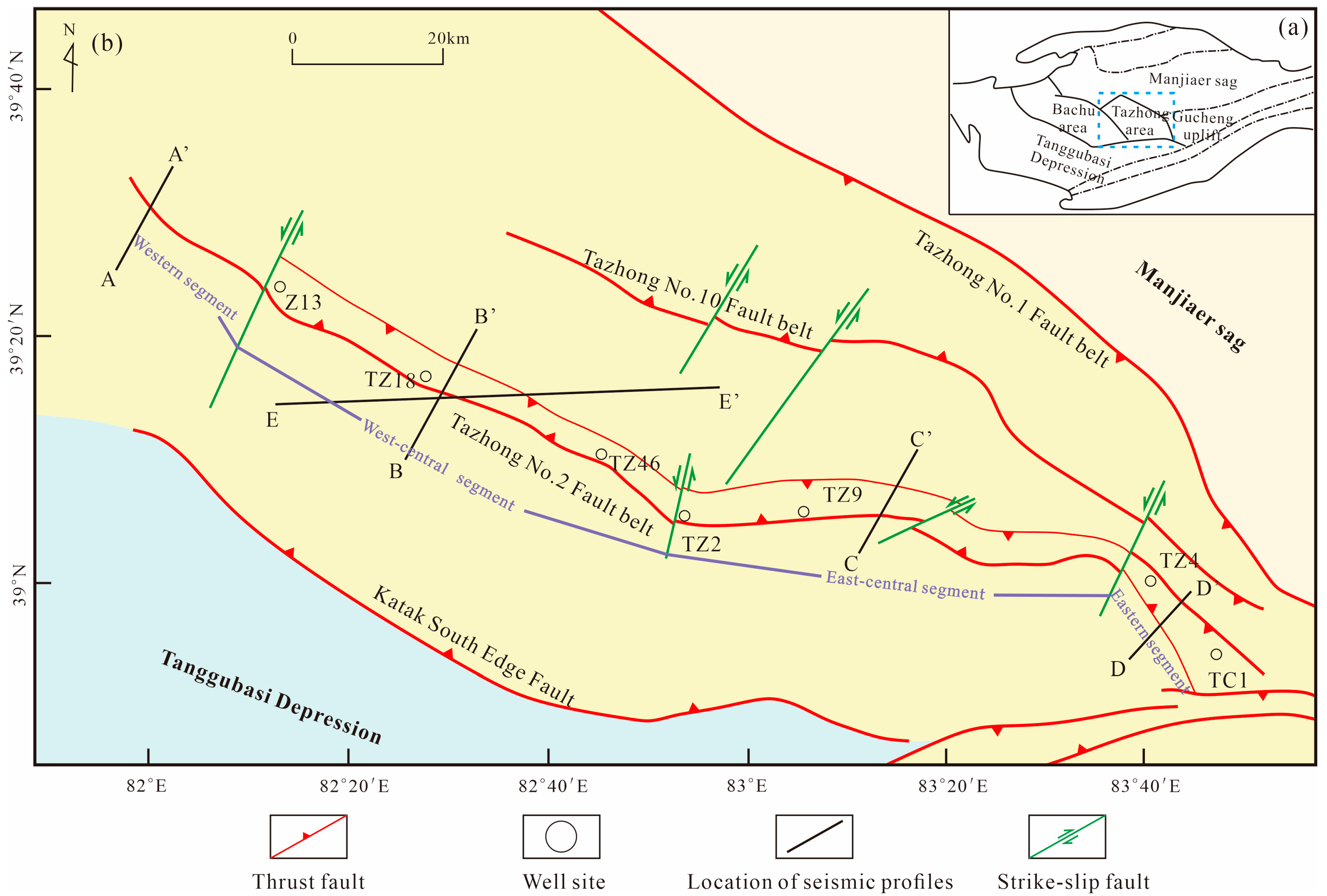
The Tazhong Uplift is a secondary tectonic unit of the Central Uplift Belt of the Tarim Basin. It is bounded to the north by the Manjiaer Sag, transitions southward into the Tanggubasi Depression as a slope, connects westward to the Bachu area across the Tumuxiuke Fault, and adjoins the Tadong (eastern Tarim) area (the Gucheng uplift) to the east (Figure 1a), covering an area of approximately 2.4 × 10⁴ km2.
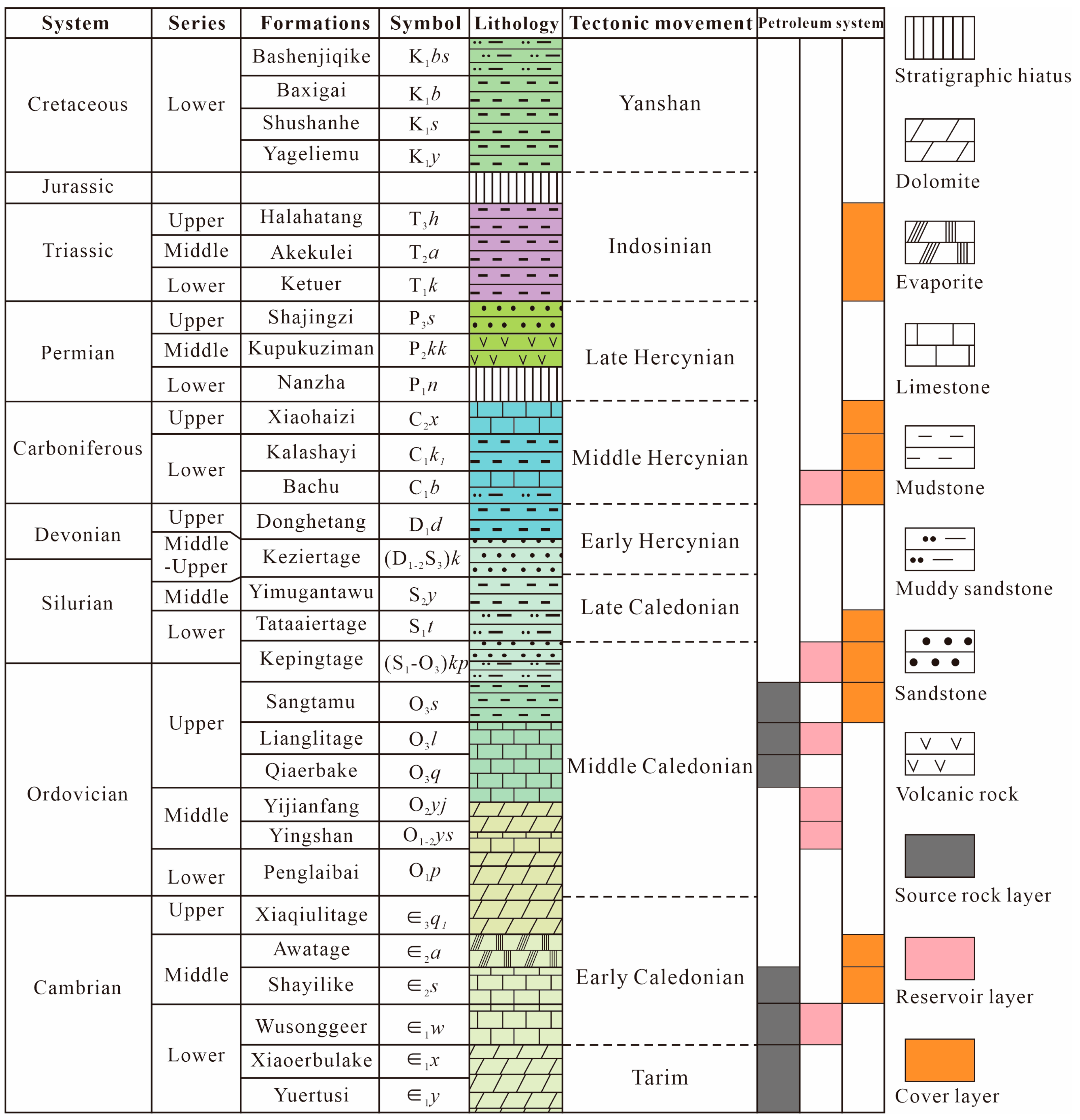
The Paleozoic succession is relatively complete, with the Lower Permian and Jurassic absent, and a suite of evaporites developed in the Middle-Lower Cambrian (Figure 2) constitutes an important detachment horizon in the area. In terms of petroleum geology, the Tazhong Uplift developed, from bottom to top, multiple hydrocarbon-bearing sequences, including Cambrian-Ordovician marine carbonates, Silurian clastics, and Devonian-Carboniferous clastics. The principal exploration targets are the Paleozoic clastic and carbonate rocks, with the carbonates dominated by the Ordovician Lianglitage and Yingshan formations [30]. As a first-order fault that controls the framework of the uplift, the fault system in which the Tazhong No. 2 fault zone is located exerts major control on the reservoir development and hydrocarbon migration–accumulation of the marine carbonates.
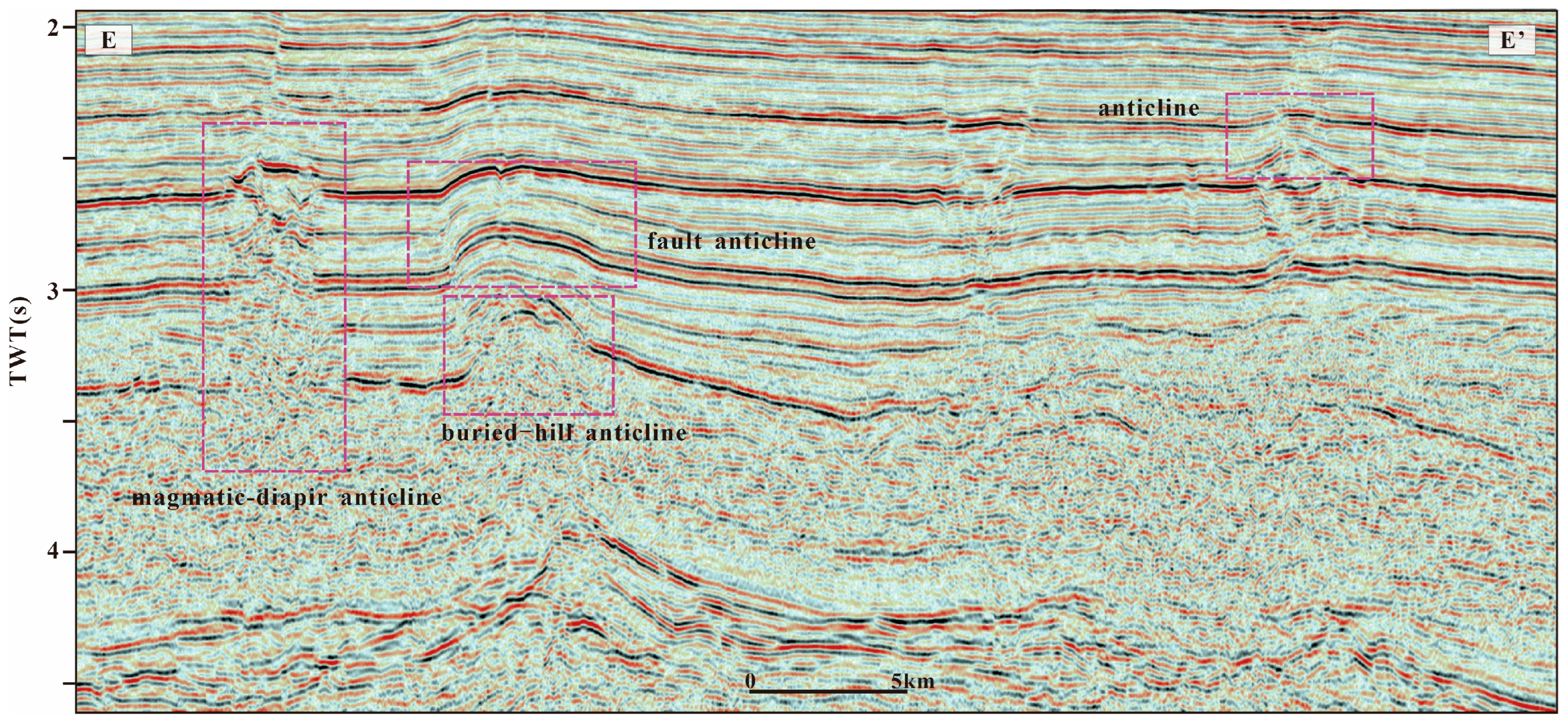
The Tazhong No. 2 fault zone, also known as the Central Main Horst Belt, is located in the central part of the Tazhong Uplift. It is bounded by the Tazhong No. 10 fault zone to the north and the Southern Katak Margin fault zone to the south. The fault system in the study area can be divided into three sets based on strike: NW-trending, NE-trending, and nearly E–W-trending faults. Among these, the NW-trending thrust fault system is dominant, and faults including the Tazhong No. 1, No. 2, and No. 10 fault zones jointly constitute the principal tectonic framework of the Tazhong area. The NE-trending faults belong to a strike-slip fault system and mostly represent tear faults that developed perpendicular to the main thrust belt; their primary role is to accommodate lateral displacement variations between adjacent thrust segments. The nearly E–W-trending thrust faults are relatively small in scale within the study area and exhibit a scattered distribution (Figure 1b). The Tazhong No. 1 and Tazhong No. 2 faults control the basic structural framework of the paleo-uplift; the Central Main Horst Belt and the Tazhong No. 10 structural belt had already formed by the Middle Ordovician and governed the locations of subsequent faulting, exhibiting a distinct multi-stage inherited development [32]. The entire Tazhong No. 2 fault zone is approximately 155 km long and displays an “S”-shaped trace; the highest stratigraphic level offset by the faults becomes progressively younger from east to west, whereas the fault throw increases gradually from west to east, reaching a maximum of about 900 m. Strata within the Tazhong No. 2 fault zone are severely eroded, forming a narrow carbonate buried-hill belt, and a series of structures such as anticlines, buried-hill anticlines, and fault anticlines are developed within the belt (Figure 3). To date, oil and gas shows have been observed in a number of wells in the study area, further confirming that the Tazhong No. 2 fault zone has considerable exploration potential.

3. Data and Methods

3.1. Data

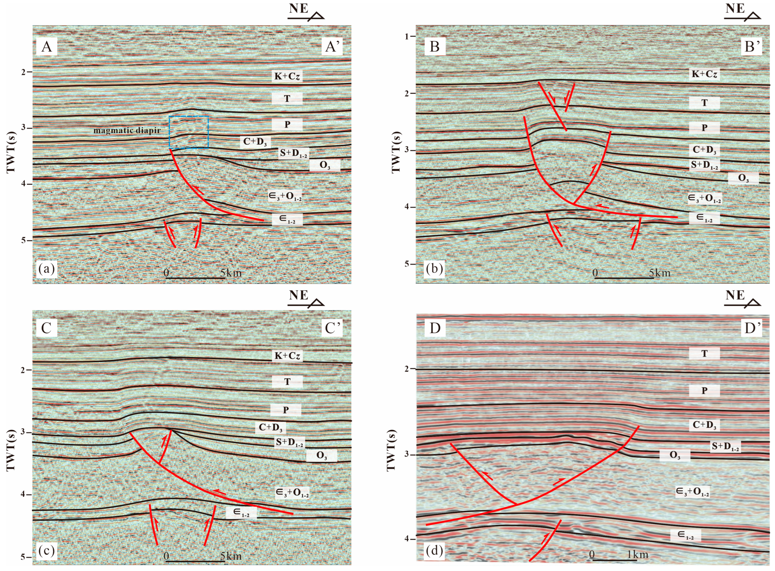
In this study, four key seismic profiles—A-A′, B-B′, C-C′, and D-D′—were selected for detailed analysis, providing critical data for structural interpretation and hydrocarbon accumulation studies. The lengths of the selected profiles are 26.92 km, 29.69 km, 26.74 km, and 5.94 km, respectively. The dominant frequency of the seismic data is 20 Hz, and the two-way travel time (TWT) of the seismic profiles ranges approximately from 1 s to 5 s, covering the sedimentary sequence from the Cambrian basement to the Cenozoic. The data quality is sufficient to identify major boundary faults and the internal structural styles within the fault zones.
Detailed acquisition parameters and full processing flow records are not available, as the final migrated seismic volume was provided by the oilfield as collaborative data. All structural interpretations and analyses in this study are performed in the TWT domain. The core conclusions, including fault geometry, segmentation pattern, and relative evolution stages, do not require precise depth conversion and can be reliably established based on time-domain seismic data. No quantitative depth discussion is included in this manuscript.

3.2. Methods

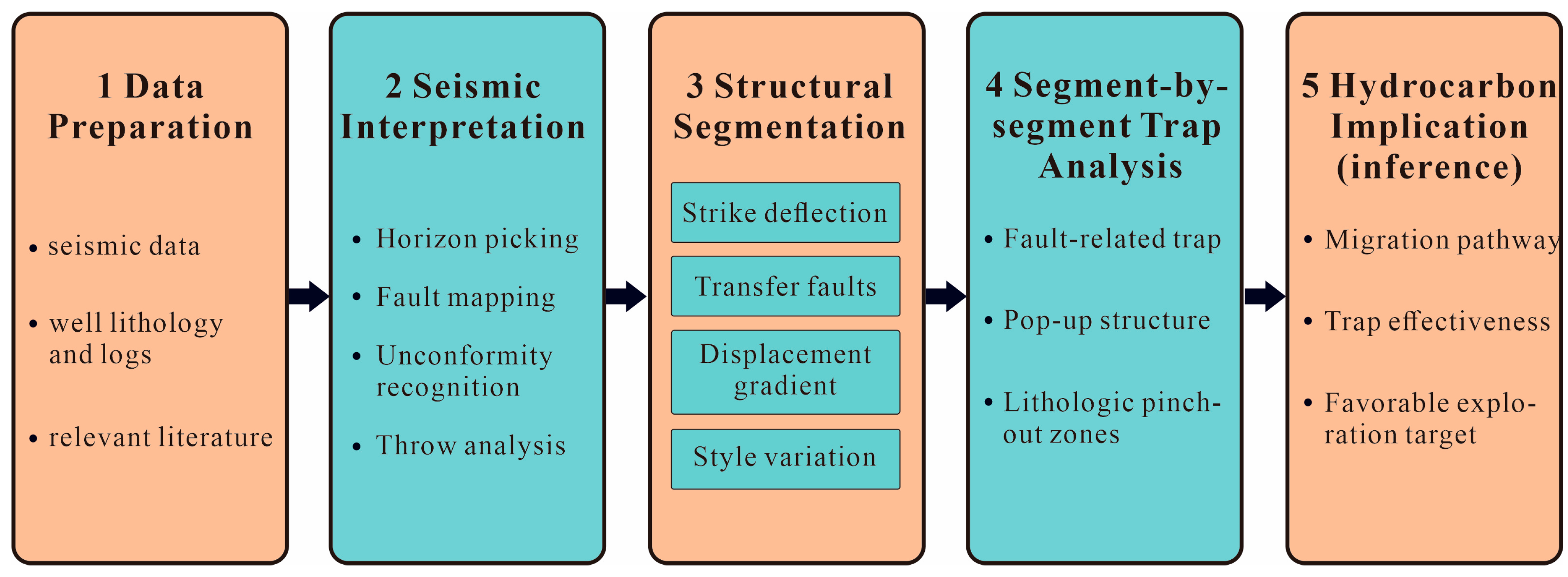
Taking the Tazhong No. 2 fault zone as the study object, this research integrates the newly acquired high-resolution 3D seismic volume, regional 2D backbone seismic lines, and the lithological and well-logging data from exploration wells within the area. With the aid of seismic interpretation and structural mapping, it aims to characterize the static structural-geometric features of the fault zone and to discuss their implications for hydrocarbon migration and entrapment. The specific research procedures are as follows (Figure 4):
(1) Structural segmentation was conducted based on qualitative structural observations derived from seismic data. The main criteria are as follows: (i) Strike deflection of the main fault: Marked changes in the strike of the main boundary fault along its trend serve as important indicators for segment division. (ii) Transverse transfer structures: Tear faults with NE–SW and nearly N–S trends are regarded as natural segment boundaries that cut across the main thrust belt. These faults accommodate displacement differences between adjacent segments. (iii) Fault displacement gradient: Abrupt along-strike changes in fault throw, as interpreted from seismic profile analysis, are used as an auxiliary criterion. Fault displacement generally decreases markedly toward segment boundaries. (iv) Variations in structural style: Significant differences in cross-sectional structural styles (e.g., snake-head structures, pop-up structures) and the geometry of associated secondary faults are used to verify the validity of the segmentation.
Based on the above criteria, the Tazhong No. 2 fault zone is divided into four segments in this study. For each segment, we systematically analyzed its geometry, fault displacement variations, structural styles, and multi-stage deformation history to establish the differential deformation patterns along the fault zone.
(2) Selection of seismic profiles. Fault interpretation was first carried out on a dense grid of inlines and crosslines across the 3D volume, supplemented by the regional 2D backbone lines. The profiles presented in this paper were then selected according to three criteria: (i) they are oriented approximately perpendicular to the local strike of the master fault, so that fault dip, throw, and hanging-wall/footwall geometry are imaged with minimal apparent-dip distortion; (ii) they are distributed so that each of the four structural segments is represented by at least one intra-segment profile, with additional profiles placed across the segment boundaries to image the along-strike changes in fault geometry on which the segmentation is based; and (iii) they intersect, or lie close to, exploration wells, so that the interpreted horizons are tied to lithological and well-logging control, and they lie in areas of good data quality. The displayed sections are therefore intended to be representative of each segment, and the along-strike variability was checked on the intervening interpreted lines before these sections were chosen.
(3) Structural interpretation. The seismic reflection characteristics of key structural interfaces are analyzed in detail to identify unconformities, such as truncation, onlap, toplap, and downlap; the spatial distribution, geometric attitude, and vertical variation in throw of the Tazhong No. 2 fault zone and its derivative faults are determined; and, based on the cross-cutting relationships among faults, the stratigraphic levels at which faults tip out, and growth-index analysis, the combination patterns of the master fault and secondary faults are clarified, and the main stages of fault activity are distinguished. On this basis, a qualitative interpretation of the structural evolution of the fault zone is proposed. It should be emphasized that no restored or balanced cross-sections and no quantitative kinematic modeling were performed in this study; the proposed evolution is an interpretation constrained by the geometric and stratigraphic relationships observed in the seismic data and is not a quantitative kinematic reconstruction. Additionally, we emphasize that this study did not conduct stratigraphic age determination; the stratigraphic ages described in the subsequent sections are primarily based on previous regional stratigraphic division schemes for the Tarim Basin [33,34,35]. We have added the corresponding citations at the locations where these stratigraphic ages first appear in the text.
(4) Segment-by-segment trap analysis. On the basis of the structural interpretation and in combination with lithological characteristics, a segment-by-segment study is conducted along the strike of the Tazhong No. 2 fault zone to identify the trap types developed at favorable locations, such as footwall uplift-and-tilt sites, fault bends, and lithologic pinch-out zones.
(5) Discussion of accumulation. First, the seismic structural interpretation provides, for each segment, the trap geometry; the timing and duration of fault activity (from tip-out levels and growth indices); and the vertical extent of the fault-related fracture damage zone, i.e., the potential vertical migration pathway. Second, the well and logging data provide the reservoir and seal properties within each trap and the present-day distribution of oil, gas, and water, as indicated by log responses and test results that record evidence of earlier hydrocarbon charge. Third, the timing of hydrocarbon generation, expulsion, and charge is adopted from published constraints on the Tazhong petroleum system—source-rock distribution and maturity, reservoir bitumen, and burial–thermal histories reported in previous studies. These three elements are combined by comparing, segment by segment, the period of activity of the master fault and its derivative faults with the charging periods established in the literature, in order to evaluate whether the fault acted as a migration conduit during charge and whether the traps of that segment were already formed at that time; the present-day hydrocarbon-bearing status of the wells in each segment is then used as a check on the resulting model. No basin- or petroleum-system modeling, no quantitative fault-seal analysis, and no geochemical oil–source correlation were undertaken in this study. The contribution of this study is therefore limited to relating the charge timing established by previous work to the segment-scale structural and trap architecture documented here.

4. Results

In the Tazhong Uplift, previous workers have conducted in-depth research on the segmented deformation of the Tazhong No. 1 fault zone [36], whereas the Tazhong No. 2 fault zone has lacked detailed study. Using the latest 2D and 3D seismic data and detailed structural interpretation, this study reveals that the Tazhong No. 2 fault zone likewise exhibits pronounced segmented deformation. From west to east, it is divided into four segments—the western segment, the west-central segment, the east-central segment, and the eastern segment—with adjacent segments separated by NE-trending strike-slip faults (Figure 1b). Vertically, the Tazhong No. 2 fault zone can be divided into two structural layers bounded by the Middle-Lower Cambrian [33] evaporites: the structural layer below the Middle-Lower Cambrian evaporites (hereafter the subsalt strata) and the structural layer above it (hereafter the suprasalt strata). Influenced by the Middle–Lower Cambrian evaporites, the Tazhong No. 2 fault zone therefore also displays layered deformation.
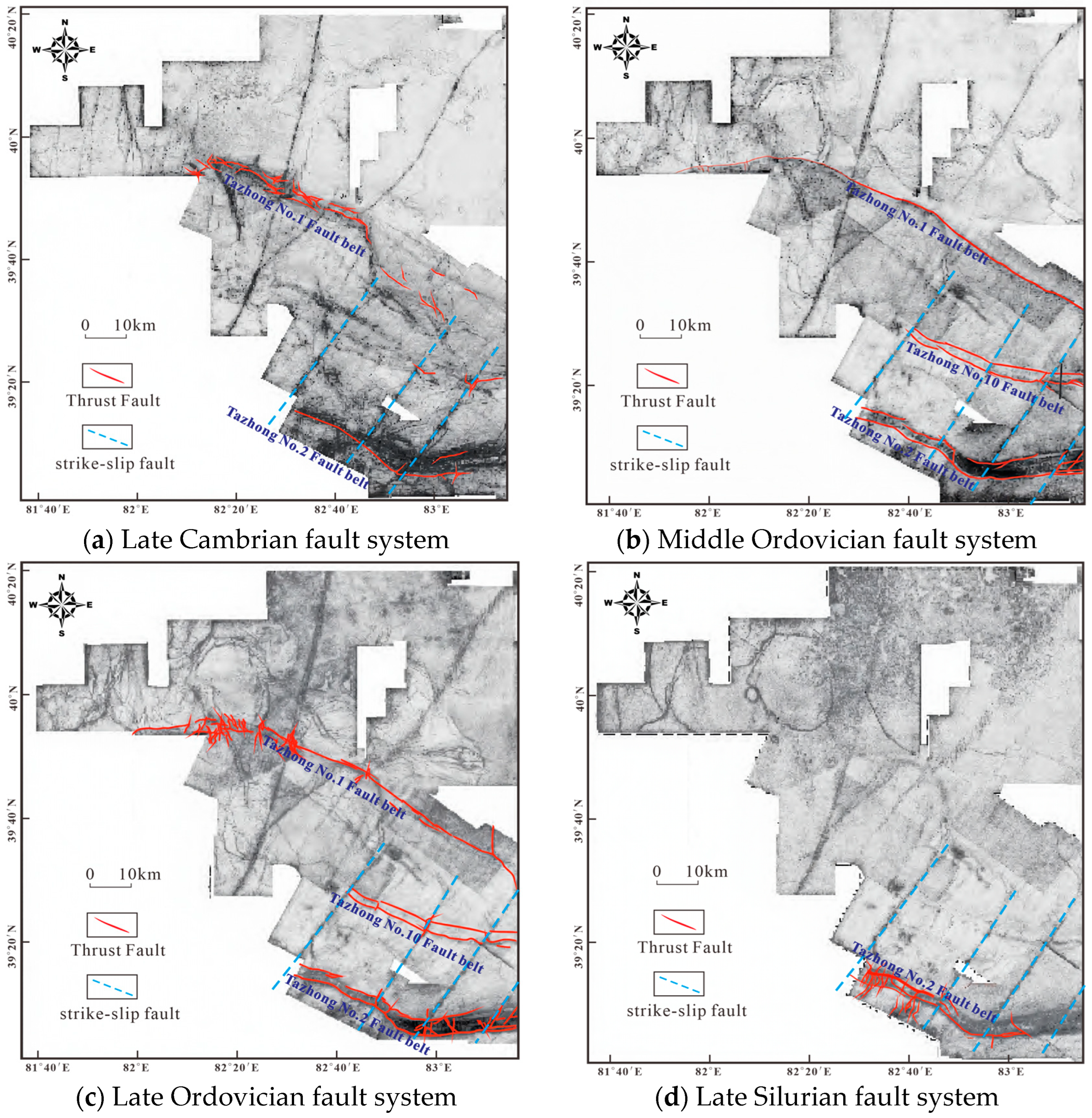
Coherence slices (Figure 5) further show that the Tazhong No. 2 fault zone had not developed to any significant scale by the end of the Cambrian; faulting became pronounced at the end of the Middle Ordovician [34], peaked at the end of the Ordovician, and diminished in scale by the end of the Silurian [35]. Overall, it is a NW-trending arcuate fault zone that is markedly influenced by NE-trending strike-slip faults, was mainly active from the end of the Middle Ordovician to the end of the Ordovician, weakened thereafter, and exhibits long-term inherited activity.
It should be noted that the coherence slices display several prominent lineaments and circular anomalies. The lineaments that are genetically related to the formation of the Tazhong No. 2 fault zone have been marked in the figure. The remaining lineaments are located at considerable distances from the Tazhong No. 2 fault zone and have no direct genetic relationship with its formation and evolution; therefore, they are not analyzed in this study. As for the circular anomalies, the authors did not have access to seismic data covering this area, and thus their nature cannot be identified.

4.1. Static Structural Characteristics of Differential Deformation

On the basis of the coherence-slice analysis, and combined with seismic profiles across the different segments, the differential deformation of the Tazhong No. 2 fault zone was examined in detail. The results are as follows:
  • Western segment. This segment is approximately 30 km long, and its dominant structural style is a snake-head structure formed by a thrust fault. The thrust dips more steeply in its upper part and more gently in its lower part, shows a certain transpressional character, dips to the north, and strikes NWW. The thrust cuts upward into the Carboniferous [35] and dies out downward by detaching within the Middle-Lower Cambrian evaporites, defining it as a detachment thrust (Figure 6a). Fault throw increases gradually from west to east along this segment and terminates eastward against an NE-trending strike-slip fault. In the western segment, the subsalt strata are weakly deformed and faulting is poorly developed, indicating layered deformation. Previous studies have indicated that the Tazhong area experienced large-scale magmatic events [37]. In this structural segment, seismic profiles exhibit relatively chaotic reflection events, which appear as discontinuous, short-axis, strong-amplitude reflections, indicating prominent magmatic intrusion features. Judging from the fault throw and the stratigraphic development, faulting was intense during the late Early Paleozoic to early Late Paleozoic, and the Early Paleozoic strata were strongly eroded; magmatic intrusion occurred in the late Late Paleozoic (Permian) [35]. The absence of obvious growth strata in the Meso-Cenozoic [35] indicates that the western segment of the Tazhong No. 2 fault zone was essentially inactive during the later stages.
  • West-central segment. This segment is approximately 50 km long, and its structural style differs from that of the western segment. The dominant style is a pop-up structure formed by a fault block bounded by a main thrust and a backthrust. The thrust cuts upward into the Permian and dies out downward by detaching within the Middle-Lower Cambrian evaporites; the main thrust dips to the north and strikes NWW, with a steeper upper part and a gentler lower part—consistent with the western segment, i.e., transpressional. The hanging wall of the thrust develops a graben controlled by extensional normal faults, and, influenced by the underlying thrust, the Meso-Cenozoic strata are folded, forming fault-related folds. The subsalt structures are relatively well developed and mainly consist of a horst structure produced by the tectonic inversion, during the Middle Caledonian, of Early Caledonian normal faults; the basic geometry can be described as “a horst bounded by two faults.” A comparison between the throws of the suprasalt and subsalt thrusts shows that the suprasalt strata are more strongly deformed than the subsalt strata (Figure 6b). The evolution of this segment differs from that of the western segment, most notably in the long-lived and multi-stage nature of its faulting. Faulting was intense during the late Early Paleozoic to early Late Paleozoic, and the Early Paleozoic strata were strongly eroded; normal faults developed in the Mesozoic, and in the Cenozoic the thrust was reactivated, with growth strata developed in the Cenozoic succession.
  • East-central segment. This segment is approximately 50 km long, and its structural style is essentially the same as that of the west-central segment, being a pop-up structure, but the fault strike differs (Figure 1b). The main fault dips to the NE and strikes nearly NW; it dies out downward by detaching within the Middle-Lower Cambrian evaporites and cuts upward into the Middle-Lower Devonian, representing a cover-detachment style (Figure 6c). The subsalt features a horst structure controlled by two backthrusts, and, likewise, the suprasalt strata are more strongly deformed than the subsalt strata. The structural evolution of this segment is similar to that of the west-central segment: faulting was intense during the late Early Paleozoic to early Late Paleozoic, with strong erosion of the Early Paleozoic strata; folding occurred in the Mesozoic, and the thrust was reactivated in the Cenozoic, with growth strata developed in the Cenozoic succession.
  • Eastern segment. This segment is approximately 20 km long and is of the cover-detachment style. In contrast to the main faults of the other three segments, its main fault dips in the opposite direction, cutting upward into the Carboniferous and detaching downward within the Middle Cambrian evaporites. The main fault dips to the south and, together with a subordinate north-dipping backthrust, forms a pop-up structure (Figure 6d) with a NW strike. Judging from the stratigraphic and fault development, this segment underwent strong erosion and pronounced peneplanation during the late Early Paleozoic to early Late Paleozoic, with only part of the Upper Ordovician preserved, and weak folding in the late Paleozoic. Typical seismic profiles show that, after Permian deposition, the strata are gently inclined and display essentially no obvious structural deformation. The eastern segment differs markedly from the adjacent east-central segment, with the two segments showing a sharp contrast in both the dip and strike of the main fault. In the east-central segment, the displacement of the main fault gradually decreases eastward and terminates near the segment boundary. In contrast, in the eastern segment, the displacement of the main fault increases eastward from the segment boundary. The strike-slip fault developed between the two segments accommodates this displacement difference and thus acted as a tear fault.
In summary, the NE-trending strike-slip faults form the boundaries between the individual segments and play an important role in the segmentation of the Tazhong No. 2 fault zone. It is noteworthy that these NE-trending strike-slip faults do not appear as obvious flower structures in cross-section but rather as nearly vertical faults. Meanwhile, coherence slices at the end of the Ordovician reveal a relatively pronounced strike-slip component. Based on the displacement variations in the truncated faults on both sides, the NE-trending strike-slip faults are characterized by sinistral strike-slip motion. Segment linkage is of two types: soft linkage and hard linkage. We interpret that these NE-trending faults acted as tear faults during the formation of the Tazhong No. 2 fault zone, producing a hard linkage between adjacent segments, and that they were subsequently modified by adjustments in the stress field, thereby exhibiting multi-stage activity.

4.2. Trap Style Characteristics of Each Segment

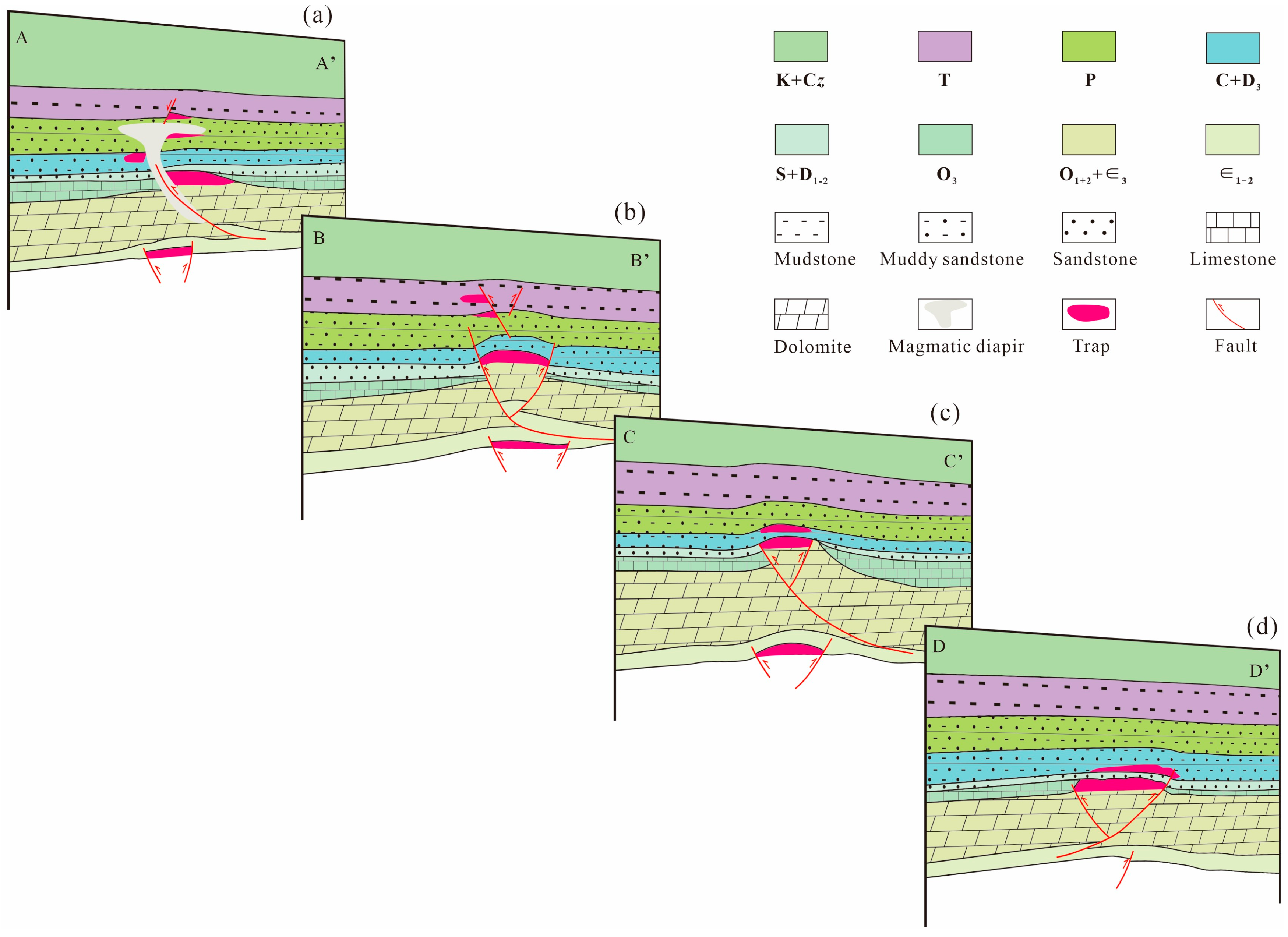
The segmented and layered deformation has produced different types of traps. Controlled by layered deformation, the subsalt traps of the Tazhong No. 2 fault zone are mainly fault-controlled fault-anticline traps and fault-block traps (Figure 7), whereas the suprasalt traps are of more diverse types. In the west, magmatic intrusion occurred during the Permian [37]. Magma ascended along faults, destroying or modifying pre-existing traps and forming magmatic diapirs and related traps (Figure 7a); in the central part, fault–lithologic traps developed (Figure 7b,c); and in the east, drape-structure traps developed (Figure 7d), such as the traps developed in the Carboniferous of the Tazhong No. 4 oil and gas field. Affected by the Late Caledonian–Early Hercynian tectonic movements, the hanging wall of the Tazhong No. II fault zone underwent intense erosion, and karst traps developed.

4.3. Regional Tectonic Evolution Characteristics

The formation and evolution of the Tazhong No. 2 fault zone were controlled by the influence of multiple stages of surrounding tectonic events. Based on the regional geodynamic background and seismic profile interpretation, the study area is divided into six evolutionary stages. For these stages, the structural framework, inferred orientations of the principal stress axes, and structural imprints produced within the study area are described.
(1) Early Caledonian: extensional stage. Previous studies have shown that during the deposition of the Cambrian carbonate-evaporite strata, the Tazhong area was situated in an intra-cratonic basin setting, where a series of NW-trending normal faults developed [38]. The maximum tensile stress is inferred to have been approximately N–S-directed. This stress regime produced the subsalt normal faults that developed early in each segment; these faults were subsequently inverted. By the end of the Cambrian, the precursor of the Tazhong No. 2 fault zone gradually formed (Figure 5a).
(2) Middle Caledonian: main compressional stage. Compression propagated toward the basin interior in response to collision events along the southwestern margin of the Tarim Plate. Within the study area, the maximum principal stress is inferred to have been nearly N–S-directed. This orientation is consistent with the geometry observed in the study area: the main faults strike NW, approximately perpendicular to the inferred shortening direction. During this period, the Early Caledonian subsalt normal faults were inverted, forming a horst bounded by two faults in the central part (Figure 6a). The main displacement of the fault zone was largely acquired during this stage (Figure 5b,c).
(3) Late Caledonian–Early Hercynian: weakened compression and strike-slip uplift stage. During this period, the regional stress field changed from pure compression to a transpressional strike-slip regime, with continued shortening accompanied by a strike-slip component [12]. Under the combined influence of continued subduction of the South Tianshan Ocean and sinistral strike-slip along the Altyn Tagh tectonic belt, the maximum principal stress rotated from nearly N–S to NE–SW, generating a series of NE-trending strike-slip faults. Associated with regional uplift during this stage, the Lower Paleozoic strata in all four segments underwent intense denudation. The eastern segment was denuded particularly strongly, such that only part of the Upper Ordovician was preserved, resulting in pronounced peneplanation.
(4) Late Hercynian: magmatism and weak compression stage. During this period, compression weakened, and only a limited number of faults developed locally. In the western segment (Figure 6a), intrusions of the Early Permian Tarim Large Igneous Province are observed, indicating significant magmatic activity.
(5) Indosinian–Yanshanian: tectonic quiescence and weak inheritance stage. Tectonic deformation was weak during this stage and caused only limited modification of the geometry and structural framework of the fault zone. In the west-central segment, a graben developed in the hanging wall is bounded by NW-trending normal faults. Deformation during this stage was restricted to strata above the gypsum-salt detachment layer and did not affect the subsalt structural level.
(6) Himalayan: compressional reactivation and selective reactivation stage. Far-field stresses transmitted from the India–Eurasia collision re-established a compressional stress regime, with the maximum principal stress oriented NE. This stress field reactivated the main thrust faults in the west-central and east-central segments, producing fault-related folds and Cenozoic growth strata. In contrast, no Cenozoic growth strata are observed in the western and eastern segments, which remained essentially inactive.
The controls exerted by these successively changing stress fields on the fault zone can be summarized as follows. First, the fault zone is essentially a Middle Caledonian compressional structure—its basic geometry was established under a single nearly N–S-directed shortening regime, and subsequent stages only modified rather than reshaped it. Second, the gypsum-salt detachment layer acted as a mechanical decoupling horizon between the suprasalt and subsalt structural levels throughout the evolution. Consequently, the expression of each stress field differed between the suprasalt and subsalt levels: the suprasalt strata record a complete history of compression, extension, and reactivation, whereas the subsalt strata mainly preserve the inverted normal fault system formed during the Early Caledonian. Third, Himalayan reactivation was not uniformly distributed along strike but was restricted to the two central segments. We attribute this differential behavior to the pre-existing subsalt structural framework—the two central segments are underlain by basement-involved inverted horsts, which provided mechanically favorable buttresses for Cenozoic shortening.

5. Discussion

5.1. Analysis of Factors Controlling Differential Deformation

The segmented and layered deformation characteristics of the Tazhong No. 2 fault zone are mainly controlled by factors such as regional tectonic events, the Middle–Lower Cambrian evaporites, and the basement structure:

5.1.1. Regional Tectonic Events

Regional tectonic events exert important control on the segmented and layered deformation of the Tazhong No. 2 fault zone. The magnitude and direction of the boundary-driving forces lead to differences in frontal deformation and displacement—that is, a non-uniform distribution of stress and strain along the strike of the boundary collision zone [39]—resulting in variable strain among different segments of the Tazhong No. 2 fault zone. During the Middle Caledonian, driven by the closure of the Kunlun Ocean, the main body of the Tazhong No. 2 fault zone was formed and experienced large-scale thrusting [12]. This period was dominated by nearly N–S-directed compression [13], which produced the predominantly NW–SE-trending thrust tectonic framework in the study area. The western and west-central segments underwent more intense thrust deformation during this stage, which is consistent with the relatively large fault displacements observed in cross-sections.
From the Late Caledonian to the Early Hercynian, in response to the progressive closure of the Altyn Ocean, the regional stress field shifted to a NE–SW orientation [40]. During this stage, pre-existing NW-trending thrust faults were reactivated. Concurrently, a series of NE-trending strike-slip faults formed and cut the earlier NW-trending thrust faults, resulting in the segmentation of the Tazhong No. 2 fault zone into multiple segments with differing strikes. Furthermore, because the eastern part of the Tazhong No. 2 fault zone lies closer to the basin margin, it experienced strong tectonic deformation and pronounced denudation; in cross-sections, the preserved Silurian strata are observed to be thinner than those in other segments.
The Late Hercynian was a stage of weak compressional adjustment. During this period, compared with the northern Tarim Basin, the regional compressional stress in the Tazhong area weakened significantly [41]. Tectonic activity mainly led to the secondary reactivation of some existing faults and local structural adjustments, without generating large-scale new fault systems.

5.1.2. The Middle–Lower Cambrian Evaporites

Evaporites exerted an important control on the along-strike segmentation and vertical partitioning of deformation within the Tazhong No. 2 fault zone. In response to tectonic stress, the evaporites underwent differential accumulation, resulting in heterogeneous distribution among different structural segments and consequently producing distinct deformation characteristics between the suprasalt and subsalt strata.
Seismic profiles show that the thickness of evaporite layers varies along the strike of the Tazhong No. 2 fault zone. In the western segment, the evaporite layers are relatively thick and exhibit distinct detachment-thrust characteristics. The suprasalt strata are strongly deformed and develop snake-head structures, whereas the subsalt strata are only weakly deformed, indicating a strong decoupling relationship between the suprasalt and subsalt structural levels. In the west-central and east-central segments, the structural styles are broadly similar: the suprasalt strata develop pop-up structures, whereas the subsalt strata develop horst structures, and the displacements of suprasalt thrust faults are greater than those of subsalt thrust faults. In localized fault-detachment areas of the west-central segment, thickening of evaporites is observed, which may be related to salt flow during nappe emplacement. In the eastern segment, the evaporite layers are relatively thin, the deformation difference between the suprasalt and subsalt strata is small, and the decoupling effect is weak.

5.1.3. The Basement Structure

Basement structures exerted a significant control on the structural segmentation of the Tazhong No. 2 fault zone, which is manifested primarily in two aspects: pre-existing basement faults and basement relief.
Pre-existing basement faults represent important zones of structural weakness. Basement faults are well developed in the Tazhong area [42], and multiple NE-trending faults are visible on late Cambrian coherence slices. Controlled by structural inheritance, these NE-trending basement faults further cut and modified the main fault zone during later tectonic events, thereby consolidating and reinforcing the segmentation pattern of the Tazhong No. 2 fault zone.
Basement relief, in turn, controlled the segmented deformation characteristics through differences in stress partitioning and the development of detachment layers. In basement depression areas, compressional stress tended to concentrate, resulting in large-scale thrust faults and intense deformation, with complex structural styles such as back-thrust-related horsts being common. Meanwhile, the original depositional thickness of evaporites in depression areas was relatively large; during compression, these rocks were prone to plastic flow and accumulated and thickened in anticlinal cores, further promoting complex deformation. In contrast, in basement uplift areas, thrust displacement propagation was impeded, leading to reduced fault throw and lower deformation intensity. The evaporites were thinner, and detachment was weaker, resulting in relatively simple structural styles.
Seismic profile observations show that the western segment experienced stronger deformation and larger fault displacements than the eastern segment. Previous studies have indicated that the thickness of evaporites decreases from west to east [43], which is consistent with the seismic profile observations. It is therefore inferred that the western segment was located in a basement depression area, whereas the eastern segment was located in a basement uplift area.

5.2. Analysis of Favorable Exploration Targets

Data indicate that oil and gas shows in exploration wells along the Tazhong No. II fault zone are active. In the eastern segment of the Tazhong No. 2 fault zone, Well TZ4 has achieved a major exploration breakthrough. In Well Z13 in the western part of the Tazhong No. 2 fault zone, drilling encountered five intervals of oil and gas shows in the Silurian Tataaiertage Formation and three intervals of oil and gas shows in the Ordovician Yingshan Formation, further confirming that the Tazhong No. 2 fault zone is a directional area for hydrocarbon migration and a favorable prospect for hydrocarbon exploration.

5.2.1. Source Rocks

The Tazhong Uplift, in which the Tazhong No. 2 fault zone is located, is bounded to the north by the Manjiaer Sag—the largest hydrocarbon-generating sag in the Tarim Basin. Locally, hydrocarbons are sourced mainly from the deep Cambrian source rocks. At the basin scale, the Lower Cambrian Yuertusi Formation is a widely recognized high-quality marine source rock in the Tarim Basin; its siliceous rocks and overlying shales were deposited in a relatively anoxic, reducing environment, and the combination of high primary productivity and favorable organic-matter preservation provided the material basis for the development of high-quality source rocks [44]. According to an evaluation of the spatial–temporal distribution of the Nanhua–Cambrian source rocks in the Tarim Basin, the area of Cambrian source rocks with a hydrocarbon-generation intensity exceeding 450 × 104 t/km2 reaches 4.5 × 10⁴ km2, and the total hydrocarbon resource of the Cambrian source rocks is approximately 7500 × 108 t oil equivalent [45]. In terms of maturation and hydrocarbon-generation evolution, the oil-generation peak of the principal Cambrian source rocks in the Tazhong Uplift corresponds roughly to the Late Ordovician; because the uplift is buried relatively shallowly compared to the adjacent depression, it has long remained within the “oil window” and has served as an important source of liquid petroleum for the paleo-uplift.

5.2.2. Migration–Conduit System

With regard to the conduit framework, the Tazhong No. 2 fault zone, as a first-order fault controlling the framework of the Tazhong Uplift, together with other large thrust and strike-slip faults within the uplift, forms the backbone conduit network that vertically connects source rocks and reservoirs. Studies show that hydrocarbons in the Tazhong Uplift exhibit composite accumulation characteristics dominated by faults, with more than 80% of the reserves enriched along fault zones [14]; the coupling between fault formation–evolution and accumulation determines the differential nature of the composite hydrocarbon accumulation, and the degree of conduit connectivity, the sufficiency of hydrocarbon charging, and the equilibrium state of fluid accumulation are all governed by the scale and stages of fault activity [14]. In terms of accumulation mechanism, research on the adjacent Aman transitional zone further corroborates this model: the Yuertusi Formation source rocks are vertically superimposed with strike-slip fault-controlled reservoirs and the thick mudstone cap rock of the Sangtamu Formation and are vertically connected through strike-slip faults, together constituting a composite strike-slip fault-controlled petroleum accumulation system of “in situ hydrocarbon generation and vertical migration–accumulation” [8]. Accordingly, combined fault–unconformity conduction—centered on the vertical connection of the deep Cambrian source rocks by faults, with unconformities playing an important role in the lateral migration of hydrocarbons—is the fundamental mode of hydrocarbon migration and accumulation in the Tazhong No. 2 fault zone.

5.2.3. Accumulation Evolution

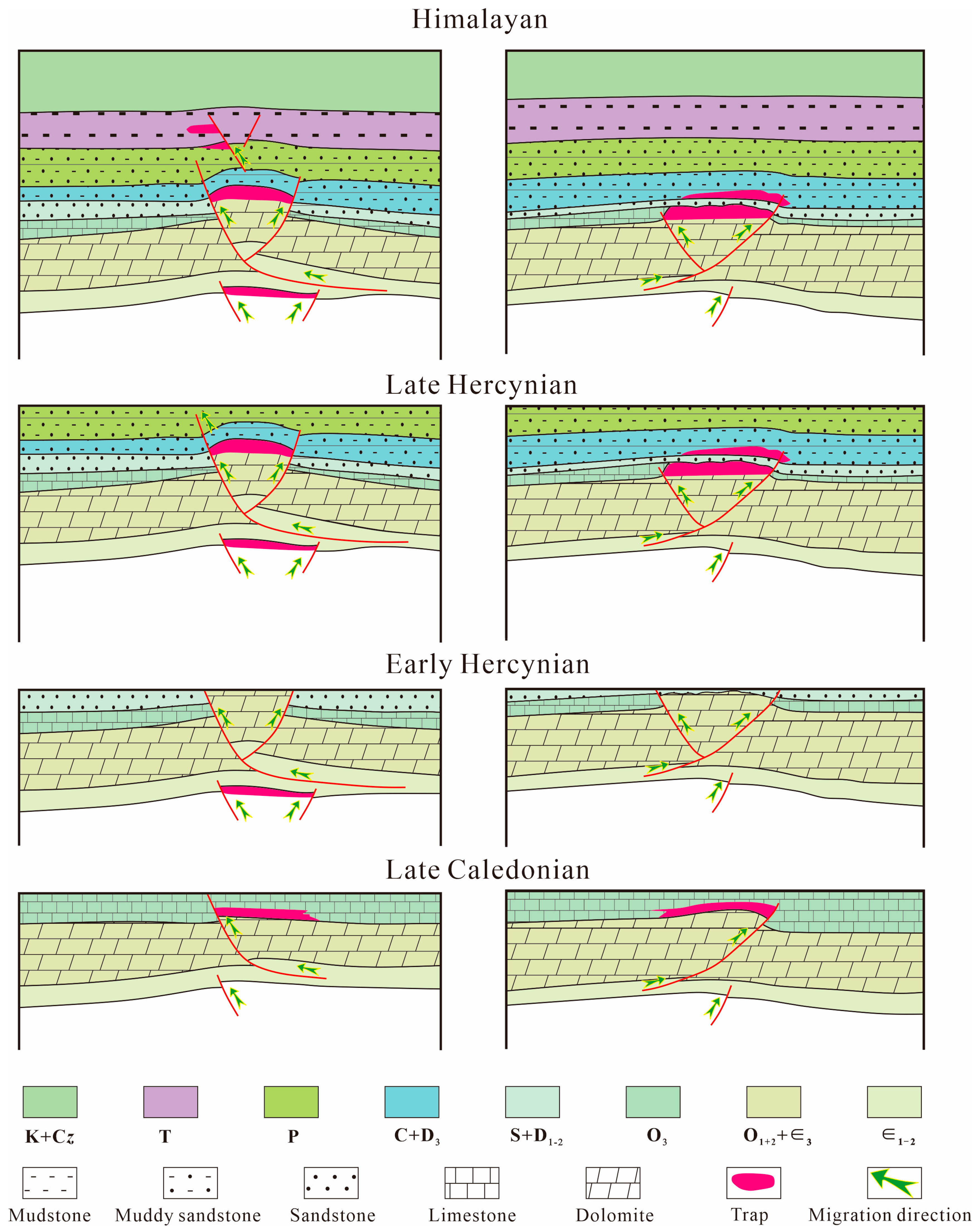
Based on previous studies [46,47], the hydrocarbon accumulation in the Tazhong area can be divided into four stages: the Late Caledonian, the Early Hercynian, the Late Hercynian, and the Himalayan. Considering the basic conditions and stages of hydrocarbon accumulation, and integrating the differential evolutionary characteristics of each structural segment, representative cross-sections of the structural segments were selected for the study of accumulation evolution. Here, the eastern segment and the central–western segment are selected for comparative analysis. As shown in Figure 8, during the Late Caledonian, the Tazhong No. 2 fault developed. Combined with previous analyses of the thermal evolution history of source rocks [46], it is inferred that hydrocarbons sourced from the Lower Ordovician source rocks migrated along thrust faults and ultimately accumulated within the Upper Ordovician Sangtamu Formation. The Early Hercynian was an important period of hydrocarbon charging for the Tazhong No. 2 fault zone but also a period of hydrocarbon destruction: the Silurian strata were eroded, causing hydrocarbon loss and resulting in the bitumen and heavy oil that are widespread in the Silurian [48]. By the Late Hercynian, the differential deformation among the various structural segments of Tazhong became pronounced. In the eastern segment, pre-existing thrust faults were reactivated, resulting in the development of growth strata within the Permian. These faults did not cut through the Carboniferous, and hydrocarbons that migrated along faults and unconformities may have accumulated and been preserved in the Carboniferous. In the central–western segment, thrust faults cut into the Permian, which may have led to the leakage of hydrocarbons that had migrated to shallow levels. In the western segment, traps related to Early Permian magmatic diapirism may have captured a certain amount of hydrocarbons. During the Himalayan period, the central part of the Tazhong No. 2 fault zone was active, whereas the eastern and western segments were essentially inactive; in the eastern and western segments, the traps formed earlier remained effective and continued to capture migrating hydrocarbons, whereas in the central part—such as the central–western segment—early thrust faults were reactivated, producing growth strata in the Cenozoic, and migrating hydrocarbons may have moved upward along the thrust faults and accumulated in related traps near the Mesozoic-developed faults.
During the Early Hercynian, the Middle–Lower Cambrian evaporites accumulated at the crests of the subsalt highs under compression and gravity. This salt tectonic deformation process may have improved local sealing conditions, making it possible for hydrocarbons to be entrapped in subsalt traps. However, in the western part of the Tazhong No. 2 structural belt, magmatic intrusion may have disrupted the evaporite cap rock and reduced the effectiveness of the subsalt traps.
In summary, the differential evolution of the Tazhong No. 2 fault zone has given rise to differential hydrocarbon enrichment. Overall, this study concludes that the magmatic-diapir-related traps in the western segment, the Mesozoic fault–lithologic traps in the central part, and the drape traps in the eastern segment are favorable exploration targets; subsalt structural traps should also receive exploration attention; and karst-type traps are likewise exploration targets that cannot be overlooked.

6. Conclusions

  • The Tazhong No. 2 fault zone can be divided into four segments, with adjacent structural segments bounded by NE-trending strike-slip faults. Each segment exhibits distinct geometric characteristics, and magmatic intrusion is intense in the western part.
  • The individual segments of the Tazhong No. 2 fault zone underwent different evolutionary processes. Faulting in the central part lasted for a long time, whereas faulting at both ends was of short duration; the eastern segment experienced intense deformation during the Caledonian–Early Hercynian, while the two central segments were reactivated as thrust faults during the Himalayan.
  • The segmented and layered structural deformation of the Tazhong No. 2 fault zone is controlled by factors such as the basement architecture, the Middle–Lower Cambrian detachment layer, and regional tectonic events.
  • In the western segment of the Tazhong No. 2 fault zone, favorable traps can form owing to shielding by igneous rocks; minor faults in the Mesozoic can form fault–lithologic traps; karst-type hydrocarbon reservoirs should be regarded as exploration targets that cannot be overlooked; and the exploration of subsalt structural traps also warrants attention.

Author Contributions

Writing—original draft, H.X.; project administration and conceptualization, F.Y.; visualization, H.C.; methodology, Z.Z.; writing—review and editing, C.H. All authors have read and agreed to the published version of the manuscript.

Funding

This research received no external funding.

Data Availability Statement

The original contributions presented in this study are included in the article. Further inquiries can be directed to the corresponding author.

Conflicts of Interest

Author Fan Yang and Honggang Cheng was employed by the company PetroChina Research Institute of Petroleum Exploration and Development. The remaining authors declare that the research was conducted in the absence of any commercial or financial relationships that could be construed as a potential conflict of interest.

References

  1. Xiong, C.; Shen, C.G.; Zhao, X.X.; Zhao, L.F.; Li, S.Q.; Zhou, J.; Pan, T.J. Segmentation of strike-slip faults and its controls on hydrocarbon accumulation in Tarim basin: A case study of FI17 strike-slip fault zone. Xinjiang Pet. Geol. 2024, 45, 417–424. [Google Scholar] [CrossRef]
  2. Wu, G.H.; Yang, H.J.; He, S.; Shu, J.C.; Xing, L.; Jing, B. Effects of structural segmentation and faulting on carbonate reservoir properties: A case study from the Central Uplift of the Tarim Basin, China. Mar. Pet. Geol. 2016, 71, 183–197. [Google Scholar] [CrossRef] [Scilit]
  3. Song, Z.H.; Tang, L.J.; Liu, C. Variations of thick-skinned deformation along tumuxiuke thrust in Bachu uplift of Tarim Basin, northwestern China. J. Struct. Geol. 2021, 144, 104277. [Google Scholar] [CrossRef] [Scilit]
  4. Song, G.H.; Wang, M.M.; Jiang, D.Q.; Chen, Z.X.; Yan, B.; Feng, W. Along-strike structural linkage and interaction in an active thrust fault system: A case study from the western Sichuan foreland basin, China. Basin Res. 2021, 33, 210–226. [Google Scholar] [CrossRef] [Scilit]
  5. Peacock, D.C.P.; Nixon, C.W.; Rotevatn, A.; Sanderson, D.J.; Zuluaga, L.F. Interacting faults. J. Struct. Geol. 2017, 97, 1–22. [Google Scholar] [CrossRef] [Scilit]
  6. Tian, F.L.; He, D.F.; Chen, J.J.; Mao, D.F. Northern and Central Segments of Shunbei No.5 Strike-Slip Fault Zone in Tarim Basin: Structural Characteristics and Spatio-Temporal Evolution Process. Earth Sci. 2023, 48, 2117–2135. [Google Scholar] [CrossRef]
  7. Fu, X.F.; Feng, J.; Wang, H.X.; Deng, S.; Ma, Q.Y.; Lan, M.J.; Yi, Z.J. Sandbox Physical Simulation on “Different Period-Different Direction” Deformation Process of Strike-Slip Faults: A Case Study of Northern Segment of Shunbei No. 5 Fault in Tarim Basin. Earth Sci. 2023, 48, 2104–2116. [Google Scholar] [CrossRef]
  8. Song, X.G.; Chen, S.; Xie, Z.; Kang, P.F.; Li, T.; Yang, M.H.; Liang, X.X.; Peng, Z.J.; Shi, X.K. Strike-slip faults and hydrocarbon accumulation in the eastern part of Fuman oilfield, Tarim Basin. Oil Gas Geol. 2023, 44, 335–349. [Google Scholar] [CrossRef]
  9. Wu, C.; Xu, W.Q.; Mo, T.; Wang, W.; Dong, R.X.; He, W.H.; Hu, C.L.; Gao, Z.H.; Gu, C.L.; Ying, H.W. Subsalt Multi-detachment Deformation in the Eastern Segment of the Kelasu Structural Belt of the Kuqa Depression: Insights from Numerical Simulations. Geol. J. China Univ. 2025, 31, 405–417. [Google Scholar] [CrossRef]
  10. Li, C.S.; Yin, H.W.; Wu, Z.Y.; Zhou, P.; Wang, W.; Ren, R.; Guan, S.W.; Li, X.Y.; Luo, H.Y.; Jia, D. Effects of salt thickness on the structural deformation of foreland fold-and-thrust belt in the Kuqa Depression, Tarim Basin: Insights from discrete element models. Front. Earth Sci. 2021, 9, 655173. [Google Scholar] [CrossRef] [Scilit]
  11. Zhu, Y.Z.; Li, C.X.; Jiang, X.Y.; Zhao, Y.B.; Tulujun, G. Differential salt-related structural deformation in the Eastern segment of the Qiulitage fold and thrust belt, Kuqa Foreland Basin: Evidences from seismic interpretation and numerical simulation analysis. J. Struct. Geol. 2025, 194, 105372. [Google Scholar] [CrossRef] [Scilit]
  12. Tang, L.J.; Qi, L.X.; Qiu, H.J.; Yun, L.; Li, M.; Xie, D.Q.; Yang, D.Y.; Wan, G.M. Poly-phase differential fault movement and hydrocarbon accumulation of the Tarim Basin, NW China. Acta Petrol. Sin. 2012, 28, 2569–2583. [Google Scholar]
  13. Wu, G.H.; Yang, H.J.; Qu, T.L.; Li, H.W.; Luo, C.S.; Li, B.L. The fault system characteristics and its controlling roles on marine carbonate hydrocarbon in the Central uplift, Tarim basin. Acta Petrol. Sin. 2012, 28, 793–805. [Google Scholar]
  14. Jiang, T.W.; Han, J.F.; Wu, G.H.; Yu, H.F.; Su, Z.; Xiong, C.; Chen, J.; Zhang, H.F. Differences and controlling factors of composite hydrocarbon accumulations in the Tazhong uplift, Tarim Basin, NW China. Pet. Explor. Dev. 2020, 47, 229–241. [Google Scholar] [CrossRef] [Scilit]
  15. Fang, Q.F.; Yao, Q.Z.; Qu, Y.Q.; Jiang, Y.L.; Li, H.Z.; Dai, D.D.; Fan, S.; Zhu, W.P.; Yang, L.S.; Wang, X.X.; et al. Variability and Main Controlling Factors of Hydrocarbon Migration and Accumulation in the Lower Paleozoic Carbonate Rocks of the Tazhong Uplift, the Tarim Basin, Northwest China. Geofluids 2021, 2021, 6693658. [Google Scholar] [CrossRef] [Scilit]
  16. Han, J.F.; Su, Z.; Chen, L.X.; Guo, D.S.; Zhang, Y.T.; Ji, Y.G.; Zhang, H.F.; Yuan, J.Y. Reservoir-controlling and accumulation-controlling of strike-slip faults and exploration potential in the platform of Tarim Basin. Acta Pet. Sin. 2019, 40, 1296–1310. [Google Scholar] [CrossRef]
  17. Wang, Q.H.; Yang, H.J.; Wang, R.J.; Li, S.Y.; Deng, X.L.; Li, D.; Chang, L.J.; Wan, X.G.; Zhang, Y.T. Discovery and exploration technology of fault-controlled large oil and gas fields of ultra-deep formation in strike slip fault zone in Tarim Basin. China Pet. Explor. 2021, 26, 58–71. [Google Scholar] [CrossRef]
  18. Yang, H.J.; Deng, X.L.; Zhang, Y.T.; Xie, Z.; Li, Y.; Li, S.Y.; Zhang, H.Z.; Zhu, Y.F.; Chen, Y.Q. Great discovery and its significance of exploration for Ordovician ultra-deep fault-controlled carbonate reservoirs of Well Manshen 1 in Tarim Basin. China Pet. Explor. 2020, 25, 13–23. [Google Scholar]
  19. Deng, X.L.; Chen, J.J.; Cao, P.; Zhang, Y.T.; Luo, X.; Chang, S.Y.; Shen, J.L.; Du, Y.F.; Wang, M.X. Segmentation and lateral growth of intracratonic strike-slip faults in the northern Tarim Basin, NW China: Influences on Ordovician fault-controlled carbonate reservoirs. Front. Earth Sci. 2023, 11, 1255162. [Google Scholar] [CrossRef] [Scilit]
  20. Lin, B.; Zhang, X.; Kuang, A.P.; Yun, L.; Liu, J.; Li, Z.J.; Cao, Z.C.; Xu, X.C.; Huang, C. Structural deformation characteristics of strike-slip faults in the Tarim Basin and their hydrocarbon significance: A case study of No.1 fault and No.5 fault in shunbei area. Acta Pet. Sin. 2021, 42, 906–923. [Google Scholar] [CrossRef]
  21. Luo, C.M.; Liang, X.X.; Huang, S.Y.; Neng, Y.; Zhang, W.; Chen, S.; Cao, S.J. Three-layer structure model of strike-slip faults in the Tazhong Uplift and its formation mechanism. Oil Gas Geol. 2022, 43, 118–131. [Google Scholar] [CrossRef]
  22. Tian, J.; Wang, Q.H.; Yang, H.J.; Li, Y. Petroleum Exploration History and Enlightenment in Tarim Basin. Xinjiang Pet. Geol. 2021, 42, 272–282. [Google Scholar] [CrossRef]
  23. Han, J.F.; Zhang, H.Z.; Yu, H.F.; Ji, Y.G.; Sun, C.H.; Han, J.; Dong, R.X. Hydrocarbon accumulation characteristic and exploration on large marine carbonate condensate field in Tazhong Uplift. Acta Petrol. Sin. 2012, 28, 769–782. [Google Scholar]
  24. Neng, Y.; Li, Y.; Qi, J.F.; Ma, X.; Zuo, L.; Chen, P. Deformation styles and multi-stage evolution history of a large intraplate strike-slip fault system in a Paleozoic superimposed basin: A case study from the Tarim Basin, NW China. Front. Earth Sci. 2022, 10, 837354. [Google Scholar] [CrossRef] [Scilit]
  25. Dong, K.L.; Tang, D.Q.; Sha, X.G.; Jiang, Z.Z.; Luo, S.H. Structural characteristics and evolution of NW thrust fault zone in the central western region of the Tazhong Area. Complex Hydrocarb. Reserv. 2025, 18, 302–310. [Google Scholar] [CrossRef]
  26. Neng, Y.; Yang, H.J.; Deng, X.L. Structural patterns of fault damage zones in carbonate rocks and their influences on petroleum accumulation in Tazhong Paleo-uplift, Tarim Basin, NW China. Pet. Explor. Dev. 2018, 45, 43–54. [Google Scholar] [CrossRef] [Scilit]
  27. Li, C.X.; Wang, X.F.; Li, B.L.; He, D.F. Paleozoic fault systems of the Tazhong uplift, Tarim Basin, China. Mar. Pet. Geol. 2013, 39, 48–58. [Google Scholar] [CrossRef] [Scilit]
  28. Geng, F.; Yi, Z.J.; Hao, J.L.; Sha, X.G.; Wang, H.X.; Feng, C.; Duan, H.L. Development Characteristics, Evolution and Formation Mechanism of Luoxi Fault in Maigaiti Slope, Tarim Basin. Earth Sci. 2023, 48, 2087–2103. [Google Scholar] [CrossRef]
  29. Chen, S.; Zhang, Y.T.; Xie, Z.; Song, X.G.; Liang, X.X. Multi-stages of Paleozoic deformation of the fault system in the Tazhong Uplift, Tarim Basin, NW China: Implications for hydrocarbon accumulation. J. Asian Earth Sci. 2024, 265, 106086. [Google Scholar] [CrossRef] [Scilit]
  30. Shen, Y.M.; Li, Y.; Li, M.; Liu, Y.F.; Li, Q.J.; Hu, T.P.; Dong, L.S. A Large Kink-Band: Tectonic Controlling Factor for the Ordovician Sediments in the Tazhong Oilfield. J. Stratigr. 2013, 37, 297–302. [Google Scholar] [CrossRef]
  31. Yi, Z.J.; Jiang, H.B.; Wang, H.X.; Feng, J.; Ma, J.H.; Song, X.Q.; Ding, Y.F.; Ji, W.L. Geometric characte ristics and formation mechanism of the Zhongliang 1 fault in the Tazhong Uplift, Tarim Basin. Chin. J. Geol. 2025, 60, 1710–1726. [Google Scholar] [CrossRef]
  32. Hu, D.S. Research on the Main Fault System and Their Implication to Petroleum Geology in Tazhong Uplift Area, Tarim Basin. Master’s Thesis, China University of Geosciences, Wuhan, China, 2010. [Google Scholar]
  33. Chen, Y.Q.; Pan, B.; Yang, G.; Chen, B.; Yi, Y.; Tian, H.N. Cambrian Chronostratigraphy, Sequence Stratigraphy, and Sedimentary Evolution of the Tarim Craton. J. Stratigr. 2024, 48, 219–236. [Google Scholar] [CrossRef]
  34. Zhao, Z.J.; Pan, W.Q.; Zhang, L.J.; Deng, S.H.; Huang, Z.B. Sequence Stratigraphy in the Ordovician in the Tarim Basin. Geotecton. Metallog. 2009, 33, 175–188. [Google Scholar] [CrossRef]
  35. Zhou, Z.Y. (Ed.) Stratigraphy of the Tarim Basin; Science Press: Beijing, China, 2001. [Google Scholar]
  36. Zhang, Z.P.; Wang, L.Y.; Deng, S.; Wei, H.D.; Zhang, J.B. Kinematic characteristics and genesis analysis of segmental deformation in Tazhong No. 1 structural belt, Tarim Basin. Geol. Rev. 2020, 66, 881–892. [Google Scholar] [CrossRef]
  37. Chen, X.; Dong, Y.W.; Hao, G.L. Magmatic Activities and Their Influences on Hydrocarbon Accumulation in the Early Permian, Central Tarim Basin. Geol. Sci. Technol. Inf. 2010, 29, 78–83. [Google Scholar]
  38. Li, M.; Guo, J.; Tang, L.J.; Liu, J.L.; Pang, S.Y. Differential Deformation Characteristics and Control Mechanism of Lower Paleozoic Fault in Tazhong Uplift. Sci. Technol. Eng. 2017, 17, 15–25. [Google Scholar]
  39. Wu, G.H.; Chen, X.; Ma, B.S.; Chen, Y.Q.; Tian, W.Z.; Huang, S.Y.; Feng, X.J. The tectonic environments of the Late Neoproterozoic-Early Paleozoic and its tectono-sedimentary response in the Tarim Basin. Acta Petrol. Sin. 2021, 37, 2431–2441. [Google Scholar] [CrossRef] [Scilit]
  40. Jiang, Z.Z.; Tang, D.Q.; Shu, X.G.; Shen, X.C.; Luo, S.H.; Dong, K.L.; Guzailinuer, A.; Wang, W.L.; Wu, L. Structure and evolution of faults in central and Northern Parts of Tazhong Uplift, Tarim Basin. Bull. Geol. Sci. Technol. 2024, 43, 120–132. [Google Scholar] [CrossRef]
  41. Li, K.Y.; Neng, Y.; Huang, S.Y.; Duan, Y.J.; Hou, X.X.; Hu, J.N.; Fu, Y.H.; Jiang, S. Distribution characteristics and genesis of unconformity surfaces from Late Ordovician to Jurassic in Tarim Basin. Sediment. Geol. Tethyan Geol. 2024, 44, 351–368. [Google Scholar] [CrossRef]
  42. Chen, L.X.; Jia, C.Z.; Wu, G.H.; Huang, S.Y.; Yang, S.; Chen, Y.Q.; Su, Z. Basement Architecture and Evolution of Neoproterozoic Tarim Rift Basin. Earth Sci. 2024, 49, 3445–3458. [Google Scholar] [CrossRef] [Scilit]
  43. Fang, Q.; Fang, T.L.; Li, Q.P.; Tu, Y.; Zhang, Y.; Yuan, Y.X. Sedimentary characteristics and development model of Cambrian gypsum-salt rocks, Tarim Basin. Pet. Geol. 2021, 43, 217–226. [Google Scholar] [CrossRef]
  44. Wang, Z.H.; Ding, W.M.; Li, J.; Hao, C.G.; Liu, H.; Li, T.; Dong, L. Paleoenvironment Interpretation of Early Cambrian Yurtus Formation, Tarim Basin, and Its Mechanism for Organic Carbon Accumulation. Acta Sci. Nat. Univ. Pekin. 2020, 56, 667–678. [Google Scholar] [CrossRef]
  45. Zhang, K.; Pan, W.Q.; Su, J.; Zhang, M. Distribution and hydrocarbon generation potential of the Nanhua-Cambrian source rocks in Tarim Basin. China Pet. Explor. 2022, 27, 121–134. [Google Scholar] [CrossRef]
  46. Xiong, C.; Wang, P.; Liu, X.Y.; Wang, W.; Zhao, X.X.; Sun, C. Geological characteristics and enrichment model of Ordovician oil and gas in Tazhong Uplift. Lithol. Reserv. 2025, 37, 53–67. [Google Scholar] [CrossRef]
  47. Zhao, X.X.; Li, B.; Wu, G.H.; Han, J.F.; Guan, B.Z.; Shen, C.G. Genesis and enrichment model of Ordovician multi-phase oil and gas reservoirs in Tazhong III block, Tarim Basin. Nat. Gas. Geosci. 2022, 33, 36–48. [Google Scholar] [CrossRef]
  48. Yang, H.J.; Han, J.F.; Chen, L.X.; Wu, G.H.; Ji, Y.G. Characteristics and patterns of complex hydrocarbon accumulation in the Lower Paleozoic carbonate rocks of the Tazhong Palaeouplift. Oil Gas Geol. 2007, 28, 784–790. [Google Scholar] [CrossRef]
Figure 1. Location map of the study area: (a) Regional tectonic unit map; (b) map of the major fault systems of the Tazhong uplift.
Processes 14 02754 g001
Figure 2. Integrated stratigraphic column of the Cambrian-Cretaceous strata in the Tazhong area (modified from Ref. [31]).
Processes 14 02754 g002
Figure 3. Typical anticlinal structure profile for the study area.
Processes 14 02754 g003
Figure 4. Research Flowchart of the Tazhong No. 2 Fault Zone.
Processes 14 02754 g004
Figure 5. Fault systems of the major periods in the Tazhong area (modified from Ref. [25]).
Processes 14 02754 g005
Figure 6. Representative seismic profiles of the Tazhong No. 2 fault zone (location is shown in Figure 1b): (a) Representative seismic profile of the western segment; (b) representative seismic profile of the west-central segment; (c) representative seismic profile of the east-central segment; (d) representative seismic profile of the eastern segment.
Processes 14 02754 g006
Figure 7. Trap-style characteristics of each segment of the Tazhong No. 2 fault zone (location is shown in Figure 1b): (a) Typical trap-style of the western segment; (b) Typical trap-style of the west-central segment; (c) Typical-trap style of the east-central segment; (d) Typical trap-style of the eastern segment.
Processes 14 02754 g007
Figure 8. Differential hydrocarbon accumulation–evolution models of the west-central and eastern segments of the Tazhong No. 2 fault zone.
Processes 14 02754 g008
Disclaimer/Publisher’s Note: The statements, opinions and data contained in all publications are solely those of the individual author(s) and contributor(s) and not of MDPI and/or the editor(s). MDPI and/or the editor(s) disclaim responsibility for any injury to people or property resulting from any ideas, methods, instructions or products referred to in the content.