Article

Tectonic Evolution and Hydrocarbon Implications of Wedge Structures in the Central Northern Piedmont Zone, Turpan–Hami Basin

1
School of Earth Sciences, Northeast Petroleum University, Daqing 163318, China
2
Northwest Branch, PetroChina Research Institute of Petroleum Exploration and Development, Lanzhou 730020, China
3
School of Computer & Information Technology, Northeast Petroleum University, Daqing 163318, China
*
Author to whom correspondence should be addressed.
Processes 2025, 13(7), 2009; https://doi.org/10.3390/pr13072009
Submission received: 23 May 2025 / Revised: 19 June 2025 / Accepted: 23 June 2025 / Published: 25 June 2025

Abstract

In recent years, major breakthroughs have been achieved in oil and gas exploration within China’s complex thrust–fault zones in the western region, confirming their significant potential. The northern piedmont zone of the Turpan–Hami Basin, a classic thrust–fold belt formed by the Bogda Orogenic belt’s overthrusting, has seen the discovery of several Jurassic–Cretaceous hydrocarbon fields, yet exploration at its thrust-front margins remains relatively underdeveloped. This study focuses on the central piedmont segment at Qialekan and Kekeya, integrating 3D seismic data with fault-related folding theory and balanced cross-section restoration to systematically analyze the area’s tectonic evolution. We specifically examine the formation and modification of wedge structures and assess their petroleum geological significance. Our results indicate that the wedge bodies formed in the Late Jurassic, along with their subsequent basinward insertion, critically controlled the present-day structural framework. In the Qialekan area, wedge formation coincided with the main hydrocarbon expulsion phase of underlying Permian source rocks. Type I faults acted as effective migration pathways, while later tectonic reworking was limited, favoring for hydrocarbon preservation. In contrast, in the Kekeya area, wedge structures underwent intense modification by Type II faults, which pierced the wedge and facilitated vertical hydrocarbon migration, creating a mixed-source accumulation pattern. The findings of this study provide new theoretical insights and practical guidance for future exploration in the northern piedmont zone and also offer a valuable reference for hydrocarbon exploration in structurally similar foreland basins.

1. Introduction

In recent years, significant progress has been made in oil and gas exploration in the complex thrust–fold tectonic regions of western China [1,2]. The Bohai–Dabei trillion-cubic-meter gas zone in the Kelasu thrust belt of the Tarim Basin has been basically developed [3,4,5]. After the breakthrough of the high-yield oil and gas flow in Well GT-1 of the southern margin thrust belt of the Junggar Basin, high-yield industrial oil and gas flows have also been obtained in Well HT-1 and Well TW-1 [6,7]. In the northern piedmont zone of the Turpan–Hami Basin (hereinafter referred to as the piedmont zone), as a thrust–fold system controlled by the tectonic thrusting of the Bogda orogenic belt, several Jurassic–Cretaceous oil and gas fields have been discovered, but the progress in the middle and deep layers of the front of the thrust belt has been relatively slow [8,9]. Thrust–fold belts usually experience multiple phases of compression, resulting in complex tectonic overprinting [10,11]. Previous research has focused on the tectonic characteristics of the piedmont zone. Liu et al. (2011) analyzed the vertical zoning and horizontal division of the tectonic patterns of the piedmont zone [12]; Yang et al. (2016) discussed the characteristics of the reverse fault system in the piedmont zone and its relationship with oil and gas accumulation [13]; and Huang et al. (2020) studied the tectonic deformation patterns and mechanisms of the piedmont zone [14]. However, due to technical limitations such as the complexity of the middle and deep seismic reflection wavefields, low seismic data quality, and poor imaging effects, previous studies have mostly focused on theoretical analyses of present-day tectonic styles and deformation mechanisms. Systematic research on the tectonic evolution process of the piedmont zone, especially on the wedge-shaped structures that form during thrust deformation [1,15,16], has been relatively weak. Therefore, based on newly acquired 3D seismic data and grounded in fault–fold interaction theory [17,18,19] and petroleum geological theory [20,21,22], this study offers a systematic analysis of the tectonic evolution in the central piedmont zone. It emphasizes the formation and modification process of the wedge structures and their implications for hydrocarbon accumulation. The results of this study are intended to support future oil and gas exploration in the region and also serve as a reference for exploration in geologically similar foreland basins.

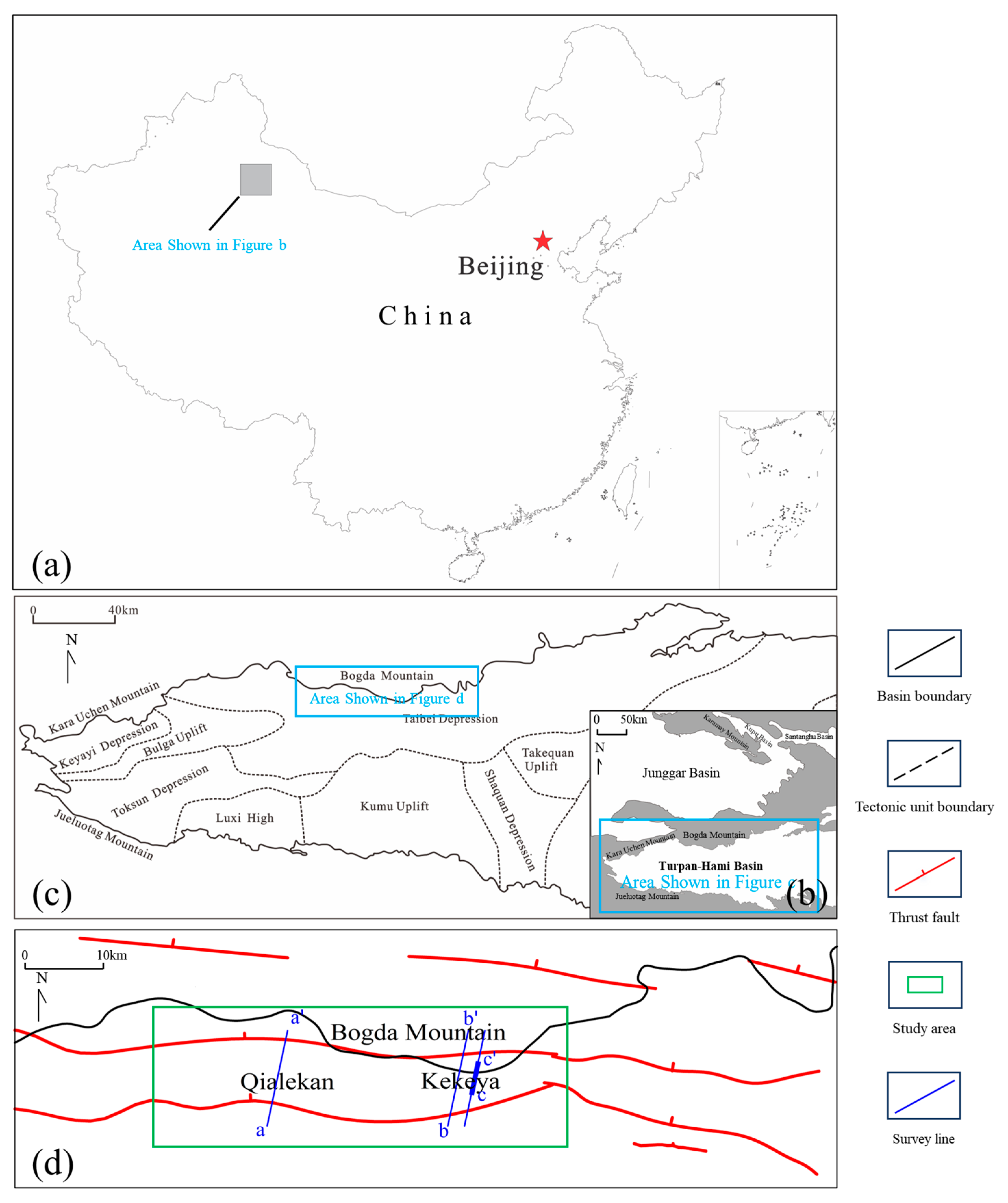
2. Geological Background

The Turpan–Hami Basin is located in the Xinjiang Uygur Autonomous Region in northwestern China and is one of the three major petroliferous basins in the region [23]. The piedmont zone is located in the basin–mountain transitional area between the northern margin of the Turpan–Hami Basin and the Bogda Mountains (Figure 1c). This region has undergone multiple episodes of compressional deformation during the Indosinian, Yanshanian, and Himalayan tectonic activity phases [24,25,26]. Among them, the central segments—namely, the Qialekan and Kekeya areas—are characterized by intense structural deformation and concentrated compressive stress, making them key target zones for hydrocarbon exploration breakthroughs in the northern piedmont belt [27]. The study area is underlain by high-quality Permian Taodonggou Formation source rocks and is adjacent to Jurassic Shuixigou Formation hydrocarbon-generating depressions. Both sets of source rocks have currently entered the mature stage, exhibiting strong hydrocarbon generation potential and sustained expulsion capability [9]. Lithological and seismic data reveal the widespread development of a 40–60 m thick coal-bearing formation within the Lower Jurassic, which constitutes an important regional detachment layer and seal (Figure 2). Vertically, this coal-bearing interval not only divides the study area into two structural layers with distinctly different deformation styles but also effectively separates the formation of two independent petroleum systems above and below [28].

3. Data and Methods

3.1. Data

Two key seismic profiles, a–a’ and b–b’, were selected for detailed analysis, providing essential data for the tectonic and sedimentary interpretation. These profiles were described based on their structural characteristics, fault types, and associated sedimentary layers.

3.2. Methods

Tectonic evolution characteristics were reconstructed by integrating the newly acquired seismic data and applying advanced geological modeling techniques. The methodology is outlined in the following steps:
First, seismic reflection data from the a–a’ and b–b’ profiles were analyzed to identify major structural features, including wedge-shaped bodies and associated fault systems. These features were used to map the geometry, lateral extent, and internal deformation of the wedge structures. Structural boundaries were interpreted based on seismic reflection terminations, fault offsets, and variations in reflector configuration.
Next, balanced cross-section restoration was carried out using the 2D-Move software 2012, applying the principle of volume conservation to restore the geometry of the deformed layers. This approach assumes a constant area of overlying strata during deformation, enabling prediction of detachment depths beneath thrust belts. By measuring fold lengths, the depth and geometry of shallow detachments can be estimated. Integrating bed length and area conservation principles, the method reconstructs pre-deformation geometries and quantifies shortening, thus ensuring structural validity and retro-deformability. Stratigraphic and structural changes were analyzed for each deformation stage—from the Late Triassic to the Paleogene—enabling the identification of key tectonic events and the calculation of shortening rates and deformation magnitudes at different stages of tectonic evolution.
Finally, fault activity and growth index were analyzed to assess the temporal and spatial variations in fault activity. The growth index (GI), which is the ratio of the hanging wall to footwall strata thickness, was calculated for the identified fault systems along the seismic profiles [30,31]. GI equal to 1 indicates that the fault was inactive during that period, whereas a value greater than 1 implies significant fault activity; the higher the value, the stronger the activity [32]. This analysis helped to determine the intensity of fault activity and its correlation with the formation and modification of the wedge-shaped structures. Additionally, the relationship between the tectonic evolution and hydrocarbon migration was investigated by analyzing the temporal match between the wedge-shaped structures’ formation and the expulsion of hydrocarbons from source rocks.

4. Results

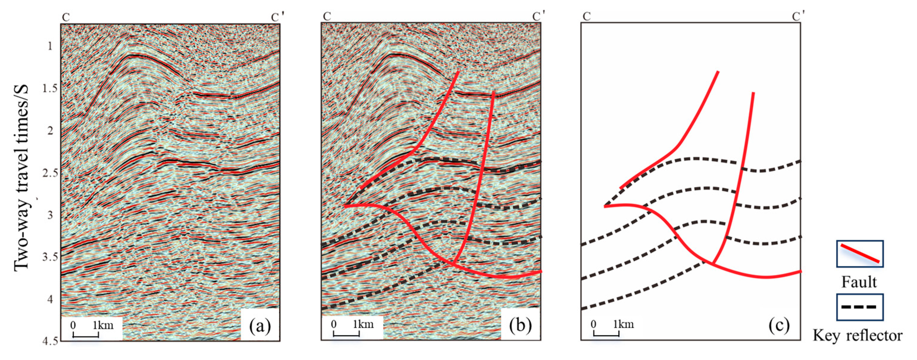
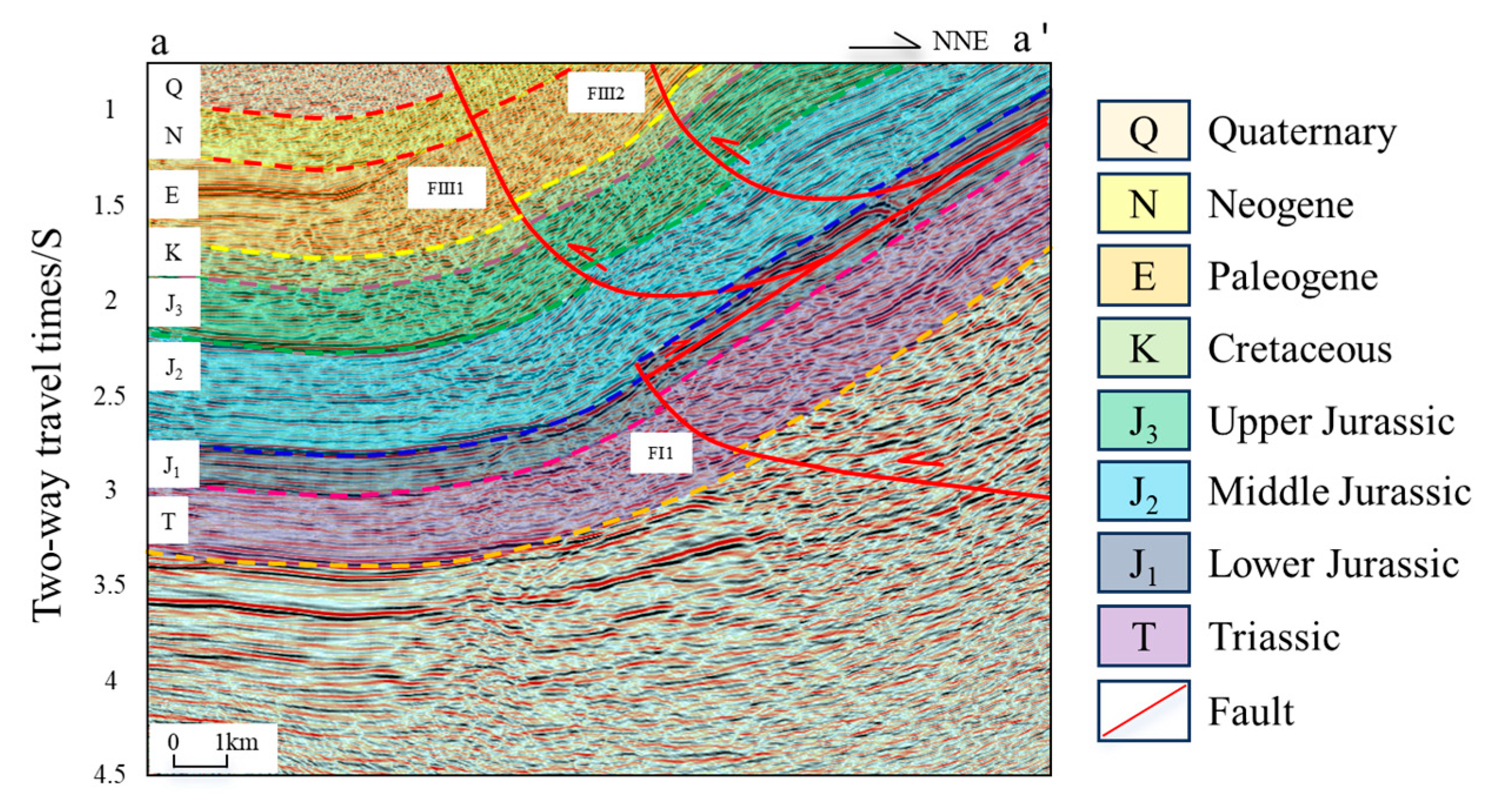
4.1. Tectonic Deformation Characteristics

The lower Jurassic coal-bearing strata, as previously mentioned, exhibit strong amplitude and good continuity in seismic profiles, making them easily identifiable. By tracing the reflection axes of these strata, it was observed that the overlying layers, particularly on the piedmont side, undergo significant tilting. The inflection point in these layers approximately coincides with the axial surface of the underlying strata, and their overall geometry fits the characteristics of wedge-shaped structures (Figure 3). The critical wedge theory, a key theoretical tool for analyzing the tectonic deformation characteristics in thrust–fold belts [29,33,34], suggests that the growth process of wedge-shaped structures, due to continuous compressive deformation, exhibits self-similarity [35,36,37]. Therefore, this study selected two high-quality seismic profiles (a–a’ and b–b’) along the west-to-east direction of the Bogda orogenic belt (Figure 1d), to apply the tectonic wedge model for a rational interpretation of the seismic profiles and to comprehensively analyze the tectonic deformation characteristics in the central segment of the piedmont zone.
Seismic profile a–a′ (Figure 4), which traverses the Qialekan area along the NNE direction, displays well-preserved wedge-shaped structures developed beneath the Lower Jurassic coal-bearing detachment layer. The wedge geometry is formed by the interaction of an interlayer detachment fault and the FI1 thrust fault, reflecting compressional deformation during the Jurassic period. The wedging of these structures causes the overlying strata to be uplifted, inducing the development of multiple reverse faults that terminate at the detachment layer. Additionally, reverse faults beneath the detachment layer typically exhibit gentler dip angles, indicating early-stage tectonic activity.
Seismic profile b–b′ (Figure 5), which traverses the Kekeya area along the NNE direction, reveals significant modification of the wedge-shaped structures. The wedge is composed of the FI2 fault and an interlayer detachment fault. From south to north, faults FII1, FII2, and FII3 are distributed sequentially, penetrating the detachment layer and extending into the middle and shallow strata. These faults exhibit strong activity and have substantially disrupted the integrity of the wedge structure. They generally display steep dips in their upper sections and gentler angles at greater depths. Additionally, some of these fault zones breach the surface and show evidence of erosion resulting from intense compressional thrusting.
Together, the two seismic profiles reveal the complex multi-phase, superimposed tectonic deformation characteristics in the central segment of the piedmont zone. Based on the fault styles and the fault penetration into different layers, the fault system in the study area can be classified into three types:
Type I Faults: These are reverse faults beneath the detachment layer and primarily serve to transmit and adjust the stress from deeper structural deformation. They represent the deformation products from the early stages of tectonic activity, before the formation of wedge-shaped structures.
Type II Faults: These are modified faults that penetrate the detachment layer. They exhibit steeper dip angles and intense tectonic activity, representing the main products of intense compression and superimposed deformation after the formation of the wedge-shaped structures.
Type III Faults: These are reverse faults that terminate at the detachment layer and are clearly controlled by the detachment surface. They represent the products of relatively strong tectonic compression after the formation of the wedge-shaped structures.

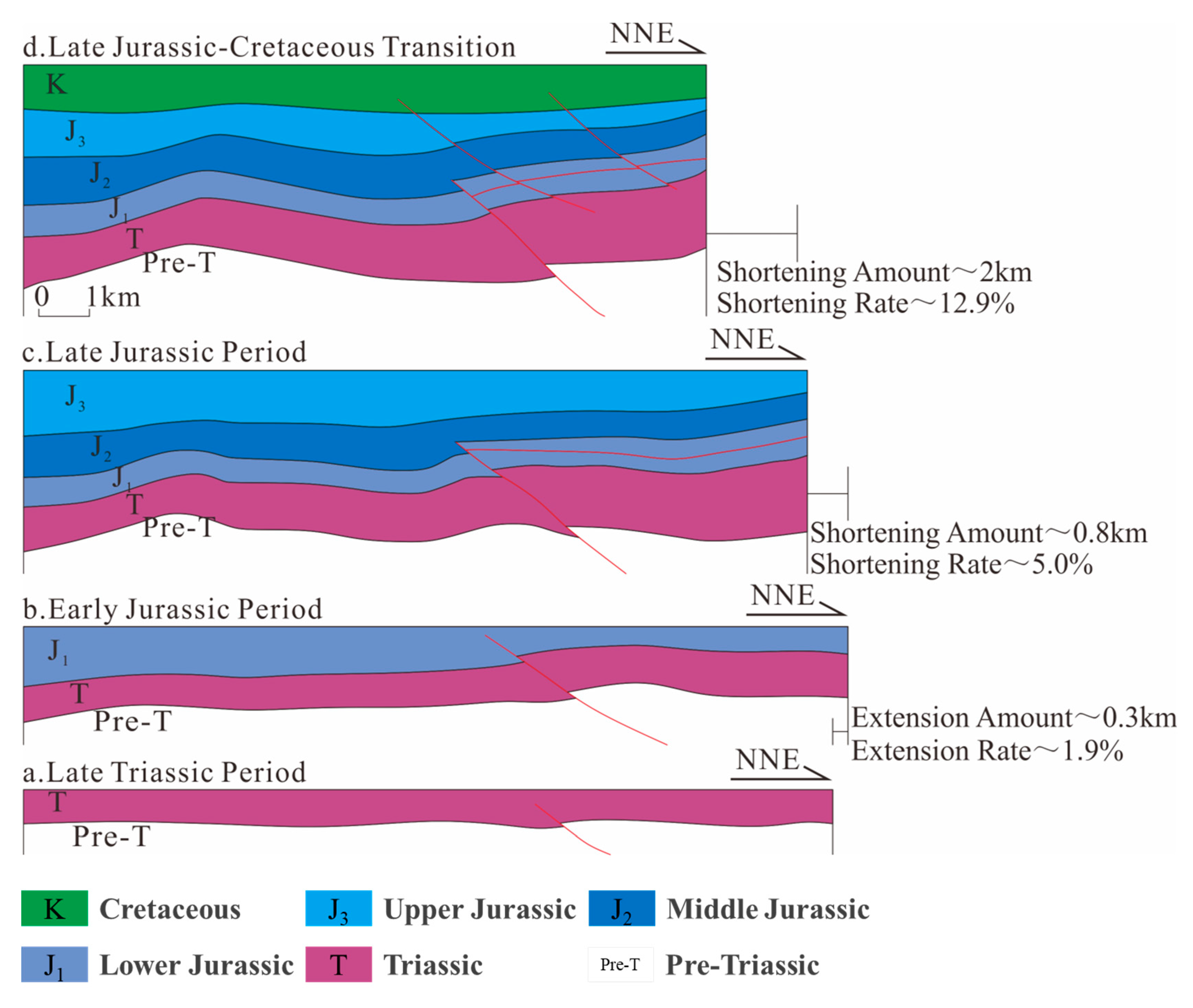
4.2. Tectonic Evolution Process

  • Late Triassic Period: Initial Compressive Deformation
Under the influence of plate compression during the Indosinian orogeny, intense tectonic stress led to the development of Type I thrust faults in the study area. The strata exhibit pronounced onlap and truncation-filling depositional characteristics under this compressional regime (Figure 6a and Figure 7a).
  • Early Jurassic Period: Transition from Compression to Extension
As the regional stress regime of the basin shifted from compression to extension, the study area experienced relatively weak tectonic deformation, marking a structurally stable period characterized by nearly horizontal sedimentation. During this stage, the a–a’ profile across the Qialekan area extended by approximately 0.2 km, with an estimated extension rate of ~1.3% (Figure 6b), while the b–b’ profile across the Kekeya area extended by about 0.3 km, corresponding to an extension rate of ~2% (Figure 7b).
  • Late Jurassic Period: Strong Compression and Thrusting
During the Early Yanshanian orogenic phase, the Bogda Mountains continued to thrust southward, inducing intense thrusting and nappe deformation within the study area. This led to interlayer detachment within the Lower Jurassic coal-bearing strata, forming detachment faults that, in combination with pre-existing Triassic thrust faults, generated wedge-shaped structural bodies. Subsequently, sustained strong compressional stress drove these wedges to progressively insert into the basin, producing a basal wedging effect. This not only caused uplift of the overlying strata in the central segment of the piedmont zone but also resulted in the continued deep burial of the underlying Permian source rocks beneath the wedge. During this period, the a–a’ profile across the Qialekan area experienced a shortening of approximately 0.5 km, corresponding to a shortening rate of ~3.3% (Figure 6c), while the b–b’ profile across the Kekeya area shortened by about 0.8 km, with a shortening rate of ~5.2% (Figure 7c).
  • Late Jurassic–Cretaceous Transition: Peak of Thrusting and Wedge Formation
Accompanied by the intense compressional stress resulting from the rapid uplift of the Bogda Mountains [38,39], the wedge-shaped structural body continued to propagate into the basin, forming a series of thrust–fold structures. During this wedge emplacement process, multiple Type III faults terminating at the detachment layer developed in the Qialekan area above the décollement, while in the Kekeya area, Type II faults formed and strongly dissected the wedge body, significantly disrupting its original structural integrity. In addition, the basal wedging effect not only uplifted the overlying strata in the central piedmont zone but also caused the continuous deep burial of the underlying Permian source rocks beneath the wedge. During this stage, the a–a’ profile across the Qialekan area experienced approximately 1.2 km of shortening, with a shortening rate of ~8.2% (Figure 6d), whereas the b–b’ profile across the Kekeya area shortened by about 2.0 km, corresponding to a shortening rate of ~13.8%, indicating intense compressional deformation (Figure 7d).
  • Paleogene Period: Final Adjustment and Structural Stabilization
During the Himalayan orogenic phase, the Bogda Mountains underwent renewed intense tectonic activity, leading to the final shaping of the structural framework in the study area.
  • Summary of Tectonic Evolution
Based on the above analysis, the formation of the wedge–shaped structural bodies and their sustained wedge insertion are key indicators of the tectonic evolution in the central piedmont zone. This study shows that the structural style began in the Late Triassic, underwent intense modification from the Late Jurassic to Cretaceous, and was finally reshaped and stabilized during the Paleogene. Crucially, variations in regional compressional stress in the Late Jurassic–Cretaceous transition determined whether the wedge structures were preserved.

5. Discussion

5.1. Analysis of Fault Activity

The aforementioned faults in the central segment of the piedmont belt have undergone multiple episodes of superimposed tectonic movements and reactivation throughout the prolonged geological history, resulting in distinct vertical growth patterns. The timing and intensity of fault activity are generally assessed using variations in the growth index [40,41].
Using faults FI1and FII1 identified in the two seismic profiles discussed earlier as examples, the variation patterns of the growth index are analyzed (Figure 8). Fault FI1 exhibits a growth index significantly greater than 1 during the Lower Jurassic depositional stage, indicating strong fault activity at that time. In contrast, growth index in other periods approach or equal 1, suggesting weak or nearly inactive fault movement during those stages. In the Kekeya area, Fault FII1 demonstrates relatively high growth indices during both the Cretaceous and Upper Jurassic depositional periods, with the highest values observed during the Cretaceous. This suggests that the fault was most active during the Cretaceous, followed by a moderately active phase in the Upper Jurassic.

5.2. Petroleum Geological Significance

The aforementioned tectonic evolution characteristics highlight that the wedge-shaped structural bodies formed by the combination of detachment faults and pre-existing thrust faults under strong compressional forces during the Late Jurassic were key in shaping the present-day structural configuration of the central segment of the northern piedmont zone. The relationship between this wedge emplacement process and hydrocarbon accumulation is mainly reflected in two aspects. First, the spatiotemporal coupling between wedge formation, fault activity, and source rock evolution significantly influenced hydrocarbon accumulation. Second, the subsequent modification of wedge structures impacted hydrocarbon migration and entrapment.
Specifically, in the Qialekan area, the formation period of the wedge-shaped structural body generally coincides with the main hydrocarbon generation and expulsion stage of the Permian source rocks [42]. During the wedge emplacement process, Type I faults exhibited intense activity (GI > 1), serving as effective conduits for vertically transporting deeply generated hydrocarbons into the interior of the wedge, where accumulation occurred. More importantly, during the post-Jurassic tectonic evolution, due to relatively weaker regional compressive stress compared with the Kekeya area, most of the newly formed thrust faults terminated at the coal-bearing detachment layer. As a result, the wedge-shaped structure remained largely intact without significant deformation or disruption, providing favorable conditions for hydrocarbon preservation. In contrast, the wedge-shaped structural body in the Kekeya area experienced intense modification after its initial formation. Its structural integrity was significantly compromised during later tectonic episodes. Growth index analysis further reveals that Type II faults, which developed after the end of the Jurassic, exhibited strong activity as indicated by high growth index. These faults penetrated the coal-bearing detachment layer and possessed strong vertical migration capacity, enabling hydrocarbons generated from Permian source rocks within the wedge body to migrate upward into strata above the detachment layer. Under the sealing effect of regional cap rocks, effective hydrocarbon accumulation was achieved. This migration–accumulation process is consistent with the understanding proposed by Hao et al. (2022), who, through geochemical experiments and oil–source correlation analysis, demonstrated that the Kekeya area exhibits characteristics of mixed-source oil accumulation [43]. As shown in Figure 9, biomarker ratios such as Pristane/Phytane (Pr/Ph) and Gammacerane/C30(H+M) are widely recognized as key indicators of the origin of organic matter, thereby serving as crucial parameters for identifying hydrocarbon sources in petroleum systems [44]. These results collectively support the validity of the inferred hydrocarbon migration and accumulation processes in both study areas.

5.3. Exploration Implications for Structurally Similar Foreland Basins

As previously discussed, wedge structures are critical components of thrust belts in foreland basins [45,46], and their subsequent modification has a significant impact on exploration target selection. When the formation of a wedge-shaped structural body coincides with the main hydrocarbon generation and expulsion period of the source rock, substantial quantities of hydrocarbons may accumulate within the wedge. Whether these hydrocarbons can be preserved depends largely on whether the wedge structure has undergone later fault-related modification. If it remains well preserved, the wedge structure undoubtedly represents an optimal exploration target. Conversely, if it has been significantly modified in later stages, the shallower strata are likely to become the primary exploration focus. Importantly, this theoretical understanding has been validated by comparison with laboratory results, confirming that it is consistent with the geological reality of the northern piedmont zone of the Turpan–Hami Basin. Therefore, it offers effective guidance for exploration in structurally similar regions.

6. Conclusions

A regionally extensive Lower Jurassic coal-bearing detachment layer developed in the central segment of the northern piedmont zone in the Turpan–Hami Basin. During intense Late Jurassic compression, this layer underwent inter-bed sliding, forming detachment faults that, together with underlying pre-existing thrust faults, generated wedge-shaped structural bodies. Under continued compressional stress, these wedges were thrust basinward, and multiple reverse faults developed above the detachment layer, resulting in a complex thrust–fold structural system.
In the Qialekan area of the central piedmont zone—where compressional intensity was relatively weaker than in the Kekeya area—the wedge structures are better preserved. Their formation coincides with the main hydrocarbon expulsion stage of the underlying Permian source rocks. During wedge formation, the inherited thrust faults were highly active (GI > 1), enabling efficient migration and accumulation of hydrocarbons within the wedge. In contrast, in the Kekeya area, strong subsequent tectonic reworking significantly modified the wedge structures; reverse faults penetrated the detachment layer and transported hydrocarbons generated from Permian source rocks within the wedges upward, leading to their accumulation in strata above the coal-bearing detachment layer.

Author Contributions

Writing, Original draft, K.S.; Investigation, Formal Analysis, C.H.; Investigation, Resources, J.H.; Writing—Review, Z.L.; Project administration, B.H.; Application of statistical, S.Z.; Supervision, Z.M.; Supervision, H.Z.; Supervision, Y.S. All authors have read and agreed to the published version of the manuscript.

Funding

This research received no external funding.

Data Availability Statement

The raw data supporting the conclusions of this article will be made available by the authors on request.

Acknowledgments

Corresponding author Jiacheng Huang would like to express their sincere gratitude to Leng Huang from Wuzhou Medical College for her valuable assistance in the editing and refinement of this manuscript. Her professional input significantly enhanced the clarity and academic quality of the paper.

Conflicts of Interest

Author Bin Hao was employed by the company Northwest Branch, PetroChina Research Institute of Petroleum Exploration and Development. The remaining authors declare that the research was conducted in the absence of any commercial or financial relationships that could be construed as a potential conflict of interest. The company had no role in the design of the study; in the collection, analyses, or interpretation of data; in the writing of the manuscript, or in the decision to publish the results.

References

  1. Jia, C.Z.; Chen, Z.X.; Lei, Y.L.; Wang, L.N.; Ren, R.; Su, N.; Yang, G. Tectonic deformation mechanisms and structural models of fold-and-thrust belts in central and western China. Earth Sci. Front. 2022, 29, 156–174. [Google Scholar]
  2. Chang, D.S.; Wang, G.Z.; Wen, T.M.; Li, D.S.; Hu, S.H.; Li, K.; Liu, D.M. Seismic exploration technologies and future directions for hydrocarbon detection in China’s foreland thrust belts. Acta Petrolei Sinica 2024, 45, 276–294. [Google Scholar]
  3. Yang, X.W.; Wang, Q.H.; Li, Y.; Lv, X.Y.; Xie, H.W.; Wu, C.; Wang, C.L.; Wang, X.; Mo, T.; Wang, R. Formation mechanism of the Bozi-Dabei trillion-cubic-meter gas area in the Kuqa foreland thrust belt. Earth Sci. Front. 2022, 29, 175–187. [Google Scholar]
  4. Yang, K.; Qi, J.; Shen, F.; Sun, T.; Duan, Z.; Cui, M.; Lv, J. Formation Mechanism of Salt Piercement Structures in a Compressive Environment: An Example from the Kuqa Depression, Western China. J. Struct. Geol. 2024, 178, 105005. [Google Scholar] [CrossRef]
  5. Wen, C.; Wang, Z. Formation and Evolution of Multi-Genetic Overpressure and Its Effect on Hydrocarbon Accumulation in the Dabei Area, Kuqa Depression, Tarim Basin, China. Energies 2024, 17, 6263. [Google Scholar] [CrossRef]
  6. Du, J.H.; Zhi, D.M.; Li, J.Z.; Yang, D.S.; Tang, Y.; Qi, X.F.; Xiao, L.X.; Wei, L.Y. Major discovery of the Gaotan-1 well and exploration prospects in the lower assemblage of the southern Junggar Basin. Pet. Explor. Dev. 2019, 46, 205–215. [Google Scholar] [CrossRef]
  7. Pang, Z.C.; Ji, D.S.; Liu, M.; Shi, L.; Li, J.; Gao, Z.Y.; Wei, L.Y.; Wang, J.; Ding, Y.C. Hydrocarbon accumulation conditions and exploration potential of the Jurassic–Cretaceous in the southern Junggar Basin thrust belt. Acta Petrolei Sinica 2023, 44, 1258–1273. [Google Scholar]
  8. Wu, Q.P.; Yang, Z.L.; Yao, J.; Yuan, C.; Zhang, J. Hydrocarbon accumulation conditions and exploration directions of the Lower–Middle Jurassic Shuixigou Formation in the northern Turpan-Hami Basin. Lithol. Reserv. 2021, 33, 1–11. [Google Scholar]
  9. Zhi, D.M.; Li, J.Z.; Chen, X.; Yang, F.; Liu, J.T.; Gou, H.G.; Zhang, H.; Lin, L.; Li, B.; Sun, Y.F.; et al. New exploration domains, types, and resource potential of the Turpan-Hami Basin. Acta Pet. Sin. 2023, 44, 2122–2140. [Google Scholar]
  10. Ma, D.L.; He, D.F.; Yuan, J.Y.; Zhang, H.Q.; Pan, S.X.; Wang, H.B.; Wang, Y.J.; Wei, C.R.; Guo, J.J. Deep geological structure and hydrocarbon-controlling roles in the southern Junggar Basin foreland thrust belt: A case study of the Huerguosi–Manas–Tugulu fold-and-thrust belt. Earth Sci. Front. 2019, 26, 165–177. [Google Scholar]
  11. Liang, H.; Wen, L.; Ran, Q.; Han, S.; Liu, R.; Chen, K.; Di, G.D.; Chen, X.; Pei, Y.W. Tectonic evolution and petroleum geological significance of the northern Longmen-shan foreland. Pet. Explor. Dev. 2022, 49, 478–490. [Google Scholar]
  12. Liu, B.; Huang, Z.L.; Tu, X.X.; Zhang, J.W.; Mu, K.X. Structural styles and hydrocarbon accumulation in the northern piedmont of the Taibei Sag, Turpan-Hami Basin. Petroleum Explor. Dev. 2011, 38, 152–158. [Google Scholar] [CrossRef]
  13. Yang, Z.L.; Wu, Q.P.; Huang, Y.F.; Huang, X.P. Hydrocarbon accumulation model and exploration direction in the northern thrust belt of the Turpan-Hami Basin. Nat. Gas Geosci. 2016, 27, 974–981. [Google Scholar]
  14. Huang, D.F.; Jiang, M.L.; Shao, M.J.; Lin, L.; Cheng, T.; Li, C.M.; Liu, J.T. Structural styles and evolution characteristics of the northern piedmont zone of the Turpan-Hami Basin. Xinjiang Pet. Geol. 2020, 41, 651–657. [Google Scholar]
  15. Yang, G.; Chen, Z.X.; Wang, X.B. Superimposed wedge structural model of Mingshanxia, eastern Sichuan. Geol. Rev. 2021, 67, 901–917. [Google Scholar]
  16. Zhou, C.; He, J.K.; Su, H.; Wang, W.M.; Wang, X.G.; Zhao, Y.J.; Jiang, Y. Discrete element modeling of distal deformation propagation in thrust wedges and implications for early deformation on the northern Tibetan and Iranian Plateaus. J. Struct. Geol. 2024, 184, 105150. [Google Scholar] [CrossRef]
  17. Henaish, A.; Kharbish, S.; Abdelhady, M.; Khedr, F. Fault Interactions and Role of Preexisting Structures on the Geometry of Conjugate Transfer Zones: Structural Insights from Cairo-Suez District, Egypt. Mar. Pet. Geol. 2025, 177, 107402. [Google Scholar] [CrossRef]
  18. Shalaby, A.; Sarhan, M.A. Origin of Two Different Deformation Styles via Active Folding Mechanisms of Inverted Abu El Gharadiq Basin, Western Desert, Egypt. J. Afr. Earth Sci. 2021, 183, 104331. [Google Scholar] [CrossRef]
  19. Cheng, G.; Jiang, B.; Li, M.; Li, F.; Zhu, M. Structural Evolution of Southern Sichuan Basin (South China) and Its Control Effects on Tectonic Fracture Distribution in Longmaxi Shale. J. Struct. Geol. 2021, 153, 104465. [Google Scholar] [CrossRef]
  20. Barbosa, G.S.; Garcia, G.G.; Pena dos Reis, R.P.B.; Garcia, A.J.V.; Barberes, G.d.A. Analysis of the Efficiency of Petroleum Systems in Fluvial Environments in the Rift Context of the South and North Atlantic: Brazil and Portugal. Geosciences 2023, 13, 239. [Google Scholar] [CrossRef]
  21. Barbosa, G.S.; Pena dos Reis, R.; Garcia, A.J.V.; Barberes, G.d.A.; Garcia, G.G. Petroleum Systems Analysis of Turbidite Reservoirs in Rift and Passive Margin Atlantic Basins (Brazil and Portugal). Energies 2022, 15, 8224. [Google Scholar] [CrossRef]
  22. Perrodon, A.; Masse, P. Subsidence, Sedimentation and Petroleum Systems. J. Pet. Geol. 1984, 7, 5–25. [Google Scholar] [CrossRef]
  23. Gong, D.; Cao, Z.; Ni, Y.; Jiao, L.; Yang, B.; Zhao, L. Origins of Jurassic Oil Reserves in the Turpan-Hami Basin, Northwest China: Evidence of Admixture from Source and Thermal Maturity. J. Pet. Sci. Eng. 2016, 146, 788–802. [Google Scholar] [CrossRef]
  24. Yuan, M.S.; Liang, S.J.; Yan, L.C. Petroleum Geology and Exploration Practice in the Turpan-Hami Basin; Petroleum Industry Press: Beijing, China, 2002; pp. 198–203. [Google Scholar]
  25. Xiao, D.S.; Chen, X.; Kang, J.L.; Chen, Y.H.; Liu, W.H.; Zhu, J.F.; Wei, Y.; Yang, Z.; Zhao, F.; Sun, Q.; et al. Control of Bogda Mountain tectonic evolution on hydrocarbon accumulation in the western Taibei Sag, Turpan-Hami Basin. J. Cent. South Univ. Sci. Technol. 2014, 45, 3877–3885. [Google Scholar]
  26. Watterson, J. Fault Dimensions, Displacements and Growth. Pure Appl. Geophys. 1986, 124, 365–373. [Google Scholar] [CrossRef]
  27. Zhao, G.; Zhu, R.; Si, Z.; Liu, M. The Association Between Sand Body Distribution and Fault of Zhuhai Formation on the North Slope of Baiyun Sag, Pearl River Mouth Basin, China. Appl. Sci. 2025, 15, 412. [Google Scholar] [CrossRef]
  28. Zeng, F.; Wang, D.; Li, Z.; Wang, W.; Dai, X.; Sun, Y.; Zhang, P. The Discovery of an Active Fault in the Qiongdongnan Basin of the Northern South China Sea. Mar. Pet. Geol. 2024, 163, 106777. [Google Scholar] [CrossRef]
  29. Gou, H.G.; Zhang, P.; She, J.C.; Li, Y.; Wang, X.; Liu, Z.; Sun, H.; Zhao, F.; Chen, Q.; Yang, L.; et al. Petroleum geological conditions, resource potential and exploration direction in the Turpan-Hami Basin. Mar. Orig. Pet. Geol. 2019, 24, 85–96. [Google Scholar]
  30. Zhen, Y.; He, D.; Chen, X.; Li, D.; Fu, G.; Guo, W. Unraveling Deformation Mechanism of the Fukang Fold-and-Thrust Belt: Insight into Intracontinental Orogenesis of the Bogda Mountain, NW China. Mar. Pet. Geol. 2024, 167, 107005. [Google Scholar] [CrossRef]
  31. Zhou, J.; Li, C.; Song, Z.; Zhang, X. Organic Geochemical Characteristics and Hydrocarbon Significance of the Permian System Around the Bogda Mountain, Junggar Basin, Northwest China. Sustainability 2025, 17, 347. [Google Scholar] [CrossRef]
  32. He, D.F. Evolution, structural framework, and hydrocarbon distribution patterns of multi-cyclic superimposed basins in China. Earth Sci. Front. 2022, 29, 24–59. [Google Scholar]
  33. Li, J.Z.; Chen, X.; Gong, D.Y.; Wang, Y.Z.; Zhang, C.; Liu, B.; Sun, H.; Guo, J.; Ma, S.; Zhao, F.; et al. New exploration domains and resource potential of tight sandstone gas and coalbed methane in the Turpan-Hami Basin. Acta Petrolei Sinica 2025, 46, 104–117. [Google Scholar]
  34. Gao, L.; Wang, X.; Rao, G. Two-dimensional balanced restoration and structural analysis of salt tectonics in western Kuqa Depression. Acta Geol. Sin. 2020, 94, 1727–1739. [Google Scholar]
  35. Deng, B.; Guo, H.B.; Luo, Q.; Huang, J.Q.; Yang, R.J.; Zhang, J.; Lu, P.D.; Tang, X.D.; He, Y.; Liu, S.G. Along-strike differential erosion of the Longmenshan fold-and-thrust belt: Insights from sandbox modeling. Acta Geol. Sin. 2022, 96, 840–853. [Google Scholar]
  36. Jia, D.; Yang, S.F.; Yin, H.W.; Li, Y.Q.; Wu, X.J.; Xie, G.A.; Li, Y.Q. Advances in physical modeling experiments of fold-and-thrust belts. Acta Geol. Sin. 2023, 97, 2896–2913. [Google Scholar]
  37. Allen, P.A.; Allen, J.R. Basin Analysis: Principles and Application to Petroleum Play Assessment, 3rd ed.; John Wiley & Sons: Hoboken, NJ, USA, 2013. [Google Scholar]
  38. Li, Q.; Li, Y.; Wang, X.; Jia, D.; Li, R.; Mao, Y. Drainage Evolution in Accretionary Thrust Systems as Responses to Tectono-Climatic Variability: Insights from Sandbox Modelling. Earth Surf. Process. Landf. 2025, 50, e70099. [Google Scholar] [CrossRef]
  39. Ghavri, S.; Kumar, D.; Srijayanthi, G.; Joseph, S.; Nair, T.M.; Kumar, T.S. Characterization of Source Properties of Local Earthquakes in Andaman Nicobar Islands with Particular Emphasis on Their Scaling Relationships. J. Earth Syst. Sci. 2025, 134, 39. [Google Scholar] [CrossRef]
  40. Dai, X.M.; Li, Z.G.; Sun, C.; Li, L.G.; Wang, W.T.; Hui, G.G.; Liang, H.; Zhang, Y.P.; Li, L.L.; Yan, Y.C.; et al. Study on three-dimensional growth and linkage processes of normal faults: A case from the Lufeng Depression, northern South China Sea. Acta Geol. Sin. 2022, 96, 1922–1936. [Google Scholar]
  41. Wang, L.Y.; Huang, C.; Gong, W.; Ding, W.L.; Zhao, Z. Fault characteristics and stress field disturbance analysis in the Silurian of Shunbei area, central Tarim Basin. Pet. Geol. Exp. 2024, 46, 674–682. [Google Scholar]
  42. Zhi, D.M.; Li, J.Z.; Chen, X.; Yang, F.; Liu, J.T.; Lin, L. Progress and potential evaluation of deep hydrocarbon exploration in the Turpan-Hami Basin. Xinjiang Pet. Geol. 2023, 44, 253–264. [Google Scholar]
  43. Hao, B.; Yang, Z.L.; Zhang, J.; Li, S.W.; Wei, L.H.; Shi, J.L.; Li, Z.G.; Yao, J.; Huang, X.P.; Wu, Q.P.; et al. Recognition of petroleum origin in the northern piedmont belt of the Turpan-Hami Basin and its significance. Geofluids 2022, 2022, 17–19. [Google Scholar] [CrossRef]
  44. Zhao, R.S.; Lu, F.; Tang, S.S.; Liu, Z.; Liu, C.L.; Liu, Z.B. Detecting Thermal Water Layer with Algorithm Model Utilizing Well-Logging Reconstruction Data: A Case Study of the Qingshankou Formation, Songliao Basin. Geothermics 2025, 131, 103388. [Google Scholar] [CrossRef]
  45. Roy, S.; Willingshofer, E.; Bose, S. Influence of Lateral Variations in Décollement Strength on the Structure of Fold-and-Thrust Belts: Insights from Viscous Wedge Models. J. Struct. Geol. 2024, 184, 105170. [Google Scholar] [CrossRef]
  46. Xu, W.; Yin, H.; Zhao, S.; Zhang, C.; Li, B.; Jia, D.; Wang, W. Influence of Multiple Detachments on Structural Vergence and Evolution of the Thin-Skinned Fold-and-Thrust Belt in the Eastern Sichuan Basin: Insights from Numerical Modeling. J. Struct. Geol. 2024, 180, 105068. [Google Scholar] [CrossRef]
Figure 1. Structural geological overview of the northern piedmont zone of the Turpan–Hami Basin: (a) location of the Turpan–Hami Basin in China; (b,c) tectonic framework of the northern piedmont zone; and (d) location map of typical seismic profiles.
Processes 13 02009 g001
Figure 2. Composite stratigraphic column of the northern piedmont zone of the Turpan–Hami Basin (Modified from Gou, H.G. et al., 2019 [29]).
Processes 13 02009 g002
Figure 3. Seismic and structural interpretation profiles of the central segment of the northern piedmont zone in the Turpan–Hami Basin: (a) original seismic section; (b) interpreted seismic profile; and (c) geological structural profile (location shown in Figure 1d).
Processes 13 02009 g003
Figure 4. Tectonic interpretation of the a–a’ time seismic profile (location of profile in Figure 1d).
Processes 13 02009 g004
Figure 5. Tectonic interpretation of b–b’ time seismic profile (location of profile in Figure 1d).
Processes 13 02009 g005
Figure 6. Tectonic evolution of the Qialekan area in the northern piedmont zone of the Turpan–Hami Basin (profile location shown as a–a’ in Figure 1d).
Processes 13 02009 g006
Figure 7. Tectonic evolution of the Kekeya area in the northern piedmont zone of the Turpan–Hami Basin (profile location shown as b–b’ in Figure 1d).
Processes 13 02009 g007
Figure 8. Growth index curves of faults FI1 (a) and FII1 (b) in the central segment of the northern piedmont zone of the Turpan–Hami Basin.
Processes 13 02009 g008
Figure 9. Relationship between Pr/Ph and G/C30(H+M) for source rock extracts and crude oil samples in the Kekeya area of the northern piedmont zone. (Hao, B. et al., 2022 [43], modified).
Processes 13 02009 g009
Disclaimer/Publisher’s Note: The statements, opinions and data contained in all publications are solely those of the individual author(s) and contributor(s) and not of MDPI and/or the editor(s). MDPI and/or the editor(s) disclaim responsibility for any injury to people or property resulting from any ideas, methods, instructions or products referred to in the content.

