Article

Sedimentary Facies Characteristics of Coal Seam Roof at Qinglong and Longfeng Coal Mines

1
College of Geology and Environment, Xi’an University of Science and Technology, Xi’an 710054, China
2
Xi’an Research Institute Co. Ltd., China Coal Technology and Engineering Group Corp., Xi’an 710077, China
3
Shaanxi Key Laboratory of Coal Mine Water Hazard Prevention and Control Technology, Xi’an 710077, China
4
Department of Geology, Northwest University, Xi’an 710069, China
*
Author to whom correspondence should be addressed.
Processes 2025, 13(10), 3353; https://doi.org/10.3390/pr13103353
Submission received: 31 August 2025 / Revised: 22 September 2025 / Accepted: 29 September 2025 / Published: 20 October 2025

Abstract

This study aims to investigate the sedimentary facies characteristics of the coal seam roof in the Qinglong and Longfeng coal mines and their control over water abundance. By collecting core samples and well logging data from both mining areas, multiple methods were employed, including core observation, thin-section analysis, sedimentary microfacies distribution mapping, nitrogen adsorption tests, and nuclear magnetic resonance analysis, to systematically analyze the depositional environments, types of sedimentary microfacies, and their distribution patterns. Results indicate that the roof of Qinglong Coal Mine is predominantly composed of sandy microfacies with well-developed faults, which not only increase fracture porosity but also provide water-conducting pathways between surface water and aquifers, significantly enhancing water abundance. In contrast, Longfeng Coal Mine is characterized mainly by muddy microfacies, with small-scale faults exhibiting weak water-conducting capacity and relatively low water abundance. Hydrochemical analysis indicates that consistent water quality between Qinglong’s working face, karst water, and goaf water confirms fault-induced aquifer–surface water connectivity, whereas Longfeng’s water quality suggests weak aquifer–coal seam hydraulic connectivity. The difference in water hazard threats between the two mining areas primarily stems from variations in sedimentary microfacies and fault structures.

1. Introduction

Significant research has been conducted on the analysis and prevention of water abundance in roof aquifers, yielding rich findings in areas such as water abundance characteristics [1,2], water inrush mechanisms [3], evaluation methods [4,5,6,7,8], and prevention technologies [9,10,11]. The mechanisms of overburden failure and the development of separation layers are particularly critical for understanding roof water inrush. Internationally, scholars like Baxter et al. proposed the cantilever beam theory to explain periodic weighting caused by the bending and fracturing of overlying strata [12,13]. Studies by Li et al. [14] and Zhang [15] employed various methods including pumping tests, geophysical exploration, and seismic imaging to identify roof damage thickness and hydrogeological conditions. In China, Academician Qian Minghao’s key stratum theory [16] and Professor Gao Yanfa’s “four zones” theory [17,18] have been foundational. Common research methodologies include field measurements [19,20,21], similar material simulation experiments [22,23,24,25], and numerical tests [26,27,28,29].
Some scholars have specifically investigated the influence of sedimentary conditions on roof water abundance. Liu et al. [1] analyzed the sedimentary facies and sandbody distribution patterns of the coal seam roof in the Hongqinghe Coal Mine, employing a combined Analytic Hierarchy Process (AHP) and Geographic Information System (GIS) approach to partition the water abundance of the roof aquifer. Fang et al. [2] studied the characteristics and water abundance patterns of the main aquifers in the coal seam roof through sedimentary analysis, subsequently conducting water abundance zoning. These studies highlight the importance of depositional environments in controlling hydrogeological properties.
The coal industry constitutes a vital component of China’s energy structure. As a significant coal-producing region, Guizhou possesses abundant coal resources hosted within Late Permian strata [30,31], which formed in a complex marine–continental transitional depositional environment [32]. During mining of the Longtan Formation coal seams in the Qianbei Coalfield, although the Qinglong and Longfeng Coal Mine share similar depositional backgrounds, the characteristics of their roof water inrush incidents exhibit notable differences: water inrushes occur more frequently at the Qinglong Mine. According to incomplete statistics, the Qinglong mining area experienced an average of 2–3 water inrush events annually between 2005 and 2018. Notably, a peak inrush from karstified Changxing limestone in 2009 reached 387 m3/h. In contrast, the Longfeng mining area recorded only 5 water inrush incidents between 2015 and 2018, with a maximum inflow of merely 25 m3/h, indicating a relatively lower threat level from water hazards.
Currently, research focusing on subtle sedimentary microfacies and their controlling effects on water abundance within roof aquifers under identical depositional backgrounds remains insufficient, lacking a widely accepted consensus. Therefore, this study takes the Longfeng and Qinglong mining areas in the Qianbei Coalfield as research subjects. Given these observed disparities in water inrush frequency and volume under similar regional depositional settings, this study hypothesizes that subtle differences in sedimentary microfacies are the primary control on the heterogeneous hydrogeological properties of the roof aquifers. Through detailed sedimentary facies classification and analysis of parameters such as porosity and permeability, it aims to conduct an in-depth investigation into the water abundance characteristics of the roof aquifer and its primary controlling factors. The goal is to provide a theoretical foundation and data support for the design of de-watering and drainage engineering in mines with analogous geological conditions.

2. Geological Setting

2.1. Coal Mining Situation

The Longfeng Coal Mine is situated in southwestern Jinsha County, Guizhou Province. The terrain exhibits higher elevations in the northwest and lower elevations in the southeast, covering a mining area of approximately 91.66 km2. The mine extracts Coal Seams No. 5, 6, 7, 8, and 9 from the upper section of the Longtan Formation, with Seam No. 9 serving as the primary mining layer. In contrast, the Qinglong Coal Mine is located in southeastern Qianxi County, where the topography is generally lower in the northwest and higher in the southeast. It exploits Coal Seams No. 16, 17, and 18, also within the upper Longtan Formation, with Seam No. 18 being the main target. As the two mining areas are operated by different companies, their coal seam numbering systems do not directly correspond. Previous studies on coal seam correlation across the Qianbei Coalfield indicate that Seam No. 9 in the Longfeng Mine correlates with Seam No. 18 in the Qinglong Mine. The similar characteristics of the mined coal seams and their roof strata in both areas provide a solid basis for comparative sedimentary facies analysis.
The stratigraphic sequence in the two mining areas, from old to new, is the Longtan Formation (P3l), Changxing Formation (P3c), Yelang Formation (subdivided into the Shabawan Member (T1y1), Yulongshan Member (T1y2), Jiujitan Member (T1y3)), and Maocaopu Formation (T1m). The mudstone of the Shabawan Member acts as an aquiclude when not structurally damaged, providing a good barrier to the high aquifer of the Yulongshan Member. Therefore, this study mainly focuses on the Longtan and Changxing Formations below the Shabawan Member, analyzing the vertical and planar sedimentary distribution differences in the roof strata and the underlying seepage factors.

2.2. Sedimentary Background

During the late Permian period, northern Guizhou experienced widespread marine transgression, leading to the development of a distinctive marine–continental transitional sedimentary environment in both the Longfeng and Qinglong mining areas [5]. The Changxing Formation is characterized predominantly by limestone deposits, indicative of a weak hydrodynamic setting, particularly in shallow-water platform regions. Such low-energy conditions facilitated the deposition of carbonate sediments and the growth of biogenic reefs. Sedimentologically, the Changxing Formation represents an open-platform facies, abundant in foraminifera and other microfossils. The warm and humid paleoclimate not only supported the proliferation of organisms but also enhanced carbonate dissolution and reprecipitation processes. In contrast, the Longtan Formation comprises restricted platform deposits, influenced by recurrent tidal actions, and is subdivided into tidal flat and lagoon subfacies. This formation consists of interbedded marl, siltstone, fine sandstone, coal, and mudstone, forming thinly layered sequences with complex and heterogeneous geological characteristics.

2.3. Structural Characteristics

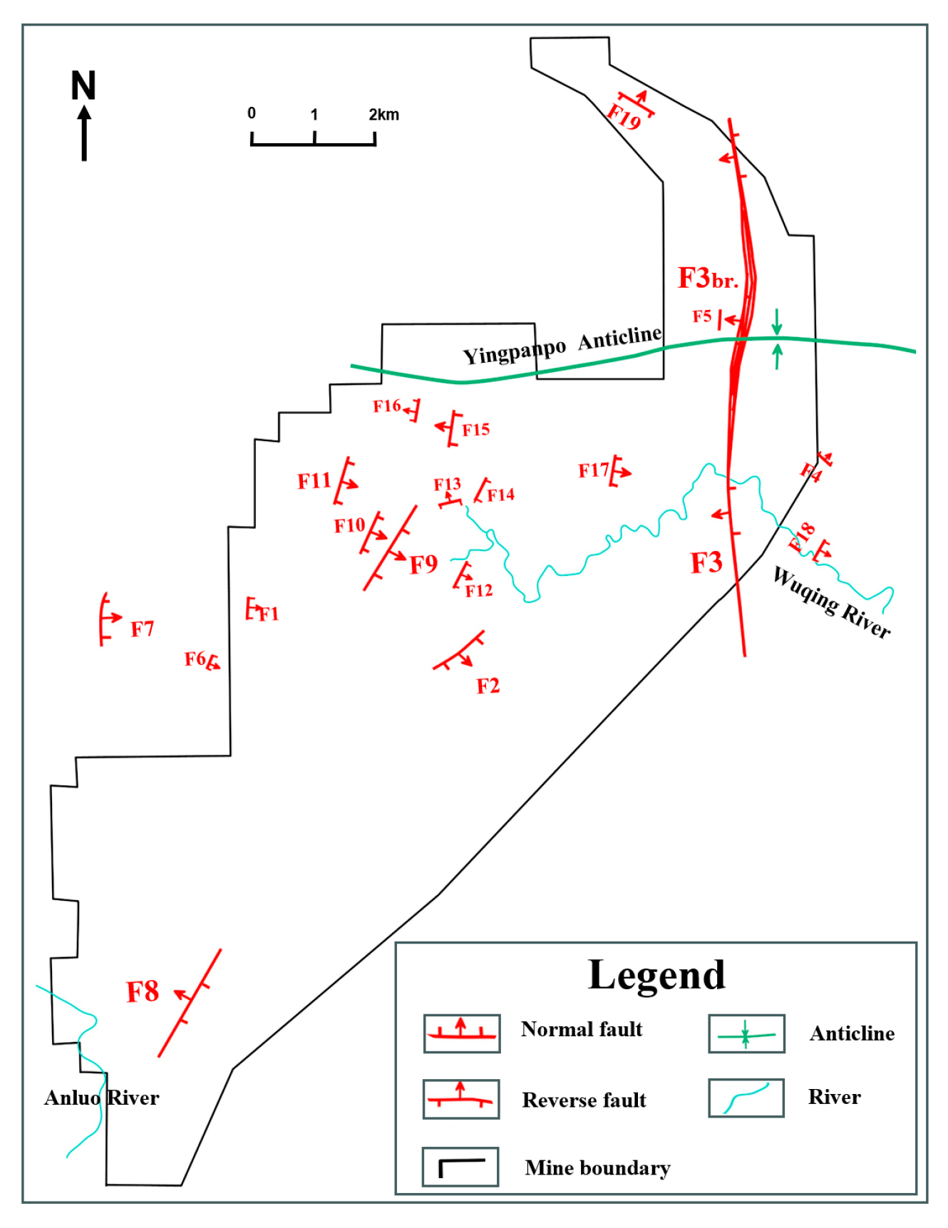
The Qinglong coal mine is located in a region with intense geological tectonic activity, where structural features are dominated by NE-trending folds and fault zones, accompanied by minor near-EW and NW-SE trending faults, as well as sporadically distributed WNW and near-EW oriented structures. The fold structures are characterized by broad asymmetrical anticlines and synclines. In the southeastern part of the mining area, the Gelaozhai anticline trends NE-SW, while the southwestern part contains the Dachong anticline and Dingjiazhai syncline, both trending NW-SE. Fault development exhibits clear directional and kinematic differentiation under regional tectonic control: faults in the northwestern section align roughly parallel to the axial trend of the Gelaozhai anticline, whereas structural trends in the southwest are largely consistent with the orientation of the Dachong anticline. The faults in this region are generally large in scale, with extensive continuity and steep dips, including both normal and reverse faults. Major faults such as F1, F2, F3, F4, and their branches exhibit significant throw, frequently cutting through key stratigraphic units including the Longtan, Changxing, and Yelang formations. Some fractures even extend to the surface, forming preferential pathways for groundwater migration. As a result, surface water bodies—such as the Tuohe River and precipitation—infiltrate into aquifers and coal seams in the form of fault water, significantly influencing the hydrogeological conditions of the mine (Figure 1).
In the Longfeng mine field, the Yingpanpo anticline is developed in the central–northern part and serves as the main structural framework. Except for the relatively large-scale F3 reverse fault, all other faults are small with throws mostly less than 15 m, exerting limited impact on the overall continuity of the coal-bearing strata. These faults predominantly develop within the Changxing and Longtan formations and do not disrupt the shale aquiclude of the Shabaowan Member. Consequently, the coal seams are scarcely affected by fault water (Figure 2).

3. Methods

This study collected core samples from the Changxing and Longtan Formations in the Longfeng and Qinglong mining areas. Rock samples were selected from the northeastern, central, and southwestern sections of each mining area, along with lithological logging data from 69 boreholes in Longfeng and 63 boreholes in Qinglong. A total of 12 limestone samples were prepared as thin sections for petrographic observation, and an additional 20 samples were used for petrophysical analysis.

3.1. Core Observation and Thin Section Analysis

Sedimentary facies indicators are essential for identifying depositional environments. Core samples from both mining areas were examined for rocks, color, sedimentary structures, and other facies-related features. Thin sections were prepared from limestone aquifer layers to analyze microfossils indicative of the depositional setting. Based on the sedimentary background, the depositional environments and microfacies types in the study area were systematically determined.

3.2. Distribution of Sedimentary Microfacies

To analyze the planar distribution variability of coal seam roof sediments, a sand-body distribution map was constructed using lithological logging data from 132 boreholes. The map was based on the proportional relationship among fine sandstone, siltstone, muddy siltstone, silty mudstone, and mudstone. Representative boreholes from the northeastern, central, and southwestern parts of the study area were selected according to the sand-body thickness distribution to establish sedimentary facies models. By integrating these models with the planar sedimentary distribution of the coal seam roof, the influence of lateral and vertical sedimentary variations on roof water abundance was evaluated.

3.3. Nitrogen Adsorption Tests and NMR Analysis

A total of 20 rock samples—10 each from Qinglong and Longfeng—including limestone, fine sandstone, siltstone, and muddy siltstone, were selected. Nitrogen adsorption and nuclear magnetic resonance (NMR) analyses were conducted to determine the water storage characteristics of these water-bearing rocks. These methods quantitatively assessed differences in water abundance and permeability between the roof aquifers of the two mining areas.

3.4. Hydrochemical Analysis Experiment

To determine the sources of water inflow into the mine roof, systematic sampling was carried out at various locations throughout the study area. Water samples were collected from working faces, goafs, the Changxing Formation aquifer, the Shabaowan Member, the Yulongshan Member, and surface water bodies. A total of 51 samples were acquired—27 from Qinglong Mine and 24 from Longfeng Mine. The salinity and hydrochemical composition of these samples were analyzed to compare the hydrochemical characteristics between aquifer groundwater and water collected from working faces. This comparison aids in identifying potential recharge sources and flow pathways, thereby supplying hydrogeochemical evidence for assessing water inrush risks and guiding prevention strategies related to roof aquifers.

4. Results and Discussion

4.1. Roof Sedimentary Characteristics

4.1.1. Sedimentary Facies Indicator

① Lithological Characteristic
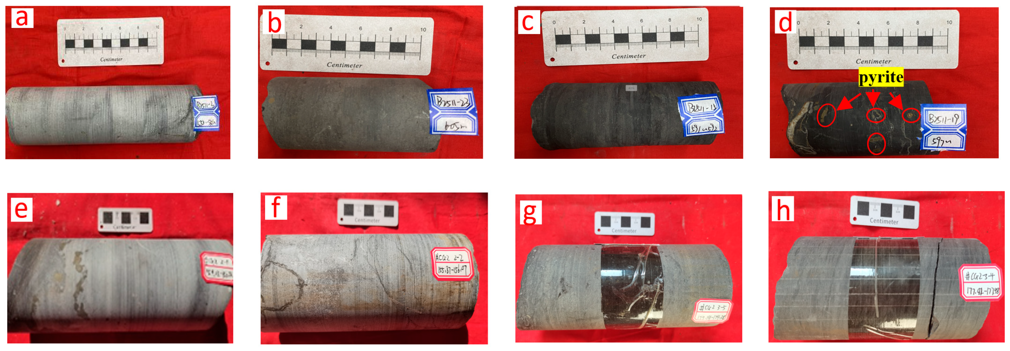
The rocks and color characteristics of the Changxing and Longtan Formations reflect different sedimentary conditions. The Changxing Formation is dominated by light gray limestone (Figure 3a,e,f), indicating that the sedimentary environment is abundant in sunlight and oxygen, and the hydraulic energy is weak. The L1 and L2 limestones developed at the top of the Longtan Formation are gray to dark gray, showing a weak reducing environment. The lower part of the formation has complex rocks, including mudstone, silty mudstone, siltstone, fine sandstone, and coal, deposited in thin alternating layers. The mudstone contains pyrite, and the overall color is dark gray to black, indicating a high organic matter content and weak to strong reducing sedimentation conditions. Comparing the color characteristics of the rocks in the Longtan Formation of the Qinglong and Longfeng mining areas, the Longfeng Coal Mine has darker colors, reflecting a stronger reducing ancient sedimentary environment (Figure 3b,c,g,h). The differences in rocks and color are mainly controlled by factors such as rock composition, structure, organic matter content, redox conditions, and later diagenesis. Dark colors are usually associated with high organic matter content, strong reducing environments, and low-energy water movement.
② Sedimentary Structure
Sedimentary structures directly reflect the properties of the sedimentary medium, hydrodynamic conditions, and energy setting, and serve as important indicators for distinguishing sedimentary facies, subfacies, and microfacies. According to core observations and logging data, the sedimentary structural characteristics of the Changxing and Longtan Formations in the study area are as follows:
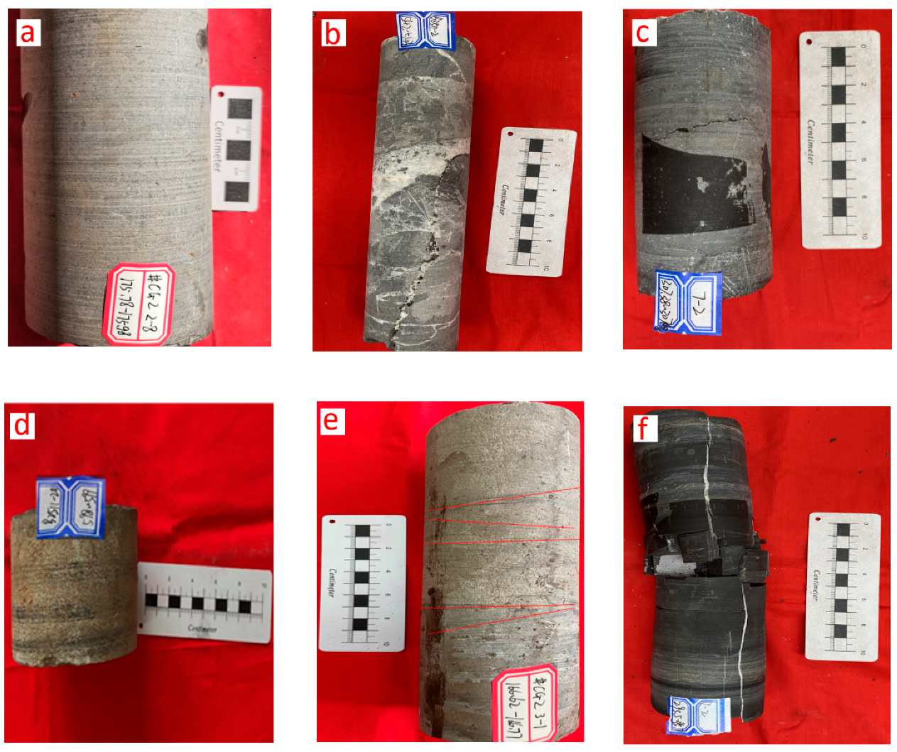
The Changxing Formation is dominated by horizontal bedding, dissolution fractures, and stylolites, with fractures primarily filled by calcite (Figure 4a–c). Dissolution fractures develop through the dissolution of carbonate rocks and are influenced by factors such as temperature, pressure, and fluid properties. These structural features suggest that the Changxing Formation was deposited in a relatively stable, low-energy aqueous environment, likely in a deep-water or quiescent setting.
In contrast, the Longtan Formation, which was significantly influenced by tidal activity, exhibits sedimentary structures including parallel bedding, cross-bedding, stylolites, calcite-filled fractures, and iron nodules (Figure 4d–f). The presence of cross-bedding indicates stronger hydrodynamic conditions, consistent with deposition in high-energy environments such as tidal flats, deltas, or shallow marine settings. The occurrence of iron nodules may be associated with variations in redox conditions.
③ Fossils
Fossils refer to the remains, relics, or traces of activities of ancient organisms preserved in rock strata, which lived during the geological past of Earth (typically older than 10,000 years before present), and they can serve as indicators of both the paleobiological habitats and the paleodepositional environments where ancient organisms lived and were buried [33]. Different types of fossils can reveal different sedimentary environmental characteristics.
As shown in Figure 5, the Changxing Formation contains abundant microfossils, including brachiopods and foraminifera (such as Forams, Endothyra, Fusuline, and Textulavia). During the Changxing period (Upper Permian), the paleoclimate was warm and humid, conditions that favored biological proliferation and also promoted carbonate dissolution and precipitation. Foraminifera, as micro-omnivorous organisms, feed on bacteria, algae, and other microscopic life, and tend to thrive in nutrient-rich settings. After death, their remains were buried and deposited along with carbonate sediments, eventually forming fossils. Foraminifera typically inhabit warm, clear shallow-marine environments such as carbonate platforms, lagoons, and tidal flats, though some species can adapt to deeper-water settings [34]. These fossils not only reflect the contemporary sedimentary environment but also provide important criteria for classifying sedimentary microfacies.
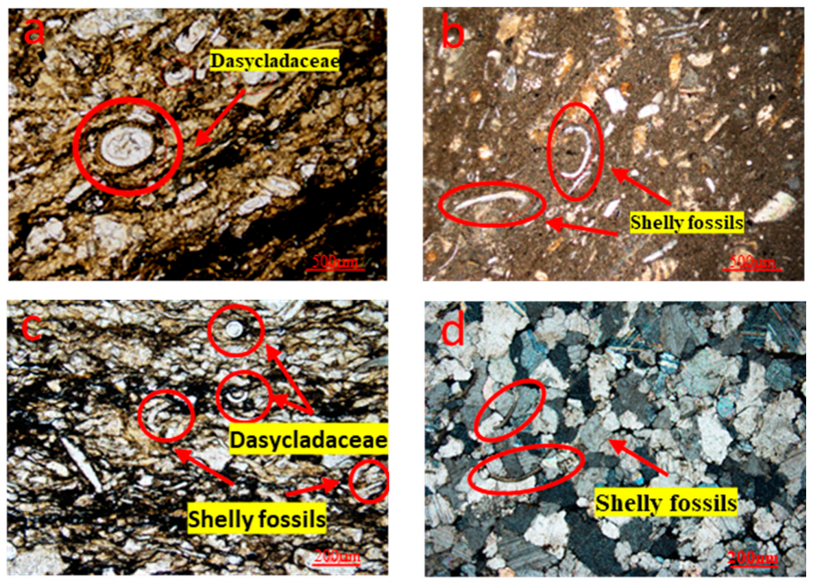
In the siltstone and fine-grained sandstone intervals of the Longtan Formation, algal fossils such as Dasycladaceae were identified, suggesting deposition in a shallow-water environment with active hydrodynamics. Dasycladaceae algae typically colonized hard substrates and flourished in organic-rich, calcareous sedimentary settings where nutrient availability supported their growth. After death, their remains contributed to the accumulation of organic-rich sedimentary rocks (Figure 6a,c). In certain limestone layers of the formation, well-preserved shelly fossils are observed. These fossils represent mineralized hard parts—primarily calcareous or siliceous shells—of ancient organisms that were preserved following burial. Water deepening associated with marine transgression led to their encapsulation in reducing marlstone under anoxic conditions, which enhanced fossil preservation (Figure 6b,d).

4.1.2. Types of Sedimentation

As shown in Table 1, the Changxing Formation represents an open-platform facies, which constitutes a significant component of the carbonate platform sedimentary system. It was deposited in shallow-water settings such as open lagoons, characterized by generally normal salinity, locally slightly hypersaline conditions, and moderate water circulation. The main rock type is argillaceous grain-supported limestone, with grain content ranging from 65% to 80%. Bioclasts are predominantly composed of algae, foraminifera, and gastropods. The rocks exhibit light gray, thick-bedded layers and commonly contain bioturbation structures. In contrast, the Longtan Formation is classified as a restricted platform facies, representing a lagoon sedimentary system. Its rocks consist mainly of peloidal limestone and micritic limestone, developed in intertidal to tidal flat environments. This formation can be further subdivided into subfacies such as microbial mounds, lagoons, and shoals, encompassing multiple sedimentary microfacies. Based on sedimentary facies indicators including rocks, color, sedimentary structures, and fossil content, the Changxing and Longtan Formations in the two study areas are divided into five sedimentary microfacies: skeletal bank, lime flat, mud flat, sand flat, and swamp.

4.1.3. Sedimentary Characteristics of the Changxing Formation

The Changxing Formation is predominantly composed of light gray limestone, characterized by sedimentary structures such as parallel bedding, pressure dissolution seams, and stylolites, and contains paleontological fossils including brachiopods and foraminifera. Its depositional type corresponds to the shoal subfacies within the open-platform facies, with the microfacies classified as a skeletal bank. The limestone strata of the Changxing Formation are widely distributed in both the Longfeng and Qinglong mining areas, exhibiting relatively stable thickness. Internally, the strata host diverse water storage spaces such as dissolution pores, vugs, and pressure dissolution seams, rendering it an indirect aquifer with heterogeneous water abundance above coal seams.

4.1.4. Sedimentary Characteristics of the Longtan Formation

On the basis of sedimentary facies indicators such as rocks, color, sedimentary structure and paleontological fossils, the tidal flat–lagoon subfacies in the platform facies of the formation is subdivided into four types of sedimentary microfacies: sandstone, mudflat, lime flat and swamp.
① Sand Flat Microfacies
The sand flat microfacies is predominantly composed of siltstone and fine sandstone, characterized by parallel bedding and cross-bedding, and deposited in hydrodynamically active shallow-water environments. It hosts algal fossils such as Dasycladaceae, which preferentially colonized rocky surfaces. The growth of Dasycladaceae was supported by organic-rich and calcareous sediments, providing essential nutrients. Postmortem accumulation of these algae contributed to the formation of organic-rich sedimentary rocks.
② Mud Flat Microfacies
The mud flat microfacies is predominantly composed of organic-rich dark mudstone and muddy siltstone, characterized by horizontal bedding and small-scale cross-bedding. It formed in deeper, low-energy, reducing environments where limited hydrodynamic activity allowed fine-grained sediments to accumulate.
③ Lime Flat Microfacies
The lime flat microfacies consists mainly of gray to dark-gray marlstone, exhibiting sedimentary structures such as stylolites and parallel bedding. It contains shelly fossils, composed of calcareous or siliceous minerals, which represent the hard parts of ancient organisms. These fossils were preserved in reducing marlstone under deepening water conditions caused by marine transgression, which facilitated anoxic burial and fossilization.
④ Swamp Microfacies
The swamp microfacies is dominated by coal and carbonaceous mudstone, enriched with higher plant fossils. This microfacies developed in gradually shallowing water bodies during regression, under warm and humid climatic conditions that promoted dense vegetation. Plant debris accumulated in waterlogged, oxygen-poor settings, forming peat that later underwent diagenesis to become coal.
Significant differences exist in the sedimentary characteristics of the Longtan Formation between the Longfeng and Qinglong mining areas. The Longfeng area is dominated by mud flat deposits, which are rich in muddy sediments, whereas the Qinglong area is characterized primarily by sand flat deposits with a higher proportion of sandy material. This lithological distinction exerts a direct control on aquifer distribution and groundwater occurrence patterns. In the Longfeng mining area, the mudstone formed under mud flat conditions acts as an effective aquiclude, thereby restricting groundwater flow. In contrast, the sand bodies developed in the sand flat environment of the Qinglong area provide favorable conditions for groundwater storage and migration, significantly increasing the potential risk of water hazards.

4.2. Distribution Patterns of Sedimentary Facies

4.2.1. Distribution Characteristics of Sand–Mud Ratio

The roof strata of the coal seam comprise mudstone, silty mudstone, argillaceous siltstone, siltstone, fine sandstone, and limestone. Among these rocks, limestone and sandstone constitute the direct aquifers above the coal seam, while mudstone and sandy mudstone act as impermeable layers. To evaluate the proportional relationship between aquifers and impermeable strata in the roof of the Qinglong and Longfeng coal mines, a comparative analysis was performed using planar contour maps of the sandstone-to-mudstone ratio across the study areas.
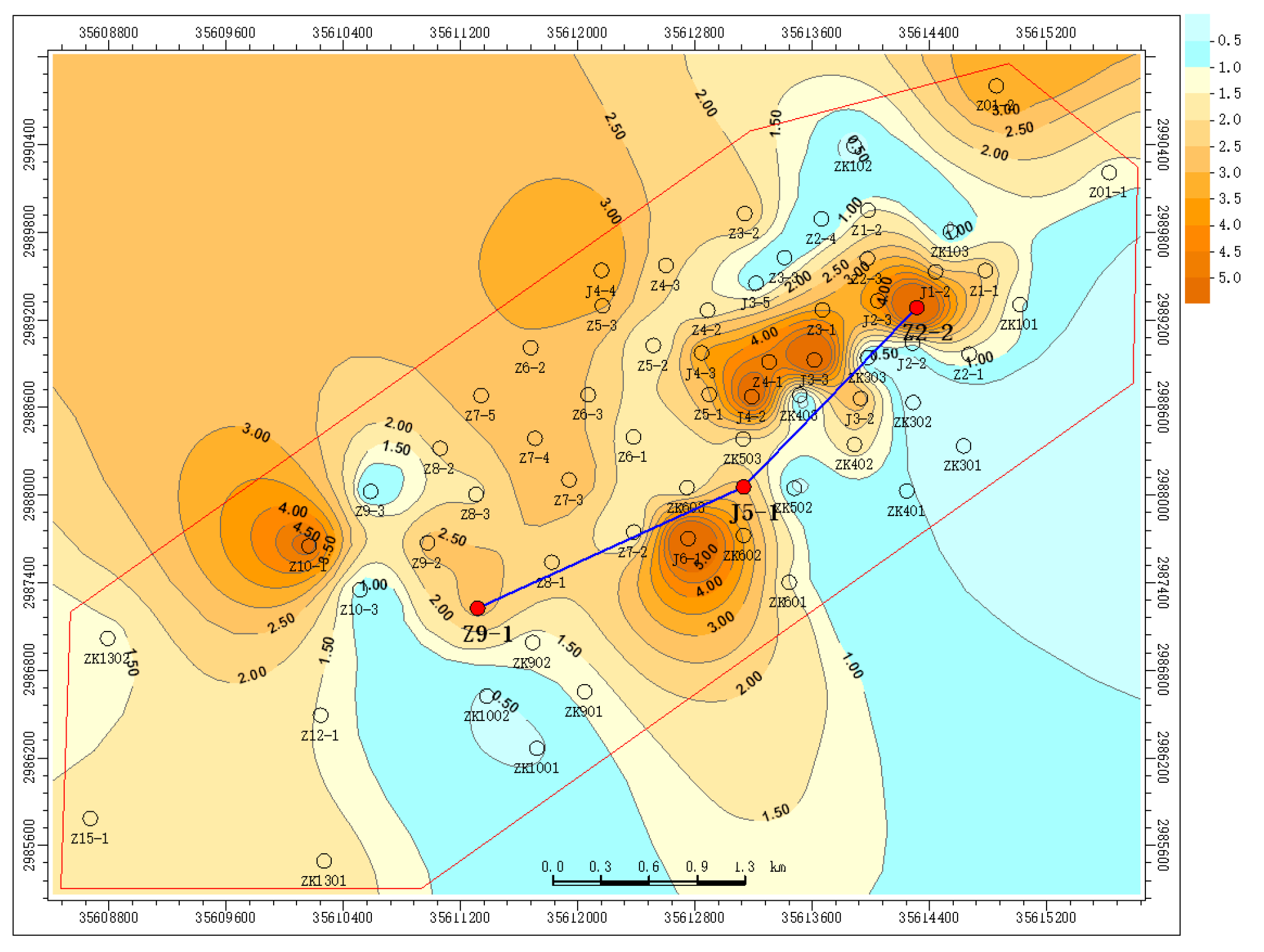
As shown in Figure 7, in the Longfeng mining area, the sand–mud ratio is generally less than 1, except for localized zones in the southwest where it exceeds 1. This indicates that the strata in this area are predominantly composed of mudstone and silty mudstone. In contrast, as illustrated in Figure 8, the Qinglong mining area exhibits the opposite pattern: the sand–mud ratio is mostly greater than 1, with only limited southeastern areas showing values below 1. This suggests that the strata here are mainly composed of argillaceous siltstone, siltstone, and fine sandstone.
The comparison indicates that the Longtan Formation in the Qinglong area contains a higher proportion of sandstone than that in the Longfeng area. Consequently, the roof of the No. 16 coal seam in Qinglong is dominated by water-bearing strata with relatively high water abundance, whereas the roof strata in Longfeng are primarily composed of impermeable layers.

4.2.2. Sedimentary Microfacies Model

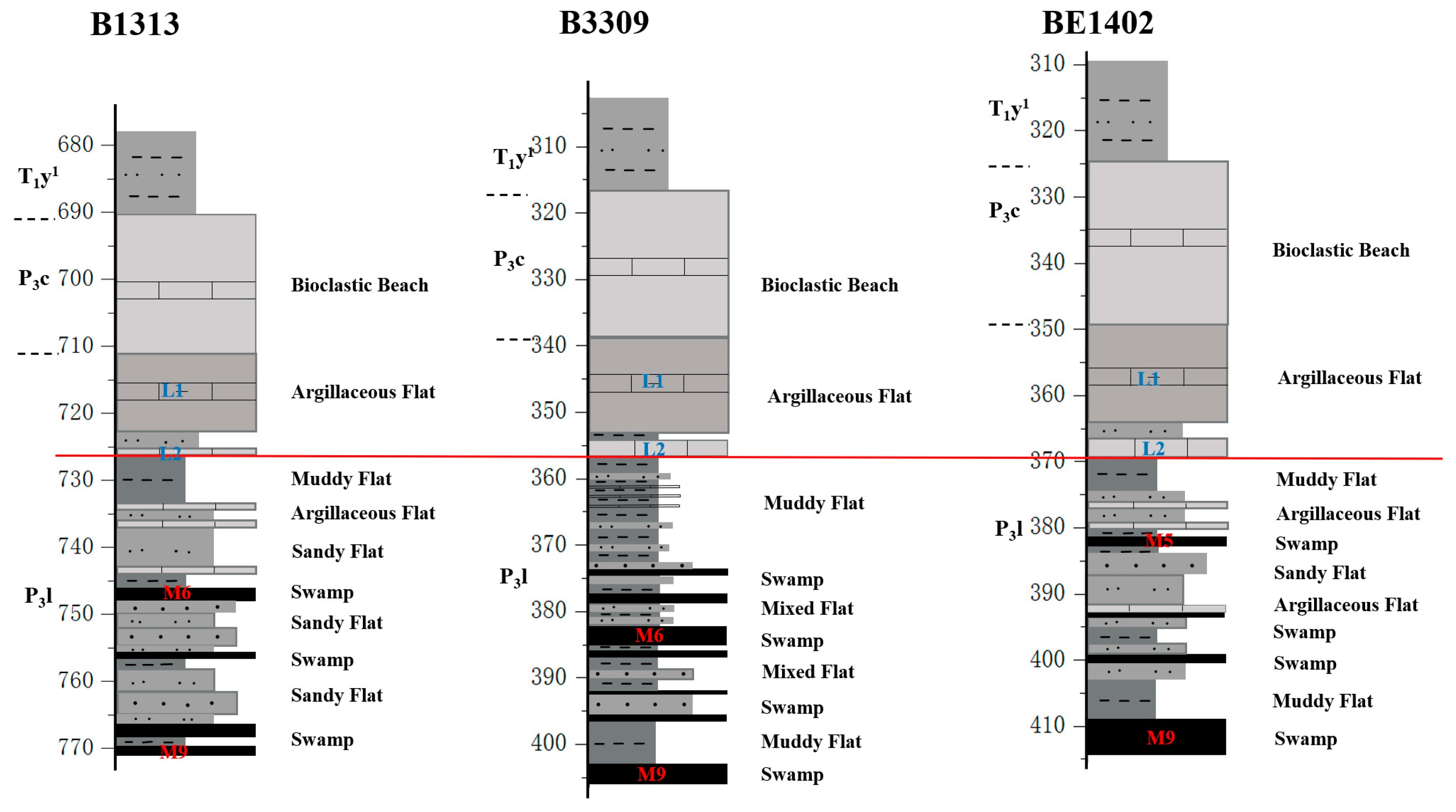
Using the contour map of sand–mud ratio distribution, we identified three representative single-well sedimentary facies models in the Longfeng mining area (Figure 7). By using the L1 and L2 limestones at the top of the Longtan Formation as reference baselines, the sedimentary characteristics of both the overlying Changxing Formation limestone and these baseline units exhibit high stability. Below the baselines, however, three distinct sedimentary patterns emerge:
The coal seams in this mining area are generally deeply buried, exceeding 400 m in depth, with the southwestern section reaching approximately 700 m. In the southwestern zone, the immediate roof of the No. 9 coal seam consists mainly of siltstone and fine sandstone, indicative of a sand-flat depositional environment. During mining operations in this area, particular attention should be given to the water-bearing and water-conducting capacity of these sandstone units. In the central part of the mining area, the immediate roof is dominated by mudstone and silty mudstone, reflecting deposition in a mud-flat setting. These strata exhibit effective aquiclude properties, minimizing the hydrological influence from the overlying Changxing Formation and L1–L2 limestone aquifers on coal seam extraction. In the northeastern zone, the coal seam roof is also primarily composed of sand-flat deposits. However, due to the presence of the F1 fault and associated fracture systems, hydraulic connectivity with overlying aquifers may be enhanced. Mining activities in this region should therefore account for the potential water-conducting effects of these structural features (Figure 9).
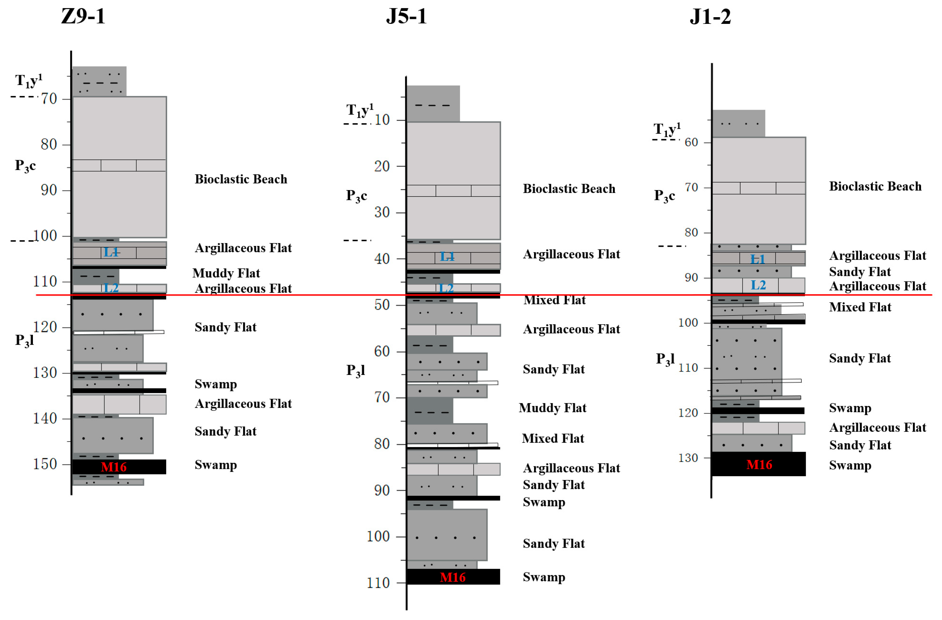
Using the sand–mud ratio contour map, we selected three representative boreholes to construct single-well facies models for the Qinglong Coal Mine. The study reveals that the overall characteristics of Qinglong Coal Mine are highly similar to those of Longfeng Coal Mine. The deposition of the Changxing Formation and the L1 and L2 limestones at the top of the Longtan Formation remains relatively stable, whereas the sedimentary layers between the No.16 coal seam and the L2 limestone exhibit certain variations, with the central section showing greater depositional thickness compared to the southwestern and northeastern sections.
These differences are mainly attributed to the development of normal and reverse faults in the region, which have caused repetition and local absence of certain strata. Additionally, the Qinglong Coal Mine is characterized by shallow burial depths, generally ranging between 110 and 150 m. The immediate roof of the No. 16 coal seam is composed predominantly of sandstone interbedded with thin layers of limestone and mudstone, forming a cyclic depositional sequence (Figure 10). Both the limestone flat and sand-flat deposits can act as direct aquifers for the coal seam roof, indicating higher water abundance in the Qinglong mining area compared to Longfeng. When mining-induced fractures propagate and penetrate the thin mudstone aquiclude at the base of the aquifer, stored groundwater may percolate downward, increasing the potential risk of water inflow or inrush events.

4.2.3. Planar Sedimentary Characteristics

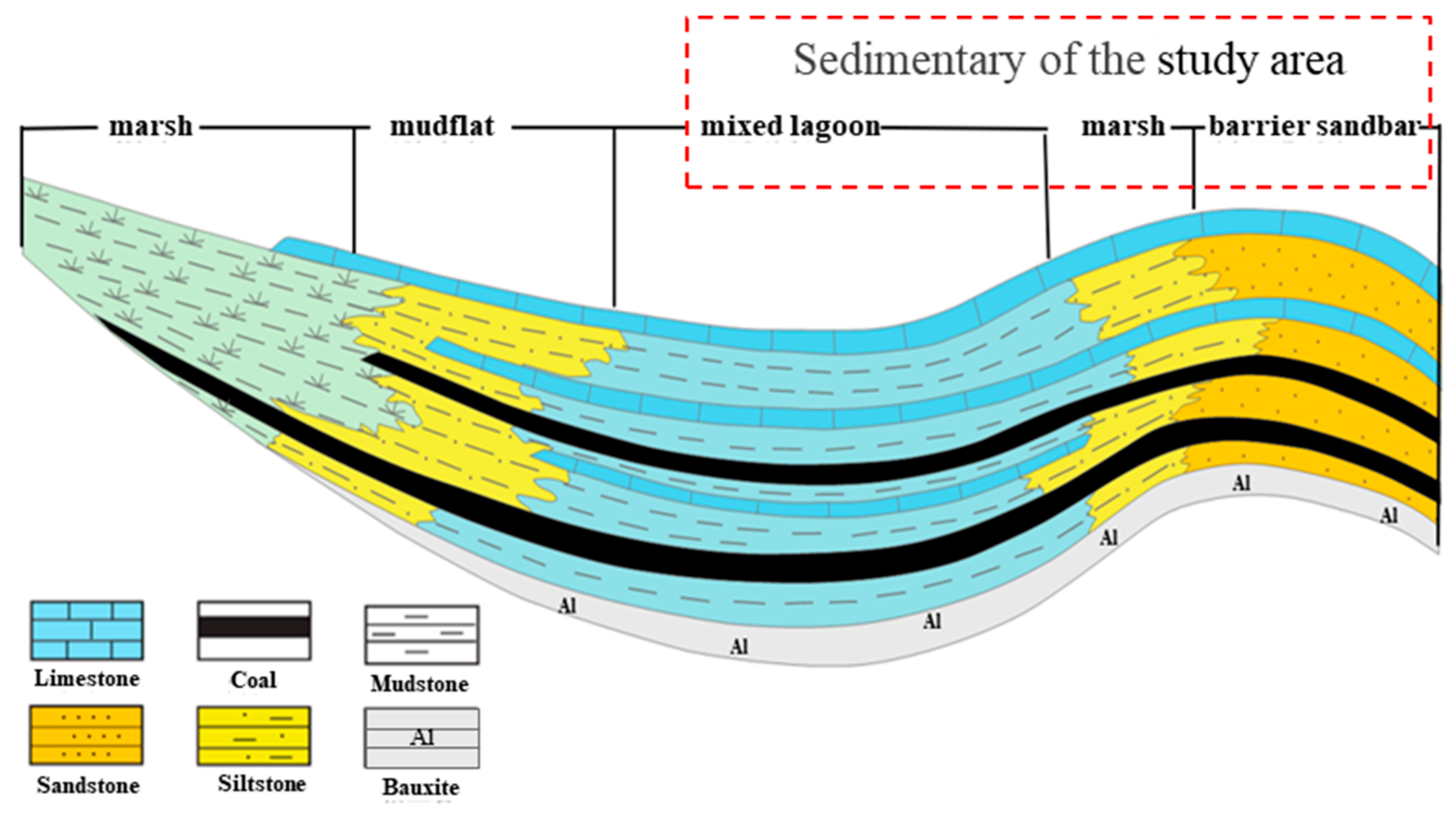
Figure 11 shows the tidal flat–lagoon depositional model of the barrier island system in the study area. Both Qinglong and Longfeng coal mine are located near the barrier sandbar, but with distinct differences: Longfeng coal mine is situated behind the barrier sandbar where hydrodynamic conditions are weaker, favoring deposition of finer-grained sediments such as various mudstones and siltstones. In contrast, Qinglong coal mine is located at the tidal inlet where strong alternating tidal currents transport coarser sediments, resulting in better-developed sand bodies.
The single-well sedimentary microfacies model reveals that the Changxing Formation, L1, and L2 limestone aquifers in the study area exhibit stable deposition, with lithofacies variations only occurring between the coal seam and L2 limestone. Therefore, this study focuses on analyzing the planar distribution of sedimentary microfacies in the upper Longtan Formation.
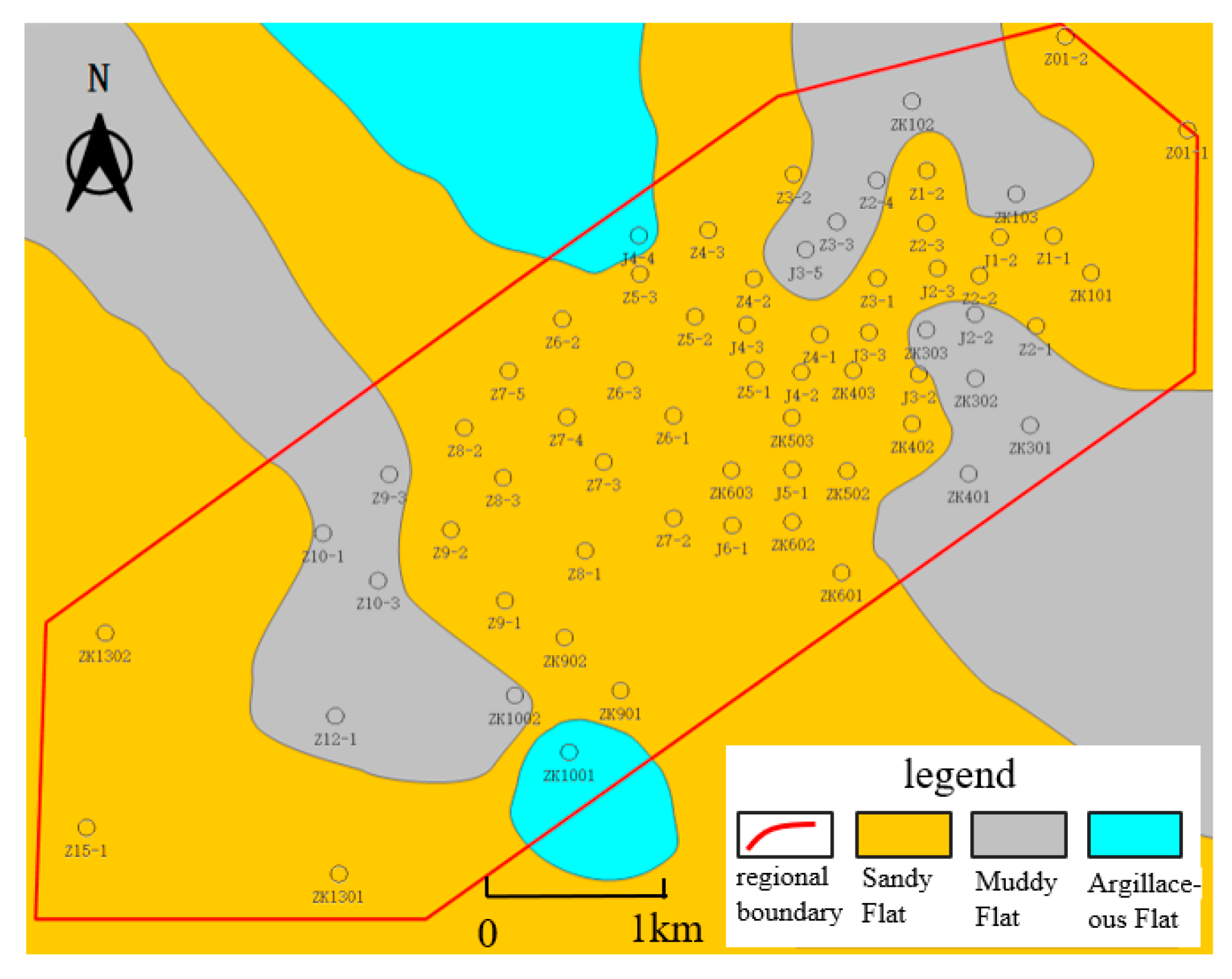
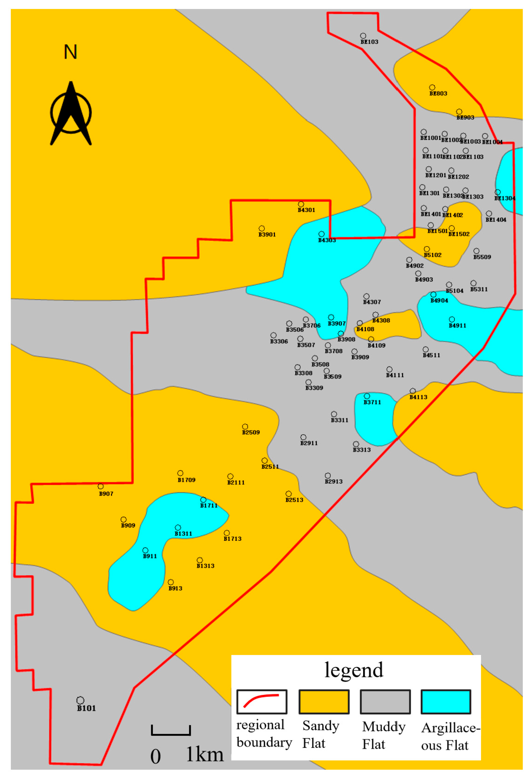
The planar distribution maps of sedimentary microfacies in the upper Longtan Formation of Longfeng and Qinglong Coal Mine (Figure 12 and Figure 13) demonstrate distinct depositional patterns. The Qinglong mining area is dominated by sand-flat deposits, with localized mud-flat occurrences, whereas the Longfeng mining area primarily consists of mud-flat deposits, followed by sand-flat deposits.
These differences in planar sedimentary characteristics reflect variations in depositional environments and sediment supply between the two mining areas, leading to disparities in the water-bearing and water-blocking properties of the coal seam roof. In the Longfeng mining area, mud-flat-deposited mudstones form effective aquicludes, whereas in the Qinglong mining area, sand-flat-deposited sand bodies provide favorable conditions for groundwater storage and migration, thereby increasing the risk of water hazards.

4.3. Rock Physical Property Analysis

Nitrogen adsorption tests and NMR (Nuclear Magnetic Resonance) analysis were conducted on a total of 20 rock samples of muddy siltstone, siltstone, and fine sandstone from the Longtan Formation in both Longfeng and Qinglong mining areas. The results yielded average porosity and permeability data for the respective rock types (Figure 14). The data show that in both Longfeng (porosity: 1.8%, 4.2%, 7.5%; permeability: 0.42 mD, 0.63 mD, 1.15 mD) and Qinglong (porosity: 2.1%, 6.2%, 9.4%; permeability: 0.44 mD, 0.81 mD, 1.27 mD) mining areas, porosity and permeability increase significantly as the rock transitions from muddy siltstone to siltstone and then to fine sandstone. This reveals that the water storage capacity of sandstone aquifers is controlled by clay content and mineral grain size, specifically manifested as an improvement in petrophysical parameters with decreasing clay content and increasing mineral grain size. Further comparison indicates that the porosity and permeability of equivalent sandstones in the Qinglong mining area are slightly higher than those in Longfeng, suggesting that the immediate roof aquifer in Qinglong possesses enhanced storage capacity. Integrating regional geological characteristics, the Qinglong area exhibits greater development of fine-to-silty sandstones, with its dominant sedimentary microfacies—the sandy flat facies—being more extensively distributed both vertically and laterally. This establishes a clear control chain: the sedimentary microfacies (sandy flat facies) governs the dominant lithological assemblage (fine-to-silty sandstones), the lithological assemblage controls the rock petrophysical properties (low clay content and coarser grains leading to higher porosity and permeability), and these petrophysical properties ultimately determine the water richness of the roof aquifer. Therefore, the widespread development of the sandy flat microfacies in the Qinglong mining area is the fundamental geological cause of its stronger roof and water-rich conditions, and the distribution characteristics of sedimentary microfacies within the study area can serve as a key basis for predicting the water storage capacity of coal seam roof aquifers.

4.4. Hydrochemical Analysis

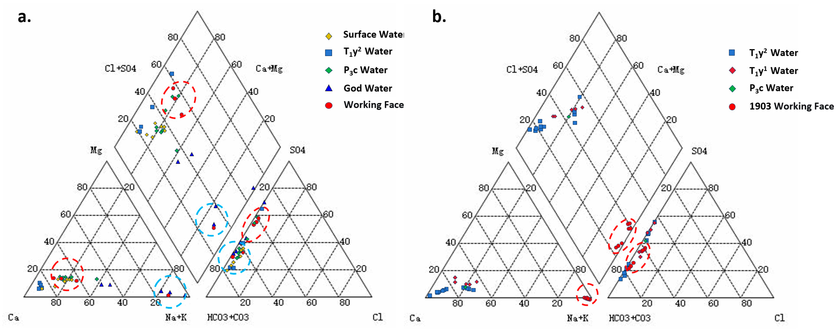
Hydrochemical trilinear plot analysis of formation water mineralization levels indicates that the water quality in the working face of the Qinglong mining area is of the HCO3·SO4-Ca type, which is highly consistent with the hydrochemical characteristics of the karst water in the Changxing Formation and the goaf water (Figure 15a), reflecting the multi-source composite nature of water influx sources in the roof water hazard in this mining area. Further analysis reveals a significant similarity in the chemical composition between the formation water in the Changxing Formation, the Yulongshan Section formation water, and surface water. Their hydraulic connectivity is primarily controlled by fault and microfracture networks, which form effective water-conducting channels, thereby enhancing the water abundance of the direct aquifer in the Changxing Formation. In contrast, the water quality in the working face of the Longfeng mining area is of the HCO3·SO4-Na type, while the cationic composition of its roof aquifer is dominated by Ca2+ (Figure 15b), indicating that the water influx does not originate directly from the roof aquifer. This indirectly suggests weak hydraulic connectivity between the aquifer and the coal seam, as well as a relatively closed groundwater system. Combined with pumping test results from 10 boreholes targeting the Changxing Formation aquifer in the Longfeng mining area, the water yield ranges between 0 and 0.1459 L/s m, with frequent occurrences of dry-out phenomena, further confirming the weak water abundance of the direct aquifer in this area.

5. Conclusions

On the basis of rocks, sedimentary structures, paleontological fossils, and other facies indicators, this study subdivides the carbonate platform facies and tidal flat–lagoon facies of the Changxing and Longtan Formations in both mining areas into five sedimentary microfacies: bioclastic bank, swamp, mud flat, lime flat, and sand flat. It reveals that Longfeng Coal Mine is dominated by mud flat deposits, with roof mudstone exhibiting strong aquiclude properties and low water hazard risk. In contrast, Qinglong Coal Mine is characterized by sand flat deposits, where roof sandstone possesses favorable reservoir and permeability properties, resulting in high water hazard risk.
The development of the sand flat microfacies in the Qinglong mining area facilitates the distribution of low-clay, coarse-grained sandstone. Petrophysical analyses reveal significantly higher porosity and permeability in Qinglong compared to the Longfeng mining area, endowing the roof aquifer with greater water abundance. Furthermore, the shallow burial depth of the coal seam in Qinglong allows weathering fractures and faults within the exposed limestone aquifer to readily receive surface water recharge, increasing the potential for water inrush. Sedimentary microfacies thus influence aquifer water abundance by controlling lithological assemblages, which in turn determine petrophysical properties.
Geological structural conditions further exacerbate the differences in hydrogeological conditions between the two mining areas: Qinglong Coal Mine exhibits large-scale faults with strong water-conducting capacity, which establish hydraulic connections between surface water bodies and aquifers, whereas Longfeng Coal Mine has faults of small scale and limited throw, which do not disrupt key aquiclude layers, resulting in a relatively closed hydrogeological system. Hydrochemical analysis corroborates these differences: the water quality in the working face of Qinglong Mine is highly consistent with that of karst water and goaf water, indicating multi-source composite recharge; in contrast, Longfeng Mine shows weak hydraulic connectivity between the aquifer and the coal seam.
Therefore, predicting and assessing water abundance risks in coal seam roofs can be achieved by analyzing the distribution of sedimentary microfacies. For prevention and control, the sources and pathways of water inflow should first be identified. Tailored measures for different mining areas include optimizing mining layouts and controlling roof fracture development in the Qinglong mining area, and strengthening monitoring of aquiclude layers in local fault zones in the Longfeng mining area. Effective water hazard mitigation can be realized through a combination of “source drainage” and “pathway sealing”.

Author Contributions

Methodology, Investigation, Writing—original, Writing—review & editing, Project administration, J.F.; Methodology, Investigation, Writing—original, Writing—review & editing, Project administration, E.H.; Date curation, S.W.; Investigation, K.Z.; Supervision, Y.L.; Investigation, K.G.; Investigation, L.W.; Methodology, H.Y. All authors have read and agreed to the published version of the manuscript.

Funding

Supported by Guizhou Provincial Major Scientific and Technological Program, Research and Demonstration Project on Key Technologies for Comprehensive Prevention and Control of Major Disasters in Guizhou Coal Mines (No. [2024]029).

Data Availability Statement

The original contributions presented in this study are included in the article. Further inquiries can be directed to the corresponding author.

Acknowledgments

The authors thank the reviewers for their valuable comments and are grateful to the editor for careful editing.

Conflicts of Interest

Authors Juan Fan, Shidong Wang, Kaipeng Zhu, Yingfeng Liu and Kang Guo were employed by the China Coal Technology and Engineering Group Corp. The remaining authors declare that the research was conducted in the absence of any commercial or financial relationships that could be construed as a potential conflict of interest.

References

  1. Liu, J.; Yang, J.; Wang, Q. Study on water abundance of roof aquifer of coal seam based on deposition law of formations. Saf. Coal Mines 2018, 49, 69–72. [Google Scholar] [CrossRef]
  2. Fang, G.; Cai, Y. Study on water yield property zoning in Balasu well field based on sedimentary water control analysis. J. Arid. Land Resour. Environ. 2019, 33, 105–111. [Google Scholar] [CrossRef]
  3. Wang, X. Probe in Mechanism of Roof Water Burst in Mines. J. Min. Strat. Control Eng. 2007, 12, 74–76. [Google Scholar]
  4. Li, Z.; Chen, J.; Gong, H.; Niu, P.; Zeng, Y.; Liu, S. Risk evaluation of water inrush in poor water yield capacity aquifer of coal seam direct roof. Saf. Coal Mines 2018, 49, 181–184. [Google Scholar] [CrossRef]
  5. Feng, S.; Li, F.; Zhang, X. Study on water richness of coal seam roof aquifer based on different dimensionless methods. Coal Technol. 2016, 35, 221–222. [Google Scholar] [CrossRef]
  6. Huang, H. Study on roof drainage technology based on sedimentation analysis. West-China Explor. Eng. 2018, 30, 117–119. [Google Scholar] [CrossRef]
  7. Feng, S. Coal seam roof aquifer water-richness evaluation based on multiple source geology information fusion. Coal Chem. Ind. 2016, 39, 9–11. Available online: http://www.mtyhg.com.cn/CN/Y2016/V39/I6/9 (accessed on 28 September 2025).
  8. Chen, M.; Pan, S.; Yuan, D. Fuzzy comprehensive evaluation method of the aquifer water abundance of coal seam roof. Resour. Environ. Eng. 2016, 30, 608–611. [Google Scholar] [CrossRef]
  9. Di, C.; Ding, X.; Huang, H. Practice of roof water exploration and drainage technology in deep-buried Jurassic coal seam: Take the Hulusu mine in Hujit mining area as an example. Coal Geol. Explor. 2016, 44, 96–100. [Google Scholar] [CrossRef]
  10. Shi, S.; Wei, J.; Yin, H.; Xie, D.; Yang, J. Water-rich prediction of sandstone aquifer on coal seam roof in Jisan coal mine. Coal Geol. Explor. 2017, 45, 100–104. [Google Scholar] [CrossRef]
  11. Li, Y.; Wang, J.; Wei, I.Q. Application of transient electromagnetic method in detecting water conducting cracks on roof of underground working face. Coal Geol. Explor. 2018, 46, 66–71. [Google Scholar] [CrossRef]
  12. Baxter, N.G.; Watson, T.P.; Whittaker, B.N. A study of the application of T-H support systems in coal mine gate roadways in the UK. Int. J. Rock Mech. Min. Sci. Geomech. Abstr. 1990, 27, 291. [Google Scholar] [CrossRef]
  13. Williams, G. Roof bolting in south wales. J-GLOBAL 1987, 235, 311–314. [Google Scholar]
  14. Li, H.; Bai, H.; Wu, J.; Meng, Q.; Ma, K.; Wu, L.; Meng, F.; Wang, S. A Set of Methods to Predict Water Inrush from an Ordovician Karst Aquifer: A Case Study from the Chengzhuang Mine, China. Mine Water Environ. 2019, 38, 39–48. [Google Scholar] [CrossRef]
  15. Zhang, X. Model-based Seismic Imaging and Analysis of Karst Water Hazards in Coal Mining. Mine Water Environ. 2021, 40, 321–323. [Google Scholar] [CrossRef]
  16. Qian, M.; Miao, L.; Xu, J. Key Strata Theory in Strata Control; China University of Mining and Technology Press: Xuzhou, China, 2003. [Google Scholar]
  17. Gao, Y. The “Four Zones” Model of Rock Movement and Dynamic Displacement Back Analysis. J. China Coal Soc. 1996, 21, 51–52. [Google Scholar]
  18. Gao, Y.; Deng, Z.; Yang, Z.; Li, W.; Xie, H. Theoretical Study on Grouting for Reducing Surface Subsidence by Separated Bed in Overlying Strata. Ground Press. Strat. Control 2001, 4, 65–67. Available online: https://www.chinacaj.net/i,2,128349,0.html (accessed on 28 September 2025).
  19. Gao, Y.; Zhang, Q.; Niu, C.; Zhang, K. Analysis of actual measurement of cracks in overlying rock on roof of gob-side entry retaining during secondary mining. Coal Sci. Technol. 2022, 50, 78–84. [Google Scholar] [CrossRef]
  20. Liu, S.; Fan, Z.; Yin, X.; He, X.; Zhao, H.; Wen, J.; Liu, H. Key Technologies for Prevention and Control of Water-Sand Inrush Disaster in Fully Mechanized Caving Mining Under Water-Rich Aquifer. J. China Coal Soc. 2020, 45, 2880–2889. [Google Scholar] [CrossRef]
  21. Zhang, G.; Tao, G.; Meng, X.; Li, Y.; Qu, Z.; Xu, R.; Yu, S.; Chen, M.; Zhou, G.; Luan, H. Failure Law of Weak Overlying Strata Under Ultra-Thick Loose Layer. J. China Coal Soc. 2022, 47, 3998–4010. [Google Scholar]
  22. Song, G.; Huang, P.; Zan, M.; Zhang, P.; Kong, D. Reasonable Staggered Distance Determination and Overburden Damage Characteristics for Simultaneous Mining Faces in Contiguous Coal Seams. Coal Eng. 2024, 56, 1–7. [Google Scholar]
  23. Sun, X.; Shao, X.; Zheng, Y.; Zhang, T.; Zhao, Z.; Xie, T. Evaluation of the Impact of Deep Coal Seam Mining on River Safety. Saf. Coal Mines 2024, 55, 195–203. [Google Scholar] [CrossRef]
  24. Ding, Z.; Wang, S.; Liao, J.; Li, L.; Jia, J.; Tang, Q.; Li, X.; Gao, C. Reasonable Working-Face Size Based on Full Mining of Overburden Failure. Sustainability 2023, 15, 3351. [Google Scholar] [CrossRef]
  25. Yang, Y.; Zhao, G. Study on Overburden Failure Characteristics and Stress Transfer Law Under Multiple Mining in Close-Distance Coal Seam Group. Coal Eng. 2024, 56, 110–116. [Google Scholar]
  26. Liu, Y.; Yang, T.; Deng, W.; Liu, H.; Gao, Y.; Ma, K.; Zhao, Y.; Sun, D. Characteristics of Overburden Damage and Rainfall-Induced Disaster Mechanisms in Shallowly Buried Coal Seam Mining: A Case Study in a Gully Region. Sustainability 2024, 16, 7538. [Google Scholar] [CrossRef]
  27. Li, H.; Tang, S.; Ma, L.; Bai, H.; Kang, Z.; Wu, P.; Liao, X. A Coupled Continuous-Discrete Simulation Study on Progressive Failure of Overlying Strata Induced by Mining. Chin. J. Rock Mech. Eng. 2022, 41, 2299–2310. [Google Scholar] [CrossRef]
  28. Zhang, Y. Numerical Simulation of Overburden Failure Characteristics and Water Inflow Prediction Based on Solid-Fluid Coupling Theory. J. China Coal Soc. 2009, 34, 610–613. [Google Scholar] [CrossRef]
  29. Sun, Y.; Xu, Z.; Dong, Q. Monitoring and Simulation of Water-Conducting Fracture Development in Coal Mining Under Xiaolangdi Reservoir. Chin. J. Rock Mech. Eng. 2009, 28, 238–245. [Google Scholar] [CrossRef]
  30. Xu, B.; He, M. Geology of Guizhou Coal Fields; China University of Mining and Technology Press: Xuzhou, China, 2003. [Google Scholar]
  31. Guizhou Provincial Coal Geology Bureau. Prediction and Evaluation of Coal Resources in Guizhou Province; Guizhou Provincial Coal Geology Bureau: Guiyang, China, 1994. [Google Scholar]
  32. Wang, Y.; Liu, Z.; Li, L. Characteristics of Coal Seam Sulfur in the Permian System of the Northern Guizhou Coal Field and Sedimentary Environment Study. Coal Sci. Technol. 2017, 45, 185–190. [Google Scholar] [CrossRef]
  33. Murray, J.W. Ecology and Applications of Benthic Foraminifera; Cambridge University Press: Cambridge, UK, 2006. [Google Scholar]
  34. Flügel, E.; Munnecke, A. Microfacies of Carbonate Rocks: Analysis, Interpretation and Application; Springer: Berlin/Heidelberg, Germany, 2010; Volume 976. [Google Scholar]
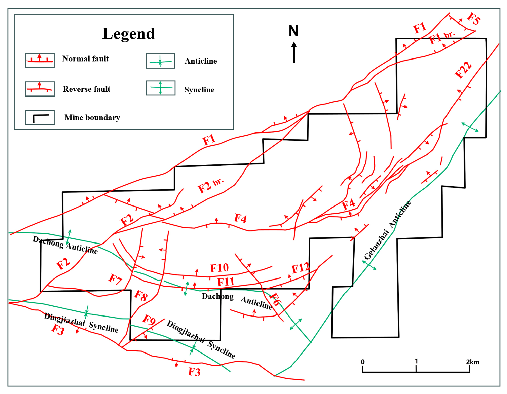
Figure 1. Structural Map of the Qinglong Mining Area.
Processes 13 03353 g001
Figure 2. Structural Map of the Longfeng Mining Area.
Processes 13 03353 g002
Figure 3. Rocks and color characteristics of Changxing Formation and Longtan Formation (Longfeng: (ad); Qinglong: (eh); (a) P3c, Limestone, light grey; (b) P3l, Limestone, grey; (c) P3l, Argillaceous siltstone, grayish-black; (d) P3l, Mudstone, dark black, pyrite; (e) P3c, lime stone, light gray; (f) P3c, lime stone, light gray; (g) P3l, lime stone, grey; (h) P3l, Argillaceous siltstone, dark gray).
Processes 13 03353 g003
Figure 4. Sedimentary structure of Changxing and Longtan formation (Changxing: (ac); Longtan: (df); (a) horizontal bedding; (b) dissolution fracture; (c) Stylolites; (d) Parallel bedding; (e) Cross-bedding; (f) horizontal bedding).
Processes 13 03353 g004
Figure 5. Paleontological fossils f the Changxing Formation (Longfeng: (ac); Qinglong: (df)).
Processes 13 03353 g005aProcesses 13 03353 g005b
Figure 6. Paleontological fossils of the Changxing Formation (Longfeng: (a,b); Qinglong: (c,d)).
Processes 13 03353 g006
Figure 7. Plane contour diagram of stratigraphic sand–mud ratio in Longtan Formation of Longfeng Coal Mine.
Processes 13 03353 g007
Figure 8. Plane contour diagram of stratigraphic sand–mud ratio in Longtan Formation of Qinglong Coal Mine.
Processes 13 03353 g008
Figure 9. Microfacies model diagram of single-well sedimentation in Longfeng Coal Mine (Red line: Reference baseline; Dashed line: Stratigraphic boundary).
Processes 13 03353 g009
Figure 10. Microfacies model diagram of single-well sedimentation in Qinglong Coal Mine (Red line: Reference baseline; Dashed line: Stratigraphic boundary).
Processes 13 03353 g010
Figure 11. Pattern of tidal flat–lagoon sedimentation in the study area.
Processes 13 03353 g011
Figure 12. Microfacies distribution map of coal seam roof sedimentation in Longtan Formation, Longfeng mining area.
Processes 13 03353 g012
Figure 13. Microfacies distribution map of coal seam roof sedimentation in Longtan Formation, Qinglong mining area.
Processes 13 03353 g013
Figure 14. The porosity and permeability of different types of sandstones in the Longfeng and Qinglong mining areas.
Processes 13 03353 g014
Figure 15. Hydrochemical Ternary Plot from Different Mining Areas ((a) Qinglong coal; (b) Longfeng coal; The red dashed circle encloses samples representing the primary hydrochemical types and water-filling sources.;The blue solid circle encloses samples representing the secondary hydrochemical types and sources).
Processes 13 03353 g015
Table 1. Stratigraphic sedimentary facies types of Changxing and Longtan Formation.
FormationRocksColorFossilsSedimentary StructuresSedimentary MicrofaciesSedimentary SubfaciesSedimentary Facies
P3climestonelight-grayforams, a few gastropodsparallel lamination, small cross, suture lineskeletal bankshallow bankopen platform facies
P3lmud limestonegray-dark grayalgae, bioclasts and plant fragmentsparallel lamination, suture linelime flattidal flat–lagoonrestricted platform facies
silt-fine sandstonedarkparallel lamination, cross laminationsand flat
mudstone, muddy siltstonedarkhorizontal laminationmud flat
coal, peatblackhigher plant fossils-swamp
Disclaimer/Publisher’s Note: The statements, opinions and data contained in all publications are solely those of the individual author(s) and contributor(s) and not of MDPI and/or the editor(s). MDPI and/or the editor(s) disclaim responsibility for any injury to people or property resulting from any ideas, methods, instructions or products referred to in the content.