1. Introduction
Anthropogenic climate changes have recently become a phenomenon that influences current events and changes in society, human behavior, economics, politics, local and global perceptions of the environment, and the position of humans and human society within it [
1], as very comprehensively elaborated in [
2] and in earlier works such as [
3,
4]. The possible impacts of climate change with a focus on the territory of Slovakia have been elaborated in the study [
5]. The area with the manifestation of these impacts is also the rural landscape, which in the conditions of the EU, as well as Slovakia, is mostly in the form of a cultural landscape with agricultural or forestry use. The importance of solving these problems in the conditions of Slovakia is reinforced by the fact that Slovakia is the country with the largest average area of monoculture fields in the whole EU [
6]. This is a parameter that worsens the resistance of the landscape formed in this way, on the one hand, against water and wind erosion, and on the other hand, against the depletion of the soil of organic matter and living organisms. According to [
7], this also leads to the overall loss of biodiversity of the landscape in general. As stated by [
6], large fields not covered by strips of vegetation, among other things, exacerbate the effects of drought and contribute to overheating of the landscape. The need to reduce large-scale agricultural areas in Slovakia (similarly in the Czech Republic) has recently been addressed by state bodies and agencies such as the Ministry of Agriculture, the Ministry of Environment via the Institute of Environmental Policy, e.g., in [
6]; and the Slovak Environmental Agency, e.g., in environmental organizations and associations, research, and academic bodies.
For illustration, according to [
6], the average field size in the Slovak Republic is 12 ha; the EU average is 3.9 ha (in neighboring countries it is: Czech Republic (CR): 9.5 ha; Hungary(HU): 8.5 ha; Poland (PL): 3.7 ha; and Austria (AT): 2.8 ha). Last but not least, as an EU member, the Slovak Republic must meet certain environmental criteria to which the EU subscribes by adopting the Fit For 55 agenda (a package of directives). As stated in [
8], the Fit for 55 agenda talks about increasing the targets by 2030, with the main objectives being to increase the share of RES to 40% (previously the target was 32%), and to reduce CO
2 emissions (eq) compared to 1990 by 55% (with a view to carbon neutrality by 2050). Each member country must respond to these targets by adopting a new or updated Integrated National Energy and Climate Plan 2021–2030 [
9]. The plan that is currently in force foresees a target of 19.2% RES (calculated for the original EU target of 32%), while it already foresees measures such as new RES capacities (at a level of about 1200 MW). Additionally, measures related to the LULUCF (Land Use, Land Use Change and Forestry) sector are foreseeable, which also includes the topic of agricultural land (building block of the cultural rural landscape). This plan is currently being reworked under Fit For 55, and the final values of the individual quotas have not yet been determined. According to MoE sources [
9], 24% is being considered for RES, while the European Commission (EC) would like to introduce a quota of at least 30% for each country. The change regarding the reduction in CO
2 emissions (eq.) is not yet known. The current figure is 46% compared to 1990 [
10,
11], but here it should be said that the most work has been contributed in the run up to 2009 when the easiest available measures were implemented, but any further percentage will be a more difficult task. The new plan for Slovakia should be submitted to the EC for approval by June 2023.
The impacts of climate change on rural landscapes, mostly in terms of their agricultural form and function, and consequently the impact on biomass production, have already been addressed in earlier works from the EU perspective, e.g., in [
12], in Slovakia in [
13,
14,
15]. According to [
16], the cultural landscape can be understood as a hybrid open natural–anthropogenic system, which is the result of the action of humans and human society in space and time. As stated by [
17], land use = land cover + land utilization, which means that land use results from the knowledge of the landscape cover, represented by natural as well as man-made and man-modified objects.
The consequences of such management and the landscape configured in this way are the increasing need for pesticides and artificial fertilizers [
18], decreasing soil permeability, decreasing humus content in the soil, decreasing number of soil organisms, deteriorating conditions for insects, pollinators, and higher animals [
19] and the associated reduction in biodiversity in the landscape [
20]; water and wind erosion [
21]; and loss of water resources [
22]. According to [
23], 47.7% of agricultural land in Slovakia is potentially threatened by water erosion. As reported by [
24], in Slovakia and the Czech Republic, 10 to 100 m
3 of sediment are added to reservoirs annually from 1 km
2 of the catchment area. The result is a landscape with an overall simpler/poorer structure and a lower level of diversity, to which other factors also contribute, such as the disappearance of features that increase the diversity of the landscape such as, according to [
25], dirt roads, tree avenues, solitary trees, copses, and thickets, or historical objects such as technical, architectural, and cultural works/monuments, etc. Such landscapes ultimately lose the protective mechanisms that would enable them to resist the pressure caused by climate change and may ultimately be further degraded to the point of losing their original ecosystem and economic production functions, which, according to [
26,
27], will ultimately be reflected in economic indicators as well.
Within the Slovak Republic, the issue under study is regulated by the Slovak Environmental Agency (SEA) Green Infrastructure agenda within the Territorial Ecological Stability System (TES) package, according to [
28], to address the overall provision of ecological stability of the landscape in Slovakia, the interconnection of natural areas, and the protection of habitats and representative species in their natural environment. The issue and status of the SUE are regulated by several laws, as mentioned in [
28].
Currently, the issue is to be addressed in the Slovak Republic in the framework of the preparation of the Strategic Plan of the Common Agricultural Policy 2021–2027, based on which the Slovak Republic will set its priorities according to its conditions. According to [
29], the European Commission in its legislative proposal for the future Common Agricultural Policy has listed nine common strategic objectives, three economic, three environmental, and three social objectives, namely:
Contribute to climate change mitigation and adaptation, as well as to the promotion of sustainable energy;
Promote sustainable development and efficient management of natural resources such as water, soil, and air;
Contribute to the protection of biodiversity, improve ecosystem services, and conserve habitats and landscapes.
The object of the research—the proposal of the method of fragmentation of the cultural landscape formed mainly by large-scale fields of monoculture crops—is directly related to these environmental objectives, due to the fact that it returns to the landscape natural elements diversifying the landscape and creates conditions supporting the development of positive phenomena such as water retention in the landscape or the creation of conditions for the increase in biodiversity in the territory.
In the context of the above, there is a growing need to find mechanisms to meet the commitments and targets in question, one of the important tasks being the objective to divide large-scale fields into smaller ones, whereby each field should not exceed 30 ha [
6], which is so far the consensually established limit for the area of a field with one monoculture [
6], while fields with an area greater than 30 ha represent more than half of the total area of agricultural land in Slovakia.
The paper presents a proposal for a method of dividing fields, which is based on the fact that, in the past, fields were fragmented, separated by landscape features—roads drawn depicted according to [
30] in the old military and orthographic maps. For the solution, a site in eastern Slovakia was selected, which represents a sample of a normal rural landscape with undulating relief, without any major peculiarities. Map documents were used which record the appearance of the area in the 18th century (first military mapping) and the middle of the 20th century (orthophoto maps). Linear features (roads and property boundaries) were designed and identified and transferred to the map base reflecting the current form of the area. The fragmentation of the fields took into account aspects such as soil protection from water and wind erosion, the implementation of trees and green belts in the area, and the overall increase in carbon sequestration potential. Aspects of potential tourist and recreational use of the fragmented landscape were also taken into account. Fragmentation was proposed at several levels. Parameters such as the overall reduction in the average area of fields, the length of new road-dividing elements, the area of green belts, the length of newly created tree avenues, the number of trees, the amount of biomass produced, etc., were quantified. The aim was to find an effective way of fragmenting the cultural landscape while achieving the desired reduction in the area of individual fields, implementation of landscape elements (trees, thickets/shrubs, avenues, and green belts), increase in the amount of biomass in the landscape, increase in the amount of grazing for bees, and implementation of carbon-capturing elements, while respecting the cultural and historical aspects and the possibility of using the landscape for recreation and tourism.
2. Territory of Interest
The area of interest was selected; the criterion for selection was the coverage of the landscape representing the cultural landscape of the central part of eastern Slovakia, where the East Slovak lowland meets as a horizontally low-lying landscape with predominantly agricultural land with the Vihorlat Mountains—a vertically indented relief with forestation. The landscape in the selected area has an undulating morphology and contains human settlements in the form of five villages. The morphology of the area is also a prerequisite for the existence of phenomena related to possible wind and water erosion. There are large-scale agricultural fields in the area of interest and the area has a history of pre-collectivization agricultural use and subsequent processing activities (milling, etc.) and the presence of old mining and metallurgical activities/production (old tunnels and smelters).
The area of interest is located in the north-eastern part of the Košice Region (The Nomenclature of Territorial Units for Statistics—NUTS 3), on the northern edge of the East Slovak Lowland, in the area bounded by the villages of Oreské, Staré, Zbudza, Trnava pri Laborci, and Vínne, and the Vihorlat Mountains (
Figure 1). The area is made up of a cultural landscape with predominantly agricultural use, in which human settlements are concentrated in villages and, according to the One Soil portal [
31], is one of the regions with an average area of monoculture fields of 10–15 ha, and this territory includes 32 fields of more than 30 ha, with a total area of 1865 ha. The area is partly covered by continuous forest cover and contains elements that can be the subject of leisure use or have a tourist and recreational function (medieval castles, cottages, or lakes). According to [
32], the cadastral area of the municipalities is 8°394.81 ha.
In terms of the historical development of the landscape, the current form of the agriculturally used rural landscape in most of Slovakia is a remnant of the consolidation of individual peasants’ land within the process of collectivization and association, as shown, for example, by [
33].
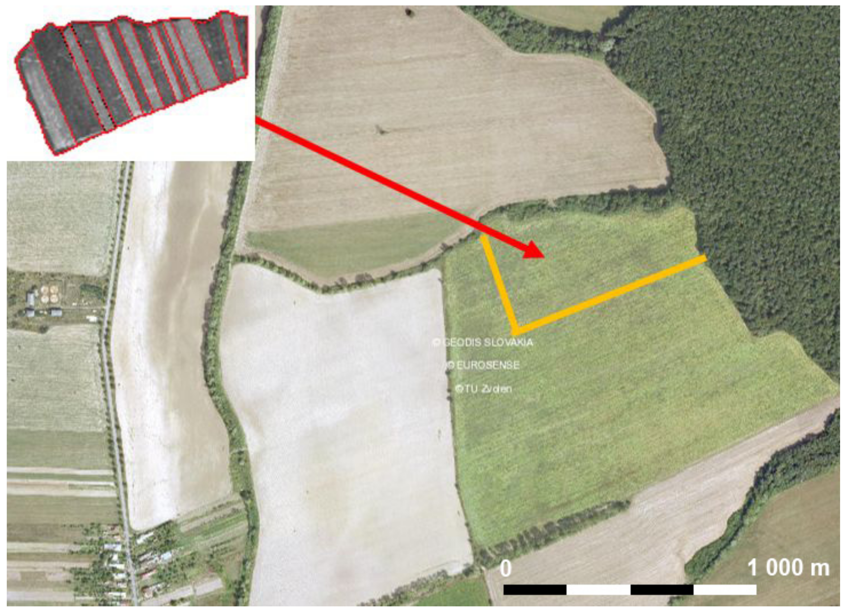
Figure 2 shows an example of a selected section (8.58 ha) of the current field (37.78 ha) in the area of interest, which consisted of 15 plots in the pre-aggregation (1950 state), the largest of which measured 232 m × 54 m (1.02 ha).
According to [
35], the first steps towards the creation of joint management within associations/societies in Slovakia occurred in the middle of the 19th century. After the onset of the totalitarian regime in 1948, a massive acclimatization took place, with the process itself being based on Act No. 69/1949 Coll. on UPC (Unified Peasant Cooperatives) [
36]. As stated in [
37], the establishment of the UPC led to the liquidation of private ownership. After the collapse of the totalitarian regime in 1989, the agricultural cooperatives were transformed [
38], but the large-scale nature of the fields remained intrinsically unchanged.
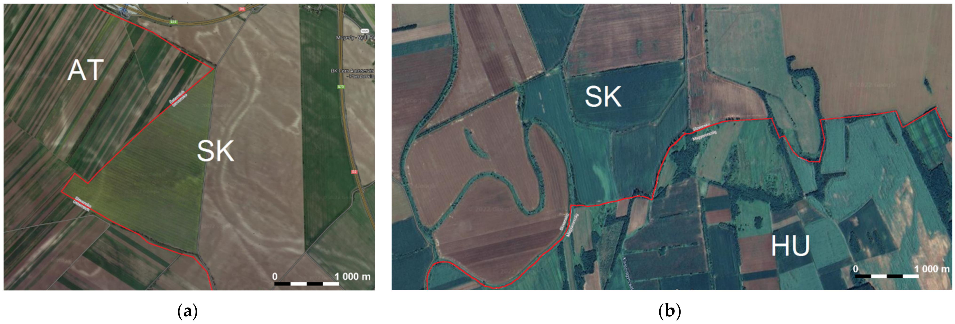
It is clear from previous research that the current form of the cultural, human-used rural landscape in Slovakia is related to the predominance of intensive farming, predominantly on an industrial scale, on large-scale fields, where monocultures of cereals, energy, and technical crops are grown. The orthophotos in
Figure 3 show examples of border areas, on the left SR (SK) and Austria (AT), area near the border crossing Bratislava-Jarovce/Kittsee (48.070883, 17.072833), on the right SR (East Slovakian Lowland) and Hungary (HU), near the village Malý Horeš (48.395207, 21.950210), where the difference in the structure or mosaic of the cultural landscape is obvious. While the picture on the left in Slovakia is dominated by a triangular field 1 km long with an area of 106 ha, in Austria it is a mosaic consisting of narrow fields up to 50 metres wide, which at the same length have an area of up to 5 ha. Similarly, the picture on the right shows fields on the Slovak side with an area of about 15 ha to 103 ha, just over the border in Hungary there are fields of about 1–10 ha, many bordered by small draws.
From the climatic point of view, eastern Slovakia is situated at the transition between the maritime and inland climate of Europe, with the continental influence prevailing. The intensity of solar radiation of the locality falling within the geological formation of the East Slovak Lowland exceeds the national average, as does the number of clear days per year or the highest annual temperatures. The vegetation in the monitored area is more thermophilic, the forest cover is oak and period-hornbeam, gradually changing into hornbeam-hornbeam in the foothills of the Vihorlat Mountains. Cultivated agricultural crops include wheat, oilseed rape, and maize.
3. Materials and Methods
Fragmentation proceeded in three stages/levels of division. Map bases were used:
In order to clarify the issues presented and the methods used in the context of broader interdisciplinary contexts, it is necessary to cite some related relevant sources that cover each aspect in more detail. The creation of maps based on modelling the spatial distribution of linear landscape features across Europe was elaborated in [
42]. Comprehensively worked out problems of image material analysis and overall photosciences are presented in [
43,
44,
45,
46]. From the point of view of biological corridors, this problem has been addressed in [
47]. The effects of the presence of selected linear features in the landscape on the presence of insects and their possibilities of the free movement were addressed in [
48]. Aspects of tourism in relation to landscape features were addressed in [
49] and in the context of insolation and heat load in [
50].
The issue of using military maps for the analysis of landscape features in the neighbouring Czech Republic with conditions analogous to the Slovak Republic has been described in [
51]. Possibilities of identification of these elements on the territory of the Slovak Republic were described in [
52], while in [
53] attention was focused on agricultural cultural landscapes. From the point of view of cultural landscape diversity and its varied composition, the issue was presented in [
54,
55]. The issue of water erosion and anti-erosion tillage in Slovakia was treated in [
56]. Areas of the condition of some selected localities of eastern Slovakia (Medzibodrožie) were dealt with in [
57].
As reported in [
58], information on the size of agricultural parcels in Slovakia is available from the LPIS (Land-parcel identification system), GSAA, and IACS (Integrated administration and control system) information systems, which keep records at the level of land parcels broken down by crops (LPIS) and also at the level of parcels (user hectares) with a specific crop grown, which have been declared by applicants for payments (GSAA, IACS).
As reported by [
59], according to GSAA and IACS, when considering the number of parcels below and above 30 ha in 2019, single-cropped parcels below 30 ha dominated (91% of the total number of parcels registered as arable land). However, the total area of single-crop parcels under 30 ha accounted for only 47% of the total area of declared arable land. Thus, up to 53% (706,600 ha) of the area of declared arable land in Slovakia is cultivated in units larger than 30 ha. Approximately 516,700 ha of arable land is cultivated in units of 50 ha or more.
The situation in the Czech Republic is mapped in sources [
60,
61]. According to the data published in [
62], from 2020 the condition of limiting monoculture cultivation to a maximum of 30 ha of continuous area (set by the Good Agricultural and Environmental Condition standard GAEC ((Good Agricultural and Environmental Condition), 7d) has been introduced. As reported by [
6,
63], the GAEC 7d standard requires that no more than 30 ha of arable land should be under continuous single cropping on an arable land block. A continuous area of a single crop within a section of a land block is defined as areas sown or planted with that crop that are not visibly separated from each other by a buffer zone sown with forage or crops approved for the buffer zone under Government Regulation No. As stated in [
6], in the German province of Rhineland-Palatinate, the local government also financially supports ‘non-productive’ green elements on arable land. Payments are linked to biodiversity indicators such as species diversity on the land. Fragmentation of agricultural land is also recommended by the FAO (Food and Agriculture Organization of the United Nations).
The area of interest was documented based on current satellite maps, topographic maps, and physical field reconnaissance. Parameters such as the size of individual monoculture fields (here based on GSAA and One Soil data), number of fields, crops grown, slope gradient (based on topographic maps), exposure to prevailing airflow (based on wind directional rosette data valid for the site and the presence of orographic effects), the presence of roads, watercourses, linear energy structures, and the presence of landscape features (trees, avenues of trees, trees, draws, uncultivated green belts, and permanent grassland).
The methods of retrospective analysis according to [
64] and the method of visual interpretation according to [
65] were used in the study of the historical map documents.
When delineating individual fields in the GSAA application, each delineated unit is associated with LPIS information, consisting of a field code, field area in hectares, site name, and classification by use. These data were used in the recording and processing of individual fields as well as the determination of their area.
The first step was based on map base 1 (Historical map from 1764), the origin and background of which are described in [
66]. Roads were identified—roads of different differentiated levels (carriage roads (historical name), roads in the floodplain, roads in the embankment, bridges (wooden/stone), and other landscape features/objects).
The polygon areas of the subdivided portions of the original fields, as well as the lengths of the subdivided sections, were surveyed using ZB-GIS [
67].
All identified roads were entered into the resulting map built on the map base from the google earth environment (satellite imagery). The part of the roads that led outside the currently existing roads (through the fields) represents the proposed dividing lines of the fields.
In the second step, the map base was used as a basis for map 2 (Orthophotomap from 1950). The roads—roads of different levels—were identified. Some of the identified roads were identical to the roads identified in the first step (intersection of the set of roads of Step I and Step II)), while some represented the set of new/additional dividing lines. The identified paths/dividing lines were entered into the map from Step I.
The maps that formed the basis for Steps I and II come from different historical periods. Some roads are found in both maps at the same time, others only in one or the other, or some roads may have partially changed their position, so two separate steps were followed.
The third step was based on the same map base 2, identifying the field boundaries from the pre-collectivization period, which also represented the access roads to each group of land/fields (dedicated or access roads). At this stage, only fields with an area of more than 30 ha were taken into account in the selection of the dividing lines (in some cases, re-division was necessary). In the selection of specific field boundaries, aspects related to soil erosion protection (especially slope gradient) were taken into account according to the mapping documents presenting the areas affected and threatened by water erosion [
68,
69]. Meanwhile, the area of interest generally falls within the area of medium risk of torrential rainfall and according to the exposure to wind flow. The average wind speed at the site at 10 m above the ground surface, according to [
65] is 3.8 ms
−1. The area of interest is located in the area of medium risk of torrential rainfall with a predominant southeast and north flow direction. According to [
70], the area of interest falls within an area of medium wind erosion hazard. When selecting possible dividing lines, those were chosen which led to the shortening of declining and open sections of fields in the sense of eliminating the LS factor (the influence of relief) according to the methodology for determining the real threat to the soil from water erosion processes, taking into account the current vegetation cover and the method of farming presented in [
71]. The selected identified roads were entered into the next map layer from step II.
The steps described result in three layers of maps capturing the cumulative fragmentation within each step.
Subsequently, parameters were evaluated for each level:
- -
the size of each field after fragmentation, frequency of fields, average field size, number of fragmented/number of newly created fields, and length of fragmentation lines (proposed).
- -
the degree of correspondence of roads from different historical periods, respectively.
For the proposed dividing lines, the alternatives of tree avenues (different tree species) and green belts were proposed. The design was based on the methodology of technical conditions of vegetation treatments for roads, according to [
72].
According to the different design proposals, the outputs were determined:
Biomass production (hay);
The amount of fixed carbon;
Shortening of declining water-erosion-prone sections of fields;
Shortening of open, exposed, wind-eroded sections of fields;
The number of bee colonies that can be fed;
The length of potentially usable routes for soft tourism, as defined in [
68,
69].
4. Results and Discussion
Based on the analysis of the map documents [
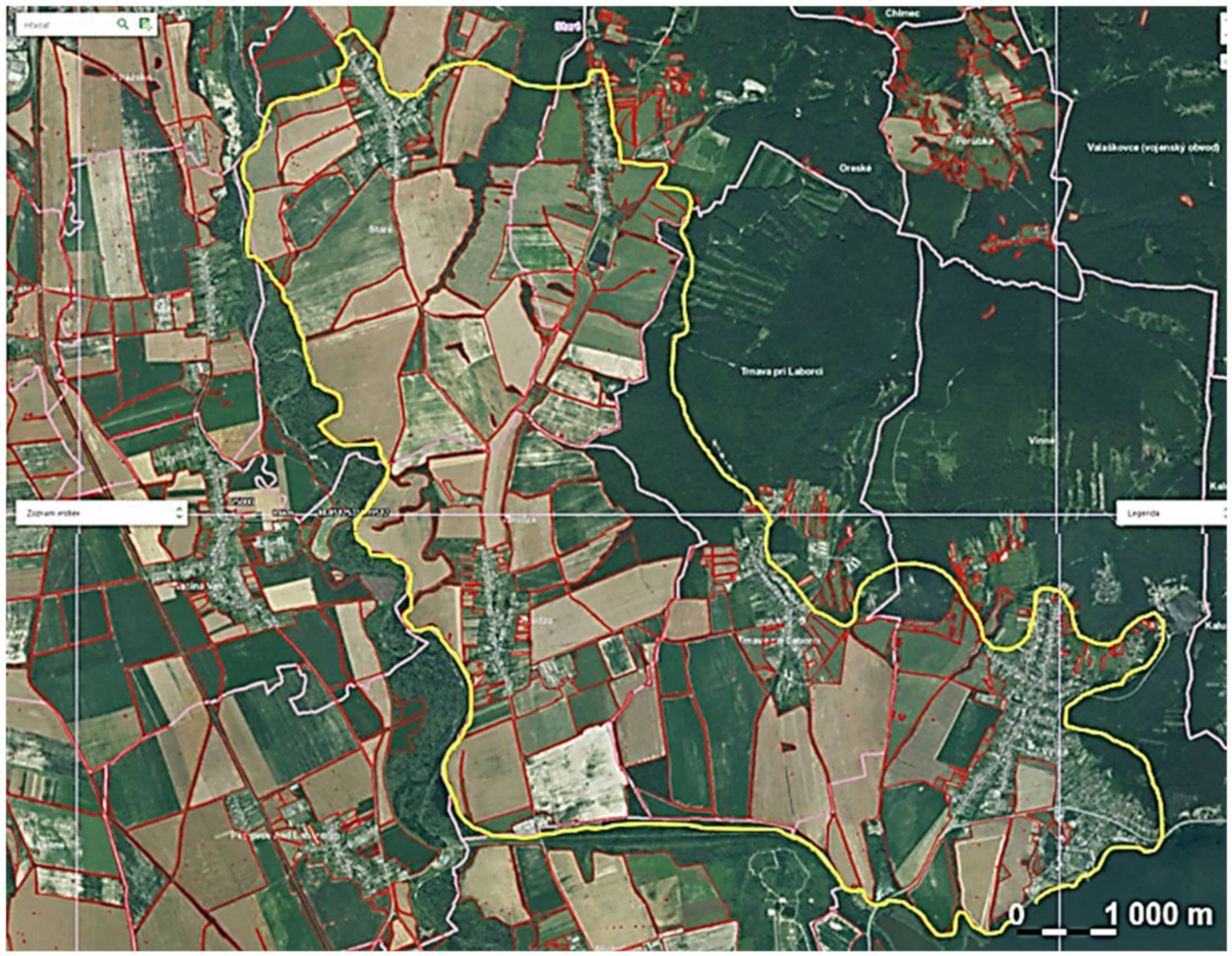
70] and the inspection, the detailed delimitation of the area of interest was proceeded by its delimitation by natural boundaries (the Laborec River, the Šírava Canal, and the bank of the Zemplínska Šírava water reservoir) and boundary lines leading along with dirt or forest roads so that the boundaries of the area of interest do not intersect the whole fields (
Figure 4). The area of interest thus defined has a total area of 4011 hectares, of which the area of agricultural land is 2769.41 hectares, with a total of 137 fields. In the figure, the boundaries of individual fields (single crop plots cultivated as a single unit) are plotted in red.
There are five villages in the area of interest, in whose intravilane there are 40 fields with an area ranging from 0.17 to 5.94 ha. These fields have not been subject to fragmentation and have not been taken into account in the subsequent solution. The fields in question do not constitute agricultural land used for industrial purposes.
If we do not take into account the fields located in the intramural area (allotments), the size of the area under analysis is 2731.71 hectares. There are 97 fields in this area, of which 32 have an area greater than 30 ha. The individual parameters relating to the part of the area of interest subject to the analysis are given in
Table 1.
The recording of individual fields was based on the LPIS designation. In this way, it is possible to identify each field individually on the map as well as assign additional attributes as required.
In a first step, 15 roads with a total length of 35,354 km were identified in the map documents from the first military mapping of 1764–1787.
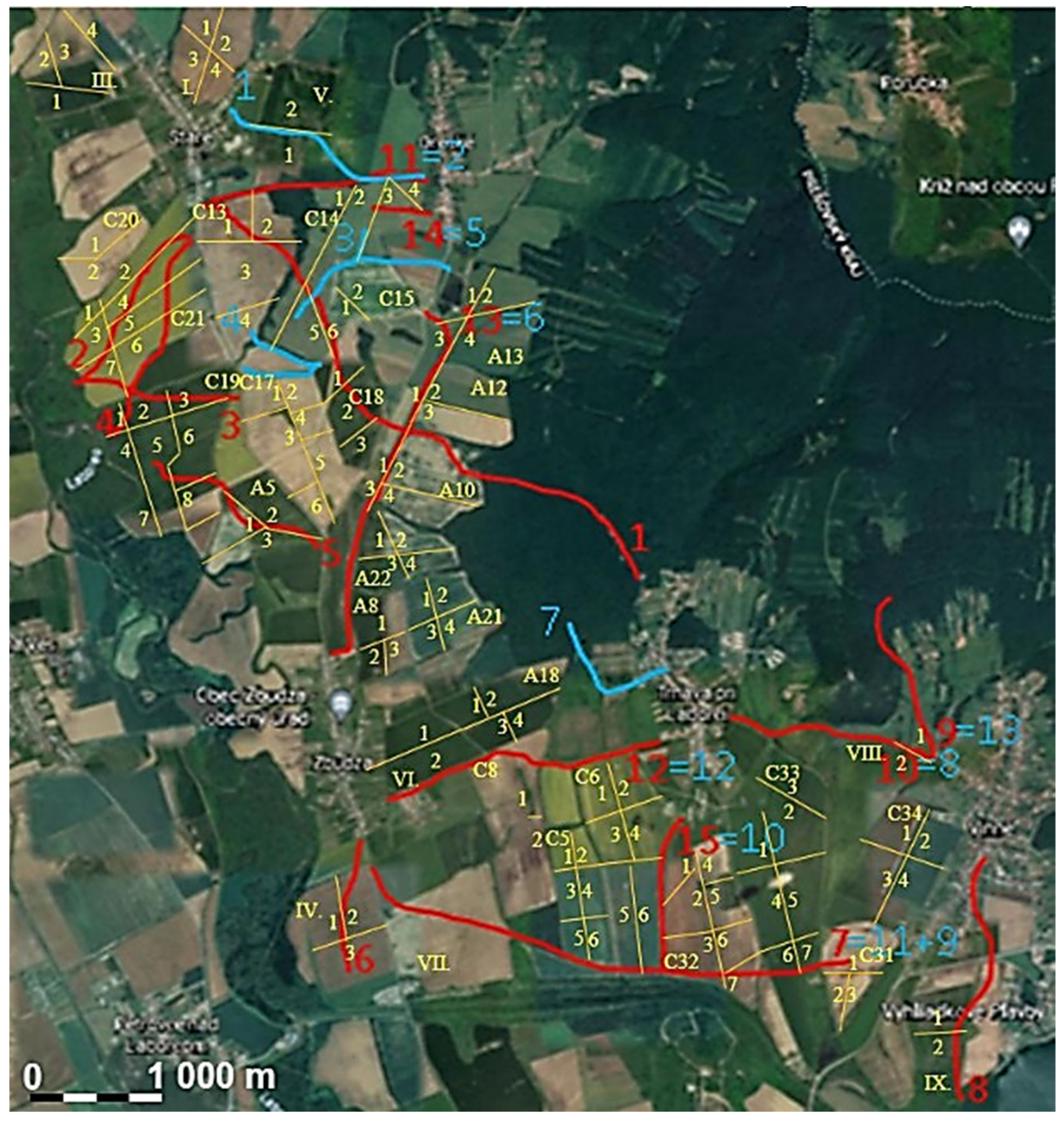
Figure 5 shows the routes/dividing lines of all three levels of subdivision. The markings are as follows: first level—red, second level—blue, and third level—yellow; the sections marked XY=AB are the intersection of the first and second levels of division, i.e., these road sections/dividing lines can be found in both map documents. In the first level of division, 17 fields have been divided.
In the second step, 13 roads with a total length of 5904 km were identified in the 1950 orthophoto map.
In a third step, 28 field access roads/field block boundaries with a total length of 15,079 km were identified in the 1950 orthophoto maps.
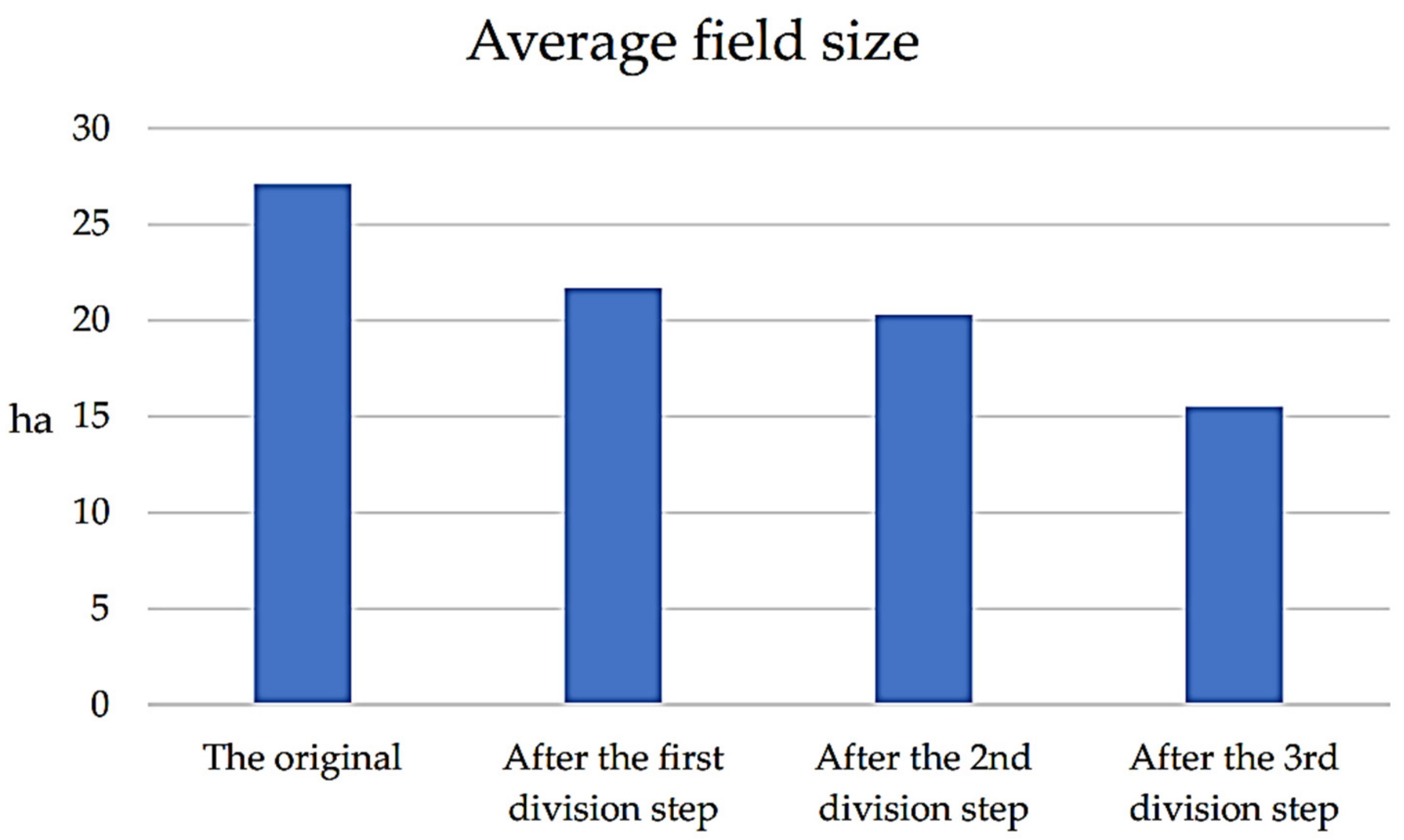
Figure 6 shows a graphical representation of the average field size at the beginning and after each fragmentation step.
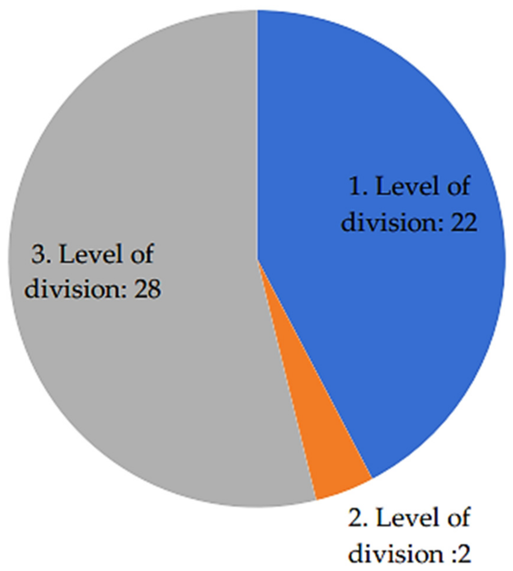
In the first step, 17 fields with a total area of 1083.56 ha were divided, in the second step were 2 fields with a total area of 77.39 ha, and the third step had 13 fields with a total area of 631.34 ha. The number of newly created fields was 44, 4, and 49, respectively. The number of fields above 30 ha was 15 after the first step, 13 after the second step, and 0 after the third step (
Figure 7).
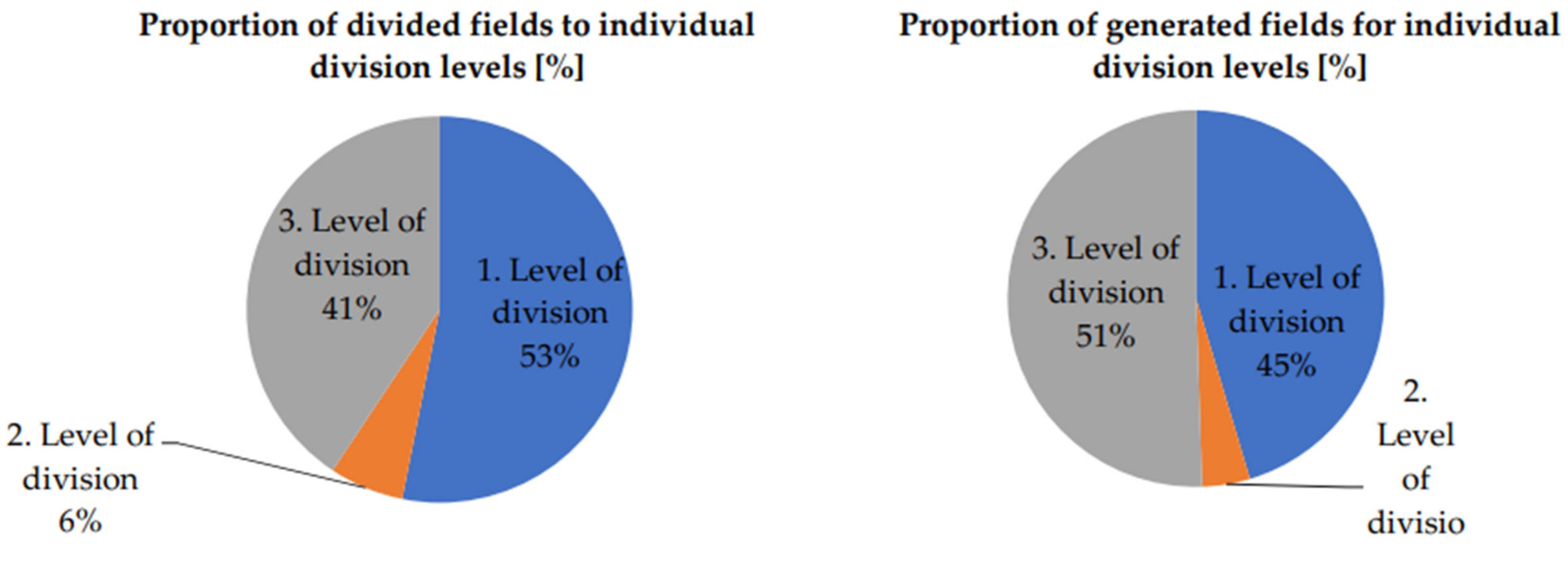
The share of the divided fields for the individual division levels and the share of the resulting fields for the individual division levels expressed as a percentage are shown in the graphs in
Figure 8.
As some sections of the roads identified within each subdivision step were identical to the field boundaries, they did not represent new subdivision lines in those locations; therefore, the total lengths of the subdivision lines are less than the lengths of the individual roads carried over from the original mapping documents.
The total length of the dividing lines was 16,109 km after the first subdivision step, 1868 km after the second subdivision step, and 15,079 km after the third subdivision step. The number of dividing lines per division step is shown graphically in
Figure 9.
The proportion of roads that match in the maps from both periods, i.e., from the first and second steps, represents 45.9% of the total length of the identified roads. In the third step, only the division lines based on field boundaries and off-road access roads from steps one and two were considered.
Based on the results in the form of the length of the dividing lines, it was considered to use them in the form of green belts with a width of 22 m according to [
71]. The areas of green belts that can be sown with meadow vegetation according to [
72] in the individual steps are as follows: for step I, 23.3 ha; for step II, 3.2 ha; and for step III, 33 ha. If meadow vegetation is considered, the biomass obtained can be used energetically as an input to a biogas plant or non-energetically as livestock feed. In terms of botanical composition, regional grass–herb mixtures are suitable. As reported by [
68], their high species richness and higher representation of herbs at the expense of grasses are advantageous for overall biodiversity enhancement. The biological value of sown grassland supports the diversity of animals that are tied to the presence of herbs, especially insects. According to [
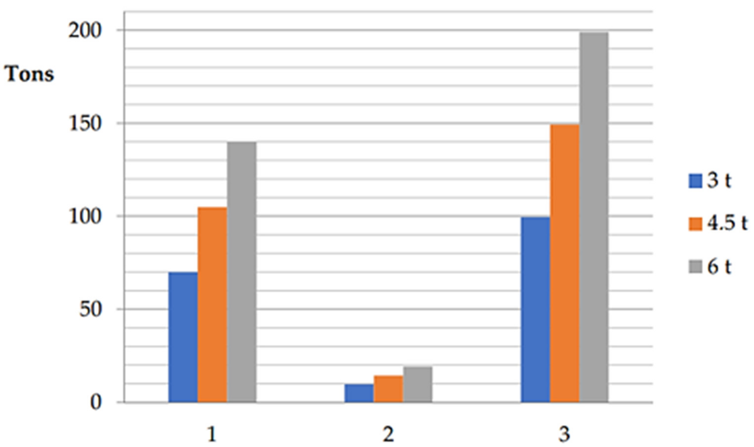
68], it is possible to obtain 3.5 to 6 tons of hay per hectare, depending on the crop (with or without fertilization). For a total area of 59.67 ha, it is then possible to obtain from 179.01 to 358.02 tons of hay (268 t on average). The share attributable to the individual stages of division is shown graphically in
Figure 10.
If the planting of woody plants, i.e., shrubs and trees, is considered, taking into account the climatic conditions and species composition in the locality, it is possible to consider shrubs mainly with hawthorn, and trees mainly with deciduous trees—summer oak, apple tree (wild species), and horse chestnut [
65]. Single or multi-row strips of trees and shrubs could be used as windbreaks, with multiple layers of shrubs and trees from the ground to the tops of the trees. When using vegetation as windbreaks, care should be taken to situate them perpendicular to the direction of the prevailing winds.
The total number of shrubs up to 3 m in height at a stub of 3 m is 54,333. For shrubs up to 1.5 m tall at 1.5 m height and 1.5 m clamp, the figure is 108,669, and 163,002 at 1 m clamp. For a single line planting of trees in the 8−6 m buffer, the number is 6792 to 9056. For a double line—double-sided avenue around the road—this amounts to between 13,584 and 18,112 pcs at the same spacing. For a triple line, which can be placed in a 22 m wide strip, the number of trees will be from 20,376 to 27,168. According to [
65], such planting in a 22 m wide green belt (a planting of shrubs and trees) can act as a protection for agricultural land against wind and soil erosion, depending on the conditions.
From the point of view of obtaining grazing for pollinators, especially bees, one colony per 10 ha can be considered according to local conditions [
69], which represents a total of six bee colonies.
From the point of view of carbon sequestration in the wood mass on the area obtained in the defragmentation process, according to [
70], it is possible to consider carbon sequestration of 0.41 t of carbon per tree, which represents a total of 2784.7 to 11,138.8 tons of carbon sequestered gradually and in the long term in the wood mass. In terms of carbon sequestration, the further design will also need to take into account the benefits in terms of carbon sequestered in the soil, not only in the green belts but also in the adjacent field margins, which will be affected by factors increasing the proportion of humus in the soil. This corresponds well with the data published in [
71], which states that there are about 75 billion tons of soil organic carbon stored in the EU, with EU CO
2 production in 2017 of 4.5 billion tons.
When planting or implementing greenery in green belts of dividing lines, care must be taken to eliminate invasive species, such as Solidago sp. (goldenrod) and Reynoutria sp. (syn. Fallopia sp.—wingwort), among others, which could lead to silting up of surrounding fields and make it more difficult to replant desirable native/natural species.
When protecting against water erosion, priority was given to running the dividing lines perpendicular to the recession line to shorten long recession sections of fields, especially in the north-eastern part of the area of interest, on the foothills of the Vihorlat Mountains. A significant part of the protection against topsoil runoff or protection against leaching of the humus component from the soil is due to the fact that, according to [
72], the old (historical) roads were deliberately routed in the landscape usually along straight, often elevated routes that drain well, avoid muddy sections, etc. At the same time, these roads were routed to minimize the effort and exertion involved in traversing the elevation (both upwards and downwards), from the perspective of man and beasts of burden.
The dividing lines in the western, open part of the area of interest were designed to eliminate mainly north and south-easterly wind flow in this part of the area by dividing the sections in the NE–SW direction.
The implementation and further design of the specific form of the dividing strips will have to take into account the demands of the existing farming equipment (the use of the so-called wide-harvesting equipment is questionable), the working and transport requirements, and the connectivity and transport accessibility of all the fields. From the farmer’s or operator’s point of view, such a fragmented landscape may incur additional fuel costs as well as an increase in the time required for the work (number of passes and downtime). These aspects will also have to be taken into account and adequately analysed and reflected in the forthcoming legislation.
The design of the dividing lines in relation to the correct addition of woody vegetation, such as trees and shrubs, protects these features, which are also areas of ecological interest, from being ploughed back by agricultural machinery.
From a contemporary point of view, with the decline of large-scale tourism and the desire to move towards local soft forms, an important part of the proposal is the creation of a network of hiking trails—routes that can serve both to improve accessibility to landmarks in the countryside (e.g., cairns, noble graves, and Lake Vinné), but also as a rich network of variously routed interconnected paths for recreation/recreation in the countryside itself.
Table 2 shows the lengths of the different hiking trails that were created in the first and second steps of the fragmentation process.
The analogically conceived problem of fragmentation of the cultural landscape, i.e., agricultural land in Slopensko, was also presented in the case study “Land Use in the Dropie Protected Area” published by the Institute of Environmental Policy of the Ministry of the Environment of the Slovak Republic as part of a broader study [
6]. The average area of the fields in the locality was 40.5 ha.
A method of dividing a selected area in the south of Western Slovakia on the border with Austria was proposed, whereby the creation of sections of grass or woody greenery in unproductive strips or the creation of dirt roads was considered. The primary tool for fragmentation was not the routing of roads and their use in the design of dividing lines, but the division of large units into smaller ones and their subsequent structuring with green elements. The area under consideration was a relatively small unit with no villages and no major through roads (border area), and it was also a bird area, so the objectives pursued were different. Last but not least, the differences between the two approaches were also related to the fact that, in the case of the Dropie Protected Area, it was a specific area—a protected bird area—and the following aspects, according to [
6], were prioritized to reduce the value of the acreage of the fields and to increase the diversity of the crops grown, where 70% of the area of agricultural land in 2017 consisted of the two crops maize and wheat.
5. Conclusions
The proposed method of fragmentation of the cultural landscape mainly made up of large-scale fields of agricultural land is based primarily on two steps of restoration of historical roads and subsequent thickening of the network of dividing lines by restoring the boundaries of field blocks/access roads to these fields from the past. This method demonstrated the possibility of using the former infrastructure in the landscape and thus the possibility of respecting the historical and natural factors in solving the current environmental problems associated with the impacts of climate change and decades of intensive industrial farming in the cultural landscape of the Slovak countryside. At the same time, the proposed method of fragmentation leads to a homogeneously distributed network of dividing lines that are interconnected and can create a transport infrastructure useful both for access to agricultural land and for promoting local soft tourism in the place of residence of the inhabitants. In principle, such soft tourism is not oriented towards creating an alternative use of the landscape from agricultural production towards recreational or leisure use, but creates another more fully fledged parallel use of the landscape. The relevance of the above is linked to the trend in recent years to strengthen local tourism, which does not require travelling, thus putting a strain on the transport infrastructure. Such tourism serves the local (national) population or the population of the surrounding area, which is mostly accessible without the use of motorised means of transport, i.e., by bicycle and on foot. Its basic premise is a positive perception of the immediate surroundings and at the same time the creation of the necessary network of communications, without the need to implement additional elements, burdening the environment and creating the need for additional services. Last but not least, the recreational function implemented in the landscape reinforces the relationship between man and the environment and its protection. The productive function of such a fragmented rural landscape can remain paramount and can thus take on a more sustainable and climate-resilient form.
An important element of the proposal is the combination of dividing lines based on native roads and green belts with meadows, small woods, or woody vegetation with cumulative functions in terms of biomass production (e.g., hay), grazing for pollinators, erosion control, and overall improvement of ecosystem diversity. Important potential benefits, taking into account how green areas are created in the sense of [
6], are protection against solar radiation; protection against wind; psychological and aesthetic effects; creation of variability in the landscape; and an insulating role (background for animals). Hygienic benefits are noise mitigation; dust reduction; and reduction in exposure to emissions. The results of the solution may provide a basis for the preparation of a future legislative framework, and it will be necessary to extend the research to include aspects falling within the field of landscape biology, taking into account its prospective development. This is particularly the case for respecting the components of nature and landscape protection, national park protection zones, landscape conservation zones, hygiene, aesthetics, and climatic conditions of the landscape. Property and legal issues, which go beyond the scope of the authors’ coverage of the presented problem, will also be an integral part of the solution.
In favour of the above is the fact that the method of fragmentation, based on the restoration of historically justified dividing lines, largely respects the distribution of the ownership structure of the land, which has evolved in an analogous way, respecting a similar mechanism to the creation of parcel boundaries. From this point of view, it is possible to expect a coincidence between, on the one hand, the process of fragmentation of fields and, on the other hand, the consolidation of fragmented plots in terms of their ownership, which is a problem that needs to be solved in order to be able to apply the forthcoming legislative changes effectively in practice.
The presented work showed that many substantial parts of the main dividing lines have their basis in ancient history, represented in this case by a historical map from 1764 (First Military Mapping). These remained preserved until the period of collectivization in the mid-20th century, documented by an orthophoto map from 1950. This was reflected in the predominance of the first step of division over the second, where there were only a small number of “new paths”. An important factor here is the connection to the municipality and other infrastructure, which has been preserved in the form of historical and technical monuments. The possibility of multiple fragmentations of large-scale fields was brought about by the third step of division, based on the original “pre-collectivization” structure of the country. What is important is the interconnectedness between all the steps of division, which gives them spatial and temporal continuity. The presented results can be, among other things, an important basis for further processing of layers in the GIS environment, as another part of existing services and applications.


