Systematic Review

The Vehicle-Routing Problem with Satellites Utilization: A Systematic Review of the Literature

by
Raúl Soto-Concha
1,2,*,
John Willmer Escobar
3,
Daniel Morillo-Torres
4 and
Rodrigo Linfati
5,*
1
Facultad de Ingeniería, Universidad del Bío-Bío, Concepcion 4051381, Chile
2
Departamento de Ciencias de la Ingeniería, Universidad de Los Lagos, Puerto Montt 5480000, Chile
3
Accounting and Finance Department, Universidad del Valle, Cali 760001, Colombia
4
Department of Civil and Industrial Engineering, Faculty of Engineering and Sciences, Pontificia Universidad Javeriana Cali, Cali 760031, Colombia
5
Departamento de Ingeniería Industrial, Universidad del Bío-Bío, Concepcion 4051381, Chile
*
Authors to whom correspondence should be addressed.
Mathematics 2025, 13(7), 1092; https://doi.org/10.3390/math13071092
Submission received: 3 March 2025 / Revised: 20 March 2025 / Accepted: 24 March 2025 / Published: 26 March 2025

Abstract

:
The Vehicle-Routing Problem (VRP) represents a critical challenge in logistics, encompassing numerous variations, such as time window considerations, multi-depot systems, two-echelon routing aspects, and Satellite Locations (SL). SLs are intermediate facilities that support cross-docking, storage, and transshipment operations. However, inconsistencies in defining “satellite” have hindered precise research and implementation. This study presents a systematic review of the use of satellites for VRP, employing the PRISMA methodology to ensure a comprehensive and reproducible analysis. The findings indicate that about 50% of the reviewed papers include a path-splitting variant. At the same time, there is a notable gap in addressing random demands and pickup and delivery within cross-docking environments. A major limitation is the lack of a well-known public dataset, as about 50% of the datasets are created or adapted for specific studies. Additionally, the analysis reveals significant gaps in dataset standardization and the integration of dynamic routing under uncertainty. These findings underscore the potential of satellite-based systems to optimize urban logistics and supply chains while pointing to critical avenues for future research.

1. Introduction

The transportation problem of products in last mile logistics is crucial, primarily due to increased delivery volumes, sustainability considerations, costs, service level [1], an aging workforce, and new challenges posed by technological advancements such as autonomous driving, drones, and delivery robots [2]. This problem belongs to the family of the Vehicle-Routing Problem (VRP) [3], which plays a significant role in supply chain management (SCM). The VRP is introduced by Dantzigs work titled Truck Dispatching Problem (TDP) [4], and according to the best-known algorithms, the VRP is considered NP-Hard [5].
According to Mor and Speranza [6], in VRPs the decisions must be made regarding the assignment of customers to vehicles and the sequence of visits, and additional decisions must be performed collectively, depending on the specific problem framework. For instance, ref. [7] addresses dynamic routing with stochastic requests, a critical aspect in e-commerce, while ref. [8] includes the multi-depot, capacity, and two-echelon Vehicle-Routing-Problem issue (2E-MDCVRP).
It is essential for the supply chain to address all aspects that satisfy customers’ orders [9], especially those related to urban logistics, which involves transportation activities [10], including deliveries in urban areas [11]. One of the elements to consider in delivering products to customers is the use of satellites, which are often defined as intermediate facilities [12], which can have storage capacity [13] or may serve for cross-docking operations [14]. Additionally, these facilities can be fixed [15,16] or mobile [17,18] (see Figure 1). The satellite locations [19,20] are defined as an intermediate site with limited, or even non-existent, storage capacity [21], or as a physical space equipped for load transshipment and consolidation [22], when used as a keyword in string search engines for scientific papers associated with VRPs.
The issue with using the keyword “satellite” in search strings is that the term is not solely associated with transport problems but also with Low-Earth Orbit (LEO) satellite networks [23], such as in the study by [24], which utilizes the Ant Colony Optimization (ACO) to solve the traffic imbalance problem in some high-demand internet links. Another example is the research by [25], which uses the satellite concept to optimize data collection in satellite systems.
Recent reviews, such as those presented by [26], present a literature review related to the two-echelon Vehicle-Routing Problem (2E-VRP), focusing on dividing distribution networks into two echelons, using different vehicles at each echelon to achieve economies of scale and meet specific constraints. On the other hand, ref. [27] focuses on research into 2E-VRP that combines ground vehicles (GVs) and drones (UAVs), emphasizing connection mechanisms between the two echelons, such as synchronization at satellites and flexible coupling/decoupling between UAVs and GVs.
In this study, we propose a systematic review to address the Vehicle-Routing Problem with the use of satellites, providing a guide on applying this concept and contributing to existing VRP-related reviews not previously explored. Our study considers the use of satellites and their different categories based on their node capacities, location types, or the particular use of the term. The statement follows the Preferred Reporting Items for Systematic Reviews and Meta-Analysis (PRISMA) [28], enabling an analysis of the most common problems and recurring solution methods.
The paper is organized as follows: Section 2 describes the materials and methods used to perform the review using the PRISMA guidelines. Section 3 shows the obtained results and provides some gaps related to the literature review. Section 4 and Section 5 develop discussions and conclusions.

2. Materials and Methods

This research includes developing a systematic literature review. The guidelines described in PRISMA have been used to ensure a methodological framework for this review. According to [28], the use of PRISMA guidelines was considered by over 60,000 papers as of August 2020 [29]. Furthermore, between 2020 and 2023, review-type papers based on PRIMA methodology exceeded 20,000 in the Web of Science database alone (verified via search string TS = (PRISMA)).
Following this methodology and the literature that applied it to its systematic reviews, the following steps have been conducted:
  • Research Questions
  • Search Strategy
  • Selection and Evaluation Process
  • Analysis and Synthesis

2.1. Research Questions

Two research questions were formulated to guide the review and meet the review’s objectives:
Q1. How is the concept of “satellites” defined in the Vehicle-Routing Problem (VRP) context, what are the patterns in the use of the keyword “satellite”, and what are the inconsistencies in different research studies?
Q2. What are the challenges and future research directions?

2.2. Search Strategy

The search strategy for collecting papers related to the research topic focused on using the keyword satellites in VRP. A combination of keywords with Boolean logic operators was configured (see Figure 2). The search targeted papers from the last five years (2019–2023), including those from January to June 2024, and was limited to peer-reviewed papers from the Web of Science and Scopus databases. The use of these databases ensures that our literature review is grounded in a robust foundation, encompassing diverse and reliable relevant sources.
The keyword “Satel*” was used to include research with terms like “satellite”, “satellite”, or similar, contributing to the topic.

2.3. Selection and Evaluation Process

According to the established criteria, only peer-reviewed papers published in English were included due to the universal nature of the language. The publishing timeframe was also limited, considering only papers published in the last five years, from 2019 to June 2024. This temporal selection aims to capture the most recent and relevant research, ensuring an up-to-date state of the art. Additionally, only studies incorporating the term “satellite” in their research were considered, ensuring a focused analysis of this specific aspect of the VRP. Table 1 presents the detailed inclusion criteria used in this selection process. These criteria were designed to ensure consistency and objectivity in identifying the most pertinent and suitable papers for the systematic review.

2.4. Analysis and Synthesis

The selected papers were analyzed based on the research questions. Additionally, the variants of each classification, publications by year, and solution methods were analyzed to address the first research question. The database search on Web of Science and Scopus retrieved 2593 records. Figure 3 shows the PRISMA 2020 flow diagram [28]. As shown in Figure 3, the search was followed by identification, selection, and inclusion. In the selection stage, the inclusion criteria from Table 2 were applied to filter scientific papers related to the topic.
The selection process involved two steps:
  • Removing duplicate DOIs found in WoS and Scopus reduced the dataset to 1486 publications.
  • By using titles, abstracts, and keywords, a second filter was applied based on the exclusion criteria presented in Table 2.
After applying the exclusion criteria, 62 papers remained for classification. One of the exclusion criteria for the analysis is the inability to access the publication.
Inclusion criteria were established to ensure consistency and objectivity in identifying the most relevant studies. In the Scopus and Web of Science (WoS) databases, the search string indicated in Figure 2 was used, retrieving 2953 papers from both sources combined. Then, only peer-reviewed journal articles published in English between 2019 and June 2024 (the date the search was conducted) were considered, as detailed in Table 1.
The selection process was carried out in two main stages. First, duplicate DOIs found in Web of Science and Scopus were removed, reducing the dataset to 1486 publications. Then, a second filtering phase was applied based on titles, abstracts, and keywords, using the exclusion criteria defined in Table 2. The review focused on studies on the Vehicle-Routing Problem with satellite utilization, ensuring that the term “satellite” was explicitly linked to a VRP variant, reducing the selection to 73 papers.
Finally, additional exclusion criteria were applied, such as using the term “satellite” in a non-VRP context, retracted papers, and publications without full access, among others, resulting in a final selection of 62 relevant articles.
Table 3 summarizes the selection process stages and the exact number of excluded articles at each step.

3. Results

According to the first research question associated with the keyword “satellite”, the analyzed papers can be categorized into the following categories:
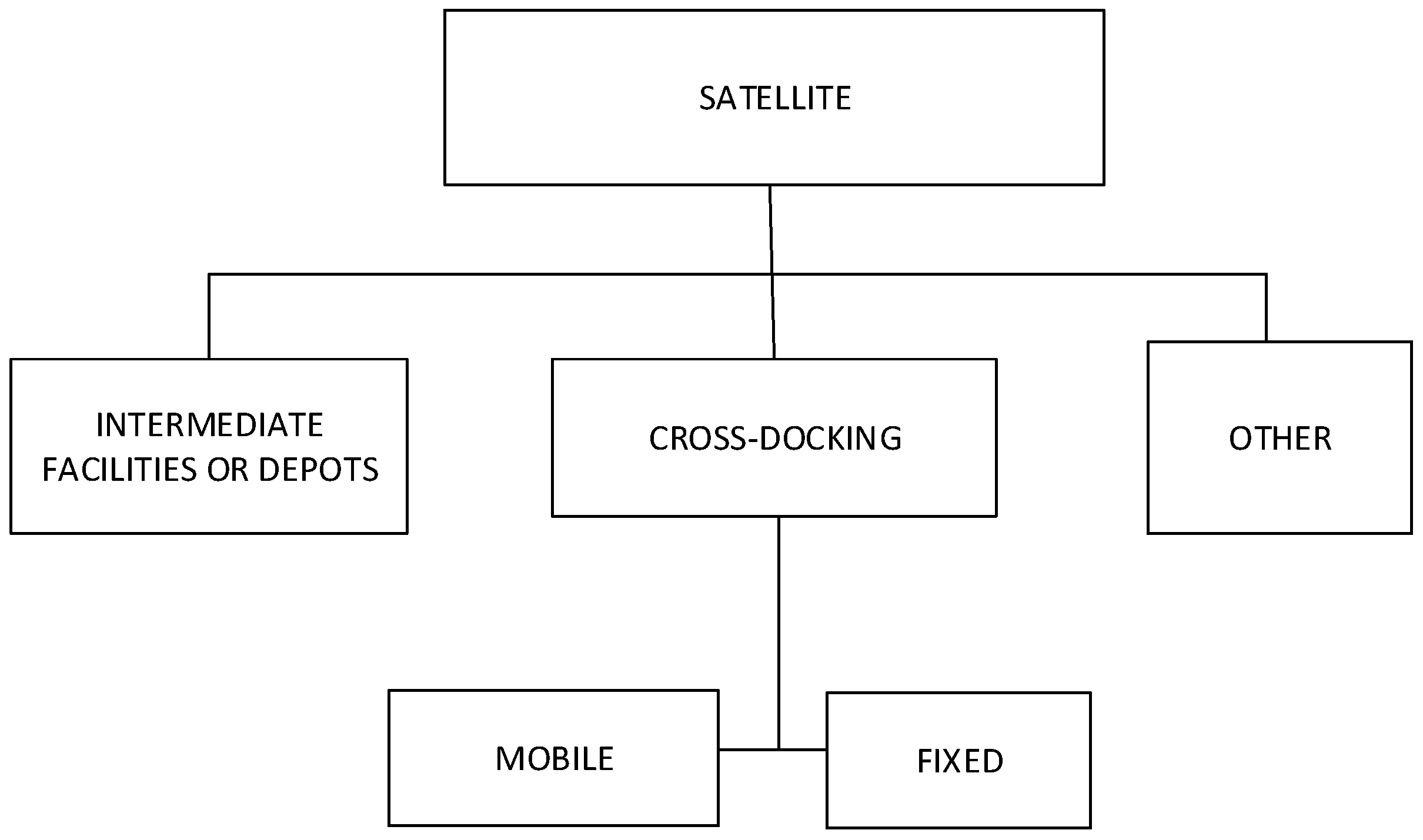
Intermediate Depots: Intermediate locations for transferring products with capacity for unloading, vehicle replenishment, and storage [19], which can be fixed [13] or mobile [18]. For example, ref. [13] uses parcel lockers as fixed intermediate depots where customers can pick up their goods. In the case of mobile depots, ref. [30] uses parking lots as mobile storage satellites for exchanging containers.
Cross-Docking: Locations without storage capacity, designed for transferring products from one vehicle to another [19], which can be divided into the following subcategories:
Fixed Sites: Stations located in areas not equipped for transshipment activities, as exemplified by using a gas station parking lot for product exchange between vehicles [31].
Mobile Sites: Delivery points without storage capacity, exemplified by vehicle locations where parcels can be transferred between them [32].
Satellite Depots: A set of locations where trailers can be detached and products can be transferred between trucks and trailers [33]. Vehicles transporting smaller vehicles are also included in this category, such as [34], which describes a parked van serving as a launch point for drones to make deliveries.
Satellite Customers: A customer that can be served while the primary vehicle performs an action, either through an alternative means of transport or by a person, such as a customer that can be visited “on foot” while the vehicle is recharging [35].
Within these categories, the following variants were identified:
Path Level (o Step): The problem involves two echelons of routing: first, designing routes from depots to a subset of satellites, and second, routing from the satellites to serve customers [36].
Location: Involves opening specific depots, assigning customers to the open depots, and designing vehicle routes from the depots to the customers [37].
Trailer Transfer: Applies to a fleet of trucks and trailers with capacity available to serve a set of customers [38].
Electromobility: Use of electric vehicles with zero-emission energy [39].
Temporal Synchronization: Coordination of vehicle arrival times at satellites [40].
Multi Trip: The ability to make multiple trips to visit customers from a satellite, deliver goods, and return empty to the satellite to start another journey or finish at the depot [41].
Multi-depots: Considers two (or more) depots for deliveries [42].
Pickup and Delivery: Customers with both pickup and delivery demands, where vehicles must deliver goods to customers, pick up other goods, or perform both [43].
Random demands: Dynamic or suddenly growing demands [18,44].
Time Constraints: Classic time restrictions (time windows) or synchronization constraints [45].
Delivery Options: All customers can be served directly or through nearby coverage locations, with the decision made by the distributor [13] or other options ([46]).
In Table 4, the complete classification of each article included in this study, organized by category and variant, can be found:
Next, each of the articles indicated in the table will be described according to the use of the keyword satellite:

3.1. Description of Articles

3.1.1. Intermediate Depots or Facilities

In ref. [47], the capacitated 2E-VRP (2E-CVRP) is presented, where satellites act as “intermediate depots”, aiming to minimize delivery costs while considering vehicle capacity and satellite locations. The authors introduce a route-based formulation without flow variables and new constraints for flow balancing at satellites and propose an improved branch-cut-and-price (BCP) algorithm with a novel branching strategy. This approach solves instances with up to 200 customers and 10 satellites, generating new instances with up to 300 customers and 15 satellites. Conversely, ref. [48] addresses the 2E-CVRP using a matheuristic based on the “cluster-first route-second” approach, applying it to instances ranging from 21 to 200 customers, 3 to 200 vehicles in the first echelon, 4 to 1026 vehicles in the second echelon, and 4 to 10 satellites.
Meanwhile, ref. [49] tackles the 2E-VRP using an embedded Hamiltonian graph and proposes the EHG-HA heuristic algorithm based on two schemes: initialization with Hamiltonian graphs and dynamic satellite adjustment. This approach applies to instances ranging from 21 to 200 customers, 2 to 10 satellites, 2 to 5 vehicles in the first echelon, and 4 to 100 vehicles in the second. In ref. [50], the 2E-VRP is studied in e-commerce, where vans travel from the depot to the satellites, and motorcycles deliver from satellites to customers. K-means clustering and the 2-opt algorithm optimize routes in instances with 100 customers, 10 satellites, and 2 to 10 clusters. Similarly, ref. [51] introduces the 2EVRP with Transshipment Nodes and Occasional Drivers (2EVRP-TN-OD), which includes OD to reduce operational costs. The problem is formulated as a mixed-integer nonlinear programming (MINLP) and solved for instances ranging from 1 depot, 2 satellites, and 12 customers to 1 depot, 4 satellites, and 50 customers.
Noteworthy are the different algorithms used to address the 2E-VRP in these studies, including exact techniques like BCP in [47], heuristics such as EHG-HA in [49], clustering in [50], and occasional drivers in [51], applied to scenarios with varying instance sizes and configurations.
The following studies focus on the 2E-VRPTW variants. In ref. [15], route costs are minimized using a Branch and Price (BP) algorithm applied to instances with up to 100 customers and 5 satellites. In contrast, ref. [52] introduces the two-echelon emergency Vehicle-Routing Problem with time window assignment (2E-EVRPTWA) in the context of supply distribution during the COVID-19 outbreak in Chongqing, China. They use tri-objective mixed-integer programming (MIP) and develop a multi-objective adaptive large neighborhood search with a split algorithm (MOALNS-SA) to optimize operational costs and delivery times, solving instances with 30 to 60 customers (the number of satellites is not specified). Ref. [53] addresses the e-order fulfillment problem (EOFP), focusing on minimizing costs and meeting time windows by assigning orders to fulfillment centers (satellites). They use a mixed-integer linear programming (MILP) model and a decomposition-based approach with a greedy heuristic and adaptive large neighborhood search (ALNS). This approach is applied to instances with 4–8 distribution centers and 20–400 customers. Ref. [54] presents the 2E-VRP with time constraints (2E-TVRP), solving time-constrained routes using a MILP model, a savings algorithm, and variable neighborhood search (VNS) for realistic instances with up to 23 satellites and 1008 customers.
Ref. [55] introduces the 2E-VRP with direct deliveries and access TW (2E-VRPDDATW), where heavy trucks’ access to urban areas is restricted. They propose a MILP and ALNS, solving instances ranging from 1 depot, 3 satellites, and 15 customers to 6 depots, 5 satellites, and 100 customers.
In the research on 2E-VRP with Simultaneous Pickups and Deliveries (2E-VRPSDP), ref. [56] solves instances with up to 200 customers and 10 satellites using VNS. Ref. [57] studies the 2E-VRPSPD to minimize the total travel distance using a hybrid heuristic called KNN_ALNS, which combines the K-Nearest Neighborhood algorithm (KNN) and ALNS. In this approach, customers are first assigned to satellites using KNN, initial routes’ solutions are generated, and, finally, ALNS is applied to improve them. The instances considered range from 60 customers and 2 satellites to 100 customers and 5 satellites. It should be noted that [56] uses VNS to solve larger instances than [57].
For its part, ref. [43] addresses the 2E-VRP with grouping constraints and simultaneous pickup and delivery (2E-VRPGS), where a vehicle from the same satellite must serve customers within the same administrative region, adding a dimension of geographic and grouping constraints. The goal is to minimize operating costs while satisfying the capacity constraints of vehicles and satellites. The authors propose a path-based model and BCP with a novel dominance rule in the labeling algorithm and customized valid inequalities. The instances solved range from 20 customers and 2 satellites to 100 customers and 10 satellites.
Ref. [58] addresses the 2E-VRPTW with simultaneous pickup and delivery (2E-VRPTWSPD), using satellites as intermediate depots to receive products from the central depot, deliver them to customers, collect orders, and send them back to the depot. The authors propose an MIP formulation and variable neighborhood tabu search, applying dummy satellites and time windows to speed up the search. Computational tests with exact algorithms were performed with instances of 7 to 12 customers and 2 satellites, while the heuristic was tested on instances with up to 200 customers and 10 satellites.
Ref. [59] aims to minimize travel times and fuel consumption to reduce vehicle pollution, addressing the two-echelon pollution-routing problem with simultaneous pickup and delivery by considering multiple time windows (2E-PRPSPD-MTW). In the first echelon, vehicles deliver and pick up goods at satellites, and in the second echelon, the fleet moves from the satellites to the customers. The authors use the multi-objective VNS (MOVNS) algorithm, solving instances with up to 100 customers and five satellites.
Another variant to analyze is the use of bicycles for deliveries, where ref. [60] addresses the large-scale bike sharing repositioning problem (BSRP) and designs optimal routes from the central depot to satellite stations and then to customer stations. The objective is to minimize transportation and inventory costs, adapting a 3E-VRP structure for the BSRP and incorporating a fuzzy clustering strategy and a fuzzy correlation-based adaptive VNS (FC-AVNS) algorithm. In this work, instances ranging from 100 to 519 with a fleet of 3 to 8 vehicles with variable capacities have been used to test the performance of the approach.
For its part, ref. [13] studies the 2E-VRP with covering options (2E-VRP-CO), in which the first echelon involves deliveries from a central depot to satellites and coverage points, such as parcel lockers, where customers pick up their products. In the second echelon, products are distributed from the satellites to the customers using cargo bicycles. The authors propose a MIP model and use an ALNS to solve instances with up to 101 nodes, 5 bicycles, and 10 satellites.
Ref. [30] present a 2E-CVRP that combines vans and bicycles, introducing the concept of standard containers and integrating trams and decentralized satellites. However, unlike previous studies, the intermediate depots are mobile, offering a distinct approach. The study evaluates various scenarios, such as tram–bike systems with standard containers and consolidation centers, designing a flexible model to optimize distribution in urban systems. This study introduces a modified multi-start heuristic algorithm considering the costs incurred in both echelons after each allocation. The algorithm operates in three phases: initial clustering, clustering improvement through local search, and iterative reassignment of customers to satellites using a multi-start approach that adjusts assignments based on capacity and costs in both echelons. The research varies in both methodologies and the size of the instances solved: Ref. [60] applies fuzzy clustering to instances with up to 519 stations without specifying the number of satellites; Ref. [13] uses bicycles and lockers in instances with up to 101 nodes and 10 satellites; whereas ref. [30] focuses on more complex models, incorporating multiple combinations of vehicles and scenarios, given the mobile nature of depots, proposing a more sophisticated heuristic algorithm for different logistical configurations.
Regarding the use of electric vehicles, ref. [61] presents a 2E-VRP with recharge stations, where automated guided vehicles (AGVs) must recharge during their routes to maintain continuous operation. The main objective is to minimize total operating costs and maximize the routing efficiency of the AGVs. The authors propose a mathematical model and solve it using a combination of the Arbitrary Insertion Algorithm (AI) together with a Genetic Algorithm (GA) and Hill Climbing Algorithm Improving (HC). The solved instances include between 48 and 96 customers, with 10 satellites and 4 vehicles, demonstrating the viability of the proposed approach across different logistics network sizes.
On the other hand, ref. [62] presents a 2E-VRP with electric vehicles, time windows, and battery-swapping stations (2E-EVRPTW-BSS), where the fleet includes internal combustion vehicles (ICVs) in the first echelon and electric vehicles (EVs) in the second echelon. Unlike [61], this work integrates the coordination between vehicles of different technologies, proposing a mixed-fleet scheme that ensures synchronization of the arrival times of ICVs at the satellites. The solved instances with VNS are larger, with up to 200 customers, 10 satellites, and 40 battery-swapping stations (BSS), making it more applicable to urban scenarios.
Similarly, ref. [63] addresses the 2E-EVRP by adding time windows (2E-EVRP-TW), where the primary objective is to minimize transportation costs. The proposed solution combines MILP with the Clarke and Wrights algorithm (CW) to generate initial solutions, followed by VNS improvement. While it shares the cost optimization goal with [61,63] focuses on an urban setting where satellites are located in the surrounding areas of cities, solving instances ranging from 5 customers and 2 satellites to 100 customers and 21 satellites.
In turn, ref. [20] uses fossil fuel vehicles in the first echelon to transport goods from the depot to the satellites, while EVs are employed in the second echelon. This study focuses on minimizing transportation costs, considering the charging needs of EVs, and proposes a scheme BP with an arc flow model decomposed into an integer master problem to derive lower bounds and a pricing subproblem. The instances addressed here are smaller than [61], solving up to 20 customers, 2 satellites, and 2 recharge stations.
Other variants used in conjunction with 2E-VRP include multi-depot systems. For example, ref. [46] tackles the multi-depot two-echelon Vehicle-Routing Problem with delivery options (MDTEVRP-DOs), designing routes from multiple depots to satellites and, subsequently, from these satellites to customers. The objective is to optimize routes using simulated annealing (SA) metaheuristic, considering capacity and work time constraints. The solved instances range from 1 depot, 4 satellite stations, 10 pickup points, and 50 customers to 3 depots, 12 satellite stations, 30 pickup points, and 200 customers, reflecting its capability to manage logistics networks of various sizes with multiple delivery options.
Refs. [40,42] present complementary approaches. Ref. [42] focuses on the 2E-VRP with multi-depot fuel minimizing (MD2E-FMRP), aiming to minimize fuel consumption with a heterogeneous fleet. For this purpose, they propose a MIP formulation and use driving cycles simulating speed variations, allowing vehicles to return to any satellite. Tests include up to 56 nodes, and ALNS proved more efficient in time than Gurobi in solving the problem within the time limit of 10,000 s.
Meanwhile, ref. [40] introduces the Multi-Commodity Two-Echelon Vehicle-Routing Problem with Satellite Synchronization (MC-2E-VRPSS), which combines depots and satellites in a fleet synchronization environment. The authors develop an MIP and ALNS to solve instances ranging from 5 customers and 2 satellites to 275 customers and 19 satellites, standing out for its ability to handle multiple products and the need for synchronization between echelons of the logistics system.
In contrast, the studies by [18,64,65] explore other aspects of the 2E-VRP with intermediate facilities (2E-VRPTW-IF). Ref. [65] addresses the 2E-VRPTW-IF-OD, which introduces intermediate facilities such as parcel lockers or transshipment nodes. This study employs a MILP model and a Hybrid ALNS (HALNS), solving instances with up to 50 customers, 4 satellites, and 8 transshipment nodes, adding logistical complexity. Ref. [64] focuses on enhancing the efficiency and sustainability of the parcel distribution network by optimizing satellite locations, conducting experiments with real-world instances in Paris, France, and evaluating sustainability using performance indicators such as equivalent carbon dioxide emissions, among others. They use unsupervised machine learning to assign delivery points to satellites and a nearest-neighbor (NN)-based algorithm to design second-echelon routes, solving instances with up to 50 customers and 4 satellites. Finally, ref. [18] proposes the two-echelon dynamic Vehicle-Routing Problem with proactive satellite stations (2E-DVRP-PSSs), where trucks first serve static customers and proactive satellite stations (PSSs), while light vehicles handle dynamic demand. To solve the problem in small instances, the authors use cutting planes and, for large instances, a hybrid algorithm that combines improved GA and tabu search (GA-TS), highlighting the ability to respond to dynamic demands in real-time.
The multi-trip 2E-MTVRP is another relevant variant. Ref. [41] addresses the 2E-VRPTW, utilizing satellites for loading and unloading between echelons. This study aims to minimize operational and transportation costs. To solve the problem, they first formulate a MILP and solve it using BCP, incorporating column generation and a cut enumeration procedure for elementary routes adapted for multiple trips. Instances solved include 6 distribution centers, 5 satellites, 100 customers for single trips, and 8 satellites with 100 customers for multiple trips.
Ref. [19] introduces the 2E-MTVRP with capacitated satellites and reverse flows (2E-MTVRP-CSRF). The goal is to propose and evaluate a solution algorithm for the problem. The authors developed a matheuristic, formulating a refined MILP and optimizing the routes using each echelon’s large neighborhood search (LNS) algorithm. They also verify solution feasibility through low-complexity tests. Instances used include 50 customers, 1 vehicle in the first echelon, 5 vehicles in the second echelon, and 2, 4, or 8 satellites; for instances with 100 customers, there are 2 vehicles in the first echelon and 10 in the second echelon, with the same number of satellites as in the 50-customer instance.
Ref. [44] presents the 2E-VRP with demand blowout (2E-VRPDB). The solution proposes a hybrid fireworks algorithm (HFWA), combining the optimal cutting algorithm (OCA) with an improved fireworks algorithm (IFWA), where a strategy called time-division distribution (TDD) is first implemented to mitigate demand pressure. Instances range from 22 to 51 customers, 4 to 5 vehicles, and up to 10 satellites (vehicles and satellites are not specified in detail).
LRP is also present as an additional two-echelon variant (2E-LRP). Ref. [68] proposes the 2E-LRP with recommended satellites (2E-LRPRS), which can be reoptimized. To solve this problem, the authors formulate an MILP and a BP. Solved instances contain between 60 and 129 customers, 4 to 18 vehicles, and 4 to 10 satellites. Ref. [69] addresses the 2E-LRPSPD, presenting a MILP. To solve the problem, they formulate a MILP and a Branch and Cut (BC) to obtain solutions for medium-sized instances. They use Iterated Local Search and VNS-based metaheuristic algorithms (ILS-VNS) and a VNS, where ILS-VNS provides initial solutions for the BC, and VNS improves each branching. Instances range from 25 to 200 customers, 5 to 10 satellites, vehicle capacities of 750 and 850 in the first echelon, and 100 and 150 in the second echelon.
Ref. [66] addresses the multi-modal last mile system as a 2E-LRP with mixed vehicles and mixed satellites (2E-LRP-MVMS), motivated by the e-grocery distribution industry. It incorporates parcel lockers (satellites) and autonomous delivery robots (ADRs). The objective is to optimize the locations of depots and satellites, the number of parcels delivered, and the routes in the two echelons to minimize costs and carbon emissions. They formulate a distribution network combining vans, parcel lockers, and robots. To solve this problem, a hybrid immune algorithm (HIA) is introduced, solving instances with 2 to 12 depots, 3 to 16 satellites, 7 to 26 customers, 2 to 9 vans, and 2 to 7 ADRs.
In the UAV variant, ref. [67] aims to minimize transportation costs and emissions in a distribution network for e-grocery distribution, utilizing autonomous delivery vehicles (ADVs). The authors formulate a 2E-VRP with mixed vehicles (2E-VRP-MV) with a nonlinear objective function. The proposed solution algorithm is a two-step clustering-based hybrid GA and Particle Swarm Optimization (C-GA-PSO). In the solution, customers are clustered at satellites (intermediate depots) based on minimum distance and maximized demand. Experiments were conducted with up to 100 customers.

3.1.2. Cross-Docking—Fixed

Cross-docking is the direct transfer of products from inbound vehicles to delivery vehicles without intermediate storage [86], which can occur at fixed points in specific locations. In cross-docking with fixed satellites, the 2E-VRP variant predominates. In [70], a 2E-VRP with stochastic travel time is solved using simheuristics, a combination of simulation and optimization. Satellites are referred to as Urban Consolidation Centers (UCCs) before final delivery to customers. To solve the routing, they used an algorithm based on the Nearest Neighbor Procedure, applied to real data from a delivery company in Paris, involving 90,627 deliveries of 4 depots with 5 satellites each. This study is notable for incorporating stochastic travel time from a triangular distribution.
Ref. [71] integrate production into the 2E-VRP with cross-docking satellites (2E-PRPCS), which, unlike other studies, determines daily production, the number of deliveries from depot to satellites and satellites to customers, as well as network routes, achieving a good balance between production and routing. Satellites act as intermediate points for cargo transfer between vehicles. The authors formulate an MILP and design a BC algorithm and a matheuristic to obtain initial solutions, solving instances with 10 to 35 customers, 2 to 3 satellites, and 4 or 6 satellite vehicles.
On the other hand, ref. [31] addresses the 2E-VRP with Fixed Fleet Heterogeneous (2E-HVRP), where vehicles must stop at intermediate points—gas stations in this case—before delivering products. They use an efficient island-based memetic algorithm with a local search procedure based on the Lin–Kernighan heuristic (IBMA-LK), testing their approach on instances with 50 to 125 customers and 20 to 30 satellites.
Refs. [72,73] add TW to the 2E-VRP (2E-VRPTW). Ref. [72] develops an exact branch-price-and-cut (BPC) algorithm. In this approach, satellites serve as points where high-capacity vehicles transfer goods to lower-capacity vehicles for final customer delivery. They use a two-path formulation (2E-2P) to solve instances with 15 to 100 customers, 2 to 6 depots, and 3 to 5 satellites.
In contrast, ref. [73] presents the last mile delivery problem with scheduled lines (LMDPSL), which leverages the unused capacity of an established public transportation system. Satellites are dedicated stations in this transportation network where vehicles collect goods for final delivery, adding time windows and intermediate replenishment. A BPC is developed and evaluated on instances with 50, 100, and 150 customers and allows the exact and heuristic solution of the LMDPSL.
Ref. [14] introduces the 2E-VRP with satellite bi-synchronization (2E-VRP-SBS), where satellites function as transshipment points to consolidate and transfer loads between trucks from different echelons. The problem is solved using a mixed-integer programming model with CPLEX and a modified ALNS (mALNS) in instances with up to 17 origin satellites, 17 destination satellites, and 120 customers per satellite.
Meanwhile, ref. [8] developed a 2E-MDCVRP model for e-commerce applications with a two-stage solution process. In the first stage, satellites are positioned as centroids in the clusters using the k-Means algorithm to form k-cluster sets, and the Repetitive Nearest Neighbor algorithm is employed to determine travel routes in the second echelon. In the second stage, the trial-and-error method establishes routing schedules in the first echelon. Although the abstract mentions that satellites travel to the customers, the problem development clarifies that vehicles travel from satellites to customers.
Ref. [16] introduces the 2E-CVRP with Swap Containers (2E-CVRPSCs), where satellites serve as transfer points between vans and bicycles. They develop a mathematical formulation with asymmetric distance matrices for bicycles and a Parallelized LNS (PLNS) heuristic, evaluated on instances ranging from 21 to 300 customers with 2 to 15 satellites, though the number of vehicles used in the instances is not specified. They also incorporated grouping to make the instances more realistic.
For LRP studies, ref. [74] proposes an innovative Two Echelons Location Routing Problem (2E-LRP) model that incorporates temporal synchronization of vehicles at satellites (2E-CLRPVS), applied to the Greater Montreal area. Satellites act as transfer points between vehicles from different echelons, and the model penalizes waiting times using a Binary Variable Fixing (BVF) method. Instances involve 10 to 99 customers, 5 satellites, 2 distribution centers, and homogeneous fleets per echelon, though the final fleet is heterogeneous, with 4 to 10 vehicles in the first echelon and 10 or 15 in the second echelon. This study has the advantage of being a real-world application.
In contrast, ref. [75] examines the Two-Echelon Multi-Attribute Location-Routing Problem with fleet Synchronization at intermediate facilities (2E-MALRPS), which includes multicommodity demand, time windows for deliveries, capacity constraints at satellites, and fleet synchronization between echelons. The authors present an MIP model solved using a dynamic discretization discovery (DDD)-based algorithm and a hybrid formulation, where nodes representing facilities are duplicated in each period, while customer nodes appear only in relevant periods. Instances range from 5 to 50 origin-to-destination demands, with 3 to 5 satellites and up to 6 potential platforms.
Comparing the two studies, ref. [74] focuses primarily on vehicle synchronization with penalties for waiting times at satellites, while ref. [75] expands the problem to include multicommodity demand and additional constraints like time windows and limited satellite capacity, offering a more complex and multidimensional approach than [74].
For UAV studies, ref. [85] designs a plan for transporting products from distribution centers on the city’s periphery to satellites (transshipment points) within the city using a mixed fleet of autonomous and manual vehicles. This problem is termed the service network design problem with mixed autonomous fleets (SNDMAFs). The authors formulate an integer program (IP) and develop a custom algorithm, DDD-SNDMAF, which enhances the DDD framework to provide optimal solutions for the SNDMAF. Instances involve 5 external zones, 4 of which have 1 depot, 6 to 9 satellites, and 18 to 24 products, while the fifth zone has 2 depots, 8 satellites, and 18 to 27 products. This study incorporates mixed fleets of autonomous and manual vehicles in an urban environment, representing a significant advancement in transport network planning for smart cities and addressing the challenge of integrating new technologies into urban logistics.

3.1.3. Cross-Docking—Mobile

Ref. [17] addresses the 2E-MTVRP with a dynamic satellite (2E-MTVRPDS), incorporating collection and dynamic information usage. Here, satellites are mobile intermediate points in fragmented agricultural fields, enabling efficient grain harvesting and transport coordination. This study introduces multiple trips in the first echelon and employs a Memetic Algorithm (MA) combining a GA and a Local Search Procedure (LSP) to solve the problem. Instances include between 50 and 225 farmlands, 6 harvesters, and up to 6 trips. Ref. [22] introduces a two-echelon city logistics system with on-street satellites (2E-CLS-OS), employing VNS and CW to optimize initial routes, tested on instances with up to 900 customers and 30 satellites.
Studies [79,80] tackle 2E-VRP logistics problems with different approaches and satellite configurations. Ref. [79] proposes a Graph-Based Fuzzy Evolutionary Algorithm (GFEA) to handle the 2E-VRP by assigning satellites to customers using fuzzy operators and optimizing routes on instances of up to 200 customers and 10 satellites. In contrast, ref. [80] introduces the 2E-CVRP with Sharing Satellite Resources (2E-CVRPSSR), solving smaller instances (up to 50 customers and 5 satellites) with a MILP and ALNS approach. While ref. [22] focuses on real-time route optimization with on-street satellites, and [79] innovates with evolutionary learning, ref. [80] optimizes shared satellite use for goods consolidation. All three studies target the 2E-VRP.
Ref. [32] introduces variants with mobile satellites, time windows, and intermediate multi-depots in a last mile delivery system, utilizing multiple local depots and multi-modal delivery options. Satellites are temporary on-street locations where vehicles can transfer packages to each other or bicycles. This novel approach introduces mobility and operational flexibility. The study formulates a mathematical model and develops a two-phase heuristic: a constructive phase that uses biased randomization to incrementally build solutions by cost-ranked random selection and an improvement phase optimizing solutions with local search techniques such as two-opt and cut-and-insert. Instances span 50 to 440 customers with 5 to 17 satellites, distinguishing this approach through its mobile satellite applications and time-window optimization.
Ref. [76] focuses on integrating Interval Travel Times (ITTs) into the VRP, optimizing routes between satellites and a central distribution center (CDC). Satellites, in this case, are fixed but temporary transfer points that improve efficiency by accounting for traffic-induced travel time variations. The LANTIME metaheuristic solves this problem. Instances are based on real traffic data from cities like Stuttgart and New York, with 37 and 24 satellites, respectively, reflecting a traffic-optimized fixed approach.
Unlike [76], which solely addresses the 2E-VRP with ITT, both refs. [77,78] incorporate mobile satellite usage. In ref. [77], the model extends to the two-echelon city dispatching model with mobile satellites (2ECD-MS) by introducing crowd-shipping (2ECD-MS-CS). Satellites are trucks transporting goods from a distribution center, and crowd-shipping responds to fast delivery demands with time windows. The algorithm is a Multi-Directional Evolutionary Algorithm (MDEA), and instances range from 50 to 200 customers with up to 10 mobile satellites. Conversely, ref. [78] presents the 2ECD-MS with trucks dispatching directly (2ECD-MS-TDD), where satellite trucks reposition daily based on customer demand. VNS optimizes routes for up to 200 customers and 10 mobile satellites, differing from [77] by employing daily repositioning of mobile depots.

3.1.4. Satellite Depots

An important variant in this category is the TTRP, as addressed by [38], where the authors tackle the capacitated TTRP (CTTRP). In this study, satellites act as depots for cargo transfers, and the authors propose a two-commodity flow formulation along with a BC algorithm to model the flow of goods transported by trucks with and without trailers. The solved instances include up to 50 customers, 30 served by trucks, 2 to 4 trailers, and up to 7 available trucks. In contrast, ref. [81] focuses on the extended single TTRP (XSTTRP), developing a hybrid metaheuristic, AVXS, applicable to other routing problems. This solution involves phases of assignment, construction of an initial solution, and improvement, considering satellites as points where trailers are temporarily parked while trucks serve customers. The instances range between 21 and 145 customers, 5 to 116 parking spots, and between 6 and 21 satellites. Comparatively, ref. [38] presents a more specific approach with stricter capacity constraints, while [81] offers a more general and flexible solution for a larger number of customers and satellites.
In ref. [82], the authors introduce the Profitable Single TTRPTW (PSTTRPTW), which incorporates capacity constraints, time windows, and customer accessibility. In this case, satellites serve as depots where trailers can be decoupled from trucks. To address the problem, the authors formulate an Integer Programming (IP) model and develop a BC algorithm, solving instances with 9 to 46 customers and 1 to 6 satellites. Conversely, ref. [83] explores the Truck-Drone Routing Problem with Time Windows (TDRP-TW), where satellites are customer locations acting as drone launch and recovery points. The authors employ a BPC with an ALNS, named ALNS-BPC, solving small- and medium-sized instances with up to 50 customers and larger ones with 100 customers. It should be noted that [83] introduced drones operating from launch points on truck routes to the TDRP-TW, providing flexibility by including air transport from customer locations as satellites.
In ref. [12], the authors propose a novel variant of the 2E-LRP-MS, where fixed satellites are replaced by first-level vehicles (CT) acting as mobile satellites, supplying second-level vehicles (CF) during delivery routes. They use the heuristic Clustering-Based Simultaneous Neighborhood Search (CSNS), combined with K-means for clustering and selecting consolidation points (CP), prioritized through Fitness Proportionate Selection (FPS). Generated routes are optimized using four local search algorithms (Self-insert, Self-swap, Peer-insert, Peer-swap). Solved instances include 20 to 200 customers, 5 to 10 trips from the central depot, and 5 to 10 consolidation points. This study introduces mobile satellites, providing greater flexibility for in-route replenishment and revolutionizing the satellite concept by making them mobile, allowing for a more dynamic and adaptable approach to last mile logistics.
In ref. [34], the authors introduce the 2E-VRP with Time Windows and Mobile Satellites (2E-VRP-TM), incorporating TW constraints and synchronization of mobile satellites. In this case, satellites are vans transporting Unmanned Aerial Vehicles (UAVs). To solve the problem, they developed a mathematical formulation and an ALNS. However, they did not directly test the model but evaluated ALNS effectiveness in 21 instances, solving problems with 100 customers, up to 5 satellites, and 33 UAVs. This study emphasizes synchronization between vans as mobile satellites and drones, unlike [83], which utilizes drones launched from fixed points.

3.1.5. Satellite Customers

In ref. [35], the authors present the Electric-Vehicle-Routing Problem with Time Windows and Satellite Customers (E-VRPTWsc), which introduces the possibility of an electric vehicle visiting customers using an alternative mode of transport while recharging at a station. In this context, satellites are defined as customers who can be served by an alternative mode of transport during the vehicle’s charging time, optimizing this period. The authors propose a mathematical model and an Iterated Local Search (ILS) metaheuristic reinforced by Variable Neighborhood Descent (VND) and Set Partitioning. Instances consider up to 100 customers, between 2 and 18 vehicles, and up to 15 satellite customers.
In ref. [84], the authors present the Truck and Unmanned Vehicles Routing Problem with Time Windows (TUVRP-TW), where satellites are the customers. Trucks dispatch or collect Unmanned Vehicles (UVs), which can serve one customer and be picked up at another, introducing a synchronization element. To address the problem, they formulate a mathematical model and apply a hybrid approach using GRASP to generate initial solutions, which are then improved through VNS. Solved instances are based on Solomon’s classic VRPTW problems, accommodating up to 100 customers, with up to 75% served by UVs. This study stands out in terms of integrating autonomous vehicles into last mile logistics.

3.2. Used Instances

Below is an analysis of the instances used in the research, classified based on whether they were obtained from existing literature in the available databases, adapted from literature to address the presented problem, or created by the authors. The analysis includes information on frequency and percentage of use and the authors who utilized them. This aims to provide a clear and structured overview of the utilization of these instances in the studied context.

3.2.1. Literature Instances

The analysis of the instances, as show in the Table 5, reveals that their usage frequency and distribution across the reviewed studies show a clear trend. The most utilized instance is [87], with 5 appearances (5.95%). This is followed by [88,89], each with 4 uses (4.76% each).
These three instances account for 15.48% of the total, making them the most representative in the research field. A significant portion of the instances is used only once, representing 1.19% of the total for each. This highlights a high dispersion in the selection of instances and low repetition across the studies.
This distribution suggests that while some instances stand out as more frequently used, the selection of instances in the studies is highly dispersed. The low repetition indicates a lack of consensus within the research community on which instances are the most relevant or representative, which could impact the comparability and reproducibility of results in this field.

3.2.2. Adapted Instances

The analysis of the instances, as show in the Table 6, reveals a dispersion in their usage, as most (80%) are used in only one study, representing 1.19% each. Refs. [15,98] stand out with adaptations in three studies each (3.57%), while [87,102] appear in two studies (2.38%). These four instances account for only 11.9% of the total, reflecting the relevance of [98] and the interest in [15] as a recent instance.
It is worth noting that instance [87] is used in seven studies, either in its original form or adapted, followed by instance [15] with six studies, instance [89] with five uses, and instances [88,98] with four each, representing 10.45%, 8.96%, 7.46%, and 5.97%, respectively, of the total instances referenced in these investigations (67).
Instance adaptations are made due to the lack of directly applicable test cases, requiring the addition of parameters or modifications based on the context. For example, ref. [34] based its experiments for the 2E-VRP-TM on the instances from [98], introducing random modifications to parameters such as the load capacity of VUACs, UACs, and TW. Additionally, random changes were made to the demand of VUACs and UACs, and the time windows. Service times were also included.

3.2.3. Created Instances

Among the created instances as show in the Table 7, ref. [15] stands out, as since its creation, it has been used in five different studies, both as the original instance without adaptation [41,55,72] and in adapted versions [55,58,75]. Additionally, it is important to note that ref. [55] uses [15]’s instances in their experiments, both in the original and adapted forms. Now, with seven occurrences, ref. [87] becomes the most frequently used instance (five original and two adapted).

3.2.4. Accessibility of Instances and Trend in VRP Research with Satellites

This section reveals that, among the instances presented in the research, various difficulties are observed in their articles. The first difficulty arises in the works of [8,50], which do not specify whether they created the instances or if they come from the literature. On the other hand, ref. [30] mentions that their instances were created from a real case but do not provide further details. Refs. [61,66,70,76] indicate that their instances are created but only present the dataset parameters. Other studies with difficulties include [44,77], which provide access to their datasets but are inaccessible. Finally, ref. [74] falls into a separate category, as access to the dataset is only possible through a request to the authors.
Regarding the trend of VRP investigations that use satellites, they have increased from 2019 to the date of inclusion of articles, as shown in Figure 4:
The graph shows a growing interest in VRP (Vehicle-Routing Problem) research involving satellite use, as evidenced by an increase in publications starting in 2022. Although 2024 shows a lower count, it is presumed that this figure may rise, given that the cut-off for this review was in June 2024.
Figure 5 presents an analysis of the distribution of the 62 papers selected according to the criteria. This classification provides insight into the main publication sources contributing to VRP research using satellites.
The analysis shows that the European Journal of Operational Research and Computers & Industrial Engineering are the most frequent sources, with six articles each. Transportation Science, Transportation Research Part B, and Expert Systems with Applications have four articles each. It should be noted that 20 articles belong to different journals, each with a frequency of one, which are grouped in the “Other” category.
Figure 6 analyzes the distribution of solution methods used in the 62 selected papers. This classification provides an overview of the predominant approaches applied to the VRP with Satellite Utilization.
The analysis of Figure 6 reveals that trajectory-based metaheuristics are the most widely used approach, appearing in 31 articles, highlighting its effectiveness in solving this type of problem. Exact methods are applied in 13 articles, demonstrating their relevance despite their computational limitations for large-scale cases. Hybrid methods are used in 8 articles, and heuristics appear in 5. Population-based metaheuristics are used in 4 articles, showing a minor presence. Finally, matheuristic methods are the least common, appearing in only one study.

4. Discussion

Before starting this section, it is important to highlight that the limitations of this study are primarily defined by the exclusive inclusion of peer-reviewed papers published in English between 2019 and June 2024. While this ensures the review’s relevance, it excludes research published in other languages. Additionally, the search was restricted to the Scopus and Web of Science databases, leaving out studies from other sources, such as doctoral dissertations, due to the lack of open access. The selection was also limited to research explicitly using the term “satellite” about a VRP variant, excluding studies where the concept was applied in a different context. Furthermore, studies without full access, retracted papers, and those that did not employ quantitative decision-making techniques were excluded. While these restrictions were necessary to maintain consistency and objectivity in the review, they may have limited the inclusion of alternative approaches and gray literature in the analysis of satellite-based VRP.
The Table 3 analysis allows us to establish that Intermediate Depots utilize the concept of satellites the most, especially exploring the variant Path Splitting, with 35 studies associated with it. Notably, among the 12 studies classified under the Time Constraints variant in “Intermediate Facilities or Depots”, all are also categorized under the Path-Splitting variant. Specifically, most studies on Intermediate Depots explore Path Splitting and Time Constraints. At the same time, variants such as Temporal Synchronization, Multi-Trip, and Random Demand Information have significant research potential due to the limited number of studies addressing them. This is important for last mile logistics companies, as many must consider demand randomness and resource efficiency. Therefore, synchronization in multiple trips represents a real and relevant application. On the other hand, the use of Temporal Synchronization, Multi-Trip, or Random Demand Information represents research topics with significant potential for development, given the limited number of articles that explore these variants in combination with Intermediate Facilities. These studies apply to load transfer systems with time constraints, where vehicles must make multiple trips to customers due to their limited capacity. Additionally, demand uncertainty makes the problem highly realistic and relevant for last mile delivery companies.
Another future challenge facing optimization solution methods is integrating machine learning and linear programming-based algorithms that can run efficiently on GPUs for high-performance computing (HPC). In addition, incorporating heuristics, particularly in mathematics (matheuristics), could improve solution approaches. The use of population-based metaheuristics for VRP with satellites has been scarcely studied, as indicated in Figure 6, where a future research direction is to adapt algorithms for other VRP variants, such as [114,115]. Developing and implementing these techniques should be considered as future work to improve the efficiency and scalability of optimization models.
In the case of Cross-Docking, studies predominantly focus on fixed transfer points combined with the Path-Splitting variant from the depot to the customer. The implementation of Time Constraints and synchronization further supports this. Research opportunities in this area arise around the Multi-Trip variant and the incorporation of dynamic information, which could be enhanced by adding components like Pickup and Delivery, Clustering, or Electromobility. Further research is needed on VRP with satellite utilization for cross-docking to reload vehicles in routes, avoiding their return to the central depot. This is particularly relevant for mobile cross-docking, where the Location variant could be further developed. Thus, the results indicate that specific combinations of Multi-Trip, Clustering, Pickup and Delivery, and Electromobility should be explored in Cross-Docking and Satellite Depots, in addition to improving the classification and definition of the term “satellite” in the context of VRP. These opportunities present an excellent chance to expand research in this field, applying these solutions to production or location decisions and other unexplored variants. The above applies to problems involving vehicles with low or limited capacity, optimizing delivery times, and addressing late warehouse departures due to inventory shortages, making it particularly relevant for companies within the supply chain.
Regarding Satellite Depots, this category is dominated by the Trailer Transfer variant, which is complemented by the use of Electromobility and the integration of Time Windows. Additionally, two studies have been identified, focusing on Path Splitting with synchronization and Time Constraints or Delivery Options. Research opportunities in this area include exploring Multi-Trips, different depot types, demand characteristics, Delivery Options, and Clustering.
The use of Satellite Customers appears in two studies, focusing on using Time Constraints and Electromobility. This highlights a lack of research on leveraging customer locations as delivery options and optimizing processing times. It should be noted that a Satellite Customer can be served. At the same time, the primary vehicle acts either through an alternative of transport or by a person, such as visiting a customer “on foot” while the vehicle is recharging. This raises the question: How can using Satellite Customers as delivery and processing points be optimized? Expanding research in this area could improve distribution efficiency by integrating customer proximity into routing decisions and refining time management strategies.
Path Level plays a crucial role in this context by allowing better distribution of cargo flow through multi-level operations, facilitating last mile management, and enabling access to customers with vehicle restrictions, particularly for heavy vehicles. Similarly, Location optimizes the strategic distribution of depots, reducing long-term logistics costs and enhancing distribution network efficiency, especially for expanding companies. However, its implementation requires a high initial investment in infrastructure, which may limit its adoption.
Trailer Transfer enhances distribution flexibility and improves vehicle capacity management in long-distance operations or when cargo transfers between trucks are necessary. Its main limitation is the need for specific transfer points. Electromobility is applied in urban environments with environmental restrictions and sustainability strategies, allowing electric vehicles to reduce emissions and fuel costs. However, its feasibility depends on these vehicles’ autonomy and charging infrastructure availability.
The combination of Temporal Synchronization and Time Constraints is used in systems with multiple transshipment points or where vehicles depend on specific arrival times, improving coordination and reducing waiting times. However, it requires precise management of schedules and resources. Multi-Trip allows vehicles to be reused for multiple daily trips, increasing efficiency and reducing operational costs. It is particularly useful in systems where loading and unloading are quick and the trips between customers and satellites are short.
Multi-depots provide greater flexibility in distribution and reduce delivery times, making them ideal for large-scale distribution networks or markets with high, geographically dispersed demand. The Pickup and Delivery model optimizes vehicle use by minimizing empty trips, as the same transport can perform both deliveries and collections. However, this may increase service times.
Random Demands are useful in markets with high volatility since they allow planning to be adjusted to dynamic and more realistic scenarios. However, this variant increases planning complexity. Finally, Delivery Options enable flexible distribution, improving customer coverage in hard-to-reach or geographically dispersed areas. However, hybrid delivery methods, such as lockers or other intermediate points, may not always be feasible due to logistical and infrastructure limitations.
The selection of satellite locations, routing, and vehicle types in a Vehicle-Routing Problem with Satellites Utilization is primarily influenced by distance-related costs, representing the most significant factor. Fixed costs associated with vehicles and routes also play a crucial role, impacting the overall operational budget. Waiting times in transit and at service points further affect scheduling efficiency and may lead to additional penalties. Handling costs, including loading and unloading operations, are another key consideration, as they influence overall service time and resource allocation. Lastly, fuel consumption and emissions costs are essential factors, especially in sustainability-focused logistics, as they directly impact both operational expenses and environmental impact. These elements collectively shape the efficiency and profitability of the system, emphasizing the need for strategic planning in the distribution network.
Another aspect to consider is using solution methods, where metaheuristics predominate, applied to instances ranging from 27 to 1008 customers. On the other hand, hybrid methods solve instances from 26 up to 90,627 customers (real case). Regarding exact methods, instances range between 20 and 300 customers. When calculating the averages, exact methods solve an average of 110 points, metaheuristics 220, and hybrids, excluding the extreme case of 90,627 customers, achieve an average of 77. This fact indicates that although metaheuristics and hybrid algorithms can handle larger instances, the average instance size difference is insignificant. Thus, it is evident that large-scale real-world cases (over 1000 customers) are relatively rare. This observation raises the question: How does using a public or open dataset affect comparing solution methods? This fact may result from the low standardization of instances, as observed in the results, where a large percentage consists of adapted or newly created instances.
Regarding the impact of new technologies, ref. [18] points out that the transportation sector is undergoing a transformation driven by the development of the Internet of Things (IoT), Blockchain, and other technologies. IoT facilitates massive data collection, which must be properly stored and secured, making blockchain development essential. Subsequently, advanced artificial intelligence (AI) techniques can analyze this large volume of data, generating more precise parameters and optimization algorithms, and improving the quality of solutions. The ability to collect data online, process it efficiently, and execute optimization algorithms in real time enhances decision-making and operational performance.
The previous analysis was conducted based on the methods reported by the authors. However, many studies employed more than one metaheuristic or a combination of techniques. According to [116], hybrid metaheuristics integrate multiple algorithmic components, often derived from optimization algorithms in other research areas. Therefore, the solution method may not have been accurately classified under this definition.
Finally, it can be stated that the term “satellite” in the VRP can adopt various definitions, primarily depending on the problem being addressed. This term also presents challenges in narrowing the scope of searches, as it is associated with other fields, such as satellite networks in low Earth orbits. Additionally, the use of this keyword complicates classification efforts, as not all articles clearly define from the outset whether these satellites have storage capacity, which would categorize them as intermediate depots or facilities or lack such capacity, thereby defining them as cross-docking points.
According to the reviewed articles and the most commonly utilized characteristics, the term “satellite” is suggested to be defined, in the context of VRP, as an intermediate physical point used in distribution systems, facilitating the connection between one or more central depots and customers for the transfer of products between different means of transport. Satellites may have temporary storage capacity and can be established as fixed or mobile sites, depending on the system’s operational requirements.

5. Conclusions

Based on the classification results conducted in this study, it can be concluded that the keyword “satellite” not only represents a specific logistical element but also encompasses a set of approaches and variants fundamental to solving contemporary logistical challenges. Its application adapts to diverse contexts and needs, demonstrating a flexibility that positions it as a key concept for advancing the optimization of supply chains and urban logistics.
Additionally, the research analysis on VRP using satellites between 2019 and June 2024 reveals a growing academic interest, as evidenced by a steady increase in publications in recent years. One of the most significant findings of this study is the diversity of instances used in the analyzed works, with more than 40% being created or adapted. This aspect highlights the complexity of this type of study. It suggests a lack of standardization in dataset usage, which, in turn, presents an opportunity to establish commonly accepted reference databases. Multiple instances utilized in the literature indicate a strong potential for future research to rely on standardized databases, allowing for more consistent comparisons and improved reproducibility of results, thereby strengthening the scientific foundation of VRP research involving satellites.
Regarding research opportunities, the analysis highlights several areas with little to no exploration. Specifically, in the category of Intermediate Depots, the least developed aspects include Temporal Synchronization, which could enhance coordination between vehicles and depots; the Multi-Trip strategy, which optimizes vehicle usage through multiple delivery rounds; and the consideration of Random Demand, which introduces stochastic elements to create more realistic scenarios.
Research opportunities exist in strategies such as Multi-Trip, Pickup and Delivery, Clustering, and Electromobility for cross-docking. Furthermore, in the case of mobile cross-docking, studying synchronization alongside the integration of dynamic information and stochastic models would enable the development of reoptimization approaches to enhance last mile logistics efficiency. Incorporating these factors could improve the adaptability and efficiency of cross-docking operations, particularly in environments where flexibility is a crucial element.
In contrast, the Satellite Depots and Satellite Customers categories exhibit particular characteristics, which could hinder their alignment with a standardized definition of the term “satellite” in VRP research. Nevertheless, their application in logistics optimization is significant, suggesting they may require a distinct classification to highlight their importance in the literature.
This study underscores the need to address these research gaps to encourage further exploration of the underrepresented aspects of satellite usage in VRPs. Additionally, it emphasizes the importance of promoting standardization in dataset usage to facilitate research development and its application in last mile logistics.

Author Contributions

Conceptualization, R.S.-C., J.W.E., D.M.-T. and R.L.; methodology, J.W.E. and R.L.; software, R.S.-C.; validation, J.W.E., D.M.-T. and R.L.; formal analysis, R.S.-C.; investigation, R.S.-C.; resources, J.W.E. and R.L.; data curation, R.S.-C.; writing—original draft preparation, R.S.-C.; writing—review and editing, R.S.-C., J.W.E., D.M.-T. and R.L.; visualization, R.S.-C.; supervision, D.M.-T.; project administration, R.L.; funding acquisition, J.W.E. and R.L. All authors have read and agreed to the published version of the manuscript.

Funding

Projects University of Bío-Bío—UBIOBIO GI 2380142, and Fondo Nacional de Desarrollo Científico y Tecnológico—ANID FONDECYT REGULAR 1230125.

Data Availability Statement

For specific classification data, please contact the corresponding author directly.

Acknowledgments

PhD Scholarship, Universidad del Bío-Bío, Chile; Scholarship Alianza del Pacífico; Operations Modeling and Management Research Group (MGO), Pontificia Universidad Javeriana Cali, Colombia.

Conflicts of Interest

The authors declare no conflicts of interest.

References

  1. Mardešić, N.; Erdelić, T.; Carić, T.; Đurasević, M. Review of Stochastic Dynamic Vehicle Routing in the Evolving Urban Logistics Environment. Mathematics 2024, 12, 28. [Google Scholar] [CrossRef]
  2. Boysen, N.; Fedtke, S.; Schwerdfeger, S. Last-Mile Delivery Concepts: A Survey from an Operational Research Perspective. Springer: Berlin/Heidelberg, Germany, 2021; Volume 43, ISBN 0123456789. [Google Scholar]
  3. Toth, P.; Vigo, D. Vehicle Routing, Problems, Methods, and Applications; SIAM: Philadelphia, PA, USA, 2014; ISBN 9781611973587. [Google Scholar]
  4. Dantzig, G.B.; Ramser, J.H. The truck dispatching problem. Encycl. Oper. Res. Manag. Sci. 1959, 6, 80–91. [Google Scholar] [CrossRef]
  5. Toth, P.; Vigo, D. The Vehicle Routing Problem; SIAM: Philadelphia, PA, USA, 2002; ISBN 0898715792. [Google Scholar]
  6. Mor, A.; Speranza, M.G. Vehicle routing problems over time: A survey. Ann. Oper. Res. 2022, 314, 255–275. [Google Scholar] [CrossRef]
  7. Ulmer, M.W. Anticipation versus reactive reoptimization for dynamic vehicle routing with stochastic requests. Networks 2019, 73, 277–291. [Google Scholar] [CrossRef]
  8. Zuhanda, M.K.; Suwilo, S.; Sitompul, O.S.; Mardiningsih; Caraka, R.E.; Kim, Y.; Noh, M. Optimization of Vehicle Routing Problem in the Context of E-commerce Logistics Distribution. Eng. Lett. 2023, 31, 279–286. [Google Scholar]
  9. Chopra, S.; Meindl, P. Supply Chain Management: Strategy, Planning, and Operation; Pearson: New York, NY, USA, 2016; ISBN 9780133800203. [Google Scholar]
  10. Lo, S.C.; Chuang, Y.L. Vehicle Routing Optimization with Cross-Docking Based on an Artificial Immune System in Logistics Management. Mathematics 2023, 11, 811. [Google Scholar] [CrossRef]
  11. Neghabadi, P.D.; Samuel, K.E.; Espinouse, M.L. Systematic literature review on city logistics: Overview, classification and analysis. Int. J. Prod. Res. 2019, 57, 865–887. [Google Scholar] [CrossRef]
  12. Sutrisno, H.; Yang, C.L. A two-echelon location routing problem with mobile satellites for last-mile delivery: Mathematical formulation and clustering-based heuristic method. Ann. Oper. Res. 2023, 323, 203–228. [Google Scholar] [CrossRef]
  13. Enthoven, D.L.J.U.; Jargalsaikhan, B.; Roodbergen, K.J.; uit het Broek, M.A.J.; Schrotenboer, A.H. The two-echelon vehicle routing problem with covering options: City logistics with cargo bikes and parcel lockers. Comput. Oper. Res. 2020, 118, 104919. [Google Scholar] [CrossRef]
  14. Li, H.; Wang, H.; Chen, J.; Bai, M. Two-echelon vehicle routing problem with satellite bi-synchronization. Eur. J. Oper. Res. 2021, 288, 775–793. [Google Scholar] [CrossRef]
  15. Dellaert, N.; Saridarq, F.D.; Van Woensel, T.; Crainic, T.G. Branch-and-price-based algorithms for the two-echelon vehicle routing problem with time windows. Transp. Sci. 2019, 53, 463–479. [Google Scholar] [CrossRef]
  16. Mühlbauer, F.; Fontaine, P. A parallelised large neighbourhood search heuristic for the asymmetric two-echelon vehicle routing problem with swap containers for cargo-bicycles. Eur. J. Oper. Res. 2021, 289, 742–757. [Google Scholar] [CrossRef]
  17. He, P.; Li, J. The two-echelon multi-trip vehicle routing problem with dynamic satellites for crop harvesting and transportation. Appl. Soft Comput. J. 2019, 77, 387–398. [Google Scholar] [CrossRef]
  18. Xue, G.; Wang, Y.; Guan, X.; Wang, Z. A combined GA-TS algorithm for two-echelon dynamic vehicle routing with proactive satellite stations. Comput. Ind. Eng. 2022, 164, 107899. [Google Scholar] [CrossRef]
  19. Dumez, D.; Tilk, C.; Irnich, S.; Lehuédé, F.; Olkis, K.; Péton, O. A matheuristic for a 2-echelon vehicle routing problem with capacitated satellites and reverse flows. Eur. J. Oper. Res. 2023, 305, 64–84. [Google Scholar] [CrossRef]
  20. Wu, Z.; Zhang, J. A branch-and-price algorithm for two-echelon electric vehicle routing problem. Complex Intell. Syst. 2023, 9, 2475–2490. [Google Scholar] [CrossRef]
  21. Grangier, P.; Gendreau, M.; Lehuédé, F.; Rousseau, L.M. An adaptive large neighborhood search for the two-echelon multiple-trip vehicle routing problem with satellite synchronization. Eur. J. Oper. Res. 2016, 254, 80–91. [Google Scholar] [CrossRef]
  22. Li, H.; Liu, Y.; Chen, K.; Lin, Q. The two-echelon city logistics system with on-street satellites. Comput. Ind. Eng. 2020, 139, 105577. [Google Scholar] [CrossRef]
  23. Yuan, P.; Wang, Y.; Su, M.; Yang, Z.; Zhang, Q. Markov decision process-based routing algorithm in hybrid Satellites/UAVs disruption-tolerant sensing networks. IET Commun. 2019, 13, 1415–1424. [Google Scholar] [CrossRef]
  24. Deng, X.; Zeng, S.; Chang, L.; Wang, Y.; Wu, X.; Liang, J.; Ou, J.; Fan, C. An Ant Colony Optimization-Based Routing Algorithm for Load Balancing in LEO Satellite Networks. Wirel. Commun. Mob. Comput. 2022, 2022, 3032997. [Google Scholar] [CrossRef]
  25. Barkaoui, M.; Berger, J. A new hybrid genetic algorithm for the collection scheduling problem for a satellite constellation. J. Oper. Res. Soc. 2020, 71, 1390–1410. [Google Scholar] [CrossRef]
  26. Sluijk, N.; Florio, A.M.; Kinable, J.; Dellaert, N.; Van Woensel, T. Two-echelon vehicle routing problems: A literature review. Eur. J. Oper. Res. 2023, 304, 865–886. [Google Scholar] [CrossRef]
  27. Li, H.; Chen, J.; Wang, F.; Bai, M. Ground-vehicle and unmanned-aerial-vehicle routing problems from two-echelon scheme perspective: A review. Eur. J. Oper. Res. 2021, 294, 1078–1095. [Google Scholar] [CrossRef]
  28. Page, M.J.; McKenzie, J.E.; Bossuyt, P.M.; Boutron, I.; Hoffmann, T.C.; Mulrow, C.D.; Shamseer, L.; Tetzlaff, J.M.; Akl, E.A.; Brennan, S.E.; et al. The PRISMA 2020 statement: An updated guideline for reporting systematic reviews. BMJ 2021, 372, n71. [Google Scholar] [CrossRef]
  29. Mena-Reyes, J.F.; Vergara, F.; Linfati, R.; Escobar, J.W. Quantitative Techniques for Sustainable Decision Making in Forest-to-Lumber Supply Chain: A Systematic Review. Forests 2024, 15, 297. [Google Scholar] [CrossRef]
  30. Sina Mohri, S.; Mohammadi, M.; Van Woensel, T. Designing zero-emissions containerized last-mile delivery systems: A case study for melbourne. Transp. Res. Part C Emerg. Technol. 2024, 159, 104492. [Google Scholar] [CrossRef]
  31. Bevilaqua, A.; Bevilaqua, D.; Yamanaka, K. Parallel island based Memetic Algorithm with Lin–Kernighan local search for a real-life Two-Echelon Heterogeneous Vehicle Routing Problem based on Brazilian wholesale companies. Appl. Soft Comput. J. 2019, 76, 697–711. [Google Scholar] [CrossRef]
  32. Bayliss, C.; Bektaş, T.; Tjon-Soei-Len, V.; Rohner, R. Designing a multi-modal and variable-echelon delivery system for last-mile logistics. Eur. J. Oper. Res. 2023, 307, 645–662. [Google Scholar] [CrossRef]
  33. Villegas, J.G.; Prins, C.; Prodhon, C.; Medaglia, A.L.; Velasco, N. GRASP/VND and multi-start evolutionary local search for the single truck and trailer routing problem with satellite depots. Eng. Appl. Artif. Intell. 2010, 23, 780–794. [Google Scholar] [CrossRef]
  34. Li, H.; Wang, H.; Chen, J.; Bai, M. Two-echelon vehicle routing problem with time windows and mobile satellites. Transp. Res. Part B Methodol. 2020, 138, 179–201. [Google Scholar] [CrossRef]
  35. Cortés-Murcia, D.L.; Prodhon, C.; Murat Afsar, H. The electric vehicle routing problem with time windows, partial recharges and satellite customers. Transp. Res. Part E Logist. Transp. Rev. 2019, 130, 184–206. [Google Scholar] [CrossRef]
  36. Zhou, L.; Baldacci, R.; Vigo, D.; Wang, X. A Multi-Depot Two-Echelon Vehicle Routing Problem with Delivery Options Arising in the Last Mile Distribution. Eur. J. Oper. Res. 2018, 265, 765–778. [Google Scholar] [CrossRef]
  37. Veenstra, M.; Roodbergen, K.J.; Coelho, L.C.; Zhu, S.X. A simultaneous facility location and vehicle routing problem arising in health care logistics in the Netherlands. Eur. J. Oper. Res. 2018, 268, 703–715. [Google Scholar] [CrossRef]
  38. Bartolini, E.; Schneider, M. A two-commodity flow formulation for the capacitated truck-and-trailer routing problem. Discret. Appl. Math. 2020, 275, 3–18. [Google Scholar] [CrossRef]
  39. Ren, X.; Zhang, H.; Hu, R.; Qiu, Y. Location of electric vehicle charging stations: A perspective using the grey decision-making model. Energy 2019, 173, 548–553. [Google Scholar] [CrossRef]
  40. Jia, S.; Deng, L.; Zhao, Q.; Chen, Y. an Adaptive Large Neighborhood Search Heuristic for Multi-Commodity Two-Echelon Vehicle Routing Problem With Satellite Synchronization. J. Ind. Manag. Optim. 2023, 19, 1187–1210. [Google Scholar] [CrossRef]
  41. Marques, G.; Sadykov, R.; Deschamps, J.-C. A branch-cut-and-price approach for the single-trip and multi-trip two-echelon vehicle routing problem with time windows. Transp. Sci. 2022, 56, 1598–1617. [Google Scholar] [CrossRef]
  42. Kancharla, S.R.; Ramadurai, G. Multi-depot Two-Echelon Fuel Minimizing Routing Problem with Heterogeneous Fleets: Model and Heuristic. Netw. Spat. Econ. 2019, 19, 969–1005. [Google Scholar] [CrossRef]
  43. Li, J.; Xu, M.; Sun, P. Two-echelon capacitated vehicle routing problem with grouping constraints and simultaneous pickup and delivery. Transp. Res. Part B Methodol. 2022, 162, 261–291. [Google Scholar] [CrossRef]
  44. Zhang, M.; Xiong, G.; Bao, S.; Meng, C. A Time-Division Distribution Strategy for the Two-Echelon Vehicle Routing Problem With Demand Blowout. J. Ind. Manag. Optim. 2022, 18, 2847–2872. [Google Scholar] [CrossRef]
  45. Li, H.; Zhang, L.; Lv, T.; Chang, X. The two-echelon time-constrained vehicle routing problem in linehaul-delivery systems. Transp. Res. Part B Methodol. 2016, 94, 169–188. [Google Scholar] [CrossRef]
  46. Yu, V.F.; Lin, S.W.; Zhou, L.; Baldacci, R. A fast simulated annealing heuristic for the multi-depot two-echelon vehicle routing problem with delivery options. Transp. Lett. 2024, 16, 921–932. [Google Scholar] [CrossRef]
  47. Marques, G.; Sadykov, R.; Deschamps, J.C.; Dupas, R. An improved branch-cut-and-price algorithm for the two-echelon capacitated vehicle routing problem. Comput. Oper. Res. 2020, 114, 104833. [Google Scholar] [CrossRef]
  48. Guimarães, J.C.F.; da Cunha, C.B. Math-Heuristic for the Capacitated Two-Echelon Vehicle Routing Problem. Pesqui. Operacional 2023, 43, e270829. [Google Scholar] [CrossRef]
  49. Huang, H.; Yang, S.; Li, X.; Hao, Z. An Embedded Hamiltonian Graph-Guided Heuristic Algorithm for Two-Echelon Vehicle Routing Problem. IEEE Trans. Cybern. 2022, 52, 5695–5707. [Google Scholar] [CrossRef]
  50. Zuhanda, M.K.; Suwilo, S.; Sitompul, O.S.; Mardiningsih. A Combination K-Means Clustering and 2-Opt Algorithm for Solving the Two Echelon E-Commerce Logistic Distribution. Logforum 2022, 18, 213–225. [Google Scholar] [CrossRef]
  51. Yu, V.F.; Nguyen, M.P.K.; Putra, K.; Gunawan, A.; Dharma, I.G.B.B. The Two-Echelon Vehicle Routing Problem with Transshipment Nodes and Occasional Drivers: Formulation and Adaptive Large Neighborhood Search Heuristic. J. Adv. Transp. 2022, 2022, 5603956. [Google Scholar] [CrossRef]
  52. Wang, Y.; Wang, X.; Fan, J.; Wang, Z.; Zhen, L. Emergency logistics network optimization with time window assignment. Expert Syst. Appl. 2023, 214, 119145. [Google Scholar] [CrossRef]
  53. Jiang, D.; Li, X. Order fulfilment problem with time windows and synchronisation arising in the online retailing. Int. J. Prod. Res. 2021, 59, 1187–1215. [Google Scholar] [CrossRef]
  54. Li, H.; Bai, M.; Zhao, Y.; Dai, C. Vehicle flow formulation for two-echelon time-constrained vehicle routing problem. J. Manag. Sci. Eng. 2019, 4, 75–90. [Google Scholar] [CrossRef]
  55. Zhou, S.; Zhang, D.; Ji, B.; Li, S. Two-echelon vehicle routing problem with direct deliveries and access time windows. Expert Syst. Appl. 2024, 244, 121150. [Google Scholar] [CrossRef]
  56. Liu, R.; Jiang, S. A variable neighborhood search algorithm with constraint relaxation for the two-echelon vehicle routing problem with simultaneous delivery and pickup demands. Soft Comput. 2022, 26, 8879–8896. [Google Scholar] [CrossRef]
  57. Li, Q.; Wang, Y.; Xiong, Y.; Zhang, S.; Zhou, Y. Machine learning-based optimisation in a two-echelon logistics network for the dry port operation in China. Int. J. Syst. Sci. Oper. Logist. 2023, 10, 2252321. [Google Scholar] [CrossRef]
  58. Zhou, H.; Qin, H.; Zhang, Z.; Li, J. Two-echelon vehicle routing problem with time windows and simultaneous pickup and delivery. Soft Comput. 2022, 26, 3345–3360. [Google Scholar] [CrossRef]
  59. Paul, A.; Kumar, R.S.; Rout, C.; Goswami, A. A bi-objective two-echelon pollution routing problem with simultaneous pickup and delivery under multiple time windows constraint. Opsearch 2021, 58, 962–993. [Google Scholar] [CrossRef]
  60. Lv, C.; Zhang, C.; Lian, K.; Ren, Y.; Meng, L. A two-echelon fuzzy clustering based heuristic for large-scale bike sharing repositioning problem. Transp. Res. Part B Methodol. 2022, 160, 54–75. [Google Scholar] [CrossRef]
  61. Agárdi, A.; Kovács, L.; Bányai, T. Two-Echelon Vehicle Routing Problem with Recharge Stations. Transp. Telecommun. 2019, 20, 305–317. [Google Scholar] [CrossRef]
  62. Wang, D.; Zhou, H. A two-echelon electric vehicle routing problem with time windows and battery swapping stations. Appl. Sci. 2021, 11, 10779. [Google Scholar] [CrossRef]
  63. Akbay, M.A.; Kalayci, C.B.; Blum, C.; Polat, O. Variable Neighborhood Search for the Two-Echelon Electric Vehicle Routing Problem with Time Windows. Appl. Sci. 2022, 12, 1014. [Google Scholar] [CrossRef]
  64. Ramírez-Villamil, A.; Montoya-Torres, J.R.; Jaegler, A.; Cuevas-Torres, J.M. Reconfiguration of last-mile supply chain for parcel delivery using machine learning and routing optimization. Comput. Ind. Eng. 2023, 184, 109604. [Google Scholar] [CrossRef]
  65. Yu, V.F.; Jodiawan, P.; Schrotenboer, A.H.; Hou, M.L. The two-echelon vehicle routing problem with time windows, intermediate facilities, and occasional drivers. Expert Syst. Appl. 2023, 234, 120945. [Google Scholar] [CrossRef]
  66. Liu, D.; Deng, Z.; Zhang, W.; Wang, Y.; Kaisar, E.I. Design of sustainable urban electronic grocery distribution network. Alex. Eng. J. 2021, 60, 145–157. [Google Scholar] [CrossRef]
  67. Liu, D.; Liu, D.; Deng, Z.; Mao, X.; Yang, Y.; Yang, Y.; Kaisar, E.I. Two-Echelon Vehicle-Routing Problem: Optimization of Autonomous Delivery Vehicle-Assisted E-Grocery Distribution. IEEE Access 2020, 8, 108705–108719. [Google Scholar] [CrossRef]
  68. Tian, X.D.; Hu, Z.H. A branch-and-price method for a two-echelon location routing problem with recommended satellites. Comput. Ind. Eng. 2023, 184, 109593. [Google Scholar] [CrossRef]
  69. Yıldız, E.A.; Karaoğlan, İ.; Altiparmak, F. An exact algorithm for Two-Echelon Location-Routing problem with simultaneous pickup and delivery. Expert Syst. Appl. 2023, 231, 120598. [Google Scholar] [CrossRef]
  70. Ramirez-Villamil, A.; Jaegler, A.; Montoya-Torres, J.R. Sustainable local pickup and delivery: The case of Paris. Res. Transp. Bus. Manag. 2022, 45, 100692. [Google Scholar] [CrossRef]
  71. Qiu, Y.; Zhou, D.; Du, Y.; Liu, J.; Pardalos, P.M.; Qiao, J. The two-echelon production routing problem with cross-docking satellites. Transp. Res. Part E Logist. Transp. Rev. 2021, 147, 102210. [Google Scholar] [CrossRef]
  72. Mhamedi, T.; Andersson, H.; Cherkesly, M.; Desaulniers, G. A Branch-Price-and-Cut Algorithm for the Two-Echelon Vehicle Routing Problem with Time Windows. Transp. Sci. 2022, 56, 245–264. [Google Scholar] [CrossRef]
  73. Schmidt, J.; Tilk, C.; Irnich, S. Using public transport in a 2-echelon last-mile delivery network. Eur. J. Oper. Res. 2022, 317, 827–840. [Google Scholar] [CrossRef]
  74. Agnimo, V.; Ouhimmou, M.; Paquet, M.; Montecinos, J. Integrated strategic and tactical design of multi-echelon city distribution systems with vehicles synchronization: A case of the Greater Montréal area. Comput. Ind. Eng. 2023, 183, 109458. [Google Scholar] [CrossRef]
  75. Escobar-Vargas, D.; Crainic, T.G. Multi-attribute two-echelon location routing: Formulation and dynamic discretization discovery approach. Eur. J. Oper. Res. 2024, 314, 66–78. [Google Scholar] [CrossRef]
  76. Groß, P.O.; Ehmke, J.F.; Mattfeld, D.C. Interval travel times for robust synchronization in city logistics vehicle routing. Transp. Res. Part E Logist. Transp. Rev. 2020, 143, 102058. [Google Scholar] [CrossRef]
  77. Lan, Y.L.; Liu, F.; Ng, W.W.Y.; Gui, M.; Lai, C. Multi-Objective Two-Echelon City Dispatching Problem With Mobile Satellites and Crowd-Shipping. IEEE Trans. Intell. Transp. Syst. 2022, 23, 15340–15353. [Google Scholar] [CrossRef]
  78. Lan, Y.L.; Liu, F.G.; Huang, Z.; Ng, W.W.Y.; Zhong, J. Two-Echelon Dispatching Problem with Mobile Satellites in City Logistics. IEEE Trans. Intell. Transp. Syst. 2022, 23, 84–96. [Google Scholar] [CrossRef]
  79. Yan, X.; Huang, H.; Hao, Z.; Wang, J. A Graph-Based Fuzzy Evolutionary Algorithm for Solving Two-Echelon Vehicle Routing Problems. IEEE Trans. Evol. Comput. 2020, 24, 129–141. [Google Scholar] [CrossRef]
  80. Zhang, D.; Zhou, S.; Ji, B.; Li, S. A Two-Echelon Capacitated Vehicle Routing Problem with Sharing Satellite Resources. IEEE Trans. Intell. Transp. Syst. 2024, 25, 12216–12227. [Google Scholar] [CrossRef]
  81. Accorsi, L.; Vigo, D. A hybrid metaheuristic for single truck and trailer routing problems. Transp. Sci. 2020, 54, 1351–1371. [Google Scholar] [CrossRef]
  82. da Cruz, H.F.A.; Salles da Cunha, A. The Profitable Single Truck and Trailer Routing Problem with Time Windows: Formulation, valid inequalities and branch-and-cut algorithms. Comput. Ind. Eng. 2023, 180, 109238. [Google Scholar] [CrossRef]
  83. Li, H.; Wang, F. Branch-price-and-cut for the truck–drone routing problem with time windows. Nav. Res. Logist. 2023, 70, 184–204. [Google Scholar] [CrossRef]
  84. Li, H.; Zhao, J.; Zhan, Z. Truck and Unmanned Vehicle Routing Problem with Time Windows: A Satellite Synchronization Perspective. J. Adv. Transp. 2022, 2022, 6599089. [Google Scholar] [CrossRef]
  85. Scherr, Y.O.; Hewitt, M.; Neumann Saavedra, B.A.; Mattfeld, D.C. Dynamic discretization discovery for the service network design problem with mixed autonomous fleets. Transp. Res. Part B Methodol. 2020, 141, 164–195. [Google Scholar] [CrossRef]
  86. Issi, G.C.; Linfati, R.; Escobar, J.W. Mathematical optimization model for truck scheduling in a distribution center with a mixed service-mode dock area. J. Adv. Transp. 2020, 2020, 8813372. [Google Scholar] [CrossRef]
  87. Perboli, G.; Tadei, R.; Vigo, D. The two-echelon capacitated vehicle routing problem: Models and math-based heuristics. Transp. Sci. 2011, 45, 364–380. [Google Scholar] [CrossRef]
  88. Crainic, T.G.; Perboli, G.; Mancini, S.; Tadei, R. Two-Echelon Vehicle Routing Problem: A satellite location analysis. Procedia-Soc. Behav. Sci. 2010, 2, 5944–5955. [Google Scholar] [CrossRef]
  89. Hemmelmayr, V.C.; Cordeau, J.F.; Crainic, T.G. An adaptive large neighborhood search heuristic for Two-Echelon Vehicle Routing Problems arising in city logistics. Comput. Oper. Res. 2012, 39, 3215–3228. [Google Scholar] [CrossRef]
  90. Chao, I.M. A tabu search method for the truck and trailer routing problem. Comput. Oper. Res. 2002, 29, 33–51. [Google Scholar] [CrossRef]
  91. Lin, S.W.; Yu, V.F.; Chou, S.Y. A note on the truck and trailer routing problem. Expert Syst. Appl. 2010, 37, 899–903. [Google Scholar] [CrossRef]
  92. Voigt, S.; Frank, M.; Fontaine, P.; Kuhn, H. Hybrid adaptive large neighborhood search for vehicle routing problems with depot location decisions. Comput. Oper. Res. 2022, 146, 105856. [Google Scholar] [CrossRef]
  93. Archetti, C.; Savelsbergh, M.; Speranza, M.G. The Vehicle Routing Problem with Occasional Drivers. Eur. J. Oper. Res. 2016, 254, 472–480. [Google Scholar] [CrossRef]
  94. Vidal, T.; Crainic, T.G.; Gendreau, M.; Lahrichi, N.; Rei, W. A hybrid genetic algorithm for multidepot and periodic vehicle routing problems. Oper. Res. 2012, 60, 611–624. [Google Scholar] [CrossRef]
  95. Huang, Y.; Savelsbergh, M.; Zhao, L. Designing logistics systems for home delivery in densely populated urban areas. Transp. Res. Part B Methodol. 2018, 115, 95–125. [Google Scholar] [CrossRef]
  96. Yu, V.F.; Jodiawan, P.; Hou, M.L.; Gunawan, A. Design of a two-echelon freight distribution system in last-mile logistics considering covering locations and occasional drivers. Transp. Res. Part E Logist. Transp. Rev. 2021, 154, 102461. [Google Scholar] [CrossRef]
  97. Baldacci, R.; Mingozzi, A.; Roberti, R.; Calvo, R.W. An exact algorithm for the two-echelon capacitated vehicle routing problem. Oper. Res. 2013, 61, 298–314. [Google Scholar] [CrossRef]
  98. Solomon, M.M. Algorithms for the Vehicle Routing and Scheduling Problems with Time Window Constraints. Oper. Res. 1987, 35, 254–265. [Google Scholar] [CrossRef]
  99. Schneider, M.; Stenger, A.; Goeke, D. The electric vehicle-routing problem with time windows and recharging stations. Transp. Sci. 2014, 48, 500–520. [Google Scholar] [CrossRef]
  100. Tuzun, D.; Burke, L.I. Two-phase tabu search approach to the location routing problem. Eur. J. Oper. Res. 1999, 116, 87–99. [Google Scholar] [CrossRef]
  101. Cordeau, J.F.; Gendreau, M.; Laporte, G. A tabu search heuristic for periodic and multi-depot vehicle routing problems. Networks 1997, 30, 105–119. [Google Scholar] [CrossRef]
  102. Breunig, U.; Baldacci, R.; Hartl, R.F.; Vidal, T. The electric two-echelon vehicle routing problem. Comput. Oper. Res. 2019, 103, 198–210. [Google Scholar] [CrossRef]
  103. Adulyasak, Y.; Cordeau, J.F.; Jans, R. Formulations and branch-and-cut algorithms for multivehicle production and inventory routing problems. INFORMS J. Comput. 2014, 26, 103–120. [Google Scholar] [CrossRef]
  104. Lin, S.W.; Yu, V.F.; Lu, C.C. A simulated annealing heuristic for the truck and trailer routing problem with time windows. Expert Syst. Appl. 2011, 38, 15244–15252. [Google Scholar] [CrossRef]
  105. Desaulniers, G.; Errico, F.; Irnich, S.; Schneider, M. Exact Algorithms for Electric Vehicle-Routing Problems with Time Windows. Oper. Res. 2016, 64, 1388–1405. [Google Scholar] [CrossRef]
  106. Taillard, É.D. A heuristic column generation method for the heterogeneous fleet VRP. RAIRO-Oper. Res. 1999, 33, 1–14. [Google Scholar] [CrossRef]
  107. Schneider, M.; Löffler, M. Large composite neighborhoods for the capacitated location-routing problem. Transp. Sci. 2019, 53, 301–318. [Google Scholar] [CrossRef]
  108. Nguyen, V.P.; Prins, C.; Prodhon, C. Solving the two-echelon location routing problem by a GRASP reinforced by a learning process and path relinking. Eur. J. Oper. Res. 2012, 216, 113–126. [Google Scholar] [CrossRef]
  109. Nguyen, V.P.; Prins, C.; Prodhon, C. A multi-start evolutionary local search for the two-echelon location routing problem. In Hybrid Metaheuristics, Processings of the 7th International Workshop, HM 2010, Vienna, Austria, 1–2 October 2010; Lecture Notes in Computer Science; Springer: Berlin/Heidelberg, Germany, 2010; pp. 88–102. [Google Scholar] [CrossRef]
  110. Wang, Y.; Li, Q.; Guan, X.; Xu, M.; Liu, Y.; Wang, H. Two-echelon collaborative multi-depot multi-period vehicle routing problem. Expert Syst. Appl. 2021, 167, 114201. [Google Scholar] [CrossRef]
  111. Breunig, U.; Schmid, V.; Hartl, R.F.; Vidal, T. A large neighbourhood based heuristic for two-echelon routing problems. Comput. Oper. Res. 2016, 76, 208–225. [Google Scholar] [CrossRef]
  112. Liu, T.; Luo, Z.; Qin, H.; Lim, A. A branch-and-cut algorithm for the two-echelon capacitated vehicle routing problem with grouping constraints. Eur. J. Oper. Res. 2018, 266, 487–497. [Google Scholar] [CrossRef]
  113. Crainic, T.G.; Mancini, S.; Perboli, G.; Tadei, R. Clustering-Based Heuristics for the Two-Echelon Vehicle Routing Problem; CIRRELT Publ.: Montréal, QC, USA, 2008; pp. 179–190. [Google Scholar]
  114. Xu, P.; Lan, D.A.N.; Yang, H.; Kim, H.; Shin, I. Ship Formation and Route Optimization Design Based on Improved PSO and D-P Algorithm. IEEE Access 2025, 13, 15529–15546. [Google Scholar] [CrossRef]
  115. Li, J.; Liu, R.; Wang, R. Handling dynamic capacitated vehicle routing problems based on adaptive genetic algorithm with elastic strategy. Swarm Evol. Comput. 2024, 86, 101529. [Google Scholar] [CrossRef]
  116. Blum, C.; Puchinger, J.; Raidl, G.R.; Roli, A. Hybrid metaheuristics in combinatorial optimization: A survey. Appl. Soft Comput. J. 2011, 11, 4135–4151. [Google Scholar] [CrossRef]
Figure 1. Categories.
Mathematics 13 01092 g001
Figure 2. Search string used to search related papers.
Mathematics 13 01092 g002
Figure 3. Flow diagram outlining the systematic literature review in accordance with the PRISMA 2020 guidelines.
Mathematics 13 01092 g003
Figure 4. VRP articles with satellites use per year.
Mathematics 13 01092 g004
Figure 5. Distribution of analyzed papers by journal.
Mathematics 13 01092 g005
Figure 6. Distribution of solution methods in the selected papers.
Mathematics 13 01092 g006
Table 1. Inclusion criteria to select articles in this review.
CriteriaDescription
LanguageEnglish
Publication yearBetween 2019 and 2024 (Closed June 19)
Publication TypePeer-reviewed journal article
Subject/contentResearch related to the Vehicle-Routing Problem with the use of satellites.
The articles must relate the use of the satellite keyword in some VRP variants.
DatabaseScopus, Web of Science Core Collections
Table 2. Exclusion criteria to select articles in this review.
CriteriaDescription
Publication TypeJournal papers
Survey/Review papers
Subject/contentAll applications of the satellite concept belonging to VRP.
Applications only considering the non-model satellite concept.
Research topic with quantitative techniques for decision-making.
AccessPapers only with full access.
Table 3. The systematic literature review process in accordance with the PRISMA 2020 guidelines.
Stage IdentificationProcessNumber of Papers
ScreeningScopus and WoS database search sting downloading2593
ScreeningReview of papers published in Scopus and WoS−1107
Sub-total1486
ScreeningPapers excluided for not being VRP, for example, low earth orbit (LEO) and others−1413
Sub-total73
ScreeningPapers excluded by other criteria, such as the following:
No application of the satellite concept in their experiment
Retracted paper
Paper without Access
Other
−11
IncludedTotal62
Table 4. Classification by categories and variants.
Categories
Intermediate Facilities or DepotsCross-DockingSatellite DepotsSatellite Customer
VariantsFixedMobile
Path Splitting[13,15,18,19,20,30,40,41,42,43,44,46,47,48,49,50,51,52,53,54,55,56,57,58,59,60,61,62,63,64,65,66,67,68,69][8,14,16,31,70,71,72,73,74,75][17,22,32,76,77,78,79,80][12,34]
Location[66,68,69][74,75] [12]
Trailer Transfer [38,81,82,83][84]
Electromobility [20,61,62,63,66,67] [85] [34,83,84] [35,84]
Temporal Synchronization[40][14,74,75] [34,83]
Multi Trip[19,41] [17]
Multi-depot[40,42,46,64][8,75][32]
Pickup and Delivery [19,43,56,57,58,59,69]
Random demands[18,44]
Time Constraints[15,19,41,52,53,54,55,58,59,62,63,65][14,72,73,75][32,76][34,82,83][35,84]
Delivery Options[13,30,43,46,50,57,60,64,66][8,16][32,78][12]
Table 5. Frequency and Distribution of Literature Instances.
InstanceFrequencyResearchUsage Percentage
[87]5[49,51,64,67,79]5.95
[88]4[49,59,67,79]4.76
[89]4[49,51,65,79]4.76
[15]3[41,55,72]3.57
[26]2[48,80]2.38
[90]2[38,81]2.38
[91]2[38,81]2.38
[92]1[48]1.19
[93]1[51]1.19
[94]1[52]1.19
[95]1[65]1.19
[96]1[65]1.19
[21]1[41]1.19
[37]1[13]1.19
[41]1[19]1.19
[97]1[65]1.19
[98]1[52]1.19
[99]1[35]1.19
[100]1[81]1.19
[33]1[81]1.19
[38]1[81]1.19
[101]1[81]1.19
http://www.bernabe.dorronsoro.es/vrp/ (accessed on 24 January 2025)1[18]1.19
http://prodhonc.free.fr/Instances/instancesLRP2E_us.htm (accessed on 24 January 2025)1[12]1.19
http://comopt.ifi.uni-heidelberg.de/software/TSPLIB95/tsp/ (accessed on 24 January 2025)1[18]1.19
https://prolog.univie.ac.at/research/TwoEVRP/ (accessed on 24 January 2025)1[49]1.19
Table 6. Frequency and Distribution of Adapted Instances.
InstanceFrencuencyResearchUsage Percentage
[15]3[55,58,75]3.57
[98]3[34,83,84]3.57
[87]2[42,67]2.38
[102]2[20,62]2.38
[103]1[71]1.19
[104]1[82]1.19
[105]1[20]1.19
[106]1[31]1.19
[107] 1[47]1.19
[108]1[78]1.19
[109]1[69]1.19
[36] 1[46]1.19
[110] 1[57]1.19
[111]1[56]1.19
[89]1[58]1.19
[112]1[43]1.19
[113]1[53]1.19
[99]1[63]1.19
https://www.bernabe.dorronsoro.es/vrp/ (accessed on 24 January 2025)1[77]1.19
http://vrp.galgos.inf.puc-rio.br/ (accessed on 24 January 2025)1[68]1.19
Table 7. Created Instances and Year of Creation.
InstanceYearInstanceYear
[15]2019[66]2021
[17]2019[44]2022
[42]2019[60]2022
[54]2019[70]2022
[61]2019[73]2022
[22]2020[19]2023
[76]2020[32]2023
[85]2020[40]2023
[14]2021[74]2023
[16]2021
Disclaimer/Publisher’s Note: The statements, opinions and data contained in all publications are solely those of the individual author(s) and contributor(s) and not of MDPI and/or the editor(s). MDPI and/or the editor(s) disclaim responsibility for any injury to people or property resulting from any ideas, methods, instructions or products referred to in the content.

