
Harnessing Intelligent GISs for Educational Innovation: A Bibliometric Analysis of Real-Time Data Models

 ,
,  ,
,  and
and
Abstract
1. Introduction
- RQ1: How has scientific production evolved between 2000 and 2024 in relation to the use of GISs for promoting educational practices supported by real-time data (RTD)?
- RQ2: What are the main thematic trends and research clusters associated with the integration of GISs in education, as revealed through keyword co-occurrence analysis?
- RQ3: What emerging lines of research and future directions are identified in the scientific literature concerning the application of intelligent GISs in education?
2. Theoretical Framework
2.1. Integrating GISs into Education
2.1.1. Definition and Components of GISs
2.1.2. History and Evolution of the Use of GISs in Education
2.1.3. GIS Tools and Platforms in Education
2.2. Advances in GISs: Real-Time Data Models
2.3. Impact of GISs on Educational Practices
3. Materials and Methods
4. Results
4.1. Evolution of Scientific Research (2000–2024)
- Initial period (2000–2009)
- Progressive growth (2010–2015)
- Expansion (2016–2020)
- Consolidation (2021–2024)
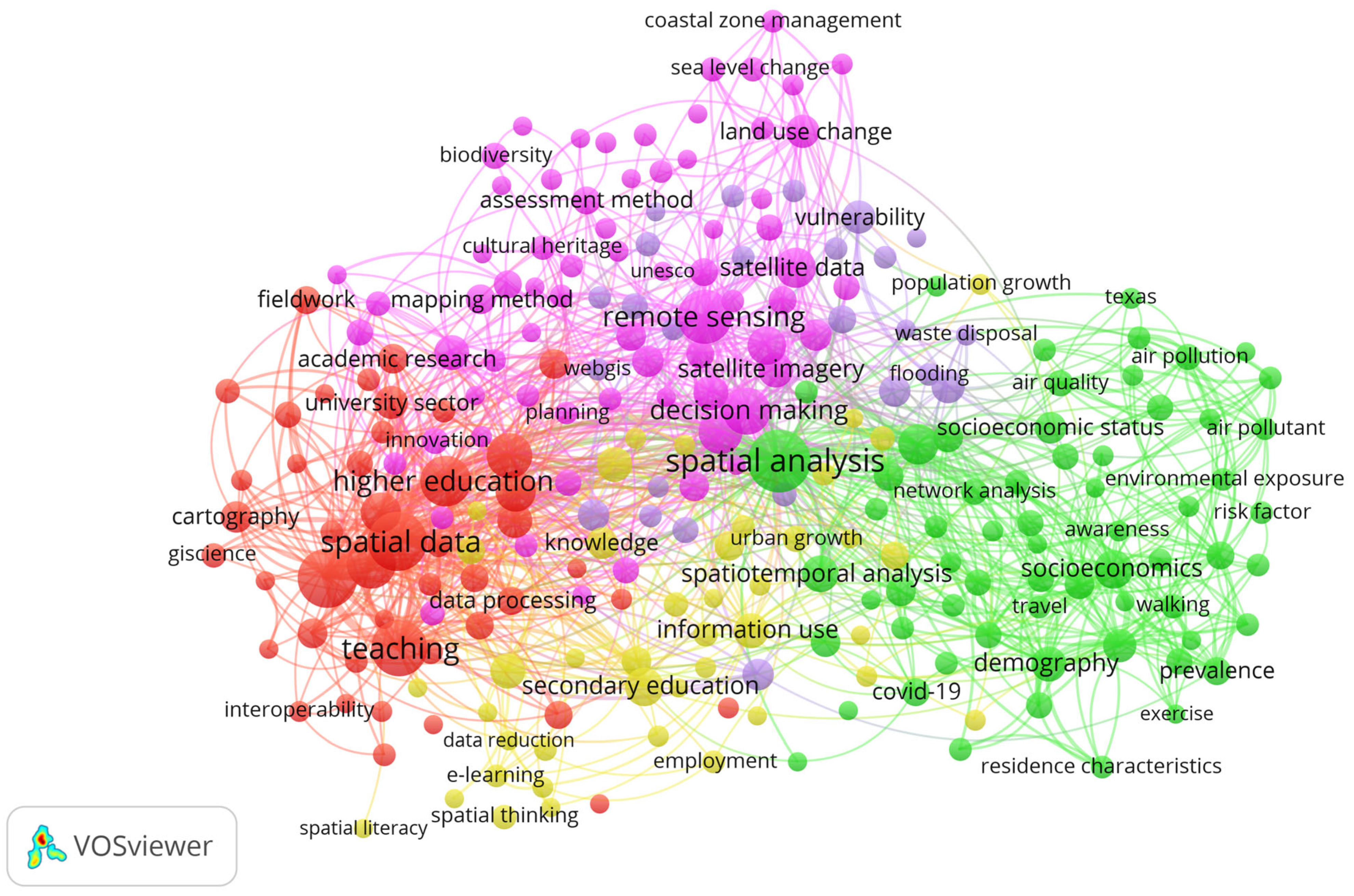
4.2. Keyword Trend Analysis (2000–2024)
- Cluster 1: Education and Geospatial Technologies for Sustainable Development
- Cluster 2: Education and Urban Society
- Cluster 3: Geospatial Education and Emerging Technologies
- Cluster 4: Education and Urban Development with Space Technologies
- Cluster 5: Education and Management of Environmental Risks
4.3. Future Directions of Research
- Collaborative Spatial Data Analysis for Educational Innovation
- Enhancing Spatial Thinking Skills through Intelligent GIS Tools
- Understanding Societal Dynamics to Foster Critical Thinking via GIS Education
- Spatiotemporal GIS-Based Learning Environments for Real-Time Data Interpretation
5. Discussion
6. Conclusions
Author Contributions
Funding
Institutional Review Board Statement
Informed Consent Statement
Data Availability Statement
Conflicts of Interest
References
- Agrawal, S., De Beer, D. J., & Modi, Y. K. (2014). Conversion of a GIS surface data directly to a 3D STL part for terrain modeling. Rapid Prototyping Journal, 20(5), 422–430. [Google Scholar] [CrossRef]
- Aladaǧ, E. (2010). The effects of GIS on students’ academic achievement and motivation in seventh-grade social studies lessons in Turkey. International Research in Geographical and Environmental Education, 19(1), 11–23. [Google Scholar] [CrossRef]
- Anunti, H., Vuopala, E., & Rusanen, J. (2020). A portfolio model for the teaching and learning of gis competencies in an upper secondary school: A case study from a finnish geomedia course. Review of International Geographical Education Online, 10(3), 262–282. [Google Scholar] [CrossRef]
- Augusiak, A., Kutt, F., Musznicki, P., & Nieznański, J. (2024). Engineering education for smart grid systems in the quasi-industrial environment of the LINTE^2 laboratory. Global Journal of Engineering Education, 26(2), 69–74. [Google Scholar]
- Barcus, H. R., & Smith, L. J. (2016). Facilitating native land reacquisition in the rural USA through collaborative research and Geographic Information Systems. Geographical Research, 54(2), 118–128. [Google Scholar] [CrossRef]
- Bearman, N., Jones, N., André, I., Cachinho, H. A., & DeMers, M. (2016). The future role of GIS education in creating critical spatial thinkers. Journal of Geography in Higher Education, 40(3), 394–408. [Google Scholar] [CrossRef]
- Benhart, J. (2000). An approach to leaching applied gis: Implementation for local organizations. Journal of Geography, 99(6), 245–252. [Google Scholar] [CrossRef]
- Berendsen, M. E., Hodza, P., & Hamerlinck, J. D. (2023). Researching student interaction with GIS software while learning spatial concepts: Toward a standard measure of GIS interaction. Journal of Geography, 122(4), 81–92. [Google Scholar] [CrossRef]
- Bédard, Y., Bernier, E., Badard, T., Chrisman, N., Roche, S., Edwards, G., Mostafavi, M. A., Pouliot, J., Gervais, M., Hubert, F., Brodeur, J., & Devillers, R. (2007). Research in geographic information systems, data management and dissemination, and new geospatial technologies|La recherche en systèmes d’information géographique, en gestion et diffusion des données, et en nouvelles technologies géospatiales. Geomatica, 61(3), 299–314. [Google Scholar]
- Brown, S., Küçük, Z. D., Rickard, A., Lonergan, J., Abernethy, R., McNerney, L., McNerney, E., Foley, R., Behan, A., Byrne, A., Faull, J., & Cahalane, C. (2024). The role of teacher agency in using GIS to teach sustainability: An evaluation of a lower secondary school story mapping GIS initiative in Ireland. International Research in Geographical and Environmental Education, 33(1), 56–71. [Google Scholar] [CrossRef]
- Calvo-Sotelo, P. C. (2009). La Educación, un hecho espacial: El “Campus Didáctico” como arquitectura para el Espacio Europeo de Educación Superior. La Cuestión Universitaria, 5, 98–120. [Google Scholar]
- Carrión Montalván, B. K., Pillajo Angos, C. G., Castellanos Fonseca, J. A., & Vega Aguaiza, R. (2024). The influence of artificial intelligence in higher education based on four thematic axes: A bibliometric study. Sapienza: International Journal of Interdisciplinary Studies, 5(2), e24035. [Google Scholar] [CrossRef]
- Chen, X., Chang-Richards, A. Y., Pelosi, A., Jia, Y., Shen, X., Siddiqui, M. K., & Yang, N. (2022). Implementation of technologies in the construction industry: A systematic review. Engineering, Construction and Architectural Management, 29(8), 3181–3209. [Google Scholar] [CrossRef]
- Curl, A., Nelson, J. D., & Anable, J. (2015). Same question, different answer: A comparison of GIS-based journey time accessibility with self-reported measures from the National Travel Survey in England. Computers, Environment and Urban Systems, 49, 86–97. [Google Scholar] [CrossRef]
- Duever, M., & McGinn, E. (2020). Teaching GIS in a digital humanities environment. Journal of Map and Geography Libraries, 16(3), 229–238. [Google Scholar] [CrossRef]
- Duncan, M. J., Winkler, E., Sugiyama, T., Cerin, E., Dutoit, L., Leslie, E., & Owen, N. (2010). Relationships of land use mix with walking for transport: Do land uses and geographical scale matter? Journal of Urban Health, 87(5), 782–795. [Google Scholar] [CrossRef]
- Eddy, B. (2024). A GIS methodology for mapping regional and community vitality for Canada using the CanEcumene 3.0 Geodatabase with census data. One Ecosystem, 9, 1–22. [Google Scholar] [CrossRef]
- Ferrandino, J. (2015). Using GIS to apply learning across the undergraduate criminal justice curriculum. Journal of Criminal Justice Education, 26(1), 74–93. [Google Scholar] [CrossRef]
- G. Almatar, M., Alazmi, H. S., Li, L., & Fox, E. A. (2020). Applying GIS and text mining methods to Twitter data to explore the spatiotemporal patterns of topics of interest in Kuwait. ISPRS International Journal of Geo-Information, 9(12), 702. [Google Scholar] [CrossRef]
- Giski, Z. E., & Ebrahimzadeh, A. (2019). Unifying entropies of quantum logic based on Rényi entropies. Reports on Mathematical Physics, 83(3), 305–327. [Google Scholar] [CrossRef]
- Golumbeanu, M., & Avdimiotis, S. (2009). Destination management, coastal spatial analysis and GIS. The case of Chalkidiki Greece. Journal of Environmental Protection and Ecology, 10(4), 1100–1112. [Google Scholar]
- González-Zamar, M. D., & Abad-Segura, E. (2024). Analysing the teaching-learning process in the university virtual classroom at the beginning of the COVID-19 pandemic. Culture and Education, 36(1), 190–217. [Google Scholar] [CrossRef]
- González-Zamar, M. D., Abad-Segura, E., & Belmonte-Ureña, L. J. (2020a). Meaningful learning in the development of digital skills. Trend analysis|Aprendizaje significativo en el desarrollo de competencias digitales. Análisis de tendencias. International Journal of Educational Research and Innovation, 2020(14), 91–110. [Google Scholar] [CrossRef]
- González-Zamar, M.-D., Abad-Segura, E., Luque de la Rosa, A., & López-Meneses, E. (2020b). Digital education and artistic-visual learning in flexible university environments: Research analysis. Education Sciences, 10(11), 294. [Google Scholar] [CrossRef]
- Haedrich, C., Petras, V., Petrasova, A., Blumentrath, S., & Mitasova, H. (2023). Integrating GRASS GIS and Jupyter notebooks to facilitate advanced geospatial modeling education. Transactions in GIS, 27(3), 686–702. [Google Scholar] [CrossRef]
- Hallak, J., & Polat, E. G. (2021). A MCDM based on goal programming and GIS-based risk assessment for the evaluation of educational locations in conflict areas. Foundations of Computing and Decision Sciences, 46(4), 361–391. [Google Scholar] [CrossRef]
- Hawthorne, T. L., & Kwan, M.-P. (2012). Using GIS and perceived distance to understand the unequal geographies of healthcare in lower-income urban neighbourhoods. Geographical Journal, 178(1), 18–30. [Google Scholar] [CrossRef]
- Hogrebe, M. C., Kyei-Blankson, L., & Zou, L. (2008). Examining regional science attainment and school-teacher resources using GIS. Education and Urban Society, 40(5), 570–589. [Google Scholar] [CrossRef]
- Jakab, I., Ševčík, M., & Grežo, H. (2017). Model of higher GIS education. Electronic Journal of E-Learning, 15(3), 220–234. [Google Scholar]
- Jażdżewska, I. A., Lechowski, Ł., & Babuca, D. (2022). GIS-based approach for the analysis of geographical education paths. ISPRS International Journal of Geo-Information, 11(1), 41. [Google Scholar] [CrossRef]
- Jesus, R. H. G. d., Barros, M. V., Salvador, R., Souza, J. T. d., Piekarski, C. M., & Francisco, A. C. d. (2021). Forming clusters based on strategic partnerships and circular economy for biogas production: A GIS analysis for optimal location. Biomass and Bioenergy, 150, 106097. [Google Scholar] [CrossRef]
- Jiménez-Espada, M., Cuartero, A., & Breton, M. L. (2022). Sustainability assessment through urban accessibility indicators and GIS in a middle-sized world heritage city: The case of Cáceres, Spain. Buildings, 12(6), 813. [Google Scholar] [CrossRef]
- Kamruzzaman, M. (2014). Development of an integrated GIS and land use planning course: Impacts of hybrid instructional methods. Journal of Geography in Higher Education, 38(3), 323–347. [Google Scholar] [CrossRef]
- Karl, J. W., Herrick, J. E., & Browning, D. M. (2012). A strategy for rangeland management based on best available knowledge and information. Rangeland Ecology and Management, 65(6), 638–646. [Google Scholar] [CrossRef]
- Kerski, J. J. (2003). The implementation and effectiveness of geographic information systems technology and methods in secondary education. Journal of Geography, 102(3), 128–137. [Google Scholar] [CrossRef]
- Kerski, J. J., Demirci, A., & Milson, A. J. (2013). The Global Landscape of GIS in Secondary Education. Journal of Geography, 112(6), 232–247. [Google Scholar] [CrossRef]
- Kim, M., Kim, K., & Lee, S.-I. (2013). Pedagogical potential of a web-based GIS application for migration data: A preliminary investigation in the context of South Korea. Journal of Geography, 112(3), 97–107. [Google Scholar] [CrossRef]
- Klooster, D., Strout, N., & Smith, D. (2022). GIS in the jungle: Experiential Environmental Education (EEE) in Panama. Journal of Environmental Studies and Sciences, 12(1), 164–176. [Google Scholar] [CrossRef]
- Kurniawan, E., Syifauddin, M., Sholeh, M., Sriyanto, & Sari, S. N. (2024). Environmental problem-solving learning model with geographic information system-based learning media. International Journal of Environmental Impacts, 7(3), 381–394. [Google Scholar] [CrossRef]
- Lei, Z., Zhou, H., Hu, W., & Liu, G.-P. (2023). Flipping laboratories toward future experimentation systems: The blended use of hands-on, pocket, and online laboratories. IEEE Industrial Electronics Magazine, 17(2), 48–60. [Google Scholar] [CrossRef]
- Liu, Z. Q. (2003). Fuzzy cognitive maps in GIS data analysis. Soft Computing, 7(6), 394–401. [Google Scholar] [CrossRef]
- Liu, Z. Q., & Satur, R. (1999). Contextual fuzzy cognitive map for decision support in geographic information systems. IEEE Transactions on Fuzzy Systems, 7(5), 495–507. [Google Scholar] [CrossRef]
- López-Meneses, E., López-Catalán, L., Pelícano-Piris, N., & Mellado-Moreno, P. C. (2025). Artificial intelligence in educational data mining and human-in-the-loop machine learning and machine teaching: Analysis of scientific knowledge. Applied Sciences, 15(2), 772. [Google Scholar] [CrossRef]
- Lulu, J., Xiuhua, L., & Wei, F. (2022). Analysis of animation peripheral design ability based on artificial intelligence. Scientific Programming, 2022, 3245441. [Google Scholar] [CrossRef]
- Magzoub, M. E., Taha, M. H., Waller, S., Al Eissa, A. M., Hamdy, H., Norcini, J., Al Marzooqi, S., Shaban, S., Elhassan Abdalla, M., & Schmidt, H. (2024). Going beyond competencies: Building blocks for a patient- and population-centered medical curriculum. Medical Teacher, 46(12), 1568–1574. [Google Scholar] [CrossRef]
- Mamun, M. A., Roy, N., Gozal, D., Almerab, M. M., Hossain, M. S., & Al Mamun, F. (2024). Prevalence and associated factors of cigarette smoking and substance use among university entrance test-taking students: A GIS-based study. PLoS ONE, 19(8), e0308697. [Google Scholar] [CrossRef] [PubMed]
- March, G., & Scarletto, E. (2017). The evolution of GIS services within North American academic libraries: Documenting change through the decades (1995–2016). Journal of Map and Geography Libraries, 13(2), 222–245. [Google Scholar] [CrossRef]
- Merry, K., Bettinger, P., Grebner, D., Boston, K., & Siry, J. (2016). Assessment of geographic information system (GIS) skills employed by graduates from three forestry programs in the United States. Forests, 7(12), 304. [Google Scholar] [CrossRef]
- Milson, A. J., & Earle, B. D. (2007). Internet-based GIS in an inductive learning environment: A case study of ninth-grade geography students. Journal of Geography, 106(6), 227–237. [Google Scholar] [CrossRef]
- Mitchell, J. T., Roy, G., Fritch, S., & Wood, B. (2018). GIS professional development for teachers: Lessons learned from high-needs schools. Cartography and Geographic Information Science, 45(4), 292–304. [Google Scholar] [CrossRef]
- Moher, D., Altman, D. G., Liberati, A., & Tetzlaff, J. (2011). PRISMA statement. Epidemiology, 22(1), 128. [Google Scholar] [CrossRef] [PubMed]
- Morgan, J. D., Eddy, B., & Coffey, J. W. (2022). Activating student engagement with concept mapping: A Web GIS case study. Journal of Geography in Higher Education, 46(1), 128–144. [Google Scholar] [CrossRef]
- Mulaku, G. C., & Nyadimo, E. (2011). GIS in education planning: The Kenyan school mapping project. Survey Review, 43(323), 567–578. [Google Scholar] [CrossRef]
- Park, Y. M. (2022). A GPS-enabled portable air pollution sensor and web-mapping technologies for field-based learning in health geography. Journal of Geography in Higher Education, 46(2), 241–261. [Google Scholar] [CrossRef]
- Perugini, S., & Bodzin, A. M. (2020). Using web-based GIS to assess students’ geospatial knowledge of hurricanes and spatial habits of mind. Journal of Geography, 119(2), 63–73. [Google Scholar] [CrossRef]
- Peter, B. G., Messina, J. P., Lin, Z., & Snapp, S. S. (2020). Crop climate suitability mapping on the cloud: A geovisualization application for sustainable agriculture. Scientific Reports, 10(1), 15487. [Google Scholar] [CrossRef]
- Ramezan, C. A., Maxwell, A. E., & Meadows, J. T. (2024). An analysis of qualifications and requirements for geographic information systems (GIS) positions in the United States. Transactions in GIS, 28(5), 1090–1110. [Google Scholar] [CrossRef]
- Rutkofske, J. E., Pavlis, T. L., & Ramirez, S. (2022). Applications of modern digital mapping systems to Assist inclusion of persons with disabilities in geoscience education and research. Journal of Structural Geology, 161, 104655. [Google Scholar] [CrossRef]
- Sanabria-Z, J., & Olivo, P. G. (2024). AI platform model on 4IR megatrend challenges: Complex thinking by active and transformational learning. Interactive Technology and Smart Education, 21(4), 571–587. [Google Scholar] [CrossRef]
- Shi, W. (2003). State-of-the-art and future of geographic information systems in Hong Kong. Geographic Information Sciences, 9(1–2), 1–13. [Google Scholar] [CrossRef]
- Smith, K. I., & Shirowzhan, S. (2022). A GIS-based spatiotemporal analysis of the relationship between the outbreak of COVID-19, delta variant and construction in Sydney and Melbourne. ISPRS International Journal of Geo-Information, 11(12), 617. [Google Scholar] [CrossRef]
- Sofias, T. A., & Pierrakeas, C. J. (2023). Student engagement and educational benefits of web GIS-based projects. International Journal of Web-Based Learning and Teaching Technologies, 18(1), 1–16. [Google Scholar] [CrossRef]
- Summerby-Murray, R. (2001). Analysing heritage landscape with historical GIS: Contributions form problem-based inquiry and constructivist pedalogy. Journal of Geography in Higher Education, 25(1), 37–52. [Google Scholar] [CrossRef]
- Tedyyana, A., Ahmad, A. A., Idrus, M. R., Shabli, A. H. M., Seman, M. A. A., Ghazali, O., Jaroji, & Razak, A. H. A. (2024). Enhance telecommunication security through the integration of support vector machines. International Journal of Advanced Computer Science and Applications, 15(3), 633–640. [Google Scholar] [CrossRef]
- Tepavčević, B., Sijakov, M., & Signanin, P. (2012). Gis technologies in urban planning and education. Pollack Periodica, 7(Suppl. S1), 185–191. [Google Scholar] [CrossRef]
- Testi, E., & Giorgetti, A. (2021). Blind wireless network topology inference. IEEE Transactions on Communications, 69(2), 1109–1120. [Google Scholar] [CrossRef]
- Thatcher, J. E., & Imaoka, L. B. (2018). The poverty of GIS theory: Continuing the debates around the political economy of GISystems. Canadian Geographer, 62(1), 27–34. [Google Scholar] [CrossRef]
- Theo, L. (2011). Simplifying central place theory using GIS and GPS. Journal of Geography, 110(1), 16–26. [Google Scholar] [CrossRef]
- Tinker, R. F. (1992). Mapware: Educational applications of geographic information systems. Journal of Science Education and Technology, 1(1), 35–48. [Google Scholar] [CrossRef]
- van Eck, N. J., & Waltman, L. (2007). VOS: A new method for visualizing similarities between objects. In Advances in data analysis (pp. 299–306). Studies in classification, data analysis, and knowledge organization. Springer. [Google Scholar] [CrossRef]
- van Eck, N. J., & Waltman, L. (2010). Software survey: VOSviewer, a computer program for bibliometric mapping. Scientometrics, 84(2), 523–538. [Google Scholar] [CrossRef]
- Van Eck, N. J., Waltman, L., Noyons, E. C. M., & Buter, R. K. (2010). Automatic term identification for bibliometric mapping. Scientometrics, 82(3), 581–596. [Google Scholar] [CrossRef]
- van Leusen, P., Ottenbreit-Lefwich, A. T., & Brush, T. (2016). Interpersonal consulting skills for instructional technology consultants: A multiple case study. TechTrends, 60(3), 253–259. [Google Scholar] [CrossRef]
- Walther, S. C., Dengenis, E. M., & Gurung, K. (2019). Using GIS and remote sensing to map grassroots sustainable development for a small NGO in Nepal. International Journal of Geospatial and Environmental Research, 6(1), 1–18. [Google Scholar]
- Waltman, L., van Eck, N. J., & Noyons, E. C. M. (2010). A unified approach to mapping and clustering of bibliometric networks. Journal of Informetrics, 4(4), 629–635. [Google Scholar] [CrossRef]
- Wang, D., Liu, Y., Jing, X., Liu, Q., & Lu, Q. (2025). Catalyst for future education: An empirical study on the impact of artificial intelligence generated content on college students’ innovation ability and autonomous learning. Education and Information Technologies, 30, 9949–9968. [Google Scholar] [CrossRef]
- Wilhelmi, O. V., & Betancourt, T. L. (2005). Evolution of NCAR’s GIS initiative. Bulletin of the American Meteorological Society, 86(2), 176–178. [Google Scholar] [CrossRef]
- Xia, J., Zhang, Y. Y., Xiong, L. H., He, S., Wang, L. F., & Yu, Z. B. (2017). Opportunities and challenges of the Sponge City construction related to urban water issues in China. Science China Earth Sciences, 60(4), 652–658. [Google Scholar] [CrossRef]
- Zhang, S. (2020). Expanding library GIS instruction to web mapping in the age of neogeography. Journal of Map and Geography Libraries, 16(3), 264–282. [Google Scholar] [CrossRef]


| R | Keyword | N | Cluster | Links | TLS | R | Keyword | N | Cluster | Links | TLS |
|---|---|---|---|---|---|---|---|---|---|---|---|
| 1 | spatial analysis | 2 | 178 | 399 | 94 | 16 | spatiotemporal analysis | 2 | 69 | 97 | 24 |
| 2 | spatial data | 3 | 128 | 334 | 82 | 17 | information management | 1 | 76 | 110 | 23 |
| 3 | geography education | 3 | 79 | 240 | 78 | 18 | demography | 2 | 67 | 123 | 22 |
| 4 | teaching | 3 | 90 | 239 | 70 | 19 | engineering education | 4 | 62 | 95 | 22 |
| 5 | remote sensing | 1 | 133 | 262 | 63 | 20 | satellite imagery | 1 | 73 | 105 | 22 |
| 6 | higher education | 3 | 80 | 176 | 53 | 21 | sustainable development | 1 | 62 | 91 | 22 |
| 7 | learning | 3 | 70 | 190 | 49 | 22 | data acquisition | 3 | 70 | 111 | 21 |
| 8 | mapping | 3 | 98 | 166 | 42 | 23 | environmental education | 4 | 63 | 86 | 21 |
| 9 | data set | 1 | 113 | 180 | 37 | 24 | risk assessment | 5 | 70 | 101 | 20 |
| 10 | internet | 3 | 72 | 125 | 30 | 25 | vulnerability | 5 | 47 | 75 | 20 |
| 11 | satellite data | 1 | 70 | 121 | 30 | 26 | knowledge | 4 | 57 | 74 | 18 |
| 12 | urban area | 2 | 101 | 168 | 30 | 27 | cartography | 3 | 36 | 61 | 17 |
| 13 | urban planning | 1 | 80 | 115 | 28 | 28 | spatial distribution | 5 | 32 | 41 | 17 |
| 14 | secondary education | 4 | 54 | 93 | 26 | 29 | geography | 5 | 43 | 63 | 16 |
| 15 | socioeconomics | 2 | 90 | 197 | 26 | 30 | computer simulation | 1 | 64 | 85 | 15 |
| Rank | Future Line of Research | Relevance Score |
|---|---|---|
| 1 | Collaborative Spatial Data Analysis for Educational Innovation | 14.962 |
| 2 | Enhancing Spatial Thinking Skills through Intelligent GIS Tools | 14.795 |
| 3 | Understanding Societal Dynamics to Foster Critical Thinking via GIS Education | 13.862 |
| 4 | Spatiotemporal GIS-Based Learning Environments for Real-Time Data Interpretation | 13.547 |
Disclaimer/Publisher’s Note: The statements, opinions and data contained in all publications are solely those of the individual author(s) and contributor(s) and not of MDPI and/or the editor(s). MDPI and/or the editor(s) disclaim responsibility for any injury to people or property resulting from any ideas, methods, instructions or products referred to in the content. |
© 2025 by the authors. Licensee MDPI, Basel, Switzerland. This article is an open access article distributed under the terms and conditions of the Creative Commons Attribution (CC BY) license (https://creativecommons.org/licenses/by/4.0/).
Share and Cite
López-Meneses, E.; Palomero-Ilardia, I.-M.; Pelícano-Piris, N.; Morales-Cevallos, M.-B. Harnessing Intelligent GISs for Educational Innovation: A Bibliometric Analysis of Real-Time Data Models. Educ. Sci. 2025, 15, 976. https://doi.org/10.3390/educsci15080976
López-Meneses E, Palomero-Ilardia I-M, Pelícano-Piris N, Morales-Cevallos M-B. Harnessing Intelligent GISs for Educational Innovation: A Bibliometric Analysis of Real-Time Data Models. Education Sciences. 2025; 15(8):976. https://doi.org/10.3390/educsci15080976
Chicago/Turabian StyleLópez-Meneses, Eloy, Irene-Magdalena Palomero-Ilardia, Noelia Pelícano-Piris, and María-Belén Morales-Cevallos. 2025. "Harnessing Intelligent GISs for Educational Innovation: A Bibliometric Analysis of Real-Time Data Models" Education Sciences 15, no. 8: 976. https://doi.org/10.3390/educsci15080976
APA StyleLópez-Meneses, E., Palomero-Ilardia, I.-M., Pelícano-Piris, N., & Morales-Cevallos, M.-B. (2025). Harnessing Intelligent GISs for Educational Innovation: A Bibliometric Analysis of Real-Time Data Models. Education Sciences, 15(8), 976. https://doi.org/10.3390/educsci15080976