
The Field Skills’ Development through Teaching Environmental Interactions in High School: Draa-Tafilalet Region, Morocco


Abstract
1. Introduction
- apprehend evidence of the practical skills developed from fieldwork teaching;
- test the students’ degrees of acquisition of knowledge skills related to how it allows students to understand the sediments’ dynamics in their local and regional contexts;
- test the students’ degrees of acquisition of technological skills and communication in the fieldwork practice;
- discuss the virtues and lessons students learned as useful skills and tools for the future.
2. Theoretical Background, Context, and Methodology
2.1. Theoretical Background
2.2. Methodology
- The general framework which integrates the fieldwork as a part of a more general research model. It includes its three stages before (the diagnostic stage), during (the realization), and after the fieldwork (the evaluation of achievements).
- The procedural phase of the fieldwork.
- The second level consists of the procedural dimensions of the fieldwork. They were precisely described to inform on the fieldwork itself and how its different actions may contribute to achieve the study’s goals.
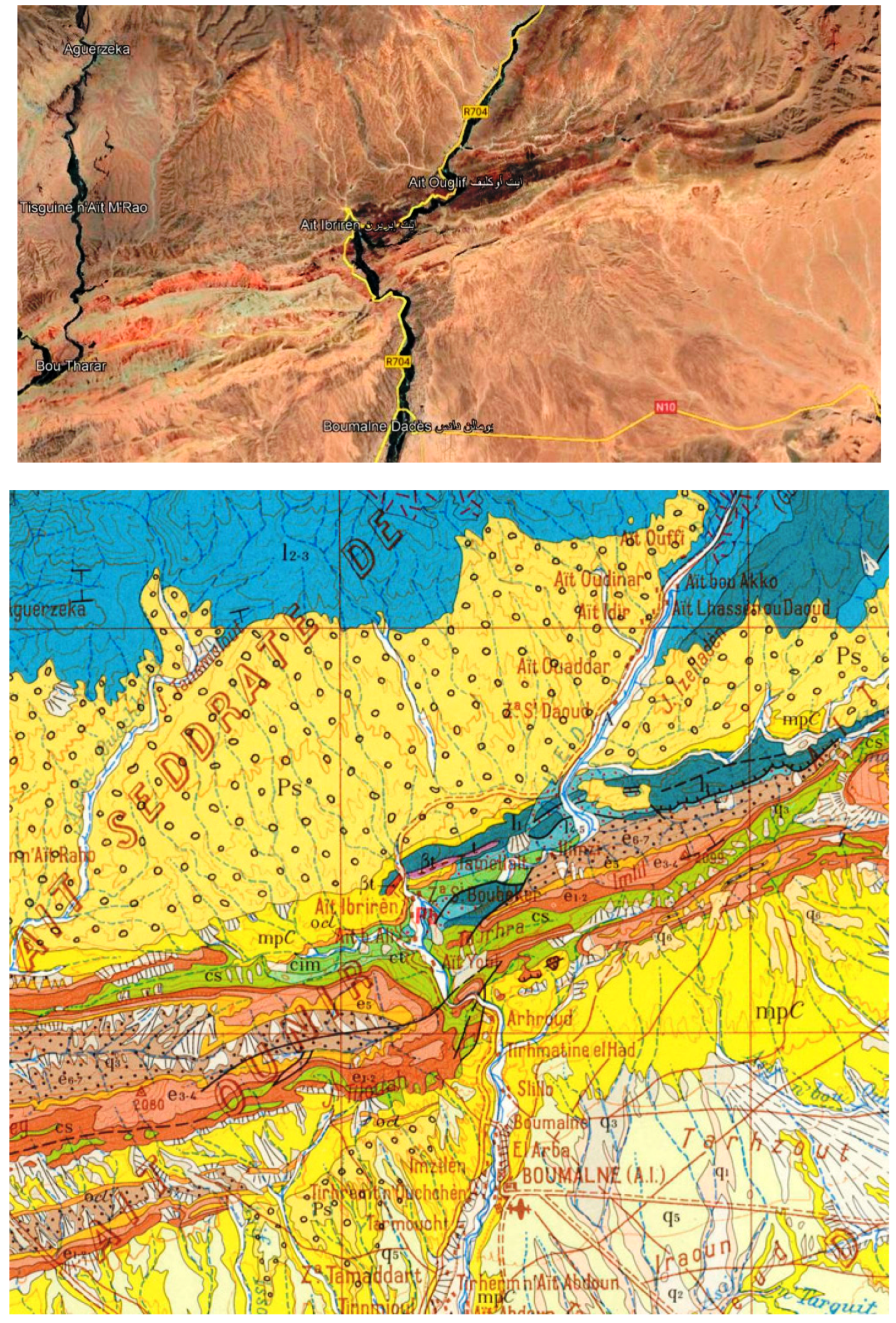
2.2.1. The Study Area, Participants, and Research Design
2.2.2. Variables and Data Analysis
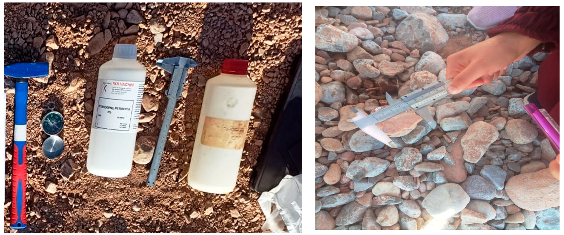
2.2.3. Tools to Enhance Skills Development
3. Results
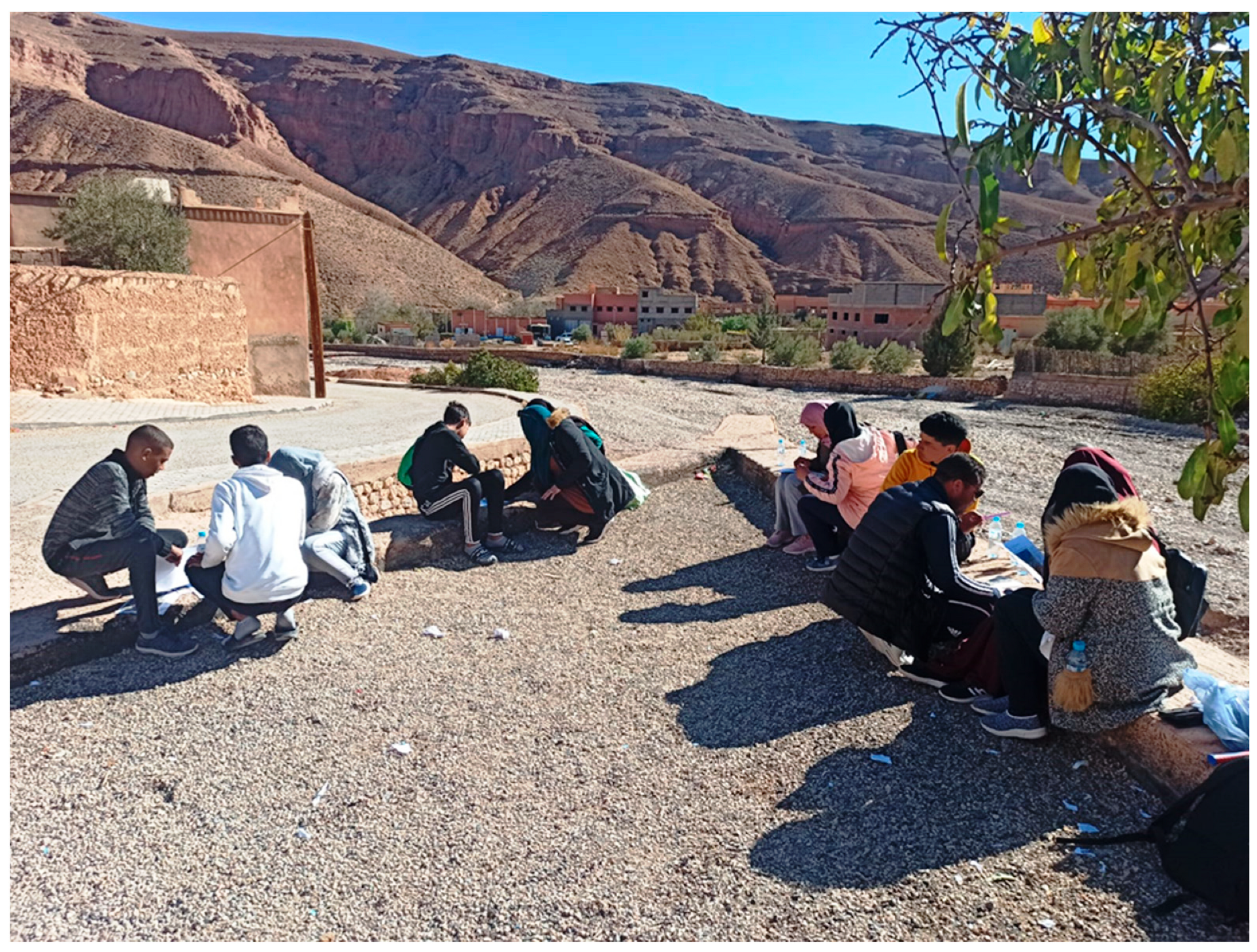
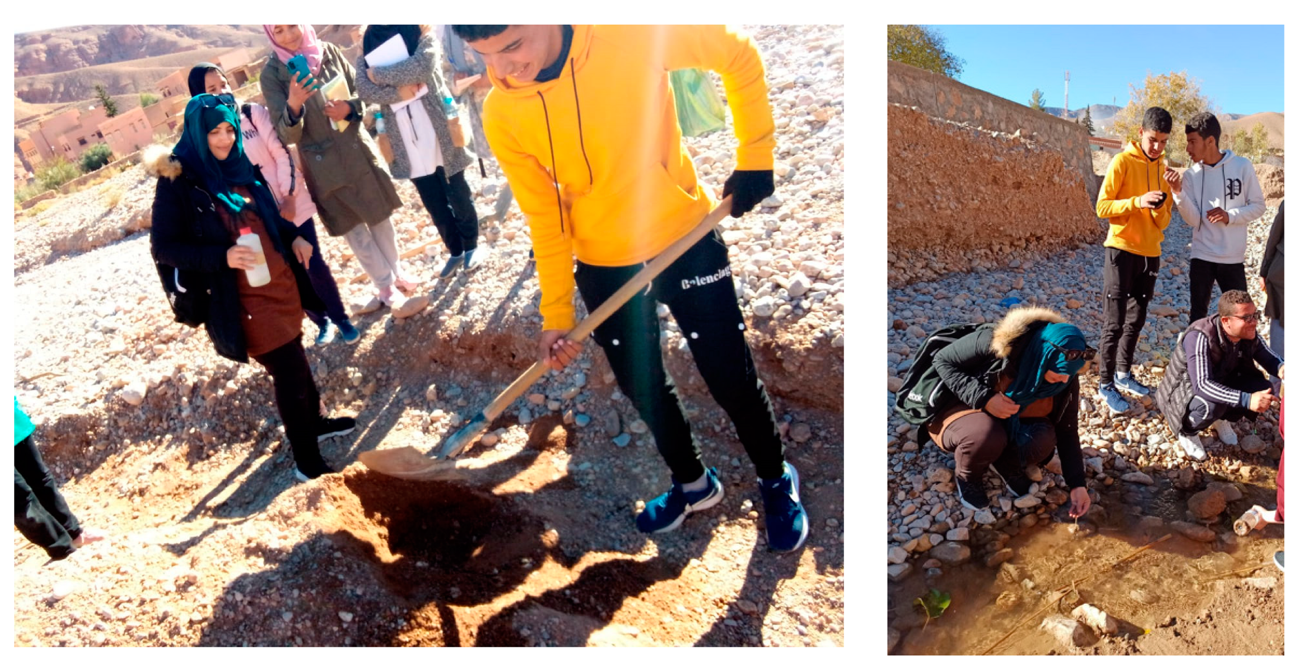
3.1. Fieldwork, a Space of Dialog, and Skills Development
3.2. Fieldwork Facilitates Contextualization in Teaching
3.3. Evidence of the Interdependence and Interactivity from Fieldwork
3.4. Applied Techniques and Development of Technical Skills
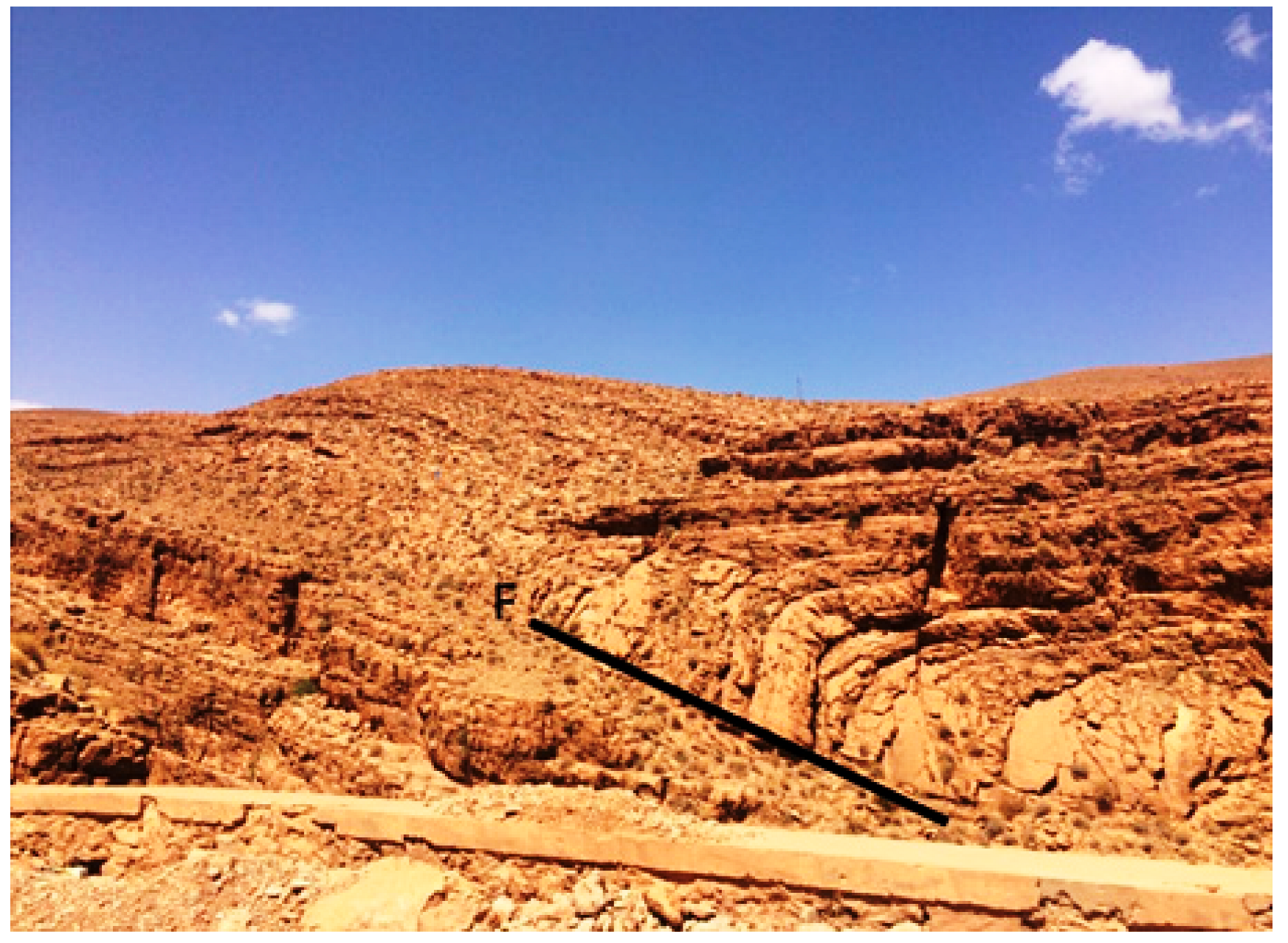
3.5. Apprehension of Latent and Evident Factors of Landscape Dynamics: The Karstic and Tectonic Effects
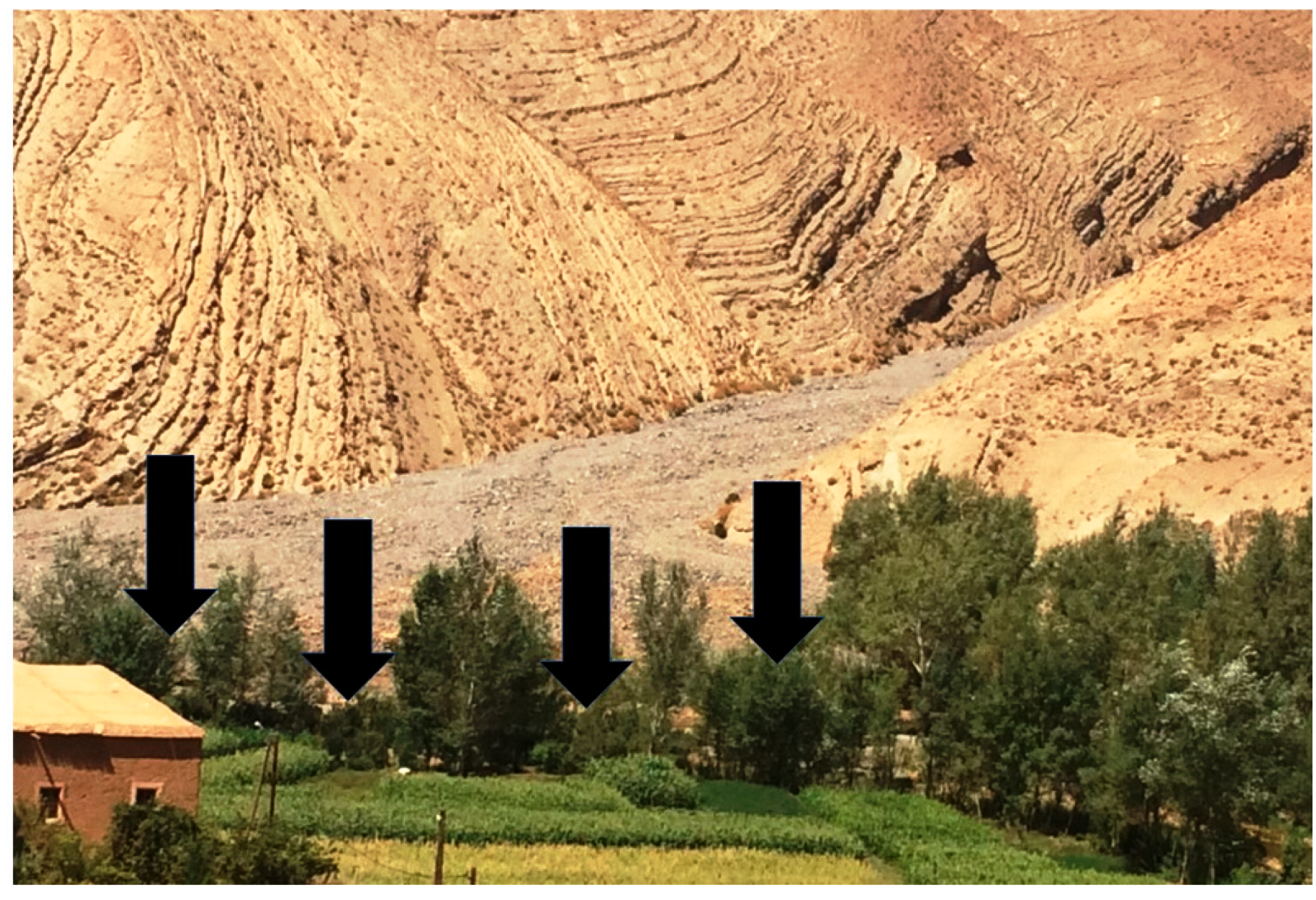
3.6. Environmental Risk from Sediments and Arable Soils Damaging
4. Discussion
4.1. Specialized Knowledge Skills Acquirement
4.2. Technical Skills Development
4.3. Personal Skills Development and Social Integration
4.4. Communication Skills
5. Conclusions
Author Contributions
Funding
Institutional Review Board Statement
Informed Consent Statement
Data Availability Statement
Conflicts of Interest
Appendix A. (Pre-Test)
- Observation and knowledge (scientific and methodological skills).
- Organization: classification and assembly (methodological competence).
- Construction of concepts through abstraction and generalization (methodological competence).
- Acquisition of a geological and environmental culture (cultural competence).
- Oral and written expression (communication skills).
- Good command of the use of laboratory and field tools (technological competence).
- Analytical and interpretative skills.
- weak
- medium
- well
- very well.

- - All the sieves are shaken for 15 min, then the fractions retained in the different sieves are weighed

- - We weigh 100 g of the sand sample and put it on the upper sieve of a series of superimposed sieves, the mesh of which will decrease from top to bottom as follows: 2, 1, 0.5, 0.25, 0.125, 0.63 mm

- - The sand sample is left to air dry.

- - The material retained in each sieve is weighed.

- - The sand sample is treated with HCL acid and then with hydrogen peroxide.

- - The sand sample is washed to remove clays and silts

- To remove limescale.
- To remove organic matter.
- To remove clays.
- To remove clays.
- To remove organic matter.
- To remove limescale.


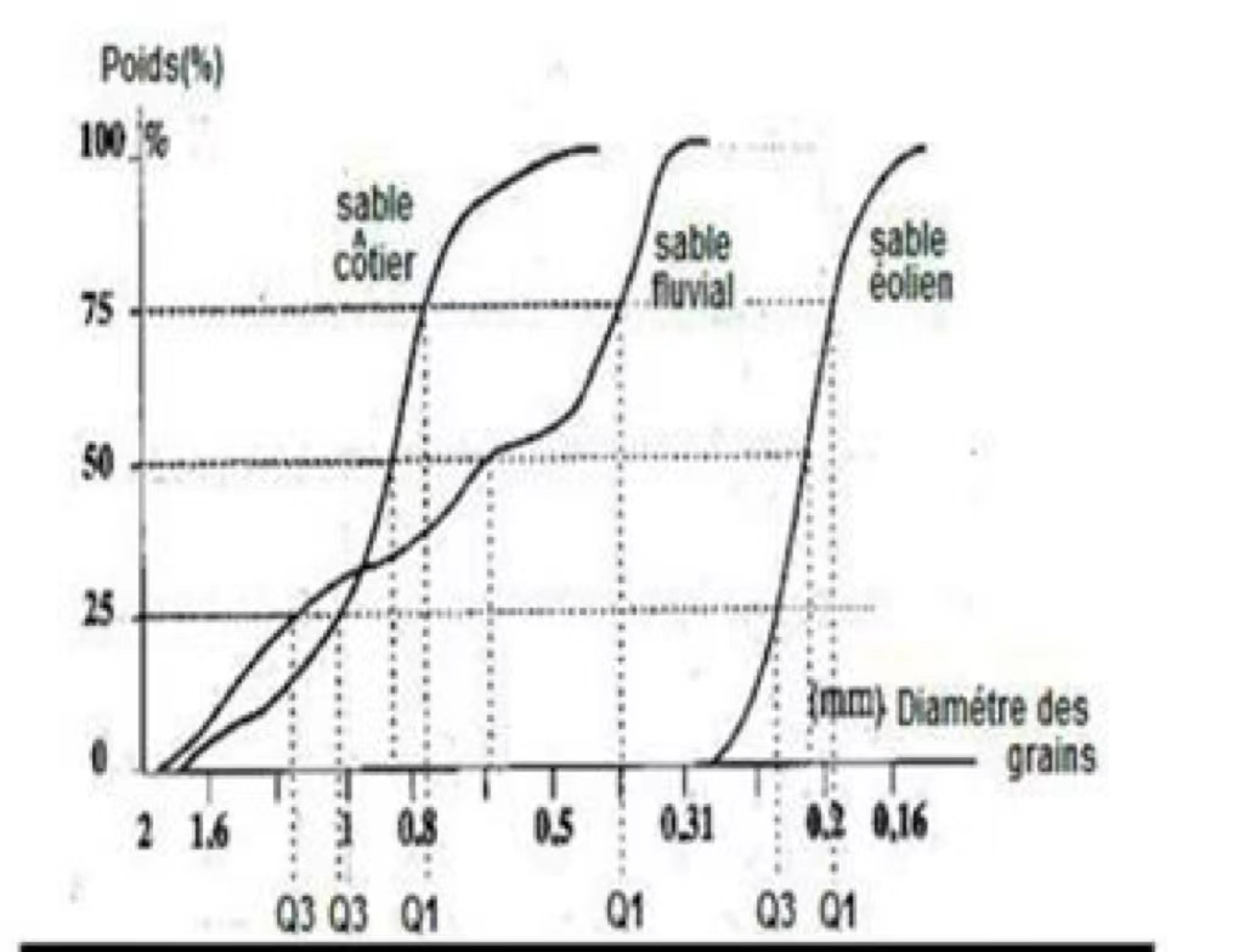
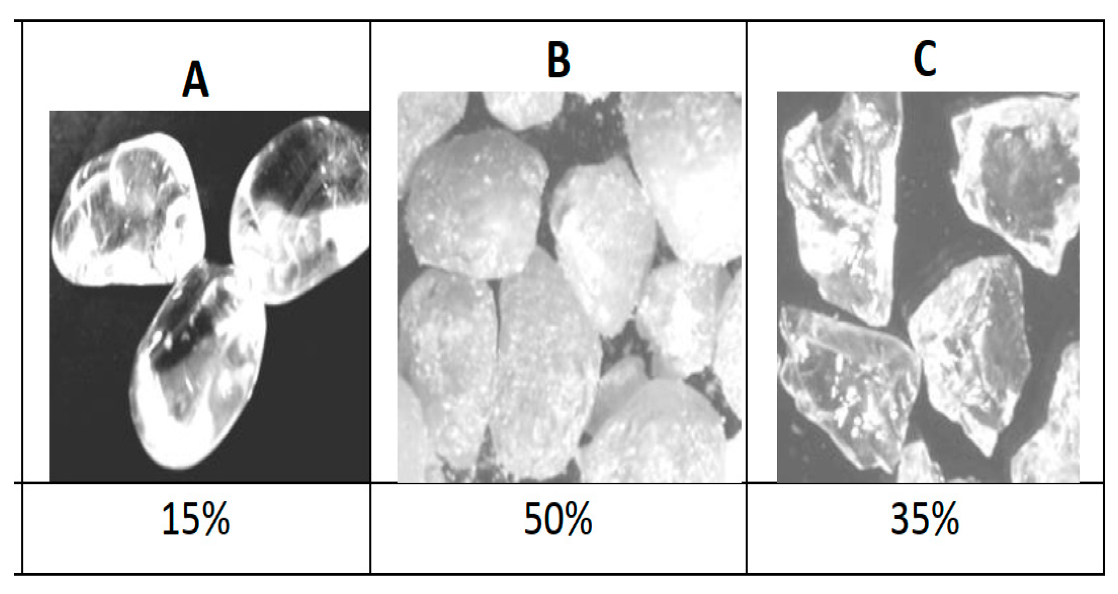
- beach sand
- fluvial sand
- Eolien sand

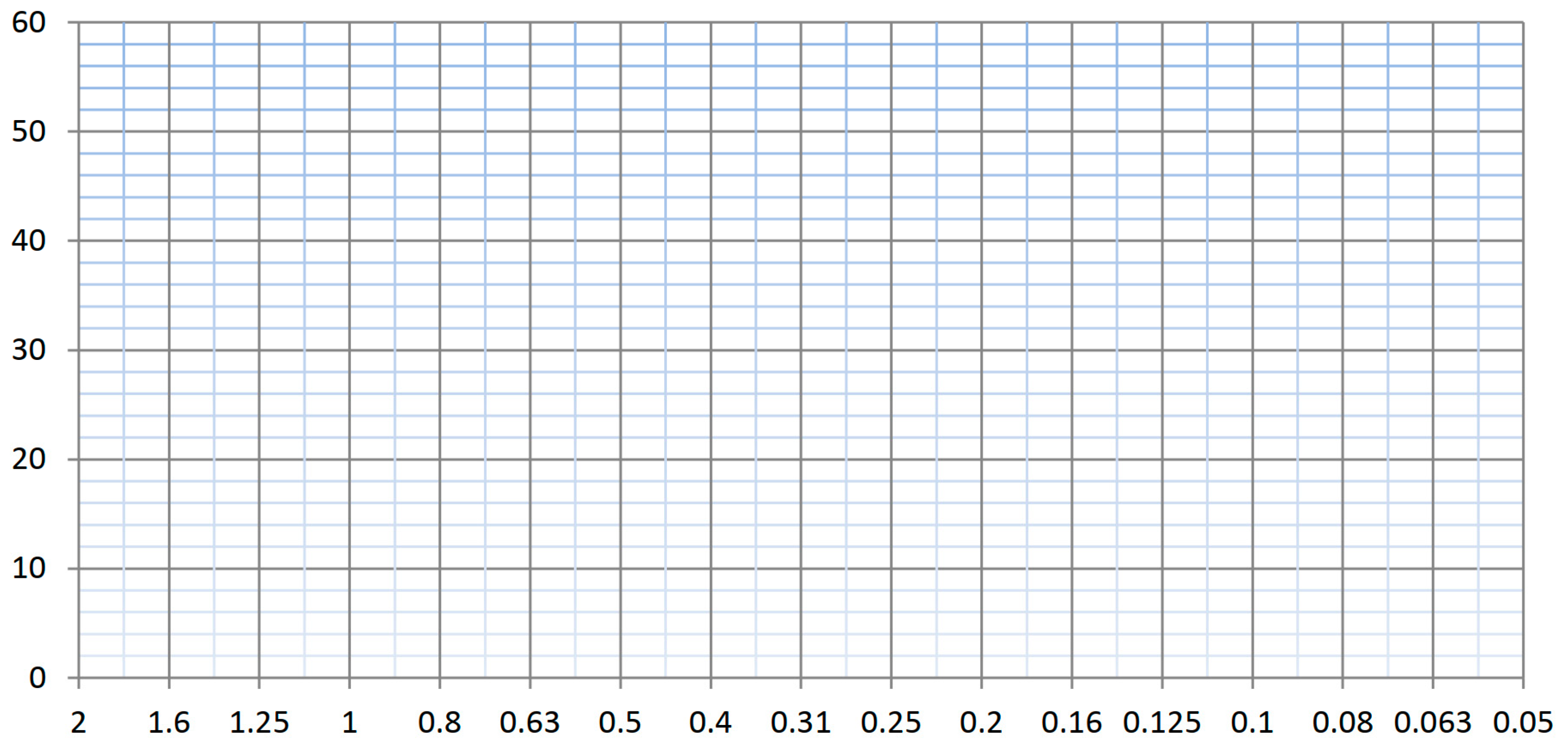
| Accumulated Sand B (%) | Diameter (mm) |
|---|---|
| 1 | 2 |
| 10 | 1.6 |
| 30 | 1.25 |
| 48 | 1 |
| 65 | 0.8 |
| 88 | 0.63 |
| 98 | 0.5 |
| 100 | 0.4 |


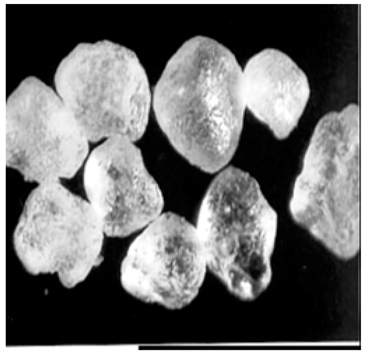
- Glossy Dull (EL)?
- Not worn (NU)?
- Matte round (RM)?
- The mouths, the coastal beaches
- Coastal or desert dunes
- Glacial deposits of origin proximal to the bedrock
- Glacial deposits of origin proximal to the bedrock
- Coastal or desert dunes
- The mouths, the coastal beaches
- Coastal or desert dunes
- The mouths, the coastal beaches
- Glacial deposits of origin proximal to the bedrock
| Unused Grains | Shiny Blunt Grains | Matt Round Grains | |
|---|---|---|---|
| Sample 1 | 22 | 8 | 70 |
| Sample 2 | 10 | 70 | 20 |
- short transport by water. The grains of this sand have undergone a short transport by water.
- deposit at the mouths or in a beach.
- long transport by water. The grains of this sand have undergone a long transport by water
- Short transport by water. The grains of this sand have undergone a short transport by water. Deposit at the mouths or in a beach
- Long transport by the wind, deposit at the level of coastal or Saharan dunes.
- Long transport by water. The grains of this sand have undergone a long transport by water. Deposit at the mouths or in a beach
Appendix B. Evaluation Questionnaire of the Post Test
- Observation and knowledge (scientific and methodological skills).
- Organization: classification and data assembly (methodological competence).
- Concepts development through abstraction and generalization (methodological competence).
- Acquisition of a geological and environmental culture (cultural competence).
- Oral and written expression (communication skills).
- Use of laboratory and field tools (technological competences).
- Analytical and interpretive skills.

- Weak

- Medium

- Satisfied

- Perfect
| Classification of Sand | S0 √Q3/Q1 |
|---|---|
| S0 ≤ 0.5 | Ultra classified |
| 0.5 ≤ S0 < 1.23 | Very well classified |
| 1.23 ≤ S0 < 1.41 | Well classified |
| 1.41 ≤ S0 < 1.74 | Medium classement |
| 1.74 ≤ S0 < 2 | badly classified |
| S0 ≥ 2 | Non classified |

| Sample 1 | Sample 2 | |||
|---|---|---|---|---|
| Diameter in mm | Weight in % | Cumulative Weight in % | Weight in % | Cumulative Weight in % |
| 2 | 0 | 0 | 0 | 0 |
| 1.6 | 4 | 4 | 0 | 0 |
| 1.25 | 8.3 | 12.3 | 0 | 0 |
| 1 | 11.9 | 24.2 | 0 | 0 |
| 0.8 | 5 | … | 0 | 0 |
| 0.63 | 4.5 | … | 0 | 0 |
| 0.5 | 8 | … | 0 | 0 |
| 0.4 | 9.3 | … | 0.1 | 0.1 |
| 0.31 | 11.5 | … | 5.1 | 5.2 |
| 0.25 | 14 | … | 26.1 | … |
| 0.2 | 10 | … | 57.5 | … |
| 0.16 | 7 | … | 9.1 | … |
| 0.125 | 4,5 | … | 1.6 | … |
| 0.1 | 1.5 | … | 0.5 | … |
| 0.08 | 0.5 | … | 0 | … |
| 0.63 | 0 | … | 0 | … |

- Short transport by water. The grains of this sand have undergone a short transport by water. Deposit at the mouths or in a beach.
- Long transport by the wind, deposit at the level of coastal or Saharan dunes.
- Long transport by water. The grains of this sand have undergone a long transport by water. Deposit at the mouths or in a beach.
- -
- a. long transport by the wind,
- -
- b. long transport by water,
- -
- c. short water transport.
References
- Cook, S. Coaching for High Performance, How to Develop Exceptional Results through Coaching; Cambridgeshire Business: Cambridge, UK, 2009; 127p. [Google Scholar]
- Riggio, R.E.; Tan Sherylle, J. (Eds.) Leader Interpersonal And influence Skills: The Soft Skills of Leadership; Routledge: London, UK, 2014; 376p. [Google Scholar]
- Babu, A.; Ramesh Arulanand, N.; Chandran, V.S. Skill Development through Experiential Learning: A Case Study for Product Development Scenario. Procedia Comput. Sci. 2020, 172, 16–21. [Google Scholar] [CrossRef]
- Byrne, K.; Alexander, P. Skill Education reforms and adult skills: Evidence from Estonia. Econ. Educ. Rev. 2021, 82, 102106. [Google Scholar] [CrossRef]
- Denmead, T. Being and becoming: Elements of pedagogies described by three East Anglian creative practitioners. Think Ski. Creat 2011, 6, 57–66. [Google Scholar] [CrossRef]
- Hong, J.-C.; Hsiao, H.-S.; Chen, P.-H.; Lu, C.-C.; Tai, K.-H.; Tsai, C.-R. Critical attitude and ability associated with students’ self-confidence and attitude toward “predict-observe-explain” online science inquiry learning. Comput. Educ. 2021, 166, 104172. [Google Scholar] [CrossRef]
- Mack, E.; Breit, M.; Krischler, M.; Gnas, J.; Preckel, F. Talent development in natural science in elementary school: A juxtaposition of research and practice. Teach. Teach. Educ. 2021, 104, 103366. [Google Scholar] [CrossRef]
- Polo, H.Q. From Utopia to Reality: Trans-Formation of Pedagogical Knowledge in English Language Teacher Education. Profile: Issues Teach. Prof. Dev. 2019, 21, 27–42. [Google Scholar] [CrossRef]
- Adnan, A.H.M.; Ramalingam, S.; Ilias, N.; Tahir, T.M. Acquiring and Practicing Soft Skills: A Survey of Technical-technological Undergraduates at a Malaysian Tertiary Institution. Procedia Soc. Behav. Sci. 2014, 123, 82–89. [Google Scholar] [CrossRef]
- Bruneau, I.; Daniel, T.; Nancy, V. Une autre pédagogie de l’enquête qualitative. Socio-Logos 2019, 1, 38. [Google Scholar] [CrossRef]
- Thornbush, M.J.; Allen, C.D.; Fitzpatrick, F.A. Developments in Earth Surface Processes, Geomorphological. Fieldwork; Elsevier: Amsterdam, The Netherlands, 2014; p. 272. [Google Scholar]
- Nicholas, C.J. Exploring Geology on the Isle of Arran: A Set of Field Exercises that Introduce the Practical Skills of Geological Science; Cambridge University Press: Cambridge, UK, 2000; p. 250. [Google Scholar]
- Li, Z.; Zhao, Z.; Xin, S.; Wang, Y. The barriers in organizing fieldwork-based learning trips in China: The tourism academics’ perspective. J. Hosp. Leis. Sport Tour. Educ. 2020, 26, 100240. [Google Scholar] [CrossRef]
- CSEFRS. Plan National d’Evaluation des Acquis au 6ieme du Primaire et 3ième du Secondaire Collégial; CSEFRS: Rabat, Morocco, 2021; p. 136. Available online: https://www.csefrs.ma/wp-content/uploads/2021/11/Rapport-PNEA-2019-V-Fr.pdf (accessed on 18 October 2022).
- CSEFRS. Cadre de la Performance; CSEFRS: Rabat, Morocco, 2019; p. 70. [Google Scholar]
- CSEFRS. L’éducation Aux Valeurs; CSEFRS: Rabat, Morocco, 2017; p. 20. [Google Scholar]
- Sara, E.H.; Rajae, Z.; Idrissi, R.J. Pedagogical innovation on interactive graphic animations: Case study of synaptic transmission-1st year baccalaureate degree, life and earth sciences, Morocco. Soc. Sci. Humanit. Open 2021, 3, 100103. [Google Scholar] [CrossRef]
- Potnis, D.; Gala, B. Best practices for conducting fieldwork with marginalized communities. Inf. Process. Manag. 2019, 57, 102144. [Google Scholar] [CrossRef]
- Ravna, Z.V. “Skills come with experience” a pedagogical study of different forms of communication in Nenets nomadic communities in Northern Russia. Learn. Instr. 2020, 71, 101373. [Google Scholar] [CrossRef]
- Kang, N.-H. Learning to teach science: Personal epistemologies, teaching goals, and practices of teaching. Teach. Teach. Educ. 2008, 24, 478–498. [Google Scholar] [CrossRef]
- Stoica, I.; Moraru, S.; Miron, C. New frontiers of the teaching process. Procedia Soc. Behav. Sci. 2010, 2, 3716–3723. [Google Scholar] [CrossRef][Green Version]
- Doyle, F.M. Teaching and learning environmental hydrometallurgy. Hydrometallurgy 2005, 79, 1–14. [Google Scholar] [CrossRef]
- Ruiz-Gallardo, J.-R.; Castaño, S.; Gómez-Alday, J.J.; Valdés, A. Assessing student workload in Problem Based Learning: Relationships among teaching method, student workload and achievement. A case study in Natural Sciences. Teach. Teach. Educ. 2011, 27, 619–627. [Google Scholar] [CrossRef]
- Çaliskan, O. Virtual field trips in education of earth and environmental sciences. Procedia Soc. Behav. Sci. 2011, 15, 3239–3243. [Google Scholar] [CrossRef]
- Al-Ismaily, S.; Al-Mayhai, A.; Al-Busaidi, H.; Kacimov, A.; Blackburn, D.; Al-Maktoumi, A.; Al-Siyabi, B. Soil skills challenge: A problem-based field competition towards active learning for BSc. Geoscience students. Geoderma 2021, 385, 114903. [Google Scholar] [CrossRef]
- Gress, G.; Scott, R.W. Field Trip Simulation: Developing Field Skills in a Junior High Classroom. J. Geogr. 1996, 95, 154–157. [Google Scholar] [CrossRef]
- Spicer, J.; Stratford, J. Student perceptions of a virtual field trip to replace a real field trip. J. Comput. Assist. Learn. 2001, 17, 345–354. [Google Scholar] [CrossRef]
- Hirsch, P.; Lloyd, K. Real and Virtual Experiential Learning on the Mekong: Field Schools, e-Sims and Cultural Challenge. J. Geogr. High. Educ. 2005, 29, 321–337. [Google Scholar] [CrossRef]
- Lukashevich, V.; Shegelman, I.; Sukhanov, Y.; Vasilev, A.; Galaktionov, O. Introduction of Interactive Teaching Methods into the Disciplines of Forest Specialities: A Case of Petrozavodsk State University. Procedia Soc. Behav. Sci. 2015, 214, 119–127. [Google Scholar] [CrossRef][Green Version]
- Bouabdelli, M. Earth Science Education in Morocco. J. Afr. Earth Sci. 1999, 28, 811–814. [Google Scholar] [CrossRef]
- Touli, E.H.; Talbi, M.; Radid, M. Teaching and Learning of Experimental Science: The Case of Chemistry in Secondary Qualifying Morocco. Procedia Soc. Behav. Sci. 2015, 191, 2246–2249. [Google Scholar] [CrossRef][Green Version]
- CSMD. The New Model of Development, Morocco; General Report; CSMD: Rabat, Morocco, 2020; p. 170. Available online: https://www.csmd.ma/documents/Rapport_General.pdf (accessed on 18 October 2022).
- Leit, L.; Fourado, L.; Afonsa, A.S.; Moegado, S. (Eds.) Contextualizing Teaching to Improve Learning: The Case of Science and Geography; Nova Science Publishers: Hauppauge, NY, USA, 2017; p. 334. [Google Scholar]
- Sayad, A.; Chakib, A.; Rouass, M.; Boustani, R. The Status of Environment in Educational Institutions: High Schools of The City of Fez, Morocco, As A Case Study. Procedia Soc. Behav. Sci. 2015, 191, 2598–2604. [Google Scholar] [CrossRef][Green Version]
- Harvey, A.M.; Anne EMand Stokes, M. Alluvial Fans: Geomorphology, Sedimentology, Research Dynamics—Introduction. A Review of Alluvial-Fan; Special Publications: London, UK, 2005; Volume 251, pp. 1–7. [Google Scholar]
- Srivastava, P.; Rajak, M.; Singh, L. Late Quaternary alluvial fans and paleosols of the Kangra basin, NW Himalaya: Tectonic and paleoclimatic implications. CATENA 2009, 76, 135–154. [Google Scholar] [CrossRef]
- Gao, B.; Li, M.; Wang, J.; Chen, Z. Temporally or spatially? Causation inference in Earth System Sciences. Sci. Bull. 2022, 67, 232–235. [Google Scholar] [CrossRef]
- Peltier, M.R.; Bemiss, E.M.; Shimek, C.; Van Wig, A.; Hopkins, L.J.; Davis, S.G.; Scales, R.Q.; Scales, W.D. Examining learning experiences designed to help teacher candidates bridge coursework and fieldwork. Teach. Teach. Educ. 2021, 107, 103468. [Google Scholar] [CrossRef]
- Burton, E.P. Student work products as a teaching tool for nature of science pedagogical knowledge: A professional development project with in-service secondary science teachers. Teach. Teach. Educ. 2013, 29, 156–166. [Google Scholar] [CrossRef]
- Stewart, I.S.; Gill, J.C. Social geology—Integrating sustainability concepts into Earth sciences. Proc. Geol. Assoc. 2017, 128, 165–172. [Google Scholar] [CrossRef]
- Dewey, J. Experience and Education, Touchstone ed.; Cambridge University Press: Cambridge, UK, 1997; p. 95. [Google Scholar]
- Kolb, D.A. Experiential Learning: Experience as the SOURCE of Learning and Development, 2nd ed.; Pearson Education, Inc.: Singapore, 2015; p. 417. [Google Scholar]
- Piaget, J.P. The Principles of Genetic Epistemology; Mays, W., Translator; Routledge & Kegan Paul: London, 1970; 45p. [Google Scholar]
- Biermann, A.; Karbach, J.; Spinath, F.M.; Brünken, R. Investigating effects of the quality of field experiences and personality on perceived teaching skills in German pre-service teachers for secondary schools. Teach. Teach. Educ. 2015, 51, 77–87. [Google Scholar] [CrossRef]


| Focus Topics | Guiding Elements and Questions (Professor) | 18 Planned Activities Forstudents |
|---|---|---|
| Apprehension of the regional and local context. Structure, lithology, and petrography | Help students observe and identify the regional contexts (chains and orography) and the local elements of the environment (terraces, sediment beds, sequence, etc.). A reminder of rock types and cycles (igneous, sedimentary, and metamorphic rocks). Focus on time and scale indicators in geomorphic forms and sedimentation and discuss their significance. Show the lithologic and petrographic aspects students have to observe |
|
| Soil erosion and factors | Discuss the erosion–sedimentation factors in the context. Uplift erosion and landscape evolution. Explain the major types of erosion and their indicators. Change, chronology, and landscape evolution. |
|
| The carbonate rocks dissolution. | Rocks’ composition, dissolution factors, and dynamics. |
|
| Human nature interactions in the landscape. | Explain the differences between natural and man-made factors of erosion and sedimentation. |
|
| Targeted Skills | Activities, Operational Training | Used Tools | Achievements (in %) |
|---|---|---|---|
| Knowledge skills |
| Observed components of local and regional environments. Maps, Satellite images. Using maps and coordinates, discussing the scale concept. | 65 |
| Technical skills |
| Field landforms and ecosystems, Maps (topographic and geologic), altimeter, compass, HCL, Oxygen water. Laboratory sedimentary and geochemistry techniques. | 75 |
| Personal development skills and social integration |
| The group working pedagogy favors individual skills development and student-to-student interactions. Social integration and inclusion. | 55 |
| Communication skills |
| Expressive photo taking, landscapes description, graphs conception, draft writing, reports. | 52 |
Publisher’s Note: MDPI stays neutral with regard to jurisdictional claims in published maps and institutional affiliations. |
© 2022 by the authors. Licensee MDPI, Basel, Switzerland. This article is an open access article distributed under the terms and conditions of the Creative Commons Attribution (CC BY) license (https://creativecommons.org/licenses/by/4.0/).
Share and Cite
Akdim, M.; Alami, A.; Selmaoui, S.; Sabiri, A.; Akdim, H. The Field Skills’ Development through Teaching Environmental Interactions in High School: Draa-Tafilalet Region, Morocco. Educ. Sci. 2022, 12, 772. https://doi.org/10.3390/educsci12110772
Akdim M, Alami A, Selmaoui S, Sabiri A, Akdim H. The Field Skills’ Development through Teaching Environmental Interactions in High School: Draa-Tafilalet Region, Morocco. Education Sciences. 2022; 12(11):772. https://doi.org/10.3390/educsci12110772
Chicago/Turabian StyleAkdim, Mariam, Anouar Alami, Sabah Selmaoui, Aboubakr Sabiri, and Hamid Akdim. 2022. "The Field Skills’ Development through Teaching Environmental Interactions in High School: Draa-Tafilalet Region, Morocco" Education Sciences 12, no. 11: 772. https://doi.org/10.3390/educsci12110772
APA StyleAkdim, M., Alami, A., Selmaoui, S., Sabiri, A., & Akdim, H. (2022). The Field Skills’ Development through Teaching Environmental Interactions in High School: Draa-Tafilalet Region, Morocco. Education Sciences, 12(11), 772. https://doi.org/10.3390/educsci12110772