Representations and Concepts of Borders in Digital Strategy Games and Their Potential for Political Education in Geography Teaching


Abstract
:1. Introduction
1.1. Theoretical Framework
1.1.1. Digital Games and Their Influence on Political-Geographical Knowledge
1.1.2. Borders (and Territories) as Part of Political Education in Geography Lessons
2. Materials and Methods
2.1. Research Design
- What representations of boundaries exist in digital strategy games and what significance do these boundaries have in the context of the game?
- How do players perceive the representation of boundaries in the games studied and how do they reflect on them?
2.2. Sample, Data Collection and Data Processing: Games
2.3. Interviews
2.4. Data Evaluation and Data Display
2.4.1. Development of the Game Analysis
2.4.2. Interview Analysis and Development of the Category System
3. Results
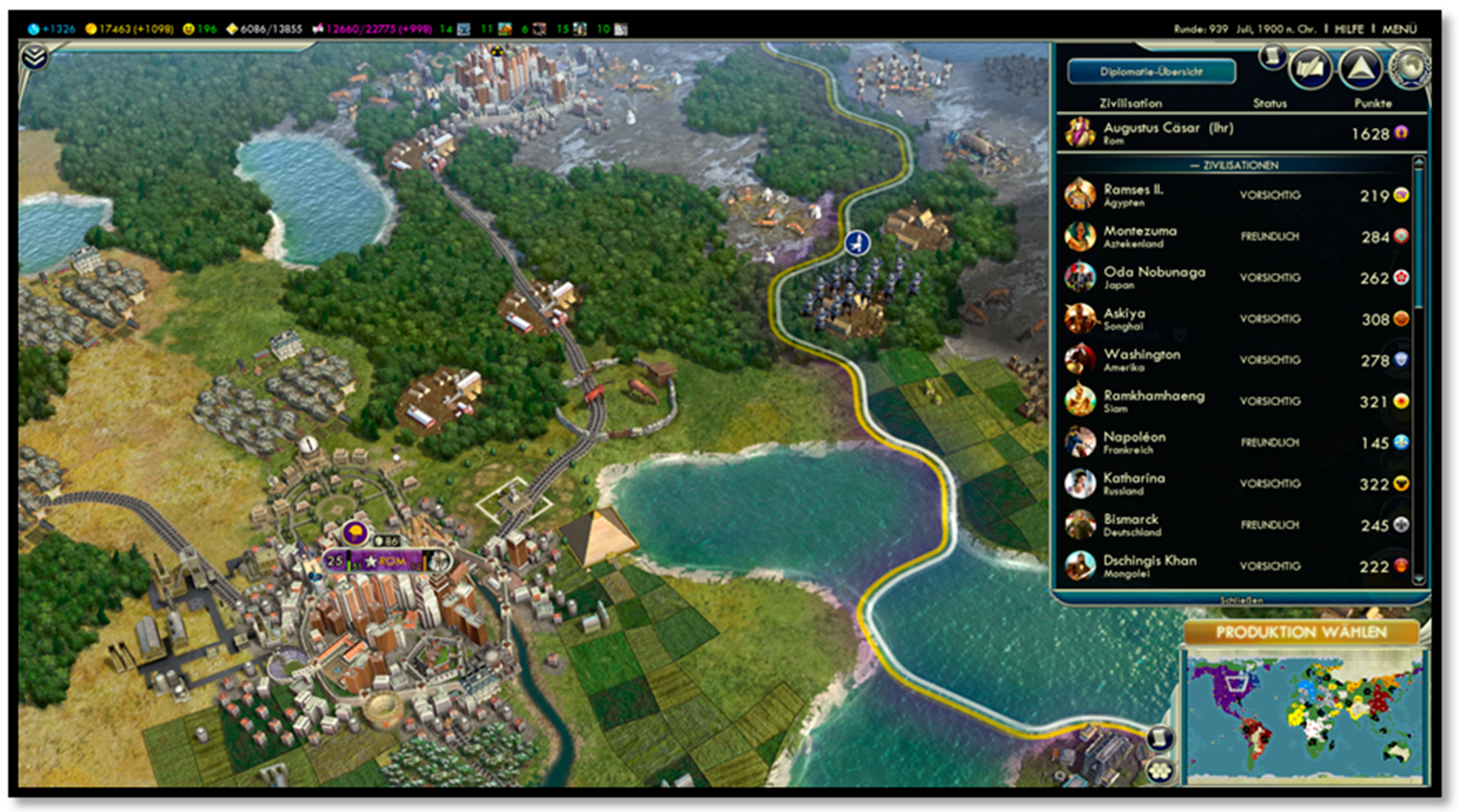
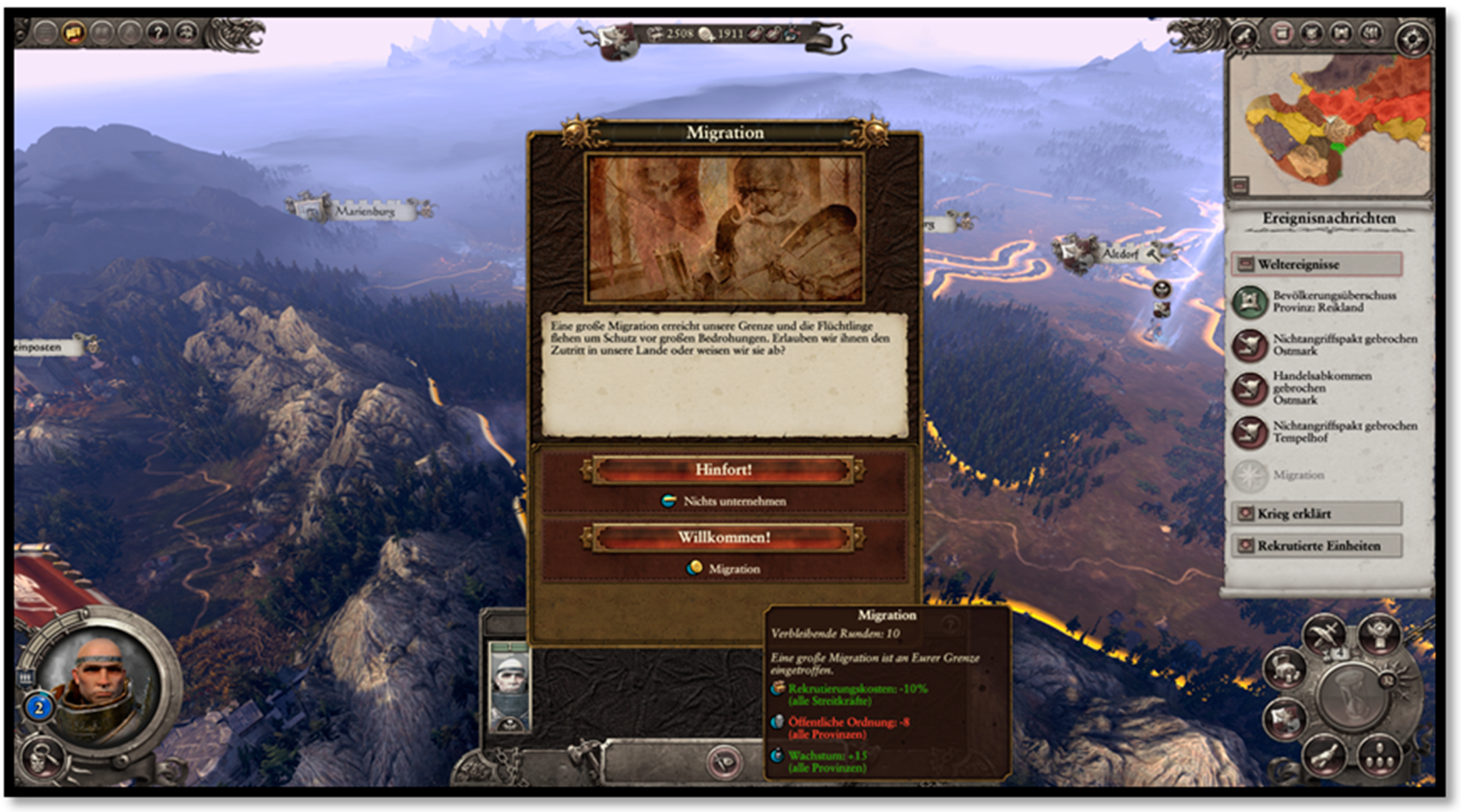
3.1. Results of the Game Analysis
3.2. Results of the Interview-Analysis
Interviewer: “Are there limits at the beginning of the game?”
No. 5: “Yes, to my base here.”
Interviewer: “Where do boundaries become visible in the game?”
No. 1: “So you can build walls for protection. City walls, but they’re really just around the city. Or the Chinese Wall, it’s really visible at your border.”
Interviewer: “What’s with the colours?”
No. 7: “Well, the border itself has no colour, it just has this colour marking of your nation and this transparent shimmer.”
No. 3: “This dotted line means that it is not from a civilization but from a city-state”.
No. 6: “So in the real world, boundaries in the real world, in connection with the game, in both the boundaries are not directly visible, so I just don’t know exactly where the boundary of my territory is. You don’t actually see them in real life either, so highest with signs but not if I’m in Germany or Holland.”
Interviewer: “So sometimes you also use that when you really want to start a war with someone in order to provoke them?”
No. 3: “What I mostly do is, I gather my troops at his border and then the person comes to me, asks, why are you doing this? And then I can either choose, yes, my troops just want to pass by. […]. And then there are things, you’ve found out my plan, and then I can go straight into his territory.”
No. 1: “So if you have a well-developed area here, you think I’ll do something else now. But now you have another strong nation next to you. If you think yes, okay, then I start to explore the sea. If you find islands, you’ll expand your area like this. Of course, you can now compare that with the colonial period, in which Europe was already relatively densely populated.”
No. 2: “I mean, in the beginning, I suppose, was it also the case that one tried to take as much as possible for oneself. At the first beginnings of countries. Therefore, I mean, in itself it makes sense for the nation at the beginning to spread as far as possible.”
No. 8: “I mean, in every respect it has a practical advantage to extend borders and claim more, because more resources, more power. You have to become practically bigger.”
No. 5: “Now I can, for example, here, that is also very important. There is also this sensor tower here. It shows the locations of enemy towers and the radius you can see. That’s also part of this map control.”
No. 2: “And it’s also easier to defend, because you’re in your territory. In theory, you can heal the damage that happens to you. But those who attack have to move from their borders to your borders first. That’s why you have the advantage of having a city wall. It can shoot at your opponent, I say now”.
No. 4: “As a Terran, it’s very interesting to build up this access first”.
3.3. Reflection and Comparison of Boundaries Inside and Outside the Game
“For example, the Germans, they have an advantage in the economy. Makes sense […] For example, Russia has such an advantage. That if the one city bets that the two terrain fields get directly in addition. Which makes sense because Russia is huge.”
No. 5: “I wouldn’t start a war right now. But in the game, I can’t communicate with the enemy and try to find other ways. So, because in real life there are other ways to deal with the other and talk about it, which is a big difference between game and reality.”
4. Discussion
- In the first step pupils should first look at and describe the representations of borders. The key questions for the students are: How are boundaries represented in the game? Which functions have boundaries in the game? This can be done, for example, by forming groups in which a student who knows the games starts a session while the rest of the group makes observations. If no player is part of the class, let’s-play-videos or screenshots can be used as replacements.
- In the second step a comparison should take place against the background of the theoretical patterns of interpretation (spatial, border concepts, etc.) These observations and descriptions should be compared with the theoretical background introduced before the analysis. For the students, this would mean investigating where the representations of boundaries in the games coincide with the collected prior knowledge and where differences exist. As part of this comparison, students should answer the following key questions: Which representations of boundaries as well as their characteristics and functions, which we discussed at the beginning, can be found in the games? And which ones cannot be found? A simple, relatively obvious example would be that boundaries on the Earth’s surface are not to be seen as coloured lines. The consequences would then have to be reflected in the following step.
- In the concluding third step, the reasons (game design, etc.) for the for these representations, for parallels and differences between game world and real earth surface can be discussed with the students in order to be able to classify such representations appropriately in the future. This section is about guiding students to a critical reflection of what is portrayed. The following guiding questions can serve this purpose: What is realistic and what is not about the representations of boundaries that you have studied? What can be the reasons why some characteristics and functions of boundaries are not represented? The goal in this phase should be to convey to the students that even a popular medium like a video game can transport geopolitical meanings, but that these are often limited by game design and not easily transferable to reality.
5. Conclusions
Author Contributions
Funding
Conflicts of Interest
References
- Seidel, S.; Budke, A. Keine Räume ohne Grenzen. Typen von Raumgrenzen für den Geographieunterricht. Zeitschrift für didaktik der Gesellschaftswissenschaften 2017, 2, 41–59. [Google Scholar]
- Deutsche Gesellschaft für Geographie (DGfG) (Ed.) Bildungsstandards im Fach Geographie für den Mittleren Schulabschluss; Self-Published: Bonn, Germany, 2017. [Google Scholar]
- Medienpädagogischer Forschungsverbund Südwest (mpfs). JIM-Studie 2018. In Jugend, Information, Basisuntersuchung zum Medienumgang 12- bis 19-jährige; Self-published: Stuttgart, Germany, 2018. [Google Scholar]
- Gryl, I.; Horn, M.; Schweizer, K.; Kanwischer, D.; Rhode-Jüchtern, T. Reflexion und Metaperspektive als notwendige Komponenten der Kartenkompetenz. Geographie und ihre Didaktik 2010, 38, 172–179. [Google Scholar]
- Gryl, I. Geographielehrende, Reflexivität und Geomedien. Zur Konstruktion einer empirisch begründeten Typologie. Geographie und ihre Didaktik 2012, 4, 161–183. [Google Scholar]
- Dewey, J. Experience and Education; Kappa Delta Pi: Indianapolis, IN, USA, 1938. [Google Scholar]
- Kerres, M.; Bormann, M.; Vervenne, M. Didaktische Konzeption von Serious Games: Zur Verknüpfung von Spiel- und Lernangeboten. Zeitschrift für Theorie und Praxis der Medienbildung Occasional Papers 2009, 1–16. [Google Scholar] [CrossRef] [Green Version]
- Fromme, J.; Könitz, C. Bildungspotenziale von Computerspielen-Überlegungen zur Analyse und bildungstheoretischen Einschätzung eines hybriden Medienphänomens. In Perspektiven der Medienbildung; Marotzki, W., Meder, N., Eds.; Springer VS: Wiesbaden, Germany, 2014; pp. 235–286. [Google Scholar]
- Ó. Tuathail, G. Critical Geopolitics: The Politics of Writing Global Space; University Press of Minnesota: Minneapolis, MN, USA, 1996. [Google Scholar]
- Dittmer, J.; Gray, N. Popular Geopolitics 2.0: Towards New Methodologies of the Everyday. Geogr. Compass 2010, 4, 1664–1677. [Google Scholar] [CrossRef]
- Adams, P.C. Television as Gathering Place. Ann. Assoc. Am. Geogr. 1992, 82, 117–135. [Google Scholar] [CrossRef]
- Dittmer, J. Popular Culture, Geopolitics, & Identity; Rowmann & Littlefield: Lanham, MD, USA, 2010. [Google Scholar]
- Schwartz, L. Fantasy, Realism, and the Other in Recent Video Games. Space Cult. 2006, 9, 313–325. [Google Scholar] [CrossRef]
- Salter, M.B. The geographical imaginations of video Games: Diplomacy, Civilization, America’s Army and Grand Theft Auto IV. Geopolitics 2011, 16, 359–388. [Google Scholar] [CrossRef]
- Gregory, D. The Colonial Present: Afghanistan, Palestine, Iraq; Blackwell: Oxford, UK, 2004. [Google Scholar]
- Shaw, I.G.R.; Warf, B. Worlds of Affect: Virtual Geographies of Video Games. Environ. Plan. A Econ. Space 2009, 41, 1332–1343. [Google Scholar] [CrossRef] [Green Version]
- Bos, D. Answering the Call of Duty: Everyday encounters with the popular geopolitics of military-themed videogames. Political Geogr. 2018, 63, 54–64. [Google Scholar] [CrossRef]
- Jörissen, B.; Marotzki, W. Dimensionen strukturaler Medienbildung. In Medienbildung–Eine Einführung; Jörissen, B., Marotzki, W., Eds.; Klinkhardt: Bad Heilbrunn, Germany, 2009; pp. 30–40. [Google Scholar]
- Connolly, T.M.; Boyle, E.A.; MacArthur, E.; Hainey, T.; Boyle, J.M. A systematic literature review of empirical evidence on computer games and serious games. Comput. Educ. 2012, 59, 661–686. [Google Scholar] [CrossRef]
- Boyle, E.A.; Hainey, T.; Connolly, T.M.; Gray, G.; Earp, J.; Ott, M.; Lim, T.; Ninaus, M.; Ribeiro, C.; Pereira, J. An update to the systematic literature review of empirical evidence of the impacts and outcomes of computer games and serious games. Comput. Educ. 2016, 94, 178–192. [Google Scholar] [CrossRef]
- Fromme, J.; Jörissen, B.; Unger, A. Bildungspotenziale digitaler Spiele und Spielkulturen. Zeitschrift für Theorie und Praxis der Medienbildung 2008, 15, 1–23. [Google Scholar]
- De Grove, F.; Van Looy, J.; Neys, J.; Jansz, J. Playing in school or at home? An exploration of the effects of context on educational game experience. Electron. J. E Learn. 2012, 10, 199–208. [Google Scholar]
- Raudonat, K. Sozial-kommunikative Kompetenzen im Kontext von Online-Rollenspielen am Beispiel von Kommunikation und Interaktion im Rahmen von Spielhandlungen in dem MMORPG World of Warcraft; Self-published: Hamburg, Germany, 2017. [Google Scholar]
- Fritz, J. Wie Computerspieler ins Spiel Kommen; Theorien und Modelle zur Nutzung und Wirkung virtueller Spielwelten; Vistas: Berlin, Germany, 2011. [Google Scholar]
- Agnew, J.A.; Mamadouh, V.; Secor, A.J.; Sharp, J.P. (Eds.) The Wiley Blackwell Companion to Political Geography; Wiley: New York, NY, USA, 2015. [Google Scholar]
- Murphy, A.B. Territory’s continuing allure. Ann. Assoc. Am. Geogr. 2013, 103, 1212–1226. [Google Scholar] [CrossRef]
- Agnew, J. The territorial trap: The geographical assumptions of international relations theory. Rev. Int. Political Econ. 1994, 1, 53–80. [Google Scholar] [CrossRef]
- Wardenga, U. Räume der Geographie und zu Raumbegriffen im Geographieunterricht. Geogr. Heute 2002, 200, 8–11. [Google Scholar]
- Paasi, A. Territories, Boundaries, and Consciousness: The Changing Geographies of the Finnish-Russian Boundary; J. Wiley & Sons: New York, NY, USA, 1996. [Google Scholar]
- Newman, D.; Paasi, A. Fences and neighbours in the postmodern world: Boundary narratives in political geography. Prog. Hum. Geogr. 1998, 22, 186–207. [Google Scholar] [CrossRef]
- Popescu, G. Bordering and Ordering the Twenty-first Century: Understanding Borders; Rowman&Littlefield: Lanham, MD, USA, 2011. [Google Scholar]
- Werlen, B. Sozialgeographie: Eine Einführung; Haupt: Bern, Switzerland, 2008. [Google Scholar]
- Konrad, K. Lautes Denken. In Handbuch Qualitative Forschung in der Psychologie; Mey, G., Mruck, K., Eds.; Springer: Wiesbaden, Germany, 2010; pp. 476–490. [Google Scholar]
- Ash, J.; Gallacher, L.A. Cultural Geography and Videogames. Geogr. Compass 2011, 5, 351–368. [Google Scholar] [CrossRef] [Green Version]
- Amilhat-Szary, A.L. Boundaries and Borders. In The Wiley Blackwell Companion to Political Geography; Agnew, J.A., Mamadouh, V., Secor, A., Sharp, J.P., Eds.; Wiley: New York, NY, USA, 2015; pp. 13–25. [Google Scholar]
- Mayring, P. Qualitative Inhaltsanalyse. Grundlagen und Techniken; Beltz: Weinheim, Germany, 2015. [Google Scholar]
- Gryl, I.; Kanwischer, D. Geomedien und Kompetenzentwicklung. Ein Modell zur reflexiven Kartenarbeit im Unterricht. Zeitschrift für Didaktik der Naturwissenschaften 2011, 17, 177–202. [Google Scholar]
- Adams, E. Fundamentals of Game Design; New Riders: San Francisco, CA, USA, 2014. [Google Scholar]
- Waltz, K. Realism and International Politics; Routledge: New York, NY, USA, 2008. [Google Scholar]
- Mearsheimer, J.J. The Tragedy of Great Power Politics; W.W. Norton & Company: New York, NY, USA, 2001. [Google Scholar]
- Massey, D.; Allen, J. Geography matters! A reader; Cambridge University Press: Cambridge, UK, 1994. [Google Scholar]
- Soja, E. Thirdspace: Journeys to Los Angeles and other Real and Imagined Places; Blackwell Publishers Ltd.: Cambridge, UK, 1996. [Google Scholar]
- Brenner, N. Tausend Blätter. Bemerkungen zu den Geographien ungleicher räumlicher Entwicklung. In Politics of Scale. Räume der Globalisierung und Perspektiven emanzipatorischer Politik; Wissen, M., Röttger, B., Heeg, S., Eds.; Westfälisches Dampfboot: Münster, Germany, 2008; pp. 57–84. [Google Scholar]
- Seidel, S.; Budke, A. “A border is a Ban”-Students’ Conceptual Understanding and Experiences of Europe’s Borders and Boundaries. Rev. Int. Geogr. Educ. Online RIGEO 2019, 9, 82–101. [Google Scholar] [CrossRef]
- Lee, J.K.; Probert, J. Civilization III and whole-class play in high school social studies. J. Soc. Stud. Res. 2010, 34, 1–28. [Google Scholar]
- Baetge, C.; Ganguin, S. Games in der Schule: Potenziale und Herausforderungen. In Make, Create & Play Medienpädagogik Zwischen Kreativität und Spiel; Von Gross, F., Röllecke, R., Eds.; Kopaed: München, Germany, 2018; pp. 39–45. [Google Scholar]


| No. | Age | Gender | Game |
|---|---|---|---|
| 1 | 15 | Male | Civilization V |
| 2 | 16 | Male | Civilization V |
| 3 | 15 | Male | Civilization V |
| 4 | 17 | Male | Starcraft 2 |
| 5 | 16 | Male | Starcraft 2 |
| 6 | 19 | Male | Starcraft 2 |
| 7 | 18 | Male | Total War: Warhammer |
| 8 | 18 | Male | Total War: Warhammer |
| Category | Codes with Explanations: |
|---|---|
| Existence of borders and territories at the start of the game | 0 = The expansion of one’s own borders or territory is mentioned in the game objectives. 1 = At the beginning of the game, the playing field is restricted to a single area, while the rest of the playing field is not visible or covered. 2 = In the game there is a map with given regions and their borders, which can be controlled. 3 = The playing field is designed in such a way that the playing pieces cannot move everywhere, and the players cannot see everything; limitations of the playing world prevent them from moving |
| Visualization of borders and territories during the game | 0 = No visible boundary lines. 1 = Borders are displayed as (dashed) lines on the playing field 2 = Territories and their borders are coloured differently 3 = Territories are distinguishable and delimited from each other by different surfaces. 4 = Fences, walls and similar boundaries mark the area of influence. 5 = Regions and territories have names, and thus distinguish themselves from others. 6 = Fog of War = only your own sphere of influence is permanently visible, other areas are delimited by “fog”. |
| Consequences of border crossings in the game | 1 = A border crossing leads (a) immediately to a battle or (b) to a deterioration of relations with the other party up to and including war. 2 = If your own game pieces hit the territory of another game party, this leads to negotiations. |
| Border practices in the game | 1 = fix = erect fences, walls, watchtowers, etc. 2 = control = use of figures and observation of the border to detect crossings. 3 = Actions with the aim of changing the boundary line. 5 = negotiate = all actions with the aim to change the meaning of the border (e.g., in terms of permeability). 6 = Actions which, by naming their own territory, distinguish it from others. |
© 2019 by the authors. Licensee MDPI, Basel, Switzerland. This article is an open access article distributed under the terms and conditions of the Creative Commons Attribution (CC BY) license (http://creativecommons.org/licenses/by/4.0/).
Share and Cite
Seidel, S.; Bettinger, P.; Budke, A. Representations and Concepts of Borders in Digital Strategy Games and Their Potential for Political Education in Geography Teaching. Educ. Sci. 2020, 10, 10. https://doi.org/10.3390/educsci10010010
Seidel S, Bettinger P, Budke A. Representations and Concepts of Borders in Digital Strategy Games and Their Potential for Political Education in Geography Teaching. Education Sciences. 2020; 10(1):10. https://doi.org/10.3390/educsci10010010
Chicago/Turabian StyleSeidel, Sebastian, Patrick Bettinger, and Alexandra Budke. 2020. "Representations and Concepts of Borders in Digital Strategy Games and Their Potential for Political Education in Geography Teaching" Education Sciences 10, no. 1: 10. https://doi.org/10.3390/educsci10010010
APA StyleSeidel, S., Bettinger, P., & Budke, A. (2020). Representations and Concepts of Borders in Digital Strategy Games and Their Potential for Political Education in Geography Teaching. Education Sciences, 10(1), 10. https://doi.org/10.3390/educsci10010010