1. Introduction
With the rapid development of urban areas and the increasing demand for parking lot monitoring, automatic parking assessment has become an important part of intelligent transportation network. This work explicitly targets the task of binary parking-slot occupancy detection (classifying each slot as vacant or occupied) from UAV aerial imagery and does not involve fine-grained vehicle attribute recognition such as vehicle type, shape or color. Vision-based methods are very interesting because they can provide real-time information about occupied space without a lot of hardware like embedded sensors. Compared with fixed surveillance cameras that are pre-installed in parking lots, UAV-based detection has three distinct advantages: (1) flexible on-demand deployment, which is especially valuable for temporary parking lots and large-scale open parking areas where laying camera infrastructure is costly or impractical; (2) wide-area coverage, as a single drone can quickly survey an entire parking lot of hundreds of spaces in one flight; (3) independence from field power and communication wiring, which reduces deployment cost and improves system mobility. These advantages make UAV-based parking inspection a meaningful complement to fixed camera systems.
In this respect, drones have great advantages over fixed cameras, because they can easily monitor large parking lots from the sky or almost vertically. These functions are very useful for monitoring each parking space, observing vehicle driving and quickly evaluating the whole scene. However, the detection of UAV is still difficult, because the targets are usually small, very close to each other, sometimes hidden, and seriously affected by camera angle, background confusion and light changes [
1,
2]. Although the task is formally a binary classification per slot, the extremely small target size, dense arrangement and severe perspective distortion in UAV imagery make generic detectors prone to missed detections, boundary misalignment and counting errors. Therefore, targeted architectural improvements are still necessary to achieve reliable detection accuracy for practical parking management.
In recent years, the main research in this field has changed from the traditional parking space identification method to the deep learning method that can directly identify vehicles or parking areas. The development of public datasets is very important in this respect. For example, PKLot provides a comprehensive and reliable collection for evaluating the availability of parking spaces under different lighting and visual angles, while CARPK provides a large number of sky view annotations and shows the value of using regular organization to park vehicles [
3,
4]. These tools allow widespread use of YOLO and other detectors in one step. Their attraction lies in their good balance between detection accuracy and calculation speed, which is very important for real-time applications, such as mass parking monitoring and drone operation [
5]. However, the standard version of YOLO is not specially made for the needs of parking space detection of unmanned aerial vehicles, which makes them have poor performance in detecting small rectangular objects. At the same time, transformer-based detectors such as DETR have improved performance in crowded scenes by modeling global context, broadening the methods available for parking-slot and aerial-image analysis [
6].
Despite recent progress, UAV-based parking-slot detection still faces several key challenges. First of all, at present, most detectors are made for general objects instead of long and regular parking spaces, which requires accurate edge alignment and constant proportion. Then, methods such as CBAM and EMA using attention are helpful to extract features, but they are still general and do not fully consider the repeated patterns that are often seen in parking space setting [
7,
8]. In addition, the classical regression method focusing on IoU gives priority to overlap, but has little control over the accuracy of center, shape uniformity, perimeter alignment and aspect ratio. These shortcomings are more obvious in the images taken by drones, where the objects are very small, very close to each other, and usually require little calculation to deal with, which can prevent the use of too heavy architecture or too complicated detection framework [
1,
2,
5,
7,
8,
9].
To address these challenges, we propose an improved YOLOv11n for parking space detection in aerial drone images. The model is designed to remain lightweight while improving feature extraction, attention, and bounding-box prediction for overhead parking lot scenes. Specifically, the new architecture replaces the standard backbone with a feature extractor inspired by MnasNet. This improves the efficiency of multi-scale calculation and functional learning. It also adds enhanced EMA components to better capture the details of crowded or hidden areas. It uses geometry-aware UIoU+ loss function to make the position of rectangular slot more accurate. Together, these advances have solved the main challenges of the application: managing small targets, ensuring the robustness of structured obstacles, and allowing deployment on UAV platforms with few resources [
8,
10].
The main innovations of this work are as follows:
Task-specific lightweight multi-scale backbone: Lightweight structure inspired by MnasNet, using a mixture of 3 × 3 and 5 × 5 deep convolution and gating attention. This method improves the ability of the model to identify small air targets of different scales, while maintaining low computational requirements.
Structure-aware improved EMA module: The enhanced EMA module, with adaptive group segmentation, frequency-domain addition and controlled fusion technology, aims to explicitly model repetitive scheduling as typical rows and columns of a parking-slot plan.
Geometry-aware UIoU+ regression loss: The UIoU+ loss formula considers geometry and combines four different geometric constraints and a dynamic weighting strategy based on WIoU. This greatly improves the positioning accuracy of the edge of rectangular parking spaces.
Comprehensive validation and reproducible implementation: Extensive verification of three benchmark datasets proves that our method far exceeds the performance of existing light detectors, while maintaining the real-time reasoning ability of vehicle-borne UAV system.
The above three technical components constitute the core innovations of this work. The inverted residual structure, squeeze-and-excitation channel recalibration, and mixed depthwise convolution kernels are internal implementation details of the MnasNet-inspired backbone, rather than additional independent innovations. They work together to support the lightweight multi-scale feature extraction capability of the backbone.
Beyond the core innovations, the new core architecture also includes reverse residual block, channel readjustment mechanism inspired by squeeze-and-exclusion operation, and parallel deep convolution using 3 × 3 and 5 × 5 cores. This improves the diversity of the receiving field without increasing the calculation work [
10,
11]. On this basis, the improved EMA module performs better than the old module by using adaptive clustering for separation, adding an FFT-based frequency domain in 2D and an adaptive gate mechanism for multi-scale fusion. This is helpful in better expressing the relationship between the periodic arrangement of parking teams and ladders [
8]. In addition, the new UIoU+ loss function combines the adaptive weight strategy with four geometric constraints. These constraints include distance ratio between centers, shape deviation, perimeter difference and elongation error. This ensures better alignment with the rectangular shape of the parking lot. These three key elements are designed to work together: the infrastructure generates more unique multi-scale features, the module selectively highlights relevant structural information, and the loss function transforms these features into more accurate regression results [
8,
10,
11].
The results of the proposed framework are tested with three different datasets: a customized UAV parking batch dataset containing 2150 images, CARPK and PKLot [
3,
4]. This method has produced very good results. It reached 99.44% mAP@0.5 and 90.31% mAP@0.5:0.95 in UAV assembly, 97.85% mAP@0.5 in CARPK and 98.12% mAP@0.5 in PKLot. In addition, the model is very effective. It is small, only 6.01 MB, and fast. It can process 52 FPS images in real time with 640 × 640 images on NVIDIA Jetson Orin NX equipment. Ablation tests show that the backbone of MnasNet, enhanced EMA and UIoU+ loss function are all helpful in improving performance. In other words, these results show that the proposed design provides a good balance between accuracy and speed. It is a practical tool for accurate detection of parking spaces of unmanned aerial vehicles in intelligent transportation environment.
2. Related Work
2.1. General Paradigm of UAV-Based Parking and Parking-Slot Detection
Most studies in UAV-based parking analysis follow a common technical paradigm. A real-time detector is first adopted as the main perception framework, usually with multi-scale feature aggregation to preserve small targets in aerial images. In order to improve performance, attention module or context modeling is used to reduce the problems of background elements and closures, while loose regression based on IoU precisely adjusts localization. In the background of parking lot application, a benchmark dataset is very important for establishing this research direction. Hsieh et al. [
3] put forward the CARPK dataset, which shows that parking images taken from the sky show specific spatial patterns, which can be used to improve positioning and counting. Almeida et al. [
4] created PKLot to evaluate the occupancy of parking spaces from different times and angles, which shows that the system must be able to adapt to a changing environment. In other words, these important works show that successful parking-lot analysis requires accurate detection and clear management of structured scenes, scale changes and actual deployment restrictions. However, the current methods rarely combine these three aspects into a simple and effective system, which urges us to develop a detector specially used to detect the parking space of drones.
2.2. Lightweight YOLO-Based Detection and Efficient Feature Extraction
Within this paradigm, YOLO-series single-stage detectors are the first choice because of their good balance between accuracy and reasoning speed. Jocher et al. [
12] formalized the Ultralytics YOLOv11 framework into a real-time practical benchmark, which was specially designed for deployment-oriented detection. On this basis, Ge et al. [
13] introduced YOLOX, which replaced the traditional fixed-point based method with a fixed-point design and separation detector, resulting in better optimization and better overall detection performance. In order to continue this trend, Tian et al. [
14] developed YOLOv12, and guided the YOLO family to the attention-centered architecture, seeking to improve the rendering ability while maintaining real-time efficiency. At the same time, Zhao et al. [
15] used RT-DETR to prove that detection based on end-to-end transformer can match real-time performance by minimizing the dependence on post-processing technologies such as non-maximum deletion.
From the perspective of efficient backbone network, Tan et al. [
10] introduced MnasNet, which tried to balance the accuracy and delay of mobile platform by using neural search architecture for specific hardware. This method is especially important for the UAV system, because the on-board computing resources are limited by power and memory constraints. In the field of unmanned aerial vehicles, Chen et al. [
16] focus on the detection of light objects in aerial view, emphasizing the necessity of minimizing computational requirements without sacrificing performance. At the same time, Amato et al. [
17] verified the ability of deep learning to identify busy parking spaces, and Liu et al. [
18] pointed out that the simplified single-stage detector performed well in real-time vision applications, which means that the lightweight detection method can be applied to parking lot environment.
Compared with the previous general detectors, these advances improve the efficiency, deployment convenience or small object detection. However, their main focus is on extensive object detection, ignoring the unique difficulties of tiny targets, rectangular form and unified parking configuration in parking space detection based on drones. Our research fills this gap by combining the efficient architecture of MnasNet with custom modification for parking space detection.
2.3. Attention and Context Modeling for Occlusion and Structured Parking Scenes
In order to solve the less obvious details in a complex or highly crowded environment, many researchers use attention technology to better understand the context. Woo et al. [
7] created CBAM, which is a method to improve the feature response by paying attention to the channel and space, and will not increase the calculation cost too much. Different from simple convolution improvement, CBAM makes the function more selective by amplifying the most important channels and spatial regions. By continuing this work, Ouyang et al. [
8] put forward efficient multi-scale attention (EMA), which is helpful for learning across different spatial domains and allows functional integration at multiple scales without losing too much information due to excessive channel compression. Therefore, EMA is an improvement on the old lightweight attention framework, because it strengthens the connection between different functional dimensions and enhances contextual interaction at different scales.
At the same time as the CNN-centered attention mechanism, Carion et al. [
6] proposed DETR. They changed their view of object detection, regarded it as an overall prediction task, and directly captured global dependencies by using transformers. This method helps to reason better over long distances and reduces the need for many manual steps in this process. On this basis, Zhao et al. [
15] used transformers for real-time applications, while Tian et al. [
14] showed how to integrate attention into the high-efficiency architecture based on YOLO, beyond the framework using only resource-intensive transformers.
Compared with CBAM, EMA improves multi-scale context merging. Compared with the traditional CNN detector, the method based on DETR provides a better understanding of the overall environment. However, these technologies are still very universal, without considering the natural periodicity of lines and columns of parking spaces or the patterns of frequency areas that are often seen in aerial views of parking lots. This difference inspired our customized EMA module, which was specially optimized for the structured parking environment.
2.4. Bounding-Box Regression and Geometry-Aware Localization
A major challenge is still localization, because parking spaces are not standard objects; They have slender and definite shapes and are very sensitive to boundary differences. The early loss function based on intersection improved the thinning of overlap, but when there are few or no intersections between the prediction and the actual frame, they have problems. In response, Rezatofighi et al. [
19] introduced the generalized intersection over union (Giou), which added a coverage area component to better handle the non-overlapping situation. On this basis, Zheng et al. [
20] developed distance IoU and complete IoU, which increased the penalty of center distance and aspect ratio to improve the convergence and accuracy of bounding box. Compared with GIoU, the following loss function pays more attention to geometric features, not just overlap.
Recent progress has greatly improved the general object detection system. Many modern YOLO detectors use sophisticated IoU loss functions. However, parking space detection needs more accurate geometric constraints. Hsieh et al. [
3] show that the parking lot environment has different structural patterns. Earlier research shows that location detection benefits from the method of coordinating the characteristics of specific scenes with processing efficiency [
17,
18].
2.5. Summary and Relation to the Present Work
In a word, prior research has made substantial progress in three main areas. First, researchers including Jocher et al. [
21], Ge et al. [
22], Tian et al. [
12], and Chen et al. [
16] have improved the performance and practicality of real-time perception systems by advancing detection architectures or optimizing lightweight networks for deployment. Second, Woo et al. [
7], Ouyang et al. [
8], Carion et al. [
6], and Zhao et al. [
15] have strengthened contextual reasoning by introducing attention mechanisms or transformer-based global modeling. Third, Rezatofighi et al. [
19] and Zheng et al. [
20] have improved bounding-box regression by introducing more informative geometric constraints beyond plain IoU optimization.
Despite these advances, the three lines of work are usually developed separately. Most existing lightweight YOLO-based detection frameworks only perform isolated module optimizations for general object detection, such as replacing backbones for efficiency or adding attention modules for general context enhancement, without considering the unique coupling relationship between small-target features, structured scene patterns, and rectangular geometric attributes in UAV parking-slot detection tasks. Few studies jointly address lightweight multi-scale feature extraction for small UAV targets, structure-aware attention for periodic parking-slot layouts, and geometry-aware regression tailored to rectangular slots within a single unified framework.
Inspired by these observations, our method combines a MnasNet-inspired backbone for efficient feature extraction, an improved EMA module for adaptive cross-scale and frequency-aware enhancement, and a UIoU+ loss for geometry-constrained parking-slot regression in a unified YOLOv11n framework. Different from simple module stacking, the three components are collaboratively designed for the parking-slot detection task: the backbone generates task-adaptive multi-scale features, the attention module enhances structured pattern perception based on these features, and the loss function converts enhanced features into high-precision rectangular bounding-box predictions. This coordinated optimization mechanism brings synergistic performance gains that cannot be achieved by isolated module upgrades. In this way, the proposed method is not a simple accumulation of modules, but a task-oriented integration designed specifically for UAV-based parking-slot detection.
3. Proposed Method
This study uses an improved YOLOv11n for parking space localization in drone imagery. The design is driven by three characteristics of the task: small and densely arranged targets, strong directional and repetitive spatial patterns, and the rectangular shape of parking slots. To address these traits, the detector combines a MnasNet-inspired lightweight backbone, an improved EMA module, and an enhanced UIoU+ box loss. It keeps the efficient neck and head of YOLOv11n [
21], while replacing the backbone and regression loss and adding the attention module to the medium-scale branch.
3.1. Overall Framework
Given an input UAV image
, the detector extracts multi-scale features
through the proposed MnasNet-inspired backbone. These features are fused by the YOLOv11n neck, while the improved EMA module is applied to the P
4 branch to strengthen structure-aware responses before prediction. The P
4 branch is selected for its balance of spatial detail and semantic context, making it suitable for small and densely arranged parking slots with modest computational cost. The detection head finally produces classification scores and bounding-box coordinates at multiple scales. The forward process is formulated as
where
denotes the MnasNet-inspired backbone,
denotes the improved EMA module, and
denotes the remaining YOLOv11n neck and detection heads.
The total optimization objective keeps the classification and distributional regression terms of the YOLOv11n baseline and replaces the original box regression term with the proposed UIoU+ loss. The overall loss is
where
indexes the three detection scales and
controls the contribution of box regression, which is set to 7.5 in all experiments following the YOLOv11 default configuration.
From the architectural perspective, the backbone generates
,
, and
features for small, medium, and large objects, respectively. For an input size of 640 × 640, the corresponding spatial resolutions are 80 × 80, 40 × 40, and 20 × 20. Because parking slots in UAV imagery frequently appear as small-to-medium elongated regions, the
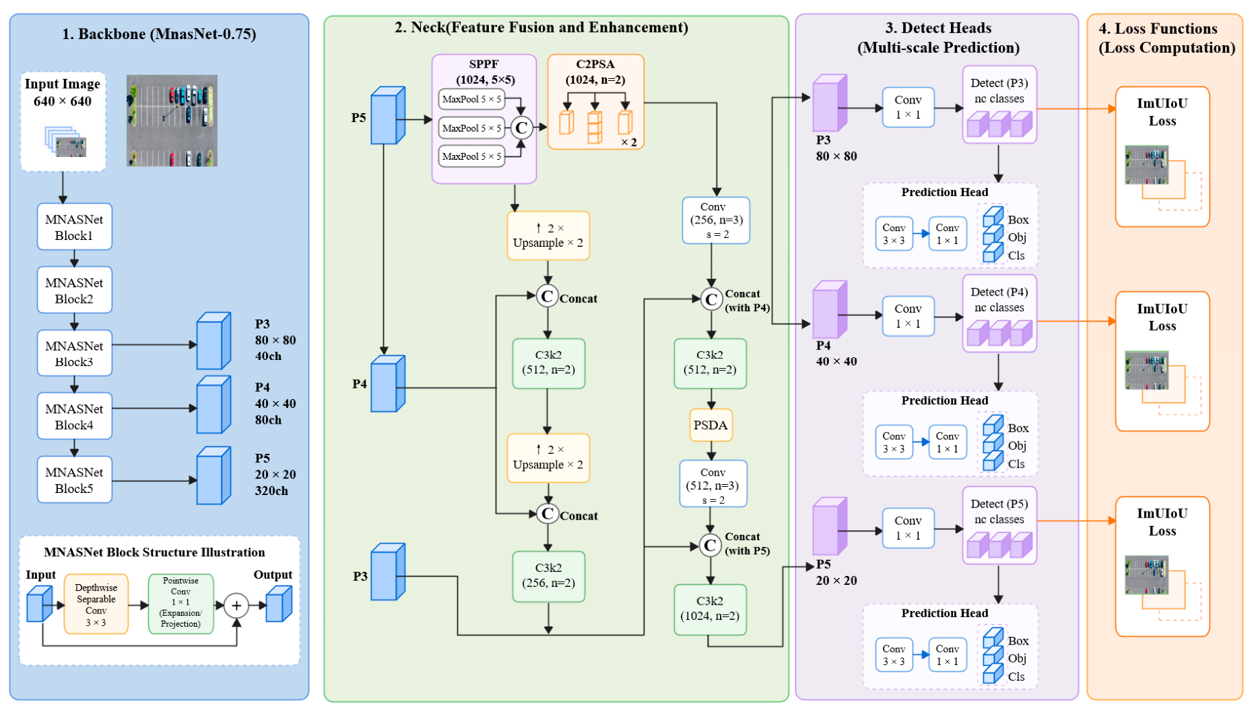
branch is especially important; hence, the improved EMA module is applied at this level to enhance contextual discrimination under dense occlusion and repetitive layouts. The overall architecture is illustrated in
Figure 1.
3.2. Basic Building Blocks
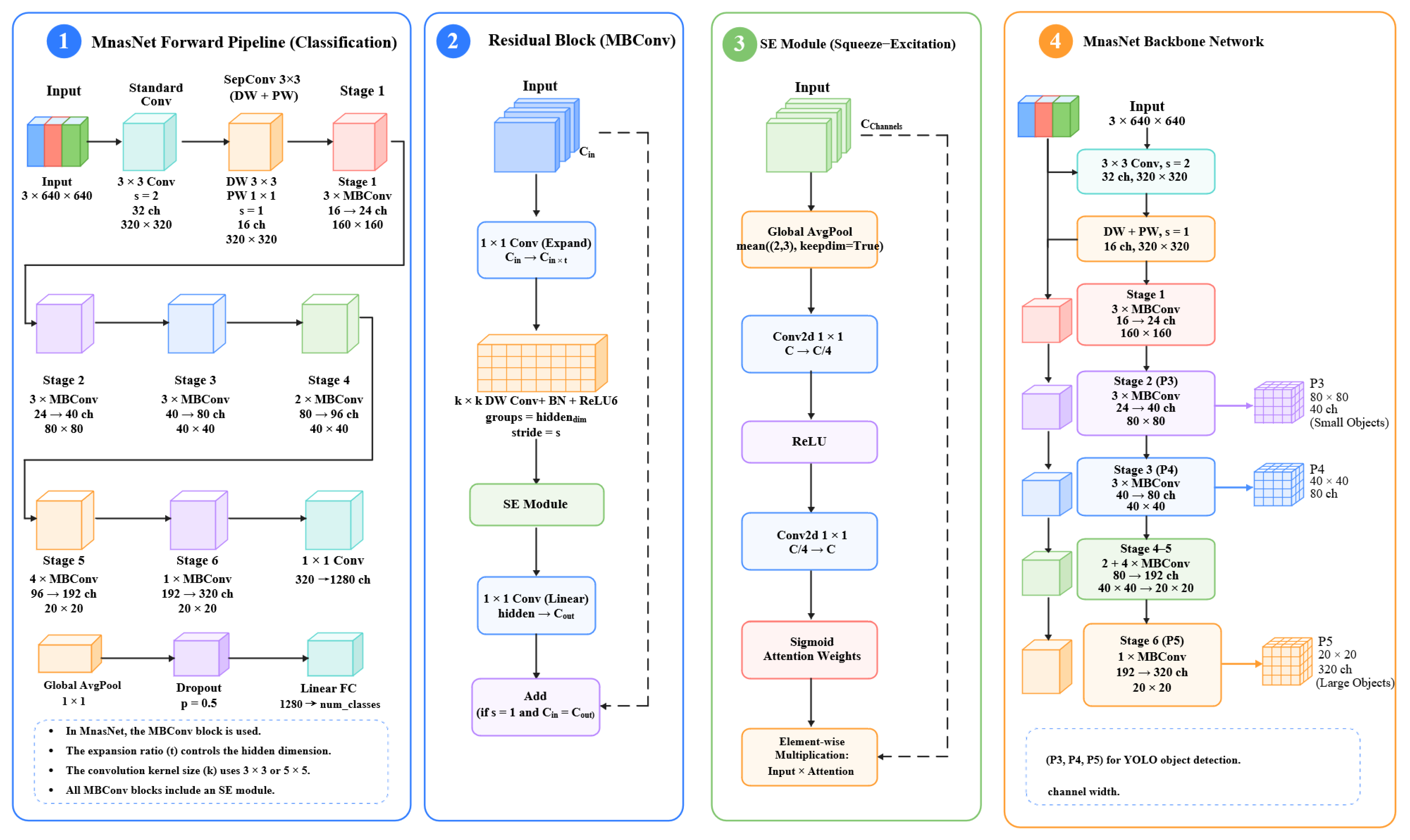
This method is built upon several effective components, including inverted bottleneck structures, depthwise-separable convolution operations, squeeze-and-excitation channel recalibration, strip-based attention functions, and frequency-based refinement techniques.
For a generic inverted residual bottleneck, the input feature
is first expanded by a pointwise convolution:
where
is the 1 × 1 expansion convolution, ∗ denotes convolution, and
is the ReLU6 activation. The expanded feature is then processed by a depthwise convolution:
where
denotes a depthwise convolution with kernel size
and stride
. Channel recalibration is achieved by an SE block:
where
is global average pooling,
is ReLU,
is Sigmoid, and
denotes element-wise multiplication. Finally, the projected output of the bottleneck is
where
is the linear 1 × 1 projection convolution.
By incorporating these basic building blocks, the proposed detector maintains strong representation capability without high computational cost, a key requirement for UAV deployment.
3.3. MnasNet-Inspired Lightweight Backbone
The default YOLOv11n backbone is replaced with a MnasNet-inspired backbone to strengthen multi-scale representation under limited computational budget. The backbone adopts a progressive down-sampling design composed of a stem convolution, a separable convolution, and multiple MBConv stages with mixed 3 × 3 and 5 × 5 depthwise kernels. Channel widths are adjusted by a width multiplier, enabling flexible deployment on different hardware budgets.
To maintain compatibility with the YOLO detection pipeline, the number of channel groups is scaled by a width multiplier
:
where
is the nominal channel width of the
l-th stage and
is set according to the target hardware. In the present implementation, the detector uses an MnasNet-0.75 style configuration.
The backbone starts with a 3 × 3 stem convolution and a separable 3 × 3 block, followed by six MBConv stages. The stage configuration is summarized in
Table 1. Stage 1 uses 3 × 3 depthwise kernels for efficiency in early low-level feature extraction, while Stage 2 uses 5 × 5 depthwise kernels to expand receptive field for small parking-slot targets. The stage configuration is summarized as follows: Stage 1 uses three MBConv blocks with
t = 3 and
k = 3, mapping 16 → 24 channels; Stage 2 uses three MBConv blocks with
t = 3 and
k = 5, mapping 24 → 40 channels and generating P3; Stage 3 uses three MBConv blocks with
t = 6 and
k = 5, mapping 40 → 80 channels and generating P4; Stage 4 uses two MBConv blocks with
t = 6 and
k = 3, mapping 80 → 96 channels; Stage 5 uses four MBConv blocks with
t = 6 and
k = 5, mapping 96 → 192 channels; Stage 6 uses one MBConv block with
t = 6 and
k = 3, mapping 192 → 320 channels and generating P5. The use of mixed 3 × 3 and 5 × 5 depthwise kernels improves receptive-field diversity, while the SE module embedded in each MBConv block enhances channel selectivity. Together, these designs strengthen multi-scale feature representation and make the backbone more suitable for aerial parking-slot detection.
The detailed structure of the MBConv building block is illustrated in
Figure 2.
3.4. Improved EMA Module
The original EMA module [
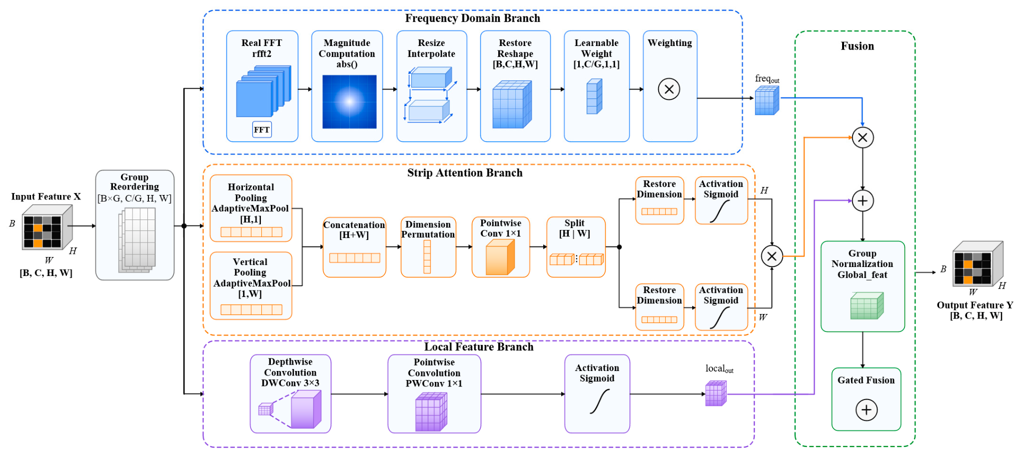
8] improves cross-spatial learning, but its standard form does not explicitly exploit the strong directional arrangement and periodic structure of parking slots. To address this limitation, the proposed improved EMA module introduces four changes: adaptive group partitioning, strip attention with max pooling, a depthwise-separable local branch, and a frequency-domain enhancement branch. The module architecture is shown in
Figure 3.
Let the input feature map be
. Instead of using a fixed group number, the module dynamically selects a valid group count according to the channel dimension:
where
is the maximum allowed number of groups, set to 8 in all experiments. The feature map is then rearranged as
3.4.1. Strip Attention Branch
The proposed strip attention branch differs from conventional band attention in that it performs directional pooling along both horizontal and vertical axes independently, generating long-strip attention maps that explicitly capture the row-column periodicity of parking-slot arrays. Conventional band attention typically operates on local band regions, while the strip attention used in this work covers the full spatial extent of each axis, making it more suitable for modeling the globally repeated layout of parking lots.
To capture parking-row regularity, the module performs horizontal and vertical strip pooling using adaptive max pooling. The pooled descriptors are concatenated and projected by a 1 × 1 convolution:
where
and
denote adaptive max pooling along the horizontal and vertical directions, respectively, and
is a 1 × 1 convolution. The strip-enhanced feature is then
Compared with average pooling, max pooling emphasizes peak activations and is therefore more suitable for dense parking scenes with highly similar local structures.
3.4.2. Local Feature Branch
In order to capture complex local details without spending too much, a branch using depthwise-separable convolution is added:
In this context, and represent 3 × 3 depth convolution and 1 × 1 point convolution, respectively. Compared with standard convolution, this branch is a more effective method to model the local neighborhood structure.
3.4.3. Frequency-Domain Enhancement Branch
Parking slots often display repeated geometric shapes. In order to simulate this high regularity, the introduced component uses the path in the frequency domain of the two-dimensional Fast Fourier Transform that is actually evaluated:
where
is the two-dimensional real FFT,
denotes amplitude extraction,
resizes the spectrum to the original spatial resolution, and
is a learnable channel-wise weight. This branch supplies global structural cues that are difficult to capture in the spatial domain alone.
3.4.4. Gated Fusion
The representation of global context can be created by combining the band attention feature with the frequency domain feature and homogenizing it. This representation is then used to adjust the local branch:
where
denotes Group Normalization. In this way, the final output combines directional attention, local structure, and global frequency information in a single lightweight module.
All abbreviations including BN (Batch Normalization), GAP (Global Average Pooling), GN (Group Normalization), DW (depthwise convolution), and rFFT2 (2D real Fast Fourier Transform) are uniformly typeset in Roman font throughout the manuscript to follow standard academic notation conventions.
3.5. Enhanced UIoU+ Loss for Rectangular Parking-Slot Regression
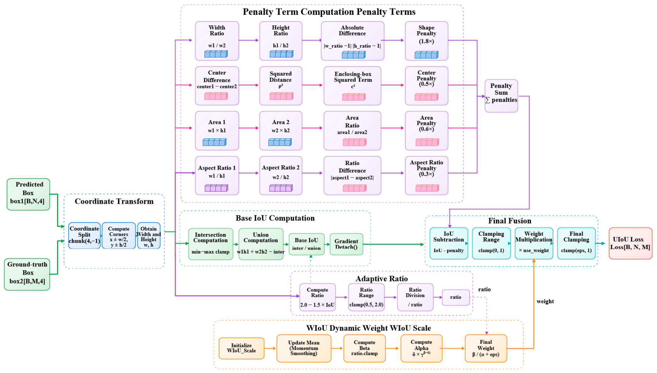
The regression of parking-slot boxes requires more than maximizing IoU, because parking slots are elongated and geometrically regular. Overlap-based losses alone may produce boxes with acceptable intersection but incorrect shape, area, or aspect ratio. To overcome this limitation, the proposed UIoU+ loss introduces adaptive ratio modulation and four geometry-aware penalty terms. The loss pipeline is illustrated in
Figure 4.
Let the predicted box and ground-truth box be
and
respectively. Their basic IoU is
An adaptive scaling ratio is then defined according to the current overlap:
This design applies stronger geometric relaxation when IoU is low (to stabilize early training) and tighter constraints when the prediction is already close to the target (to enable fine-grained late-stage refinement).
3.5.1. Center Distance Penalty
The normalized center distance penalty is defined as
where
is the Euclidean distance between box centers and
is the diagonal length of the minimum enclosing box of the two boxes. This term is already normalized to [0, 1] by the squared diagonal of the enclosing box.
3.5.2. Shape Consistency Penalty
To explicitly constrain width-height matching, the shape penalty is written as
The 1/2 factor normalizes the raw shape deviation to [0, 1] before applying the weight 1.8. Because parking slots are strongly rectangular, this term is assigned the largest coefficient among the four penalties to emphasize shape fidelity.
3.5.3. Area Consistency Penalty
The area ratio between the two boxes is constrained by
This term suppresses predictions whose overall scale is inconsistent with the ground truth.
3.5.4. Aspect-Ratio Penalty
To further preserve elongation characteristics, the aspect-ratio penalty is defined as
The final total penalty
P is computed as the sum of the four weighted terms and then globally clipped to [0, 1] to ensure numerical stability and physical interpretability:
This normalization resolves the original issue where unclipped penalty values could exceed the IoU range and produce negative loss inputs.
3.5.5. Dynamic WIoU-Style Weighting and Final Loss
Following the dynamic focusing intuition of WIoU-style reweighting [
22], a running-overlap-aware modulation term is introduced. Let
denote the momentum-updated average IoU of recent training samples, updated with a momentum coefficient of 0.99. The dynamic weight factor is computed as
where
is a small constant for numerical stability,
and
are fixed hyperparameters.
Using this weight, the final UIoU+ loss is defined as
Note that the geometric penalty P is normalized to the range [0, 1] before being applied, ensuring that the term remains non-negative and physically meaningful. The adaptive scaling factor r further modulates the effective loss gradient: smaller r (for low-quality matches) softens the penalty to stabilize early training, while larger r (for high-quality matches) tightens constraints for precise refinement.
This formulation improves the regression of rectangular parking slots by jointly constraining overlap, center position, shape consistency, area agreement, and aspect-ratio similarity. This method is beneficial for boxes that look similar but have slightly different widths, heights or overall shapes.
3.5.6. Sensitivity Analysis of Loss Hyperparameters
To determine the weighting coefficients and hyperparameters in the proposed UIoU+ loss, we conducted sensitivity experiments on the validation set of the UAV Parking Lot dataset. All experiments were based on the model with the MnasNet backbone and the improved EMA module, and each setting was trained three times independently.
We first analyzed the impact of the four penalty term weights (shape consistency , area consistency , aspect ratio , and center distance ) on detection performance. The center distance penalty was kept with a base coefficient of 0.5 as normalized by the enclosing box diagonal, and we adjusted the weights of the other three terms. The key results are summarized below:
For the shape-consistency penalty, we tested coefficients of 1.0, 1.4, 1.8, 2.2, and 2.6. The mAP@0.5:0.95 first increased and then decreased, reaching the peak at 1.8. A lower coefficient failed to provide sufficient shape constraints, while an excessively high coefficient caused training instability and degraded classification performance.
For the area-consistency penalty, we tested coefficients of 0.2, 0.4, 0.6, 0.8, and 1.0. The optimal performance was achieved at 0.6. Higher weights led to over-suppression of scale variations and reduced robustness to perspective distortion, while lower weights weakened scale alignment capability.
For the aspect-ratio penalty, we tested coefficients of 0.1, 0.2, 0.3, 0.4, and 0.5. The coefficient of 0.3 achieved the best balance between elongation constraint and training stability. Excessively high weights caused gradient imbalance for small targets with extreme aspect ratios.
We also verified the hyperparameters of the WIoU-style dynamic weighting mechanism, including and We tested 5 sets of configurations around the default values, and the results showed that the default setting achieved the best overall performance on both the self-built dataset and public benchmarks. The dynamic weighting mechanism consistently improved performance across all configurations, confirming its universality for parking-slot detection tasks.
For the adaptive scaling ratio r defined in Equation (16), we tested different lower and upper bounds (0.3/1.5, 0.5/2.0, 0.7/2.5). The 0.5–2.0 range achieved the best trade-off between early training stability and late-stage refinement precision, which matches the IoU distribution characteristics of small rectangular targets in UAV images.
These hyperparameter settings were further tested on the CARPK and PKLot datasets, where the selected values also delivered consistent performance gains, demonstrating the robustness and generalizability of the parameter design.
3.6. Training-Oriented Data Balancing Strategy
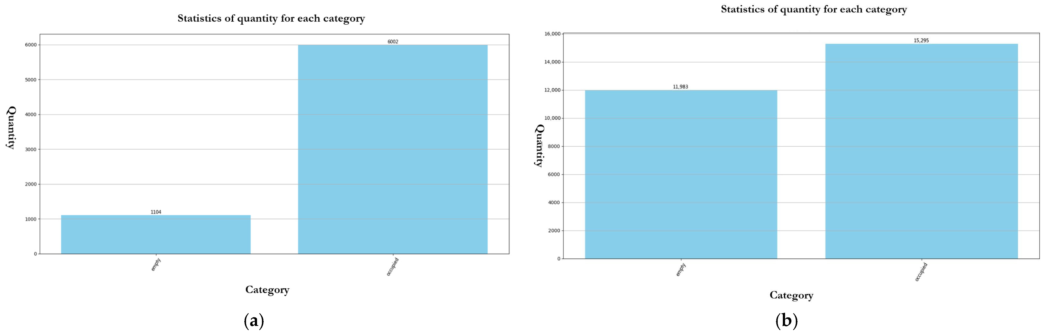
In order to reduce the difference between empty parking spaces and filled parking spaces, in addition to improving the architecture, the data rebalancing method is also used. The original dataset is very unbalanced: there are 1104 empty seat images and 6002 occupied slot instances, with a ratio of approximately 1:5.4. This imbalance may make the model beneficial to the most common classes, but it is not very good at correctly identifying vacancies.
To address this issue, we apply additional augmentation operations specifically to the minority class (empty slots) samples during training:
Random brightness adjustment (±20%, probability 0.5);
Gaussian blur (3 × 3 kernel, probability 0.3);
Random contrast adjustment (±15%, probability 0.4);
Random saturation adjustment (±15%, probability 0.4);
Small-angle rotation (±5°, probability 0.3) with synchronized bounding-box transformation.
After the increase, the effective class ratio during training is balanced to approximately 1:1.3, measured by average instance count per epoch. This balanced distribution improves the resistance of the detector to light changes and small-angle changes, and reduces the category deviation during training.
3.7. Discussion of the Integrated Design
The proposed detector is constructed as a unified system, in which three parts work together, not separately. The “backbone” based on MnasNet effectively generates multi-scale features for small aerial objects; the enhanced EMA module emphasizes directional, local and periodic modes in crowded parking lot environment; the “loss” of UIoU+ transforms these rich features into the “bounding-box” estimation of geometric superiors. The interaction between them is very important for UAV parking space detection, because it needs to balance computing resources, structural uniformity and spatial accuracy. In practice, the “backbone” extracts detailed multi-scale features, the EMA module is optimized to highlight the geometric shape of parking spaces, and the UIoU+ “crack” ensures that these optimized features produce rectangular predictions in an accurate direction.
4. Experiments
4.1. Datasets and Data Rebalancing
To evaluate the performance of the proposed detector in realistic UAV parking scenarios, we created a binary-class parking-slot occupancy dataset with two categories: empty and occupied. There are two main difficulties in this task. First of all, the parking spaces overlooking the sky are often very small, very close to each other and very similar. Then, their appearance is often distorted by the changes in viewing angle, light, shadow and surrounding interference. These characteristics make the dataset very suitable for testing effective feature extraction, context pattern recognition and location-based alignment techniques.
Table 2 shows the main attributes of the dataset used in this survey.
In practical deployment, the system uses a pre-defined Region of Interest (ROI) to restrict detection to the target parking lot only. The ROI can be set either by manual polygon annotation based on the first frame of the UAV video, or automatically by matching the drone’s GPS coordinates with the geofence of the target parking lot. This ensures that the detector only reports parking spaces within the designated area and does not count adjacent parking lots that do not belong to the management scope. This ROI-based boundary control is a standard practice in aerial inspection systems and effectively solves the cross-lot interference problem in real-world applications.
This study uses the self-constructed UAV Parking Lot dataset. It contains 2150 images taken by DJI Mavic 3 and M300 RTK drones, which are flying between 20 m and 50 m. These images come from five different parking areas with different arrangements, such as parallel, vertical and diagonal parking lots. Data collection follows the rules of the parking lot operator, and personal data is deleted from all images. The dataset is divided into 1720 training samples (80%) and 430 verification samples (20%). The input resolution is 640 × 640, and the average target is about 32 × 28 pixels, which proves that it is a challenge for small-target detection. The dataset makes the task more difficult, because the blank and the filled space are very similar, and there are also scale differences, shadow effects and some obstacles.
In order to better understand whether the model can be well summarized, we also tested two known public benchmarks: CARPK [
3] and PKLot [
4]. CARPK dataset has parking photos seen from the sky, with more targets, and they were taken with different camera settings. In contrast, PKLot contains ground parking scenes recorded under different weather conditions. For cross-dataset evaluation, each image is adjusted to 640 × 640, keeping its original aspect ratio and padding. We follow the pre-defined train/test partition of CARPK and PKLot. Together, these datasets provide us with different evaluation scenarios to understand whether the learned functions are applicable outside the original UAV-based domain.
The biggest problem of the first UAV Parking Lot dataset is that there is a great imbalance between categories. Before augmentation, the dataset contained 1104 vacant slots and 6002 occupied slots, yielding a class ratio of about 1:5.4. This imbalance can bias the detector toward the dominant class and reduce sensitivity to vacant slots. To mitigate this issue, class-specific augmentation was applied to the minority class, including random changes in brightness, contrast, and saturation, Gaussian blur, and slight rotation of the target box with corresponding annotation updates. After these modifications, the number of vacant samples increased to 11,983, and the number of occupied samples increased to 15,295, thus reducing the category ratio to about 1:1.3. The total number of tag instances increased from 7106 to 27,278. The class distribution before and after this rebalancing is shown in
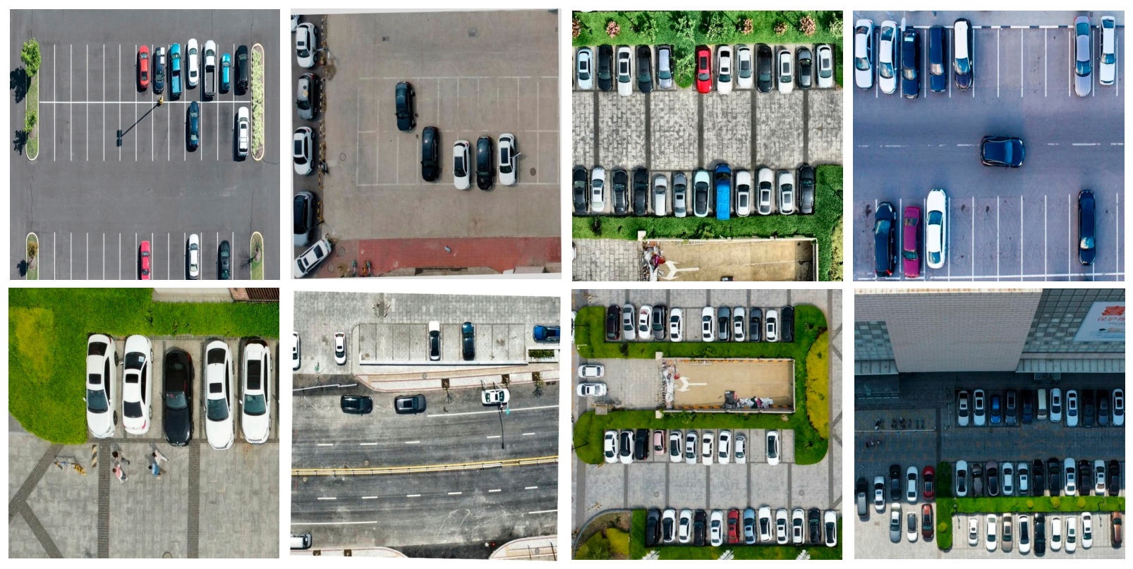
Figure 5, and sample annotations are shown in
Figure 6.
4.2. Experimental Settings
The research was carried out on a workstation equipped with NVIDIA RTX 4090 graphics processing unit and Intel Xeon Gold 5418Y central processing unit. There are also 24 GB of GPU memory and 120 GB of system memory. For the software, we use Python 3.10 and PyTorch framework 2.2.2 [
23]. A summary of this hardware and software configuration can be found in
Table 3.
The proposed method was implemented on top of the Ultralytics YOLOv11 open-source framework (version 8.2.0) to ensure implementation consistency with the baseline. For fair evaluation, all models were tested with the same dataset splits and input resolution of 640 × 640 unless otherwise specified.
Detailed training configurations: We used a batch size of 16 on a single NVIDIA RTX 4090 GPU, with a total of 100 training epochs. The AdamW optimizer was adopted with a weight decay of 1 × 10⁻⁴ and a momentum of 0.937. The initial learning rate was set to 1 × 10⁻³, with a cosine annealing learning rate schedule and a final learning rate of 5 × 10⁻⁴. A warm-up phase of 3 epochs was applied to stabilize early training. Mosaic and mixup augmentations were enabled for the first 90 epochs and disabled for the last 10 epochs to stabilize final convergence. Early stopping was triggered when validation mAP@0.5 did not improve for 15 consecutive epochs, with a patience factor of 0.001.
Inference and post-processing settings: The confidence threshold was set to 0.25, and the NMS IoU threshold was set to 0.45 for all models. All inference results were generated without test-time augmentation (TTA) to ensure fair speed comparison.
Reproducibility settings: All random seeds (Python 3.10, NumPy, PyTorch 2.2.2, and CUDA 11.8) were fixed for each training run, and five independent runs with different seeds were conducted to report mean and standard deviation. Full implementation code, pre-trained weights, dataset annotation specifications, and step-by-step reproduction tutorials are publicly available at the GitHub (
https://github.com/hwqwlsu/UAV_Images-Parking-Slot_Detection) repository specified in the Data Availability section.
Detection performance is measured by precision (P), recall (R), and mean average precision (mAP). The primary metric is mAP@0.5, and the more challenging mAP@0.5:0.95 is also reported as a stricter localization metric reflecting bounding-box quality. To assess practical deployability, we measure model size, parameter count, computational complexity (GFLOPs), and inference speed (FPS) on an NVIDIA Jetson Orin NX device. All quantitative results are reported as the mean ± standard deviation of 5 independent training runs with different random seeds. Statistical significance between the proposed method and the YOLOv11n baseline is verified via paired two-tailed t-tests, with all reported improvements achieving
p < 0.05. These evaluation metrics and complexity indicators are summarized in
Table 4.
4.3. Comparison with State-of-the-Art Lightweight Detectors
We first evaluate the proposed method against mainstream lightweight detectors to verify its overall performance.
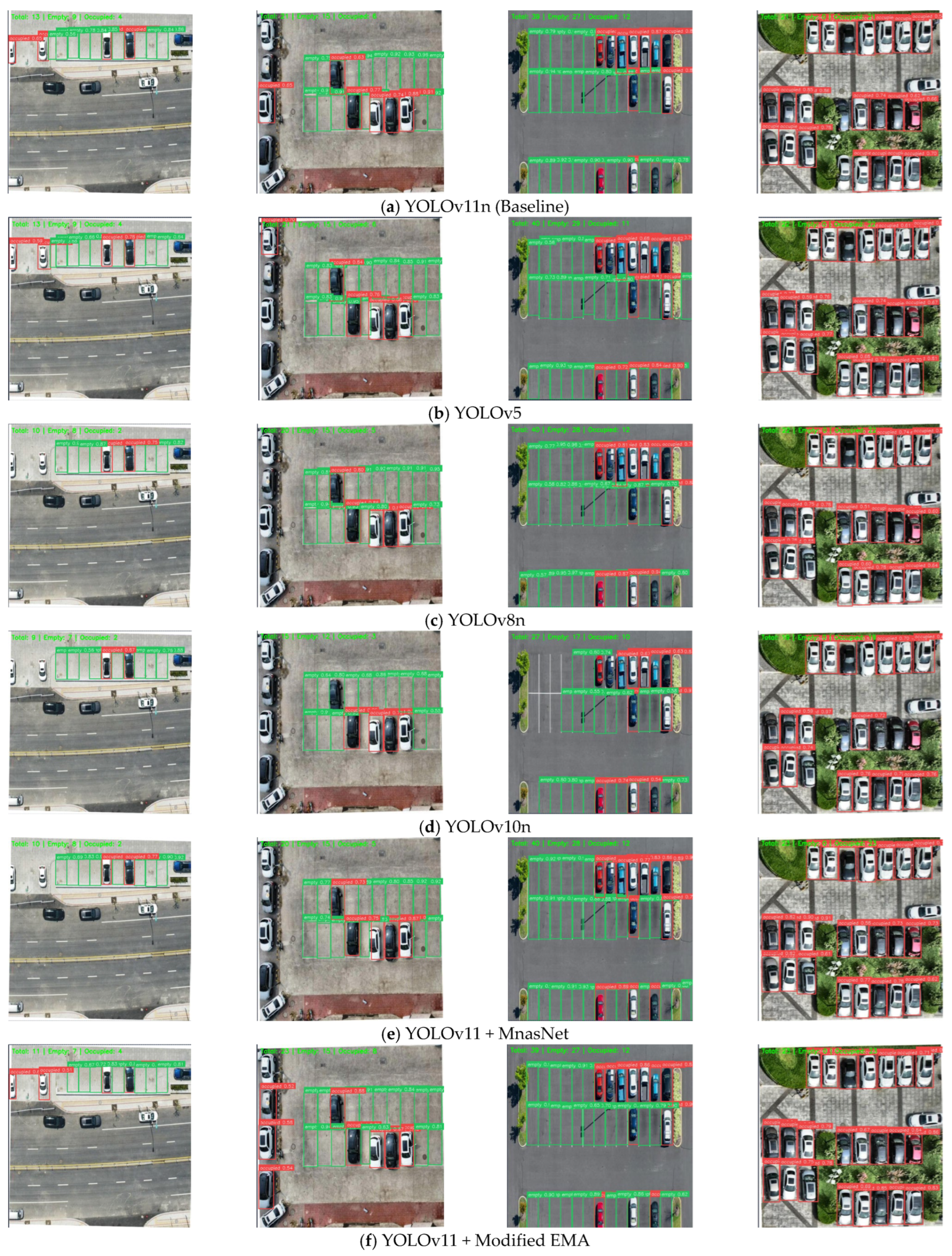
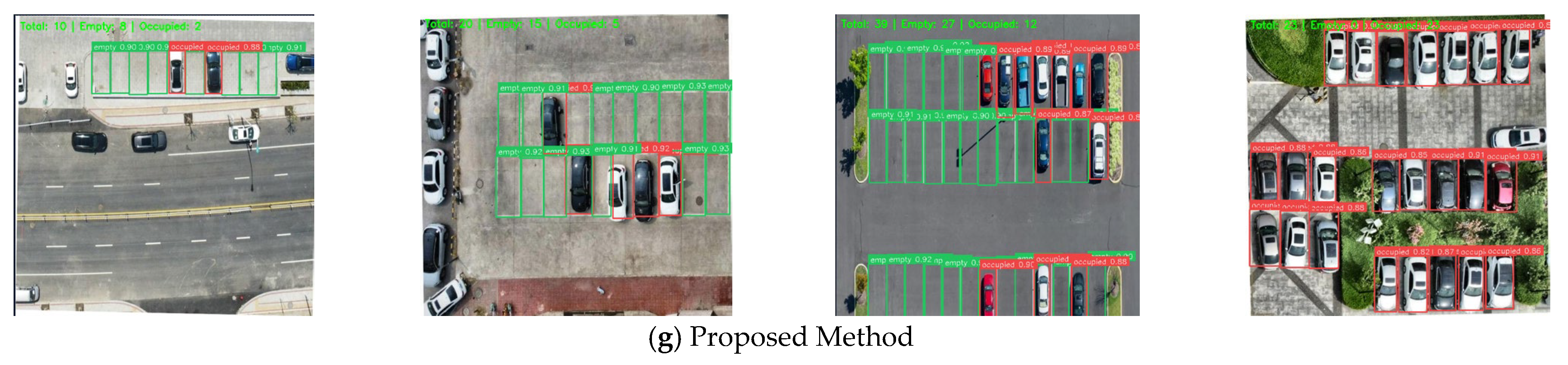
Table 5 presents the quantitative results on the UAV Parking Lot dataset, and
Figure 7 shows qualitative detection examples. To ensure a comprehensive comparison, we include not only classical YOLO variants but also recent state-of-the-art lightweight detectors including YOLOv12n, RT-DETR-tiny, and PP-YOLOE-lite, as well as the specialized Drone-YOLO detector for UAV imagery.
As shown in
Table 5, the proposed method achieves superior performance on the UAV Parking Lot dataset, with 99.44 ± 0.12% mAP@0.5, 99.27 ± 0.15% precision, and 99.00 ± 0.18% recall. The model size is 6.01 MB, with 2.91 M parameters and 6.94 GFLOPs. Compared with the YOLOv11 benchmark, our method improves the mAP by 3.40 percentage points, the accuracy by 4.59 points and the callback by 9.05 points. It only increases the calculation of 0.50 GFLOPs. All improvements are statistically significant (
p < 0.05), The results show that our modification successfully coordinates the accuracy and performance.
By looking at other lightweight models, we can see that our model is better. YOLOv5n is not very good, and it is reduced by 12.55 percentage points in the mAP, which needs more calculation. Our model shows better performance. Compared with the latest YOLOv12n [
12], the proposed method achieves a 2.57 percentage point advantage in mAP@0.5 and a 24.19 percentage point advantage in mAP@0.5:0.95, despite having only a moderately higher computational complexity. Even in the face of a larger YOLOv8n, our detector can maintain better accuracy and reduce complexity. Most importantly, our method exceeds the special model Drone-YOLO [
2] for UAV detection, with an increase of 6.19 percentage points on mAP@0.5 and 32.49 percentage points on mAP@0.5:0.95. All models were evaluated under identical experimental conditions: 640 × 640 input resolution, 100 training epochs, and the same data augmentation pipeline. These results demonstrate that the performance gain comes not from a larger model, but from the integration of more efficient and task-appropriate architectural components.
Notably, the gain in mAP@0.5:0.95 is consistently much larger than that in mAP@0.5 across all three datasets, reaching 26.01 pp on the UAV Parking Lot dataset, 16.84 pp on CARPK, and 19.69 pp on PKLot over the YOLOv11n baseline. This indicates that the proposed UIoU+ loss is more effective in improving localization under stricter IoU thresholds. Compared with conventional IoU-based losses that focus mainly on overlap, UIoU+ further constrains boundary alignment, shape consistency, and aspect ratio, making it more suitable for the geometric properties of parking slots. As a result, it produces more accurate bounding boxes and leads to larger gains in mAP@0.5:0.95. Paired two-tailed t-tests confirm that the improvement is statistically significant (p < 0.01 for mAP@0.5:0.95), rather than being caused by random training variation.
In terms of processing efficiency, our model reaches 52 images per second on NVIDIA Jetson Orin NX device. Although it is slightly lower than the basic model YOLOv11n’s 58 FPS, it far exceeds the 30 FPS benchmark required for real-time deployment on drones. Compared with YOLOv8n and Drone-YOLO, which achieve 43 FPS and 48 FPS respectively, our method demonstrates higher inference speed and superior detection performance.
In summary, our experimental results show that our method provides a better trade-off between precision, recall, and computational efficiency compared with other technologies. This advantage is particularly beneficial for UAV implementations, which operate with limited hardware but require reliable detection performance.
4.4. Ablation Study
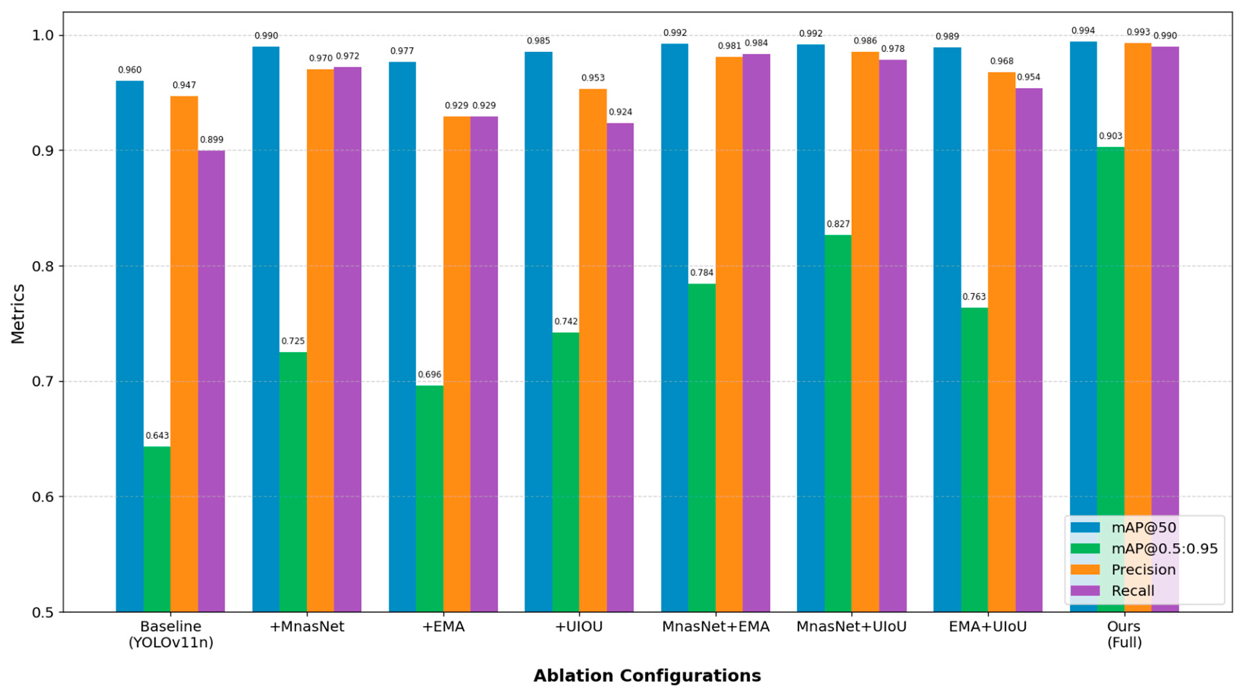
To evaluate the contribution of each component, we conducted ablation analysis on the basic model YOLOv11. We studied three specific changes: replacing the backbone with MnasNet, adding improved EMA mechanism, and using better UIoU+ loss function. Next, we tested different combinations of these functions to see if they can work well together. The results are presented in
Table 6, and performance comparisons are visualized in
Figure 8.
The standard YOLOv11n baseline achieves 96.04 ± 0.40% mAP@0.5, 94.68 ± 0.47% precision, and 89.95 ± 0.50% recall. Replacing the original backbone with our MnasNet-inspired architecture yields the largest single-component performance improvement, increasing mAP@0.5 to 99.00 ± 0.18%, precision to 97.04 ± 0.26%, and recall to 97.19 ± 0.29%. This significant improvement verifies the key role of improved lightweight multi-scale feature representation for UAV parking-slot identification, especially given the small target size and high sensitivity to scale changes.
Compared with the baseline, integrating the refined EMA mechanism as an independent module has also brought great improvement. It improves mAP@0.5 from 96.04% to 97.67%, recall from 89.95% to 92.93%, and the computational complexity from 6.44 GFLOP to 6.45 GFLOP. Although this configuration shows a slight decrease in accuracy compared with the most advanced benchmark, the built-in attention module improves the context perception in dense and crowded scenes, and generates a feature representation of more information for downstream combination with the backbone network and the objective function.
Using only the improved UIoU+ loss improves mAP@0.5 to 98.53 ± 0.31%, precision to 95.30 ± 0.38%, and recall to 92.39 ± 0.41%, without introducing additional parameters or computational overhead. This result confirms that geometry-focused regression is highly beneficial for parking-slot detection, as targets have a strongly rectangular shape and errors typically stem from shape inaccuracies rather than incorrect overlap alone.
When all three elements are used together, the model produces the best results in all measurements, with 99.44% ± 0.12% mAP@0.5, 99.27% ± 0.15% precision and 99.00% ± 0.18% recall. Quantitatively, the combined mAP@0.5:0.95 gain (26.01 pp) exceeds the sum of individual gains (8.20 + 5.30 + 9.90 = 23.40 pp) by 2.61 percentage points, confirming a positive synergistic effect between the three components. The overall improvement is greater than each individual element, which proves that the proposed architecture, attention module and regression function can work well together without duplication. In particular, the complete system greatly improves the recall rate, and also improves and exceeds the accuracy. This shows that this combination method can improve the functional representation, context discrimination and spatial accuracy at the same time.
4.5. Cross-Dataset Generalization
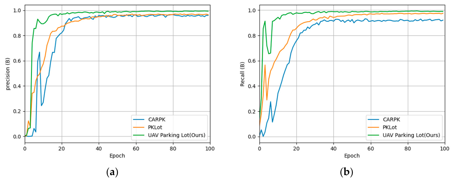
In order to better evaluate how the proposed detection system works in different parking lot settings, cross-datasets are tested, because these settings are usually divided into different areas. The results of this inter-dataset evaluation are described in detail in
Table 7, and corresponding precision–recall curves are shown in
Figure 9.
Even without fine-tuning, our method achieves 97.85 ± 0.21% mAP@0.5 and 76.21 ± 0.33% mAP@0.5:0.95 on CARPK, and 98.12 ± 0.19% mAP@0.5 and 74.58 ± 0.31% mAP@0.5:0.95 on PKLot. Compared with YOLOv11n, our detector shows a gain of 2.48 mAP@0.5 points on CARPK and a gain of 3.23 mAP@0.5 points on PKLot. These results demonstrate that the learned representations generalize well beyond the primary UAV dataset and adapt effectively to different viewpoints, scene densities, and imaging conditions.
The strong adaptability of the model comes from three key design choices: First, the backbone based on MnasNet can minimize the over-learning of dataset-specific textures while maintaining an effective multi-scale representation. Secondly, the enhanced frequency EMA module identifies the overall regularity and periodic patterns of parking teams, and these patterns maintain correlation in different datasets. Thirdly, UIoU+ loss applies geometric constraints that have nothing to do with the appearance of the scene, allowing robust generalization of parking slots with different sizes and configurations.
4.6. Failure Case Analysis and Performance Under Challenging Conditions
To objectively evaluate the limitations of the proposed method, we conducted a quantitative statistical analysis of all failure cases on the UAV Parking Lot test set, and further evaluated performance under typical challenging UAV imaging conditions.
4.6.1. Quantitative Statistics of Failure Modes
We categorized all 43 failure samples in the test set (corresponding to 99.44% overall mAP@0.5) into three dominant failure modes, with detailed proportional statistics:
Severely shadow-obscured slots: Accounting for 53.5% of total failures. When ground markings are obscured by more than 60% due to heavy vehicle shadows or building shadows, the model may produce inaccurate boundary localization or miss the slot entirely, due to insufficient visible edge and contour features. Quantitative tests show that when shadow occlusion ratio exceeds 70%, the detection recall drops to 82.3%, which is the main source of detection errors.
Irregular corner slots: Accounting for 27.9% of total failures. Non-standard corner parking slots with unusual aspect ratios (>3:1 or <1:2) or irregular arc shapes occasionally produce detection errors, as the model is optimized for standard rectangular slot geometry.
Extremely small slots at high altitude: Accounting for 18.6% of total failures. Slots occupying less than 8 × 8 pixels in the 640 × 640 input image (corresponding to flight altitudes above 60 m) are occasionally missed, as the receptive field of the finest detection scale is insufficient to capture their discriminative features.
These limitations are common in UAV-based parking-slot detection and do not arise solely from the proposed method. In practical scenarios, they can be eased to some extent by using better lighting and capturing images from multiple angles. Addressing them more thoroughly will be an important direction for future algorithm development.
4.6.2. Performance Under Challenging Imaging Conditions
To further evaluate the robustness of the proposed method in challenging UAV imaging environments, three difficult test subsets were derived from the original test set, including severe illumination changes, partial occlusion, and motion blur. A comparison with the YOLOv11n baseline is presented as follows.
Illumination changes: Under both overexposed and underexposed settings (±30% brightness variation), the proposed method achieved a mAP@0.5 of 97.82%, exceeding the baseline by 4.15 percentage points. This result indicates that the multi-scale feature representation of the MnasNet backbone contributes to better tolerance to lighting fluctuations.
Partial occlusion: When 20–40% of the parking-slot region was blocked by vehicles or surrounding obstacles, the proposed method reached 95.67% mAP@0.5, surpassing the baseline by 5.72 percentage points. This improvement can be attributed to the enhanced EMA module, which is better able to capture overall structural information and recover discriminative cues from incomplete slot features.
Motion blur: In the presence of mild blur caused by UAV flight instability (simulated using Gaussian blur with a kernel size of 5), the proposed method still obtained 96.91% mAP@0.5, which is 3.89 percentage points higher than that of the baseline.
Overall, the proposed method consistently outperforms the baseline across different challenging conditions, demonstrating its reliability and potential for practical deployment in complex UAV-based parking-slot detection scenarios.
4.7. Efficiency Analysis and Deployment Validation
To evaluate practical performance, a field test was carried out in a 500-space outdoor parking lot under clear daytime conditions, with the UAV flying at 40 m. Using stratified random sampling, 500 samples were selected, including 250 occupied and 250 vacant slots, covering different regions and slot types. During 1 h of continuous operation, the system processed 187,200 frames and achieved an overall field accuracy of 99.0%, correctly identifying 247 occupied slots and 248 vacant slots. Most errors were found in heavily shadowed areas and irregular corner slots.
Finally, we evaluate the computational efficiency of our proposed framework to verify whether the performance improvement is suitable for the deployment with limited resources. A summary of the efficiency indicators is shown in
Table 8.
The proposed method provides a good balance between calculation accuracy and speed. When tested on the UAV parking space dataset, it reaches 99.44%mAP@0.5 and 90.31%mAP@0.5:0.95. In addition, it has a small size of 6.01 MB and can handle 52 FPS on NVIDIA Jetson Orin NX hardware. Compared with heavier architectures such as RT-DETR and D-FINE-N, this model shows higher accuracy with fewer parameters. This combination of high performance and ease of use makes it a very convenient tool.
Although the task is formally binary occupancy detection, the extreme smallness and dense arrangement of targets in UAV imagery make generic lightweight detectors suffer from non-negligible missed detection and boundary deviation. For parking management applications, even a small number of counting errors can directly affect scheduling accuracy and user experience. The proposed architectural improvements are precisely targeted at these unique challenges of UAV scenarios: the MnasNet-inspired backbone strengthens multi-scale small-target feature extraction, the improved EMA module suppresses interference from shadows and background clutter in dense layouts, and the UIoU+ loss improves boundary alignment accuracy for rectangular slots. These improvements collectively ensure high detection and counting accuracy at the edge computing budget of on-board UAV platforms.
The practice in the real world shows that this method is useful. In order to monitor 500 parking spaces from a height of 40 m, the system takes an average of 19.2 milliseconds to analyze images, which is about 52 FPS. It managed to identify 247 slots out of 250 slots and 248 slots out of 250 vacant slots. This makes the overall slot detection accuracy reaches 99.0%, using only 15 W of power. The main detection errors involve hiding the shadow areas of ground markings and corner parking slots with unusual shapes. These results confirm that the detector is well-suited for both laboratory evaluation and embedded intelligent transportation systems requiring real-time operation and energy efficiency.
The experimental results show that our new detection system is very suitable for finding parking areas when used on unmanned aerial vehicles. Compared with the usual lightweight benchmark, our method shows great advantages. This is due to the good improvement of ablation research and the better results of different databases such as CARPK and PKLot in the evaluation framework. In addition, it achieves a favorable balance between computational efficiency and accuracy, demonstrating the practical value of the proposed method.
5. Discussion
The experimental results show us several important things. First of all, performance improvement does not come from a single change. In fact, the three added elements deal with different but complementary parts of the problem. MnasNet-based backbone mainly improves multi-scale lightweight feature learning. The improved EMA component is helpful to better understand the context in dense and orderly environment; UIoU + loss can provide more accurate geometric positioning for rectangular parking slots. Together, these parts provide the most stable and powerful improvement.
Secondly, the proposed technology is still cheap in calculation, although its performance is better. The architecture of the final model only needs 6.94 GFLOPs and 2.91 M parameters, which makes it applicable to UAVs. This is noteworthy, because many improvements in object detection for accuracy greatly increase the computational requirements. The proposed model retains practical deployability while greatly improving detection accuracy.
Third, the data balance method is a very important auxiliary mechanism. By reducing the huge differences between classes, from 1:5.4 to 1:1.3, the training dataset becomes fairer. This may help the final model to have a very good recall rate. This discovery shows that in order to detect parking slots, we need to improve the model architecture and prepare data, rather than just doing these two things in isolation.
Fourthly, the improvement of the frequency domain of the new EMA module is very suitable for identifying the repeated patterns in the parking lot layout. This idea can also be used for other problems that need to perceive the structured environment, such as identifying roads, delineating buildings or monitoring farmland.
In summary, the results show that the proposed method is feasible and can find parking spaces for drones. It is better than the existing lightweight reference model, showing obvious improvement in analyzing its components, and achieving a good balance between calculation efficiency and prediction accuracy.
Regarding the positioning of this work: we do not claim that a highly sophisticated detector is necessary for simple binary occupancy detection under ideal conditions. Instead, we argue that for UAV-based aerial parking inspection with extremely small targets, severe perspective distortion and dense arrangement, targeted model improvements can substantially reduce counting errors and improve system reliability, while maintaining the lightweight requirement for on-board deployment. This is the core motivation of the proposed method.
5.1. Limitations
Despite the encouraging results, several limitations remain. The current evaluation mainly covers daytime scenes, while performance in nighttime or low-visibility conditions still needs validation. The tested UAV altitude is restricted to 20–50 m, so effectiveness at greater heights is uncertain. In addition, the model may be less robust in irregular parking layouts. Broader evaluation under extreme environments, cross-device domain shifts, and continuous video scenarios is also needed. The current system relies on pre-defined ROI to distinguish the target parking lot from adjacent areas; fully automatic parking lot boundary recognition without manual annotation will be studied in future work.
5.2. Comparison with Related Work
Compared with lightweight UAV detectors such as Drone-YOLO [
2], the proposed method has two main advantages: a geometric loss for more accurate rectangular localization and a frequency-enhanced attention module for capturing the regular patterns of parking lot scenes. As a result, it can distinguish occupied and vacant slots more reliably in dense layouts. Relative to general-purpose YOLO variants, it provides higher accuracy with only limited extra computation, which is favorable for UAV-based parking management.
6. Conclusions
This study proposes an efficient and accurate detector for parking-slot occupancy detection using drone images, based on the YOLOv11n architecture. The proposed system combines three elements that work together: a backbone inspired by MnasNet, which is used to extract lightweight multi-scale information of small objects seen from the sky; an enhanced EMA mechanism is used to strengthen important signals in a crowded parking lot environment; and a UIoU+ loss function to better locate the rectangular shape of the parking slot.
Although the results are encouraging, several limitations remain. The current datasets mainly involve daytime scenes, and performance under nighttime and other low-visibility conditions still needs further validation. The tested UAV altitude is also limited to 20–50 m, and effectiveness at higher altitudes has not yet been examined. Future work will expand the dataset, improve robustness in changing environments, optimize the model for resource-limited devices, and extend it to real-time parking monitoring with vehicle-to-slot association. Overall, this work provides a practical basis for UAV-based parking management.