Abstract
This paper presents an ensemble of observed safety margins for aircraft deviations due to convective weather in European airspace. Leveraging historical high-resolution traffic and weather radar data from the FABEC and UK-Ireland FAB regions, meaningful lateral margins are determined based on composite reflectivity and echo top data. These margins enable the estimation of probability distribution for safety distances, supporting both deviation discrimination and lateral separation assessment. Cross-validated results compared against standard binary classifiers and deterministic baseline models indicate that the model effectively distinguishes deviations from non-deviations and accurately estimates lateral margins. This framework enhances understanding of pilot decision-making, contributing to more informed air traffic management and aviation safety strategies.
1. Introduction
In the presence of severe convection, pilots are advised to maintain a safe distance from visible storm clouds [1]. Although jet aircraft are generally allowed to overfly storm clouds if the vertical separation from cloud tops is at least 5000 ft, the safest course of action is a lateral deviation. In storm clouds that develop above 25,000 ft, often characterized by an anvil-shaped top, strong turbulence and dense concentrations of ice crystals are commonly found at higher altitudes. Additionally, aircraft flying at these high altitudes may operate near their performance limit, making them vulnerable to significant updrafts [2].
Regarding the lateral margin that pilots should maintain, the accepted rule is a minimum of 20 NM. This recommendation is particularly important for severe thunderstorms, when hail and turbulence are common in the adjacent regions, more so downwind of the storm core. In less severe storms the safety margin can be lower because the extent of the hazards decreases to about 10 NM [3], albeit never below 5 NM from any visible storm cloud with overhanging areas and therefore never underneath the overhang [4]. Note that this advice is generic, and small differences may exist among companies, who normally follow their own operating procedures [5]. More detailed guidance considering the flight altitude and factors like shape, intensity, intensity gradients, and rate of change is available in [6].
The previous avoidance criteria lack precision without a well-defined reference for measuring distances. Over the years of the space program in the United States (U.S.), extensive research has focused on defining standoff distances for launch commitments during lightning activity. This effort has led to the evaluation of multiple reference points, including the storm centroid, the center of lightning clusters, the nearest discharge location, and the cloud edge (in its conservative radar-based definition of 0 dBZ). Today, the latter two are central to a set of hazard-based criteria [7]. In aviation, however, there is no comparable set of hazard-centered criteria, even though some avoidance guidelines refer to “the area of greatest threat” (e.g., refs. [2,8]). Instead, precipitation-based criteria are often used, primarily due to the lack of sufficient onboard weather information. While most aircraft are equipped with airborne weather radars, not all have access to the latest capabilities or supplementary meteorological data such as lightning detection, ground radar, satellite imagery, or aircraft-derived information. Recent initiatives by the European Cockpit Association (ECA) [9] and the European Union Aviation Safety Agency (EASA) [10] aim to harmonize pilots’ weather information globally and enhance access to the most accurate data available. Meanwhile, the ongoing research into weather phenomena, supported by aviation authorities [11,12], is expected to yield more accurate hazard assessments, paving the way for the development of more sophisticated avoidance guidelines [13]. Such improvements are already visible in next-generation airborne weather radar systems, which incorporate intelligent, hazard-centered capabilities [14,15].
As previously mentioned, the current recommendations for aircraft equipped with an airborne weather radar suggest using precipitation-based contours to measure standoff distances. A common guideline is “avoid all echoes by 20 NM” (e.g., ref. [6]), which may be literally interpreted as maintaining separation from the cloud edge. In relevant literature, isolines (or isosurfaces) at 18 dBZ in two-dimensional (or three-dimensional) radar displays have been used as a proxy for the cloud edge [16]. This reflectivity value is a legacy from the minimum detectable reflectivity of obsolete surface-based weather radars in the U.S. [7]. Similarly, airborne weather radar systems, such as Collins’ MultiScan radar and Honeywell’s IntuVue radar, use a threshold around 20 dBZ to differentiate between no precipitation (black) and light precipitation (green) [17]. However, relying on such thresholds to characterize pilots’ behavior is impractical, as it can result in misleadingly short separations, especially in green-shaded areas and in multi-contoured regions with low-intensity gradients. Moreover, when defining no-fly zones (typically displayed in red), the lower threshold is set at 40 dBZ [1]. A more effective approach to measuring standoff distances would focus on a reflectivity contour that indicates a real threat (e.g., 40 dBZ). Although using a single variable like reflectivity, without accounting for other critical factors (such as cell size, shape, maximum intensity, horizontal and vertical intensity gradients, and rate of change) may not provide an optimal solution, selecting a threshold that reflects a true hazard offers a more practical and reliable basis for determining standoff distances.
While the knowledge of formal recommendations is essential, pilots’ actual behavior when encountering storms is equally critical for tasks like aircraft trajectory planning (e.g., ref. [18]), trajectory prediction (e.g., ref. [19]), and capacity impact assessment (e.g., ref. [20]), enabling safer and more efficient operations for both airlines and air navigation service providers. However, these tasks are often based on generalized guidelines or studies primarily conducted in the U.S., which may limit their effectiveness in other regions. One example is Europe, where air traffic patterns [21], air traffic management systems [22], and convective weather activity [23,24] exhibit different characteristics. Additionally, understanding this behavior is particularly valuable in light of potential climate change, which may increase the frequency and intensity of convective storms across different European regions [25], and of anticipated traffic growth [26].
In this paper, we analyze the actual lateral margins maintained during storm avoidance maneuvers in European en route airspace, which supports the development of a probabilistic model for safety margins based on historical data. The paper has the following structure. Section 2 provides a brief overview of weather radar principles and the relevant literature on characterization of aircraft lateral deviations. Section 3 details the methodology for identifying weather-related scenarios, calculating the lateral margins maintained by aircraft in historical cases, and developing an ensemble-based model of safety distances. These methods are then applied to a case study defined in Section 4. Section 5 presents the results along with a discussion on model performance. Finally, Section 6 summarizes the key contributions of this work and outlines directions for future research.
2. Background
2.1. Basic Weather Radar Principles and General Characteristics
Weather radar is a specialized radar technology designed to detect precipitation, measure its intensity, and with the advent of Doppler radar, track its motion. The radar antenna emits electromagnetic pulses that scatter upon encountering precipitation in the atmosphere. A portion of this scattered signal is reflected back toward the radar, where it is processed to determine the precipitation’s direction, distance, and velocity.
The power returned to the radar receiver, termed reflectivity and measured in decibels of reflectivity (dBZ), depends on the size, concentration, and composition of droplets. Higher reflectivity values indicate larger or more numerous droplets, as seen in thunderstorms, where both droplet size and water content are elevated. Reflectivity also varies based on the type of precipitation encountered. Since stronger returns are observed with higher water content, returns weaken as pulses interact with ground clutter, wet hail, rain, wet snow, dry hail, dry snow, and drizzle. Consequently, convective cells exhibit a particular vertical reflectivity profile, where reflectivity increases from the surface up to just above the freezing level, followed by a sharp decrease [8] (see diagram in Figure 1).
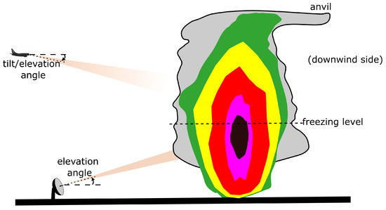
Figure 1.
Diagram illustrating ground-based and airborne weather radars, a storm cell, and its vertical reflectivity profile.
The echo intensity is therefore influenced by the tilt angle of the radar antenna. Modern radar systems, both ground-based and airborne, are capable of scanning weather targets at various elevations. For airborne weather radar systems, effective tilt management is crucial due to factors such as flight altitude, aircraft attitude, decision-making time constraints, and terrain. Although not all systems are equipped with advanced features, many modern systems often include an auto-tilt function that automatically determines the optimal angle. Fully automatic radar systems go a step further, incorporating an auto-scanning function that continuously scans airspace with multiple beams. As of July 2024, automatic radars are available for all A350s and A380s and for 75% of all A320s [27].
For effective decision-making, the horizontal range of meteorological radars is a critical factor. Ground-based radar networks, such as OPERA in Europe [28] or NEXRAD in the U.S. [29], offer extensive coverage that supports monitoring on national or continental scales. These systems provide valuable strategic insights, aiding in long-range planning and weather awareness. However, for tactical air navigation, the data can become outdated due to the time required for data acquisition, processing, and transmission to the aircraft [30]. This latency can result in pilots misjudging the real-time location and severity of weather phenomena, potentially leading to hazardous situations. A striking example occurred in 2023 when a flight departing Milan was caught in a rapidly intensifying hailstorm shortly after takeoff, sustaining severe damage [31]. This risk emphasizes the importance of airborne weather radar systems, which deliver near real-time information and, if properly managed, can be used for both tactical (typically within a range of 80 NM) and strategic (typically within a range of 160 NM) decision-making. On the downside, onboard weather devices have inherent limitations. For instance, their range is shorter and directionally constrained due to aircraft heading, their information cannot be used by ground systems, and they are susceptible to “shadowing” effects, where signals are blocked by intense precipitation or mountainous terrain, leaving blind spots in the coverage [8]. Nevertheless, the processing of radar data remains an evolving field, with continuous advancements aimed at improving accuracy and reducing ambiguity. The ongoing research (e.g., ref. [32]) explores new methods to enhance signal interpretation, which could lead to more reliable meteorological radar data and better support for aviation decision-making.
Given the reflectivity assigned to each three-dimensional pixel within a defined airspace, various 2-D radar products can be derived. Among the most commonly used products are base reflectivity and composite reflectivity. Base reflectivity represents radar returns from the lowest scan angle, providing information about precipitation near the surface. Composite reflectivity, on the other hand, indicates the strongest radar return in a vertical column of pixels, capturing the most intense echoes regardless of altitude. Additional radar-derived products include echo tops, which estimate the maximum altitude of water content within a vertical column by some reflectivity threshold (e.g., 18 dBZ), and vertically-integrated liquid (VIL). VIL provides an estimate of the liquid water content in clouds at a specific horizontal location by integrating reflectivity values over the corresponding vertical column of pixels [33]. This non-linear function correlates with both the intensity of the radar echoes and the vertical extent of the storm. Consequently, VIL offers a more comprehensive depiction of weather conditions (such as strength, maturity, and turbulence) than base reflectivity [34] and composite reflectivity [35]. However, VIL values (measured in kg/) are not as intuitively interpretable as reflectivity values, which are commonly expressed in distinct levels associated with specific colors [36]. To make VIL data more accessible to the aviation community, they are often conveyed using the six-level video integrator and processor (VIP) scale [37], as summarized in Table 1.

Table 1.
VIP levels and their associated radar reflectivity ranges.
2.2. Related Works on Characterizing Lateral Deviations due to Convective Weather
Several studies in the literature have attempted to characterize pilots’ lateral deviations when navigating through convective weather, though the findings are often not detailed. Survey results indicate that commercial pilots maintain a minimum separation from the “outer green edge” (indicating light precipitation) ranging from 10 NM to 50 NM [38]. However, these margins appear to align more with official guidelines than actual in-flight practices. Other studies suggest that pilots typically maintain lateral buffers of approximately 5 [39] to 7 NM [40] from 40-dBZ reflectivity polygons.
Additionally, there are analyses of actual margins between flight trajectories and precipitation cells observed during historical storm days in the U.S. DeLaura and Evans [41] identify a set of 218 situations of interest dating from 2003, determine one characteristic cross-section per situation, and calculate the margins maintained by deviating aircraft with respect to isolines at different VIL levels, concluding that those margins for VIL level 2 and 3 are the most consistent. More precisely, the 75th percentiles of the resulting margins are 10.8 NM and 13.5 NM for VIL level 2 and 3, respectively. Kuhn [42] also uses VIL levels as a reference but adopts a storm-centric approach rather than a flight-centric one. After collecting a larger dataset comprising 40 storm days from 2007 and dividing the airspace into cells, the researcher identifies those cells with VIL levels of 4 or higher and echo tops at or exceeding 35,000 ft, labeling them as storms. The occupancy of each grid cell is then evaluated, revealing that aircraft generally avoid flying within 3 NM of the storm cells, with deviations extending up to approximately 10 NM.
The previous research has provided valuable insights, including the identification of consistent VIL levels for standoff-distance measurements and documentation of historical lateral margins. However, their approaches have certain limitations.
First, relying on VIL levels may not be ideal. While the aforementioned authors have used VIL based on analyses identifying weather features most relevant to pilot decision-making [41], operational users (including researchers [19,43]) often apply lateral margins based on reflectivity levels. Moreover, converting VIL into VIP levels (see Table 1) entails certain assumptions that are sometimes overlooked. Specifically, this conversion relies on a linear regression between VIL and radar reflectivity, adjusted by Troxel and Engholm with historical storm data from the U.S. [44]. However, convective storms in Europe generally exhibit weaker reflectivity structures [23,24] compared to their U.S. counterparts. This discrepancy suggests that applying the same regression in Europe may lead to less accurate assessments of storm intensity. In addition, the reflectivity thresholds for VIP levels, initially derived from legacy rainfall-based divisions [45], have become somewhat outdated with advances in radar technology [46,47]. Modern radar standards have been refined (see Table 1) and offer more consistency between ground-based and airborne weather radar systems, particularly in the U.S. [36]. In Europe, weather data are often not tailored specifically for aviation [10], and the situation is more fragmented [48]. Ground-based radar systems, and their associated reflectivity coding schemes, vary across different countries, resulting in less uniform radar data presentation [49]. Therefore, the widespread application of imported VIL levels for standoff-distance measurements within the current European context is deterred even further.
A second limitation appears when selecting the cells from which margins are determined. In DeLaura and Evans’s work, each margin in a weather-related deviation is calculated from a single cross-section, drawn by a first analyst and corroborated by a second analyst. However, this method does not consider separation from other storm cells being avoided during the same maneuver, and, as the authors acknowledge, it involves a degree of subjectivity. In contrast, Kuhn’s strategy accounts for multiple separations during the same maneuver and seems more objective and reproducible. The main drawback is the consideration of storm area as those pixels with VIL levels of 4 or higher and echo tops at or above 35,000 ft, which may exclude many weather-related deviations from less severe convective cells.
The relevant literature offers other methods for defining the three-dimensional weather hazards that can be used when measuring lateral margins for aviation and meteorology applications. Tafferner et al. [50] suggest creating “thunderstorm objects”, formed by bottom volumes and top volumes. The bottom volumes are defined by using three-dimensional radar data and lightning data. They reach the echo top height and are divided into two severity levels, 33 dBZ and 41 dBZ. For the top volumes, with a vertical thickness of 3 km, satellite data and a lightning-density criterion are used to determine the horizontal boundary. The upper limit is made coincident with the tropopause level. Although this construction accounts for the different hazards existing in the vicinity of the thunderstorm, it appears too complex for the purpose of this paper, with too many data sources involved. A more streamlined approach is proposed by Lewis et al. [39]. From base reflectivity data, areas with at least 40 dBZ are determined, while from echo top data, areas with a minimum altitude varying from 25,000 ft to 50,000 ft in 5000-ft steps are determined. All these contours are subsequently substituted by their convex hulls. Next, to build the vertical structure, each 40-dBZ convex polygon is intersected with all the convex polygons defined by the lowest echo top threshold. If the intersection is null, the corresponding reflectivity polygon is filtered out, but if any intersection exists, the reflectivity polygon is accepted in its entirety, with the floor at the ground level and the ceiling at the current echo top threshold. To better characterize the ceiling of these volumes, the process continues with the rest of the echo top thresholds in ascending order. While this approach is conservative and simplified, it can be computationally demanding, especially when the radar data are rapidly refreshed. A faster alternative is the Traffic Convective Forecast product in the U.S. [51], which defines convective zones based on three criteria with a minimum forecaster confidence, namely: a composite reflectivity of at least 40 dBZ, echo tops of at least 25,000 ft, and an overlap of 25% or more between the reflectivity and echo top areas.
Additional criteria have been proposed for determining relevant convective cells. For example, minimum cell size thresholds include 8 k to capture developing cells [52], 20 k to discard minor areas [39], and 520 k for severe convection at a continental level (reducible to 50 k at the sector level [53]). Dixon and Wiener [54] propose a 50 k volume threshold to filter out noise and small ground clutter while limiting storm detections. In other cases, the focus is on excluding stratiform precipitation areas by setting thresholds that target strong convective activity. For instance, Martín [55] suggests applying a gradient threshold designed to detect strong updrafts and downdrafts (specifically, a threshold of 40 dBZ as a local maximum within a radius of 11 km) and a reflectivity threshold of 45 dBZ inside the 40 dBZ contour.
In a flight-centric approach like the one employed by DeLaura and Evans, a paramount step is the identification of the en route weather-related deviations. In [41], the process is as follows. First, only flights meeting specific conditions are retained; they must spend at least 15 minutes at or above 25,000 ft, and experience a “weather encounter”. A weather encounter is defined as any instance where the planned trajectory (with timestamps adjusted based on actual groundspeeds) intersects an area with VIL level 2 or higher, or echo tops at or above 25,000 ft, for at least two minutes. Next, from the flights identified, those with an average deviation in the weather-affected portion of their planned trajectory that exceeds a predefined threshold are classified as exhibiting a weather-related deviation. According to the authors, this deviation detection algorithm constrains data processing capacity due to the need for human supervision. Consequently, an upgraded version was later proposed to address this limitation. In Matthews and DeLaura’s version [56], the detection of deviations is uncoupled from the detection of weather encounters. To find deviations, a flight separation from its flight plan must exceed a predefined threshold for at least one minute. Whenever a deviation is flagged, the beginning and the end of the deviation are identified. Once all the deviations and weather encounters have been detected for a given flight, they are spatially merged one-by-one looking for weather-related deviations. According to the authors, this algorithm significantly outperforms the previous version, reducing the classification error from approximately one-third to less than one-tenth.
An alternative approach is presented by Olive and Basora [57], who propose a framework for detecting anomalies in air traffic data, including deviations caused by thunderstorms. Using autoencoding artificial neural networks applied to trajectory flows across varied scenarios, the authors observe that the highest reconstruction errors correspond to adverse weather conditions. This finding suggests that deviations caused by thunderstorms can be effectively captured. Similarly, Dalmau and Gawinowski [58,59] introduce a supervised framework for predicting and characterizing weather-related flight diversions. The 2023 study employs machine learning with confident learning to detect weather-related diversions while filtering out non-weather-related cases. The 2024 study builds on this approach by incorporating supervised clustering, which improves the characterization of different types of weather-induced diversions, providing a more refined understanding of their causes.
Lastly, neither DeLaura and Evans nor Kuhn provide a comprehensive description of the actual distributions of lateral margins. Given the wide range of factors for hazard evaluation, factors for decision-making, and modulating factors [38], a probabilistic approach seems appropriate for managing the inherent uncertainty.
3. Methodology
In this paper, we adopt a flight-centric approach to compute lateral margins in historical storm scenarios and develop a probabilistic model of safety margins. The process begins with the identification of weather-related deviations, following the general algorithm described in [56]. Section 3.1 briefly summarizes the main steps of this algorithm, highlighting our specific parameter choices and subroutine modifications. Once the situations of interest are identified, we compute the historical lateral margins between convective cells and both planned and actual trajectories. Section 3.2 outlines the criteria for defining convective cells in our problem, selecting those relevant to each maneuver and calculating the lateral margins with respect to multiple cells using frequently updated weather radar data. Section 3.3 presents our probabilistic model of safety margins, while Section 3.4 details the methodology for evaluating the model’s performance.
3.1. Detection of Weather-Related Deviations
The methodology for detecting weather-related deviations, summarized in Figure 2, starts by identifying weather encounters in historical traffic data. In this paper, a weather encounter is defined as any instance where the planned trajectory intersects an area with VIL level 2 or higher, or echo tops at or above 24,500 ft (a representative value in the European airspace structure), for at least two minutes. Planned trajectories are adjusted for actual take-off time or the earliest available timestamp when departure time is unavailable. Hereafter, regions meeting these meteorological criteria are referred to as weather areas.
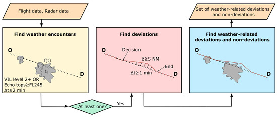
Figure 2.
Summary of the algorithm for detecting weather-related deviations and non-deviations, inspired by [56].
From a practical perspective, verifying whether these conditions are met requires addressing two main challenges. First, weather radar data are frequently updated, and therefore intersections must be carefully handled. Our strategy is as follows:
- For each time interval with a meteorological picture, extract the polygons of the weather areas, label them, and trim the flight trajectories for the interval.
- Compute the intersections between the trimmed trajectories and labeled polygons, determining entry and exit points and times.
- Repeat the process for every time interval of interest.
- Organize the results so that the sequence of encounters for each flight can be analyzed.
- For each flight, merge consecutive periods within a polygon, which correspond to weather updates.
- Check whether closely spaced encounters for each flight can be merged, using a threshold of one minute.
- Discard weather encounters lasting less than two minutes.
Second, radar data are typically provided in a pixel-based structure, requiring careful extraction of polygons to represent weather conditions accurately. For example, if an isolated pixel meets the specified conditions, the resulting polygon is a quadrilateral rather than a single point. To manipulate all geometric objects in this study, the Python package shapely 2.0.1 [60] has been used.
Next, flights with at least one weather encounter are further filtered to retain only those exhibiting a lateral separation of 5 NM or more from their planned trajectory for at least one minute. To prevent misclassifications, all holding patterns are removed beforehand. When a deviation is flagged, the beginning and end of the maneuver are determined based on distance and time thresholds, as detailed in [56].
After identifying all deviations and weather encounters for a given flight, they are spatially paired looking for weather-related deviations and non-deviations. This algorithm serves as a filter to confidently detect situations of interest, referred to as scenarios hereafter. Note that some weather-related deviations may not be captured, for instance, when a flight deviates due to adverse weather without encountering it along its planned path. However, these cases are presumed to be rare due to the lenient conditions applied.
3.2. Calculation of Lateral Margins
We need to calculate the lateral margins maintained in the historical scenarios identified in Section 3.1. These margins, defined as the minimum distance between a flight trajectory and the relevant convective cells observed from the decision point to the end of the maneuver, can be computed for both planned and actual trajectories. Their respective measurements are denoted by x and y and are referred to as initial and final lateral margins, respectively.
To calculate the lateral margins, a reference for the convective cells must first be established. This reference is defined as composite reflectivity contours of 40 dBZ, with echo tops reaching or exceeding 24,500 ft at some point within the cell. This definition balances several considerations: practicality given current radar capabilities and current airborne-radar color coding standards, significance of vertical extent, simplicity, and consistency with the literature reviewed in Section 1 through Section 2.2. Despite the generally weaker convective structures in Europe, these thresholds are not overly restrictive. This is supported by [61], which uses 40 dBZ as a continental standard for identifying convective activity, and [24], which compares typical echo top values across several European countries. The results obtained using this definition will be supplemented with a sensitivity analysis. This analysis will explore variations in the reflectivity and echo top thresholds, as well as incorporating additional criteria, such as a minimum cell size to exclude minor areas from an operational perspective, and a lower bound for the maximum reflectivity within the cell to filter out stratiform precipitation.
In general, the previous definition holds for cells inside and outside the areas causing the weather encounter (i.e., VIL level 2 or higher, or echo tops at or above 24,500 ft, for at least two minutes). Since aircraft may avoid multiple threats when maneuvering, it is important not to limit the scope to just the cell triggering the deviation. However, it remains crucial to restrict the calculation to the relevant cells. By enforcing this approach, the resulting margins will be meaningful and the computational cost will remain manageable.
We have developed a method to select relevant cells, consisting of four steps, as shown in Figure 3:
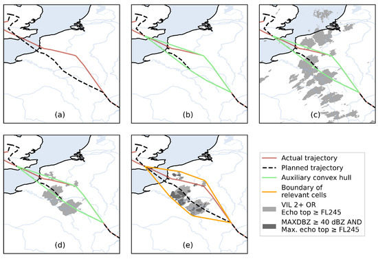
Figure 3.
Identification of relevant cells for a historical weather-related flight deviation (Ectrl ID: 255062315): (a) actual trajectory and flight plan; (b) auxiliary convex hull encompassing potential avoided areas; (c) all weather areas within the maximum time interval from decision point to maneuver completion; (d) intersecting weather areas filtered for relevance; and (e) final boundary of relevant cells, along with all potential cells used for distance measurements.
- Compute the convex hull that encompasses all points in both the actual and planned trajectory from the decision point to the end point.
- Determine the maximum time interval for the weather data, defined by the period from the earliest decision point (either actual or planned) to the latest end point (either actual or planned).
- Identify all weather areas during the period determined in Step 2, and intersect with the convex polygon determined in Step 1.
- Compute a new convex hull that encompasses both the initial convex polygon and all the weather areas identified in Step 3.
The resulting convex hull will define the boundary of the relevant reflectivity contours. Note that this convex hull is applicable to both deviation and non-deviation scenarios, as well as to the calculation of lateral margins for both actual trajectories and planned trajectories, and can account for threats on either side of the aircraft.
For each scenario (whether a deviation or non-deviation scenario), two margin values are obtained: one for the actual trajectory and another one for the time-adjusted planned trajectory. Our approach for determining the lateral margin accounts for multiple cells and frequently updated weather radar data. For each time period with a fixed meteorological picture, the trajectory is trimmed, retaining only the portion within that period. In any given frame, cells may exist both forward or backward relative to the trimmed trajectory. Since we are focused on lateral margins, a filtering step is applied. This involves intersecting the convective cells with a defined stripe (see Figure 4), constructed through a series of steps described in Appendix A. Only the intersecting cells are considered for calculating distances between the trajectory segment and each valid cell in the current timeframe. Among the calculated distances, the minimum value is retained as long as the flight altitude is above 24,500 ft. This process is repeated for all timeframes from the decision point to the end point. The lateral margin assigned to the scenario is the minimum value observed across all timeframes.
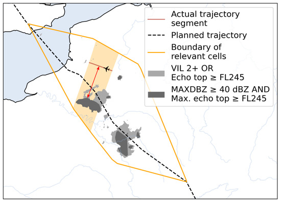
Figure 4.
Illustration of the stripe used to compute the lateral margin of an actual trajectory within a specified timeframe during a historical weather-related deviation (Ectrl ID: 255062315, 17:40–17:45).
Note that in some deviations and non-deviations, convection is not sufficiently intense to meet the defined cell conditions. In such cases, the values of x and y are unavailable.
3.3. Determination of Safety Margins. The Proposed Model
When modeling deviations are based on the loss of separation from existing convective hazards, a reasonable approach for determining final separation is to take the maximum between the initial separation x and the safety margin s, the determination of which is the focus of this research. If the planned flight path provides sufficient separation (), the final lateral margin will be the same as the initial one. Conversely, if the separation is inadequate (), the final lateral margin will be set to s, reflecting the expectation that pilots will adjust the trajectory to reestablish a safe distance. In practice, the existence of multiple cells in the vicinity may impose additional constraints. A specific corner case arises when both x and s are zero. To ensure consistency with the calculation of lateral margins (where a value of 0 includes both tangential passing and crossing), the condition for a loss of separation is . With this definition, when and , the aircraft is assumed to follow the flight plan.
After calculating the lateral margins as explained in Section 3.2, one question remains: determining the value of s. Acknowledging that lateral margins with respect to the nearest relevant convective cell exhibit random behavior (which is partially observed in [41]), it is more appropriate to treat the safety margin as a random variable S. In [43], this uncertainty is modeled through a risk-based framework, where a formally recommended margin (e.g., 20 NM) is scaled by a factor between 0 and 1. Whether the interpretation involves a random safety margin or a random pilot’s risk tolerance, determining the probability distribution for this random variable is crucial.
To determine the probability distribution for S, we consider that lateral margins of both planned and actual trajectories relative to the nearest relevant convective cell exhibit random behavior. Accordingly, initial and final lateral margins are modeled as the random variables X and Y, respectively. In our framework, , and the cumulative distribution function (CDF) of Y can be expressed as
Assuming that X and S are independent, simplifies to the product of their respective CDFs, and . Consequently, can be derived as
This formulation enables us to estimate the distribution of S given the behavior of X and Y. The distribution can be approximated empirically using a sample set of n deviation and non-deviation scenarios. In this approach, and are approximated using their respective empirical CDFs.
Once is determined, we can tackle two key problems: (1) modeling whether a flight deviates based on its initial separation from convective hazards and (2) modeling the final separation distance. To address the first problem, we determine the probability that a flight deviates, , which can be derived from for a specific scenario with initial separation x. Since X and S are assumed independent, . To address the second problem, an optimal ensemble of M quantiles is built:
Thus, the associated ensemble-based model for the final lateral margin in a specific scenario with initial lateral margin x is
3.4. Assessment of the Probabilistic Safety Margins
The evaluation of our one-for-all model is carried out in two steps, each addressing a distinct functionality. First, we assess the classification model, followed by the separation model. For this purpose, we utilize an additional sample set, , consisting of deviation and non-deviation scenarios.
For the evaluation of the classification model, we evaluate the model’s ability to discriminate between deviations and non-deviations. This discrimination is achieved by converting probabilities into deterministic predictions using a predefined probability threshold. A commonly used metric for evaluating overall performance independently of the threshold is the area under the receiver operating characteristic curve (ROC-AUC score), which ranges from 0 to 1, with higher values indicating better performance [62]. The ROC curve plots the true positive rate against the false positive rate, defined as follows:
Notice that a ROC-AUC of 0.5 is equivalent to random guessing.
The performance of our classification model is compared against two standard binary classifiers. The first classifier is Gaussian Naïve Bayes (GNB), which models the probability of deviation as
assuming a normal distribution for . Note that for only one feature, as in our case (with only x), the GNB coincides with other Gaussian Bayes classifiers such as the linear discriminant analysis (LDA). For simplicity’s sake, we call it GNB. The second classifier is logistic regression (LR), which predicts the probability that a flight deviates using the logistic function. Additionally, we evaluate the model’s discrimination skill against a decision rule (DR), which predicts a deviation when for a predefined threshold s.
To evaluate the performance of our separation model, the continuous ranked probability score (CRPS) is computed following [63] for each prediction :
The mean CRPS (MCRPS) across all scenarios serves as the primary metric to evaluate our model’s accuracy. Note that the MCRPS generalizes the mean absolute error used for deterministic forecasts, and therefore, a lower value indicates better performance. This metric is compared against the maximum between x and a fixed safety margin s.
4. Case Study
The previously described methodologies are now applied to a set of historical scenarios across the combined European regions of FABEC and UK-Ireland FAB. In particular, the dataset for this study comprises eight summer days in 2022 characterized by significant convection activity: four in June (5, 21, 28, and 30) and four in September (5, 6, 7, and 14). To evaluate model performance, a leave-pair-out cross-validation procedure [64] is employed, where each iteration reserves the entire data from two case days as the validation subset. With this strategy, we seek a reliable and unbiased estimate of model performance while minimizing the information leakage between training and validation subsets.
4.1. Weather Radar Data
The weather radar product used in this work is the hI-Resolution Mosaics for Aviation (IRMA) [65], which provides high-resolution reflectivity measurements in a regular 3D grid. In particular, it covers our area of interest (see Figure 5) with a horizontal resolution of 1 × 1 k at 24 different vertical levels 500 m apart and has an update cycle of 5 minutes.
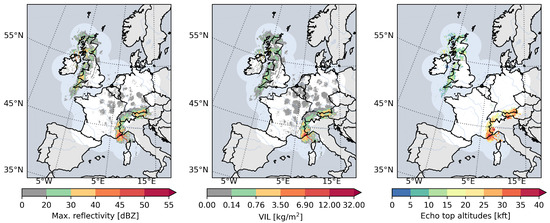
Figure 5.
Snapshots of composite reflectivity, VIL, and echo top (from left to right) on 28 June at 14:40.
Specifically, three distinct radar measurements are utilized: composite reflectivity, VIL, and echo top (18 dBZ). To ensure compatibility with flight altitudes, the echo top heights were adjusted to correspond to pressure altitudes by using geopotential data from the ERA5 reanalysis dataset [66].
4.2. Traffic Data
The historical traffic data have been retrieved from two different sources. The planned flight trajectories are retrieved from Eurocontrol’s R&D Data Archive and correspond to the last filed flight plan, while the actual flight trajectories are downloaded from the historical dataset of Opensky Network [67], with a higher resolution than the trajectories provided by Eurocontrol. The open-source Python package traffic 2.8.1 [68] was utilized to download the actual trajectories.
Due to the presence of erroneous records and missing data in the Opensky flight trajectory dataset, a pre-processing step was required. A doubly conservative approach was adopted: prioritizing removal over correction while preserving as much valid data as possible. Specifically, the following steps were undertaken:
- Point removal: eliminated records affected by on-ground status, NaN values, duplicate entries, or spatiotemporal outliers.
- Unpaired flight legs: detected and removed flight legs that could not be matched with planned trajectories.
- Weather radar coverage: discarded points located outside the radar coverage area.
- Gap identification: identified gaps where the distance between consecutive waypoints exceeded 30 km. Trajectories with such gaps were split, treating each piece of trajectory independently.
- Flight filtering: removed flights or trajectory pieces that did not meet a minimum duration of 15 min or contained at least 30 waypoints.
- Trajectory association: matched each resulting piece of actual trajectory with the closest piece of the corresponding planned trajectory.
Two additional flight filters were applied to refine the flight dataset. First, only those non-military aircraft heavier than 7000 kg were retained, corresponding to the M, H, and J categories under the ICAO wake turbulence classification [69]. Second, flights with atypical callsigns were discarded.
The resulting flight dataset consisted of 149,158 flights (or flight segments) distributed as follows by date: 12.4% on 5 June, 12.7% on 21 June, 12.8% on 28 June, 13.1% on 30 June, 12.5% on 5 September, 12.5% on 6 September, 12.9% on 7 September, and 11.1% on 14 September.
5. Results
The application of the algorithm for detecting weather-related deviations identifies a total of 16,291 relevant scenarios. The distribution of deviations and non-deviations by date is presented in Table 2.
Table 2.
Overview of weather-related deviations and non-deviations, grouped by date.
For each relevant scenario, the initial and final lateral margins are computed, with the results detailed in Section 5.1. Building on these margins, our model is developed and evaluated, as described in Section 5.2 and Section 5.3.
5.1. Analysis of Historical Lateral Margins
The lateral margins, grouped by date and data type, are gathered in Figure 6, with separate presentations for deviation and non-deviation scenarios. Given our selected reflectivity and echo top thresholds, 16.1% of scenarios lack contours, resulting in no available margins.
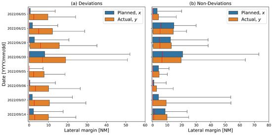
Figure 6.
Summary of lateral margins (5th to 95th percentiles) for each case day, categorized by scenarios of (a) deviations and (b) non-deviations, using both planned and actual flight data.
The analysis of lateral margins during flight deviations (Figure 6a) reveals several key observations. For planned flight data, the median values are all zero, but the degree of dispersion (e.g., the range between the 5th and 95th percentiles) varies notably: 5 September exhibits the least dispersion, whereas 30 June shows the most. Turning to actual flight data, the median lateral margins range from 2.3 NM (on 5 September) to 6.9 NM (on 30 June), with an overall median of 3.7 NM. Furthermore, 79% of all deviating aircraft maintained a separation distance within 13.5 NM (25 km), consistent with the finding for VIL level 3 reported in [41]. In general, as expected, final separation distances tend to increase compared to initial separations, with a corresponding increase in variability.
Lateral margins for aircraft adhering to their planned routes (Figure 6b) also show noticeable differences across dates, although the variations between planned and actual flight data are minimal. The median final lateral margins range from 0 NM (on 5 June, and 5–7 September ) to 6.4 NM (on 30 June) with an overall median of 1.0 NM. Half of the dates exhibit significant dispersion, with the highest variability observed on 30 June and 7 September.
An important commonality between deviation and non-deviation scenarios across dates and using both planned and actual flight data is that their asymmetric distributions exhibit a peak at zero lateral margin. The presence of this peak at zero suggests that a significant proportion of aircraft were observed in close proximity to convective cells. From a statistical perspective, this could resemble a zero-inflated distribution, where an excess of observations at zero indicates a different underlying process compared to the rest of the data. Zero-inflated models are often used when a dataset contains more zero values than expected under a standard probability distribution [70], which could be relevant in this context. However, physically, this peak can be attributed to multiple operational and meteorological factors: aircraft may have overflown the closest cell, the ground-radar images might have become outdated within the 5-minute interval, or the weather conditions in the closest cells were not severe enough. To better discriminate between deviations and non-deviations, it is crucial to filter out non-relevant cells. To that end, various combinations of reflectivity and echo top thresholds are tested: 45 dBZ and 24,500 ft (denoted by MAXDBZ45_TOP245), 50 dBZ and 24,500 ft (MAXDBZ50_TOP245), 40 dBZ and 30,000 ft (MAXDBZ40_TOP300), and 40 dBZ and 35,000 ft (MAXDBZ40_TOP350). Additional criteria are also explored, including a minimum cell size of 20 k [39] (MAXDBZ40_TOP245_20km2) and a minimum intensity of 45 dBZ within the cell [55] (MAXDBZ40_TOP245_45dBZ). The resulting distributions are presented in Figure 7.
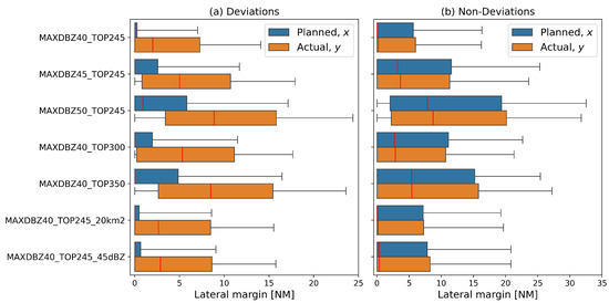
Figure 7.
Summary of lateral margins (5th to 95th percentiles) for each cell definition, categorized by scenarios of (a) deviations and (b) non-deviations, using both planned and actual flight data.
As expected, increasing the severity of reflectivity, echo top, and additional criteria leads to greater overall median and dispersion for both deviations and non-deviations, while still remaining within the tactical decision-making range. In particular, this increase can be significant enough to shift the median initial separation away from zero, occurring with MAXDBZ50_TOP245 for deviations and across all new definitions for non-deviations. On the downside, more stringent criteria also reduce the number of available margins. Specifically, the percentage of unavailable margins is 24.4% for MAXDBZ45_TOP245, 31.9% for MAXDBZ50_TOP245, 25.6% for MAXDBZ40_TOP300, 31.8% for MAXDBZ40_TOP350, 18.2% for MAXDBZ40_TOP245_20km2, and 19.3% for MAXDBZ40_TOP245_45dBZ. We will retain all cell definitions in the assessments to identify which yields the best performance.
5.2. Assessment of Decision-Making Predictions
Using the margins calculated in Section 5.1 for MAXDBZ40_TOP245, the cumulative probabilities are computed for each iteration of the cross-validation exercise. The resulting curves, shown in Figure 8, reveal that most of the variability is within the 0 to 40 NM range. The corresponding probabilities of deviation for each initial lateral margin are derived and presented in the same figure, decreasing with increasing lateral margins (the probability of non-deviation shows the complementary trend). At zero, shows an average value of 0.5069, and consequently, the probability of deviation, calculated as Pr, is on average 0.4931.
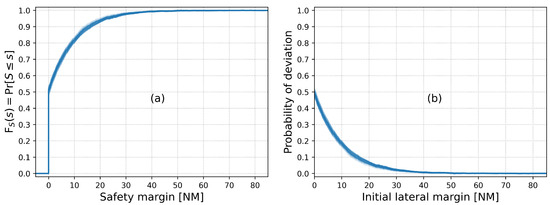
Figure 8.
(a) Cumulative distribution function and (b) estimated probabilities of deviation for each cross-validation iteration.
Using these probabilities of deviation, we assess our model’s performance. Although scenarios without a lateral margin cannot contribute to model development, they are used for testing, as pilots’ decisions are known. If a value is unavailable, we always predict a non-deviation.
We evaluate our model’s ability to discriminate between deviations and non-deviations, with the ROC-AUC results summarized at the top of Figure 9. Across cross-validation iterations, the performance ranges from 0.6319 to 0.7305, with an average of 0.6796. These values indicate a moderate discrimination, outperforming random guessing (0.5). When compared to the ROC-AUC of the GNB, LR, and the decision-rule model specified in Section 3.3, none of these models achieve significantly better performance. While our model outperforms GNB, its ranking relative to LR and DR remains unclear. To statistically check for differences between our model and LR and DR, we conducted two separate Wilcoxon signed-rank tests [71]. The null hypothesis in each test is that the median difference over the 28 cross-validation iterations is zero. The resulting p-values [72] in the comparisons against LR and DR are 0.27 and 0.11, respectively. Given these values, we cannot reject the null hypotheses at an alpha level of 0.05, which means our model’s performance is statistically comparable to that of the LR and DR. This suggests that the classification task itself is inherently challenging, rather than being a limitation of any specific model.
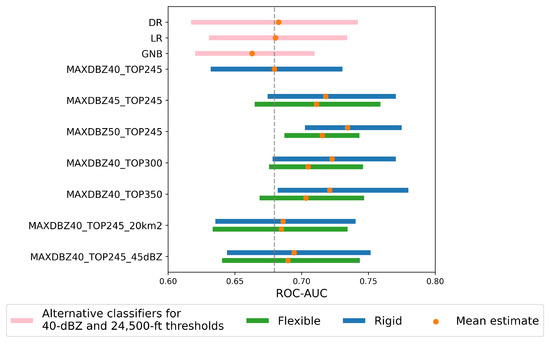
Figure 9.
Cross-validated results of ROC-AUC for the model, compared to other binary classifiers and various alternative versions over 28 iterations, evaluated under both rigid and flexible criteria.
In order to refine our model, the previous analysis is repeated incorporating the other definitions presented in Section 5.1. The corresponding probabilities of deviation are presented in Figure 10. The challenge of unavailable margin values due to increasingly stringent criteria is addressed with flexible definitions. More precisely, if a scenario lacks a margin value, we progressively relax the criteria by considering the next less stringent definition until a value is found or returning to MAXDBZ40_TOP245. For instance, when evaluating the MAXDBZ40_TOP350, if a margin value is unavailable, we check MAXDBZ40_TOP300, and if it is still unavailable, we proceed with MAXDBZ40_TOP245. This approach enables us to fully leverage the benefits of the different model versions. The results of ROC-AUC are gathered in Figure 9 for both rigid and flexible definitions.
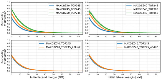
Figure 10.
Comparison of the predicted probabilities of deviation depending on the cell definition for each cross-validation iteration.
The preliminary analysis of the metrics suggests several key insights. First, the explored variations enhance overall performance compared to the default model. In particular, stricter reflectivity and echo top thresholds contribute more significantly to this improvement than additional criteria such as cell size and minimum reflectivity within the cell. Furthermore, the performance gains from increasing reflectivity from 45 dBZ to 50 dBZ and raising the echo top from 30,000 ft to 35,000 ftm appear to be of secondary importance, likely due to the penalization caused by a higher frequency of unavailable margin values. Second, on average, implementing flexible criteria to address unavailable margin values reduces classification ability, despite decreasing dispersion across iterations. In summary, if sorted by their mean rank across the 28 cross-validation iterations, the best version based on the ROC-AUC is the rigid MAXDBZ50_TOP245, while the rigid models MAXDBZ45_TOP245, MAXDBZ40_TOP300, and MAXDBZ40_TOP350 perform similarly. These findings were corroborated through a series of one-sided Wilcoxon signed-rank tests, conservatively adjusting the raw p-values using Bonferroni’s correction [73] to control the inflated false-positive rate from multiple comparisons.
5.3. Assessment of Probabilistic Safety Margins
Using the CDFs estimated in Section 5.2 for MAXDBZ40_TOP245 and its variations, multiple optimal ensembles of M quantiles are built following Equation (3), exploring different values of M. These ensembles are then applied via Equation (4) to generate probabilistic predictions of the lateral margins, which are subsequently evaluated using the MCRPS defined in Equation (8).
Since an ensemble of quantiles discretizes the CDF, the ensemble MCRPS is only an approximation of the MCRPS obtained with the full CDF. As M increases, the ensemble MCRPS converges to that of the CDF, as evidenced in Figure 11. To quantify the discretization error, we computed the MCRPS for increasing values of M and compared it to the CDF-based MCRPS for all cross-validation iterations and cell criteria. Based on this analysis, we selected an ensemble size of 5 members, which is the first odd number (convenient for median calculations) that yields an error below 5%.
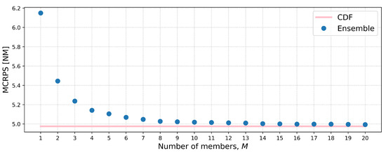
Figure 11.
Illustration of MCRPS convergence with increasing ensemble size for the 40-dBZ and 24,500-ft thresholds, using June 30th and September 14th as validation dates.
Figure 12 presents the resulting ensembles with 5 members. Notably, each ensemble includes at least one member equal to 0. For instance, for the 40 dBZ and 24,500 ft thresholds, the mean estimates of the ensemble members are 0, 0, 0.1, 5.0, and 15.6 NM. As the thresholds become more stringent, the values generally increase, with the second members moving away from zero. For the MAXDBZ40_TOP245_20km2 and MAXDBZ40_TOP245_45dBZ versions, this increase is less pronounced but still evident. Furthermore, higher-order members tend to be more dispersed across iterations; specifically, for the 40 dBZ and 24,500 ft thresholds, the fifth member ranges from 13.5 NM to 16.9 NM.
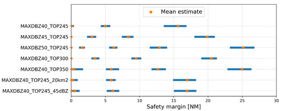
Figure 12.
Cross-validated ensembles with 5 members for various criteria.
The performance of the ensemble model is evaluated compared to the maximum between x and a fixed safety margin s ranging from 0 to 8 NM. The comparison is presented in Figure 13. Note that the deterministic model with always results in the separation distance of planned trajectories x, since margins are non-negative and our model is max(), where max(x,0)=x.
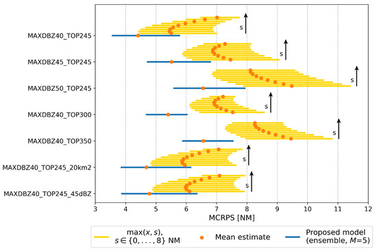
Figure 13.
Cross-validated MCRPS results for the proposed 5-member ensemble-based model, compared against the a model based on a fixed safety margin across various criteria. The arrow indicates the increasing order of the fixed safety margin, ranging from 0 to 8 NM.
The analysis reveals that the proposed model consistently outperforms the separation forecasts of the deterministic model across all its variants. Although a fixed safety margin greater than zero can enhance the performance of the naïve case (with stricter thresholds leading to larger optimal margins, refer to Table 3, and more noticeable improvements), this improvement remains inferior to that achieved by the ensemble-based prediction. For instance, for the 40-dBZ and 24,500-ft thresholds, our model achieves an average MCRPS of 4.4 NM, whereas the optimal fixed safety margin of 2 NM results in an MCRPS of 5.4, nearly matching the 5.5-NM MCRPS of the planned baseline. Moreover, the benefit of the ensemble-based model becomes more pronounced as thresholds become more stringent. While the gain over the performance of the naïve prediction for the 40-dBZ and 24,500-ft thresholds is 1.1 NM, this increases to 2.9 NM when the reflectivity threshold reaches 50 dBZ or the echo top threshold reaches 35,000 ft.
Table 3.
Optimal deterministic safety margins corresponding to each cell definition.
Regarding dispersion, the deterministic baseline generally exhibits greater variability as cell thresholds increase, except for MAXDBZ40_TOP300. In contrast, the proposed probabilistic model effectively mitigates this dispersion. This reduction is especially evident with higher echo top thresholds, notably at 30,000 ft. Once again, the additional criteria of 20 k and 45 dBZ has little impact.
Unlike the assessment of decision-making models, comparing different cell definitions for lateral margin estimations presents inherent challenges. For a start, while decisions were available for all scenarios regardless of the cell definition, lateral margins are not always defined. Some aircraft, particularly non-deviating ones, did not encounter all levels of weather severity, resulting in missing lateral distance values. Second, as thresholds become more stringent, the predicted distances naturally increase since more severe regions are nested within less severe ones. This tendency can lead to larger errors, especially considering that the CRPS generalizes the absolute error. Furthermore, when selecting the most suitable thresholds, priority should be given to the model’s ability to predict pilot decisions accurately. It would be counterproductive to favor a model that, on average, estimates separation more accurately but performs worse in discriminating between deviations and non-deviations.
As a result, we propose the rigid version of MAXDBZ40_TOP300, which balances key advantages: The enhanced deviation discrimination of stricter thresholds (closely matching the skill of the 50-dBZ and 24,500-ft threshold pair), the low and consistent MCRPS of the 40-dBZ and 30,000-ft threshold pair, and the simplicity of defining only one severity level. The final 5-member ensembles needed for this version, averaging across the validation iterations, are summarized in Table 4.
Table 4.
Proposed 5-member ensemble set for modeling aircraft maneuvers in response to convective weather.
These values aid in modeling flight lateral deviations due to the loss of separation from existing convective hazards. According to two ensemble members, aircraft will adhere to their flight plans in the case of a weather encounter but may deviate up to a maximum distance of 20.5 NM, which closely aligns with the general rule of 20 NM.
6. Conclusions
In this paper, we developed an ensemble-based model for lateral aircraft deviations due to the loss of separation from convective hazards, addressing the need for a model tailored to the current European aviation landscape. Given the inherent stochasticity of the problem, we adopted a probabilistic approach to better capture the uncertainty in pilot decision-making.
Utilizing high-resolution traffic and weather radar data across the combined European regions of FABEC and UK-Ireland FAB, we refined an existing algorithm to confidently identify weather-related deviations and non-deviations. After the identification of a significant number of scenarios, we proceeded with the calculation of lateral margins. A key aspect of our methodology was defining a standoff-distance reference based on composite reflectivity contours of 40 dBZ, with echo tops of at least 24,500 ft at some point within the cell. This definition, later fine-tuned through a sensitivity analysis, was chosen to balance practical radar capabilities and standards, vertical extent significance, simplicity, and alignment with the established literature.
To compute meaningful lateral margins, we introduced two simple yet effective geometric algorithms. First, recognizing that pilots often maneuver to avoid multiple convective threats rather than a single triggering cell, we developed a method to select the most relevant weather cells. Second, we devised a strategy to determine lateral margins that accounted for multiple reflectivity contours and frequently update weather radar data. For each scenario (whether a deviation or non-deviation), we returned two margin values: one for the actual trajectory and another for the time-adjusted planned trajectory.
By treating both the initial and final lateral margins relative to the nearest relevant convective cell as random variables, we derived cumulative probability distributions of the safety margins maintained by pilots. This enabled us to predict deviation probabilities based on lateral margins of planned trajectories and, especially, the associated separation distances. The model was rigorously evaluated through a two-step leave-pair-out cross-validation process. First, we assessed its discrimination power against three standard binary classifiers, demonstrating at least comparable performance in distinguishing deviations from non-deviations. Second, we evaluated its ability to probabilistically predict lateral margins in comparison to a deterministic baseline model, consistently demonstrating significantly lower prediction errors.
Following this evaluation and sensitivity analysis, we proposed a 5-member ensemble that effectively balances the enhanced deviation discrimination of stricter thresholds, the low and consistent MCRPS of the 40-dBZ and 30,000-ft threshold pair, and the simplicity of defining only one severity level. This ensemble provides a robust and interpretable framework for modeling lateral deviation behavior in convective environments, offering insights for both operational planning and future research in aviation safety.
Finally, our findings highlight the need to explore specific methods to address key limitations. The primary challenge arises when handling frequent missing data, particularly as thresholds become more stringent. To enhance robustness, adapting interpolation methods such as nearest-neighbor and probabilistic imputation could be beneficial. On the other hand, our findings also suggest promising directions for future research. One potential extension is to incorporate other reflectivity variables, such as vertical reflectivity gradients, and non-precipitation-based criteria, such as lightning strikes, into the model. Additionally, exploring other key parameters in convective weather avoidance maneuvers, such as time to encounter and vertical separation, could provide deeper insights, particularly in assessing potential correlations between them. Another valuable direction would be a systematic comparison between our model and the European adaptation of the well-established Convective Weather Avoidance Model (CWAM) used in the U.S. Moreover, the resulting safety margins will be integrated into a probabilistic aircraft trajectory predictor, enabling more reliable and adaptive decision-making under uncertain convective weather conditions.
Author Contributions
Conceptualization, A.F. and A.V.; methodology, J.N.-P., A.F. and A.V.; software, J.N.-P.; validation, J.N.-P. and A.F.; writing—original draft preparation, J.N.-P.; writing—review and editing, J.N.-P., A.F. and A.V.; funding acquisition, A.F. and A.V. All authors have read and agreed to the published version of the manuscript.
Funding
This paper is part of the R&D&i project PID2021-122323OB-C32, funded by MCIN/AEI/ 10.13039/501100011033/FEDER, UE. Additionally, this research was supported by the VII Plan Propio de Investigación y Transferencia of the University of Seville (VII PPIT-US).
Data Availability Statement
Planned traffic data are available from the https://www.eurocontrol.int/dashboard/rnd-data-archive (accessed on 13 November 2024) R&D Data Archive and requires prior authorization from EUROCONTROL. Actual traffic data can be accessed through the https://opensky-network.org/data/historical-flight-data (accessed on 1 October 2023) Opensky Network upon authorization. Weather radar data was provided by Météo-France; for access, please contact them directly. Geopotential data can be obtained from the https://cds.climate.copernicus.eu/datasets/reanalysis-era5-pressure-levels?tab=download (accessed on 1 October 2023) ERA5 reanalysis dataset with prior authorization. The results of this study are available upon request from the corresponding author.
Acknowledgments
We sincerely thank Nicolas Gaussiat and Milka Radojevic from the Centre de Météorologie Radar (Météo-France) for generously sharing radar weather data. Their invaluable support made this research possible, and we deeply appreciate their willingness to provide access to such critical information. Without their contribution, this work would not have been feasible.
Conflicts of Interest
The authors declare no conflicts of interest.
Abbreviations
| ATFM | Air traffic flow management |
| CDF | Cumulative distribution function |
| CRPS, MCRPS | Continuous ranked probability score, Mean CRPS |
| DR | Decision rule |
| GNB | Gaussian naïve Bayes |
| LR | Logistic regression |
| ROC-AUC | Area under the receiver Operating Characteristic curve |
| VIL | Vertically integrated liquid |
| VIP | Video integrator and processor |
| Nomenclature | |
| Cumulative distribution function | |
| M | Number of ensemble members |
| Dataset sizes for training and validation, respectively | |
| Probability | |
| Stochastic and deterministic safety margin, respectively | |
| Random variable representing the initial lateral margin | |
| and its realization, respectively | |
| Random variable representing the final lateral margin, its realization, | |
| and its estimation, respectively | |
| Subscripts | |
| i | scenario i |
| k | summation index |
| Superscripts | |
| j | ensemble member j |
Appendix A
The process followed to construct the stripe in a given timeframe used in Section 3.2 is illustrated in Figure A1 and described below:
- Let and denote the first and second waypoints, respectively, of the trajectory segment within the time interval and and denote the second-to-last and last waypoints, respectively. Compute the course directions , , and of the segments , , and , respectively.
- Calculate the rhumb line . If , originates at and extends with a constant course of 90° until it intersects the boundary of the relevant cells. Conversely, if , the rhumb line originates at and extends with a constant course of 90° until it intersects the boundary of the relevant cells.
- Calculate the rhumb line . If , originates at and extends with a constant course of 90° until it intersects the boundary of the relevant cells. Conversely, if , the rhumb line originates at and extends with a constant course of 90° until it intersects the boundary of the relevant cells.
- Calculate the rhumb line . If , originates at and extends with a constant course of 90° until it intersects the boundary of the relevant cells. Conversely, if , the rhumb line originates at and extends with a constant course of 90° until it intersects the boundary of the relevant cells.
- Calculate the rhumb line . If , originates at and extends with a constant course of 90° until it intersects the boundary of the relevant cells. Conversely, if , the rhumb line originates at and extends with a constant course of 90° until it intersects the boundary of the relevant cells.
- Define the stripe as the area delimited by rhumb lines , , , , and the boundary of relevant cells.
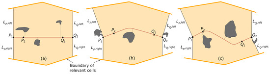
Figure A1.
Graphical method for determining the lateral margin within a given timeframe: (a–c) illustrate examples of stripe geometries.
References
- FAA; US Department of Transportation. Thunderstorms. In Aviation Weather Handbook; Academics, A.S., Ed.; Aviation Supplies & Academics, Inc.: Newcastle, WA, USA, 2022; Chapter 22; pp. 21–22. Available online: https://www.faa.gov/documentLibrary/media/Order/FAA-H-8083-28_Order_8083.28.pdf (accessed on 15 October 2023).
- EASA. The launch edition. In Conversation Aviation; EASA: Cologne, Germany, 2023; p. 37. Available online: https://www.easa.europa.eu/community/system/files/2023-03/Conversation%20Aviation%20-%2001%202023.pdf (accessed on 15 October 2023).
- FAA. Safety of Flight. In Aeronautical Information Manual; Aviation Supplies & Academics, Inc.: Newcastle, WA, USA, 2024; Chapter 7; p. 7-1-26. Available online: https://www.faa.gov/air_traffic/publications/atpubs/aim_html/chap7_section_1.html (accessed on 15 October 2023).
- FAA. Thunderstorms—Don’t flirt...skirt ’em. In FAA Safety Team; Flight Safety Foundation: Alexandria, VA, USA, 2008; p. 2. Available online: https://www.faasafety.gov/files/gslac/library/documents/2011/Aug/56397/FAA%20P-8740-12%20Thunderstorms[hi-res]%20branded.pdf (accessed on 15 October 2023).
- Air Accident Investigation Branch (UK). Airbus A321-231, G-MIDJ; Technical Report; U.K. Department for Transport: Farnborough, UK, 2004; p. 16. [Google Scholar]
- National Air Traffic Services (UK). The Effect of Thunderstorms and Associated Turbulence on Aircraft Operations; Civil Aviation Authority: Hounslow, UK, 2010; pp. 4, 8. [Google Scholar]
- Willett, J.; Merceret, F.; Krider, P.; O’Brien, P.; Dye, J.; Walterscheid, R.; Stolzenburg, M.; Cummins, K.; Christian, H.; Madura, J. Rationales for the lightning launch commit criteria; Technical Report; NASA: Washington, DC, USA, 2016; pp. 30, 36–70. [Google Scholar]
- Marconnet, D.; Norden, C.; Vidal, L. Optimum Use of Weather Radar. In Safety First; Airbus S.A.S: Washington, DC, USA, 2016; pp. 7–12, 20. Available online: https://mms-safetyfirst.s3.eu-west-3.amazonaws.com/pdf/safety+first/optimum-use-of-weather-radar.pdf (accessed on 27 October 2023).
- ECA. Pilots’ Vision on Weather; SESAR JU: Brussels, Belgium, 2014. Available online: https://www.eurocockpit.eu/sites/default/files/2017-04/Pilots%27%20Vision%20on%20Weather%202014_0.pdf (accessed on 18 April 2024).
- ECA. Weather Information to Pilots Strategy Paper; EASA: Cologne, Germany, 2018. Available online: https://www.easa.europa.eu/sites/default/files/dfu/EASA-Weather-Information-to-Pilot-Strategy-Paper.pdf (accessed on 11 April 2024).
- EASA. European Plan for Aviation Safety (EPAS) Volume II—EPAS Actions; Technical Report; EASA: Cologne, Germany, 2024; pp. 19–20. [Google Scholar]
- EASA. Aviation Authorities’ Research Agenda; Technical Report; EASA: Cologne, Germany, 2024; pp. 25–26. [Google Scholar]
- Barber, K.; Mullendore, G. The Importance of Convective Stage on Out-of-Cloud Convectively Induced Turbulence from High-Resolutions Simulations. Mon. Wea. Rev. 2020, 148, 4587–4605. [Google Scholar] [CrossRef]
- Honeywell. Honeywell RDR-7000 Weather Radar: A ’No Brainer’ for Global XRS Pilot Honeywell International, Inc.: Phoenix, AZ, USA. 2020. Available online: https://www.honeywell.com/content/dam/honeywellbt/en/documents/downloads/hon-corp-honeywell-rdr-7000-weather-radar-a-no-brainer-for-global-xrs-pilot.pdf (accessed on 7 June 2024).
- Collins Aerospace. WXR-2100 MultiScan ThreatTrack™ Weather Radar. 2022. Available online: https://www.collinsaerospace.com/what-we-do/industries/commercial-aviation/flight-deck/surveillance/weather-radar/wxr-2100-multiscan-threat-track-weather-radar (accessed on 7 June 2024).
- Rubnich, M.; DeLaura, R. An Algorithm to Identify Robust Convective Weather Avoidance Polygons in En Route Airspace. In Proceedings of the 10th AIAA Technology, Integration, and Operations Conference, Forth Worth, TX, USA, 13–15 September 2010. [Google Scholar]
- Ison, D. Navigating Weather: A Pilot’s Guide to Airborne and Datalink Weather Radar; Aviation Supplies & Academics: Newcastle, WA, USA, 2021; Chapter 2, 3; ISBN 978-1644251249. [Google Scholar]
- García-Heras, J.; Soler, M.; González-Arribas, D.; Eschbacher, K.; Rokitansky, C.; Sacher, D.; Gelhardt, U.; Lang, J.; Hauf, T.; Simarro, J.; et al. Robust flight planning impact assessment considering convective phenomena. Transp. Res. Part C Emerg. 2021, 123, 102968. [Google Scholar] [CrossRef]
- Andrés, E.; García-Heras, J.; González, D.; Soler, M.; Radišić, T.; Andraši, P.; Valenzuela, A.; Franco, A.; Nunez-Portillo, J.; Rivas, D. Probabilistic Analysis of Air Traffic in Adverse Weather Scenarios. In Proceedings of the 10th International Conference on Research in Air Transportation (ICRAT), Tampa, FL, USA, 19–23 June 2022. [Google Scholar]
- Krozel, J.; Mitchell, J.; Polishchuk, V.; Prete, J. Capacity Estimation for Airspaces with Convective Weather Constraints. In Proceedings of the AIAA Guidance, Navigation and Control Conference and Exhibit, Hilton Head, SC, USA, 20–23 August 2007. [Google Scholar] [CrossRef]
- FAA-ATO; Eurocontrol; European Commission. Comparison of Air Traffic Management Related Operational and Economic Performance; Technical Report; FAA-ATO System Operations Services and EUROCONTROL AIU: Blagnac, France, 2024. [Google Scholar]
- Enea, G.; Reynolds, T.; Venuti, J.; Polishchuk, T.; Polishchuk, V.; Lemetti, A.; Lau, A.; Solzer, J.; Bölle, T. Comparing Convective Weather Impacts on Air Traffic Management Operations in United States, Canada & Europe. In Proceedings of the 34th Congress of the International Council of the Aeronautical Sciences, Florence, Italy, 9–13 September 2024. [Google Scholar]
- Taszarek, M.; Allen, J.; Púčik, T.; Hoogewind, K.A.; Brooks, H.E. Severe Convective Storms across Europe and the United States. Part II: ERA5 Environments Associated with Lightning, Large Hail, Severe Wind, and Tornadoes. J. Clim. 2020, 33, 10263–10286. [Google Scholar] [CrossRef]
- Rigo, T.; Farnell, C. Evaluation of the Radar Echo Tops in Catalonia: Relationships with Severe Weather. Remote. Sens. 2022, 14, 6265. [Google Scholar] [CrossRef]
- Eurocontrol. Climate Change Risks for European Aviation 2021. Annex 2: Impact of Changes in Storm Patterns and Intensity on Flight Operations; Technical Report; EUROCONTROL: Brussels, Belgium, 2021; pp. 33–43, 54–55. [Google Scholar]
- Eurocontrol. Forecast Update 2024–2030—Spring 2024; Technical Report; EUROCONTROL: Brussels, Belgium, 2024. [Google Scholar]
- Airbus. Severe Weather Hazards: The Best Is to Anticipate and Avoid. 2024. Available online: https://www.airbus.com/en/newsroom/stories/2024-07-severe-weather-hazards-the-best-is-to-anticipate-and-avoid (accessed on 9 July 2024).
- Saltikoff, E.; Haase, G.; Delobbe, L.; Gaussiat, N.; Martet, M.; Idziorek, D.; Leijnse, H.; Novák, P.; Lukach, M.; Stephan, K. OPERA the Radar Project. Atmosphere 2019, 10, 320. [Google Scholar] [CrossRef]
- Huber, M.; Trapp, J. A Review of NEXRAD Level II: Data, Distribution, and Applications. J. Terr. Obs. 2009, 1, 4. Available online: https://docs.lib.purdue.edu/cgi/viewcontent.cgi?article=1042&context=jto (accessed on 24 October 2024).
- National Transportation Safety Board. Actual Age of NEXRAD Data Can Differ Significantly From Age Indicated on Display. 2015. Available online: https://www.ntsb.gov/Advocacy/safety-alerts/Documents/SA-017.pdf (accessed on 24 October 2024).
- Berberi, L. Maltempo a Milano, la grandine buca il muso dell’aereo diretto a New York: Volo dirottato a Roma. 2023. Available online: https://www.corriere.it/economia/consumi/23_luglio_24/maltempo-milano-grandine-buca-muso-dell-aereo-diretto-new-york-volo-dirottato-roma-8495fe2c-2a32-11ee-84ae-fdab1efa7b6b.shtml (accessed on 24 July 2024).
- Chang, S.; Deng, Y.; Zhang, Y.; Zhao, Q.; Wang, R.; Zhang, K. An Advanced Scheme for Range Ambiguity Suppression of Spaceborne SAR Based on Blind Source Separation. IEEE Trans. Geosci. Remote. Sens. 2022, 60, 5230112. [Google Scholar] [CrossRef]
- Greene, D.; Clark, R. Vertically Integrated Liquid Water – A New Analysis Tool. Mon. Wea. Rev. 1972, 100, 548–552. [Google Scholar] [CrossRef]
- Robinson, M.; Evans, J.; Crowe, B. En Route Weather Depiction Benefits of the NEXRAD Vertically Integrated Liquid Water Product utilized by the Corridor Integrated Weather System. In Proceedings of the 10th Conference on Aviation Range and Aerospace Meteorology, Portland, OR, USA, 12 May 2002; pp. 120–123. [Google Scholar]
- Crowe, B.; Miller, D. The Benefits of Using NEXRAD Vertically Integrated Liquid Water as an Aviation Weather Product. In Proceedings of the 8th Conference on Aviation Range and Aerospace Meteorology, Dallas, TX, USA, 10–15 January 1999. [Google Scholar]
- ICAO. Doc 8896—Manual of Aeronautical Meteorological Practice; ICAO: Montreal, QC, Canada, 2021; p. A8-7. [Google Scholar]
- Hallowell, R.; Wolfson, M.; Forman, B.; Moore, M.; Rotz, T.; Miller, D.; Carty, C.; McGettigan, S. The Terminal Convective Weather Forecast Demonstration at the DFW International Airport. In Proceedings of the 8th Conference on Aviation Range and Aerospace Meteorology, Dallas, TX, USA, 10–15 January 1999. [Google Scholar]
- Temme, M.; Tienes, C. Factors for Pilot’s Decision Making Process to Avoid Severe Weather during Enroute and Approach. In Proceedings of the 2018 IEEE/AIAA 37th Digital Avionics Systems Conference (DASC), London, UK, 23–27 September 2018; pp. 1–10. [Google Scholar]
- Lewis, T.; Burke, K.; Underwood, M.; Wing, D. Weather Design Considerations for the TASAR Traffic Aware Planner. In Proceedings of the AIAA Aviation 2019 Forum, Dallas, TX, USA, 17–21 June 2019. [Google Scholar]
- Benson, L. Severe Weather Survey Report: Pilot Feedback Regarding Weather Deviation Planning; Technical Report; The MITRE Corporation: Bedford, MA, USA, 2003. [Google Scholar]
- DeLaura, R.; Evans, J. An Exploratory Study of Modeling Enroute Pilot Convective Storm Flight deviation behavior. In Proceedings of the 12th Conference on Aviation Range and Aerospace Meteorology, Atlanta, GA, USA, 28 January 2006. [Google Scholar]
- Kuhn, K. Analysis of Thunderstorm Effects on Aggregated Aircraft Trajectories. J. Aerosp. Inf. Syst. 2008, 5, 108–119. [Google Scholar]
- Hauf, T.; Sakiew, L.; Sauer, M. Adverse weather diversion model DIVMET. J. Aerosp. Oper. 2013, 2, 115–133. [Google Scholar] [CrossRef]
- Troxel, S.; Engholm, C. Vertical Reflectivity Profiles: Averaged Storm Structures and Applications to Fan-Beam Radar Weather Detection in the U.S. In Proceedings of the 16th Conference on Severe Local Storms/Conference on Atmospheric Electricity, Kananaskis Provincial Park, AB, Canada, October 1990; pp. 213–218. [Google Scholar]
- Whiton, R.; Smith, P.; Bigler, S.; Wilk, K.; Harbuck, A. History of Operational Use of Weather Radar by U.S. Weather Services. Part I: The Pre-NEXRAD Era. Wea. Forecast. 1998, 13, 219–243. [Google Scholar] [CrossRef]
- Lemon, L.; Quoetone, E.; Milian, N. The U.S. national weather radar testbed (phased array): Potential impact on aviation. In Proceedings of the 31st International Conference on Radar Meteorology, Seattle, WA, USA, 6 August 2003. [Google Scholar]
- Rhoda, D.; Boorman, B.; Bouchard, E.; Isaminger, M.; Pawlak, M. Commercial Aircraft Encounters with Thunderstorms in the Memphis Terminal Airspace. In Proceedings of the 9th Conference on Aviation, Range, and Aerospace Meteorology, Orlando, FL, USA, 12 September 2000. [Google Scholar]
- Bojinski, S.; Blaauboer, D.; Calbet, X.; de Conning, E.; Debie, F.; Montmerle, T.; Nietosvaara, V.; Norman, K.; Bañón, L.; Schmid, F.; et al. Towards nowcasting in Europe in 2030. Meteorol. Appl. 2023, 30, e2124. [Google Scholar] [CrossRef]
- Kober, K.; Tafferner, A. Tracking and nowcasting of convective cells using remote sensing data from radar and satellite. Meteorol. Z. 2009, 1, 75–84. [Google Scholar] [CrossRef]
- Tafferner, A.; Foster, C.; Sénési, S.; Guillou, Y.; Tabary, P.; Laroche, P.; Delannoy, A.; Lunnon, B.; Turp, D.; Hauf, T.; et al. Nowcasting Thunderstorm Hazards for Flight Operations: The CB WIMS Approach in FLYSAFE. In Proceedings of the 26th International Congress of the Aeronautical Sciences, Anchorage, AK, USA, 14–19 September 2008. [Google Scholar]
- FAA. US Department of Transportation. Forecasts. In Aviation Weather Handbook; Academics, A.S., Ed.; U.S. Department of Transportation, Federal Aviation Administration: Washington, DC, USA, 2022; Chapter 27; pp. 27–68. Available online: https://www.faa.gov/documentLibrary/media/Order/FAA-H-8083-28_Order_8083.28.pdf (accessed on 15 October 2023).
- Pascual, R.; Callado, A.; Berenguer, M. Convective storm initiation in central Catalonia. In Proceedings of the 3rd European Conference on Radar in Meteorology and Hydrology, Visby, Sweden, 6–10 September 2004. [Google Scholar]
- Kirk, D.; Bolczak, R. Initial Evaluation of URET Enhancements to Support TFM Flow Initiatives, Severe Weather Avoidance and CPDLC; Technical Report; The MITRE Corporation: Bedford, MA, USA, 2003; p. 5. [Google Scholar]
- Dixon, M.; Wiener, G. TITAN: Thunderstorm Identification, Tracking, Analysis, and Nowcasting–A Radar-based Methodology. JTECH 1993, 10, 785–797. [Google Scholar] [CrossRef]
- Martín, F. Identificación objetiva de estructuras convectivas a partir de los datos radar del PPI/CAPPI bajo McIDAS. In Proceedings of the V Simposio Nacional de Predicción, Madrid, Spain, 20–23 November 2001. [Google Scholar]
- Matthews, M.; DeLaura, R. Evaluation of Enroute Convective Weather Avoidance Models Based on Planned and Observed Flight. In Proceedings of the 14th Conference on Aviation, Range, and Aerospace Meteorology, Atlanta, GA, USA, 16–21 January 2010. [Google Scholar]
- Olive, X.; Basora, L. Detection and identification of significant events in historical aircraft trajectory data. Transp. Res. Part C Emerg 2020, 119, 102737. [Google Scholar] [CrossRef]
- Dalmau, R.; Gawinowski, G. Learning With Confidence the Likelihood of Flight Diversion Due to Adverse Weather at Destination. IEEE Trans. Intell. Transp. Syst. 2023, 24, 5615–5624. [Google Scholar] [CrossRef]
- Dalmau, R.; Gawinowski, G. The effectiveness of supervised clustering for characterising flight diversions due to weather. Expert Syst. Appl. 2024, 237, 121652. [Google Scholar] [CrossRef]
- Gilles, S. The Shapely User Manual. 2024. Available online: https://shapely.readthedocs.io/en/stable/manual.html#the-shapely-user-manual (accessed on 6 May 2024).
- Poelman, D.; Delobbe, L. OD19 Daily Convective Precipitation Maps; Technical Report; EUMETNET: Brussels, Belgium, 2018. [Google Scholar]
- Géron, A. Classification. In Hands-on Machine Learning with Scikit-Learn, Keras, and TensorFlow; O’Reilly Media, Inc.: Sebastopol, CA, USA, 2019; Chapter 3; pp. 99–102. ISBN 978-1-4920-3264-9. [Google Scholar]
- Zamo, M.; Naveau, P. Estimation of the Continuous Ranked Probability Score with Limited Information and Applications to Ensemble Weather Forecasts. Math Geosci. 2018, 50, 209–234. [Google Scholar] [CrossRef]
- Maleki, F.; Muthukrishnan, N.; Ovens, K.; Reinhold, C.; Forghani, R. Machine Learning Algorithm Validation: From Essentials to Advanced Applications and Implications for Regulatory Certification and Deployment. Neuroimaging Clin. North Am. 2020, 30, 437–439. [Google Scholar] [CrossRef]
- Scovell, R.; Al-Sakka, H.; Gaussiat, N.; Tabary, P. A Prototype High Resolution 3D Radar Reflectivity Mosaic for SESAR. In Proceedings of the 8th European Conference on Radar in Meteorology and Hydrology (ERAD), Garmisch-Partenkirchen, Germany, 1–5 September 2014. [Google Scholar]
- Hersbach, H.E.A. The ERA5 global reanalysis. Quart. J. Roy. Meteor. Soc. 2020, 145, 1999–2049. [Google Scholar] [CrossRef]
- Schäfer, M.; Strohmeir, M.; Lenders, V.; Martinovic, I.; Wilhelm, M. Brinding up Opensky: A large-scale ADS-B sensor network for research. In Proceedings of the 13th IEEE/ACM IPSN, Berlin, Germany, 15–17 April 2014; pp. 83–94. [Google Scholar] [CrossRef]
- Olive, X. traffic, a toolbox for processing and analysing air traffic data. J. Open Source Softw. 2019, 4, 1518. [Google Scholar] [CrossRef]
- EASA. Assignment Of Aircraft Types To RECAT-EU Wake Turbulence Categorie. 2021. Available online: https://www.easa.europa.eu/en/downloads/117238/en (accessed on 13 July 2024).
- Pérez-Granja, U.; Pérez-Sánchez, J.; Pérez-Rodríguez, J. Assessing economic performance and aviation accidents using zero-inflated and over-dispersed panel data models. J. Air Transp. Manag. 2024, 118, 102599. [Google Scholar] [CrossRef]
- Wilcoxon, F. Individual Comparisons by Ranking Methods. Biom. Bull. 1945, 1, 80–83. [Google Scholar] [CrossRef]
- Hesterberg, T.; Moore, D.; Monaghan, S.; Clipson, A.; Epstein, R.; McCabe, G. Bootstrap Methods and Permutation Tests. In Introduction to the Practice of Statistics; McCabe, W.H., Ed.; Freeman & Co.: New York, NY, USA, 2005; Chapter 14; pp. 14.47–14.57. [Google Scholar]
- Bonferroni, C. Teoria statistica delle classi e calcolo delle probabilità. Pubbl. R Ist. Super. Sci. Econ. Commer. Firenze 1936, 8, 3–62. [Google Scholar]
Disclaimer/Publisher’s Note: The statements, opinions and data contained in all publications are solely those of the individual author(s) and contributor(s) and not of MDPI and/or the editor(s). MDPI and/or the editor(s) disclaim responsibility for any injury to people or property resulting from any ideas, methods, instructions or products referred to in the content. |
© 2025 by the authors. Licensee MDPI, Basel, Switzerland. This article is an open access article distributed under the terms and conditions of the Creative Commons Attribution (CC BY) license (https://creativecommons.org/licenses/by/4.0/).