Opportunity for GNSS Reflectometry in Sensing the Regional Climate and Soil Moisture Instabilities in Myanmar
Abstract
:1. Introduction
2. Physiography and Climatic Condition of Myanmar
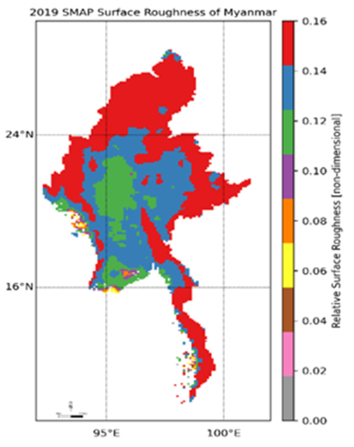
2.1. Surface Roughness
2.2. Climatic Conditions
3. Data Preparation
3.1. CYGNSS L1 Data
3.2. SMAPL3 P Enhanced Data
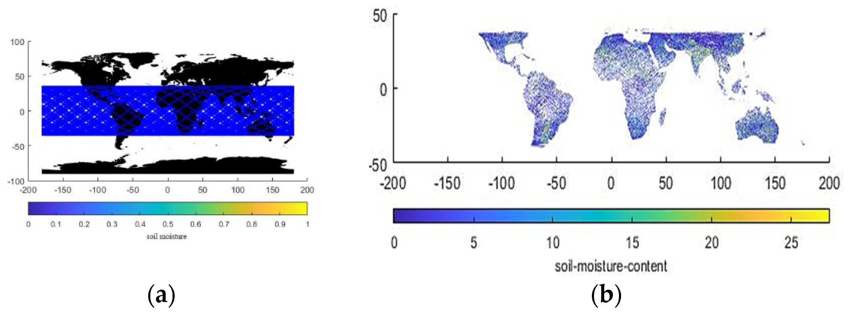
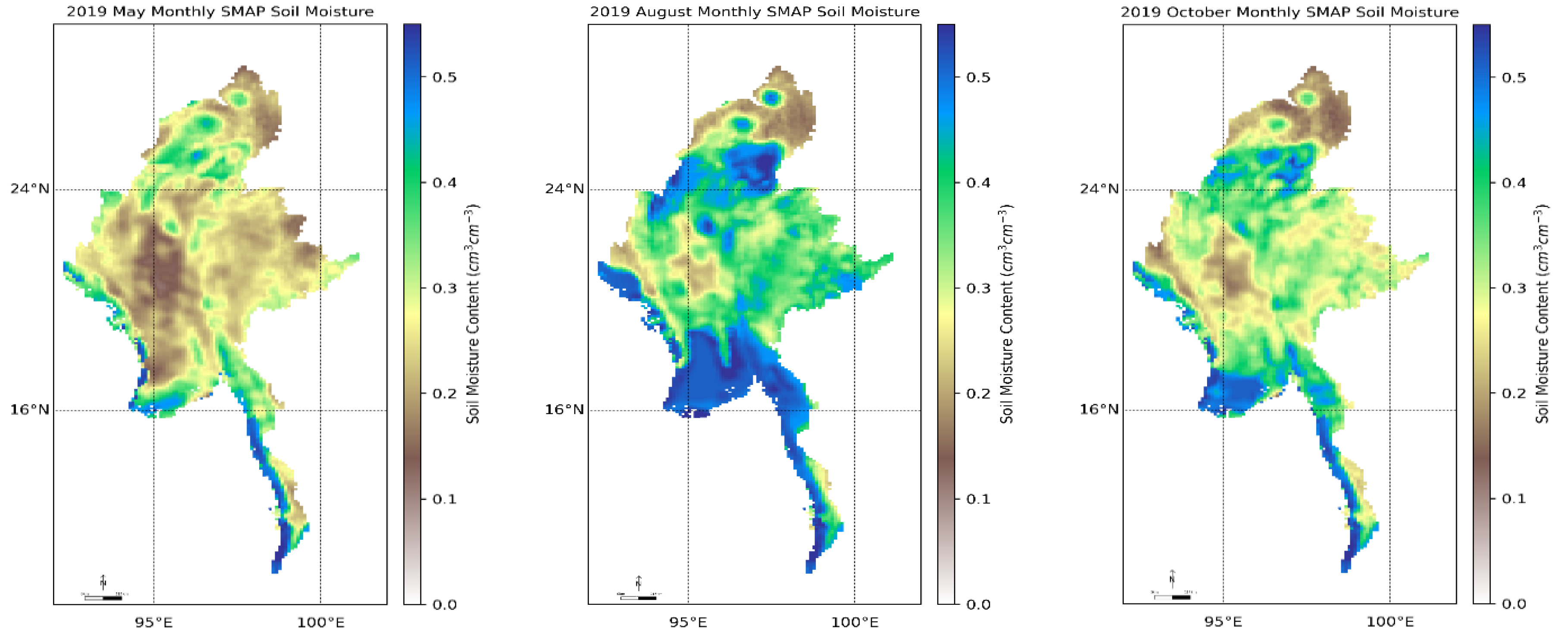
3.2.1. Soil Moisture
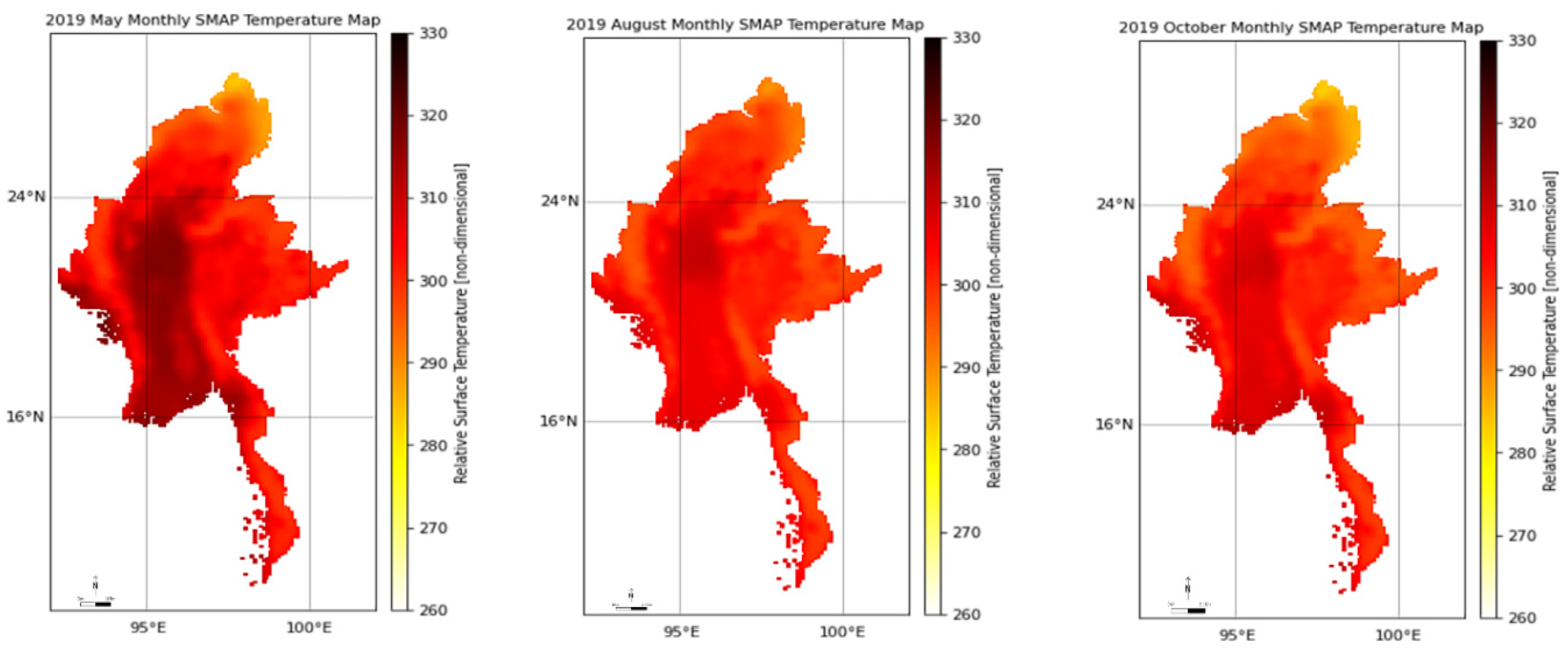
3.2.2. Surface Temperature
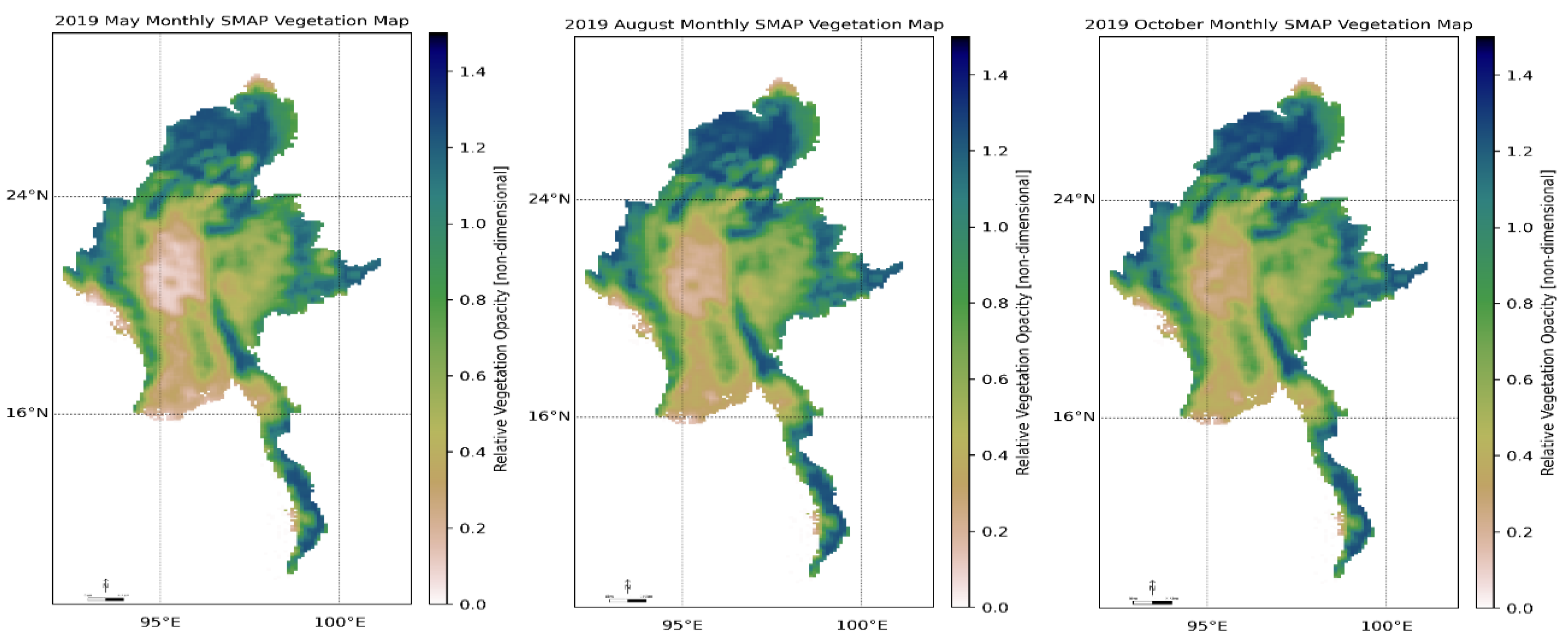
3.2.3. Vegetation Opacity
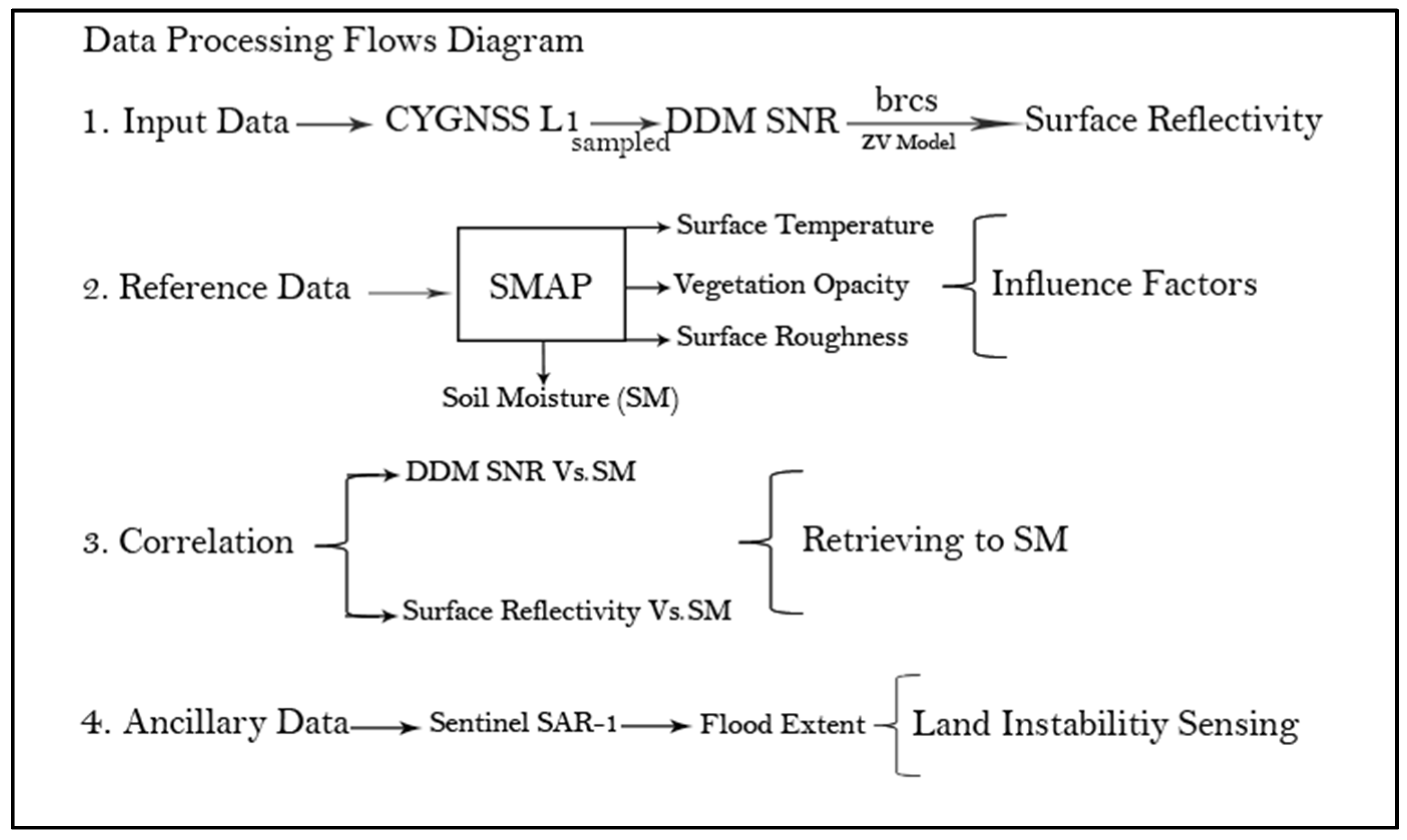
3.3. Processing Flows
4. Results
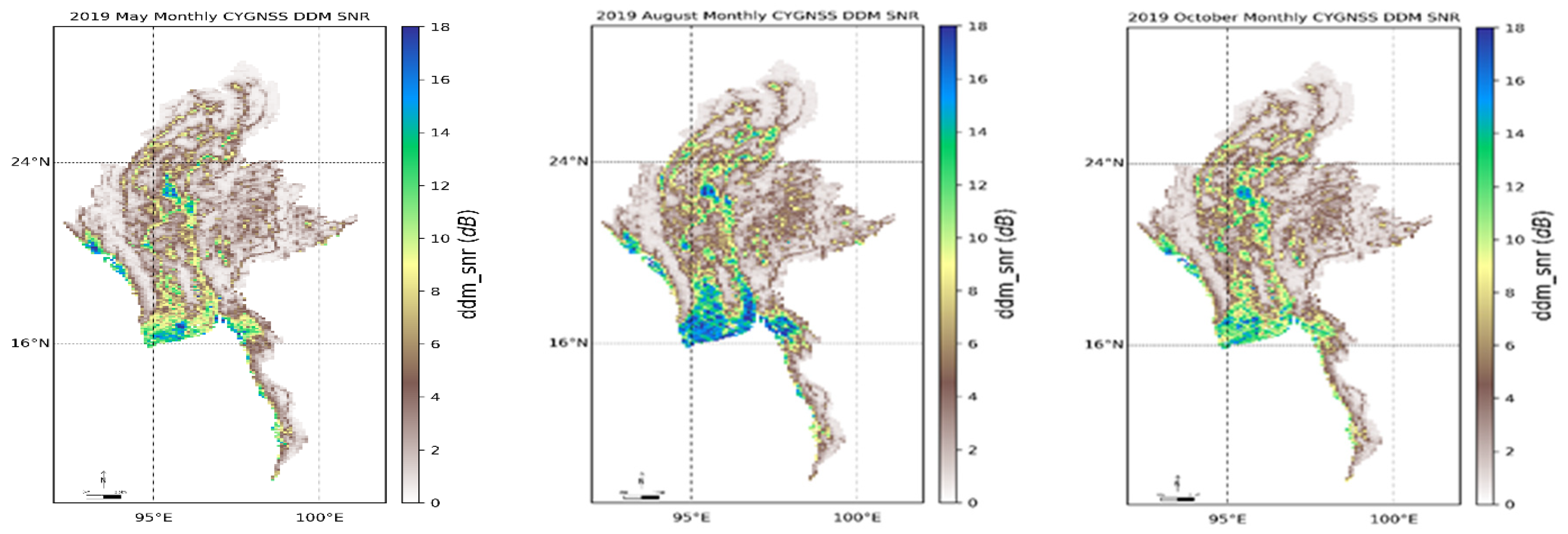
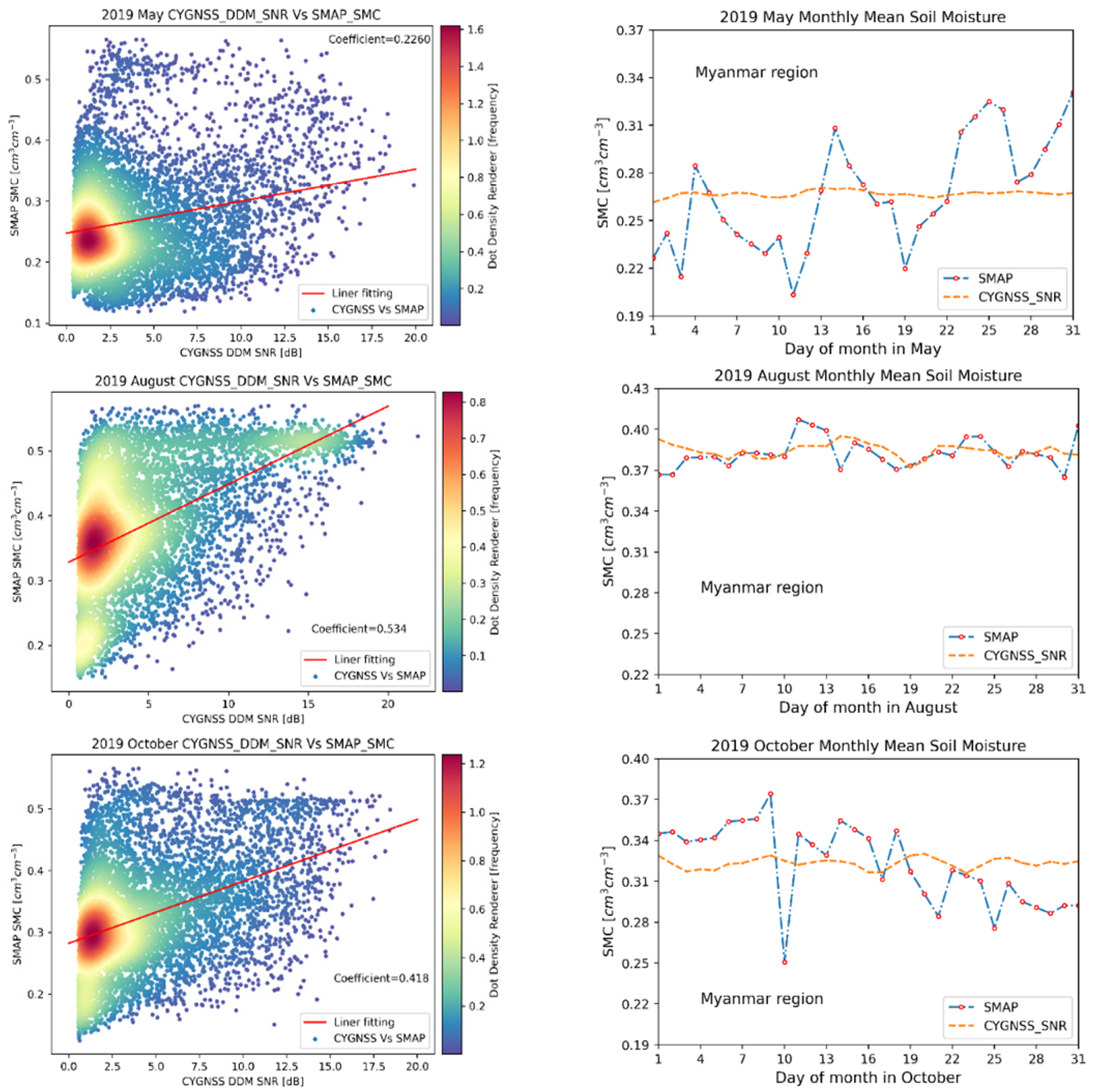
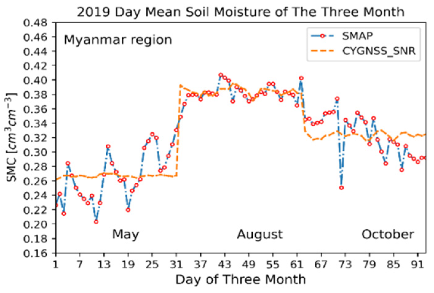
4.1. Soil Moisture Correlation of CYGNSS DDM SNR and SMAP SM
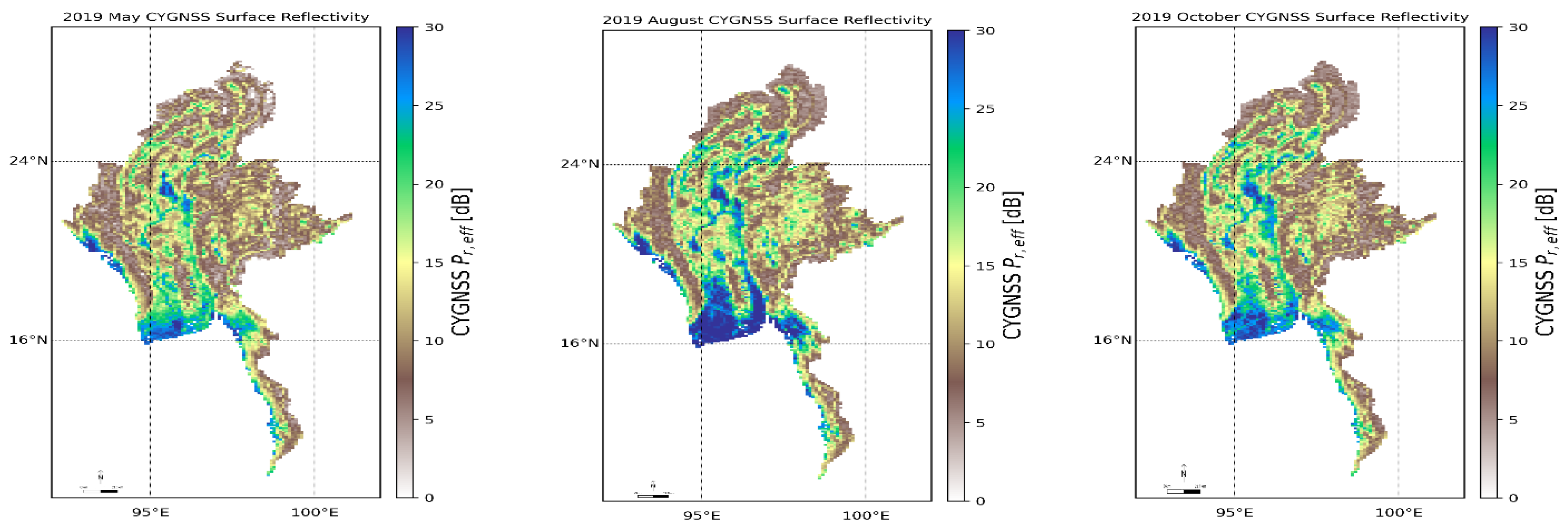
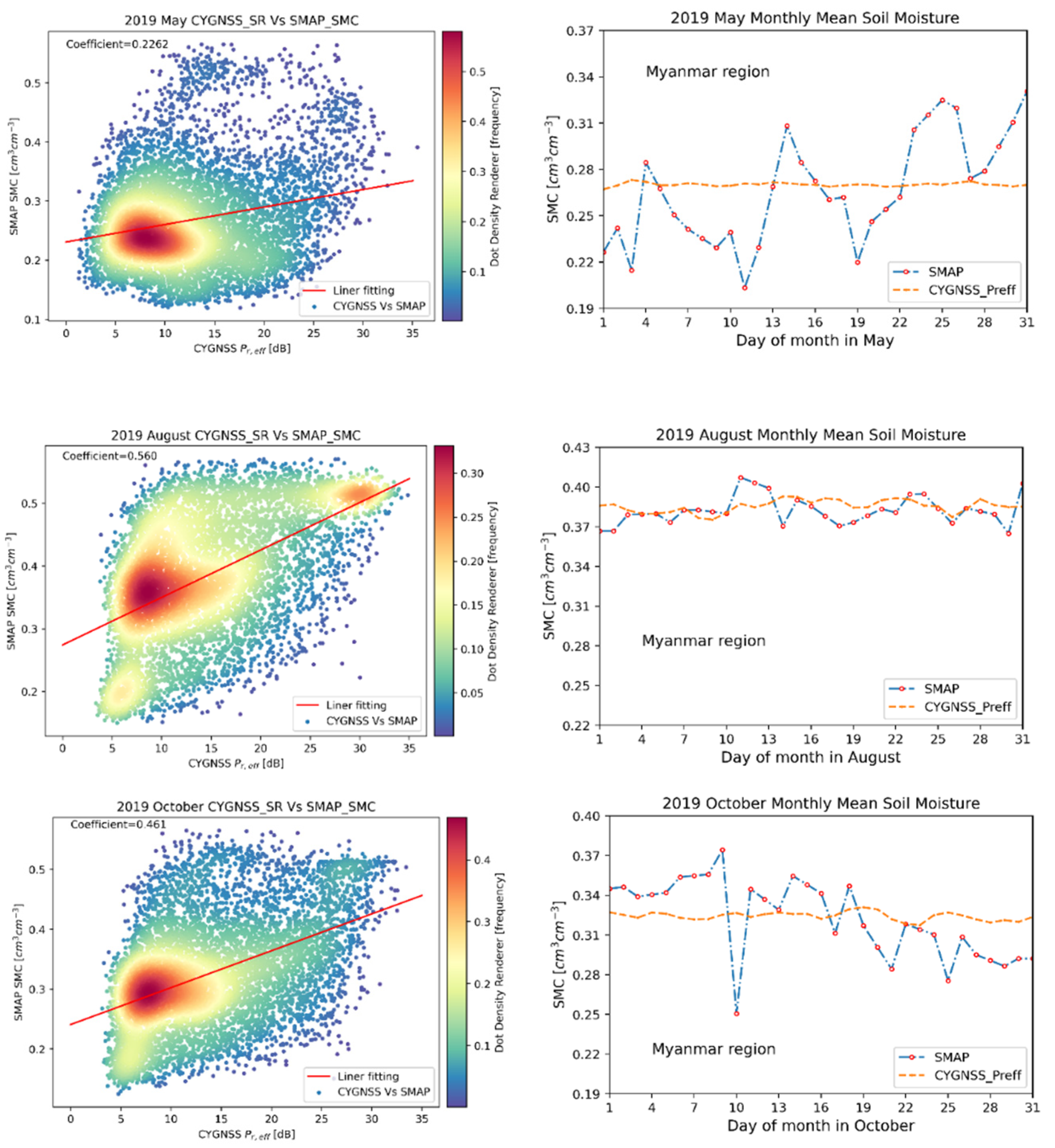
4.2. Soil Moisture Correlation of CYGNSS Surface Reflectivity and SMAP SM
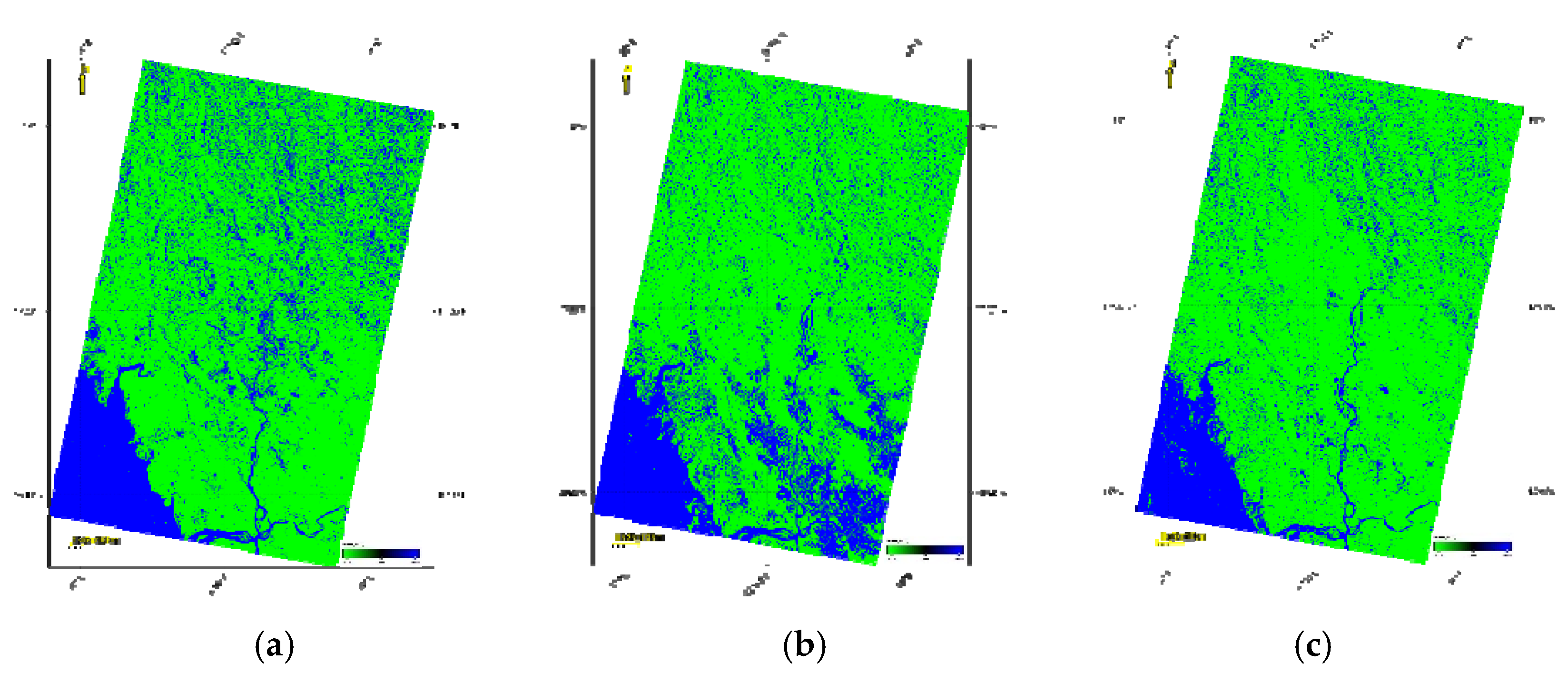
4.3. Data Validation and Verification with SENTINEL SAR-1
5. Discussions
6. Conclusions
Author Contributions
Funding
Institutional Review Board Statement
Informed Consent Statement
Data Availability Statement
Acknowledgments
Conflicts of Interest
References
- Martin-Neira, M.; Caparrini, M.; Font-Rossello, J.; Lannelongue, S.; Vallmitjana, C.S. The PARIS concept: An experimental demonstration of sea surface altimetry using GPS reflected signals. IEEE Trans. Geosci. Remote Sens. 2001, 39, 142–150. [Google Scholar] [CrossRef] [Green Version]
- Camps, A.; Vall·llossera, M.; Park, H.; Portal, G.; Rossato, L. Sensitivity of TDS-1 GNSS-R reflectivity to soil moisture: Global and regional differences and impact of different spatial scales. Remote Sens. 2018, 10, 1856. [Google Scholar] [CrossRef] [Green Version]
- Chew, C.C.; Small, E.E. Soil moisture sensing using spaceborne GNSS reflections: Comparison of CYGNSS reflectivity to SMAP soil moisture. Geophys. Res. Lett. 2018, 45, 4049–4057. [Google Scholar] [CrossRef] [Green Version]
- Clarizia, M.P.; Ruf, C.S.; Jales, P.; Gommenginger, C. Spaceborne GNSS-R minimum variance wind speed estimator. IEEE Trans. Geosci. Remote Sens. 2014, 52, 6829–6843. [Google Scholar] [CrossRef]
- Foti, G.; Gommenginger, C.; Jales, P.; Unwin, M.; Shaw, A.; Robertson, C.; Roselló, J. Spaceborne GNSS reflectometry for ocean winds: First results from the UK TechDemoSat-1 mission. Geophys. Res. Lett. 2015, 42, 5435–5441. [Google Scholar] [CrossRef] [Green Version]
- Chew, C.; Shah, R.; Zuffada, C.; Hajj, G.; Masters, D.; Mannucci, A.J. Demonstrating soil moisture remote sensing with observations from the UK TechDemoSat-1 satellite mission. Geophys. Res. Lett. 2016, 43, 3317–3324. [Google Scholar] [CrossRef] [Green Version]
- Clarizia, M.P.; Ruf, C.S. Wind speed retrieval algorithm for the cyclone global navigation satellite system (CYGNSS) mission. IEEE Trans. Geosci. Remote Sens. 2016, 54, 4419–4432. [Google Scholar] [CrossRef]
- Carreno-Luengo, H.; Luzi, G.; Crosetto, M. Sensitivity of CyGNSS bistatic reflectivity and SMAP microwave radiometry brightness temperature to geophysical parameters over land surfaces. IEEE J. Sel. Top. Appl. Earth Obs. Remote Sens. 2019, 12, 107–122. [Google Scholar] [CrossRef]
- Wan, W.; Liu, B.; Zeng, Z.; Chen, X.; Wu, G.; Xu, L.; Chen, X.; Hong, Y. Using CYGNSS data to monitor China’s flood inundation during typhoon and extreme precipitation events in 2017. Remote Sens. 2019, 11, 854. [Google Scholar] [CrossRef] [Green Version]
- Rodriguez-Alvarez, N.; Misra, S.; Podest, E.; Morris, M.; Bosch-Lluis, X. The use of SMAP-reflectometry in science applications: Calibration and capabilities. Remote Sens. 2019, 11, 2442. [Google Scholar] [CrossRef] [Green Version]
- Wang, J.R.; Schmugge, T.J. An empirical model for the complex dielectric permittivity of soils as a function of water content. IEEE Trans. Geosci. Remote Sens. 1980, GE-18, 288–295. [Google Scholar] [CrossRef] [Green Version]
- Njoku, E.G.; Chan, S.K. Vegetation and surface roughness effects on AMSR-E land observations. Remote Sens. Environ. 2006, 100, 190–199. [Google Scholar] [CrossRef]
- Masters, D.S. Surface Remote Sensing Applications of GNSS Bistatic Radar: Soil Moisture and Aircraft Altimetry; University of Colorado: Boulder, CO, USA, 2004. [Google Scholar]
- Egido, A. GNSS Reflectometry for Land Remote Sensing Applications. Ph.D. Thesis, Universitat Politècnica de Catalunya, Barcelona, Spain, 2013. [Google Scholar]
- Chew, C.; Small, E. Description of the UCAR/CU soil moisture product. Remote Sen. 2020, 12, 1558. [Google Scholar] [CrossRef]
- Gavahi, K.; Abbaszadeh, P.; Moradkhani, H.; Zhan, X.; Hain, C. Multivariate assimilation of remotely sensed soil moisture and evapotranspiration for drought monitoring. J. Hydrometeorol. 2020, 21, 2293–2308. [Google Scholar] [CrossRef]
- Humphrey, V.; Berg, A.; Ciais, P.; Gentine, P.; Jung, M.; Reichstein, M.; Seneviratne, S.I.; Frankenberg, C. Soil moisture-atmosphere feedback dominates land carbon uptake variability. Nature 2021, 592, 65–69. [Google Scholar] [CrossRef] [PubMed]
- Dong, Z.; Jin, S. Evaluation of the land GNSS-reflected DDM coherence on soil moisture estimation from CYGNSS data. Remote Sens. 2021, 13, 570. [Google Scholar] [CrossRef]
- Pierdicca, N.; Comite, D.; Carreno-Luengo, H.; Cenci, L.; Clarizia, M.P.; Guerriero, L.; Paloscia, S.; Santi, E. Potential of spaceborne GNSS reflectometry for soil moisture, biomass and freeze-thaw monitoring: Summary of an ESA-funded study. IEEE Geosci. Remote Sens. Mag. 2021. [Google Scholar] [CrossRef]
- Senyurek, V.; Lei, F.; Boyd, D.; Gurbuz, A.C.; Kurum, M.; Moorhead, R. Evaluations of machine learning-based CYGNSS soil moisture estimates against SMAP observations. Remote Sens. 2020, 12, 3503. [Google Scholar] [CrossRef]
- Myanmar Climate Change Strategy: (2018–2030); Environmental Conservation Department, Ministry of Natural Resources and Environmental Conservation: Naypyidaw, Myanmar, 2019; p. 18.
- Eroglu, O.; Kurum, M.; Boyd, D.; Gurbuz, C.A. High spatio-temporal resolution CYGNSS soil moisture estimates using artificial neural networks. Remote Sens. 2019, 11, 2272. [Google Scholar] [CrossRef] [Green Version]
- Zavorotny, V.U.; Gleason, S.; Cardellach, E.; Camps, A. Tutorial on remote sensing using GNSS bistatic radar of opportunity. IEEE Geosci. Remote Sens. Mag. 2014, 2, 8–45. [Google Scholar] [CrossRef] [Green Version]
- CYGNSS. 2018. CYGNSS Level 1 Science Data Record Version 2.1. Ver. 2.1. PO.DAAC, CA, USA. Available online: https://doi.org/10.5067/CYGNS-L1X21 (accessed on 9 December 2019).
- Brodzik, M.J.; Knowles, K.W. Chapter 5: EASE-Grid: A versatile set of equal-area projections and grids. In Discrete Global Grids: A Web Book; Goodchild, M.F., Ed.; National Center for Geographic Information & Analysis: Santa Barbara, CA, USA, 2002. [Google Scholar]
- The New York Times News. 12 August 2019, Sec A, p. 8.
- Sen Roy, N.; Kaur, S. Climatology of monsoon rains of Myanmar (Burma). Int. J. Climatol. J. R. Meteorol. Soc. 2000, 20, 913–928. [Google Scholar] [CrossRef]
- Chan, S. SMAP Enhanced Level 3 Passive Soil Moisture Data Product Specification Document; Jet Propulsion Laboratory, California Institute of Technology: Pasadena, CA, USA, 2021; p. 6. [Google Scholar]
- O’Neill, P.E.; Chan, S.; Njoku, E.G.; Jackson, T.; Bindlish, R.; Chaubell, J. SMAP Enhanced L3 Radiometer Global Daily 9 km EASE-Grid Soil Moisture, Version 3. [Myanmar Part]. NASA National Snow and Ice Data Center Distributed Active Archive Center: Boulder, CO, USA, 2019. Available online: https://doi.org/10.5067/T90W6VRLCBHI (accessed on 9 December 2019).
- Entekhabi, D.; Yueh, S.; O’Neill, P.E.; Kellogg, K.H.; Allen, A.; Bindlish, R.; West, R. SMAP Handbook, Soil Moisture Active Passive: Mapping Soil Moisture and Freeze/Thaw from Space; The Jet Propulsion Laboratory, California Institute of Technology, under a contract with the National Aeronautics and Space Administration: Los Angeles, CA, USA, 2014; p. 47. [Google Scholar]
- Taft, L.; Evers, M. A review of current and possible future human–water dynamics in Myanmar’s river basins. Hydrol. Earth Syst. Sci. 2016, 20, 4913–4928. [Google Scholar] [CrossRef] [Green Version]
- Mo, T.; Choudhury, B.J.; Schmugge, T.J.; Wang, J.R.; Jackson, T.J. A model for microwave emission from vegetation-covered fields. J. Geophys. Res.: Ocean 1982, 87, 11229–11237. [Google Scholar] [CrossRef]
- Zheng, D.; Wang, X.; Van Der Velde, R.; Ferrazzoli, P.; Wen, J.; Wang, Z.; Schwank, M.; Colliander, A.; Bindlish, R.; Su, Z. Impact of surface roughness, vegetation opacity and soil permittivity on L-band microwave emission and soil moisture retrieval in the third pole environment. Remote Sens. Environ. 2018, 209, 633–647. [Google Scholar] [CrossRef]
- Katzberg, S.J.; Garrison, J.L. Utilizing GPS to determine ionospheric delay over the ocean. Nasa Tech. Memo. NASA-TM-4750 1996, 1–16. [Google Scholar]
- CYGNSS Instrument Overview. CYGNSS Project: Surrey Satellite Technology Ltd. /University of Michigan.
- Flood News in Asia. Myanmar—over 40 killed by Landslide in Mon State.
- Myanmar Floods News—Jul 2019. Reliefweb, OCHA services.
- Saillard, M.; Roo, R.D.D.; Ulaby, F.T. Comments on “Bistatic specular scattering from rough dielectric surfaces” [with reply]. IEEE Trans. Antennas Propag. 1995, 43, 224–226. [Google Scholar] [CrossRef]
- Emergency Plan of Action Operation Update Myanmar: Monsoon Floods. Situational Report IFRC, 22 Aug 2019.
- Uddin, K.; Matin, M.A.; Meyer, F.J. Operational flood mapping using multi-temporal sentinel-1 SAR images: A case study from bangladesh. Remote Sens. 2019, 11, 1581. [Google Scholar] [CrossRef] [Green Version]
- Rajabi, M.; Nahavandchi, H.; Hoseini, M. Evaluation of CYGNSS observations for flood detection and mapping during Sistan and Baluchestan torrential rain in 2020. Water 2020, 12, 2047. [Google Scholar] [CrossRef]
- Unnithan, S.L.; Biswal, B.; Rüdiger, C. Flood inundation mapping by combining GNSS-R signals with topographical information. Remote Sens. 2020, 12, 3026. [Google Scholar] [CrossRef]
- Nghiem, S.V.; Zuffada, C.; Shah, R.; Chew, C.; Lowe, S.T.; Mannucci, A.J.; Rosenqvist, A. Wetland monitoring with Global Navigation Satellite System reflectometry. Earth Space Sci. 2017, 4, 16–39. [Google Scholar] [CrossRef]
- Dobson, M.C.; Ulaby, F.T.; Hallikainen, M.T.; El-Rayes, M.A. Microwave dielectric behavior of wet soil—Part 1 & II: Dielectric mixing models. IEEE Trans. Geosci. Remote Sens. 1985, GE-23, 35–46. [Google Scholar]

| Parameter(s) | Microwave > Brightness Temperature Soils > Soil Moisture/Water Contents > Soil Moisture |
|---|---|
| Spatial Coverage | N: 85.044, S: −85.044, E: 180, W: −180 |
| Spatial Resolution | 9 km × 9 km |
| Temporal Coverage | 31 March 2015 to 27 August 2020 |
| Temporal Resolution | 1 Day |
| Data Format(s) | HDF5 |
| Platform(s) | SMAP |
| Sensor(s) | SMAP L-Band Radiometer |
| Version(s) | V3 |
| Data Contributor(s) | O’Neill, P. E., S. Chan, E. G. Njoku, T. Jackson, R. Bindlish, and J. Chaubell. |
| Observed Date (2019) (Monthly) | DDM SNR vs. SMAP SM (Coefficient Value) | Surface Reflectivity vs. SMAP SM (Coefficient Value) |
|---|---|---|
| May | 0.2260 | 0.2262 |
| August | 0.534 | 0.560 |
| October | 0.418 | 0.461 |
Publisher’s Note: MDPI stays neutral with regard to jurisdictional claims in published maps and institutional affiliations. |
© 2021 by the authors. Licensee MDPI, Basel, Switzerland. This article is an open access article distributed under the terms and conditions of the Creative Commons Attribution (CC BY) license (https://creativecommons.org/licenses/by/4.0/).
Share and Cite
Lwin, A.; Yang, D.; Hong, X.; Zhang, B.; Zhang, B.; Sara, C.S. Opportunity for GNSS Reflectometry in Sensing the Regional Climate and Soil Moisture Instabilities in Myanmar. Climate 2021, 9, 175. https://doi.org/10.3390/cli9120175
Lwin A, Yang D, Hong X, Zhang B, Zhang B, Sara CS. Opportunity for GNSS Reflectometry in Sensing the Regional Climate and Soil Moisture Instabilities in Myanmar. Climate. 2021; 9(12):175. https://doi.org/10.3390/cli9120175
Chicago/Turabian StyleLwin, Aung, Dongkai Yang, Xuebao Hong, Bo Zhang, Baoyin Zhang, and Cheraghi Shamsabadi Sara. 2021. "Opportunity for GNSS Reflectometry in Sensing the Regional Climate and Soil Moisture Instabilities in Myanmar" Climate 9, no. 12: 175. https://doi.org/10.3390/cli9120175
APA StyleLwin, A., Yang, D., Hong, X., Zhang, B., Zhang, B., & Sara, C. S. (2021). Opportunity for GNSS Reflectometry in Sensing the Regional Climate and Soil Moisture Instabilities in Myanmar. Climate, 9(12), 175. https://doi.org/10.3390/cli9120175


