Indigenous Knowledge and Farmer Perceptions of Climate and Ecological Changes in the Bamenda Highlands of Cameroon: Insights from the Bui Plateau


Abstract
1. Introduction
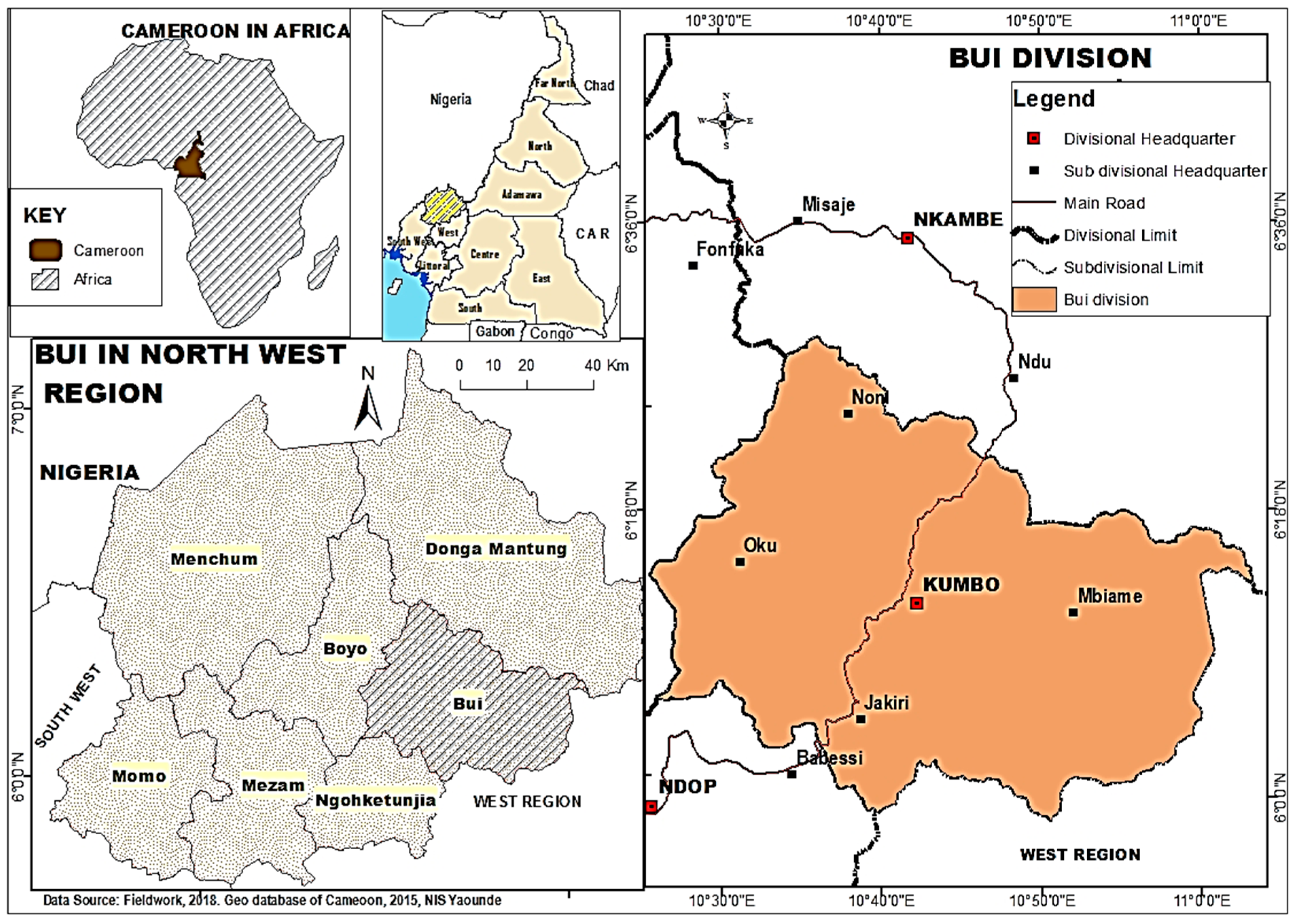
2. Materials and Methods
3. Results
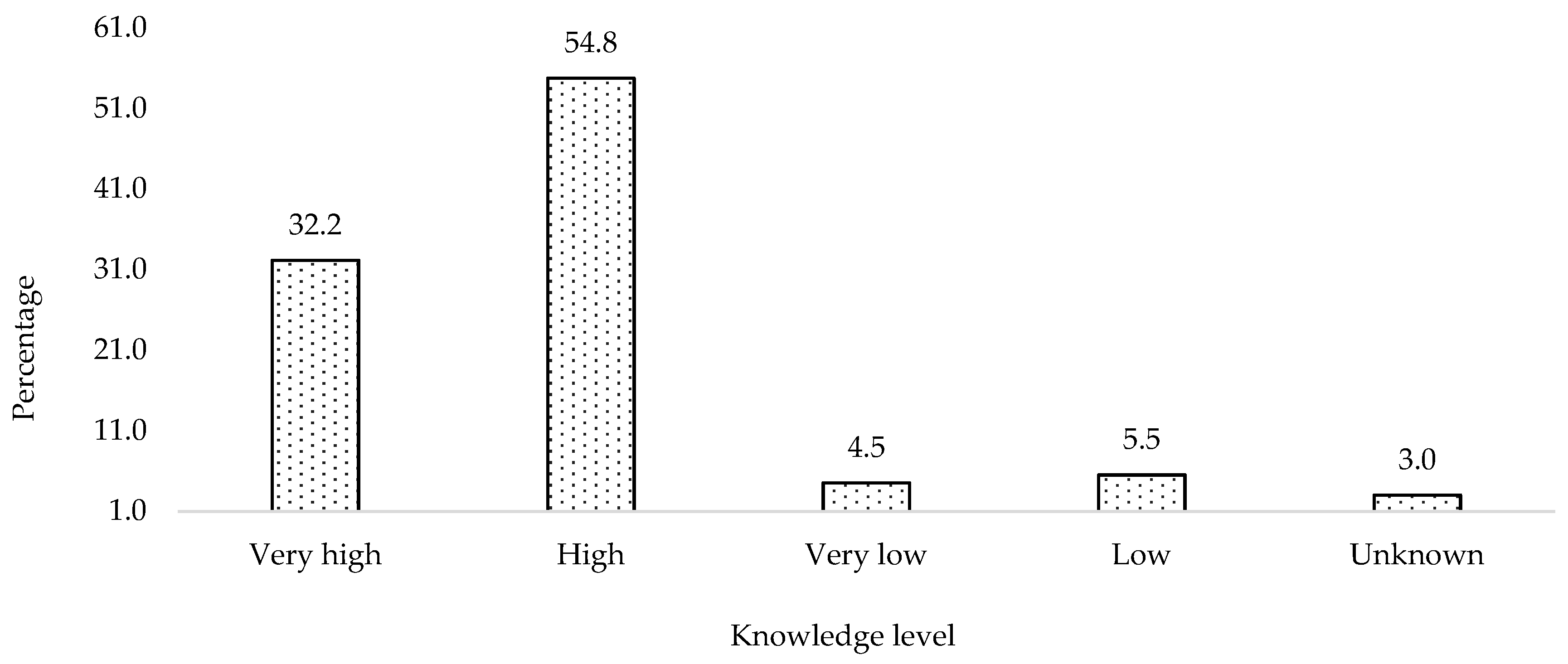
3.1. Indigenous Knowledge Levels and Sources
3.2. Community Knowledge for Agrarian Weather Forecasting
3.3. Local and Scientific Weather Knowledge in Agrarian Practices
3.4. Agro-Hydro-Ecological Indicators of Climate Variability in Bui
4. Discussion
5. Conclusions
Author Contributions
Funding
Acknowledgments
Conflicts of Interest
References
- Nakashima, D.J.; Galloway McLean, K.; Thulstrup, H.D.; Ramos Castillo, A.; Rubis, J.T. Weathering Uncertainty: Traditional Knowledge for Climate Change Assessment and Adaptation; UNESCO & Darwin, UNU: Paris, France, 2012; p. 120. [Google Scholar]
- Kimengsi, J.N.; Amawa, S.G.; Fondufe, S.L. Building a Strategy to Overcome the Psychological Barriers to Climate Change Management in Rural Communities of Fako Division, Cameroon. J. Sustain. Dev. 2016, 9, 14–22. [Google Scholar] [CrossRef]
- Bate, G.B.; Kimengsi, J.N.; Amawa, S.G. Determinants and Policy Implications of Farmers’ Climate Adaptation Choices in Rural Cameroon. Sustainability 2019, 11, 1921. [Google Scholar] [CrossRef]
- Gyampoh, B.A.; Amisah, S.; Idinoba, M.; Nkem, J. Using Traditional Knowledge to Cope with Climate Change in Rural Ghana. Unasylva (Engl. Ed.) 2009, 60, 70–74. [Google Scholar]
- Mafongoya, P.L.; Ajayi, O.C. (Eds.) Indigenous Knowledge Systems and Climate Change Management in Africa; CTA: Wageningen, The Netherlands, 2017; pp. 17–28. [Google Scholar]
- Abeysinghe, A.C. Addressing Climate Adaptation through Equity Concepts. International Institute for Environment and Development (IIED); Briefing: London, UK, 2013; pp. 1–4. [Google Scholar]
- Nchu, I.N.; Kimengsi, J.N.; Kapp, G. Diagnosing climate adaptation constraints in rural subsistence farming systems in Cameroon. Gender and institutional perspectives. Sustainability 2019, 11, 3767. [Google Scholar] [CrossRef]
- Boansi, D.; Tambo, J.A.; Muller, M. Analysis of farmers’ Adaptation to Weather extremes in West African Sudan Savanna. Weather Clim. Extrem. 2017, 16, 1–13. [Google Scholar] [CrossRef]
- UNESCO. Local and Indigenous Knowledge Systems (LINKS). 2015. Available online: http://portal.unesco.prg/science/en/ev.phpURL_ID=2031&URL_DO=DO_TOPIC&URL_SECTION=20html (accessed on 27 September 2019).
- Swiderska, K.; Malmer, P. Climate Change and Biocultural Adaptation in Mountain Communities: Second International Learning Exchange of the International Network of Mountain Indigenous People (INMIP); International Institute for Environment and Development: London, UK, 2016; p. 46. [Google Scholar]
- Hiwasaki, L.; Luna, E.; Syamsidik Shaw, R. Local and Indigenous Knowledge for Community Resilience: Hydro-meteorological Disaster Risk Reduction and Climate Change Adaptation in Coastal and Small Island Communities; UNESCO: Jakarta, Indonesia, 2014; p. 60. [Google Scholar]
- Egan, A. Knowledge Management Strategy on Climate Change Adaptation for Cameroon; Ministry of the Environment, Protection of Nature and Sustainable Development: Yaoundé, Cameroon, 2013; pp. 17–19. [Google Scholar]
- Kolawole, D.O.; Motsholapheko, M.R.; Ngwenya, B.N.; Thakadu, O. Climate Variability and Rural Livelihoods: How Households Perceive and Adapt to Climatic Shocks in the Okavango Delta, Botswana. Am. Meteorol. Soc. 2016, 8, 131–145. [Google Scholar] [CrossRef]
- Rhodes, E.R.; Jalloh, A.; Diouf, A. Review of Research and Policies for Climate Change Adaptation in the Agriculture Sector in West Africa; Future Agricultures, Working Paper Number 090; University of Sussex: Brighton, UK, 2014; pp. 12–18. [Google Scholar]
- Macchi, M.; Boedhihartono, A.; Wolfangel, C.; Howell, M.; Oviedo, G.; Gotheil, S.; Cross, K. Indigenous and Traditional Peoples and Climate Change; International Union for Conservation of Nature: Gland, Switzerland, 2008; pp. 9–22. [Google Scholar]
- Fernández-Llamazares, Á.; Díaz-Reviriego, I.; Luz, A.C.; Cabeza, M.; Pyhälä, A.; Reyes-Garcia, V. Rapid Ecosystem Change Challenges the Adaptive Capacity of Local Environmental Knowledge. Glob. Environ. Chang. 2015, 31, 272–284. [Google Scholar] [CrossRef]
- Mwaura, P. Indigenous Knowledge in Disaster Management in Africa; UNEP: Nairobi, Kenya, 2008; pp. 21–33. [Google Scholar]
- Briggs, J. The Use of Indigenous Knowledge in Development: Problems and Challenges. Prog. Dev. Stud. 2005, 5, 99–114. [Google Scholar] [CrossRef]
- Senanayake, S. Indigenous Knowledge as a Key to Sustainable Development. J. Agric. Sci. 2006, 2, 87–94. [Google Scholar] [CrossRef]
- Beckford, C.; Barker, D. The Role and Value of Local Knowledge in Jamaican Agriculture: Adaptation and Change in Small-scale Farming. Geogr. J. 2007, 173, 118–128. [Google Scholar] [CrossRef]
- Odero, K. The Role of Indigenous Knowledge in Responding to Climate Change: Local-global Perspectives. Panel 10: Roles of Local and Indigenous Knowledge in Addressing Climate Change. In Proceedings of the African Adapt, Climate Change Symposium, Addis Ababa, Ethiopia, 9–11 March 2011. [Google Scholar]
- Mafongoya, P.L.; Jiri, O.; Mubaya, C.P.; Mafongoya, O. Using indigenous knowledge for seasonal quality prediction in managing climate risk in Sub-Saharan Africa. In Indigenous Knowledge Systems and Climate Change Management in Africa; Mafongoya, P.L., Ajayi, O.C., Eds.; CTA: Wageningen, The Netherlands, 2017; pp. 43–66. [Google Scholar]
- United Nations Convention on Climate Change-UNFCCC. UNFCCC Handbook; UNFCCC Secretariat: Bonn, Germany, 2006; p. 26. [Google Scholar]
- Baird, R. The Impact of Climate Change on Minorities and Indigenous Peoples. In Minority Rights Group International; Briefing: London, UK, 2008; p. 12. [Google Scholar]
- Bolden, I.W.; Seroy, S.K.; Roberts, E.A.; Schmeisser, L.; Koehn, J.Z.; Rilometo, C.H.; Odango, E.L.; Barros, C.; Sachs, J.P.; Klinger, T. Climate-related community knowledge networks as a tool to increase learning in the context of environmental change. Clim. Risk Manag. 2018, 21, 1–6. [Google Scholar]
- International Institute for Environment and Development-IIED. Vulnerable Communities: Getting their Needs and Knowledge into Climate Policy; IIED Briefing: London, UK, 2015; pp. 1–4. [Google Scholar]
- International Institute for Environment and Development-IIED. Vulnerable Communities: Climate Adaptation that Works for the Poor; IIED Briefing: London, UK, 2015; pp. 1–4. [Google Scholar]
- International Institute for Environment and Development-IIED. Biocultural Innovation: The Key to Global Food Security? IIED: London, UK, 2018; pp. 1–4. [Google Scholar]
- Jamshidi, O.; Asadi, A.; Kalantari, K.; Azadi, H. Perception, Knowledge and Behaviour towards Climate Change: A survey among Agricultural Professionals in Hamadan Province, Iran. J. Agric. Sci. Technol. 2018, 20, 1369–1382. [Google Scholar]
- Fabayi, O.O.; Oloukoi, J. Indigenous Knowledge System and Local Adaptation Strategies for Flooding in Coastal Rural Communities of Nigeria. J. Indig. Soc. Dev. 2013, 2, 1–19. [Google Scholar]
- Okonya, J.S.; Ajayi, O.C.; Mafongoya, P.L. The role of indigenous knowledge in seasonal weather forecasting and planning of farm activities by rural crop farmers in Uganda. In Indigenous Knowledge Systems and Climate Change Management in Africa; Mafongoya, P.L., Ajayi, O.C., Eds.; CTA: Wageningen, The Netherlands, 2017; pp. 239–254. [Google Scholar]
- Nanja, D.H. Indigenous knowledge in weather and seasonal rainfall prediction in Zambia. In Indigenous Knowledge Systems and Climate Change Management in Africa; Mafongoya, P.L., Ajayi, O.C., Eds.; CTA: Wageningen, The Netherlands, 2017; pp. 295–308. [Google Scholar]
- United Nations Permanent Forum on Indigenous Issues-UNPFII. Climate Change and Indigenous Peoples; Indigenous Peoples, Indigenous Voices: New York, NY, USA, 2008; p. 3. [Google Scholar]
- Niles, M.T.; Mueller, N.D. Farmer Perceptions of Climate Change: Associations with Observed Temperature and Precipitation Trends, Irrigation, and Climate Beliefs. Glob. Environ. Chang. 2016, 39, 133–142. [Google Scholar] [CrossRef]
- Krishna, V. Indigenous Communities and Climate Change Policy: An Inclusive Approach. In The Economic, Social and Political Elements of Climate Change; Springer: Cham, Switzerland, 2011; pp. 27–49. [Google Scholar]
- International Labour Organisation-ILO. Indigenous Peoples and Climate Change: From Victims to Change Agents through Decent Work; ILO Office: Geneva, Switzerland, 2017; p. 45. [Google Scholar]
- Government of Nepal. Mainstreaming Climate Change Risk Management in Development; Ministry of Science, Technology and Environment: Kathmandu, Nepal, 2017; p. 9.
- Nyong, A.; Adesina, F.; Elasha, B.O. The Value of Indigenous Knowledge in Climate Change Mitigation and Adaptation Strategies in the African Sahel. Mitig. Adapt. Strateg. Glob. Chang. 2007, 12, 787–797. [Google Scholar] [CrossRef]
- Intergovernmental Panel on Climate Change-IPCC. Climate Change 2007: Impacts, Adaptation and Vulnerability. In Contribution of Working Group II to the Fourth Assessment Report of the Intergovernmental Panel on Climate Change; Cambridge University Press: Cambridge, UK, 2007; p. 976. [Google Scholar]
- Orindi, V.A. Adapting to Climate Change in Africa: Climate Change and the Threat to African Food Security. Int. Dev. Res. Cent. Nairobi 2009, 5, 167–250. [Google Scholar]
- Steffen, W.; Sanderson, A.; Tyson, P.; Jäger, J.; Matson, P.; Moore, B.; Oldfeld, F.; Richardson, K.; Schellnhuber, J.; Turner, B.L.; et al. Global Change and the Earth System; Springer: Cham, Switzerland, 2004; p. 336. [Google Scholar]
- Häyhä, T.; Lucas, P.L.; van Vuuren, D.P.; Cornell, S.E.; Hoff, H. From Planetary Boundaries to national fair shares of the global safe operating space-How can the scales be bridged? Glob. Environ. Chang. 2016, 40, 60–72. [Google Scholar] [CrossRef]
- Bai, X.; van der Leeuw, S.; O’Brien, K.; Berkhout, F.; Biermann, F.; Brondizio, E.S.; Cudennec, C.; Dearing, J.; Duraiappah, A.; Glaser, M.; et al. Plausible and desirable futures in the Anthropocene: A new research agenda. Glob. Environ. Chang. 2016, 39, 351–362. [Google Scholar]
- Biermann, F.; Bai, X.; Bondre, N.; Broadgate, W.; Chen, C.-T.A.; Dube, O.P.; Jan Erisman, W.; Glaser, M.; van der Hel, S.; Lemos, M.C.; et al. Down to Earth: Contextualizing the Anthropocene. Glob. Environ. Chang. 2016, 39, 341–350. [Google Scholar] [CrossRef]
- Ngah, R.F. Management Annual Report for 2005; Kumbo Water Authority: Kumbo, Cameroon, 2005; pp. 1–5. [Google Scholar]
- Nformi, W. Kumbo Water Crisis: An Imminent Environmental Hazard. Focus on Kumbo. Kumbo Urban Counc. 2006, 5, 30–31. [Google Scholar]
- Tume, S.J.P.; Nyuydine, A.R. Conflicting Land Uses within the Kumbo Urban Space, Northwest Region, Cameroon. Afr. J. Soc. Sci. 2011, 2, 39–53. [Google Scholar]
- Tume, S.J.P.; Jumbam, M.S.; Nsoseka, N.A.; Nyarka, N.D.; Yenla, L.J.; Njodzeka, N.G. Role of Media in Climate Change Communication in the Northwest Region of Cameroon. In Handbook of Climate Change Communication: Volume 2, Climate Change Management; Leal Filho, W., Manola, E., Azul, A., Azeiteiro, U., McGhie, H., Eds.; Springer: Cham, Switzerland, 2018; pp. 47–60. [Google Scholar]
- Kolawole, D.O.; Wolski, P.; Ngwenya, B.; Mmopelwa, G. Ethno-meteorology and Scientific Weather Forecasting: Small Farmers and Scientists’ Perspectives on Climate Variability in the Okavango Delta, Botswana. Clim. Risk Manag. 2014, 4–5, 43–58. [Google Scholar] [CrossRef]
- Mawal, E. The Baka of East Cameroon and the Challenges of Climate Change. In Indigenous Peoples, Marginalised Populations and Climate Change: Vulnerability, Adaptation and Traditional Knowledge, Mexico City; UNESCO: Paris, France, 2011; pp. 53–54. [Google Scholar]
- Kimengsi, J.N.; Muluh, N.G. A Comparative Assessment of the Effect of Climatic Variations on the Crops of the Cameroon Development Corporation (CDC): Adaptation Options. Environ. Nat. Res. Res. 2013, 3, 144–156. [Google Scholar] [CrossRef]
- Adjei, V.; Kyerematen, R. Impacts of Changing Climate on Maize Production in the Transitional Zone of Ghana. Am. J. Clim. Chang. 2018, 7, 463–476. [Google Scholar] [CrossRef][Green Version]
- Kimengsi, J.N.; Tosam, J.N. Climate Variability and Cocoa Production in Meme Division of Cameroon: Agricultural Development Policy Options. Greener J. Agric. Sci. 2013, 3, 606–617. [Google Scholar] [CrossRef]
- Yin, L.; Zachary, M.M. Traditional Knowledge and Community-based Research in Climate Change Adaptation in East Himalayas. In Climate Change Perception and Changing Agents in Africa & South Asia; Tume, S.J.P., Tanyanyiwa, V.I., Eds.; Vernon Press: Wilmington, NC, USA, 2018; pp. 133–147. [Google Scholar]
- Hart, T.G.B. Local Knowledge and Agricultural Applications: Lessons from a Ugandan Parish. S. Afr. J. Agric. Ext. 2007, 36, 229–248. [Google Scholar]
- Jerie, S.; Matanga, E. The Effectiveness of ethno-Science Based Strategies in Drought Mitigation in Mberengwa District of Southern Zimbabwe. J. Sustain. Dev. Afr. 2011, 13, 395–409. [Google Scholar]
- Toulmin, C.; Huq, S. Sustainable Development: Africa and Climate Change; International Institute for Environment and Development (IIED): London, UK, 2006; pp. 1–2. [Google Scholar]
- Sillitoe, P.; Marzano, M. Future of Indigenous Knowledge Research in Development. Futures 2009, 41, 13–23. [Google Scholar] [CrossRef]
- Lwoga, E.T.; Ngulube, P.; Stilwell, C. Managing Indigenous Knowledge for Sustainable Agricultural Development in Developing Countries: Knowledge Management Approaches in the Social Context. Int. Inf. Libr. Rev. 2010, 42, 174–185. [Google Scholar] [CrossRef]
- Rankoana, S.A. Perception of Climate Change and the Potential for Adaptation in Rural Community of Limpopo, South Africa. Sustainability 2016, 8, 672. [Google Scholar] [CrossRef]
- Mosia, L.N.; Ngulube, P. Managing the Collective Intelligence of Local Communities for the Sustainable Utilisation of Estuaries in the Eastern Cape, South Africa. S. Afr. J. Libr. Inf. Sci. 2005, 71, 175–186. [Google Scholar] [CrossRef][Green Version]
- Meyer, H.W. The Influence of Information Behaviour on Information Sharing Across Cultural Boundaries in Development Contexts. Inf. Res. Int. Electron. J. 2009, 14, 393. [Google Scholar]
- Thomas, E. The Impact of Traditional Lifestyle, Provenance and Contact History on Plant Use Knowledge and Management: A Cross-Cultural Comparison of two Small-Scale Societies from the Bolivian Amazon. Hum. Ecol. 2012, 40, 355–368. [Google Scholar] [CrossRef]
- Mudiwa, M. Global Commons: The Case of Indigenous Knowledge, Intellectual Property Rights and Biodiversity, Commons in an Age of Globalisation. In Proceedings of the Ninth Conference of the International Association for the Study of Common Property, Victoria Falls, Zimbabwe, 17–21 June 2002. [Google Scholar]
- Easton, P.M.R. Seeds of Life: Women and Agricultural Biodiversity in Africa. IK Notes 23; World Bank: Washington, DC, USA, 2000; p. 4. [Google Scholar]
- Kolawole, D.O.; Wolski, P.; Ngwenya, B.; Mmopelwa, G.; Thakadu, O. Engaging Farmers and Climatologists in Adapting to Climate Variability and Change in the Okavango Delta of Botswana; START New York and University of Botswana: New York, NY, USA, 2012; p. 105. [Google Scholar]
- Mathews, T.; Mullan, D.; Wilby, R.L.; Broderick, C.; Murphy, C. The Household Economy Approach: Managing the Impact of Climate Change on Poverty and Food Security in Developing Countries. Climate Risk Management 2014, 4–5, 59–68. [Google Scholar]


| Groups | Location | Gender Type | Number | Activity Domain |
|---|---|---|---|---|
| Bongsiysi | Kishong | Women | 10 | Agriculture, weekly thrifts, and loans |
| Kongadzem | Kishong | Women | 9 | Agriculture, weekly thrifts, and loans |
| Bongatati | Shisong | Mixed | 8 | Soybean processing, monthly thrifts, and loans |
| Men of Vision CIG | Shisong | Men | 8 | Livestock and Fisheries |
| Mbokam Mixed Farmers CIG | Mbokam | Mixed | 10 | Cassava processing, weekly thrifts, and loans |
| Loweh Rice Farmers CIG | Ber | Mixed | 9 | Rice farming |
| Bongba Mixed Farming CIG | Manckock | Mixed | 8 | Solanum potato production |
| Momeyen Mixed Farming CIG | Nkor | Mixed | 10 | Maize production |
| Total | 8 | 72 | ||
| Sub-Divisions | Population | Agrarian Basins | Questionnaires | Crops | |
|---|---|---|---|---|---|
| Frequency | % | ||||
| Kumbo | 127,919 | Nkar-Kumbo-Kikaikom | 94 | 15.7 | Maize, cassava, beans, yams, market gardening, solanum potato |
| Jakiri | 59,951 | Mbokam-Ngomrin-Mbaw Nso | 68 | 11.4 | Rice, maize, soya beans, groundnuts, oil palm, cassava |
| Nkum | 127,538 | Dzeng-Tatum-Banten | 91 | 15.2 | Maize, beans, solanum potato |
| Nkor | 63,487 | Djottin-Nkor-Lassin | 81 | 13.6 | Groundnuts, maize, beans |
| Elak-Oku | 144,800 | Oku-Vekovi-Tadu | 105 | 17.6 | Solanum potato, maize, beans |
| Mbiame | 48,684 | Mbiame | 85 | 14.2 | Maize, cassava, beans, yams, cow pea, groundnuts, solanum potato, plantains |
| Nkuv-Ndzeen | 73 | 12.2 | Maize, cassava, beans, yams, cow pea, groundnuts | ||
| Total | 572,379 | Total | 597 | 100 | |
| Conventional Sources | Frequency | % | Traditional Sources | Frequency | % |
|---|---|---|---|---|---|
| Meteorological service | 10 | 1.7 | Animal behavior | 73 | 12.2 |
| TV | 5 | 0.8 | Plant behavior | 298 | 49.9 |
| Radio | 9 | 1.5 | Personal perception | 113 | 18.9 |
| No weather information | 3 | 0.5 | |||
| Weather seers | 28 | 4.7 | |||
| Elders | 22 | 3.7 | |||
| Stream behavior | 36 | 6 |
| Variables | Freq | % |
|---|---|---|
| Personal experience | 431 | 72.2 |
| Mere smells | 307 | 51.4 |
| Sounds of birds and insects | 440 | 73.7 |
| Make necessary decisions to overcome any weather problem as required and deemed fit | 306 | 51.3 |
| Through certain plants | 296 | 49.6 |
| Forefathers from whom farming experience was acquired | 422 | 70.7 |
| Through the gathering of clouds | 570 | 95.5 |
| Pattern of first rains in a farming year | 332 | 55.6 |
| Through certain signs, discern whether there will be excess or scarce rains in a given farming year | 250 | 41.9 |
| Through star constellation, predict whether it will rain or not | 217 | 60 |
| From personal experience, predict the extreme of temperatures in a given farming year | 334 | 55.9 |
| Using trend observation/ sequence of yearly weather events, determine what the climate would be in a farming season | 256 | 42.9 |
| Variables | Local | Scientific | Undecided |
|---|---|---|---|
| % | % | % | |
| Scientific weather forecast cannot be relied upon as it does fail most of the time | 56.6 | 23.8 | 19.6 |
| Local knowledge, is simple to understand in weather prediction, the same cannot be said of scientific knowledge | 72.5 | 17.8 | 9.7 |
| Both local & scientific knowledge in weather forecasting are over the years produced through observation, experimentation & validation | 81.4 | 9.2 | 9.4 |
| Scientific knowledge in weather reading follows certain procedures in its production process, local knowledge is unregulated and haphazard or unorganized | 74 | 15 | 11.7 |
| Local knowledge in weather prediction does not require the use of sophisticated tools | 75 | 13 | 11.2 |
| Formal education or training is not needed to acquire skills in local weather forecasting | 70 | 10 | 20.1 |
| Wielding local knowledge in weather prediction requires no financial investments | 65 | 17 | 17.1 |
| Scientific weather forecasting and local predictions are mutually exclusive | 58 | 29 | 12.9 |
| Local approaches to weather prediction is always accurate & as such are the best in making the right decisions in farming activities | 62 | 27 | 10.4 |
| Local knowledge in weather reading entails a great measure of spirituality | 52 | 35 | 12.7 |
| Scientific approach to weather forecasting should only be supplementary to local approach in making farming decisions | 53 | 27 | 19.9 |
| Period | Agro Activity | Weather Traits | Hydrological Responses | Remarks |
|---|---|---|---|---|
| 1970–1979 | Flat ridging, high yields, massive deforestation, high coffee prices, planting of eucalyptus, long fallow periods, | Regular onset of first rains in mid-March | Abundant water resources | Unperceived changes |
| 1980–1989 | Decline in coffee prices, massive deforestation, emergence of large-scale eucalyptus plantations, massive elimination of coffee farms in the mid-1980s due to slump of prices at world market | Regular onset of first rains in mid-March, severe droughts (extreme weather events) | Abundant water resources, stable water resources, but noticeable drops in some head springs & streams | Moderate changes |
| 1990–1999 | Fallow periods <3 years, advent of application of chemical fertilizers in the early 1990s | Irregular onset of first rains, high frequency of extreme weather events | Shrinking local springs and streams, enhancement of watersheds/springs and realization of community water projects | Moderate vulnerability |
| 2000–2009 | Intensive application of chemical fertilizers to boost production, emergence of farmer-grazier conflicts | Irregular onset of first rains, frequency of extreme weather events (floods and droughts), increasing temperatures | Visible drops in water levels in major streams, mounting water shortages | High vulnerability |
| 2010–2018 | Use of herbicides (spraying weeding), fast maturing of crops, intense application of chemical fertilizers, caterpillar attacks during early growing season | Uncertain weather patterns, irregular rainfall, swelling temperatures | Emerging water insecurity | Severe vulnerability |
© 2019 by the authors. Licensee MDPI, Basel, Switzerland. This article is an open access article distributed under the terms and conditions of the Creative Commons Attribution (CC BY) license (http://creativecommons.org/licenses/by/4.0/).
Share and Cite
Tume, S.J.P.; Kimengsi, J.N.; Fogwe, Z.N. Indigenous Knowledge and Farmer Perceptions of Climate and Ecological Changes in the Bamenda Highlands of Cameroon: Insights from the Bui Plateau. Climate 2019, 7, 138. https://doi.org/10.3390/cli7120138
Tume SJP, Kimengsi JN, Fogwe ZN. Indigenous Knowledge and Farmer Perceptions of Climate and Ecological Changes in the Bamenda Highlands of Cameroon: Insights from the Bui Plateau. Climate. 2019; 7(12):138. https://doi.org/10.3390/cli7120138
Chicago/Turabian StyleTume, Suiven John Paul, Jude Ndzifon Kimengsi, and Zephania Nji Fogwe. 2019. "Indigenous Knowledge and Farmer Perceptions of Climate and Ecological Changes in the Bamenda Highlands of Cameroon: Insights from the Bui Plateau" Climate 7, no. 12: 138. https://doi.org/10.3390/cli7120138
APA StyleTume, S. J. P., Kimengsi, J. N., & Fogwe, Z. N. (2019). Indigenous Knowledge and Farmer Perceptions of Climate and Ecological Changes in the Bamenda Highlands of Cameroon: Insights from the Bui Plateau. Climate, 7(12), 138. https://doi.org/10.3390/cli7120138