Article

Integrating Hydro-Geomorphological Analysis into Regional Sediment Management: Insights from the Rio Geremeas Basin (Sardinia, Italy)


1
Department of Chemical and Geological Sciences, University of Cagliari, 09042 Monserrato, Italy
2
CoNISMa Interuniversty Consorthium on Marine Sciences, P. Flaminio, 9., 00126 Roma, Italy
3
CINSA—Centro Interdipartimentale di Ingegneria e Scienze Ambientali, 09124 Cagliari, Italy
4
Dipartimento di Architettura, Design e Urbanistica, Università di Sassari, 07041 Sassari, Italy
5
Agenzia Regionale del Distretto Idrografico della Sardegna, 09123 Cagliari, Italy
6
Dipartimento di Scienze della Vita e dell’Ambiente, University of Cagliari, 09123 Cagliari, Italy
*
Author to whom correspondence should be addressed.
Climate 2026, 14(9), 182; https://doi.org/10.3390/cli14090182
Submission received: 4 June 2026 / Revised: 7 August 2026 / Accepted: 19 August 2026 / Published: 2 September 2026

Abstract

Mitigating flood risk and planning river corridors in Torrent-type Basins (TBs) requires integrated frameworks that link hydro-geomorphological processes with ecological quality, a combination currently lacking in regional planning. This study presents an integrated hydro-geomorphological and ecological analysis of the Rio Geremeas catchment (Sardinia, Italy), developed within the Regional Sediment Management Plan (PGS). The approach combines multi-scale geomorphological mapping, the IDRAIM eco-morphological framework, and 2D hydro-morphodynamic modelling (MIKE 21C), supported by field surveys and remote sensing of sediment source areas and biological assemblages (riparian vegetation, macroinvertebrates, and fish). Results reveal a direct link between altered sediment dynamics and ecological degradation, with confined reaches showing lower biotic diversity compared to mobile, morphologically functional reaches. 50-year flood simulations identified critical erosion/deposition zones, guiding targeted proposals: restoring sediment continuity by removing hydraulic constraints, controlling invasive species, and managing the river mouth to favour the migration of the European eel. This work provides a transferable, interdisciplinary approach for sediment- and ecosystem-informed river basin planning, directly supporting the EU Water Framework Directive and climate resilience strategies.

1. Introduction

Integrated watershed management represents one of the major current challenges in spatial planning and hydrogeological risk mitigation, particularly in Mediterranean contexts characterized by high hydrological variability, strong precipitation seasonality, and the concentration of sediment transport in high-magnitude, low-frequency events [1,2,3]. In such environments, sediment budgeting is a key element for understanding channel morphological evolution, the functioning of fluvial ecosystems, and the effectiveness of management and risk reduction measures [4,5]. Numerous studies have shown that alterations in sediment production, transport, and storage processes can amplify flood impacts, modify channel geometry, impair the longitudinal and lateral continuity of fluvial systems, and lead to a deterioration of the ecological status of water bodies [2,6]. In particular, in mountainous and hilly catchments, the role of hillslope sediment sources and their connectivity with the drainage network represents a key factor controlling the morphodynamic response of river systems [1,7].
While a large literature exists on the evaluation of these processes in large river basins (for reference, Article Collection: Sediment Transport in Large Rivers. (2026). Journal of Hydraulic Research, 64(1), 131–132. https://doi.org/10.1080/00221686.2026.2627147) [8], to date there have been few studies in the field of Torrent-type Basins (TBs) [3,9] that are typical of Mediterranean regions. TB are characterized by strong non-linearity in hydro-sedimentary processes, with sediment mobility largely controlled by extreme events, during which most of the annual or multi-annual sediment transport occurs [10,11]. In these systems, phenomena such as debris floods, hyperconcentrated flows, and rapid erosion–deposition processes govern channel evolution and represent a fundamental component of hydrogeomorphological hazard [12].
All the above sediment production, transfer, and storage processes in a Mediterranean TB define a typical multi-dimensional and cross-disciplinary field of research and practical application (Venkatesh Merwade, Ibrahim Demir, Marian Muste, Amanda L. Cox, J. Toby Minear, Yusuf Sermet, Sayan Dey, Chung-Yuan Liang, 2025. Towards an open and integrated cyber infrastructure for river morphology research in the big data era, Environmental Modelling & Software, 183, 106240, ISSN 1364-8152, https://doi.org/10.1016/j.envsoft.2024.106240) [13]. River models are composed of hydrodynamic, sediment transport, and/or morphological sub-models. There are numerous models, usually classified in one- and two-dimensional. In recent years, numerous one-dimensional (1D) and two-dimensional (2D) models. Examples of such 1D models are MIKE 1D developed by Danish Hydraulic Institute (DHI) (DHI, 20222) and HEC-RAS 1D by US Army Corps of Engineers (USACE). Commonly used 2D models include Telemac-2D and MIKE 21. Telemac-2D was designed to perform two dimension hydrodynamic simulations by solving an additional 3D sediment transport equation and compute channel morphological evolution [14]. Recent Telemac applications includes modelling sediment transport at hydraulic structures [15] and simulate sediment loads and associated morphological changes during flash floods [16]. The MIKE 21 flow model is worldwide used to simulate two-dimensional free-surface flows and morphological changes [17]. Examples include Canada along the Bow River. In coastal, riverine, and estuarine environments. Within the MIKE21 modules, we used MIKE21C that is specifically designed for morphological simulations through the analysis of interactions between hydrodynamics and channel morphology. MIKE 21C is a two-dimensional system designed for the simulation of hydraulic dynamics and fluvial morphology. The model is driven by morphological, hydrological, and sedimentological data and can be validated against known flood events. The hydrodynamic module solves the Saint-Venant equations in curvilinear coordinates. A key feature of the MIKE 21C two-dimensional numerical model is that, by estimating the curvature of streamlines, it allows the assessment of secondary or helical flow, which is inherently a three-dimensional phenomenon.
The proposed methodological approach is based on the integration of MIKE 21C with the IDRAIM protocol (Hydromorphological Assessment, Analysis and Monitoring System for Rivers). The IDRAIM framework provides structured tools for river morphological characterization, analysis of evolutionary trajectories, and assessment of morphological quality (Morphological Quality Index, MQI), as well as for the delineation of morphodynamic corridors and areas potentially subject to planform and vertical instability dynamics [11,18,19]. In parallel, MIKE21C provided hydraulic and morphodynamic modelling that allows the simulation of event scenarios associated with different return periods, assessing flood effects on velocity distribution, sediment transport, and channel morphological evolution [11,20].
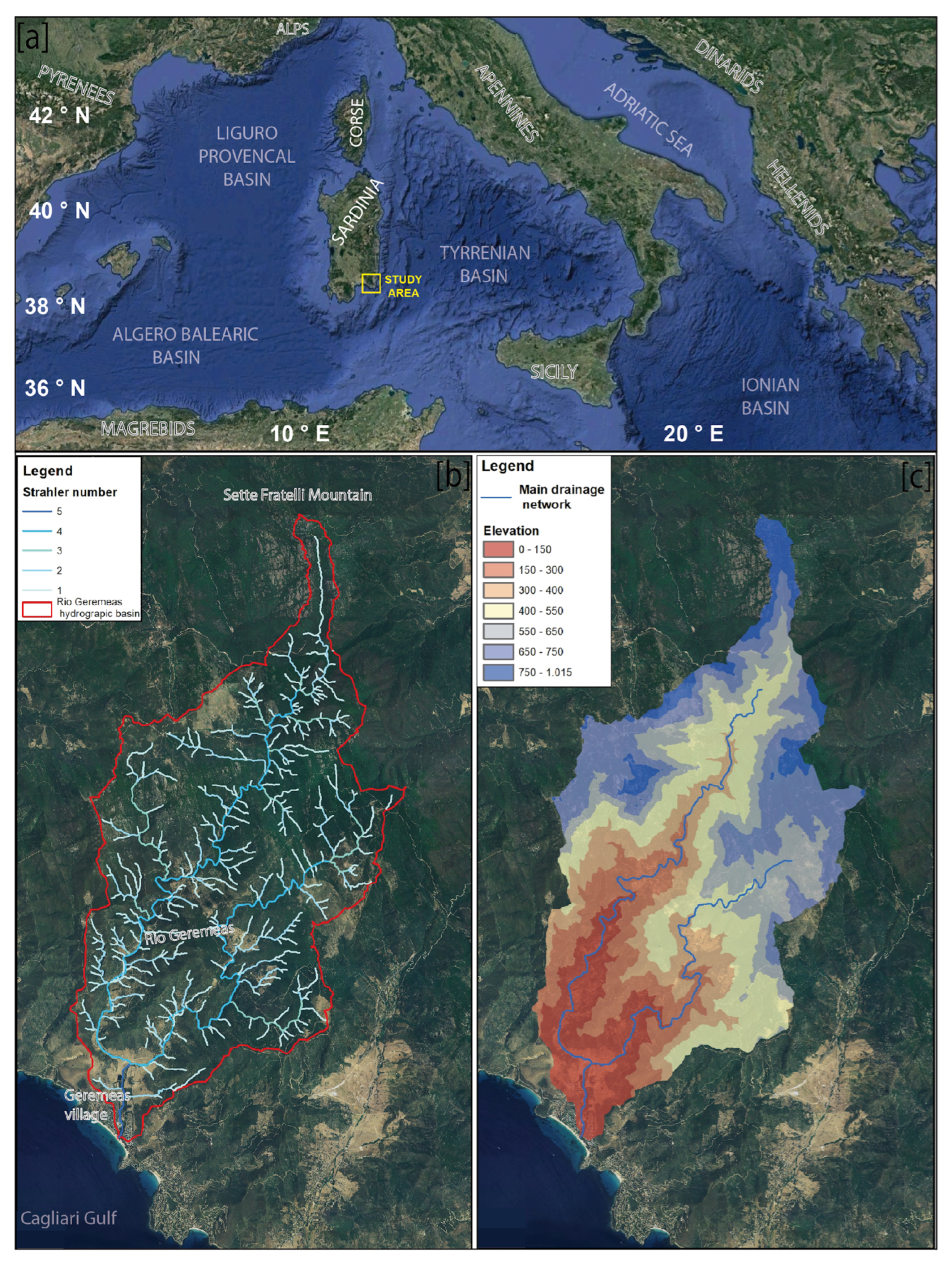
This study describes the application of the proposed integrated approach to the TB of Rio Geremeas, located in south-eastern Sardinia (Figure 1).
The Rio Geremeas is a TB with an event-driven hydromorphological response, representing TB in the Mediterranean area. It exhibits a complete morphological continuum from the mountainous headwaters to the coastal plain, allowing for an integrated analysis of sediment production, transport, and accumulation along different reaches of the drainage network. The high hillslope–channel–coast connectivity and the presence of typical anthropogenic pressures make it a transferable and methodologically relevant case study for sediment and hydrogeomorphological risk management at TB scale. Previous studies have highlighted that, during extreme rainfall events, the basin is capable of generating large volumes of mobilized sediment, which are rapidly transferred to the main channel and further to the coastal sector, potentially triggering cascading effects on the marine environment as well [21,22].
Overall, the study proposes an integrated and replicable approach for the development of sediment management plans in Mediterranean TB, providing operational support for management decisions aimed at hydrogeological risk mitigation, sustainable channel maintenance, and the improvement in the morphological and ecological status of watercourses [4,5,6].
The integrated geomorphological and ecological analysis, supported by hydraulic and morphodynamic simulations, The proposed integrated approach is applied to Geremeas TB in a two-step application procedure, baseline (current conditions) and design (project) steps, allowing the assessment of the effectiveness of different intervention configurations. These include both structural measures (e.g., flow regulation works and retention structures) and non-structural measures (such as channel maintenance, river restoration, and the restoration of sediment continuity), in accordance with the principles of the Water Framework Directive (2000/60/EC).

2. Study Area

The Rio Geremeas catchment is located in south-eastern Sardinia and its drainage network develops along a north–south direction, draining the waters of the southern sector of the Sarrabus massif and discharging into the Tyrrhenian Sea near the Geremeas tourist area.
The climate of the study area is typically Mediterranean, with strong seasonality characterized by hot, dry summers and relatively mild winters. From a bioclimatic perspective the area can be classified within the Mediterranean pluviseasonal oceanic macrobioclimate, with a continentality class ranging from strongly euoceanic to weakly euoceanic across most of the basin (Table 1). Within the Rio Geremeas catchment, moving from the coastal zone towards the mountainous sectors, a succession can be observed from the upper mesomediterranean thermotype to the lower thermomediterranean thermotype. Overall, four thermotypic horizons and four ombrothermic horizons (ranging from lower dry to upper sub-humid) can be identified, resulting in a total of 11 isobioclimates occurring within the study area.
The drainage area of the basin is 61 km2, and elevation ranges from 0 m a.s.l. at the river mouth to 951 m a.s.l., with a mean elevation of 451.07 m a.s.l (Table 2). The basin is drained by a well-defined fluvial network exhibiting an intermittent flow regime. Climatic conditions are typically Mediterranean, with air temperatures ranging from a minimum of 0 °C (January) to a maximum of 39.9 °C (August). Mean annual precipitation for the period 2019–2023 was 504.28 mm at the meteorological station (39°13′17.90″ N, 9°24′13.93″ E).
The hydrological regime is characterized by pronounced flow fluctuations, marked longitudinal discharge irregularity, and the absence of continuous flow along much of the drainage network during summer and autumn.
The area is characterized by a high diversity of geomorphological environments and a marked structural complexity, making it particularly suitable for integrated analyses of fluvial dynamics and erosional processes. The watercourse discharges into the Gulf of Cagliari, supplying sediments to a continental margin characterized by active, deep submarine canyons [22].
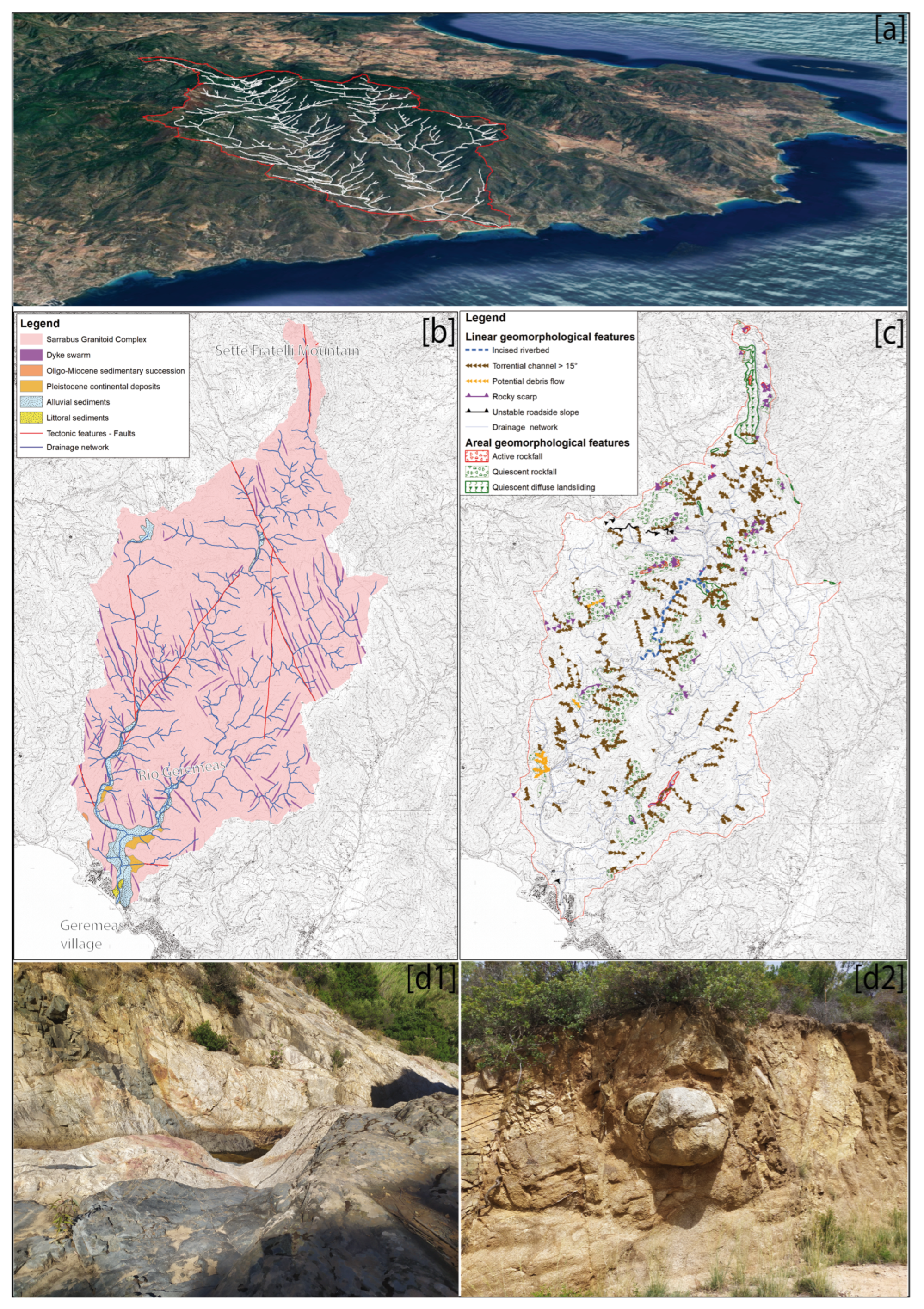
The basin can be subdivided into three main morphological and functional zones—the mountainous sector, the piedmont and alluvial plain sector, and the coastal–mouth sector—each characterized by specific geomorphological settings, hydrological regimes, and ecosystem types. This subdivision into three morphological and functional units provides a useful interpretative framework for understanding the relationships between geomorphological dynamics, hydrological connectivity, and ecological patterns within the Rio Geremeas fluvial system (Figure 2).
The mountainous sector corresponds to the high-elevation reaches developed on the granites of the Sarrabus massif, where steep slopes, widespread fracturing, and the presence of hillslope deposits promote gravitational processes and high-energy torrent dynamics. Despite the strong seasonality of runoff, this area still preserves relatively natural riparian vegetation, with hygrophilous formations and faunal species adapted to intermittent flow conditions.
The piedmont and alluvial plain sector represents the transition zone between the granitic uplands and the coastal plain. Here, the watercourse assumes a semi-confined character, with wider channels and valley bottoms largely occupied by agricultural activities. Reduced water availability and increasing anthropogenic pressure lead to a progressive degradation of riparian communities and the spread of invasive alien species, while hydrological discontinuity limits the establishment of stable fish assemblages.
The coastal and river-mouth sector constitutes the only reach with perennial flow and is influenced by natural processes of outlet channel closure and the resulting anoxic conditions. In this context, gallery riparian vegetation and transitional habitats develop, occasionally hosting euryhaline fish species during periods of connection with the sea. However, mouth closure and longitudinal fragmentation of the river system impair ecological continuity, particularly for migratory species such as the European eel (Anguilla anguilla L., 1758).
The catchment develops within the late-Variscan Sàrrabus magmatic complex, dominated by intensely fractured granitic and granodioritic lithologies intruded by widespread dike systems. The structural framework, controlled by fault systems and Plio-Quaternary tectonic uplift, dictates the drainage network orientation (NE–SW and NW–SE) and gives rise to deeply incised valleys [23,24,25]. Pervasive bedrock fracturing combined with intense precipitation events renders steep hillslopes highly susceptible to shallow landslides and debris flows. Quaternary alluvial and terraced deposits are concentrated along valley bottoms and the coastal zone, frequently remobilized by high-energy flood events. The catchment comprises four main physiographic units (planation paleosurfaces, incised hillslopes, piedmont alluvial plain, and coastal plain) and exhibits active fluvial morphodynamics.
The ecological structure of the Rio Geremeas catchment closely mirrors its longitudinal morphological gradient and the lithological–structural complexity that governs hydrological and sedimentary dynamics. The loss of ecological continuity, habitat fragmentation, and degradation of hydromorphological quality are concentrated in the piedmont and coastal sectors, where priority actions should focus on restoring longitudinal and lateral connectivity of the fluvial system and on the active management of the river mouth, in order to enhance hydrological exchange and facilitate the migration of fish species of conservation interest.

3. Materials and Methods

The study adopts an integrated methodological approach that combines field surveys, GIS analyses, and two-dimensional numerical modelling, in accordance with the guidelines of the IDRAIM protocol [26] for morphological monitoring of watercourses. The analysis was structured to provide a multi-scale interpretation of hydro-geomorphological processes and a spatially explicit assessment of sediment production, transfer, and accumulation within the Rio Geremeas catchment.
Geomorphological analysis integrated field surveys with high-resolution digital elevation models (1–10 m), enabling the mapping of morphological units, sediment sources, and major natural and anthropogenic discontinuities. Channel morphological classification and morphological quality assessment were carried out following the IDRAIM protocol, through the application of the Morphological Quality Index (MQI), adapted to the specific lithological and morphological characteristics of the basin.
Numerical modelling was developed using the MIKE 21C 2023 software, which was employed to simulate ordinary and extreme flood scenarios, including the morphological module to analyze channel response in terms of sediment erosion, transport, and deposition.
The integration of the different analytical components made it possible to reconstruct the morphodynamic functioning of the fluvial system and to assess the effectiveness of potential management measures, providing operational support for hydrogeological risk mitigation and sustainable basin planning.
The adopted approach combines:
-
a Mediterranean torrent context, typical of Sardinian basins, where sediment mobility is limited and strongly influenced by high-intensity events;
-
an integrated eco–geo–hydraulic analysis, bringing together ecological aspects (vegetation structure and physiognomy, fish communities, fluvial biodiversity), geomorphological aspects (sediment mobility, channel form, transport dynamics), and hydraulic/morphodynamic components;
-
a detailed description of the current state of the basin, from sediment source areas to depositional zones, based on surveys, morphological classifications, and modelling activities;
-
a methodology for selecting design configurations, including an evaluation of their effectiveness at the basin scale, considering both structural measures (e.g., check dams and flow regulation works) and management measures (e.g., channel maintenance, river re-naturalization, and restoration of sediment connectivity).
This integrated methodological framework enables the generation of robust intervention scenarios, grounded in scientific evidence and calibrated to the specific physical and environmental context of the Rio Geremeas catchment, and supports management decisions aimed at risk mitigation, sustainable maintenance, and the long-term conservation of the fluvial system.

3.1. Data

For the implementation of the geomorphological analyses and numerical modelling, several datasets were used, as summarized in the following table (Table 3).

3.2. Geomorphological Analysis

The geomorphological analysis of the Rio Geremeas catchment was carried out using a multi-scale and integrated approach, aimed at coherently describing sediment production, transfer, and accumulation processes along the hillslope–channel–coastal plain continuum. The approach involved the combined use of satellite imagery, high-resolution orthophotos, digital terrain models (DTM and DSM with resolutions of up to 1 m), and targeted field surveys, in line with the most recent geomorphological analysis methodologies applied to mountainous and torrent-type basins.
Sediment source areas were identified based on the recognition of active or potentially activatable geomorphological processes, including rockfalls, shallow landslides, debris flows, and diffuse and concentrated erosion. These processes were classified according to genetic type, activity state, and potential sediment contribution, following criteria well established in the literature and adopted within regional geomorphological analysis protocols.
Survey results were synthesized in a thematic geomorphological map produced in a GIS environment at a 1:10,000 mapping scale. Geomorphological features were manually digitized through photo-interpretation and field validation and organized according to the official ADIS legend (2022), integrating morphological, process-based, and depositional information. To support spatial analysis, morphometric processing (slope, curvature, contributing area) was also performed to refine the delineation of sediment source areas and sectors with higher susceptibility to instability.
Morphological analysis of fluvial channels focused on the characterization of the main reaches through three key indicators: degree of confinement, morphological type, and morphological quality. The degree of confinement was defined based on the extent of floodplains and the presence of direct contacts between the channel, hillslopes, or terraces, following the conceptual framework proposed by Brierley and Fryirs (2005) [29]. Fluvial morphology was classified into established channel types (step–pool, cascade, riffle–pool, glide, wandering) through the integration of direct field surveys and systematic photo-interpretation of river reaches. Channel morphological quality was assessed using the Morphological Quality Index (MQI), in accordance with the IDRAIM methodological framework.

3.3. Ecological Analysis

The ecological assessment of the Rio Geremeas basin was conducted in parallel with the hydro-geomorphological analysis and followed the subdivision of the river corridor into homogeneous reaches defined according to the IDRAIM framework. The study integrated analyses of riparian vegetation, landscape conservation, habitat quality, and faunal communities in order to evaluate ecological conditions along the longitudinal gradient of the catchment.
Riparian vegetation was investigated through a combined physiognomic and floristic approach within the bankfull channel and adjacent floodplain. Vegetation mapping was performed using high-resolution orthophotos and GIS-based photo-interpretation, followed by field verification. Homogeneous vegetation polygons were delineated and classified according to dominant physiognomy and species composition. To improve interpretation, ancillary information on channel morphology, substrate characteristics, and land use was also considered. Field surveys were subsequently carried out to validate vegetation boundaries and characterize floristic composition, vegetation structure, and dominant species. Sampling locations were selected through a targeted non-probabilistic approach based on the preliminary photo-interpretation phase and available environmental information [30]. The resulting map included both natural and semi-natural vegetation types as well as agricultural and artificial land-cover classes.
The vegetation units were organized within a hierarchical classification system and subsequently used to assess landscape conservation. The conservation status of the river corridor was evaluated through the Index of Landscape Conservation (ILC), originally proposed by Pizzolotto and Brandmayr [31] and subsequently applied and adapted in several ecological studies [32,33,34]. The index quantifies landscape naturalness based on the cumulative percentage of the area occupied by vegetation and land-use classes ranked along a gradient of increasing naturalness, defined by their distance from the structurally most stable vegetation type under the specific climatic and geopedological conditions of the area [35]. The adopted naturalness categories and the corresponding vegetation types are reported in the Supplementary Material.
The faunal component was assessed through targeted field surveys focusing on representative taxa occurring along the longitudinal gradient of the basin. Monitoring activities included visual censuses of the Sardinian brook newt (Euproctus platycephalus) in headwater habitats and surveys of fish communities in the lower reach and river-mouth area. Particular attention was devoted to the occurrence of the European eel (Anguilla anguilla), including monitoring of juvenile recruitment through floating traps. To assess habitat suitability and hydrological connectivity, water quality parameters including dissolved oxygen, salinity, temperature, and pH were measured at several stations along the terminal sector of the river.
For plant taxonomy, nomenclature follows the updated Checklist of the Vascular Flora of Italy [36].

3.4. Hydromorphological Analysis

For the modelling component, the MIKE 21C model was implemented. Accounting for secondary flow process proved to be particularly relevant in the Rio Geremeas, where helical flow significantly influences the behavior of transported sediment in river bends. The simulations were made for different boundary conditions, at different return periods, both in presence and absence of a preceding ordinary flow event.
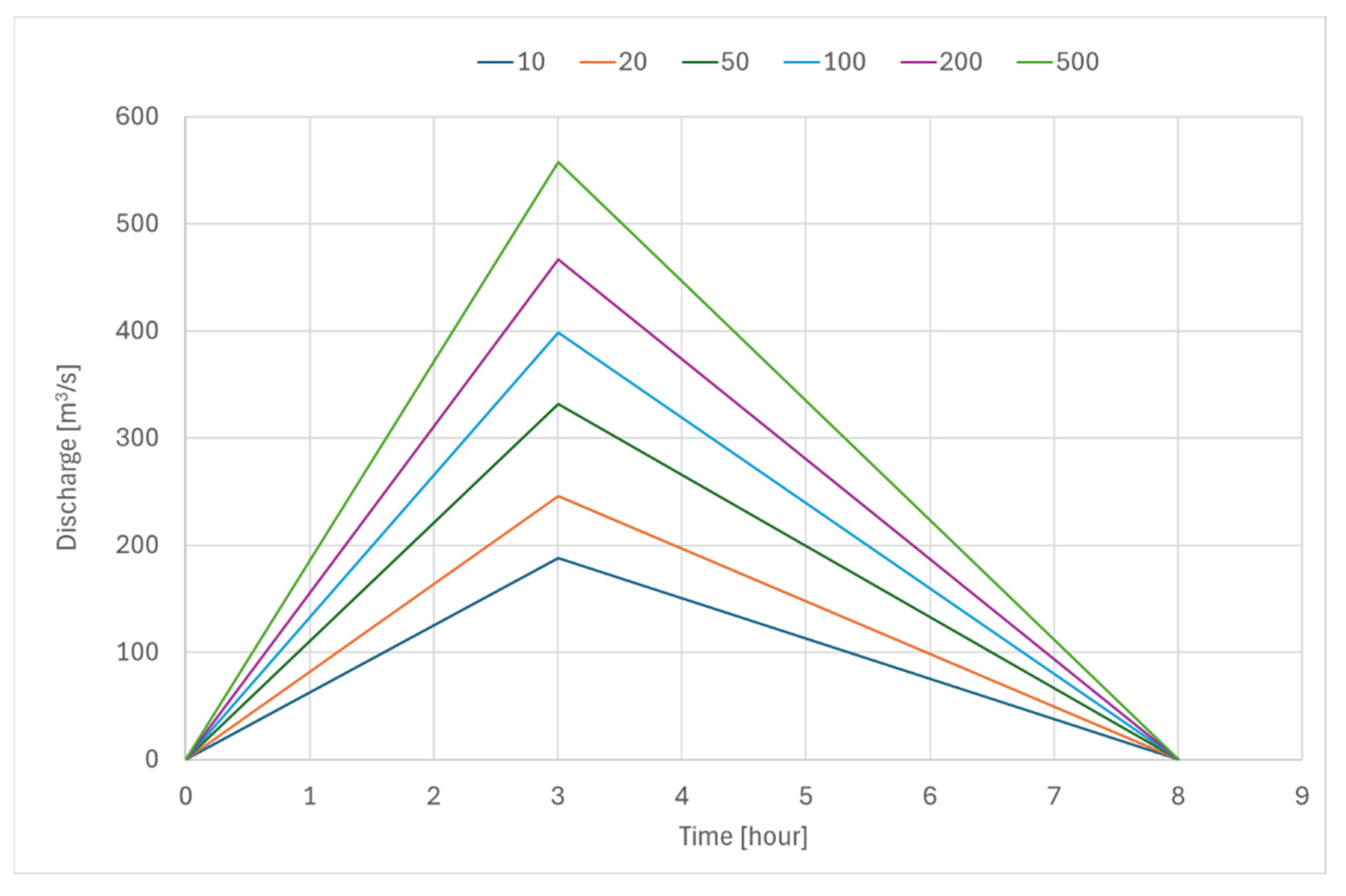
The flood event is represented by a triangular-shaped hydrograph, defined by the peak discharge, the duration of the concentration phase, and the flood volume (Floodplain Zoning Plan—PSFF) (Figure 3). The methodology used to estimate the peak discharge is indirect and is based on the regionalized TCEV probabilistic distribution. Rainfall data are used to estimate the total flood volume through the calculation of effective rainfall volume.
As a precautionary approach, these flood discharges were adopted as reference values for the hydraulic design of the entire river length.
We adopted as a lowest boundary condition, a sea level in the estuary at +1.80 m above mean sea level, regardless of the return period of the simulated event and properties of the sea storm.
Additional aspects of sediment transport modelling, which are essential for reproducing the complex sediment distribution observed in the Rio Geremeas and described in the previous sections, are related to the definition of up to 16 sediment fractions, including both cohesive and non-cohesive sediments, and to the use of a bed layering model that allows the riverbed to be represented by 0–16 layers, dynamically updated together with bed topography in a continuous manner.
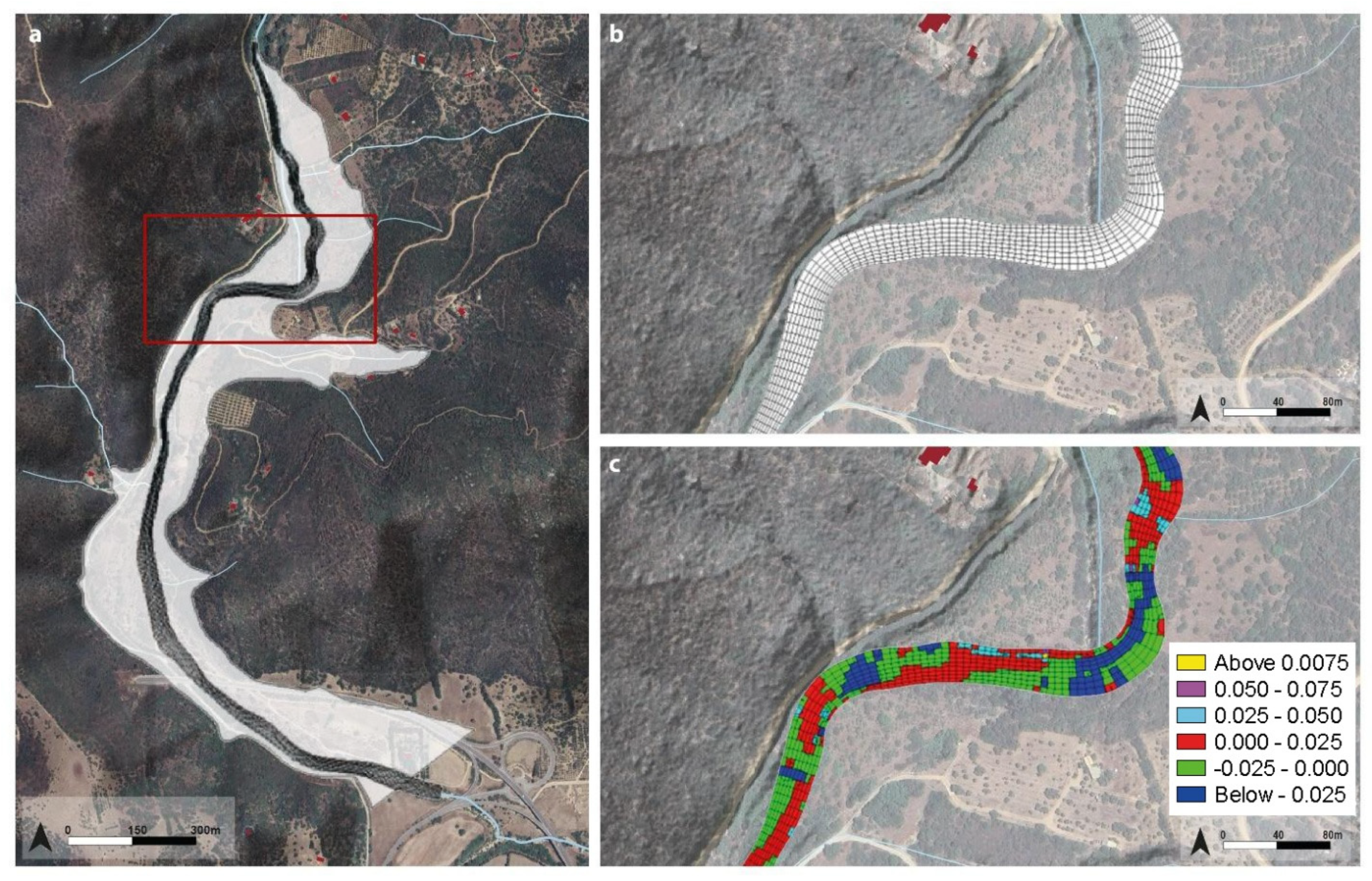
To define the current hydraulic behavior of the river course, roughness values varying only between the active channel and the floodplain were adopted and assumed to be constant along the entire river reach (Figure 4). The Manning flow resistance coefficient (M = 1/n) was set equal to 10 m1/3 s−1 for the active channel and 20 m1/3 s−1 for the floodplains. Finally, in the modelling of the design scenario, the coefficient M was set to 95 m1/3 s−1 in the reshaped reaches and in the diversion channel.
The model, which is strongly integrated in its hydraulic, sedimentary, geomorphological, and ecological components, requires the definition of a set of input parameters and spatial datasets. In particular, a detailed activity focused on geomorphological characteristics and sediment dynamics, including the representation of the complex channel-bed stratigraphy (Figure 5).
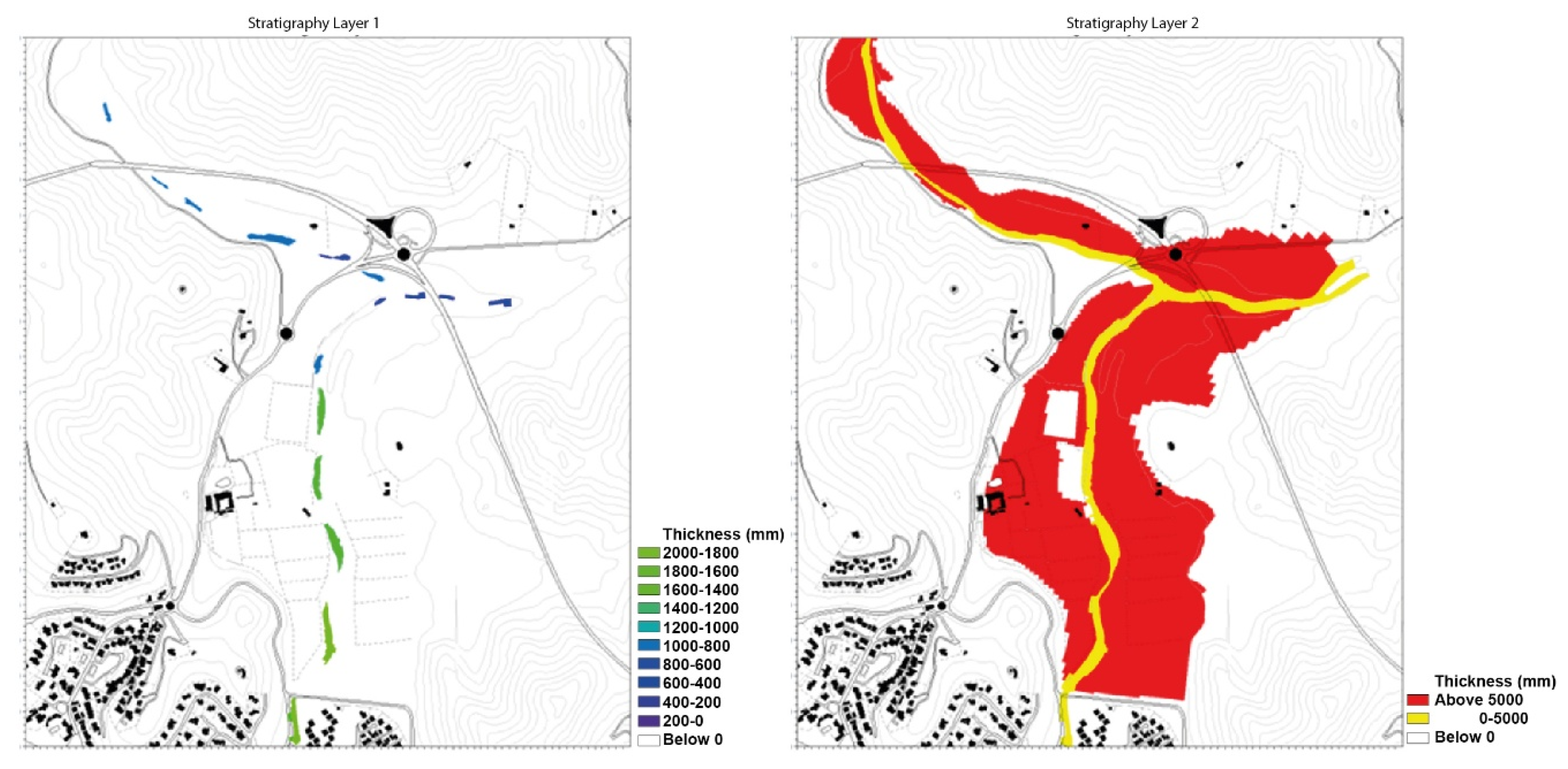
Stratigraphy is defined as a superposition of layers, with a single grain-size distribution curve assigned to each layer. In the upper part of Figure 6, a stratigraphy composed of three layers is shown, each initially represented by the same grain-size distribution. The model output provides results such as those illustrated in the lower part of the figure, where each cell within each layer is associated with a new grain-size distribution, resulting from the morphodynamic computations.

3.5. Stratigraphy and Sedimentological Data

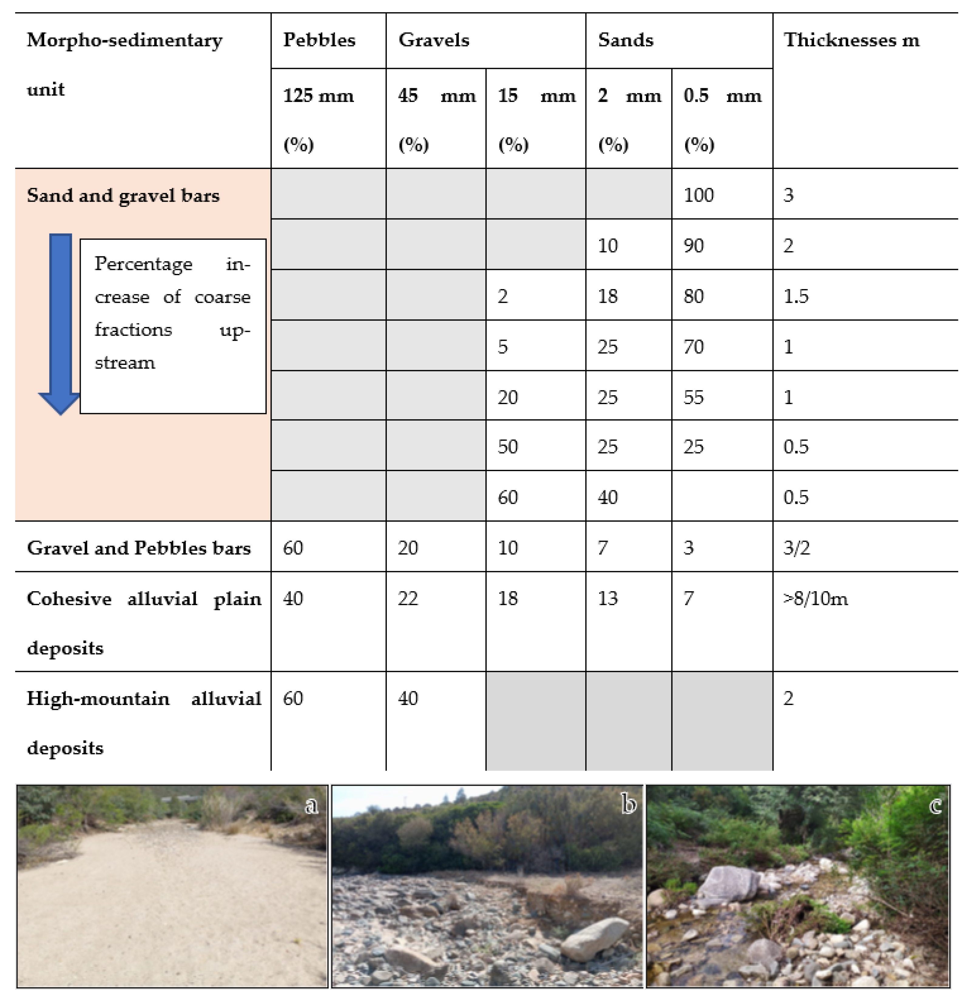
The characterization of sedimentary bodies was carried out through the definition of morphosedimentary units. Depositional landforms along the watercourse were mapped, and a sedimentological characterization was performed for each. Fine sediments (<2 cm) were analyzed via sampling and laboratory grain-size analysis, whereas coarse sediments (>2 cm) were characterized using in situ photographic acquisition and image analysis. Figure 6 summarizes the characteristic grain-size data of the morphosedimentary units used for the hydromorphological model.
The sediment and geomorphological survey revealed a marked heterogeneity in sediment distribution along the Rio Geremeas. Five distinctive sedimentary units were identified within the catchment:
I.
high-mountain alluvial deposits;
II.
bedrock channel;
III.
sand and gravel bars;
IV.
gravel and cobble bars;
V.
alluvial plain.
From a grain-size perspective, the samples exhibit high heterogeneity due to the complex fluvial dynamics responsible for their deposition, with gravel and cobble deposits being predominant. Conversely, sand is present within local sand and gravel bars that are unevenly distributed along the entire watercourse. Silt is found in all samples, albeit in extremely limited quantities. From a mineralogical–petrographic standpoint, the nature of the clasts reflects the basin’s lithology, showing an abundance of granitoids and, to a lesser extent, cobbles and gravels from basic vein intrusions.
Stratigraphy was modelled using two layers, representing depths in millimetres (Figure 6). The lower layer includes three sedimentary units (high-mountain alluvial deposits, not visible in the figure; gravel and cobble bars shown in yellow; and the alluvial lain shown in red), while the upper layer includes sand and gravel bars. The three substrate units of the lower layer (Layer 2) were modelled using a single uniform grain-size distribution for each sedimentary unit, spatially distributed uniformly across the entire area of interest. For the surface layer (Layer 1), a spatial variation in grain-size distributions was introduced to reflect the downstream decrease in the proportion of coarse fractions.
Figure 6. Stratigraphic layers implemented in the MIKE 21C morphodynamic model for the Rio Geremeas study reach. Left: Layer 1; right: Layer 2.
Climate 14 00182 g006
The modelling framework also accounted for the non-erodibility of the reshaped channel and the right-bank diversion structure, using layers analogous to those defined for the present-state configuration. Regarding sediment transport formulations, the Wilcock and Crowe equation was selected to estimate potential bed load transport, while the Ackers and White formulation was adopted for suspended sediment transport. The Wilcock and Crowe formulation is particularly suitable for beds composed of gravels and sands. Although the Ackers and White formulation may overestimate suspended sediment transport for grain sizes finer than 0.2 mm [37], it was considered appropriate in this study because the sediments present do not fall within this size range, thereby avoiding the risk of overestimation.

4. Results

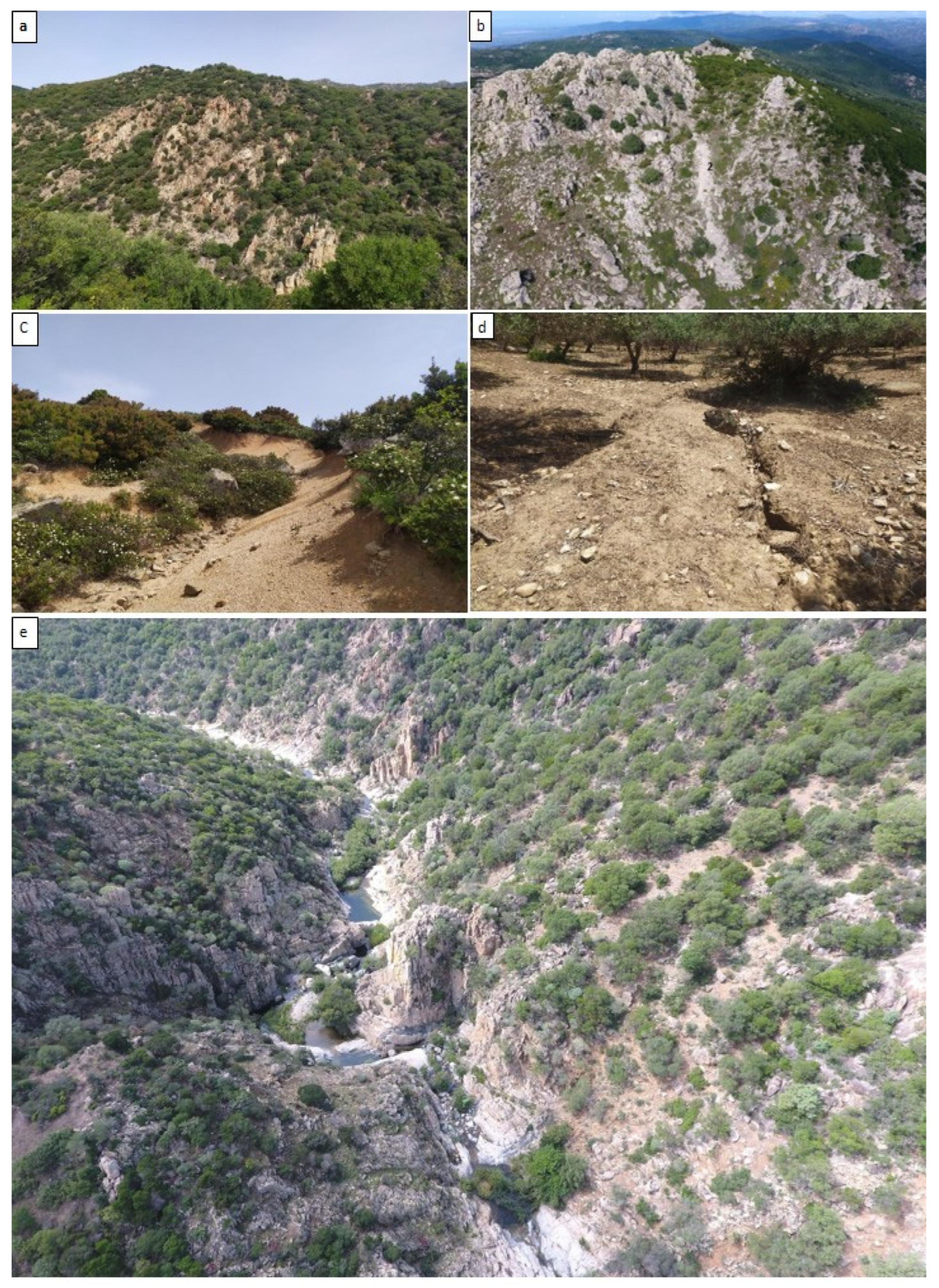
The results obtained from the integrated analysis of the Rio Geremeas catchment are structured into three main components: (i) sediment production and transport from hillslopes and the morphological characterization of the fluvial channel (Figure 7); (ii) ecological characterization; and (iii) hydraulic and morphodynamic modelling of system behavior under flood scenarios. These analyses provide a detailed understanding of the active geomorphological and hydraulic dynamics, as well as of the critical issues and potentialities in terms of risk management and intervention planning.

4.1. Geomorphological Characterization and Sediment Dynamics

Sediment supply in the Rio Geremeas catchment is dominated by gravitational processes acting on steep, deeply fractured granitic slopes (rockfalls, shallow landslides, and debris flows). Driven by intense rainfall events, these slope instabilities produce predominantly coarse material (blocks and cobbles) with poor grain-size sorting. Deeply incised hillslopes directly connected to the drainage network rapidly transfer sediment from low-order streams to the main channel. Sediment inputs occur as episodic yet substantial pulses that strongly control in-channel transport and storage dynamics. Consequently, the river channel alternates between confined reaches serving primarily as transfer zones and lower-gradient sectors favoring temporary accumulation of hillslope-derived material.
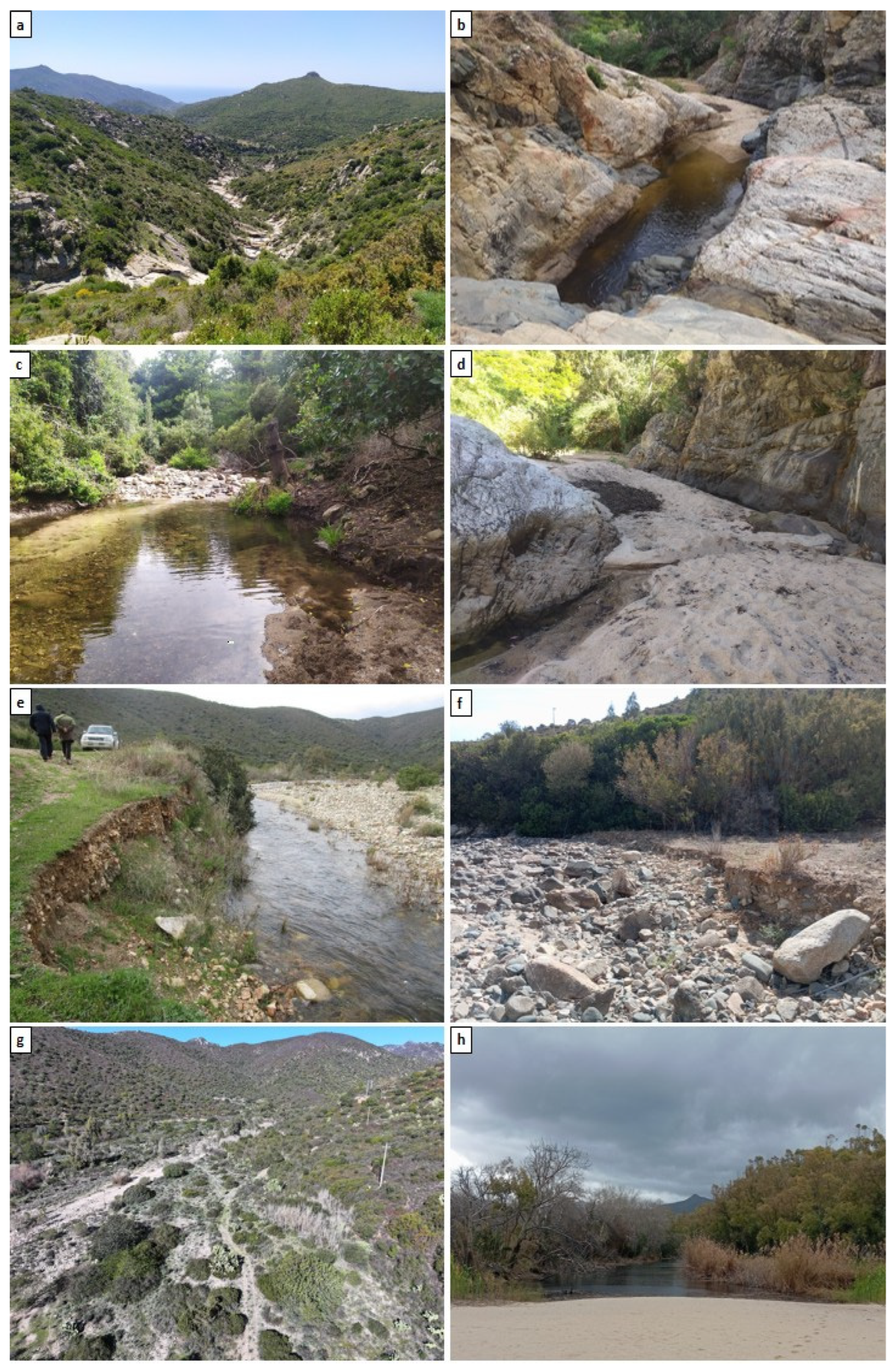
The longitudinal morphological analysis of the river channel reveals a pronounced differentiation of fluvial patterns across the main physiographic units of the Rio Geremeas catchment, driven by structural control of the substrate, slope variability, and the downstream energy gradient (Figure 8).
In the upper reaches, developed mainly on compact and intensely fractured granitic lithologies, the channel is strongly confined and incised into bedrock, exhibiting step–pool and cascade morphologies that reflect an equilibrium dominated by vertical erosional processes and episodic sediment transport. In these sectors, the channel primarily acts as a sediment transfer zone, with limited capacity for stable storage of coarse hillslope-derived material.
Downstream, within the intermediate and piedmont reaches, a progressive weakening of structural control and a reduction in longitudinal slope promote the transition toward mobile-bed channels. Here, the channel displays increased morphological complexity, with the development of alternate bars, riffle–pool sequences, and temporary depositional forms, organized according to a spatial hierarchy controlled by channel width, valley confinement, and coarse sediment availability. During flood events, these reaches represent key zones of morphosedimentary reorganization, where sediment pulses supplied from hillslopes and tributary hollows may be temporarily stored or rapidly redistributed along the main channel.
A significant role is played by rapid mass-flow processes (debris flows and debris floods), which primarily affect mountainous tributaries and transition zones between the upper and piedmont sectors. These events deliver abrupt inputs of coarse sediment to the main channel, locally modifying channel geometry and triggering aggradational phases followed by subsequent episodes of incision or lateral adjustment. This pulse–relaxation dynamic is consistent with the Mediterranean torrent character of the basin, which is strongly controlled by climatic variability and the concentration of intense rainfall events.
In the lower and coastal reaches, the further reduction in slope and widening of the valley floor favor fluvial patterns with higher lateral mobility, including sinuous and wandering channels, the presence of mid-channel islands, and multiple bar systems. The geomorphological configuration of the coastal plain reflects the interaction between fluvial dynamics, sediment supply, and coastal processes, resulting in alternating phases of sediment accumulation and redistribution. In this context, the coastal barrier–dune–lagoon system acts as a final sediment filter and storage zone, regulating the dispersal of both fine and coarse materials toward the nearshore marine environment.
During exceptional flood events, high suspended sediment concentrations may promote the onset of hyperpycnal flows at the river mouth, leading to the direct transfer of material to the marine environment and its potential propagation across the inner continental shelf. This land–sea connectivity represents a key element for understanding the overall sediment budget of the basin and for assessing impacts at the coastal scale.
The comparison between historical surveys and the current morphological configuration highlights a tendency toward channel incision in some piedmont reaches, which can be attributed to a reduction in effective sediment supply associated with sediment disconnections, anthropogenic interventions, and alterations in longitudinal continuity. In contrast, other sectors exhibit enhanced lateral mobility and the development of transient morphological forms in response to recent flood events.
This spatial and temporal variability in channel configuration is critical for interpreting the fluvial system response to changes in the sediment budget and represents a key prerequisite for defining management and intervention strategies that are consistent with the natural dynamics of the catchment.
Sediments within the Rio Geremeas catchment were classified into three main depositional types: (i) terraced floodplain deposits, (ii) coarse channel deposits, and (iii) sandy bars.
Coarse deposits are characterized by a heterometric grain-size distribution, with an abundance of large angular blocks and cobbles embedded in a generally subordinate sandy or silty matrix. These deposits are poorly sorted and directly reflect the lithological and structural characteristics of the underlying granitic substrate.
Floodplain deposits and sandy bars exhibit a better-sorted grain-size distribution, primarily controlled by flow energy and local hydraulic conditions. Gravels and coarse sands dominate in valley-bottom reaches and higher-energy sectors, whereas a progressive enrichment in finer fractions (medium-to-fine sands and silty sands) is observed in lower-energy reaches, particularly within the coastal plain. Sandy bars represent transient depositional forms, subject to frequent remobilization during flood events, and play a key role in regulating local sediment transport dynamics.
Sedimentological analyses conducted on samples collected along the main channel reveal a clear longitudinal variation in grain-size distribution, consistent with the altitudinal and energy gradient of the river system. Mountainous and piedmont reaches retain a high proportion of coarse material, associated with high flow competence during flood events, whereas downstream reaches show a progressive fining of sediments, driven by decreasing channel slope and an increasing frequency of depositional conditions.
These sedimentological data provided the basis for the parameterization of the morphodynamic module of the MIKE 21C model, enabling a more realistic representation of sediment transport, erosion, and deposition processes along the river course and allowing the assessment of channel morphological responses to different mobilizable grain-size classes.

4.2. Hydromorphological Model

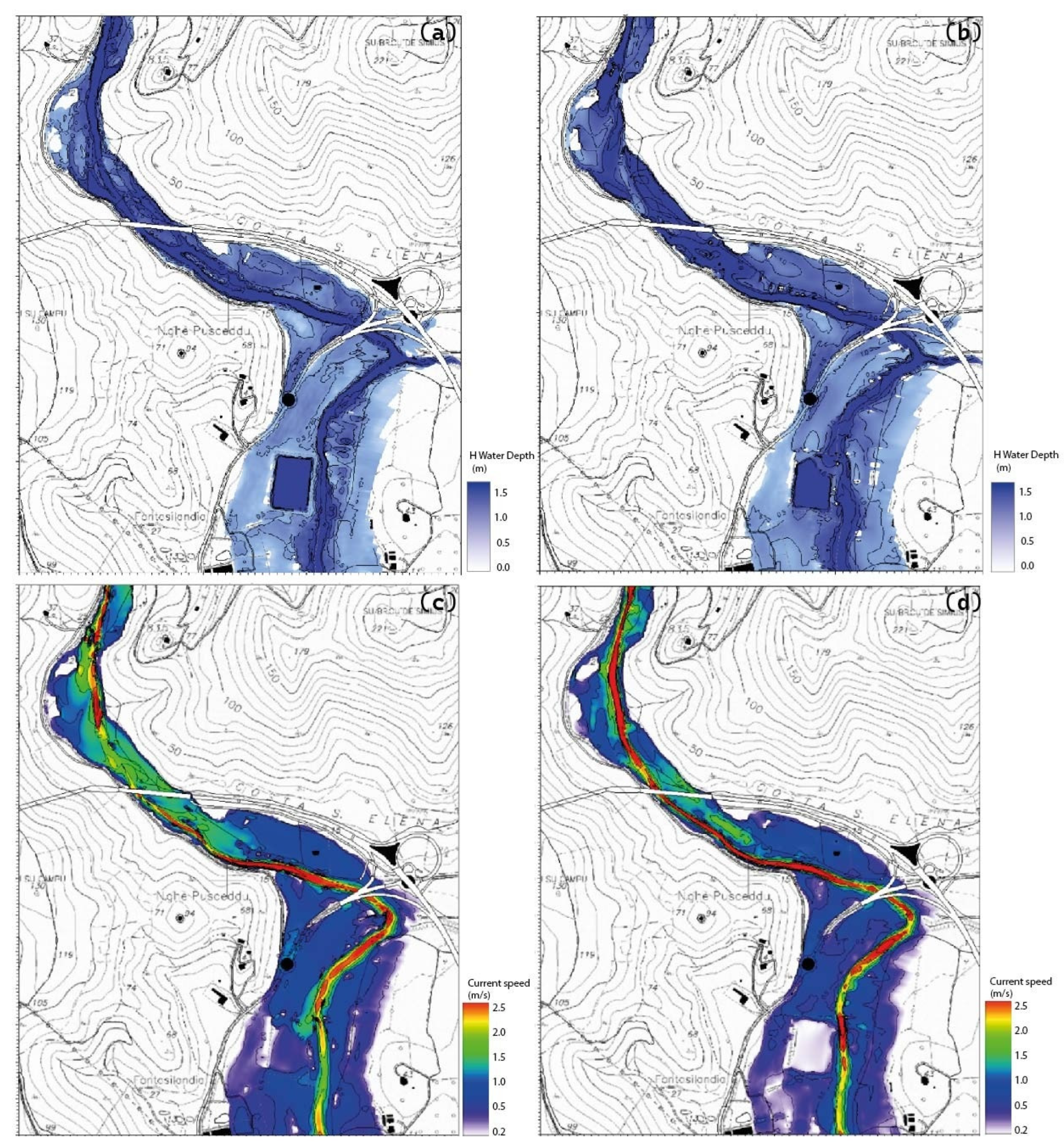
The MIKE 21C model enabled high spatial and temporal resolution simulations of the hydraulic and morphodynamic dynamics of the Rio Geremeas under 50-year return period flood conditions. The simulations included scenarios both with and without a preceding ordinary event, highlighting the fundamental role of morphological pre-conditioning in controlling system behaviour. Results show peak flow velocities exceeding 2.5 m s−1 in semi-confined and unconfined reaches, associated with significant localized erosion and downstream deposition processes.
Preliminary simulations focused on defining the morphological equilibrium condition of the unconfined channel. Extreme-event simulations with the assigned return period were subsequently performed with respect to this reference condition. The results indicate that the spatial patterns of morphological evolution—namely erosion and deposition zones—are persistent and primarily governed by the extreme flood event, whereas the magnitude of sediment transport varies significantly among scenarios. Analyses carried out within this study suggest that a 24 h simulation with a constant discharge corresponding to a 2-year return period is sufficient to approximate a morphological equilibrium condition for the main channel of the Rio Geremeas.
The following figures refer to a 50-year return period event, simulated under both purely hydraulic and coupled hydro-morphodynamic modelling configurations.
The figures illustrate flooded areas for two river reaches: a semi-confined reach and an unconfined, river-mouth reach. From a qualitative perspective, the inundation extents appear largely comparable between the two modelling approaches, whereas water depths and flow velocities are significantly influenced by the morphological evolution captured only in the coupled model. In particular, the coupled hydro-morphodynamic simulations yield greater water depths in these reaches compared to the purely hydraulic model (Figure 9).
As expected, flow velocity in the purely hydraulic model is higher than in the coupled hydro-morphodynamic model, in which the flow is effectively attenuated by sediment transport. The comparison of flow velocities between the two scenarios, shown in Figure 9, highlights the damping effect exerted by transported sediment on flow celerity.

4.3. Ecological Model

The ecological characterization of the Rio Geremeas basin revealed a pronounced longitudinal gradient associated with both natural geomorphological controls and increasing anthropogenic pressure from the mountainous sector toward the coastal plain.
Vegetation surveys identified 24 physiognomic–floristic vegetation types and 9 land-use classes distributed across the three investigated river reaches. The confined mountainous reach retained the highest degree of naturalness, with approximately 97% of the area occupied by natural vegetation. Riparian forests dominated by Alnus glutinosa, woodlands of Quercus ilex, and shrub communities dominated by Nerium oleander constituted the most extensive habitats. These formations were associated with relatively stable channel segments and well-preserved riparian corridors.
In the intermediate semi-confined reach, riparian vegetation appeared fragmented and discontinuous. Native shrub formations were mainly represented by patches dominated by Tamarix africana, Nerium oleander, and Olea europaea, whereas extensive stands of Arundo donax occupied significant portions of the active channel and channel margins. The surrounding floodplain was largely characterized by agricultural land uses, including arable land, pastures, olive groves, and abandoned orchards, locally interspersed with thermo-Mediterranean maquis recolonizing formerly cultivated areas.
Ecological degradation was most evident within the coastal sector, where agricultural land occupied more than half of the floodplain and artificial surfaces accounted for approximately 27% of the total area. The riparian corridor was strongly reduced and largely dominated by alien species, particularly Arundo donax and Eucalyptus spp., whereas native riparian formations survived only as small and fragmented remnants. In the river-mouth area, tree stands dominated by Populus alba, Populus nigra, and locally Ulmus minor represented the last relatively continuous riparian habitats.
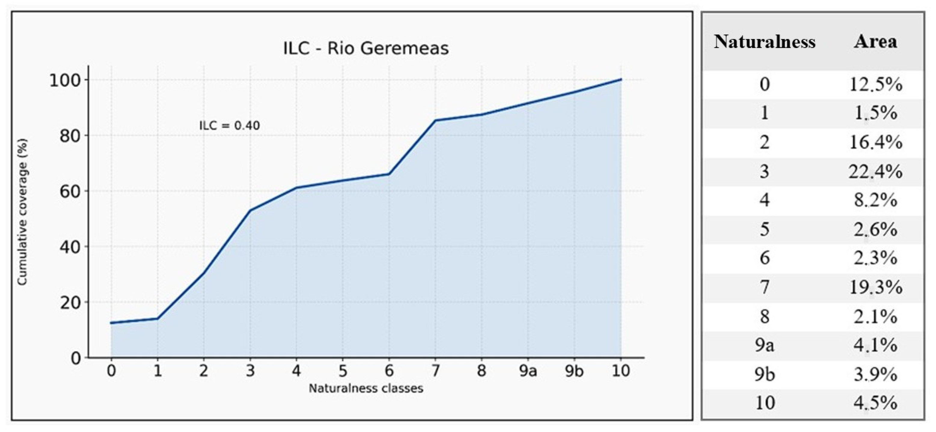
The Index of Landscape Conservation highlighted these spatial patterns (Figure 10). The overall basin value (ILC = 0.40) indicated an intermediate conservation status resulting from the coexistence of relatively extensive natural vegetation in the upper basin and increasing levels of land-use transformation downstream. At reach scale, the index showed a marked decline from the mountain sector (ILC = 0.90) to the piedmont sector (ILC = 0.44) and finally to the coastal plain (ILC = 0.27), reflecting the progressive replacement of natural habitats by agricultural areas, infrastructure, and vegetation dominated by alien species.
Physico-chemical monitoring highlighted critical environmental conditions in the lower basin, particularly in the river-mouth sector. Dissolved oxygen concentrations reached extremely low values (1.17 mg L−1), corresponding to approximately 11% oxygen saturation, while pH values were acidic (5.05). Salinity values indicated seawater intrusion favoured by the periodic closure of the river mouth and the consequent reduction in freshwater flushing. Suboptimal oxygen conditions were also recorded upstream, suggesting limited longitudinal hydrological connectivity during the low-flow season.
The observed physicochemical conditions were reflected in faunal distribution patterns. No stable fish assemblages were recorded throughout most of the basin, and fish occurrence was restricted to temporary colonization events in the estuarine reach during periods of connection with the sea. Visual observations of dead individuals of Mugil cephalus and Dicentrarchus labrax along the riverbanks suggested that recurrent mouth closure and rapid oxygen depletion frequently create unsuitable environmental conditions, effectively transforming the terminal reach into an ecological trap.
Monitoring of the reintroduced Sardinian brook newt (Euproctus platycephalus) documented a rapid decline in adult abundance, from 30 individuals recorded in 2019 to the absence of observable adults by 2020. Nevertheless, the detection of larvae confirmed successful reproduction prior to population contraction, indicating that recruitment remained possible despite the effects of prolonged summer drought and predation pressure.
Quantitative sampling of benthic macroinvertebrates was not pursued because environmental instability and intermittent flow conditions were considered unsuitable for supporting representative resident communities. Preliminary observations suggested the prevalence of temporary colonizers associated with episodic hydrological events rather than stable aquatic assemblages.
Overall, ecological patterns closely mirrored hydro-geomorphological conditions across the basin. The upper confined reaches, characterized by higher habitat naturalness and more continuous riparian vegetation, exhibited greater ecological functionality, whereas downstream sectors affected by habitat fragmentation, invasive species, agricultural intensification, and reduced longitudinal connectivity showed pronounced ecological degradation. The correspondence between geomorphological alteration, disruption of sediment dynamics, and ecological impairment supports the need for restoration actions aimed at improving ecological continuity, controlling invasive species, and enhancing riparian habitat functionality, particularly in the lower catchment and river-mouth sector.

4.4. Morphological Quality Index (MQI)

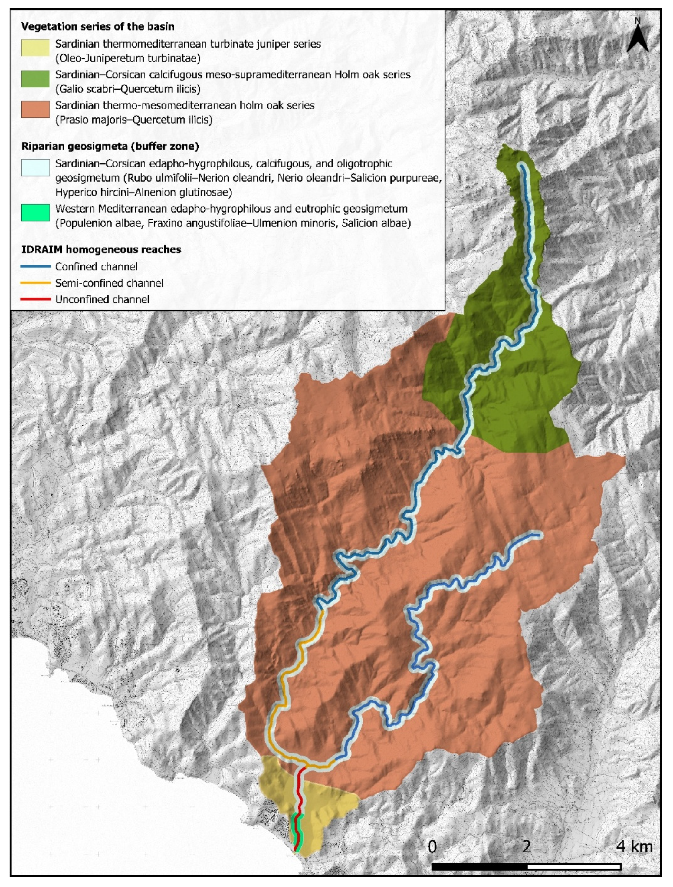
The hydromorphological status evaluation of the Geremeas River applies the IDRAIM guidelines to analyze the watercourse’s deviation from a natural reference condition (Figure 11). Through GIS data, remote sensing, and field surveys, the analysis integrates three main components: geomorphological functionality (analysis of current landforms and processes), the impact of artificial elements (anthropogenic structures), and historical morphological variations (last 50–60 years). The analysis highlights an overall positive hydromorphological picture for the Geremeas River (ranging from high to good).
  • High-Mountain and Granitic Hill Reaches (Confined)—Status: HIGH/EXCELLENT
    The watercourse consists of a single channel, constrained by the slopes for almost its entire length. It exhibits high ecological and geomorphological status. The only negative factors are represented by some earth and concrete fords that locally interfere with the river’s continuity.
  • Semi-confined Reaches—Status: GOOD
    These feature a single or multi-thread channel structure, constrained only locally by the slopes. The watercourse maintains a good ecological and geomorphological status; adverse factors are linked to the limited presence of riparian vegetation and the impact of some crossing structures.
  • Unconfined Reaches (from the S.S. 125 bridge to the mouth)—Status: GOOD
    The watercourse flows in a single channel, maintaining an overall good ecological and geomorphological status. Disruptive factors include low-impact crossing structures and various flood protection works, such as bank protection structures and hydraulic cross-section reshaping.

5. Discussion

The analysis carried out for the Rio Geremeas catchment represents a significant case study of the application of an integrated approach adapted from the IDRAIM system [26], which has already been successfully applied in several Italian basins characterized by similar morphoclimatic and lithological conditions, such as the Dittaino River in Sicily, the Orco Torrent in Piedmont, and the Gutturu Mannu catchment in south-western Sardinia. In these contexts, the integration of detailed geomorphological surveys, morphological quality assessment, ecological investigations, and numerical modelling has proven to be crucial for identifying critical reaches and defining intervention scenarios consistent with the objectives of the Water Framework Directive (2000/60/EC), as also highlighted by recent experiences in basin-scale integrated sediment planning [4,5].
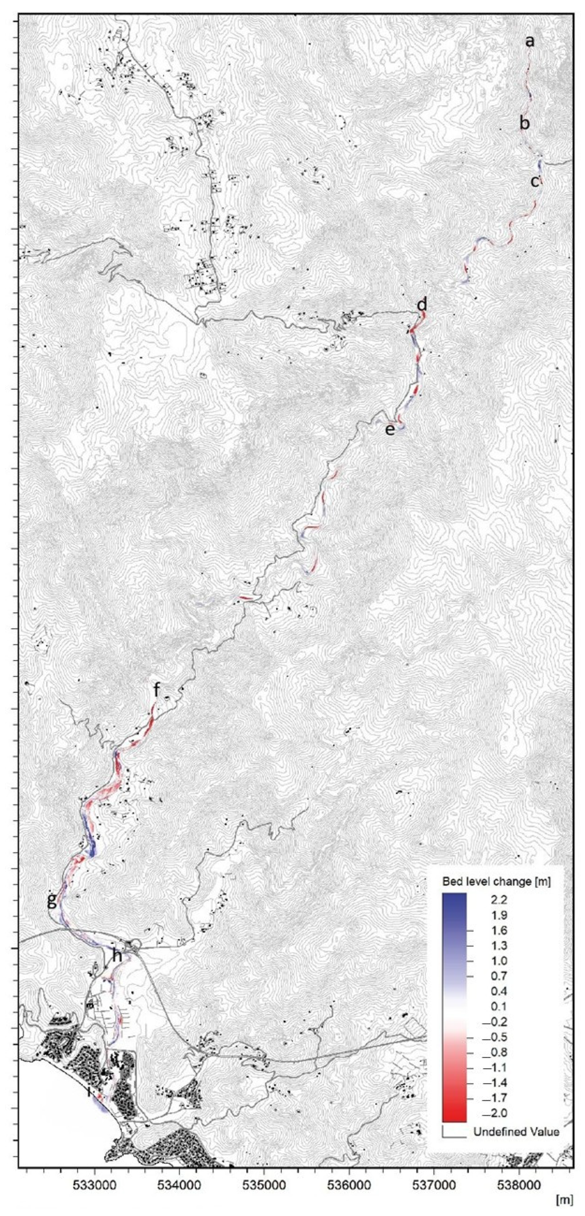
The geomorphological analysis integrated with hydromorphological assessment allowed the identification of homogeneous sectors in terms of morphosedimentary dynamics (Figure 12). In particular, within the confined reach (Reach a–f), the integrated analysis highlights dominant erosional processes, with the formation of high-mountain alluvial deposits, followed downstream by sandy–gravel depositional areas within a bedrock channel, interspersed with limited erosional zones in the steepest sections. In the semi-confined reach under structural control with angular planform, alternating channel-bed and bank erosion processes coexist with depositional dynamics.
The piedmont alluvial plain reach, characterized by a reduction in longitudinal slope, together with the coastal plain, exhibits a marked deceleration of flow, with mean velocities exceeding 2 m s−1 only within the active channel. In the coastal plain, the 50-year return period floodplain affects a large portion of the urban area, although with low water depths and flow velocities. A clear dominance of depositional processes upstream of Provincial Road SP 17 is observed, whereas downstream, within the reshaped channel, flow acceleration with mean velocities exceeding 3 m s−1 leads to a dominance of erosional processes extending to the beach system, resulting in the opening of breaches. The direct input of hyperpycnal flows into the submerged beach is clearly evident.
The combination of geological setting, inherited tectonic framework, and intense fracturing of the granitic substrate exerts a primary control on both the organization of the drainage network and hillslope instability processes. The widespread occurrence of strongly fractured late-Variscan granites, documented for the Sàrrabus massif [24,25], promotes a high production of coarse sediment through shallow landslides, debris flows, and dry ravel processes. This behavior is consistent with observations from other mountainous settings characterized by competent lithologies and pronounced structural discontinuities [38]. Such a framework is also in agreement with the results reported by Meleddu (2019) [21] for the Sàrrabus basins, highlighting the role of NE–SW structural lineaments in controlling morphogenesis and sediment transfer dynamics from inland areas to the coastal environment.
A strongly hierarchical distribution of sediment sources emerges, distinguishing mountainous sectors characterized by high sediment transfer efficiency toward the main drainage network from piedmont and valley reaches dominated by sediment storage processes. This configuration confirms that sediment connectivity within the Geremeas catchment is discontinuous and highly dependent on morphological thresholds, channel confinement, and anthropogenic interferences, in line with theoretical frameworks developed for mountainous and torrent-type basins [1,39]. Comparable patterns have been documented in European and Alpine catchments, where functional sediment connectivity is strongly modulated by high-magnitude events and upstream sediment availability [12,40].
The hydraulic and morphodynamic simulations performed using MIKE 21C provided essential quantitative support for interpreting the processes observed in the field, demonstrating the ability of coupled 2D models to reproduce realistic morphodynamic evolution scenarios in Mediterranean torrent environments. In particular, the results indicate that only flood events with medium-to-high return periods, when combined with high sediment availability, are capable of triggering significant redistribution of channel-bed material. These findings confirm observations from recent studies on Apennine and Alpine rivers [6,41]. The simulated effects of the proposed management interventions are consistent with experiences documented in the Dittaino catchment, where morphological reconfiguration and sediment management measures resulted in a reduction in flow velocities, bank erosion, and local hydraulic risk [19].
From a morphological perspective, the assessment of the Morphological Quality Index (MQI) revealed a significant loss of functionality in the most heavily artificialized reaches, particularly within semi-confined and unconfined sectors, where rigid channelization works have altered the natural channel dynamics. These results are consistent with observations from other Mediterranean and European contexts, where channel artificialization is associated with a reduced capacity for morphodynamic adjustment and an increased vulnerability to extreme events [41,42]. Within this framework, the restoration of morphodynamic freedom and the reallocation of lateral mobility space emerge as key strategies for sustainable risk management, in line with approaches based on morphodynamic corridors [19,41].
From a vegetation standpoint, analyses of the composition and extent of the riparian corridor and the application of the Landscape Conservation Index depict a situation comparable to that observed in most Mediterranean riparian environments, characterized by better-preserved riparian vegetation in mountainous sectors and more fragmented and simplified conditions in valley reaches [43,44]. Common critical issues typical of Mediterranean contexts, such as the reduction in riparian width and continuity; the loss of structural and floristic complexity of plant communities due to conversion to agricultural and residential uses [44,45] and the widespread presence of alien species that alter the composition of riparian formations, are clearly evident in the Rio Geremeas [34,44,46].Within this framework, the ILC (Index of Landscape Conservation) is confirmed as a valid tool for synthesizing the conservation status of natural systems at a landscape scale. This is consistent with similar applications in other Mediterranean contexts, both at a local scale for fluvial environments (Lapenna et al., 2014) [34] and at a national level, where the same trend has been observed: high naturalness levels are associated with mountainous areas, while medium-to-low values characterize plains and coastal zones [47].
Faunal results indicate a severely impaired fluvial ecosystem, in which the torrent-type hydrological regime, morphological alterations, and anthropogenic pressures have led to the loss of resident fish communities. The failure of the reintroduction of the Sardinian brook newt, a recognized indicator of good environmental quality, signals the incompatibility of current hydrological and thermal conditions for sensitive species, likely exacerbated by climate change. The critical condition at the river mouth—characterized by anoxia and disconnection from the sea—turns a potentially suitable habitat for euryhaline species into an ecological trap. This condition not only prevents the completion of the life cycle of species such as the European eel, but also threatens the resilience of the entire coastal ecosystem.
Overall, the results confirm the robustness of the integrated approach adopted, which combines geomorphological analysis, sediment connectivity assessment, and numerical modelling for the functional characterization of fluvial catchments. The use of shared and comparable tools across different case studies enables the construction of a common knowledge base, which is essential for the implementation of Sediment Management Plans at the district scale, as required by the Water Framework Directive and by recent European and national guidelines [4,5,26]. The Rio Geremeas case study therefore confirms the replicability and scalability of the IDRAIM approach, demonstrating its effectiveness even in Mediterranean environments characterized by strong hydrological variability and a tight coupling between hillslope processes and fluvial dynamics.

Management Scenarios

Based on the results of the morphological, sedimentological, ecological, and modelling analyses conducted for the Rio Geremeas catchment, several management hypotheses were formulated with the aim of improving fluvial functionality, reducing hydraulic risk, and conserving morphodynamic equilibrium and fluvial biodiversity. These hypotheses include both structural and non-structural measures, organized according to technical priority, expected effectiveness, and environmental compatibility.
The main management proposals include:
  • Morphological recalibration of unstable reaches of the main channel, through channel relocation and cross-section reshaping, to promote slope rebalancing and limit excessive specific stream power.
  • Restoration of longitudinal and lateral connectivity, through the selective removal or repositioning of non-functional or obsolete check dams, fords, and embankments, in order to ensure sediment continuity and recover natural fluvial dynamics.
  • Adaptive maintenance of the minor drainage network, based on continuous monitoring and periodic updating of the sediment budget, in coherence with district-scale planning tools.
  • Active management of the river mouth, through the development of a scheduled maintenance protocol aimed at facilitating mouth opening, particularly during critical periods for recruitment and migration of species such as Anguilla anguilla. The objective is to ensure sea connectivity even during low-return-period events by removing or strategically relocating clastic sediment obstructing access.
  • Ecological restoration actions in river reaches characterized by medium-to-low Morphological Quality Index (MQI) values, including:
    -
    Control of invasive alien species: removal of Arundo donax stands from the channel to limit their expansion, promote the recovery of native riparian communities, and restore natural sediment dynamics. These interventions must be carried out carefully, with particular attention to the disposal of plant residues and to minimizing impacts on native vegetation.
    -
    Restoration and widening of riparian corridors: interventions aimed at expanding, improving, and creating new areas occupied by native riparian vegetation where it has been removed. Measures should be temporally and spatially staggered, allowing alternating untreated vegetation patches along the river course to evolve naturally, thereby fostering uneven-aged and structurally diverse plant communities.
    -
    Enhancement of ecological connectivity: redesigning or upgrading transverse structures (e.g., fords) that obstruct fauna movement, in order to restore longitudinal continuity.
  • Establishment of safeguard areas, designating and regulating specific zones for the protection of riparian habitats and biodiversity, while limiting high-impact anthropogenic activities within the fluvial mobility corridor.
These management hypotheses are grounded in principles of gradual implementation, reversibility, and consistency with the existing regulatory framework. In particular, they align with the objectives of the Flood Risk Management Plan (PGRA), the Water Protection Plan (PTA), and the forthcoming Sediment Management Plan (PGS) of the Sardinia Region. Their implementation will require an intersectoral approach, the involvement of local authorities, and integration with environmental and financial planning instruments.

6. Conclusions

This paper represents a representative case study for Mediterranean contexts characterized by low anthropogenic pressures and geomorphological instability. The results of the integrated approach can be applied operationally for the preparation of Sediment Management Plans as defined in National and European directives, providing scientifically sound criteria for the design of interventions aimed at conserving river ecosystems and ensuring territorial safety. Specifically, the combined application of the IDRAIM framework and the MIKE 21C numerical model enable a comprehensive understanding of sediment production, transport, and deposition processes, as well as hydro-morphological dynamics at the Torrent-basin scale. Among the main results, the following stand out:
(i)
the identification of highly vulnerable sediment source areas linked to shallow landslides and debris flows;
(ii)
the definition of a hierarchy of functional connectivity useful for planning interventions;
(iii)
the morphological characterization of the river channel and the identification of critical reaches for river functionality;
(iv)
the simulation of design scenarios capable of effectively mitigating hydraulic risk and improving morphodynamic equilibrium.
It is recommended to extend this approach to other regional basins, with adaptations specific to local conditions, and to integrate it with continuous monitoring tools, including remote sensing technologies and environmental sensor systems.

Supplementary Materials

The following supporting information can be downloaded at: https://www.mdpi.com/article/10.3390/cli14090182/s1, Table S1: Naturalness classes used to calculate the Index of Landscape Conservation (ILC), with vegetation and land-use units assigned to classes of increasing naturalness (from class 0 to class 10); Table S2: Distribution of cartographic units along the IDRAIM geomorphological reaches of the Rio Geremeas, reporting the number of mapped polygons, surface area (ha), percentage cover, and grouping into main physiognomic and land-use categories.

Author Contributions

Conceptualization, D.V., S.A. (Sulis Andrea), S.A. (Sabatini Andrea), A.C., L.G., M.G., O.P.E.; methodology, D.V., S.A. (Sulis Andrea), S.A. (Sabatini Andrea), M.V., O.P.E., D.G.; validation, S.A. (Sulis Andrea), S.A. (Sabatini Andrea), O.P.E., D.G.; formal analysis, D.V., S.A. (Sulis Andrea); investigation, D.V., A.F., C.A., M.V., S.G.; writing—original draft preparation, D.V., S.A. (Sulis Andrea); writing—review and editing, visualization, supervision, S.A. (Sulis Andrea), S.A. (Sabatini Andrea), O.P.E.; project administration, A.C., L.G., M.G.; funding acquisition O.P.E. All authors have read and agreed to the published version of the manuscript.

Funding

This research was funded by the POA FSC 2014–2020 (CIPE Resolution 55/2016), sub-plan “Protection of Territory and Waters” (Axis 1, OS 1.1, Action 1.1.1, Intervention L5—Linea A.5.1 “Sediment Management Program”), under the Collaboration Agreement (art. 15 L. 241/90) between the Hydrographic District Agency of Sardinia (ADIS) and the Interdepartmental Center for Environmental Engineering and Sciences (CINSA), University of Cagliari.

Data Availability Statement

The original contributions presented in this study are included in the article/Supplementary Material. Further inquiries can be directed to the corresponding author.

Conflicts of Interest

The authors declare no conflicts of interest.

References

  1. Sidle, R.C.; Caiserman, A.; Jarihani, B.; Khojazoda, Z.; Kiesel, J.; Kulikov, M.; Qadamov, A. Sediment Sources, Erosion Processes, and Interactions with Climate Dynamics in the Vakhsh River Basin, Tajikistan. Water 2023, 16, 122. [Google Scholar] [CrossRef] [Scilit]
  2. Kondolf, G.M.; Gao, Y.; Annandale, G.W.; Morris, G.L.; Jiang, E.; Zhang, J.; Cao, Y.; Carling, P.; Fu, K.; Guo, Q.; et al. Sustainable Sediment Management in Reservoirs and Regulated Rivers: Experiences from Five Continents. Earth’s Future 2014, 2, 256–280. [Google Scholar] [CrossRef] [Scilit]
  3. Manconi, V.; Tjerry, S.; Orru, P.; Demurtas, V.; Deiana, G.; Azzena, C.; Luise, G.; Mancosu, L.; Sulis, A. Hydraulic Modeling and Sediment Transport for Flood Mitigation: Insights from Geremeas Basin (IT). In Proceedings of the Extended Abstracts of the 41st IAHR World Congress, (Singapore, 2025); Law, A.W.-K., Er, J.W., Eds.; International Association for Hydro-Environment Engineering and Research: Madrid, Spain, 2025. [Google Scholar]
  4. SedNet. Integration of Sediment in River Basin Management; Report of the 2nd SedNet Round Table; SedNet: Hamburg, Germany, 2009. [Google Scholar]
  5. Bekić, D.; Ulaga, F.; Oskoruš, D.; Hadžić, E.; Babić Mladenović, M. Outline of the Sediment Management Plan for the Sava River Basin; International Sava River Basin Commission: Zagreb, Croatia, 2021. [Google Scholar]
  6. Cislaghi, A.; Morlotti, E.; Sacchetti, V.G.; Bellingeri, D.; Bischetti, G.B. Towards a Modern and Sustainable Sediment Management Plan in Mountain Catchment. GeoHazards 2024, 5, 1125–1151. [Google Scholar] [CrossRef] [Scilit]
  7. Korup, O.; Densmore, A.L.; Schlunegger, F. The Role of Landslides in Mountain Range Evolution. Geomorphology 2010, 120, 77–90. [Google Scholar] [CrossRef] [Scilit]
  8. Xia, J. Article Collection: Sediment Transport in Large Rivers. J. Hydraul. Res. 2026, 64, 131–132. [Google Scholar] [CrossRef] [Scilit]
  9. Hübl, J. Conceptual Framework for Sediment Management in Torrents. Water 2018, 10, 1718. [Google Scholar] [CrossRef] [Scilit]
  10. Sidle, R.C.; Onda, Y. Hydrogeomorphology: Overview of an Emerging Science. Hydrol. Process. 2004, 18, 597–602. [Google Scholar] [CrossRef] [Scilit]
  11. Brenna, A.; Scorpio, V.; Finotello, A.; Zarabara, F.; Surian, N. Suspended Transport of Gravel in Rivers: Empirical Evidence from the 2022 Flood in the Misa River (Eastern Apennines, Italy). Earth Surf. Process. Landf. 2025, 50, e70081. [Google Scholar] [CrossRef] [Scilit]
  12. Ruiz-Villanueva, V.; Piégay, H.; Scorpio, V.; Bachmann, A.; Brousse, G.; Cavalli, M.; Comiti, F.; Crema, S.; Fernández, E.; Furdada, G.; et al. River Widening in Mountain and Foothill Areas during Floods: Insights from a Meta-Analysis of 51 European Rivers. Sci. Total Environ. 2023, 903, 166103. [Google Scholar] [CrossRef] [Scilit]
  13. Merwade, V.; Demir, I.; Muste, M.; Cox, A.L.; Minear, J.T.; Sermet, Y.; Dey, S.; Liang, C.-Y. Towards an Open and Integrated Cyberinfrastructure for River Morphology Research in the Big Data Era. Environ. Model. Softw. 2025, 183, 106240. [Google Scholar] [CrossRef] [Scilit]
  14. Huybrechts, N.; Villaret, C.; Hervouet, J. Comparison between 2D and 3D Modelling of Sediment Transport: Application to the Dune Evolution. In Proceedings of the River Flow 2010: Proceedings of the International Conference on Fluvial Hydraulics; Federal Waterways Engineering and Research Institute: Braunschweig, Germany, 2010; pp. 887–893. [Google Scholar]
  15. Dallmeier, A.; Reisenbüchler, M.; Duc, B.M.; Rutschmann, P. Numerical Modelling of Sediment Transport at Weirs. In Proceedings of the TELEMAC-MASCARET User Conference 2020; International Marine & Dredging Consultants: Antwerp, Belgium, 2020; pp. 9–13. [Google Scholar]
  16. Pinel, S.; Cherif, F.; Meslard, F.; Labrousse, C.; Bourrin, F. Development of a Hydro-Morphodynamic Model for Simulation of Bed Load and Morphological Changes of Flash-Floods (Tet River, France). In Proceedings of the TELEMAC-MASCARET User Conference 2020; International Marine & Dredging Consultants: Antwerp, Belgium, 2020; pp. 46–52. [Google Scholar]
  17. Shrestha, S.; Imbulana, N.; Piman, T.; Chonwattana, S.; Ninsawat, S.; Babur, M. Multimodelling Approach to the Assessment of Climate Change Impacts on Hydrology and River Morphology in the Chindwin River Basin, Myanmar. Catena 2020, 188, 104464. [Google Scholar] [CrossRef] [Scilit]
  18. Rinaldi, M.; Surian, N.; Comiti, F.; Bussettini, M. A Methodological Framework for Hydromorphological Assessment, Analysis and Monitoring (IDRAIM) Aimed at Integrated River Management. Geomorphology 2015, 251, 122–136. [Google Scholar] [CrossRef] [Scilit]
  19. Eze, P.N.; Knight, J.; Evans, M. Tracing recent environmental changes and pedogenesis using geochemistry and micromorphology of alluvial soils, Sabie-Sand River Basin, South Africa. Geomorphology 2016, 268, 312–321. [Google Scholar] [CrossRef] [Scilit]
  20. Milan, D.J. Sediment Routing Hypothesis for Pool-riffle Maintenance. Earth Surf. Process. Landf. 2013, 38, 1623–1641. [Google Scholar] [CrossRef] [Scilit]
  21. Meleddu, A. Dinamiche Gravitative, Flussi Canalizzati e Forme Di Fondo in Scarpata Superiore (Margine Meridionale Sardo). Ph.D. Thesis, Università degli Studi di Cagliari, Cagliari, Italy, 2019. [Google Scholar]
  22. Orrù, E.P.; Demurtas, V.; Meleddu, A.; Paliaga, E.; Todde, S.; Deiana, G. Geohazard Features of the Southern Sardinia. J. Maps 2024, 20, 2375093. [Google Scholar] [CrossRef] [Scilit]
  23. Carmignani, L.; Oggiano, G.; Funedda, A.; Conti, P.; Pasci, S. The Geological Map of Sardinia (Italy) at 1:250,000 Scale. J. Maps 2016, 12, 826–835. [Google Scholar] [CrossRef] [Scilit]
  24. Secchi, F.; Giovanardi, T.; Naitza, S.; Casalini, M.; Kohút, M.; Conte, A.M.; Oggiano, G. Multiple Crustal and Mantle Inputs in Post-Collisional Magmatism: Evidence from Late-Variscan Sàrrabus Pluton (SE Sardinia, Italy). Lithos 2022, 420–421, 106697. [Google Scholar] [CrossRef] [Scilit]
  25. Secchi, F.; Naitza, S.; Oggiano, G.; Cuccuru, S.; Puccini, A.; Conte, A.M.; Giovanardi, T.; Mazzucchelli, M. Geology of Late-Variscan Sàrrabus Pluton (South-Eastern Sardinia, Italy). J. Maps 2021, 17, 591–605. [Google Scholar] [CrossRef] [Scilit]
  26. Rinaldi, M.; Surian, N.; Comiti, F.; Bussettini, M. IDRAIM—Sistema di Valutazione Idromorfologica, Analisi e Monitoraggio dei Corsi D’acqua—Versione Aggiornata 2016; Manuali e Linee Guida; Versione aggiornata 2016; ISPRA (Istituto Superiore per la Protezione e la Ricerca Ambientale): Roma, Italy, 2016. [Google Scholar]
  27. Bacchetta, G.; Bagella, S.; Biondi, E.; Casti, M.; Farris, E.; Filigheddu, R.; Iiriti, G.; Pontecorvo, C. Carta Delle Serie Di Vegetazione Della Sardegna (Scala 1:350.000). Fitosociologia 2009, 46, 3–133. [Google Scholar]
  28. AA.VV. Carta Ittica Della Sardegna—D.G.R. N. 2/28 Del 20/01/2022; Regione Autonoma della Sardegna (ADA/STNPF) e Università Degli Studi di Cagliari (DISVA): Cagliari, Italy, 2022; p. 428. [Google Scholar]
  29. Brierley, G.J.; Fryirs, K.A. Geomorphology and River Management: Applications of the River Styles Framework; Blackwell Publishing: Oxford, UK, 2005. [Google Scholar]
  30. Pirola, A.; Vianello, G. Cartografia Tematica Ambientale. Suolo, Vegetazione, Fauna; La Nuova Italia Scientifica: Roma, Italy, 1992. [Google Scholar]
  31. Pizzolotto, R.; Brandmayr, P. An Index to Evaluate Landscape Conservation State Based on Land-Use Pattern Analysis and Geographic Information System Techniques. Coenoses 1996, 11, 37–44. [Google Scholar]
  32. Ferrari, I.; Ferrarini, A. From Ecosystem Ecology to Landscape Ecology: A Progression Calling for a Well-Founded Research and Appropriate Disillusions. Landsc. Online 2008, 6, 1–12. [Google Scholar] [CrossRef] [Scilit]
  33. Batzella, M.; Balvis, T.; Muntoni, F.; Marini, A. Vegetation map and assessment of naturalness degree of the Ogliastra territory (Sardinia, Italy). Forest@ 2012, 9, 130–136. [Google Scholar] [CrossRef] [Scilit]
  34. Lapenna, M.R.; Rosati, L.; Salerno, G.; Villani, M.; Fascetti, S.; Filesi, L. Landscape Planning and Biodiversity Conservation of River Habitats Require Vegetation Analysis and Mapping: The Case of Cilento National Park (Italy). In Proceedings of the Latest Trends in Energy, Environment and Development; Griselda, J., Breton, C., Quartieri, J., Guida, M., Guida, D., Guarnaccia, C., Eds.; WSEAS: Salerno, Italy, 2014; pp. 182–190. [Google Scholar]
  35. Ferrari, C.; Pezzi, G.; Diani, L.; Zitti, S. Le Carte Fitosociologiche Della Vegetazione Come Strumento di Analisi Ecologica del Paesaggio. Casi di Studio Nell’Appennino Settentrionale. Arch. Geobot. 2000, 5, 95–108. [Google Scholar]
  36. Bartolucci, F.; Peruzzi, L.; Galasso, G.; Alessandrini, A.; Ardenghi, N.M.G.; Bacchetta, G.; Banfi, E.; Barberis, G.; Bernardo, L.; Bouvet, D.; et al. A Second Update to the Checklist of the Vascular Flora Native to Italy. Plant Biosyst. 2024, 158, 219–296. [Google Scholar] [CrossRef] [Scilit]
  37. Wu, H.; Hayes, M.J.; Weiss, A.; Hu, Q. Appropriate Application of the Standardized Precipitation Index in Arid Locations and Dry Seasons. Int. J. Climatol. 2007, 27, 65–79. [Google Scholar] [CrossRef] [Scilit]
  38. Sidle, R.C.; Ochiai, H. Landslides: Processes, Prediction, and Land Use; Water Resources Monograph; American Geophysical Union: Washington, DC, USA, 2006; Volume 18. [Google Scholar]
  39. Benda, L.; Dunne, T. Stochastic Forcing of Sediment Supply to Channel Networks from Landsliding and Debris Flow. Water Resour. Res. 1997, 33, 2849–2863. [Google Scholar] [CrossRef] [Scilit]
  40. Surian, N.; Rinaldi, M.; Pellegrini, L.; Audisio, C.; Maraga, F.; Teruggi, L.; Turitto, O.; Ziliani, L. Channel adjustments in northern and central Italy over the last 200 years. In Management and Restoration of Fluvial Systems with Broad Historical Changes and Human Impacts; Special Paper 451; Geological Society of America: McLean, VA, USA, 2009; pp. 83–95. [Google Scholar] [CrossRef] [Scilit]
  41. Brenna, A.; Poletto, G.; Surian, N. Assessing the Effectiveness of “River Morphodynamic Corridors” for Flood Hazard Mapping. Geomorphology 2024, 467, 109460. [Google Scholar] [CrossRef] [Scilit]
  42. González del Tánago, M.; García de Jalón, D.; Román, M. River Restoration in Spain: Theoretical and Practical Approach in the Context of the European Water Framework Directive. Environ. Manag. 2012, 50, 123–139. [Google Scholar] [CrossRef] [Scilit] [PubMed]
  43. Jiménez-Ruiz, J.; Santín-Montanyá, M.I. An Approach to the Integrated Management of Exotic Invasive Weeds in Riparian Zones. In Riparian Zones: Characteristics, Management Practices and Ecological Impacts; Pokrovsky, O.S., Ed.; Nova Science Publishers: Hauppauge, NY, USA, 2016; pp. 99–142. [Google Scholar]
  44. Corbacho, C.; Sánchez, J.M.; Costillo, E. Patterns of Structural Complexity and Human Disturbance of Riparian Vegetation in Agricultural Landscapes of a Mediterranean Area. Agric. Ecosyst. Environ. 2003, 95, 495–507. [Google Scholar] [CrossRef] [Scilit]
  45. Cooper, S.D.; Lake, P.S.; Sabater, S.; Melack, J.M.; Sabo, J.L. The Effects of Land Use Changes on Streams and Rivers in Mediterranean Climates. Hydrobiologia 2013, 719, 383–425. [Google Scholar] [CrossRef] [Scilit]
  46. Mayoral, O.; Mascia, F.; Podda, L.; Laguna, E.; Fraga, P.; Rita, J.; Frigau, L.; Bacchetta, G. Alien Plant Diversity in Mediterranean Wetlands: A Comparative Study within Valencian, Balearic and Sardinian Floras. Not. Bot. Horti Agrobot. 2018, 46, 317–326. [Google Scholar] [CrossRef] [Scilit]
  47. Capotorti, G.; Guida, D.; Siervo, V.; Smiraglia, D.; Blasi, C. Ecological Classification of Land and Conservation of Biodiversity at the National Level: The Case of Italy. Biol. Conserv. 2012, 147, 174–183. [Google Scholar] [CrossRef] [Scilit]
Figure 1. Geographic location and structural setting of the study area: (a) Sardinia Island within the Mediterranean Sea; (b) Rio Geremeas drainage basin with the stream network hierarchized according to the Horton–Strahler classification. (c) Elevation.
Climate 14 00182 g001
Figure 2. (a) Hydrographic network of the Rio Geremeas, whose channel flows into the Gulf of Cagliari. (b) Geological map. (c) Geomorphological map from Agenzia Distretto Idrografico Sardegna ADIS (2024). (d1,d2) Granite outcrops.
Climate 14 00182 g002
Figure 3. Triangular hydrograph.
Climate 14 00182 g003
Figure 4. Framing of the domain and computational grid: (a) area defined by the P.A.I. perimeter along the Rio Geremeas for an event with a return period (TR) of 500 years; (b) computational grid; (c) grid quality characteristics.
Climate 14 00182 g004
Figure 5. Grain-size distribution diagram. (a) Sand and gravel bars; (b) gravel and pebble bars; (c) high-mountain alluvial deposits.
Climate 14 00182 g005
Figure 7. Sediment production processes: (a) Steep bedrock slope affected by rockfall and toppling processes. (b) Debris accumulation area with channelized deposits. (c) Concentrated erosion processes on intensely weathered granite. (d) Diffuse erosion affecting slope deposits; (e) bedrock-incised valley floor with rockfall source areas.
Climate 14 00182 g007
Figure 8. River channel morphology along the Rio Geremeas: (a) Bedrock-incised channel with cascade morphology (step-like rapids). (b,c) Bedrock-incised channel with step–pool morphology and alluvial deposits within a confined reach. (d) Channel with steep–pool morphology, with pools partially filled by sandy sediments. (e,f) Semi-confined channel showing evidence of bank erosion processes. (g) Unconfined channel reach. (h) Mouth of the Rio Geremeas.
Climate 14 00182 g008
Figure 9. (a,b) Flooded areas and corresponding water depths for a 50-year return period event (Tr = 50), in the absence (hydraulic model, left) and in the presence (combined hydro-morphological model, right). (c,d) Flooded areas and corresponding flow velocities for a 50-year return period event (Tr = 50), in the absence (hydraulic model, left) and in the presence (combined hydro-morphological model, right).
Climate 14 00182 g009
Figure 10. Cumulative curve of the Index of Landscape Conservation (ILC) for the Rio Geremeas. The y-axis represents cumulative percentage cover (%), while the x-axis shows the increasing sequence of naturalness classes according to the ILC methodology. Steeper initial segments indicate a higher contribution of low-naturalness classes, whereas flatter segments reflect a greater representation of highly natural classes.
Climate 14 00182 g010
Figure 11. Vegetation series and Morphological Quality Index (IQM) assessment along the Rio Geremeas catchment, showing variations in ecological and channel conditions from unconfined/semiconfined reaches (Good IQM) to confined reaches (Excellent IQM).
Climate 14 00182 g011
Figure 12. Map of riverbed level changes (bed level change) for the TR10 hydrological scenario under current conditions. The color scale highlights deposition (blue) and erosion (red) processes. Along the longitudinal profile, the following sectors are distinguished: the confined mountain reach (a–f), divided into alluvial sectors with erosional (a–b) and depositional (b–c) tendencies, alluvial step-pool morphological reaches (c–d), bedrock step-pool reaches with gravel-sand bars (d–e), and a transfer zone in dynamic equilibrium (e–f); the semi-confined reach (f–g), under strong structural control; and the alluvial and coastal plain (g–i), subdivided into an alluvial plain with erosional tendency and bank retreat (g–h) and the terminal coastal plain (h–i).
Climate 14 00182 g012
Table 1. P is the effective rainfall; W is the volume of effective rainfall; Qp is the peak discharge; Tb is the base time; Tp is the time to peak.
P (mm)W (106 m3)Qp (m3/s)Tb (h)Tp (h)
10442.718883
20573.524683
50774.733283
100935.739983
2001086.746783
5001298.055883
Table 2. Morphological parameters.
Area (km2)61.42
Mean slope (%)34.61
Mean elevation (m a.s.l.)451.07
Minimum elevation (m a.s.l.)0
Maximum elevation (m a.s.l.)1010.22
Main channel length20.99
Main channel slope0.04
Table 3. Summary of spatial and environmental data types, data sources, and respective formats/resolutions used in the study.
Type of DataSourceFormat/Resolution
Digital Terrain Model (DTM)Autonomous Region of SardiniaRaster, 10 m/1 m
Aerial orthophotosRAS, AGEARaster, RGB, 0.5 m
Geomorphological surveysCINSA, University of Cagliari (UniCA)Points, lines, and polygons in GIS
Hydrological data (rainfall, discharge)ADIS, ARPASTime series, tables
Geological mapRAS [23] Vector, 1:25,000
Land use and vegetationCorine Land Cover, field surveysVector and raster
Land useLand Use Map (RAS, 2008)Vector and raster, 1:25,000
Riparian vegetationPhysiognomic–floristic field surveysPoints and polygons in GIS
Basin-scale vegetationMap of Vegetation Series of Sardinia [27] Raster, 1:350,000; Vector, 1:25,000
Faunal surveysStorico_CI_RAS—Fish Map of Sardinia [28]GeoTIFF, shapefile
Topographic data of structuresDrone and GPS surveysGeoTIFF photomosaic
Morphological data of the proximal continental shelfSide Scan Sonar surveysFormat/Resolution
Disclaimer/Publisher’s Note: The statements, opinions and data contained in all publications are solely those of the individual author(s) and contributor(s) and not of MDPI and/or the editor(s). MDPI and/or the editor(s) disclaim responsibility for any injury to people or property resulting from any ideas, methods, instructions or products referred to in the content.