Article

Objectifying Inland Shipping Decision Frameworks: A Case Study on the Climate Resilience of Dutch Inland Waterway Transport Policies

by
Frederik Vinke
1,2,*,
Cornelis van Dorsser
3 and
Mark van Koningsveld
1,4
1
Ports and Waterways Section, Faculty of Civil Engineering and Geosciences, Delft University of Technology, Stevinweg 1, P.O. Box 5048, 2600 GA Delft, The Netherlands
2
Water, Transport and Environment (RWS-WVL), Rijkswaterstaat, P.O. Box 2232, 3500 GE Utrecht, The Netherlands
3
Koninklijke Binnenvaart Nederland, 3331 MC Zwijndrecht, The Netherlands
4
Van Oord Dredging and Marine Contractors B.V., Schaardijk 211, P.O. Box 8574, 3063 NH Rotterdam, The Netherlands
*
Author to whom correspondence should be addressed.
Climate 2025, 13(7), 146; https://doi.org/10.3390/cli13070146
Submission received: 25 April 2025 / Revised: 4 July 2025 / Accepted: 7 July 2025 / Published: 12 July 2025
(This article belongs to the Section Policy, Governance, and Social Equity)

Abstract

Inland waterway transport (IWT) is a key function of river systems worldwide. It is vulnerable to climate change, specifically to discharge extremes, and competes for water with multiple other functions. A clear framework describing its interests to inform decision-making during regular conditions as well as during climate extremes is as yet unavailable in the literature. To address this gap we examine how inland shipping is taken into account in waterway policies in the Netherlands. We apply the frame of reference method to ‘objectify’ current inland waterway transport (IWT) policies, addressing the themes of waterway capacity, safety, service level, and sustainability. By ‘objectifying’ we mean turning the implicit into an explicit ‘object’ of study on the one hand and revealing underlying ‘objectives’ on the other. We show that policies for waterway capacity and service level are well developed, while waterway safety policies are more implicit, and waterway resilience lacks a quantitative decision framework. We furthermore show that current policies mainly focus on regular conditions, leaving it unclear what changes under extreme river discharge conditions. The results provide important insights into shipping-related decision challenges during climate extremes, highlighting aspects that should be developed further to improve the climate resilience of inland shipping. While some of these implications are specific to the Dutch case, the method applied here can also be used for other river systems that support multiple functions.

1. Introduction

1.1. Background

Rivers worldwide support a variety of user functions, i.e., ecology, fishery, agriculture, water safety, energy production, industrial use, drinking water supply, and waterborne transport [1,2]. Each of these functions relies on the quantity and quality of the river discharge, which varies over time [3,4,5]. The Intergovernmental Panel on Climate Change (IPCC) predicts an increased variability in the water cycle in its latest assessment report [6]. This variability translates to precipitation extremes and prolonged periods of drought, which in turn affects river discharges and the aforementioned functions. Multiple of such events, with significant economic consequences, have occurred in recent years, affecting rivers like the Mississippi (North America) [7], the Yangtze (China) [7,8], the Danube (Eastern Europe) [9], the Rhine [7,9], and the Meuse (Northwestern Europe) [10,11].
The rivers Rhine and Meuse pass through the Netherlands. According to Ministerie van Infrastructuur en Waterstaat et al. [12] four core functions are associated with the river system in the Netherlands, namely (1) water safety, (2) providing clean and sufficient water, (3) ecology, and (4) waterborne transport. Each of these activities likewise depends on water availability. Under normal conditions water distribution in the Netherlands is determined by the bifurcations at Pannerden (Pannerdense kop, marked (1) in Figure 1) and Westervoort (IJsselkop, marked (2) in Figure 1). During prolonged droughts water distribution decisions have to be made to minimize socioeconomic and ecological impacts. In the Netherlands such decisions are guided by the so-called “sequence of priorities” (in Dutch: “verdringingsreeks”), the Dutch method to allocate water to user functions during periods of water scarcity [13,14].
Inland Waterway Transport (IWT) is a key function of the Rhine and Meuse in Northwestern Europe (Figure 1). Under regular discharge conditions, IWT is an economically efficient, reliable, and environmentally friendly mode of transport. However, during prolonged droughts (and floods), it can experience a significant performance loss due to reduced vessel loading rates and the subsequent increased number of trips needed to handle the cargo transport demand [15,16,17]. These additional trips are insufficient to compensate for the reduced vessel loading rate [16], which resulted in a significant reduction of the total transport capacity of the river during the 2018 and 2022 droughts. This in turn led to significant losses for German industry, which depends on IWT for the supply of energy and source materials [18].
During high discharge extremes in Germany, navigation is regulated according Mark I and Mark II, which prescribe requirements regarding vessel speed, distance to the river bank, and the conditions under which navigation is prohibited for reasons of nautical safety. These high discharge events might also cause disruption in the waterborne supply chains.
The “Costs due to climate change impacts in Germany” project [19], estimated that tangible losses from extreme weather events had amounted to at least EUR 80 billion since 2018, with costs roughly equally attributable to summer heatwaves and droughts (2018 and 2019) and floods (2021). The study noted that much of the damage “cannot be recorded on a monetary basis”, so the total loss amount could, in fact, be significantly higher.
The recent drought- and flooding-related damages strengthened the awareness that waterborne supply chain disruptions are a climate risk that should not be underestimated. This awareness is reflected in numerous innovation actions that are aimed at mitigating this risk. Noteworthy are the recent EU calls for proposals in the HORIZON framework [20,21] to design climate-resilient methods of inland waterway transport for extreme weather events.
While, in general, the importance of IWT performance in relation to climate change receives increased attention, frameworks to objectively inform decision-making about the implementation of measures based on clear performance indicators given by the governing policies during climate extremes appear to not yet be available. For example, Table 1 shows that, in the Netherlands, IWT is positioned in Category 4 of the water sequence of priorities. Decisions made to secure the continued performance of Categories 1, 2, and 3 will all impact IWT performance. How these impacts materialize quantitatively, however, is not yet clear. It is noteworthy, for example, that inland shipping (Category 4) supplies crucial materials for the production of drinking water and energy (Category 2) [13]. Whether these and other similar types of feedback are taken into account in the deliberations, and if so how, is unclear.

1.2. Literature Review, Problem Statement, and Research Objective

Operational decision-making about water allocation during droughts is complex, as multiple actors and functions have to be facilitated [22]. Likewise, the strategic design of climate-resilient water systems is a multi-dimensional challenge [23,24]. IWT is a key function in many inland water systems. There is only a limited amount of literature that describes how to include this function in water distribution decision-making quantitatively. In addition, the trade-off of measures based on clear performance indicators regarding multiple river functions is lacking in current literature.
A variety of methods are available to assess the resilience of waterborne supply chains [25], e.g., case studies, simulations, trade-off analysis, and scenario analysis.
Scenario analysis combined with simulations was applied by the Dutch BSIK program ‘Climate for Spatial Planning’ (2004–2009) [26] to derive annual welfare effects of low water levels for two bottlenecks on the river Rhine by analyzing detailed vessel trip reports that included dry periods [27]. The approach was a first attempt to quantify the impact of low water on shipping from observed loading pattern changes. The observed patterns were extended to the larger system by simulated freight flows.
The BSIK program ‘Knowledge for Climate’ (2008–2014) [28] investigated the effects of climate change on, and potential solutions for, water transport on the Rhine River between the Port of Rotterdam and the German hinterland up to Koblenz [29,30,31,32]. The impact of reduced water levels was assessed by performing routing analyses based on an origin/destination travel matrix. Transport costs were analyzed to examine the potential modal split.
The European 7th Framework project ‘ECCONET’ (2010–2012) [33] simulated freight flows under various climate scenarios (ranging from unrestricted to severely restricted traffic). The simulations were executed for known bottlenecks Kaub and Ruhrort on the Rhine River, based on the assumption that the loading rate was the governing parameter of the cost function [34]. Intervention measures were evaluated with transportation network modeling software especially designed for multimodal and intermodal freight transport.
A qualitative trade-off approach was used by De Jong and van der Mark [35] to assess the effectiveness of a variety of measures. The research provides a comprehensive overview of measures, but without clear performance indicators or decision criteria, it is difficult to decide which measures to implement.
The above-described programs primarily investigated the performance loss of IWT due to reduced water availability by accounting for reduced loading rates for a set of design vessels at a number of known system bottlenecks. Intervention measures were evaluated on their ability to counter observed performance loss. Interactions with other user functions were not explicitly investigated. Furthermore, these programs did not explicitly investigate the strategic and operational objectives of various stakeholders to specify desired performance levels. Therefore, decision-making for the development of a resilient waterway could not be executed based on clear performance indicators and a comprehensive playing field based on the IWT policies.
To garner more insight into the multi-function issue of river systems, several researchers applied other approaches.
Van der Mark et al. [22] examined the interaction between a variety of functions and decisions that might impact inland shipping during droughts. Although this study did provide some insights into the interactions between IWT and other functions (fresh water vs. salt intrusion), it did not provide methods to quantify trade-offs, nor did it specify the strategic and operational objectives of the various stakeholders with respect to their user functions and the extent to which these were met.
Another multi-functional analysis of system performance was executed by Hiemstra et al. [36]. They analyzed the performance of three main river functions for future discharge scenarios based on water levels, viz. navigation, the riverine ecosystem, and flood protection. This study did include a feedback loop between the implementation of river interventions and individual function performance, but the interactions between functions were not quantified. Also, objectives with respect to desired performance levels were not made explicit.
The NWO Perspective program ‘SALTISolutions’ (2019–2025) investigated the issue of increasing salt intrusion in estuaries. This program explicitly investigated the interaction between physical system changes and the water transport function [37]. It also proposed a method to quantify the effects of system interventions on multiple user functions through the changes in the water system to enable trade-offs [38]. The trade-off method assumed valuation functions to assess whether calculated system changes where to be considered problematic from the perspectives of each user function. The ‘SALTISolutions’ program, however, focused on seagoing transport rather than inland water transport.
In climate research the method of scenario analysis and adaptive pathway design are more commonly applied [39]. This method was applied by Wienk [40]. He managed to develop adaptation pathways for future inland waterway transport based on the determined tipping points, but he discusses the lack of clear performance indicators to identify the right tipping points over time.
The above reveals that numerous programs and publications have addressed climate impacts on river functions and measures that can be implemented to mitigate these impacts. Within these studies, however, performance quantification of the IWT function has received only modest attention, climate impacts were mainly discussed in terms of transport performance loss, and all the methods applied require clear performance indicators in order to be able to make decisions. Quantitative analyses of how changes in the water system affect various functions including IWT are even more rare, and studies that systematically discuss policy objectives related to the IWT function appear to be missing altogether. As a consequence, there is insufficient insight into how measures that benefit river functions like flood protection, drinking water supply, and irrigation water supply affect the water transport function and vice versa. This issue becomes even more problematic when river discharges approach extreme values, be they high or low.
The objective of this paper is to address this gap. We apply the Frame of Reference (FoR) approach [41,42] to systematically ‘objectify’ the Dutch IWT policy and the decision frameworks that are in place to achieve its goals. By ‘objectifying’ we mean turning the currently implicit into an explicit ‘object’ of study on the one hand and revealing underlying ‘objectives’ on the other. The approach aims to reveal the main sub-themes that are addressed in the Dutch IWT policy and the extent to which these sub-themes have been operationalized. Also, it aims to review to what extent Dutch IWT policy applies to both normal and extreme river discharge conditions. As such, the results of this study highlight both the strengths and weaknesses of Dutch IWT policy and reveal aspects that should be developed further to improve the climate resilience of inland shipping. While some of these implications are specific to the Dutch case, the method applied here can also be used for other river systems that support multiple functions. In this paper analysis is executed for the waterborne transport function of the Dutch rivers.
Galat et al. [43] describes the goals and objectives involved in creating a sustainable and climate-resilient Mississippi River, including navigation. Not every policy element is quantified, but FoR provides a method to a make it more explicit. The IWT performance indicators of the Rio de la Plate are described by The World Bank Group [44]. These could be applied in the FoR analysis to summarize the waterway policies in Argentina and to make it more comprehensive for more areas of the country. Amos et al. [45] analyze the standards and strategic objectives in the USA, EU, and China. The goal of the research is how to facilitate the fast growth of freight transport on China’s inland waterway network. The FoR analysis provides a method to make decisions on how to implement interventions to achieve this goal. These documents show that the method could be applied to other river systems. Neither the trade-offs with other river functions nor a full analysis for other river systems around the world are provided in this paper.
The FoR approach has been applied successfully to several hydraulic engineering domains already, such as coastal engineering and the development of sediment management policies [46,47,48,49], innovative flood protection solutions in coastal and riverine environments [42,50,51], nature-based solutions in offshore renewable energy infrastructure [52,53], and performance assessment of port and waterway infrastructure [54,55,56,57]. This demonstrates that the method is able to clarify how decisions are made by linking the strategic and operational objectives of stakeholders on the one hand with system state assessment, intervention design, and evaluation on the other.
Here we use the FoR approach to elicit how IWT is taken into account in waterway policies in the Netherlands. We aim to
  • provide insight into the decision-making processes on IWT for a selected number of sub-themes;
  • identify relevant state indicators for each of these sub-themes and show how these are used in the decision-making process;
  • understand to what extent the aforementioned policies apply to average and more extreme river discharge conditions;
  • review this by contrasting the found policy objectives with the assumed perspective of logistic service providers; and
  • highlight aspects that can/should be developed further to improve the climate resilience of inland shipping.
The outcomes of the analysis can be used to increase the transparency of the selection and evaluation of adaptation measures under average as well more extreme river discharge conditions. The results could be used to establish trade-offs with other river functions if a similar analysis has been executed for those other functions.

1.3. Structure of the Paper

Section 2 briefly introduces the FoR approach and specifies the sub-themes to which it will be applied. Next, source documents and data are discussed, and the case study is described. Section 3 presents the analysis results, first a general perspective on waterway-related policies and second an analysis of issues triggered by discharge extremes. Finally, Section 4 provides the discussion, conclusions, and recommendations.

2. Materials and Methods

2.1. Description of the Frame of Reference Approach

The purpose of the Frame of Reference FoR approach is to make the important elements of a decision problem explicit [41,42,58]. A crucial first step is the definition of strategic and operational objectives that guide decision-making. A second step is the design of a suitable quantitative state concept that can be used as a building block to link the objectives with a practical decision recipe. Finally, an evaluation procedure considers to what extent the operational and strategic objectives are met.
The connections between the benchmarking procedure, the intervention procedure, the evaluation procedure, and the overarching objectives are crucial in the framework. How the multiple components come together and interact is visualized in Figure 2, which shows the basic FoR template.

2.2. Selection of Sub-Themes

The FoR approach can be applied to any situation where decision-making relies on predefined objectives and a rational assessment of the system’s state in order to decide on possible interventions. A logical first step in the application of the FoR approach is to select the main sub-themes to which the approach will be applied. To address climate impacts on IWT, here we focus on (1) waterway capacity, (2) waterway safety, (3) infrastructure service level, and (4) clean and sustainable waterway transport.

2.2.1. Waterway Capacity and Safety

To ensure that a waterway has the desired capacity, the Dutch government prescribes to design it according to the inland waterway design regulations [59] and signage regulations [60]. The design regulations prescribe the dimensions of the waterway, viz. width, depth, bridge clearances, bend radius, etc., taking a pre-selected vessel class and anticipated traffic intensity levels into account. The signage regulations ensure that the layout of the entire Dutch waterway network is recognizable to vessel captains. The prescribed dimensions have an empirical base and are assumed to be inherently safe. It is good to realize that this assumption is mainly valid for regular discharge conditions.

2.2.2. Infrastructure Service Level

Over the years multiple logistic services have developed on the Dutch waterways, and delivery on time and within a certain time frame have become highly important. The service level of the waterway, including the operation of locks and bridges, has to provide smooth and reliable transport [59]. This is important for safeguarding the reliability of inland shipping, which is a key aspect to shippers in their mode choice selection. A modal shift to road or rail has been identified by national and European policy makers as undesirable, but few effective policies have been put in place. Infrastructure service level policies are mainly valid for regular discharge conditions. It should be mentioned that in this paper we focused on the waterway infrastructure and excluded ports and anchorages.

2.2.3. Clean and Sustainable Waterway Transport

Due to the impact of climate change and the emissions generated by freight transport, there is an increasing interest in the environmental impact of inland shipping. This could be with an eye towards local public health, natural conditions (air pollutants NOx, PM), or greenhouse gasses (CO2). To reduce emissions of the latter two, several projects have been started and regulations have been implemented in the last couple of years [61,62]. We are interested in how emission policies relate to waterway capacity, safety, and infrastructure service levels.

2.3. Source Documents

It is to be expected that the perspectives of the relevant water authorities on the selected management themes can be ‘objectified’ from their policy documents. Efforts to extract this information from source documents will reveal which elements of the basic FoR template can actually be filled in. This means that in the documents, quantitative indicators or formal procedures are mentioned or provided. When all the elements of the framework can be filled in for the management theme at hand, we consider that theme to be fully operationalized. When elements are hard to fill in, these can be regarded as gaps in the policy that should be addressed to arrive at an operationally functional policy. A logical next step is to identify relevant source documents and data for each of the selected themes from which we can extract information to fill in the individual elements of the basic FoR template.
To address the perspective of the water manager, we consider the following institutions: (i) Rijkswaterstaat, which is a governmental agency and part of the Dutch Ministry of Infrastructure and Water Management; (ii) the Central Commission for the Navigation of the Rhine (CCNR), which is an international institution that is responsible for all the issues concerning inland navigation on the Rhine; and (iii) the European Commission. We use the following documents to look for policy objectives with respect to the four selected management themes:
  • the ‘Nationaal Water Programma (NWP) 2022–2027’ [12]—the document that describes the policies and execution of the rivers and water bodies in the Netherlands;
  • the ‘Richtlijnen Vaarwegen (RVW)’—the guidelines for waterway design published by Rijkswaterstaat [59];
  • the ‘Richtlijnen Scheepvaarttekens (RST)’—the design guideline for waterway signage published by Rijkswaterstaat [60],
  • the ‘Binnenvaartpolitiereglement’ (BPR)—the legal document that lists the traffic rules for the Dutch inland waterways [63];
  • the ‘Rijnvaartpolitieregelement’ (RPR)—the legal document that lists the traffic rules for the Dutch Rhine [64];
  • the CCNR regulations—the legal document that lists the operational dimensions of the waterways on the Rhine [65,66];
  • the Trans-European Transport Network (TEN-T) regulations—the legal document that lists the requirements of the European Commission for waterways [67,68];
  • the ‘Greendeal’ on Maritime and Inland Shipping and Ports—the agreement that describes the ambitions and measures to reduce the carbon emissions by 2030 [61];
  • the ‘Fit for 55’ ambition—the strategic objectives for the reduction of greenhouse gas emissions from international shipping in Europe [62]; and
  • the ‘Energy Certificate’—a document that describes threshold values to categorize the emissions by inland vessels [69]
To contrast the water manager policies, we analyzed the following documents to identify the perspective of barge operators and logistic service providers:
  • the ‘White paper’ about future transport in Europe [70]—the document that describes the vision and the roadmap to develop a competitive and efficient transport system in Europe;
  • the low water vision of Koninklijke Binnenvaart Nederland [71]—the document describes the vision of the shipping organization for how to deal with low water conditions;
  • the ‘ES-TRIN’ [72]—the standard of technical requirements for inland vessels; and
  • the ‘ES-QIN’ [73]—the professional qualifications of personnel.
We examine these documents to identify if an overarching strategic objective related to the pre-defined management themes can be found, and how it is specified into theme-specific operational objectives, state parameters, and decision frameworks, if at all. To minimize the potential subjective outcomes of the analysis, we identified the clear quantitative indicators and prescribed procedures in the documents. On the other hand, we also identified what was not explicit within the regulations.

2.4. Source Data

To understand the ‘operational state’ of a policy, it is also good to look at available means for its quantification. Examples of state parameters that are involved in the management themes selected for this research are river discharges, water levels, water depths, head clearance of bridges, number of accidents and near misses, passage and waiting times, and air pollutant and greenhouse gas emissions. We include the following data sources in our investigations:
  • discharges and water levels—available from waterinfo.rws.nl (accessed on 30 June 2022) [74].
  • least available depths (in Dutch: Minst Gepeilde Dieptes (MGDs)), head clearances, and position of weirs—available from www.vaarweginformatie.nl (accessed on 30 July 2023) [75];
  • shipping accidents—available from Rijkswaterstaat’s GeoWeb Catalogue [76];
  • Informatie- en Volgsysteem voor de Scheepvaart (IVS-Next) data—available from Rijkswaterstaat Informatiepunt Water, Verkeer en Leefomgeving (WVL) [77];
  • Automatic Identification System (AIS) data—anonymous (according privacy regulations) and available from Rijkswaterstaat Informatiepunt Water, Verkeer en Leefomgeving (WVL) [77]; and
  • passage and waiting times—available from the ‘Network Information System’.
Most datasets are accessible for general use. Only the data from the ‘Network Information System’ are restricted to employees of Rijkswaterstaat.

2.5. Case Study: The Dutch Inland Waterways

The Rhine branches and the Meuse (see Figure 1) are important assets of the inland waterway network in the Netherlands. The Rhine is downstream of Iffezheim and, in the Netherlands, is a free-flowing river with contributions from melting glaciers and rain, while the Meuse is a rain-dominated river system for which the water levels and water flow are regulated by a series of locks and weirs. Both rivers are used by inland shipping to transport cargo from the ports of Rotterdam, Antwerp, and Amsterdam to the hinterland in Belgium and Germany. Thus, they are part of a larger European inland waterway network.
The Rhine accommodates vessels with a variety of dimensions [17]. The fleet consists of a wide variety of vessel types, e.g., motor passenger vessels, motor cargo vessels, and dumb barges. Minerals, chemicals, cement, and powder are transported by tankers, while dry bulk is transported by cargo vessels or dumb barges with hopper or hatches. Some of these are equipped to facilitate containers. Different kinds of configurations such as individual vessels, coupled units, and push barge units [78] sail along the rivers.
In contrast, on the Meuse, a maximum vessel of CEMT class Va (depending on the specific trajectory) is allowed in the upper part of the river, and container transport of up to three layers can pass underneath the Meuse bridges. Push–tow units of CEMT class VIc are only allowed to navigate in the downstream part of this river [79].
In 2018 and 2022 prolonged droughts occurred that resulted in a huge a drop of inland shipping performance on the Meuse, Waal, and IJssel [16,17]. In 2018 the discharge was lower than 1020 m3/s, the Agreed Low River discharge (ALR), from the end of July to the beginning of December, with a minimum discharge value of 709 m3/s measured at Lobith. In April and May of 2022, the discharge at Lobith was already reduced to lower values, turning into a dry period with discharges lower than 1020 m3/s that lasted from mid-July to the end of September, with a lowest discharge of 664 m3/s measured at Lobith. Compared to 2018, the 2022 drought was shorter but more extreme at its minimum.
In the summer of 2021 intense rainfall occurred in the southern part of the Netherlands for two consecutive days, viz. 13 and 14 July. Locally, a total of 175 mm of rain fell in the hills of the Meuse catchment area, especially in the river branch called the Geul. The resulting flood caused a lot of damage to society, nature, and infrastructure. The highest discharge measured at St. Pieter was 3260 m3/s on 15 July [80].

3. Results

We first analyze the above-listed source documents and data sources to elicit the state of Dutch IWT policy for the four selected sub-themes (Section 3.1). Next, we examine how this policy performed for (i) the low discharge events in 2018 and 2022 on the Rhine branches and (ii) the high discharge event of 2021 on the Meuse in the Netherlands (Section 3.2). To challenge the performance of the overall policy for these extreme conditions, we contrast our document-based ‘IWT policy FoR’ with the assumed FoRs of barge operators. This comparison helps to illustrate the extent to which the standing IWT policy aligns with the practical concerns of one of the key IWT stakeholders.

3.1. Frame of Reference Analysis

  • Step 1: Strategic objectives
The Rhine and Meuse are part of the European transport network. We examine whether strategic objectives have been defined by the key organizations that have authority over these waterways, distinguishing the following organizations (from national, via corridor level, to European level)
  • The Dutch Ministry of Infrastructure and Water Management (I&W) and its executive branch Rijkswaterstaat (RWS),
  • the Central Commission for the Navigation of the Rhine (CCNR), and
  • the European Commission.
The strategic objectives of the Ministry of I&W and RWS for inland shipping are described by Rijkswaterstaat [81]: “The Dutch economy relies heavily on transport and logistics; the main economic centers must remain accessible. Quickly and safely. By road and by water. Rijkswaterstaat is working on this in its role as manager and developer of the country’s main road and waterway network”. This overall statement is amplified by the ambition that “The waterways must always be passable and safe, and journey times by water must be reliable”. With these statements Rijkswaterstaat claims responsibility for the construction and improvement of existing waterways, harbors, and moorings, which is proclaimed in its mission statement [82,83]: “to promote safety, mobility and the quality of life in the Netherlands" and “one of the main tasks of the agency is to manage and develop the main waterway network according a specific service level”.
The CCNR has defined two core objectives [65], namely (1) Prosperity of Rhine and European inland navigation and (2) Ensuring a high safety standard for navigation and its environment. The focus of the first objective is on the competitiveness of the waterway based on reliability, economies of scale, and availability, while the main aim of the second objective is the safety of inland shipping and to reduce the environmental impact, for instance, due to “all type of pollutant emissions”.
The strategic objectives of the European commission, specified in the TEN-T regulations [67], are defined as: “… development of coherent, efficient, multimodal, and high-quality transport infrastructure across the EU”. With respect to this infrastructure, TEN-T states that “It fosters the efficient transportation of people and goods, ensures access to jobs and services, and enables trade and economic growth.” and “It also aims to reduce the environmental impact of transport and to increase the safety and the resilience of the network”.
As stated in Section 1 we contrast the waterway policies with the perspective of the barge operators and logistic service providers. Strategic objectives from this perspective have been specified by the European Commission [70], which describes the objectives to obtain a competitive transport system, which take into account the growing transport demand and reduction of air pollutants and greenhouse gasses: “Growing Transport and supporting mobility while reaching the 60% emission reduction target”.
From the barge operators’ perspective, Koninklijke Binnenvaart Nederland [71] developed a vision of how barge operators deal with low water conditions, considering the implications and the solutions. One of the objectives is stated as “Transportation by inland shipping serves as a sustainable component within an integrated logistics chain that competes and collaborates with other transportation modes.
Combining the above statements we can formulate the following encapsulating strategic objective with respect to the state of the inland waterways and inland waterway transport: “To support sustainable economic development waterways must be passable and safe under all conditions, and journey times by water must be reliable”.
  • Step 2: Operational objectives and decision frameworks
The above-described encapsulating strategic objective can be operationalised for the four themes we selected.
Waterway capacity To achieve the desired waterway capacity, Rijkswaterstaat designs the waterways for which it is responsible according to a set of agreed design regulations. An important aspect for the design of the Dutch waterway network is to establish which class designation applies to which corridor. For a long time waterways in the Netherlands were designed according to the CEMT (1992) [84] classification, which was first proposed in 1954. In 2003 a new and more detailed vessel classification was introduced: the AVV-2002 table [85]. An important policy starting point is to identify and remove potential bottlenecks that limit passability for the design class vessels. In addition to class considerations, the ‘Richtlijnen vaarwegen’ [59] provide an approach to optimize the waterway dimensions in order to accommodate anticipated traffic intensities, taking into account environmental considerations, among other factors. Projected increases in traffic intensity can thus be translated into proposals for waterway modification.
An important design starting point that underlies the aforementioned design considerations is the Agreed Low River discharge (ALR). It is defined as a discharge of 1020 m3/s (at Lobith) that is expected to be subceeded for no more than 20 days per year based on a 100-year time period. This is a long period of time compared to a 30-year period to determine the climate for a given time horizon and the associated climate change. The international regulations set by the CCNR [86] state that for discharges larger than or equal to the ALR, a navigable depth of 2.80 m and a width of 150 m should at least be available for IWT on the Dutch part of the Rhine. Simultaneously, the TEN-T-regulations [67] of the European Commission prescribe that a water depth of 2.50 m should be available for 365 days per year for all the waterways, including the IJssel and Meuse. For high discharges, according to the Central Commission for the Navigation of the Rhine [87], a minimum head clearance of 9.10 m is supposed to be available for the Hoogste Scheepvaart Waterstand (HSW) along the Rhine, and a minimum of 7 m is demanded for the IJssel and Meuse. The TEN-T-regulations [67] prescribe a minimum head clearance of 5.5 m for 365 days per year. From a practical perspective it is difficult to monitor or to comply with the TEN-T-regulations.
Combining the above observations we can deduce that Rijkswaterstaat’s operational objective for waterway capacity can be formulated as “To achieve ‘passable’ waterways all waterway elements should conform to the corridors class designation and the waterway dimensions and layout should conform to the ‘Richtlijnen Vaarwegen’ and the ‘Richtlijnen Scheepvaarttekens’ respectively”. Rijkswaterstaat implies that when the waterway dimensions are designed according to these regulations, barge operators can navigate economically efficiently and, as such, will be a competitive mode of transport compared to the road and rail modalities.
We conclude that the management theme ‘waterway capacity’ is well operationalized. All elements of the basic FoR template can be filled in, and the overall policy appears to be coherent. However, during periods of extreme river discharge, be they high or low, it is known that passability comes under pressure. For extremely low river discharges, the water depths may be reduced to an extent that captains have to reduce their loading rates to avoid running aground. During such times Rijkswaterstaat issues important information on the current and predicted state of the waterways so that captains can make informed decisions on loading rates and route selection. Furthermore, regulatory restrictions may be issued, i.e., maximum speeds and distances to the river bank (in Germany, following Mark I and Mark II regulations), overtaking restrictions (for example at the IJssel during extreme low water conditions), etc. In times of extreme water scarcity, Rijkswaterstaat has to decide what amount of water is allocated to which functions, using the ‘sequence of priorities’. Each of these aspects affects the waterway capacity in terms of the total amount of cargo that can be transported. A clear framework on how to make trade-off decisions under such circumstances appears not to be available. This can be seen as a gap in covering the ’under all conditions’ element of the strategic objective mentioned above.
Waterway safety Similar to ‘waterway capacity’, the Richtlijnen Vaarwegen [59] and Richtlijnen Scheepvaarttekens [60] also address ‘waterway safety’. This is discussed more implicitly, however, through the assumption that “Waterway safety is implied when the waterways are designed conform the recommended dimensions and layout”. Consistent implementation of signage ensures that all waterways in the Netherlands have a predictable layout. While this is assumed to contribute to waterway safety, this contribution has not been quantified. Until 2020 the general policy for waterway safety was simply to reduce the number of maritime accidents. A reference level was not given. In 2020 the Minister of I&W expressed her new policy intentions in a letter to the Dutch parliament named ‘Beleidskader maritieme veiligheid: In Veilige Vaart Vooruit’ [88] (translated: ‘Policy framework maritme safety: In safe speed ahead’). As of that moment the policy objective for safety is that “Safety levels are to be continuously improved, by knowing the largest risks, analyzing these and managing these to an acceptable level”. Accidents and near misses are recorded in the Shipping Accidents database [76]. However, what should be considered as ‘an acceptable level’ remains unspecified.
The implied safety that follows from adhering to the Richtlijnen Vaarwegen [59] and Richtlijnen Scheepvaarttekens [60], combined with the policy framework to ‘continuously improve safety levels’, appears to focus mainly on regular discharge conditions. When navigable conditions, such as the available water depth or fairway width, change due to discharge extremes, the risk of accidents increases [89]. Maneuverability and stopping of vessels during low water conditions become difficult. Another safety issue is inexperienced barge operators navigating with extra barges alongside the vessel. Both of these factors lead to hazardous situations for inland navigation.
During extreme droughts barge operators are challenged to maximize their payload to satisfy the increased transport demand. For example, when there is insufficient oversight or enforcement capacity, some shipowners tend to push the limits of minimal underkeel clearance, based on the MGD and water level predictions, which increases the risk of ship groundings and hull and propellor damage [15]. Also, the width of the waterway decreases during extreme droughts [90]. The reduced loading rate of vessels increases the number of trips needed to transport the same amount of cargo. To satisfy the overall transport demand, the amount of active vessels may increase to compensate for the capacity loss of individual vessels [16]. The increased traffic intensity on the narrower waterways reduces the available margins between vessels while encountering or overtaking. This in turn increases the potential risk of collisions and allisions. Similar examples can be provided for high discharge extremes; think of reduced overhead clearance below fixed bridges or reduced vessel control due to large currents.
We conclude that while there is a policy framework that expresses an operational objective for maritime safety, its subsequent decision framework is not yet fully operationalized. This can be considered as a gap. A decision framework that looks at an acceptable number of accidents, compares this to an actual number of incidents, and suggests interventions in case there is a discrepancy is conceivable, but as far as the authors can determine, has not been implemented. Also, there appear to be no additional guidelines for the more extreme discharge ranges, both high and low. Reduced navigability, for example, is not logged as a potential cause of accidents in the Shipping Accident database. This can be seen as a gap in covering the ‘under all conditions’ element of the strategic objective mentioned earlier.
Infrastructure service level To deal with the ’… journey times by water must be reliable’ part of the strategic objective mentioned earlier, the service levels of locks and bridges have to be specified in operational objectives. Rijkswaterstaat estimates the service level of waterway objects like locks and bridges based on the time it takes for vessels to pass such objects [12,91]. These operational objectives are specified in Ministerie van Infrastructuur en Waterstaat et al. [12] for the different waterways. According to this document the operational objectives for a ‘main corridor’ are stated assuming a 24/7 operation system of the objects. Other operation cycles are defined depending on the waterway classification and can be a number of hours per week or by demand. It might also depend on the availability of operators and maintenance of the locks or bridges.
In generalized terms the passage time (Tpassage) of a lock consists of the locking time (Tlocking), which is object specific, and the waiting time (Twaiting) (see Equation (1)).
T p a s s a g e = T l o c k i n g + T w a i t i n g
The capacity (C) of a lock (ships/h) can be determined by dividing the maximum number of vessels that can be included in one lock cycle ( n m a x ) by the duration of a full lock cycle ( T l o c k i n g ). The intensity (I) by which a lock is used, expressed as the actual number of vessels that pass the lock per hour, can be derived either from observations or projections. An important quantitative state concept that describes the service level of a lock is the I / C ratio [57]. From observations it is known that waiting times increase exponentially when the I / C ratio approaches unity. Fluctuations in traffic intensity may already result in unacceptable incidental delays, even at lower average I / C ratios. Rijkswaterstaat [59] uses the I / C ratio in its operational objective regarding infrastructure service levels, stating “that the average total waiting time should not exceed 30 min, and 85% of all passages should be able to be completed within this maximum waiting time” [92,93]. In light of the time it takes to implement infrastructure modifications, capacity increases are considered for I / C ratios as low as 0.5.
During extreme discharges various aspects of infrastructure service levels are affected. During extremely high discharges certain locks and fixed bridges may seize or severely restrict their operations. During extreme droughts locking restrictions may come into play. To avoid fresh water losses, for example, the locking schedule of the locks at the Meuse is optimized by clustering of vessels [79], leading to an increase of the waiting times. Another example is the operation of the locks at the Amsterdam–Rijn canal. The locking operation is canceled during the night to facilitate fresh water supply from the river Waal via the canal in order to mitigate salt water intrusion at IJmuiden.
We conclude that the management theme ‘infrastructure service level’ is well operationalized. All elements of the basic FoR template can be filled in, and the overall policy appears to be coherent. For this theme as well, however, it is known that service levels come under pressure during periods of extreme river discharge, be they high or low. In times of extreme water scarcity, Rijkswaterstaat has to decide what amount of water is allocated to which functions and does so using the ‘sequence of priorities’. Countering fresh water loss and/or salt intrusion in the operation of sea locks is an important aspect of this responsibility. A clear framework on how to make trade-off decisions under such circumstances appears not to be available. This can be seen as a gap in covering the ‘under all conditions’ element of the strategic objective mentioned above.
Clean and sustainable waterway transport The Dutch operational objective for ‘waterway sustainability’ can be derived from applicable EU legislation. In 2019 the EU adopted the European Green Deal aimed at making Europe’s economy and society climate neutral by 2050. This Green Deal was formalized in the EU Climate Law in 2021. Fit for 55 is the package of measures to reduce the European Union’s greenhouse gas emissions by 55% by 2030. After first being tabled in 2021, the Fit for 55 package was passed in 2023. The Dutch government aligns its ambitions with the EU ‘Fit for 55’ target to “reduce net greenhouse gas emissions by at least 55% by 2030 compared to the 2019 reference, while beyond 2030 the ambition is to achieve net-zero CO2 emissions in 2050, and the goal for NOx and PM emissions is to reduce with 30% in 2050”.
Over the years various EU mechanisms have been developed to achieve the desired emission reductions. One example is the Renewable Energy Directive, which sets targets for the share of renewables in the total EU energy consumption. Its latest version entered into force on 20 November 2023, and also has consequences for inland shipping. Another example is the EU Emissions Trading System (EU ETS). First launched in 2005, it aims to make polluters pay for their Greenhouse Gas (GHG) emissions. The EU ETS works according to the “cap and trade” principle. The ‘cap’ refers to a limit set on the total amount of GHG that can be emitted, reduced annually in line with the EU’s climate ambitions. The ‘trade’ refers to a marketplace where emission allowances may be traded from companies that have more allowances than they emit to companies that emit more than they are allowed. As the cap decreases, so does the supply of allowances to the EU carbon market. As of 2024 the EU ETS covers emissions from maritime transport as well. Other examples are the EU Corporate Sustainability Reporting Directive (CSRD), where companies are required to report how their business affects sustainability, and the EU Taxonomy of sustainable activities, which aims to make clear what activities are sustainable in the context of the European Green Deal. All these mechanisms provide regulatory constraints aimed at achieving the desired emission reductions over time.
Although the ambitions as set by Fit for 55 are clear, how exactly to achieve and quantify these targets for IWT is less clear. PIANC INCom TaskGroup 234 collected mainly European experiences with respect to infrastructure requirements for the decarbonization of IWT [94]. Their conclusion was that the main challenge for IWT sustainability was not the design of ‘infrastructure hardware’, such as dimensions and standards of bunkering stations, but rather pathways and decision making for the decarbonization of IWT comparable with the CCNR roadmap [95]. PIANC INCom WorkingGroup 223 presented guidelines for developing air pollutant and carbon emission performance indicators for inland waterways [96]. They compared the performance of eight different indexes to quantify emission performance for waterways. The conclusion was that existing methods show great variability, both in terms of the resolution that each method could deliver and in terms of accuracy. A validation exercise where each method was applied to the same corridor showed over 300% difference between the lowest and the highest emission estimates. Further study of Dutch policy documents does not provide extra clarity. It seems that no method has as yet been implemented to estimate annual emissions at system scale and to assess potential packages of interventions that will likely be effective to achieve the required emission reductions, even though, from a scientific perspective, Van der Werff et al. [97] have shown that system-scale emission estimates are feasible.
Current policies lack a focus on the business case for barge operators or owners to become more durable and sustainable. Clear regulations about alternative fuels and the certification of engines are missing, and the necessary equipment or processes need to be developed.
The lack of an agreed upon method to quantify emissions is problematic. On the one hand, this makes it much more difficult to compare the current state of system-scale emissions with the desired state and to assess the potential effectiveness of different packages measures to achieve the 2030 emission targets. On the other hand, this also makes it difficult to quantify how climate effects like extremely low or high discharges cascade through the system and translate to overall emission patterns.
We conclude that for ‘waterway sustainability’ a clear operational objective has been identified, and a clear definition of the desired system state is given. However, a quantification method that shows the current state of emissions in the system and allows for the quantification of carefully designed packages of measures to achieve the required emission reduction appears to be absent. As a consequence it is nearly impossible to assess to what extent IWT as a whole is ‘on track’ to meet the 2030 objectives.
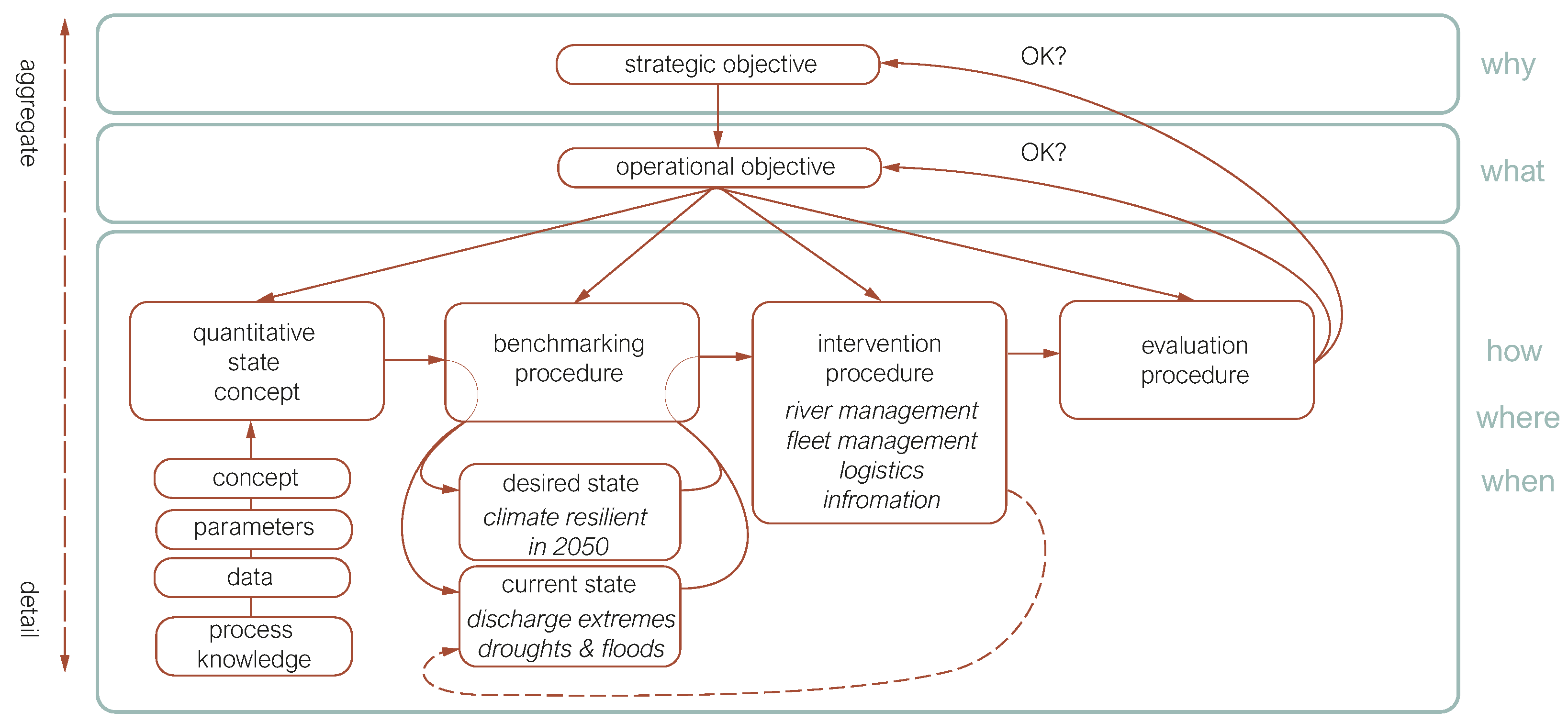
Table 2 summarizes the above findings in one aggregated FoR table, outlining the state of waterway policy in the Netherlands. The rows represent each of the elements of the basic FoR template as shown in Figure 2. The columns represent the four sub-themes. Those cells for which reasonably explicit information could be found in the source documents have been given a light gray back ground. Cells with a white background were not explicitly defined in the source documents used. Combined Table 2 visualizes to what extent each sub-theme has been operationalized.
Examination of Table 2 allows us to make the some key observations following the analysis of source documents:
  • One overarching strategic objective that captures the essence of waterway policy in the Netherlands can be formulated.
  • For each of the underlying sub-themes, operational objectives can be defined that explicitly link to this overarching strategic objective.
  • The sub-themes ‘waterway capacity’ and ‘infrastructure service level’ are fully operationalized in the sense that all elements of the basic FoR template could be made explicit, albeit for regular river discharge conditions.
  • The sub-theme ‘waterway safety’ is largely assumed to be implied when design guidelines are followed. Other than the operational objective, this policy does not set any specific target. An intervention procedure has been expressed in a policy framework letter sent to the Dutch parliament [88]. The remaining basic FoR template elements, however, are left unspecified. This makes it very difficult to implement the proposed intervention effectively.
  • The sub-theme ‘clean and sustainable waterway transport’ has a clear operational objective that follows EU legislation. Also, the desired state of the system is quite clearly defined. The rest of the basic FoR template elements, however, are left unspecified. This makes it very difficult to quantify the current system state and to design packages of measures that help to bring the system towards the desired state and ultimately achieve the operational objective.
  • All sub-themes fail to explicitly address the ‘all conditions’ element in the overarching strategic objective. Of course this does not imply that no actions are taken under extreme discharge conditions. Rather, this means that such actions, when they are taken, are not embedded in a fully developed policy frame of reference.
In particular the observation in the last bullet links to the issue of the climate resilience of inland shipping that this paper aims to address. The following sub-section explores the implications that this lacking clarity can have.

3.2. IWT Policy Behavior Under Extreme Conditions

The previous sub-section observed that the current waterway policy, as summarized in Table 2, does not explicitly address the ‘all conditions’ element in the overarching strategic objective. To challenge the performance of the overall policy for extreme conditions, we contrast our document-based ‘IWT policy FoR’ with the assumed FoRs of barge operators [71]. Table 3, Table 4, Table 5 and Table 6 present the results of this comparison.
Table 3 shows how all FoR elements can be filled for the sub-theme ‘waterway capacity’, both from the perspective of the waterway authority and from the perspective of barge operators. An observable difference between the two perspectives is that the waterway authority mainly focuses on the long-term management of the waterway’s capacity. The policy guidelines mainly focus on waterway dimensions and guaranteeing sufficient capacity under regular conditions. The barge operator experiences these dimensions as boundary conditions and aims to make the best use of the available capacity. As such, the barge operator mainly focuses on the short-term availability of the waterway’s capacity. The differences between both perspectives mainly become visible in the the intervention procedure.
While Rijkswaterstaat’s policy is mainly focused on establishing the long-term boundary conditions for competitive IWT performance, it also acts to improve its performance under more extreme conditions. In the short-term Rijkswaterstaat can, for instance, inform the barge operators about the navigability on the waterway. With better information barge operators can make better decisions, and this is also true under extreme conditions. Furthermore, Rijkswaterstaat decides about water diversion according the ‘sequence of priorities’ in case of extreme water shortage. Decisions to divert water in support of one user function (e.g., drinking water availability, agricultural use, industrial use, etc.) can negatively impact other functions such as IWT. The main effect on waterway capacity is that water diversion to one corridor will lead to lower water levels on another. Especially when water levels are extremely low already, just a few centimeters less water depth will severely impact already sub-optimal loading rates. In the current situation the additional costs for IWT are not estimated, which makes including the interests of IWT in a quantitative trade-off with other user functions impossible.
The long-term river engineering measures, such as bed level improvements or the construction of longitudinal dams, could also be considered to improve navigation conditions under low discharge regimes. Such measures have high investment costs and also impact other functions. Cost–benefit analyses should be performed to investigate whether the cost for improving navigability is reasonable given the achievable benefits. Likewise, barge operators could also implement strategic measures to prepare for extreme discharge conditions. Next to loading rate optimization and route selection, they might also think of temporarily expanding their stocking capabilities or investing in alternative vessels, i.e., making use of lighter materials, different types of propulsion, and different hull shapes. Just like the river engineering measures, these measures also require high investment costs that need to be analyzed for their economic viability. An important factor in these decisions is the expected frequency and duration of these extreme events.
Table 4 shows the results for the sub-theme ‘waterway safety’. In the case that the waterway is designed according the regulations, it is assumed that safe transport is possible. Barge operators can ensure safe transport by applying sufficient underkeel clearance, maneuvering in a safe manner, and acting according the regulations [63,64].
During low discharge extremes the navigable conditions deteriorate, and the risk of accidents and groundings increases. From the barge operators’ perspective, safe transport deals with their own crew and the cargo, the other waterway users, the environment, and the built environment.
Regarding the first aspect, the propellers of vessels in these shallow conditions are situated less deeply in the water, so they are more difficult to stop. Additionally, some vessels take barges alongside them to increase the transport capacity per trip. Such combinations are harder to control, and most of the barge operators have less sailing experience with these types of configurations. Training of personnel could improve the operational skills of barge operators. Additional support systems could help staff to reduce the risk on collisions and groundings.
To compensate for the loss of transport capacity per individual vessel, more vessels are deployed, while less space is available on the waterway. This increases the risk of collisions between ships. Furthermore, barge operators are allowed to navigate with smaller keel clearance and draughts up to the MGD. All these aspects increase the risk of accidents and groundings.
To manage these risks Rijkswaterstaat can implement traffic measures, e.g., one-way or one-lane traffic to decrease the risk of accidents. Such measures are intended to improve waterway safety, but they also affect waterway capacity, infrastructure service level, and sustainable waterway transport, and they have the potential to cause cascading effects further in the system.
Table 5 shows the results for the sub-theme ‘infrastructure service level’. In principle both the waterway authority and the barge operator have the objective of minimizing the waiting and operation times to pass locks and bridges in order to reduce the total travel time and safeguard the reliability of IWT. Again there is the difference that Rijkswaterstaat’s policy aims for the long-term and average reliability of such infrastructure, while barge operators typically have a shorter time frame to consider. Of course the long-term service levels that may be expected are an important business case boundary condition, but especially during discharge extremes, the barge operators are dependent on the operation of the infrastructure by Rijkswaterstaat for their more short-term decision making. During prolonged droughts, in order to minimize water losses, the locking schedule at the Meuse was changed, for example, which caused waiting times to increase [79]. During high discharge events the passage of bridges might become a potential bottleneck [98]. Fixed bridges affect the maximum loading rate of container vessels. Flexible bridges may be able to operate under extreme discharge conditions as well, but bridge openings may affect other modalities. Rijkswaterstaat communicates about operating regimes, passing restrictions and expected waiting times to allow barge operators to fine tune their operations. Based on this information they can plan their arrival or decide to take another route if that is possible to ensure reliable and timely delivery of goods.
Another issue that causes a drop in the service level of locks and bridges is planned or unplanned operational disruptions. The duration of these incidents can especially affect the estimated time of arrival at the destination, and therefore, the supply of goods becomes more uncertain and less reliable. Also, an insufficient number of operators could endanger the operation of the infrastructure.
Table 6 shows the results of the sub-theme ‘clean and sustainable waterway transport’. While Rijkswaterstaat is responsible for affecting the agreed upon reduction of air pollutant emissions and carbon footprint by 2030 for the waterway system under their control, the barge operators are mainly responsible for the fleet that they operate. Of course both stakeholders are mutually dependent upon each other. Rijkswaterstaat can set boundary conditions to affect change, but it is the barge operator that has to take action to modify their equipment and change the way they operate it. In practice this is difficult due to a lack of regulations to create a viable business case for barge owners. Although the European Renewable Energy Directive and Emissions Trading System are in effect, it is still a challenge to implement and to apply on a national level.
The goals of the waterway sustainability policy are clear, as they follow the EU Green Deal and the Fit for 55 packages of measures. However, the underlying decision framework is less clear. There is no clear waterway network emission estimation tool that quantifies the emissions related to water transport. Tools that are available, such as the Aerius toolkit for NOx emission estimation [99], are quite coarse and lack a clear link to IWT. The estimation of emissions under varying discharge extremes is especially important. For low water situations, the reduced water depth causes vessel resistance and fuel consumption to increase significantly. Also, the increase in trips leads to an increase in emissions. For high water situations increased currents might positively or negatively impact fuel consumption, depending on whether the vessel sails with or against the current.
Just like with the other sub-themes, any measure that is taken by authorities to manage the waterway under discharge extremes will affect the other waterway sub-themes, other user functions that also rely on the river, and could cause cascading effects in the system. It is clear that with parts of the waterway policy not being fully operationalized, quantifying the effects of policy measures on other sub-themes, user functions, and parts of the system is problematic. With IPCC predictions that river discharge extremes are likely to occur more frequently and to become more severe, addressing these shortcomings should be considered.

4. Discussion, Conclusions, and Recommendations

Following the observation at the start of this paper that studies that systematically discuss policy objectives related to the IWT function in the context of climate resilience appear to be missing from the literature, the aim of this paper was to systematically ‘objectify’ the Dutch IWT policy and the decision frameworks that are in place to achieve its goals. The results of the systematic analysis of four policy sub-themes, based on a selection of source documents and data sources, was presented in Table 2. Besides varying levels of operationalization, it was observed that none of the four sub-themes explicitly addressed decision making under extreme discharge conditions. To challenge the performance of the overall policy for these extreme conditions, the overall IWT policy FoR was contrasted with the assumed FoRs of logistic service providers during periods of extreme discharge. This section discusses the approach that was followed before outlining some overall conclusions and recommendations for further research.

4.1. Discussion

A first point for discussion is whether another analyst would come to exactly the same tables having the same source documents at his/her disposal. The answer is that most probably this would not be the case. It is important to realize, however, that the Frame of Reference approach as developed by Van Koningsveld [58], Van Koningsveld and Mulder [41], and de Vries et al. [42] was never intended to be a ‘deterministic’ method that delivers the same results regardless of who applies it. Rather, the method intends to make the implicit explicit in a systematic and transparent way so that it may stimulate focused discussions between specialists and the end users of specialist knowledge. Mulder et al. [100] already proposed to handle ill-defined problems by organizing the required ‘specialist–end user’ communication in a problem-driven manner in which stakeholders jointly attempt to make the essential components of management decisions explicit and use the resulting image as a starting point for further information-gathering strategies.
To prevent discussions from becoming too abstract, Van Koningsveld [58] and Van Koningsveld et al. [101] proposed to use the “Game, Set, and Match” principle. The ‘Game’ phase refers to the initial interpretation of source documents and exchange of expert input to explore the decision problem at hand. The outcome of this phase is then ‘Set’ in terms of the basic FoR template elements, making it available for scrutiny and discussion. The ‘Match’ phase involves discussing the presented FoR summary with other stakeholders, allowing them to ‘Match’ their expertise and potential additional information sources to this summary, either modifying or sharpening the FoR summary. The outcomes of the ‘Match’ phase can trigger a new iteration. The efforts in this paper can be regarded as a first round of a “Game, Set, and Match” cycle, where the results presented in Section 3 are now ready to enter the Match phase in the form of peer interaction.
Another point for discussion regards the detail level of the analysis. Here we prioritized first of all the integral coverage of sub-themes that are important to waterway policy. The analysis of each of the sub-themes could clearly have gone into a greater level of detail. The capacity analysis, for example, could have included a detailed comparison of corridors with different class designations, the safety analysis could have included the interaction between cargo and recreation vessels, the service level analysis could have included the availability of inland ports and resting places, etc. Each of these considerations is obviously valid, and their inclusion in further iterations is probably warranted. To keep the scope of the analysis in this paper manageable, however, we chose to perform this first iteration at a slightly more aggregated level. Despite the fact that this means that there is ample room for more detail, we believe that the summary FoR presented in Table 2 represents a valuable first insight into the state of Dutch waterway policy.
As mentioned, there are a wide variety of other methods available to assess the climate resilience of waterborne supply chains. In these methods the quantitative analysis is mainly focused on the performance of a system during extreme conditions, but they ignore the strategic and operational objectives of the system. For example the option to change the strategic or operational objectives as an adaptation or mitigation measure is lacking in those analyses. The FoR provides a more comprehensive playing field based on the governing policies to make a system resilient.
The results of the analysis show that some of the sub-themes are operationalized while some elements are vague or implicit. Therefore, these elements should be made more explicit in the current policies for these sub-themes. Such a comprehensive playing field could be constructed for decision-making about a climate-resilient inland waterway transport network.

4.2. Conclusions

With the above discussion points in mind, we feel confident drawing the following conclusions:
  • We have succeeded in conforming with the aim of this paper to systematically ‘objectify’ the Dutch IWT policy and the decision frameworks that are in place to achieve its goals.
  • Compared to previous literature that mainly focused on function loss in terms of IWT transport capacity during extreme discharge conditions, we have shown that additional aspects to consider are waterway safety, infrastructure service level, and clean and sustainable waterway transport.
  • One overarching strategic objective can be formulated that captures the essence of waterway policy in the Netherlands, while for each of the underlying sub-themes, operational objectives can be defined that explicitly link to the overarching strategic objective.
  • The systematic analysis of source documents revealed that the four sub-themes of Dutch waterway policy have different levels of operationalization.
    -
    The sub-themes ‘waterway capacity’ and ‘infrastructure service level’ are fully operationalized in the sense that all elements of the basic FoR template could be made explicit.
    -
    The sub-theme ‘waterway safety’ is largely assumed to be implied when design guidelines are followed. Other than that, the operational objective does not set any specific target. An intervention procedure has been expressed in a policy framework letter sent to the Dutch parliament [88]. The remaining basic FoR template elements, however, are left undefined. This makes it very difficult to implement the proposed intervention effectively.
    -
    The sub-theme ‘clean and sustainable waterway transport’ has a clear operational objective that follows EU legislation. Also, the desired state of the system is quite clearly defined. The rest of the basic FoR template elements, however, are left undefined. This makes it very difficult to quantify the current system state and to design packages of measures that can help to bring the system towards the desired state and ultimately achieve the operational objective.
  • All sub-themes fail to explicitly address the ‘all conditions’ element in the overarching strategic objective. Of course this does not imply that no actions are taken under extreme discharge conditions, be they high or low. Rather, this means that such actions, when they are taken, are not embedded in a fully developed policy frame of reference.
  • A comparison of the summarized IWT policy FoR with the assumed FoRs of barge operators under extreme discharge conditions helped to illustrate the extent to which the standing IWT policy aligns with the practical concerns of one of the key IWT stakeholders in cases of discharge extremes. The importance of being able to quantify how measures for any IWT sub-theme or user function affect the others is a recurring issue.

4.3. Recommendations

Based on the conclusions presented here, we observe that a lot is still unknown when it comes to the behavior of IWT under extreme discharge conditions. The lack of a well-established framework to consider trade-offs between river functions, including IWT, in times of extreme discharge, introduces the substantial risk that management measures aimed to support one user function inadvertently impacts other user functions negatively. Given the substantial economic value of IWT, considering that both national and EU policy makers endeavor to promote a substantial modal shift from road and rail to water, and given the realization that the IPCC predicts that extremes in the water cycle are expected to increase, we recommend further research into the behavior of various river functions, including IWT, under river discharge extremes.
First of all we recommend a more detailed investigation into the response of IWT to discharge extremes. With the currently available data on river discharges and corresponding changes in water depths along the river as well as vessel movements and corresponding transport volumes, it should be possible to get a much more detailed insight into how inland shipping behaves in these conditions. Do different vessel types respond differently? Do different cargo types behave differently? To what extent are the observed changes explained by human behavior and to what extent are they explained by physical or regulatory restrictions?
Second, we recommend investigating how these observed changes can be captured in simulations that explicitly link the behavior of water transport chains with the state of the physical environment. Current models to analyze water transport behavior are not easily coupled with hydrodynamic models. This inhibits the investigation of how water transport patterns change as a result of extreme high or low river discharges. Also, current water transport models are not sufficiently capable to account for the system-scale effects that have been observed in practice.
In this paper, ongoing policy developments are not included in the quantification. It could provide valuable insights to incorporate these kind of developments. As an example, in the Room for the River 2.0 [102] program, the river management policy describes how the rivers in the Netherlands will be maintained and conserved and what this means for the river functions.
Further investigations into these topics should improve our capability to translate water transport policies, as objectified in this paper, into quantitative assessments, which allows us (1) to specify how much the system’s current state differs from its desired state and (2) to assess which packages of measures would most effective for bringing the system to its desired state. It is important that further investigations not only address average river discharge conditions but also the more extreme conditions. This will enhance our insights into shipping-related decision challenges during climate extremes.
While some of the observations presented in this paper are specifically applicable to the Dutch inland waterway network, the method applied in this paper could also be used for other river systems that support multiple functions. Based on the documents presented in Section 1 together with other policy documents and technical standards, a more detailed analysis using FoR could be executed for rivers, e.g., in the USA, Argentina, and China in future research.

Author Contributions

Conceptualization, F.V. and M.v.K.; methodology, F.V. and M.v.K.; formal analysis, F.V.; investigation, F.V.; resources, F.V.; data curation, F.V.; writing—original draft preparation, F.V.; writing—review and editing, M.v.K. and C.v.D.; visualization, F.V.; supervision, M.v.K. All authors have read and agreed to the published version of the manuscript.

Funding

This research is financially supported by Rijkswaterstaat and SmartPort which is a collaboration between the Port of Rotterdam, universities, institutes and companies in the IWT sector.

Data Availability Statement

Not applicable.

Acknowledgments

The authors thank Rijkswaterstaat for sharing documents, information, knowledge, and experiences about extreme events, specifically the project Climate Resilient Networks.

Conflicts of Interest

The funders had no role in the design of the study; in the collection, analyses, or interpretation of data; in the writing of the manuscript, or in the decision to publish the results.

Abbreviations

The following abbreviations are used in this manuscript:
ALRAgreed Low River Discharge
AISAutomatic Identification System
CCNRCentral Commission for the Navigation of the Rhine
FoRFrame of Reference
HSWHoogste Scheevaart Waterstand
IPCCIntergovernmental Panel on Climate Change
IVSInformatie- en Volgsysteem voor de Scheepvaart
IWTInland Water Transport
I&WInfrastructure and Watermanagement
MGDMinste Gepeilde Diepte
NISNetwerk Informatie Systeem
TEN-TTrans-European Transport Network

References

  1. Wang, H.; He, G. Rivers: Linking nature, life, and civilization. River 2022, 1, 25–36. [Google Scholar] [CrossRef]
  2. Mens, M.J.P.; van Rhee, G.; Schasfoort, F.; Kielen, N. Integrated drought risk assessment to support adaptive policymaking in the Netherlands. Nat. Hazards Earth Syst. Sci. 2022, 22, 1763–1776. [Google Scholar] [CrossRef]
  3. Nilsson, C.; Renöfält, B.M. Linking Flow Regime and Water Quality in Rivers: A Challenge to Adaptive Catchment Management. Ecol. Soc. 2008, 13, 20. [Google Scholar] [CrossRef]
  4. Acreman, M.; Arthington, A.H.; Colloff, M.J.; Couch, C.; Crossman, N.D.; Dyer, F.; Overton, I.; Pollino, C.A.; Stewardson, M.J.; Young, W. Environmental flows for natural, hybrid, and novel riverine ecosystems in a changing world. Front. Ecol. Environ. 2014, 12, 466–473. [Google Scholar] [CrossRef]
  5. van Vliet, M.; Zwolsman, J. Impact of summer droughts on the water quality of the Meuse river. J. Hydrol. 2008, 353, 1–17. [Google Scholar] [CrossRef]
  6. Intergovernmental Panel on Climate Change (IPCC). Technical Summary. In Climate Change 2021—The Physical Science Basis: Working Group I Contribution to the Sixth Assessment Report of the Intergovernmental Panel on Climate Change; Technical Report; Cambridge University Press: Cambridge, UK, 2023; pp. 35–144. [Google Scholar] [CrossRef]
  7. Thomson, E. Droughts Are Creating New Supply Chain Problems. This Is What You Need to Know. 2023. Available online: https://www.weforum.org/agenda/2023/10/drought-trade-rivers-supply-chain/ (accessed on 20 September 2024).
  8. Liu, Y.; Yuan, S.; Zhu, Y.; Ren, L.; Chen, R.; Zhu, X.; Xia, R. The patterns, magnitude, and drivers of unprecedented 2022 mega-drought in the Yangtze River Basin, China. Environ. Res. Lett. 2023, 18, 114006. [Google Scholar] [CrossRef]
  9. Bloomberg. Historic Drought Threatens to Cripple European Trade. 2022. Available online: https://www.straitstimes.com/world/europe/historic-drought-threatens-to-cripple-european-trade (accessed on 20 September 2024).
  10. Dutchnews. Meuse Drinking Water Provision Under Threat from Drought. 2019. Available online: https://www.dutchnews.nl/2019/09/meuse-drinking-water-provision-under-threat-from-drought/ (accessed on 9 October 2024).
  11. Ligtenberg, J.; Vinke, F. Comparing Navigability of The Dutch Rivers Meuse and Waal Following the Pardé-Coefficient. In Proceedings of the 35th PIANC World Congress 2024: Future Ready Waterborne Transport—Unlocking Africa, PIANC 2024, Cape Town, South Africa, 29 April–3 May 2024; Schoonees, J., Ed.; PIANC: Brussels, Belgium, 2024; pp. 1432–1436. [Google Scholar]
  12. Ministerie van Infrastructuur en Waterstaat; Ministerie van Landbouw, Natuur en Voedselkwaliteit; Ministerie van Binnenlandse Zaken en Koninkrijkrelaties. Nationaal Water Programma 2022–2027; Het Nationale Waterbeleid en de Uitvoering in de Rijkswateren; Technical Report; Rijksoverheid: Den Haag, The Netherlands, 2022.
  13. Rijkswaterstaat. Verdringingsreeks bij Watertekort. 2020. Available online: https://www.infomil.nl/onderwerpen/lucht-water/handboek-water/thema-s/watertekort/verdringingsreeks/ (accessed on 20 September 2024).
  14. OECD. Water Governance in the Netherlands; OECD Publishing: Paris, France, 2014; p. 296. [Google Scholar] [CrossRef]
  15. Van Dorsser, C.; Vinke, F.; Hekkenberg, R.; Van Koningsveld, M. The effect of low water on loading capacity of inland ships. Eur. J. Transp. Infrastruct. Res. 2020, 20, 47–70. [Google Scholar] [CrossRef]
  16. Vinke, F.; van Koningsveld, M.; van Dorsser, C.; Baart, F.; van Gelder, P.; Vellinga, T. Cascading effects of sustained low water on inland shipping. Clim. Risk Manag. 2022, 35, 15. [Google Scholar] [CrossRef]
  17. Vinke, F.; Turpijn, B.; van Gelder, P.; van Koningsveld, M. Inland shipping response to discharge extremes—A 10 years case study of the Rhine. Clim. Risk Manag. 2023, 43, 100578. [Google Scholar] [CrossRef]
  18. Streng, M.; van Saase, N.; Kuipers, B. Economische Impact Laagwater; Technical Report; Erasmus Centre for Urban, Port and Transport Economics: Rotterdam, The Netherlands, 2020. [Google Scholar]
  19. Trenczek, J.; Lühr, O.; Eiserbeck, L.; Sandhövel, M.; Leuschner, V. Estimation of Costs Resulting from Climate Change in Germany. 2023. Available online: https://www.prognos.com/en/project/estimation-costs-climate-change-germany (accessed on 9 October 2024).
  20. European Commission. Climate Resilient and Environmentally Sustainable Transport Infrastructure, with a Focus on Inland Waterways. 2021. Available online: https://ec.europa.eu/info/funding-tenders/opportunities/portal/screen/opportunities/topic-details/horizon-cl5-2021-d6-01-09 (accessed on 10 October 2024).
  21. European Commission. Climate Resilient and Safe Maritime Ports. 2023. Available online: https://blue-economy-observatory.ec.europa.eu/calls-proposals/climate-resilient-and-safe-maritime-ports-horizon-cl5-2023-d6-01-09_en (accessed on 10 October 2024).
  22. Van der Mark, R.; De Jong, J.; Weiler, O.; Rujgh, E. Stresstest Indirecte Bedreigingen—Verkenning Externe Invloeden op Het Hoofdvaarwegennetwerk; Technical Report; Deltares: Delft, The Netherlands, 2021. [Google Scholar]
  23. Hagenlocher, M.; Naumann, G.; Meza, I.; Blauhut, V.; Cotti, D.; Döll, P.; Ehlert, K.; Gaupp, F.; Van Loon, A.F.; Marengo, J.A.; et al. Tackling Growing Drought Risk—The Need for a Systemic Perspective. Earth’s Future 2023, 11, e2023EF003857. [Google Scholar] [CrossRef]
  24. Rossi, L.; Blàhovà, M.; Blauhut, V.; De Moel, H.; Cotti, D.; Hagenlocher, M.; Kohn, I.; Van Loon, A.; Maetens, W.; Masante, D.; et al. The EDORA project: Towards a multi-sectoral drought risk assessment in Europe. In Proceedings of the EGU General Assembly 2023, Vienna, Austria, 23–28 April 2023. [Google Scholar] [CrossRef]
  25. Gu, B.; Liu, J. A systematic review of resilience in the maritime transport. Int. J. Logist. Res. Appl. 2025, 28, 257–278. [Google Scholar] [CrossRef]
  26. CCB Wageningen-UR Klimaat voor Ruimte, Ruimte voor Klimaat. 2003. Available online: https://www.ccb.wur.nl/index_files/main_files/ICESKIS.html (accessed on 2 February 2025).
  27. Jonkeren, O.; Rietveld, P.; Van Ommeren, J. Climate change and Inland Waterway Transport—Welfare effects of low water levels on the river Rhine. J. Transp. Econ. Policy 2007, 41, 387–411. [Google Scholar]
  28. Driessen, P.; Vellinga, P.; van Deelen, C.L.; Slegers, M.F.W.; Dopp, S.P.; Heinen, M.; de Pater, F.; Piek, O.; van Nieuwaal, K. Kennis voor Klimaat 2008–2014; Verantwooding & Resultaten; Technical Report; Stichting Kennis voor Klimaat: Utrecht, The Netherlands, 2015. [Google Scholar]
  29. Van Meijeren, J.; Groen, T. Impact of Climate Change on the Competitive Position of Inland Waterway Transport; Technical Report; Knowledge for Climate: Utrecht, The Netherlands, 2010. [Google Scholar]
  30. Krekt, A.; Van der Laan, T.J.; Van der Meer, R.A.E.; Turpijn, B.; Van der Toorn, A.; Mosselman, E.; Meijeren, J.; Groen, T. Climate Change and Inland Waterway Transport: Impacts on the Sector, the Port of Rotterdam and Potential Solutions; Technical Report; Knowledge for Climate: Utrecht, The Netherlands, 2011. [Google Scholar]
  31. Van Meijeren, J.; Groen, T.; Vonk Noordergraaf, D. Impact of climate change on the competitive position of Inland Waterways Transport and logistic solutions. In Proceedings of the European Transport Conference, Glasgow, UK, 10–12 October 2011; Association for European Transport and Contributers: London, UK, 2011; pp. 1–14. [Google Scholar]
  32. Turpijn, B.; Weekhout, R. Klimaat en Binnenvaart—Een Strategische Verkenning naar de Effecten van Klimaatverandering op het Gebruik van het Hoofdvaarwegennet; Technical Report; Rijkswaterstaat: Utrecht, The Netherlands, 2011. [Google Scholar]
  33. ECCONET. Effects of Climate Change on Inland Waterway Networks. 2012. Available online: https://climate-adapt.eea.europa.eu/en/knowledge/adaptation-information/research-projects/econnet (accessed on 20 February 2025).
  34. Hendrickx, C.; Breemersch, T. The Effect of Climate Change on Inland Waterway Transport. Procedia—Soc. Behav. Sci. 2012, 48, 1837–1847. [Google Scholar] [CrossRef]
  35. De Jong, J.; van der Mark, R. KBN—Stresstest Droogte—Mogelijke Maatregelen; Technical Report; Deltares: Delft, The Netherlands, 2021. [Google Scholar]
  36. Hiemstra, K.S.; van Vuren, S.; Vinke, F.S.R.; Jorissen, R.E.; Kok, M. Assessment of the functional performance of lowland river systems subjected to climate change and large-scale morphological trends. Int. J. River Basin Manag. 2022, 20, 45–56. [Google Scholar] [CrossRef]
  37. Bakker, F.P.; van der Werff, S.; Baart, F.; Kirichek, A.; de Jong, S.; van Koningsveld, M. Port Accessibility Depends on Cascading Interactions between Fleets, Policies, Infrastructure, and Hydrodynamics. J. Mar. Sci. Eng. 2024, 12, 1006. [Google Scholar] [CrossRef]
  38. Bakker, F.P.; Hendrickx, G.; Keyzer, L.; Iglesias, S.; Aarninkhof, S.; van Koningsveld, M. Trading off Dissimilar Stakeholder Interests: Changing the Bed Level of the Main Shipping Channel of the Rhine-Meuse Delta While Considering Freshwater Availability. Environ. Challenges, 2024; in review. [Google Scholar] [CrossRef]
  39. Haasnoot, M.; Kwakkel, J.H.; Walker, W.E.; ter Maat, J. Dynamic adaptive policy pathways: A method for crafting robust decisions for a deeply uncertain world. Glob. Environ. Change 2013, 23, 485–498. [Google Scholar] [CrossRef]
  40. Wienk, T. Evaluation of the Resilience of Inland Waterway Transport to Increasing Periods of Low Flow, Following a Dynamic Adaptive Policy Pathway Approach. Master’s Thesis, Delft University of Technology, Civil Engineering and Geosciences, Hydraulic Engineering—Ports and Waterways, Delft, The Netherlands, 2019. [Google Scholar]
  41. Van Koningsveld, M.; Mulder, J. Sustainable coastal policy developments in the Netherlands. A systematic approach revealed. J. Coast. Res. 2004, 20, 375–385. [Google Scholar] [CrossRef]
  42. de Vries, M.; van Koningsveld, M.; Aarninkhof, S.; de Vriend, H. A systematic design approach for objectifying Building with Nature solutions. Res. Urban. Ser. 2021, 7, 29–49. [Google Scholar] [CrossRef]
  43. Galat, D.L.; Barko, J.W.; Bartell, S.M.; Davis, M.; Johnson, B.L.; Lubinski, K.S.; Nestler, J.M.; Wilcox, D.B. Environmental Science Panel Report: Establishing System-Wide Goals and Objectives for the Upper Mississippi River System; Technical Report; U.S. Army Corps of Engineers: Rock Island, IL, USA; St. Louis, MO, USA; St. Paul, MN, USA, 2007.
  44. The World Bank Group. Guidelines for a Ports and Inland Waterways Strategy in Argentina; Technical Report; The World Bank Group: Washington, DC, USA, 2022. [Google Scholar]
  45. Amos, P.; Dashan, J.; Tao, N.; Junyan, S.; Weijun, F. Sustainable Development of Inland Waterway Transport in China; Technical Report; The World Bank and the Ministry of Transport, People’s Republic of China: Beijing, China, 2009. [Google Scholar]
  46. Van Koningsveld, M.; Davidson, M.; Huntley, D.; Medina, R.; Aarninkhof, S.; Jiménez, J.A.; Ridgewell, J.; de Kruif, A. A critical review of the CoastView project: Recent and future developments in coastal management video systems. Coast. Eng. 2007, 54, 567–576. [Google Scholar] [CrossRef]
  47. Medina, R.; Marino-Tapia, I.; Osorio, A.; Davidson, M.; Martin, F. Management of dynamic navigational channels using video techniques. Coast. Eng. 2007, 54, 523–537. [Google Scholar] [CrossRef]
  48. Davidson, M.; Van Koningsveld, M.; de Kruif, A.; Rawson, J.; Holman, R.; Lamberti, A.; Medina, R.; Kroon, A.; Aarninkhof, S. The CoastView project: Developing video-derived Coastal State Indicators in support of coastal zone management. Coast. Eng. 2007, 54, 463–475. [Google Scholar] [CrossRef]
  49. Marchand, M.; Sanchez-Arcilla, A.; Ferreira, M.; Gault, J.; Jiménez, J.A.; Markovic, M.; Mulder, J.; van Rijn, L.; Stănică, A.; Sulisz, W.; et al. Concepts and science for coastal erosion management—An introduction to the Conscience framework. Ocean. Coast. Manag. 2011, 54, 859–866. [Google Scholar] [CrossRef]
  50. Ciavola, P.; Ferreira, O.; Haerens, P.; Van Koningsveld, M.; Armaroli, C.; Lequeux, Q. Storm impacts along European coastlines. Part 1: The joint effort of the MICORE and ConHaz Projects. Environ. Sci. Policy 2011, 14, 912–923. [Google Scholar] [CrossRef]
  51. Ciavola, P.; Ferreira, O.; Haerens, P.; Van Koningsveld, M.; Armaroli, C. Storm impacts along European coastlines. Part 2: Lessons learned from the MICORE project. Environ. Sci. Policy 2011, 14, 924–933. [Google Scholar] [CrossRef]
  52. Garel, E.; Rey, C.C.; Ferreira, Ó.; Van Koningsveld, M. Applicability of the “Frame of Reference” approach for environmental monitoring of offshore renewable energy projects. J. Environ. Manag. 2014, 141, 16–28. [Google Scholar] [CrossRef] [PubMed]
  53. ter Hofstede, R.; van Koningsveld, M. Defining operational objectives for nature-inclusive marine infrastructure to achieve system-scale impact. Front. Mar. Sci. 2024, 11, 1358851. [Google Scholar] [CrossRef]
  54. Tamis, J.; Baptis, M. Historic Case Study Maasvlakte 2—A Review of the Monitoring Plan with Focus on Adaptive Strategies; Technical Report; IMARES Wageningen UR: IJmuiden, The Netherlands, 2011. [Google Scholar]
  55. Laboyrie, P.; Van Koningsveld, M.; Aarninkhof, S.; Van Parys, M.; Lee, M.; Jensen, A.; Csiti, A.; Kolman, R. Dredging for Sustainable Infrastructure; IADC/CEDA: The Hague: Amsterdam, The Netherlands, 2018. [Google Scholar]
  56. Taneja, P.; van Rhede van der Kloot, G.; van Koningsveld, M. Sustainability Performance of Port Infrastructure—A Case Study of a Quay Wall. Sustainability 2021, 13, 11932. [Google Scholar] [CrossRef]
  57. van Koningsveld, M.; Verheij, H.J.; Taneja, P.; de Vriend, H.J. (Eds.) Ports and Waterways: Navigating the Changing World; TU Delft Open: Delft, The Netherlands, 2023. [Google Scholar] [CrossRef]
  58. Van Koningsveld, M. Matching Specialist Knowledge with End User Needs. Bridging the Gap Between Coastal Science and Coastal Management. Ph.D. Thesis, University of Twente, Enschede, The Netherlands, 2003. [Google Scholar]
  59. Rijkswaterstaat. Richtlijnen Vaarwegen 2020; Rijkswaterstaat: Den Haag, The Netherlands, 2020; ISBN 978-90-9033423-3. [Google Scholar]
  60. Rijkswaterstaat. Richtlijnen Scheepvaarttekens 2023; Rijkswaterstaat: Den Haag, The Netherlands, 2023. [Google Scholar]
  61. Green Deal. Green Deal on Maritime and Inland Shipping and Ports; Technical Report; Green Deal: Brussels, Belgium, 2019. [Google Scholar]
  62. European Commission. Reducing Emission from the Shipping Sector. Available online: https://climate.ec.europa.eu/eu-action/transport-emissions/reducing-emissions-shipping-sector_en (accessed on 12 July 2023).
  63. Binnenvaartpolitiereglement. Available online: https://wetten.overheid.nl/BWBR0003628/2017-01-01 (accessed on 19 December 2023).
  64. Ministry of Transport and Water Management. Rijnvaartpolitiereglement 1995; Technical Report; Rijkswaterstaat: Den Haag, The Netherlands, 2018.
  65. Central Commision for the Navigation of the Rhine. Available online: https://ccr-zkr.org/10000000-en.html (accessed on 7 June 2023).
  66. Central Commission for the Navigation of the Rhine. CCNR ROADMAP for Reducing Inland Navigation Emissions; Tech Report; CCNR: Strasbourg, France, 2022. [Google Scholar]
  67. European Commission. Trans-European Transport Network (TEN-T). Available online: https://transport.ec.europa.eu/transport-themes/infrastructure-and-investment/trans-european-transport-network-ten-t_nl (accessed on 4 July 2023).
  68. European Commission. Factsheet—The Transport and Mobility Sector; Technical Report; European Commission: Brussels, Belgium, 2020. [Google Scholar]
  69. Binnenvaart Emissieprestatie Label. Available online: https://binnenvaartemissielabel.nl/ (accessed on 12 July 2023).
  70. European Commission. Roadmap to a Single European Transport Area—Towards a Competitive and Resource Efficient Transport System; Technical Report; European Union: Brussels, Belgium, 2011. [Google Scholar]
  71. Koninklijke Binnenvaart Nederland. Low Water Vision for Inland Shipping in the Netherlands and on the Rhine; Technical Report; Koninklijke Binnenvaart Nederland: Rotterdam, The Netherlands, 2023. [Google Scholar]
  72. CESNI. European Standard Laying Down Technical Requirements for Inland Navigation Vessel (ES-TRIN); Technical Report; CESNI: Strasbourg, France, 2025. [Google Scholar]
  73. CESNI. European Standard for Qualifications in Inland Navigation (ES-QIN); Technical Report; CESNI: Strasbourg, France, 2024. [Google Scholar]
  74. Rijkswaterstaat. Waterinformatie. Available online: https://waterinfo.rws.nl/ (accessed on 30 June 2022).
  75. Rijkswaterstaat. Vaarweginformatie.nl. Available online: https://www.vaarweginformatie.nl/frp/main/#/home (accessed on 30 July 2023).
  76. Rijkswaterstaat. GeoWeb Catalogus. Available online: https://maps.rijkswaterstaat.nl/GeoWebPortaal/ (accessed on 30 June 2022).
  77. Rijksoverheid. Rijkswaterstaat Informatiepunt Water, Verkeer en Leefomgeving (WVL). Available online: https://www.rijksoverheid.nl/contact/contactgids/rijkswaterstaat-water-verkeer-en-leefomgeving-wvl (accessed on 30 June 2022).
  78. De Jong, J. Memo KBN: Potentiele Blootstelling; 11203738-005-BGS-0005; Technical Report; Deltares: Delft, The Netherlands, 2020. [Google Scholar]
  79. Van der Mark, M. Stresstest Droogte Maas—Blootstelling en Kwetsbaarheid bij de Sluiscomplexen; Technical Report; Deltares: Delft, The Netherlands, 2020. [Google Scholar]
  80. Watermanagementcentrum Nederland. Jaaroverzicht 2021; Technical Report; Rijkswaterstaat Verkeer en Watermanagement, Afdeling Water- en Scheepvaartberichtgeving: Lelystad, The Netherlands, 2021. [Google Scholar]
  81. Rijkswaterstaat. Mobility. Available online: https://www.rijkswaterstaat.nl/en/mobility (accessed on 1 May 2023).
  82. Rijkswaterstaat. Main Waterway Network. Available online: https://www.rijkswaterstaat.nl/en/water/water-management/main-waterway-network (accessed on 1 May 2023).
  83. Rijkswaterstaat. Our Mission. Available online: https://www.rijkswaterstaat.nl/en/about-us/our-organisation/our-mission (accessed on 30 July 2023).
  84. CEMT. New Classification of Inland Waterways; Cemt/cm(92)6/Final; European Conference of Ministers of Transport ECMT: Paris, France, 1992. [Google Scholar]
  85. Min V&W (RWS-AVV); CBS. Nederland en de Scheepvaart op de Binnenwateren 2002; Technical Report; Ministerie van Verkeer en Waterstaat, Rijkswaterstaat, Adviesdienst Verkeer en Vervoer (RWS, AVV) and Centraal Bureau voor de Statistiek (CBS): Den Haag, The Netherlands, 2003. [Google Scholar]
  86. CCNR. CCNR Inland Navigation in Europe. Market Observation. Annual Report 2019; Technical Report; Central Commission for the Navigation of the Rhine: Strasbourg, France, 2019. [Google Scholar]
  87. Central Commission for the Navigation of the Rhine. Waterway Profile of the Rhine. Available online: https://ccr-zkr.org/files/documents/infovoienavigable/Wasserstrassenprofil_en.pdf (accessed on 29 June 2023).
  88. Ministerie van Infrastructuur en Waterstaat. Beleidskader Maritieme Veiligheid: In Veilige Vaart Vooruit. Letter to Parliament, Reference: IENW/BSK-2020/218823. 2020. Available online: https://open.overheid.nl/documenten/ronl-560a8640-b48a-4a71-ad08-ea101997919a/pdf (accessed on 20 February 2020).
  89. Beenhakker, C.; Feldbrugge, B. Effecten Klimaatverandering op Nautische Veiligheid; Technical Report; Rijkswaterstaat Water Verkeer en Leefomgeving: Lelystad, The Netherlands, 2020. [Google Scholar]
  90. Verschuren, D. Effects of Drought on the Traffic Capacity of the River Waal and the Occurrence of Congestion. Master’s Thesis, Delft University of Technology, Civil Engineering and Geosciences, Hydraulic Engineering—Ports and Waterways, Delft, The Netherlands, 2020. [Google Scholar]
  91. Rijkswaterstaat. Sluiscapaciteitsstudie Integrale Mobiliteitsanalyse; Technical Report; Tweede Kamer der Staten-Generaal: Den Haag, The Netherlands, 2021. [Google Scholar]
  92. Ministerie van Verkeer en Waterstaat & VROM. Nota Mobiliteit. Naar een Betrouwbare en Voorspelbare Bereikbaarheid; Technical Report; Tweede Kamer der Staten-Generaal: Den Haag, The Netherlands, 2004. [Google Scholar]
  93. Rijkswaterstaat. SLA HVWN 2018-2021: IN A. Betrouwbare Passeertijden; Technical Report; Tweede Kamer der Staten-Generaal: Den Haag, The Netherlands, 2004. [Google Scholar]
  94. PIANC. Infrastructure for the Decarbonisation of Inland Waterway Transport; Technical Report, InCom TG Report 234; PIANC: Brussels, Belgium, 2023. [Google Scholar]
  95. CCNR. CCNR Roadmap for Reducing Inland Navigation Emissions; Technical Report; Central Commission for the Navigation of the Rhine (CCNR): Strasbourg, France, 2022. [Google Scholar]
  96. PIANC. Guidelines for Air Pollutants and Carbon Emissions Performance Indicators for Inland Waterways; Technical Report, InCom WG Report 229; PIANC: Brussels, Belgium, 2024. [Google Scholar]
  97. Van der Werff, S.; Baart, F.; van Koningsveld, M. Merging Multiple System Perspectives: The Key to Effective Inland Shipping Emission-Reduction Policy Design. J. Mar. Sci. Eng. 2025, 13, 716. [Google Scholar] [CrossRef]
  98. Van der Wijk, R.; De Jong, J. Stresstest Doorvaarthoogte Hoofdvaarwegennet-11205274-004-BGS-0021; Technical Report; Deltares: Delft, The Netherlands, 2020. [Google Scholar]
  99. Marra, W.; Jonkers, S.; Schram, J.; de Jongh, L.; Hazelhorst, S.; Nguyen, T.; Brandt, K.; Stolwijk, G.; Glaese, M. Actualisatie AERIUS Calculator 2024; Technical Report; Rijksinstituut voor Volksgezondheid en Milieu RIVM: Bilthoven, The Netherlands, 2024. [Google Scholar]
  100. Mulder, J.; Van Koningsveld, M.; Owen, M.; Rawson, J. Tools and Guidelines for Coastal Zone Management: Applicable to Problems on Sandy Coasts, Tidal Inlets, River and Estuary Mouths; Technical Report, End Report CZM Tools Group COAST3D, Report RIKZ/2001.020, EU Mast Project no. MAS3-CT97–0086; Rijksinstituut voor Kust en Zee (RIKZ): Den Haag, The Netherlands, 2001. [Google Scholar]
  101. Van Koningsveld, M.; Davidson, M.; Huntley, M. Matching Science with Coastal Management Needs: The Search for Appropriate Coastal State Indicators. J. Coast. Res. 2005, 21, 399–411. [Google Scholar] [CrossRef]
  102. Programma Integraal Riviermanagement. Ruimte voor de Rivier 2.0. 2024. Available online: https://www.ruimtevoorderivier.nl/ (accessed on 14 February 2025).
Figure 1. Rhine branches and Meuse in the Netherlands, highlighting key bifurcations at (1) Pannerden (Pannerdense kop) and (2) Westervoort (IJsselkop).
Climate 13 00146 g001
Figure 2. Basic Frame of Reference template (reworked from van Koningsveld et al. [57], by TU Delft—Ports and Waterways, licensed under CC BY-NC-SA 4.0).
Climate 13 00146 g002
Table 1. The “sequence of priorities” according Water Governance applied during severe droughts in the Netherlands. Author: we changed the size of Figure 1 so the alignment of this table is better.
Catergory 1Category 2Category 3Category 4
Safety and the prevention of irriversible damageUtilitiesSmall-scale high quality useOther (economic considerations, also in terms of nature)
1. Stability of flood defence structures1. Drinking water supply1. Temporary spraying of capital-intensive crops1. Shipping
2. Settling and susidence of peat bogs and moorland2. Power supply2. Process water2. Agriculture
3. Nature dependent on soil conditions 3. Nature, as long as no irreversible damage occurs
4. Industry
5. Water recreation
6. Lake fishing
Table 2. Frame of Reference table summarizing the state of waterway policy in the Netherlands. The rows represent the elements of the basic FoR template. The columns represent the four sub-themes. Cells for which reasonably explicit information could be found in the source documents have been given a light gray background. Cells with a white background were not explicitly defined in the source documents used. The underlined text represents the main elements of the strategic objective and the italic parts are based on the literature.
Management ContextWaterway Policy in the Netherlands
Strategic objectiveTo support sustainable economic development
waterways must be passable and safe under all conditions, and …
journey times by water must be reliable.
Sub-themesWaterway capacityWaterway safetyInfrastructure service levelClean and sustainable waterway transport
Operational objectiveTo achieve ‘passable’ waterways all waterway elements should conform to the corridors class designation and the waterway dimensions and layout should conform to the ‘Richtlijnen Vaarwegen’ and the ‘Richtlijnen Scheepvaarttekens’ respectively.Waterway ‘safety’ is implied when waterways are designed conform the recommended dimensions and layout. Safety levels are to be continuously improved, by knowing the largest risks, analyzing these and managing these to an acceptable level.To achieve ‘reliable journey times by water’ the average total waiting time should not exceed 30 min in the busiest months, and 85% of all passages should be able to be completed within this maximum waiting time.To achieve ‘sustainable’ IWT its net greenhouse gas emissions should be reduced by at least 55% by 2030 compared to the 2019 reference, while beyond 2030 net-zero CO2 emissions and a reduction of 30% in NOx and PM emissions should be achieved by 2050.
Quantitative State         ConceptWidth, depth, head clearance, bend curvature, ALR, MGDShip–ship collisions, ship–waterway allisions, near missesPassing times, waiting times, maximum capacity, intensity, I / C ratioEstimated emissions, CO2, NOx, PM
Data sourcesvaarweginformatie.nl, waterinfo.rws.nl, AIS dataS.O.S. databaseIVS data, AIS dataModels, measurements, IVS data, AIS data
Benchmarking—Desired stateNo bottlenecks for class-representative vessels along the corridor, and the waterway dimensions and layout are according to the guidelines.No recorded incidents or near misses per waterway section.Waiting times do not exceed 30 min, and 85% of all passages can be completed within this maximum waiting time. Operational service based on 24/7 systemEstimated greenhouse gas emissions are on track to reduce by 55% in 2030.
Benchmarking—Current stateAre there bottlenecks, non-compliant dimensions, or layout issues?Are there incidents along the waterway sections?Are waiting times increasing (based on observations, or in projections)?Are emission estimations on track to achieve the 55% reduction in 2030?
Intervention procedureImplement infrastructure interventions to resolve bottlenecks or make signage adjustments.Safety levels are to be continuously improved by knowing the largest risks, analyzing these, and managing them to an acceptable level.Implement infrastructure interventions to resolve bottlenecks.Apply measures to stimulate emission reduction (regulations, subsidies, etc.).
Evaluation— operational objectivePolicy appears to be sufficiently operationalized to achieve the desired state.Policy operationalization appears to be implicit; no direct safety indicator is in place.Policy appears to be sufficiently operationalized to achieve the desired state.Policy appears to be not yet fully operationalized. Beyond clear objectives and a desired state, the decision recipe is unspecified.
Evaluation— strategic objectiveThe ‘all conditions’ aspect is not fully developed. No clear policy guidance is available to guide decision-making under discharge extremes.The ‘all conditions’ aspect is not fully developed. No clear policy guidance is available to guide decision-making under discharge extremes.The ‘all conditions’ aspect is not fully developed. No clear policy guidance is available to guide decision-making under discharge extremes.The ‘all conditions’ aspect is not fully developed. No clear policy guidance is available to guide decision-making under discharge extremes.
Table 3. Comparison of the summarized waterway policy’s FoR (see Table 2) with a barge operator’s perspective for the sub-theme of ‘waterway capacity’ under extreme discharge conditions. Cells for which reasonably explicit information could be found in the source documents have been given a light gray background. Cells with a white background were not explicitly defined in the source documents used.
Sub-ThemeWaterway Capacity
FoR Elements Water Authority Perspective Barge Operator or Shipper’s Perspective
Strategic objectiveTo support sustainable economic development, waterways must be passable and safe under all conditions, and journey times by water must be reliable.Deliver a long-term waterborne shipping solution that is profitable, sustainable, reliable, safe, and cost effective.
Operational objectiveTo achieve ‘passable’ waterways all waterway elements should conform to the corridor’s class designation, and the waterway dimensions and layout should conform to the ‘Richtlijnen Vaarwegen’ and the ‘Richtlijnen Scheepvaarttekens’, respectively.Ensure a sufficient flow of goods to enable shippers to maintain seamless, disruption-free operations.
Quantitative state conceptWidth, depth, head clearance, bend curvature, ALR, MGDWaterway-induced loading constraints, utilization rates, and unit costs
Benchmarking Desired stateNo bottlenecks for class-representative vessels along the corridor, and the waterway dimensions and layout are according to the guidelines.A system with ample dimensions and economy of scales that can compete with other transport modes. Enable vessels of specified types and sizes to exploit their cargo capacity with minimal restrictions on draft and air clearance.
Benchmarking Current stateAre there bottlenecks, non-compliant dimensions, or layout issues?Does the current waterway infrastructure provide the necessary dimensions for cost-effective transport? To what extent do the actual waterway dimensions limit the effective utilization of inland vessels?
Intervention procedureImplement infrastructure interventions to resolve bottlenecks or signage adjustments.If depth or head clearance is insufficient, barge operators can adjust loading draft and capacity during low water, use ballast water during high water, choose alternative routes when possible, increase sailing hours and/or speed to offset cargo loss, or take additional dumb barges aside during low water conditions. Shippers can also hire more barges, shift to alternative modes of transport, increase storage capacity, lower production without shutdown of activities, or relocate business.
Evaluation— operational objectivePolicy appears to be sufficiently operationalized to achieve the desired state.Cost-effective, on-time delivery of goods under regular conditions.
Evaluation— strategic objectiveThe ‘all conditions’ aspect is not fully developed.Enable shippers to continue operations without major disruptions to production activities that cause dire consequences (e.g., discontinued production activities and loss of clients).
Table 4. Comparison of the summarized waterway policy FoR (see Table 2) with a barge operator’s perspective for the sub-theme of ‘waterway safety’ under extreme discharge conditions. Cells for which reasonably explicit information could be found in the source documents have been given a light gray background. Cells with a white background were not explicitly defined in the source documents used.
Sub-ThemeWaterway Safety
FoR Elements Water Authority Perspective Barge Operator or Shipper’s Perspective
Strategic objectiveTo support sustainable economic development, waterways must be passable and safe under all conditions, and journey times by water must be reliable.Deliver a long-term waterborne shipping solution that is profitable, sustainable, reliable, safe, and cost effective.
Operational objectiveWaterway ‘safety’ is implied when waterways are designed in conformance with the recommended dimensions and layout. Safety levels are to be continuously improved by knowing the largest risks, analyzing these, and managing them to an acceptable level.Ensure safe transport operations for crew, cargo, other waterway users, the environment, and the built environment, including local residents.
Quantitative state conceptShip–ship collisions, ship–waterway allisions, near missesMonitor onboard safety incidents, collisions, allisions between ships and waterway structures, cargo damage (e.g., from bridge collisions), and dangerous goods accidents with potential for significant external impacts—covering both actual events and near misses.
Benchmarking Desired stateNo recorded incidents and near misses per waterway section.Achieve zero onboard incidents, collisions, allisions, damages, and external safety issues (including near misses).
Benchmarking Current stateAre there incidents along the waterway sections?Track the number of accidents and near-accidents currently occurring.
Intervention procedureSafety levels are to be continuously improved by knowing the largest risks, analyzing these, and managing them to an acceptable level.Provide thorough staff training, enforce clear procedures, adhere to technical standards, and ensure proper certification. Manage responsible working hours, control loading rates and under-keel clearance. Utilize state-of-the-art technical support systems (e.g., stability calculations, draft measurement, bridge clearance warnings, etc.) and maintain clear communication to quickly address potential issues.
Evaluation— operational objectivePolicy operationalization appears to be implicit; no direct safety indicator is in place.Record and review the number of incidents and near misses over a defined period.
Evaluation— strategic objectiveThe ‘all conditions’ aspect is not fully developed.Ensure uninterrupted shipper operations by mitigating risks form unsafe practices or adverse waterway conditions while strengthening the barge operator’s reputation as a reliable partner for their crew, shippers, regulators, and key stakeholders, including insurers and financiers.
Table 5. Comparison of the summarized waterway policy FoR (see Table 2) with a barge operator’s perspective for the sub-theme of ‘infrastructure service level’ under extreme discharge conditions. Cells for which reasonably explicit information could be found in the source documents have been given a light gray background. Cells with a white background were not explicitly defined in the source documents used.
Sub-ThemeInfrastructure Service Level
FoR Elements Water Authority Perspective Barge Operator or Shipper’s Perspective
Strategic objectiveTo support sustainable economic development, waterways must be passable and safe under all conditions, and journey times by water must be reliable.Deliver a long-term waterborne shipping solution that is profitable, sustainable, reliable, safe, and cost effective.
Operational objectiveTo achieve ‘reliable journey times by water’, the average total waiting time should not exceed 30 min in the busiest months, and 85% of all passages should be able to be completed within this maximum waiting time.Ensure reliable and timely delivery of goods that comply with the logistical requirements of the shipper
Quantitative state conceptPassing times, waiting times, maximum capacity, intensity, I / C ratioTotal trip duration, service level and availability of infrastructure, reliability of ETA, sailing frequency, amount of cargo meeting the time requirements of shippers, cargo meeting the closing time of container terminals; for containers, the demurrage and detention costs can also be relevant.
Benchmarking Desired stateWaiting times do not exceed 30 min, and 85% of all passages can be completed within this maximum waiting time.On-time delivery with no unnecessary additional costs involved for the barge operator or shipper.
Benchmarking Current stateAre waiting times increasing (based on observations, or in projections)?Number of on-time deliveries, operational regime of infrastructure and terminals, deviations from ETA due to disruptions and traffic restrictions or failure of onboard operations.
Intervention procedureImplement infrastructure interventions to resolve bottlenecks.Use alternative routes or terminals when available, hire additional ship capacity, provide slack in required lead times. Alternatively, increase storage and offer alternative transport options, e.g., by road or rail.
Evaluation— operational objectivePolicy appears to be sufficiently operationalized to achieve the desired state.Under regular conditions waterway service levels are under pressure due to lack of infrastructure maintenance and staff (e.g., bridge operators).
Evaluation— strategic objectiveThe ‘all conditions’ aspect is not fully developed.Under extreme conditions of high and low discharge or due to staff issues, service levels are not sufficient, and service objectives are no longer met.
Table 6. Comparison of the summarized waterway policy FoR (see Table 2) with a barge operator’s perspective for the sub-theme of ‘clean and sustainable waterway transport’ under extreme discharge conditions. Cells for which reasonably explicit information could be found in the source documents have been given a light gray background. Cells with a white background were not explicitly defined in the source documents used.
Sub-ThemeClean and Sustainable Waterway Transport
FoR Elements Water Authority Perspective Barge Operator Perspective
Strategic objectiveTo support sustainable economic development, waterways must be passable and safe under all conditions, and journey times by water must be reliable.Deliver a long-term waterborne shipping solution that is profitable, sustainable, reliable, safe, and cost effective.
Operational objectiveTo achieve ‘sustainable’ IWT its net greenhouse gas emissions should be reduced by at least 55% by 2030 compared to the 2019 reference, while beyond 2030 net-zero CO2 emissions and a reduction of 30% in NOx and PM emissions should be achieved by 2050.Enable sustainable operations that do not pollute the environment, meet the applicable emission standards, and comply with governing carbon policies.
Quantitative state conceptEstimated emissions, CO2, NOx, PMNumber of spills and the emission volumes of air pollutants (e.g., NOx and particles) and carbon footprint.
Benchmarking Desired stateEstimated greenhouse gas emissions are on track to reduce by 55% in 2030.Zero and near-zero emissions with no significant or irreversible impact on living creatures, the environment, or climate change.
Benchmarking Current stateAre emission estimations on track to achieve the 55% reduction in 2030?Reported spills and emissions
Intervention procedureApply measures to stimulate emission reduction (regulations, subsidies, etc.).Invest in equipment and modify operating procedures to achieve emission reduction while remaining cost competitive (e.g., engine retrofitting/placement, adopting alternative fuels, etc.))
Evaluation— operational objectivePolicy appears not to be fully operationalized yet. Beyond clear objectives and a desired state, the decision process is unspecified.Under regular conditions barge operators and shippers desire to improve the sustainability of their fleet (or the one they hire), but regulations that set standards for sustainability are still insufficient to create a viable business case.
Evaluation— strategic objectiveThe ‘all conditions’ aspect is not fully developed.Under extreme conditions sustainability targets are adversely affected by the state of the waterway. It is unclear how to accommodate this, but the root cause of the problem is already at operational level following the missing business case.
Disclaimer/Publisher’s Note: The statements, opinions and data contained in all publications are solely those of the individual author(s) and contributor(s) and not of MDPI and/or the editor(s). MDPI and/or the editor(s) disclaim responsibility for any injury to people or property resulting from any ideas, methods, instructions or products referred to in the content.

