Article

A Methodological Approach (TOPSIS) to Water Management in Water-Scarce Areas Under Climate Variability Conditions

by
Efthymia Stathi
,
Aristeidis Kastridis
* and
Dimitrios Myronidis
Laboratory of Mountainous Water Management and Control, School of Forestry and Natural Environment, Aristotle University of Thessaloniki, 54124 Thessaloniki, Greece
*
Author to whom correspondence should be addressed.
Climate 2025, 13(4), 78; https://doi.org/10.3390/cli13040078
Submission received: 24 February 2025 / Revised: 26 March 2025 / Accepted: 7 April 2025 / Published: 10 April 2025

Abstract

:
Efficient and sustainable water management measures are required on Mediterranean islands due to water shortages, which are exacerbated by climatic variability and increased tourist traffic. This study uses a multi-criteria decision analysis (MCDA) approach, specifically Technique for Order of Preference by Similarity to Ideal Solution (TOPSIS), to examine and rate water management strategies for three Aegean islands that face significant water shortage: Mykonos, Naxos, and Kos. Three main factors were taken into account in the analysis: preventing groundwater depletion, reducing groundwater deterioration, and managing long-term water demands. Expert questionnaires were used to evaluate eight different alternatives, which included reservoir construction, desalination plants, conserving water in agriculture, and reducing network losses. The results for Mykonos showed specific preferred alternatives, such as desalination plants (R2) and agricultural water conservation (R3), which reflect the island’s low capacity for natural water storage. Constructing reservoirs (R1) and conserving agricultural water (R3) were prioritized in Naxos, showing the significance of storage infrastructure for the island’s large agriculture sector. Kos also supported reservoir construction (R1) and agricultural water conservation (R3), displaying the need for both storage and conservation practices. The least sustainable alternative option on all islands was determined to be water transportation by ship (R8). The present study emphasized the significance of localized projects, the construction of water storage infrastructures, and stakeholder involvement in a comprehensive approach to managing water resources. The results indicate an integrated approach that takes into account infrastructure, conservation, and policy, and they are consistent with previous studies on water management in the Mediterranean. This study highlights the need for adapted combined strategies to achieve sustainable water resource management under climatic variability and offers a framework for managing water shortages in similar regions.

1. Introduction

The methodological approach to water management under water scarcity conditions, both in terms of policy and practice, should focus on specific objectives, according to the causes of water scarcity [1,2]. A holistic approach combining technical and scientific perspectives is necessary for the development and implementation of appropriate management practices towards addressing water scarcity issues. More specifically, practices should be consistent with the assumption that water is a scarce “good” and that its scarcity is being addressed through finite available water resources [3,4].
By applying multi-criteria analysis, it is possible to address complex problems by considering them as a set of individual problems that are coherent with each other and enable decision-makers to manage them easily and effectively [5,6]. Water is directly or indirectly involved in a variety of multi-level activities addressing a wide range of needs. It becomes evident that every complex water resource decision problem constitutes essentially a multi-Criteria analysis problem [7,8,9].
The advantages of multi-criteria analysis are apparent, compared with simple arbitrary judgment, which is not based on any factor analysis. The main advantages that make multi-criteria analysis superior (among others) are that it is clear, open, and thorough [10,11,12].
The choice of objectives and criteria by decision makers is subject to further analysis. The score and weights, in cases where they are used, are clear values and have been determined according to specific techniques. To evaluate the performance of alternative options, it is possible to seek the opinion of experts, so that the responsibility is not necessarily left solely to decision makers [13]. It can provide an important channel of communication both among decision makers and between decision makers and the community [14].
Water-related decisions usually refer to large-scale projects requiring significant investments and usually involving a large segment of the population which are difficult to reverse and whose social acceptance is difficult to predict [15,16,17,18]. Consequently, the planning and decision-making process should be approached in the most scientific manner possible. The main use of these methods concerns the selection or prioritization of projects related to water resources based on economic, environmental, and social criteria [19,20,21]. In addition, multi-criteria analysis has been used in drought event management [22], for assessing the vulnerability of marine aquifers [23], and for the sustainable management of urban stormwater [24], though also in the support of the management of a river under ecological perspectives [25]. Many researchers have applied multi-criteria modeling methods in combination with the use of GIS applications to assess zones with different degrees of flood risk and other natural disasters [26,27,28,29,30,31,32,33,34,35,36]. Multi-criteria analysis has been applied extensively in the management of water resources. Its most common applications in water policy issues concern water allocation in river basins, decisions on land use change, reservoirs, economics, studies of optimal exploitation of aquifers, project evaluation, development policy and planning, water quality management, and port projects [37,38,39,40,41,42,43].
This work utilizes the method of Technique for Order of Preference by Similarity to Ideal Solution (TOPSIS). The TOPSIS method by Hwang and Yoon (1981) [44] was developed as an alternative to the ELimination and Choice Expressing REality (ELECTRE) category of methods. This approach is straightforward, intelligible, user-friendly, and widely applied for water management issues [45,46,47,48,49].
The present work was carried out on three Aegean islands (Naxos, Kos, and Mykonos) that experience intense water scarcity during the summer months, where rainfall is minimal [50]. These three islands were chosen mainly because of the availability of data in comparison with other Aegean islands. In parallel, the demand for water increases rapidly in summer due to the intense tourist traffic on these islands [51]. The objective of this study is to use the TOPSIS technique to investigate the best practices and identify effective solutions that will address the Mediterranean islands’ water scarcity urgent issue. This specific methodology has not been applied so far for this specific area for this purpose and constitutes an original application for solving water scarcity problems in areas of prolonged dry periods and intense tourist development.

2. Materials and Methods
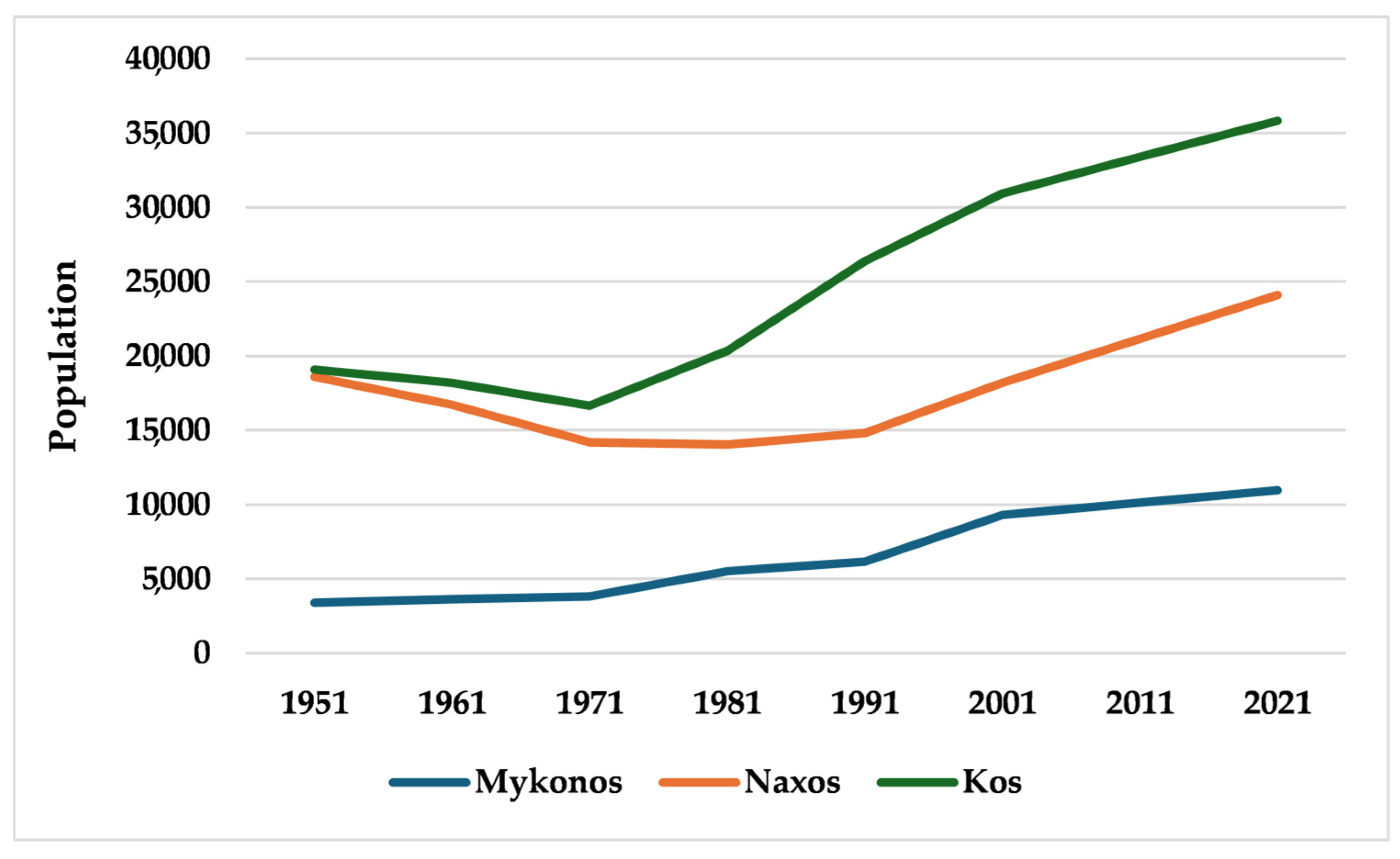
2.1. Study Area

Three South Aegean islands—Mykonos, Naxos, and Kos—were included as the research area (Figure 1). The island of Mykonos occupies 85.5 km2 and is situated in the center of the Cyclades Island complex (10,962 people, Greek census, 2021; Figure 2). With a mean elevation of 100 m above sea level (m.a.s.l.) and a maximum elevation of 365 m.a.s.l, Mykonos is the island with the mildest topography in the study area. Mykonos is the smallest island of this study, with the lowest mean altitude, a fact that it is restrictive for reservoir construction. Furthermore, it is almost entirely lowland, with only a little portion that may be classified as hilly. Mykonos has no forested areas; instead, the majority of the land is covered by pastures (37.64%) and agricultural crops (43.54%), with residential areas making up a smaller portion (16.99%) [52]. Igneous geological formations make up the majority (65.23%), followed by schist formations (9.08%) and alluvial depositions (25.16%).
With a total area of 430 km2, Naxos is the largest and most fertile island of the Cyclades. It is situated south of Mykonos and has 24,098 inhabitants according to the Greek census of 2021. Mount Zas, a small mountain range that runs over Naxos from north to south, forms the island’s geography. The highest peak, Dias or Za, is 989 m.a.s.l., while the average elevation is 263 m.a.s.l.. Although there are some plains and semi-mountainous regions, the majority of the island is classified as hilly. Most of the land is covered by grasslands and shrublands (64.15%) and agricultural crops (34.98%), with no forest areas [52]. The predominant rock types in Naxos are igneous (43.88%) and limestone (48.11%).
Kos’ island area is 282.5 km2, with a population of 35,829 according to the Greek census of 2021; the island is notably elongated, with a steep, uninhabited mountainous axis in the south and a lengthy, densely populated lowland zone in the north. This section’s mountain range is situated along the southern shore, with Mount Dikaios (840 m.a.s.l.) as its highest point and a mean elevation of 127 m.a.s.l.. Kos has some forested areas (6.11%); the majority of the watersheds are covered by agricultural crops (40.89%), and pastures and shrublands (48.89%), and a minor portion is settlements [52]. Igneous formations cover 61.58%, followed by sedimentary formations (25.12%), Schist (7.34%), and limestone formations (5.73%).
The climate of the study area, according to the Koppen/Geiger climate classification is typical Mediterranean climate, with main characteristics being long dry summers and mild winters, while strong winds appear throughout the year [50]. The water demand is highly influenced by the high touristic traffic in summer in combination with the irrigation demands [51].

2.2. Available Water and Water Demand—Water Deficiency Description of the Study Area

2.2.1. Island of Mykonos

Table 1 and Figure 3 present Mykonos’s water system, which is based on data gathered from the water services of the study area and population statistics. The primary water sources are the two reservoirs (Marathi and Ano Mera), seawater desalination, and groundwater. The primary use of water is clean water supply for domestic use. Also, there is a smaller proportion of water demand for livestock activities and small industrial production in the city of Mykonos. In terms of water demand, livestock farming and small industrial production appear to have a higher priority than crop irrigation, based on the stakeholders’ perspective of categorizing the water demand.
By comparing the renewable annual quantities of water (surface and groundwater), the water system of Mykonos appears to be in deficit. Maintaining the current water resource management framework on the island means that the island’s water supply and irrigation system will not be modified at any level (baseline scenario). Maintaining the current situation, in combination with the continuous increase in population (seasonal and permanent), leads to an increase in water demand. It is estimated that over time and given the island’s climatic conditions—low annual rainfall—environmental pressures on the island’s water resources will intensify. Simultaneously, the absence of an alternative water source will force current industrial desalination plants to produce more water, which will increase the cost of water production. As is evident, preserving the current situation may result in significant environmental and economic problems (water shortages for agriculture and tourism, aquifer depletion and degradation, high increase in water cost, and increase in agricultural costs), which will be difficult to overcome in a short period of time and may even be irreversible.

2.2.2. Island of Naxos

Table 2 and Figure 4 show Naxos’ water demand–supply system. Data regarding the amounts of groundwater drawn from boreholes are not available. According to the collected information, the Livadi plain region is experiencing excessive groundwater extraction. Furthermore, the sporadic leasing of a desalination unit for the summer period is an element of the seasonal water shortage during the period of increased touristic activity in the summer months.
The continuous increase in population (seasonal and permanent) leads to an increase in water demand. It is estimated that over time and given the island’s climatic conditions (i.e., low rainfall), environmental pressures on the island’s water resources will intensify, with potential outcomes including the depletion of surface resources, the over-pumping of aquifers, and the expansion of the groundwater salinization phenomenon, particularly in the coastal areas of the island that are supplied exclusively with groundwater.

2.2.3. Island of Kos

The configuration of the water system of Kos is presented in Table 3 and Figure 5. There are no recorded data available on the quantities of groundwater pumped from boreholes. Data show that groundwater is being over-pumped in the area. For example, due to over-pumping, some springs have acquired periodicity in their operation. A typical example is the spring located in the Asklepieion area, which previously had a continuous flow, while in recent years, it dries up during the summer months.
The unplanned boreholes, combined with the short distance between them, over-pumping, and the short distance from the coastal zone, have led to signs of salinization of the aquifers in the area near the beach and mainly in the northern part of the island, where alluvial deposits prevail. Due to over-pumping, the quality of groundwater in the Kardamena area is considered brackish. It becomes apparent that keeping the same management could result in serious economic and environmental issues that will be hard to resolve quickly and might possibly be irreversible.

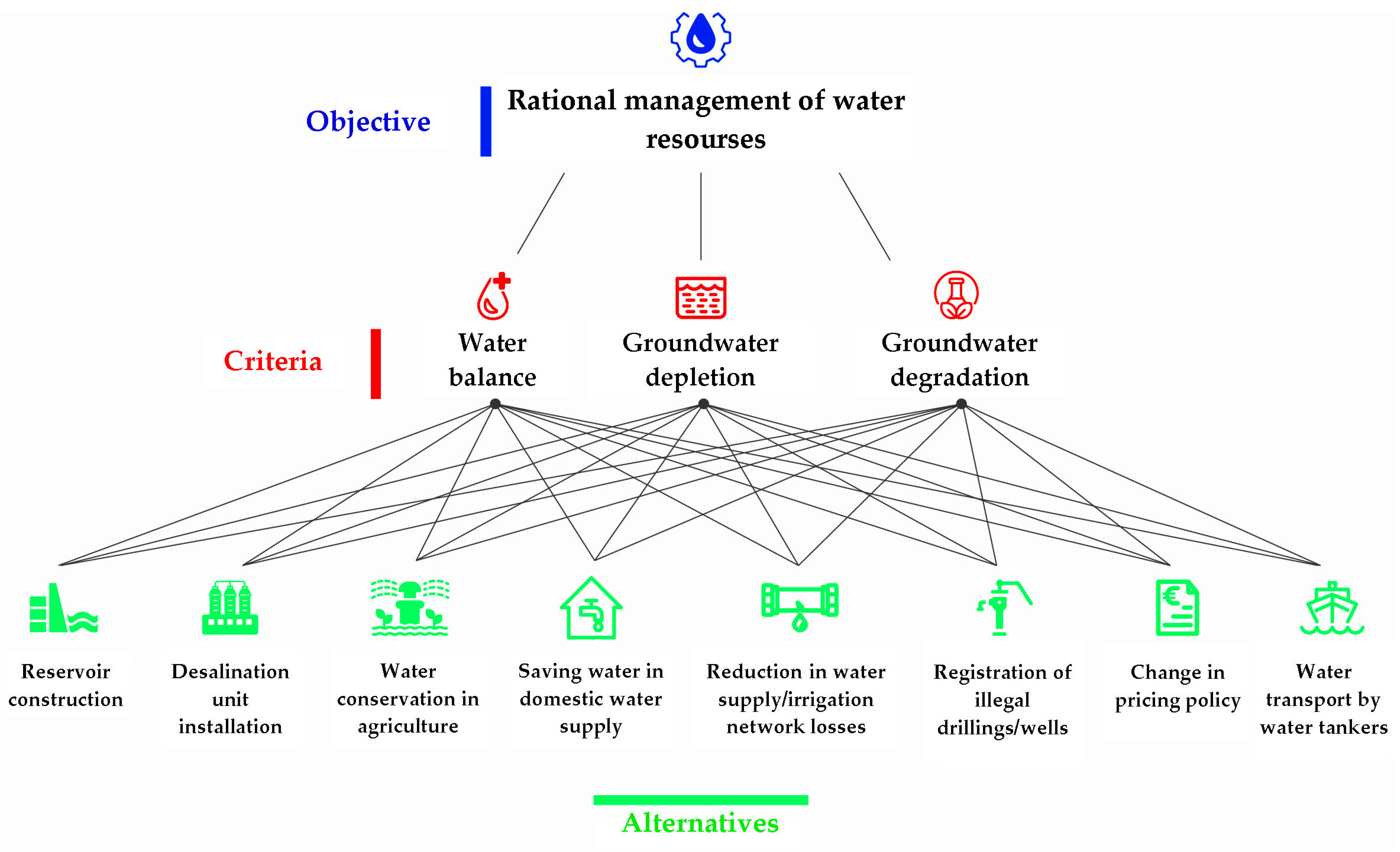
2.3. Multi-Criteria TOPSIS Analysis for Selecting the Best Water Management Practices on Each Island

The TOPSIS multi-criteria analysis method was used, which considered the different and conflicting objectives set to develop preferred relationships and the prioritization of the available options. As the complex issue of water resource management had to be addressed on each island, multi-criteria analysis was chosen, which collects, synthesizes, and processes data in such a way that by considering each criterion separately, it is able to provide the corresponding indicators for the overall performance of the options.
The currently used TOPSIS (Technique for Order of Preference by Similarity to Ideal Solution) method of Hwang and Yoon (1981) [44] was developed as an alternative to the ELECTRE class of methods. TOPSIS ranks alternatives by measuring their relative closeness to ideal and anti-ideal solutions by using Euclidean distance. In contrast, ELECTRE is an outranking method that compares alternatives pairwise, emphasizing dominance relations and decision thresholds. TOPSIS is a straightforward, intelligible, and user-friendly approach. The four main benefits of the method, which place it among the primary multi-criteria analysis techniques, are the following [45]:
  • Mathematical logic that represents the logic of the individual.
  • It simultaneously considers both the best and the worst alternatives.
  • A systematic and easily programmable computational procedure that can be easily processed in a spreadsheet.
  • The performance measures of all alternatives can be displayed on a polyhedron, at least in two dimensions.
Essentially, the TOPSIS methodology is partly based on utility theory, as it compares each alternative according to its performance and weights [53]. Furthermore, in a simulation comparison of eight methods of the same category, it was observed that TOPSIS had the fewest rank reversals [54]. TOPSIS belongs to the category of ELECTRE methods, which operate by identifying the distance between the ideal and anti-ideal solutions [55]. Undoubtedly, the closer they are to one another, the better. The steps for implementing the method are presented below.
1.
Assignment of scores to the criteria and alternatives. The decision table is designed, consisting of the scores of the alternatives to the evaluation criteria.
A = x 11 x 1 n x m 1 x m n ,
where A1, A2, …, Am, i = 1, 2, …, m are the alternatives; C1, C2, …, Cn, j = 1, 2, …, n, are the criteria; and xij is the performance of alternative Ai versus criterion Cj.
2.
Calculation of the normalized decision matrix. To calculate the normalized decision matrix R, each of its elements is calculated as follows:
r i j = x i j i = 1 m x i j 2
where rij is the normalized performance of alternative Ai versus criterion Cj.
3.
Calculation of the weighted normalized decision matrix. To calculate the weighted normalized decision matrix P, the normalized decision matrix R is multiplied by the weights of the criteria.
The weight vector W = [w1, w2, …, wn] consists of the individual weights wj for each criterion Cj that satisfies the constraint
j = 1 j = n w j = 1
The weighted normalized value pij can be calculated as follows:
p i j = w j · r i j
4.
Determination of positive and negative ideal solution vectors. To calculate the vectors representing the hypothetical positive ideal solution P+ (positive impact criteria) and the hypothetical negative ideal solution P− (negative impact criteria), i.e.,
P + = ( p 1 + , p 2 + ,   ,   p n + )
P = ( p 1 , p 2 ,   ,   p n )
the positive and negative ideal solutions for each criterion are calculated as
p 1 + = { max p i j , j J   ή   min p i j , j J }
p 1 = { min p i j , j J   ή   max p i j , j J }
where J represents the positive impact (benefit) criteria and J′ the negative impact (cost) criteria.
5.
Distance calculation. The distance of each alternative from the positive ideal solution is calculated as
S i + = j = 1 n ( p i j p j + ) 2
and from the negative ideal solution as
S i = j = 1 n ( p i j p j ) 2
6.
Calculation of relative proximity. The relative proximity Di to the positive ideal solution for each alternative Ai is calculated as
D i = S i S i + + S i
The ideal solution is, therefore, calculated for a specific problem, determined by the score for each criterion in relation to its ideal positive or negative value.
The solutions that are currently applied on the islands are the desalination of seawater, reservoir construction, boreholes/wells, and water transportation via ships. In this study, 8 different alternative solutions were evaluated under 3 different criteria. Questionnaires were completed in 2023 by 18 experts and decision makers (7 decision makers and 11 university professors), where they were asked to evaluate each criterion according to its importance. The questionnaire is presented in detail in the Supplementary Materials (File S1).
The criteria set, based on which each available option should be evaluated by the experts, were the following:
  • The long-term meeting of water demand (C1);
  • The management and prevention of groundwater depletion (C2);
  • The management and prevention of the degradation of aquifers (C3).
The management alternatives were determined based on a literature review and a survey of the existing situation for the study area. Specifically, the alternatives were the following:
  • Construction of new surface water storage projects (R1);
  • Installation of new plants (R2);
  • Water conservation in agriculture (R3);
  • Water conservation in domestic water supply (R4);
  • Reduction in water supply/irrigation network losses (R5);
  • Registration of illegal boreholes/wells (R6);
  • Change in pricing policy (R7);
  • Water transport by water tankers (R8).
Alternatives R1, R2, and R8 are scenarios for providing additional quantities of water to the water systems of the three islands, while the rest are scenarios for saving. Based on the above, an evaluation tree which is structured in three levels was constructed and proposed for use (Figure 6).
At the first level, there is the main objective. This is the rational management of water resources. At the second level, there are the three main criteria, which determine the management solution to be applied. Each alternative is considered in terms of the satisfaction of each criterion. Consequently, each criterion contributes to the final scoring of the available options based on the weight given to it.

3. Results

Based on the three criteria, the eight alternative solutions were evaluated by using questionnaires employing the TOPSIS methodology, as analyzed in the corresponding subsection in the methodology outlined above. The questionnaires were completed by experts and decision makers who were asked to evaluate the solutions according to the weight of each criterion. The responses of 18 questionnaires were collected.

3.1. Island of Mykonos

The results of the application of the method for Mykonos are presented in the following Table 4 and Table 5 and Figure 7. In Table 4, the scoring of the three criteria from the questionnaires for the eight (8) alternatives examined is given. Table 4 and Figure 7 show that Scenario R2 (installation of a desalination plant) has the highest score, with R3 (saving water in agriculture) second, and Scenario R8 (transporting water by ship) scores the worst, with respect to criterion C1 (water balance). Regarding the second criterion, C2 (depletion of groundwater), Scenario R3 (saving water in agriculture) has the highest score, followed by R2 (installation of a desalination plant), and the worst is Scenario R8 (transportation of water by ship). Finally, for the scores based on the third criterion, C3 (degradation of groundwater), R3 (saving water in agriculture) has the highest score, followed by Scenario R2 (installation of a desalination plant), and the worst is Scenario R8 (transportation of water by ship).
Table 5 shows the ranking of the scenarios, after processing with the TOPSIS methodology. Based on the relative proximity and the weights of the three criteria, it emerged that for Mykonos, the optimal solution is the installation of a desalination plant, followed by water saving in agriculture. The two most prevalent management practices are not surprising, since the island has exploited the two basins that could provide satisfactory quantities of water with storage projects, so the next alternative is a new desalination plant from the supply point of view. From the savings point of view, despite the low agricultural activity on the island, the quantities required to maintain crops are equal to the water supply requirements, as presented in Table 5. Therefore, water saving in agriculture would have the potential to rationalize water management for the island. At the same time, other practices that could be beneficial are saving water in irrigation, reducing network losses, and recording illegal boreholes and wells. The change in water pricing is relatively low in the evaluation of its effectiveness as a practice. As it is obvious, the worst solution is the transport of water by ship, which is an unsustainable, high-cost, and environmentally detrimental solution.

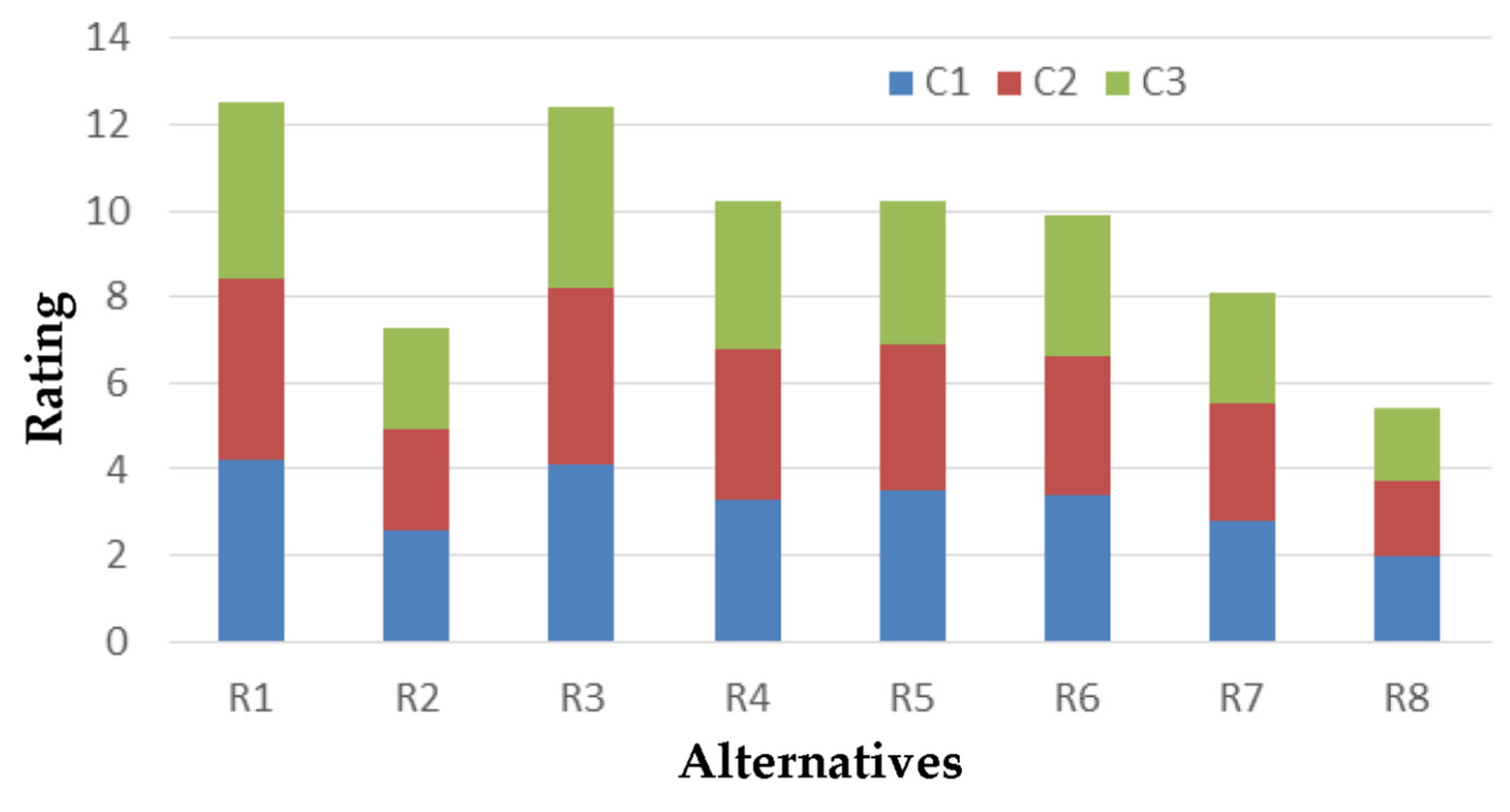
3.2. Island of Naxos

The results of the application of the method in the island of Naxos are presented in the following Table 6 and Table 7 and Figure 8. Table 6 and Figure 8 show that Scenario R1 (reservoir construction) obtained the highest score, with R3 (water saving in agriculture) in second place, and Scenario R8 (water transport by ship) is the worst, in terms of criteria C1 (water balance) and C2 (depletion of aquifers). Regarding the scores based on the third criterion, C3 (degradation of aquifers), Scenario R3 (water saving in agriculture) has the highest score, with R1 (reservoir construction) in second place, and Scenario R8 (water transport by ship) the worst.
Table 7 reveals the ranking of the scenarios, after processing with the TOPSIS method. Based on the relative proximity and the weights of the three criteria, it emerged that for Naxos, the optimal solution is the construction of reservoirs, followed by water saving in agriculture. Administratively, again, a supply solution is given with a storage project, while at the same time, a saving solution by the largest consumer (agriculture) is considered almost equally important. Water saving in water supply, the reduction in losses in the water supply and irrigation network, and the recording of illegal boreholes and wells are selected as co-subsidiary solutions. In addition, the change in water pricing is considered to be more helpful for the issue of rational management compared with the installation of a desalination plant. The worst possible solution, as in the case of the island of Mykonos, is the transport of water by ship.

3.3. Island of Kos

The results of the application of the method for Kos are presented in the following Table 8 and Table 9, and Figure 9. Table 8 presents that Scenarios R1 (reservoir construction) and R3 (water saving in agriculture) have the highest score, with Scenario R8 (water transport by ship) having the lowest score with respect to criterion C1 (water balance). Regarding the second criterion, C2 (depletion of aquifers), Scenarios R1 (reservoir construction) and R3 (water saving in agriculture) have the highest and equal scores, while Scenario R8 (water transport by ship) records the lowest score. Finally, from the evaluation based on the third criterion, C3 (degradation of aquifers), Scenario R3 (saving water in agriculture) shows the highest score, with R1 (construction of a reservoir) in second place, and Scenario R8 (transportation of water by ship) the lowest score.
In Table 9, the ranking of the scenarios based on the relative proximity and the weights of the three criteria are presented. For Kos, the optimal solution is water saving in agriculture, followed by the construction of reservoirs. Administratively, again, a saving solution by the largest consumer (agriculture) emerges, while at the same time, a solution to increasing the available quantity with a storage project is considered almost equally important. In parallel, appropriate combined practices are water saving in water supply, reducing losses in the water supply and irrigation network, and recording illegal boreholes and wells. Furthermore, the change in water pricing is considered to be more helpful for the issue of rational management, in relation to the installation of a desalination unit; however, this does not rank among the first preferences, in terms of its effectiveness. The worst solution, as for the other two islands, Mykonos and Naxos, is the transportation of water by ship.

4. Discussion

The results of this study, which were derived from a multi-criterion decision analysis (MCDA) employing the TOPSIS methodology, provide significant information for the most efficient water management plans for the islands of Mykonos, Naxos, and Kos. Three significant factors were considered in the analysis: groundwater quality degradation, aquifer depletion, and water balance. With notable differences and some similarities, the results show that the three islands have different preferences for various water management situations.
In Mykonos, the installation of a desalination plant (R2) was the alternative that achieved the best rating, followed by water conservation in agriculture (R3). Since Mykonos has already exhausted its natural water storage capacity, this result is more reasonable considering the island’s current water infrastructure. It is consequential to rely on desalination as the main source of water in order to ensure a steady and sustainable water supply. Despite the island’s small farming area, water conservation in agriculture becomes a significant additional option because of the high water requirements for irrigation. Water transportation by ship (R8) was the least preferred option, as it is not sustainable from economic and environmental perspectives. Reducing network losses and detecting illegal boreholes and wells are other helpful practices that might improve water efficiency even further. Previously published studies on other Mediterranean islands also highlighted the significance of desalination as an important water security approach in regions with restricted natural water resources [56,57,58,59]. However, in order to decrease the high energy costs and negative ecological impact of desalination, these studies also revealed the necessity of combining it with renewable energy sources.
Contrary to Mykonos, the best option for Naxos was to build reservoirs (R1), which was closely followed by reducing water usage in agriculture (R3). This means that proper water storage infrastructure would be very beneficial for Naxos, considering the larger agricultural sector. By reducing the potential of groundwater depletion, a reservoir would improve the island’s capability to control seasonal variations in water availability. Since agriculture uses a lot of water, conserving water in this sector also scored highly. As more usual water supply options were preferred over energy-consuming technologies, the desalination plant (R2) received a relatively low rating. The least popular alternative was water transportation by ship (R8). Reducing losses and conserving water through the water transportation network are other proposed practices that would support a more sustainable approach to water management. Giving priority to water conservation measures in agriculture is supported by previous studies conducted in Mediterranean agricultural regions. According to these studies, smart irrigation practices combined with infrastructure improvements could significantly improve water efficiency and reduce the need for outside sources [60,61,62,63].
Water conservation in agriculture (R3) was the best choice in the island of Kos, with reservoir construction coming in second (R1). This rating reveals how important agricultural water consumption is to the island and that conservation measures must be established. The need for increased water storage to maintain long-term sustainability is further supported by the high ranking of reservoir construction. As with the other islands, water transportation by ship (R8) was considered the least desirable possible alternative. The significance of infrastructure improvements is demonstrated by other medium-rated alternatives, such as minimizing network losses and identifying illegal boreholes and wells. Results from island studies in Greece and Spain indicate that the most beneficial effects have been achieved through a combined plan involving enhanced storage capacity, strict groundwater extraction regulations, and agricultural methods that save water [64,65,66].
The main limitations of this study were the lack of appropriate data, mainly for the available water from boreholes and the desalination units, and the absence of data regarding the water losses in the irrigation system. This lack of data posed a problem in calculating the available water and the water demand of the study area. Another limitation was the low number of questionnaires, which was attributed to the few local experts on water management resources.
The analysis revealed a number of common aspects, despite some variations in ratings among the islands. The significance of integrated water resource management is indicated by the need for conservation methods (reducing network losses and preserving water in agriculture) and storage solutions (reservoir construction and desalination plants). The results also show how economic measures—like adjustments to pricing policies—have been implemented poorly on all three islands. The results of this study are consistent with other studies on island water management, which indicate the need for a combined strategy, involving governmental measures, demand-side control, and infrastructure development [67,68,69]. Thorough planning, stakeholder involvement, and focus on communities are necessary for these projects to be effective.

5. Conclusions

It is important that the designed water policy that will be applied in the Aegean region focuses on the utilization of winter supplies by constructing mountain hydrological projects. Further, the rational use of water and the protection of water supplies by implementing strict measures of existing water resources, the education of farmers, and the improvement of water supply networks should be priorities. The reuse of water and the promotion of alternative forms of tourism should be examined by exploiting a longer period with a lower burden, aiming at improving the dispersion of tourism peak traffic in space and in time. Today, it is a necessity to adapt the management of mountainous watersheds to climate change, to avoid water scarcity phenomena and achieve the sustainable management of a region’s water resources. Regarding the research area, the construction of mountain hydrological projects should also be examined, such as riverbed gradient dams for temporary water storage and the enrichment of aquifers and alluvial fans of torrential streams (runoff retention projects). These projects will, on the one hand, increase the water resources of the area and, on the other hand, provide flood protection in lowland areas by reducing flood peaks. In the past, some runoff containment projects were carried out in the Apeirathos area in Naxos. Water policy in the research area should be developed considering factors such as high demand during a specific time period, significant groundwater salinization concerns, and restricted water resources.
However, a comprehensive water resource management proposal should include, in addition to technical interventions, individual actions, which will function as reinforcements during the implementation of the interventions. Therefore, plans to promote active participation of users in the rational use of water resources are necessary, as is the pricing policy of management bodies, which, if applied fairly and transparently, can act as an obstacle to the waste of available resources. As a result, it is evident that the successful and effective execution of the plans depends on the collaboration and involvement of all parties/stakeholders involved, including technocrats (engineers, geologists, agronomists, and foresters), the administrative authority, professional users, and individual consumers.

Supplementary Materials

The following supporting information can be downloaded at: https://www.mdpi.com/article/10.3390/cli13040078/s1, File S1: Expert and stakeholder questionnaire.

Author Contributions

Conceptualization, D.M. and E.S.; methodology, D.M., E.S. and A.K.; software, E.S.; validation, E.S.; formal analysis, E.S. and A.K.; investigation, E.S.; data curation, E.S. and A.K.; writing—original draft preparation, E.S. and A.K.; writing—review and editing, E.S., A.K. and D.M.; visualization, A.K.; supervision, D.M. All authors have read and agreed to the published version of the manuscript.

Funding

This research received no external funding.

Data Availability Statement

The data that support the findings of this study are available from the corresponding author upon reasonable request.

Conflicts of Interest

The authors declare no conflicts of interest.

References

  1. Shivakoti, B.R.; Lopez-Casero, F.; Kataoka, Y.; Shrestha, S. Methodological Framework. In An Integrated Approach for Planning Adaptation and Building Resilience of Smallholder Subsistence Livelihoods in Nepal; Institute for Global Environmental Strategies: Hayama, Japan, 2015. [Google Scholar]
  2. Tzanakakis, V.A.; Paranychianakis, N.V.; Angelakis, A.N. Water Supply and Water Scarcity. Water 2020, 12, 2347. [Google Scholar] [CrossRef]
  3. Zetland, D. The Role of Prices in Managing Water Scarcity. Water Secur. 2021, 12, 100081. [Google Scholar] [CrossRef]
  4. Liu, J.; Yang, H.; Gosling, S.N.; Kummu, M.; Flörke, M.; Pfister, S.; Hanasaki, N.; Wada, Y.; Zhang, X.; Zheng, C.; et al. Water Scarcity Assessments in the Past, Present, and Future. Earths Future 2017, 5, 545–559. [Google Scholar] [CrossRef] [PubMed]
  5. Tzioutzios, C.; Kastridis, A. Multi-Criteria Evaluation (MCE) Method for the Management of Woodland Plantations in Floodplain Areas. ISPRS Int. J. Geoinf. 2020, 9, 725. [Google Scholar] [CrossRef]
  6. Cinelli, M.; Kadziński, M.; Gonzalez, M.; Słowiński, R. How to Support the Application of Multiple Criteria Decision Analysis? Let Us Start with a Comprehensive Taxonomy. Omega 2020, 96, 102261. [Google Scholar] [CrossRef]
  7. Figueira, J.; Greco, S.; Ehrogott, M. Multiple Criteria Decision Analysis: State of the Art Surveys; Springer: New York, NY, USA, 2005; Volume 78, ISBN 978-0-387-23067-2. [Google Scholar]
  8. Gebre, S.L.; Cattrysse, D.; Van Orshoven, J. Multi-Criteria Decision-Making Methods to Address Water Allocation Problems: A Systematic Review. Water 2021, 13, 125. [Google Scholar] [CrossRef]
  9. García-Cascales, M.S.; Molina-García, A.; Sánchez-Lozano, J.M.; Mateo-Aroca, A.; Munier, N. Multi-Criteria Analysis Techniques to Enhance Sustainability of Water Pumping Irrigation. Energy Rep. 2021, 7, 4623–4632. [Google Scholar] [CrossRef]
  10. Polatidis, H.; Haralambopoulos, D.A.; Munda, G.; Vreeker, R. Selecting an Appropriate Multi-Criteria Decision Analysis Technique for Renewable Energy Planning. Energy Sources Part B Econ. Plan. Policy 2006, 1, 181–193. [Google Scholar] [CrossRef]
  11. Wood, M. The Pros and Cons of Using Pros and Cons for Multi-Criteria Evaluation and Decision Making. SSRN Electron. J. 2009, 1545189. [Google Scholar] [CrossRef]
  12. Dodgson, J.S.; Spackman, M.; Pearman, A.; Phillips, L.D. Multi-Criteria Analysis: A Manual; Economic History Working Papers; London School of Economics and Political Science, Department of Economic History: London, UK, 2009. [Google Scholar]
  13. Behzadian, M.; Khanmohammadi Otaghsara, S.; Yazdani, M.; Ignatius, J. A State-of the-Art Survey of TOPSIS Applications. Expert Syst. Appl. 2012, 39, 13051–13069. [Google Scholar] [CrossRef]
  14. Zyoud, S.H.; Fuchs-Hanusch, D. A Bibliometric-Based Survey on AHP and TOPSIS Techniques. Expert Syst. Appl. 2017, 78, 158–181. [Google Scholar] [CrossRef]
  15. Dunning, D.J.; Ross, Q.E.; Merkhofer, M.W. Multiattribute Utility Analysis for Addressing Section 316(b) of the Clean Water Act. Environ. Sci. Policy 2000, 3, 7–14. [Google Scholar] [CrossRef]
  16. Pohekar, S.D.; Ramachandran, M. Application of Multi-Criteria Decision Making to Sustainable Energy Planning—A Review. Renew. Sustain. Energy Rev. 2004, 8, 365–381. [Google Scholar] [CrossRef]
  17. Singh, B.J.; Chakraborty, A.; Sehgal, R. A Systematic Review of Industrial Wastewater Management: Evaluating Challenges and Enablers. J. Environ. Manag. 2023, 348, 119230. [Google Scholar] [CrossRef]
  18. Cosgrove, W.J.; Loucks, D.P. Water Management: Current and Future Challenges and Research Directions. Water Resour. Res. 2015, 51, 4823–4839. [Google Scholar] [CrossRef]
  19. Karnib, A. An Approach to Elaborate Priority Preorders of Water Resources Projects Based on Multi-Criteria Evaluation and Fuzzy Sets Analysis. Water Resour. Manag. 2004, 18, 13–33. [Google Scholar] [CrossRef]
  20. Ekmekcioğlu, Ö.; Koc, K.; Dabanli, I.; Deniz, A. Prioritizing Urban Water Scarcity Mitigation Strategies Based on Hybrid Multi-Criteria Decision Approach under Fuzzy Environment. Sustain. Cities Soc. 2022, 87, 104195. [Google Scholar] [CrossRef]
  21. Freitas, A.H.A.; Magrini, A. Multi-Criteria Decision-Making to Support Sustainable Water Management in a Mining Complex in Brazil. J. Clean. Prod. 2013, 47, 118–128. [Google Scholar] [CrossRef]
  22. Kumar, V.; Del Vasto-Terrientes, L.; Valls, A.; Schuhmacher, M. Adaptation Strategies for Water Supply Management in a Drought Prone Mediterranean River Basin: Application of Outranking Method. Sci. Total Environ. 2016, 540, 344–357. [Google Scholar] [CrossRef]
  23. Kazakis, N.; Spiliotis, M.; Voudouris, K.; Pliakas, F.-K.; Papadopoulos, B. A Fuzzy Multicriteria Categorization of the GALDIT Method to Assess Seawater Intrusion Vulnerability of Coastal Aquifers. Sci. Total Environ. 2018, 621, 524–534. [Google Scholar] [CrossRef]
  24. Rodríguez-Sinobas, L.; Zubelzu, S.; Perales-Momparler, S.; Canogar, S. Techniques and Criteria for Sustainable Urban Stormwater Management. The Case Study of Valdebebas (Madrid, Spain). J. Clean. Prod. 2018, 172, 402–416. [Google Scholar] [CrossRef]
  25. Comino, E.; Bottero, M.; Pomarico, S.; Rosso, M. The Combined Use of Spatial Multicriteria Evaluation and Stakeholders Analysis for Supporting the Ecological Planning of a River Basin. Land Use Policy 2016, 58, 183–195. [Google Scholar] [CrossRef]
  26. Manfreda, S.; Di Leo, M.; Sole, A. Detection of Flood-Prone Areas Using Digital Elevation Models. J. Hydrol. Eng. 2011, 16, 781–790. [Google Scholar] [CrossRef]
  27. Radmehr, A.; Araghinejad, S. Flood Vulnerability Analysis by Fuzzy Spatial Multi Criteria Decision Making. Water Resour. Manag. 2015, 29, 4427–4445. [Google Scholar] [CrossRef]
  28. Tang, Z.; Zhou, Y.; Yu, H.; Gu, Y.; Liu, T. Developing an Interactive Mobile Volunteered Geographic Information Platform to Integrate Environmental Big Data and Citizen Science in Urban Management. In Seeing Cities Through Big Data; Springer: Berlin/Heidelberg, Germany, 2017; pp. 65–81. [Google Scholar]
  29. Tehrany, M.S.; Pradhan, B.; Jebur, M.N. Flood Susceptibility Mapping Using a Novel Ensemble Weights-of-Evidence and Support Vector Machine Models in GIS. J. Hydrol. 2014, 512, 332–343. [Google Scholar] [CrossRef]
  30. Papaioannou, G.; Vasiliades, L.; Loukas, A. Multi-Criteria Analysis Framework for Potential Flood Prone Areas Mapping. Water Resour. Manag. 2015, 29, 399–418. [Google Scholar] [CrossRef]
  31. Park, S.; Choi, C.; Kim, B.; Kim, J. Landslide Susceptibility Mapping Using Frequency Ratio, Analytic Hierarchy Process, Logistic Regression, and Artificial Neural Network Methods at the Inje Area, Korea. Environ. Earth Sci. 2013, 68, 1443–1464. [Google Scholar] [CrossRef]
  32. Khosravi, P.; Rezvani, A.; Wiewiora, A. The Impact of Technology on Older Adults’ Social Isolation. Comput. Hum. Behav. 2016, 63, 594–603. [Google Scholar] [CrossRef]
  33. Kubal, C.; Haase, D.; Meyer, V.; Scheuer, S. Integrated Urban Flood Risk Assessment—Adapting a Multicriteria Approach to a City. Nat. Hazards Earth Syst. Sci. 2009, 9, 1881–1895. [Google Scholar] [CrossRef]
  34. Kourgialas, N.N.; Karatzas, G.P. A National Scale Flood Hazard Mapping Methodology: The Case of Greece—Protection and Adaptation Policy Approaches. Sci. Total Environ. 2017, 601–602, 441–452. [Google Scholar] [CrossRef]
  35. Kourgialas, N.N.; Karatzas, G.P. Flood Management and a GIS Modelling Method to Assess Flood-Hazard Areas—A Case Study. Hydrol. Sci. J. 2011, 56, 212–225. [Google Scholar] [CrossRef]
  36. Kastridis, A.; Margiorou, S.; Sapountzis, M. Check-Dams and Silt Fences: Cost-Effective Methods to Monitor Soil Erosion under Various Disturbances in Forest Ecosystems. Land 2022, 11, 2129. [Google Scholar] [CrossRef]
  37. Hajkowicz, S.; Collins, K. A Review of Multiple Criteria Analysis for Water Resource Planning and Management. Water Resour. Manag. 2007, 21, 1553–1566. [Google Scholar] [CrossRef]
  38. Steuer, R.E.; Na, P. Multiple Criteria Decision Making Combined with Finance: A Categorized Bibliographic Study. Eur. J. Oper. Res. 2003, 150, 496–515. [Google Scholar] [CrossRef]
  39. Cohon, J.L.; Marks, D.H. A Review and Evaluation of Multiobjective Programing Techniques. Water Resour. Res. 1975, 11, 208–220. [Google Scholar] [CrossRef]
  40. Masi, M.; Arrighi, C.; Piragino, F.; Castelli, F. Participatory Multi-Criteria Decision Making for Optimal Siting of Multipurpose Artificial Reservoirs. J. Environ. Manag. 2024, 370, 122904. [Google Scholar] [CrossRef]
  41. Alamanos, A.; Mylopoulos, N.; Loukas, A.; Gaitanaros, D. An Integrated Multicriteria Analysis Tool for Evaluating Water Resource Management Strategies. Water 2018, 10, 1795. [Google Scholar] [CrossRef]
  42. Bellwood-Howard, I.; Thompson, J.; Shamsudduha, M.; Taylor, R.G.; Mosha, D.B.; Gebrezgi, G.; Tarimo, A.K.P.R.; Kashaigili, J.J.; Nazoumou, Y.; Tiékoura, O. A Multicriteria Analysis of Groundwater Development Pathways in Three River Basins in Sub-Saharan Africa. Environ. Sci. Policy 2022, 138, 26–43. [Google Scholar] [CrossRef]
  43. Kastridis, A.; Stathis, D. The Effect of Small Earth Dams and Reservoirs on Water Management in North Greece (Kerkini Municipality). Silva Balc. 2015, 16, 71–84. [Google Scholar]
  44. Hwang, C.-L.; Yoon, K. Methods for Multiple Attribute Decision Making. In Multiple Attribute Decision Making; Springer: Berlin/Heidelberg, Germany, 1981; pp. 58–191. [Google Scholar]
  45. Shih, H.-S.; Shyur, H.-J.; Lee, E.S. An Extension of TOPSIS for Group Decision Making. Math. Comput. Model. 2007, 45, 801–813. [Google Scholar] [CrossRef]
  46. Kim, G.; Park, C.S.; Yoon, K.P. Identifying Investment Opportunities for Advanced Manufacturing Systems with Comparative-Integrated Performance Measurement. Int. J. Prod. Econ. 1997, 50, 23–33. [Google Scholar] [CrossRef]
  47. Sun, X.; Guo, C.; Cui, J. Research on Evaluation Method of Water Resources Carrying Capacity Based on Improved TOPSIS Model. La Houille Blanche 2020, 106, 68–74. [Google Scholar] [CrossRef]
  48. Han, F.; Alkhawaji, R.N.; Shafieezadeh, M.M. Evaluating Sustainable Water Management Strategies Using TOPSIS and Fuzzy TOPSIS Methods. Appl. Water Sci. 2025, 15, 4. [Google Scholar] [CrossRef]
  49. Lv, B.; Liu, C.; Li, T.; Meng, F.; Fu, Q.; Ji, Y.; Hou, R. Evaluation of the Water Resource Carrying Capacity in Heilongjiang, Eastern China, Based on the Improved TOPSIS Model. Ecol. Indic. 2023, 150, 110208. [Google Scholar] [CrossRef]
  50. Stathi, E.; Kastridis, A.; Myronidis, D. Analysis of Hydrometeorological Trends and Drought Severity in Water-Demanding Mediterranean Islands under Climate Change Conditions. Climate 2023, 11, 106. [Google Scholar] [CrossRef]
  51. Stathi, E.; Kastridis, A.; Myronidis, D. Analysis of Hydrometeorological Characteristics and Water Demand in Semi-Arid Mediterranean Catchments under Water Deficit Conditions. Climate 2023, 11, 137. [Google Scholar] [CrossRef]
  52. EEA European Environment Agency. Corine Land Cover: Copenhagen, Denmark. 2018. Available online: https://land.copernicus.eu/en/products/corine-land-cover/clc2018 (accessed on 12 February 2025).
  53. Cheng, S.; Chan, C.W.; Huang, G.H. Using Multiple Criteria Decision Analysis for Supporting Decisions of Solid Waste Management. J. Environ. Sci. Health Part A 2002, 37, 975–990. [Google Scholar] [CrossRef]
  54. Zanakis, S.H.; Solomon, A.; Wishart, N.; Dublish, S. Multi-Attribute Decision Making: A Simulation Comparison of Select Methods. Eur. J. Oper. Res. 1998, 107, 507–529. [Google Scholar] [CrossRef]
  55. Yoon, K. A Reconciliation Among Discrete Compromise Solutions. J. Oper. Res. Soc. 1987, 38, 277–286. [Google Scholar] [CrossRef]
  56. Kyriakarakos, G.; Papadakis, G.; Karavitis, C.A. Renewable Energy Desalination for Island Communities: Status and Future Prospects in Greece. Sustainability 2022, 14, 8176. [Google Scholar] [CrossRef]
  57. Martínez-Alvarez, V.; Maestre-Valero, J.F.; González-Ortega, M.J.; Gallego-Elvira, B.; Martin-Gorriz, B. Characterization of the Agricultural Supply of Desalinated Seawater in Southeastern Spain. Water 2019, 11, 1233. [Google Scholar] [CrossRef]
  58. Mentis, D.; Karalis, G.; Zervos, A.; Howells, M.; Taliotis, C.; Bazilian, M.; Rogner, H. Desalination Using Renewable Energy Sources on the Arid Islands of South Aegean Sea. Energy 2016, 94, 262–272. [Google Scholar] [CrossRef]
  59. Trapanese, M.; Frazitta, V. Desalination in Small Islands: The Case Study of Lampedusa (Italy). In Proceedings of the OCEANS 2018 MTS/IEEE Charleston, Charleston, SC, USA, 22–25 October 2018; IEEE: New York, NY, USA, 2018; pp. 1–7. [Google Scholar]
  60. Chartzoulakis, K.; Bertaki, M. Sustainable Water Management in Agriculture under Climate Change. Agric. Agric. Sci. Procedia 2015, 4, 88–98. [Google Scholar] [CrossRef]
  61. Aguilera, E.; Díaz-Gaona, C.; García-Laureano, R.; Reyes-Palomo, C.; Guzmán, G.I.; Ortolani, L.; Sánchez-Rodríguez, M.; Rodríguez-Estévez, V. Agroecology for Adaptation to Climate Change and Resource Depletion in the Mediterranean Region. A Review. Agric. Syst. 2020, 181, 102809. [Google Scholar] [CrossRef]
  62. Zucaro, R.; Baralla, S.; Arzeni, A.; Bodini, A.; Ciaravino, R.; Salato, N.; Chinnici, P.; Fasolino, N.G.; Pellegrini, E.; Sarzotti, E.; et al. Integrating Irrigation Decision Support Systems for Efficient Water Use: A Case Study on Mediterranean Agriculture. Land 2024, 14, 5. [Google Scholar] [CrossRef]
  63. Vidal, A. Case Studies on Water Conservation in the Mediterranean Region; Food & Agriculture Organization: Rome, Italy, 2001. [Google Scholar]
  64. Tzanakakis, V.; Angelakis, A.; Paranychianakis, N.; Dialynas, Y.; Tchobanoglous, G. Challenges and Opportunities for Sustainable Management of Water Resources in the Island of Crete, Greece. Water 2020, 12, 1538. [Google Scholar] [CrossRef]
  65. Gikas, P.; Tchobanoglous, G. Sustainable Use of Water in the Aegean Islands. J. Environ. Manag. 2009, 90, 2601–2611. [Google Scholar] [CrossRef]
  66. Chartzoulakis, K. Water Resources Management in the Island of Crete, Greece, with Emphasis on the Agricultural Use. Water Policy 2001, 3, 193–205. [Google Scholar] [CrossRef]
  67. Iglesias, A.; Garrote, L.; Diz, A.; Schlickenrieder, J.; Martin-Carrasco, F. Re-Thinking Water Policy Priorities in the Mediterranean Region in View of Climate Change. Environ. Sci. Policy 2011, 14, 744–757. [Google Scholar] [CrossRef]
  68. Donta, A.A.; Lange, M.A. Water Management on Mediterranean Islands: Pressure, Recommended Policy and Management Options. In Coping with Water Deficiency; Springer: Berlin/Heidelberg, Germany, 2008; pp. 11–44. [Google Scholar]
  69. Lebu, S.; Lee, A.; Salzberg, A.; Bauza, V. Adaptive Strategies to Enhance Water Security and Resilience in Low- and Middle-Income Countries: A Critical Review. Sci. Total Environ. 2024, 925, 171520. [Google Scholar] [CrossRef]
Figure 1. (A) The locations of the three islands within the Aegean Sea; islands of (B) Kos, (C) Mykonos, and (D) Naxos.
Climate 13 00078 g001aClimate 13 00078 g001b
Figure 2. Population changes in the study area (islands of Mykonos, Naxos, and Kos).
Climate 13 00078 g002
Figure 3. Schematic presentation of water system of Mykonos. Gray lines with numbers depict catchments of the island.
Climate 13 00078 g003
Figure 4. Schematic presentation of water system of Naxos. Gray lines with numbers depict catchments of the island.
Climate 13 00078 g004
Figure 5. Schematic presentation of water system of Kos. Gray lines with numbers depict catchments of the island.
Climate 13 00078 g005
Figure 6. Schematic representation of TOPSIS multi-criteria analysis.
Climate 13 00078 g006
Figure 7. The ranking of alternatives by experts using the TOPSIS method in Mykonos.
Climate 13 00078 g007
Figure 8. The ranking of alternatives by experts using the TOPSIS method in Naxos.
Climate 13 00078 g008
Figure 9. The ranking of alternatives by experts using the TOPSIS method in Kos.
Climate 13 00078 g009
Table 1. Water supply and demand in Mykonos.
Available WaterAmount (m3)DemandAmount (m3)
Dams and reservoirs790,000Settlements999,500
650,000Tourism522,000
Groundwater200,000Irrigation1,401,000
Livestock39,000
5 and 2 portable desalination unitsNo available dataIndustry123,000
Total1,640,000Total3,084,500
Table 2. Water supply and demand in Naxos.
Available WaterAmount (m3)DemandAmount (m3)
Dams and reservoirs1,467,000Settlements1,600,000
570,000Tourism400,000
Springs3,000,000Irrigation8,000,000
GroundwaterNo available dataLivestock525,000
Small industry150,000
Total5,037,000 10,675,000
Table 3. Water supply and demand in Kos.
Available WaterAmount (m3)DemandAmount (m3)
Dams and reservoirs342,000Settlements3,800,000
225,000Tourism700,000
GroundwaterIrrigation9,500,000
Springs3,000,000Livestock520,000
Small industry220,000
Total3,567,000 14,740,000
Table 4. Rating of alternatives for Mykonos from the questionnaires.
AlternativesCriteria
C1. Water BalanceC2.
Depletion of Aquifers
C3.
Deterioration of Aquifers
R1. Construction of a reservoir2.82.82.7
R2. Installation of a desalination plant4.33.94.1
R3. Saving water in agriculture4.14.14.2
R4. Saving water in water supply3.33.53.4
R5. Reducing network losses3.53.43.3
R6. Recording illegal boreholes/wells3.43.23.3
R7. Changing the pricing policy2.82.72.6
R8. Transporting water by ship2.01.71.7
Criterion weights0.40.350.25
Table 5. TOPSIS analysis results for Mykonos.
AlternativesRelative ProximityRankingOrder of Importance
R1. Construction of a reservoir0.41136
R2. Installation of a desalination plant0.96581
R3. Saving water in agriculture0.93872
R4. Saving water in water supply0.66954
R5. Reducing network losses0.68663
R6. Recording illegal boreholes/wells0.62745
R7. Changing pricing policy0.38427
R8. Transporting water by ship0.00018
Table 6. Rating of alternatives for Naxos from the questionnaires.
AlternativesCriteria
C1. Water BalanceC2.
Depletion of Aquifers
C3.
Deterioration of Aquifers
R1. Construction of a reservoir4,24.24.1
R2. Installation of a desalination plant2.62.32.4
R3. Saving water in agriculture4.14.14.2
R4. Saving water in water supply3.33.53.4
R5. Reducing network losses3.53.43.3
R6. Recording illegal boreholes/wells3.43.23.3
R7. Changing the pricing policy2.82.72.6
R8. Transporting water by ship2.01.71.7
Criterion weights0.40.350.25
Table 7. TOPSIS analysis results for Naxos.
AlternativesRelative ProximityRankingOrder of Importance
R1. Construction of a reservoir0.98081
R2. Installation of a desalination plant0.25627
R3. Saving water in agriculture0.94572
R4. Saving water in water supply0.66954
R5. Reducing network losses0.68363
R6. Recording illegal boreholes/wells0.62345
R7. Changing the pricing policy0.38236
R8. Transporting water by ship0.00018
Table 8. Rating of alternatives for Kos from questionnaires.
AlternativesCriteria
C1. Water BalanceC2.
Depletion of Aquifers
C3.
Deterioration of Aquifers
R1. Construction of a reservoir4.24.13.9
R2. Installation of a desalination plant2.62.32.4
R3. Saving water in agriculture4.14.14.2
R4. Saving water in water supply3.33.53.4
R5. Reducing network losses3.53.43.3
R6. Recording illegal boreholes/wells3.43.23.3
R7. Changing pricing policy2.82.72.6
R8. Transporting water by ship2.01.71.7
Criterion weights0.40.350.25
Table 9. TOPSIS analysis results for Kos.
AlternativesRelative ProximityRankingOrder of Importance
R1. Construction of a reservoir0.94972
R2. Installation of a desalination plant0.25127
R3. Saving water in agriculture0.96581
R4. Saving water in water supply0.68254
R5. Reducing network losses0.69663
R6. Recording illegal boreholes/wells0.63545
R7. Changing the pricing policy0.38936
R8. Transporting water by ship0.00018
Disclaimer/Publisher’s Note: The statements, opinions and data contained in all publications are solely those of the individual author(s) and contributor(s) and not of MDPI and/or the editor(s). MDPI and/or the editor(s) disclaim responsibility for any injury to people or property resulting from any ideas, methods, instructions or products referred to in the content.

