Article

Proposal of an Agricultural Vulnerability Stochastic Model for the Rural Population of the Northeastern Region of Brazil

by
Bruce Kelly da Nóbrega Silva
1,
Rafaela Lisboa Costa
2,
Fabrício Daniel dos Santos Silva
2,*,
Mário Henrique Guilherme dos Santos Vanderlei
2,
Helder José Farias da Silva
2,
Jório Bezerra Cabral Júnior
3,
Djailson Silva da Costa Júnior
1,
George Ulguim Pedra
4,
Aldrin Martin Pérez-Marin
1 and
Cláudio Moisés Santos e Silva
5
1
National Institute of the Semiarid, Campina Grande 58434-700, Brazil
2
Institute of Atmospheric Sciences, Federal University of Alagoas, Maceió 57072-900, Brazil
3
Institute of Geography, Development and Environment, Federal University of Alagoas, Maceió 57072-900, Brazil
4
National Institute for Space Research, São José dos Campos, São Paulo 12227-010, Brazil
5
Center for Exact and Earth Sciences, Department of Atmospheric and Climate Sciences, Federal University of Rio Grande do Norte, Natal 59078-970, Brazil
*
Author to whom correspondence should be addressed.
Climate 2023, 11(10), 211; https://doi.org/10.3390/cli11100211
Submission received: 6 September 2023 / Revised: 16 October 2023 / Accepted: 18 October 2023 / Published: 20 October 2023

Abstract

:
Agriculture is the world’s main economic activity. According to the Intergovernmental Panel on Climate Change, this activity is expected to be impacted by drought. In the Northeast region of Brazil (NEB), most agricultural activity is carried out by small rural communities. Local socio-economic data were analyzed using multivariate statistical techniques in this study to determine agricultural sensitivity to drought events (SeA) and agricultural vulnerability to drought extremes (VaED). The climate data used to develop the risk factor (Rdrought) were the drought indicator with the Standard Precipitation Index (SPI) and the average number of drought disasters from 1991 to 2012. Conditional probability theory was applied to determine agricultural vulnerability to drought extremes (VaED). Characterization of the risk of agricultural drought using the proposed methodology showed that the rainy season presents high risk values in the central region, covering areas of the states of Ceará, Piauí, Pernambuco and Rio Grande do Norte, as well as all areas of the semi-arid region. The risk ranged from high to medium. The results also indicated that part of the south of Bahia and the west of Pernambuco have areas of extreme agro-climatic sensitivity. Consequently, these states have an extreme degree of climate vulnerability during the region’s rainy season.

1. Introduction

According to the fifth assessment report of the Intergovernmental Panel on Climate Change (IPCC)—IPCC AR5 [1], vulnerability is defined as the tendency or predisposition of a system to be adversely affected, including a variety of concepts and elements such as sensitivity or susceptibility to damage, and a lack of capacity to adapt and deal with stressors.
The risk of climate change is not only a circumstance generated externally to the climate system that societies have to face. Rather, it is a result of complex interactions between societies, ecosystems and climate change risk.
Historically, the Brazilian Northeast (NEB) region has faced many difficulties in coping with the effects caused by long droughts, mainly associated with the El Niño Southern Oscillation phenomenon [2] and/or temperature anomalies on the sea surface in the tropical Atlantic Ocean [3]. Such droughts have affected thousands of people [4,5], causing many socio-economic impacts, such as a reduction in agricultural production [6], especially for small producers [7,8] and a reduction in energy production and water supply due to shortage of reservoirs [9]. Further impacts include health matters such as outbreaks of dengue fever and endemic problems associated with a lack or poor quality of water supply such as the presence of endoparasites [10].
In recent years, studies on the vulnerability of the NEB have focused on risk analysis, evaluation of effects and approaches to mitigate the damage caused by extreme weather events and climate vulnerability [11,12]. However, agriculture in the NEB is paramount for regional development, mainly for subsistence agriculture, a means of production that varies from one place to another.
In order to determine the degree of vulnerability of a certain area, researchers normally use a set of indicators or vulnerability indices that are estimated based on other indicators (e.g., human development index, population density, etc.). These indicators are useful to analyze trends and explore conceptual models with flexibility applicable at different spatial and temporal scales [13]. However, they are limited by a lack of information about the choice of variables and the rules applied to determine the vulnerability index for a particular region or community [14]. These limitations have led to the use of statistical tools to correlate crop vulnerability with drought, using socio-economic indicators as a means of identifying the factors that can make areas more vulnerable [15]. Examples of studies on climate vulnerability in agriculture include [8,13,15,16,17,18].
Identification of the vulnerability of a given population to climate events, or specifically to agricultural drought, requires a large amount of data with good spatial and temporal resolution, as well the use of climate or harvest forecast models [19]. The work of [20], a study conducted in Bulgaria, adopted statistical techniques to relate climate projections of precipitation and temperature to corn and wheat productivity. These authors used general circulation models (GCM) to create climatic scenarios and assess the impact on crop productivity.
Based on the problem presented above, the objective of this study is to analyze the agricultural vulnerability of the NEB to climatic extremes of precipitation (specifically drought). Therefore, the goal is to identify the areas in which the crops are more vulnerable to these events using social and climatic indicators. This study is simple and objective to attempt to aid managers in the confrontation of extreme drought-related events in the family farming sector.
The article is divided into Section 2, in which the methodology of the creation of the indicators of agricultural vulnerability is presented; Section 3, in which the partial results of the study are presented; and Section 4 which discusses the final considerations and difficulties met in the study.

2. Materials and Methods

2.1. Area of Study and Data

The NEB encompasses nine states of the Brazilian federation, covering an area of approximately 1.6 million km2 [21]. The NEB is in the equatorial zone, and thus presents a precipitation regime typical of this zone.
Two types of climates are predominant in the NEB: tropical and semi-arid. The tropical climate is classified as Af (without a dry season) and Aw (with a dry winter), and the semi-arid as As (with a dry summer) and BSh (a dry region with low altitudes) [22]. The semi-arid climate occurs in the endemic biome, Caatinga, which is found in all states of the NEB, with the largest portions located in the states of Rio Grande do Norte (61.2%) and Pernambuco (61.7%). The total annual precipitation in the semi-arid region of the NEB is usually less than 700 mm.
Due to the high temporal and spatial variability of precipitation in the NEB, some studies have sought to characterize extreme precipitation events. For example, [23] diagnosed an increase in amplitude and seasonality of precipitation in the autumn months when high precipitation intensity events occurred. On the other hand, [2] determined that in the central part of the NEB, the rainy period spans from December to May, and in the eastern portion, from March to July.
Daily precipitation data were obtained from 148 rain gauges from the hydroweb system of the Agência Nacional das Águas (ANA), a tool of the Sistema Nacional de Informações Sobre Recursos Hídricos (SNIRH), available at https://www.snirh.gov.br/hidroweb, accessed on 26 February 2023. These data were accumulated on a monthly scale and used in this study. The period analyzed was from 1 January 1979 to 31 December 2011. This database was also used by [23,24]. Figure 1 presents the study area and the hydro-meteorological stations used.

2.2. Methods

The concept of vulnerability presented by the IPCC AR5 states that vulnerability reflects a set of dangers, defined as potentially harmful physical events, to which a community can be exposed, mitigated by the community’s adaptive capacity, defined as the ability of the community to respond effectively to the risk. Therefore, an expression that can be initially used for the definition of vulnerability is presented in Equation (1).
V = f (H, S, AC)
where H is the danger factor, S is the sensitivity, and AC is the adaptive capacity.
In reality, Equation (1) is difficult to implement in regions such as the NEB because of the lack of data on local heterogeneity, mainly regarding biophysical and socio-economic factors of the family farming sector.
The main consequences of drought in the NEB are agricultural losses and water shortage for human and animal consumption. Through civil defense, city administrators determine a state of emergency through drought decrees, and federal resources are made available in order to counteract the effects of droughts. One of the most commonly used strategies to cope with drought in the region, supported by the federal resources above mentioned, is the distribution of water via tank trucks. Risk-related vulnerability is widely disseminated in the IPCC AR5 and cited by [25], and is calculated using the following expression:
R d r o u g h t = H × V
where H is the danger associated with a particular extreme event and V is the vulnerability. Risk (or exposure to drought) is calculated as follows:
R d r o u g h t = f ( S P I , D ) ( exp D M × log D )
In Equation (3), SPI is the Standardized Drought Index [26] calculated using monthly precipitation data from 1 January 1979 to 31 December 2011; DM is the drought magnitude and D is the average number of drought disasters per micro-region in the period between 1991 and 2012, as published by the Centro de Estudos e Pesquisas em Engenharia e Defesa Civil (CEPED) available on the site http://www.ceped.ufsc.br/, accessed on 26 February 2023. The SPI quantifies rainfall deficits or excesses on different time scales and is used to monitor the duration and intensity of an extreme drought event. Drought magnitude (DM) was determined in the rainy period according to the following equation proposed by [26]:
D M = j = 1 n S P I i j
In Equation (4), j is the initial month of the rainy period, which goes up to month n, and i is the year of the time series.
The communalities represent the portion of the variance that a variable shares with all the other variables considered, as well as the proportion of variance explained by the common factors.
To test the suitability of the factor model, Bartlett’s test of sphericity can be applied to test the null hypothesis that the variables are not correlated in the population. A high value of the test statistic favors rejection of the null hypothesis.
Also, the Kaiser–Meyer–Olkin (KMO) measure of sample adequacy compares the magnitudes of the observed correlation coefficients with the magnitudes of the partial correlation coefficients. Small KMO values indicate that the correlations between pairs of variables cannot be explained by other variables, indicating that the factor analysis is not adequate. Hypotheses:
H0. 
The population correlation matrix is an identity matrix, i.e., the variables are not correlated in the population.
H1. 
The population correlation matrix is not an identity matrix, i.e., the variables are correlated in the population.
Empirical Bayesian kriging was used as a geostatistical interpolation method for all the data obtained and mapped using the methodology described, as it has the advantage of automatically calculating the parameters of spatially distributed variables from adjacent values considered to be interdependent, and its semi-variogram makes it possible to quantitatively represent the variation of a phenomenon regionalized in space [27].

2.3. Determination of the Agricultural Sensitivity Factor SeA

To determine the agricultural sensitivity to extreme drought events (SeA) factor, the authors used the multivariate technique of factorial analysis (FA), proposed by [28], associated with the R software [29], aiming to reduce the number of variables through the creation of new variables with the variability of the original ones. Table 1 presents 50 variables that represent the agricultural sensitivity and adaptation capacity used in this research. These data pertain to the socio-economic characteristics of small, rural producers and were retrieved from the 2006 agricultural census of the Brazilian Institute of Geography and Statistics (IBGE), available from http://www.sidra.ibge.gov.br/, accessed on 26 February 2023. According to Hair Jr et al. (2000) [28], FA rests upon assumptions of multivariate normality and multicollinearity. Therefore, the following items must be evaluated: the matrix of factor loadings against variables; Bartlett’s sphericity test; communality greater than 0.5; the existence of a structure that unites the study variables.
The expression used to determine the SeA according to its sensitivity/susceptibility (S) and adaptation capability (AC) is described by the authors as:
S e A = f ( S , A C )

2.4. Calculation of Agricultural Vulnerability to Extreme Droughts (VaED)

Based on the agricultural sensitivity (SeA) factor and the risk associated with climatic extremes, the theorem of probability is used to determine vulnerability (VaED) using the conditional probability theorem [28], which states that the probability of an Rdrought event occurring given that another SeA event has occurred is given by the following:
P R d r o u g h t S e A = P ( R d r o u g h t S e A ) P S e A  
where the events correspond to: P ( R d r o u g h t ) probability of the drought event (risk), and P S e A the probability of the event being in an area sensitive to the event.
Assume that the events are independent, i.e., the occurrence of one does not affect the occurrence of the other. This implies that whether or not there is a greater risk of drought in a more sensitive area is not related to the probability of it being in that specific area. As the events are independent, the joint probability and occurrence of the events is given by the following equation:
V a E D = P R d r o u g h t S e A = P R d r o u g h t × P S e A

3. Results and Discussion

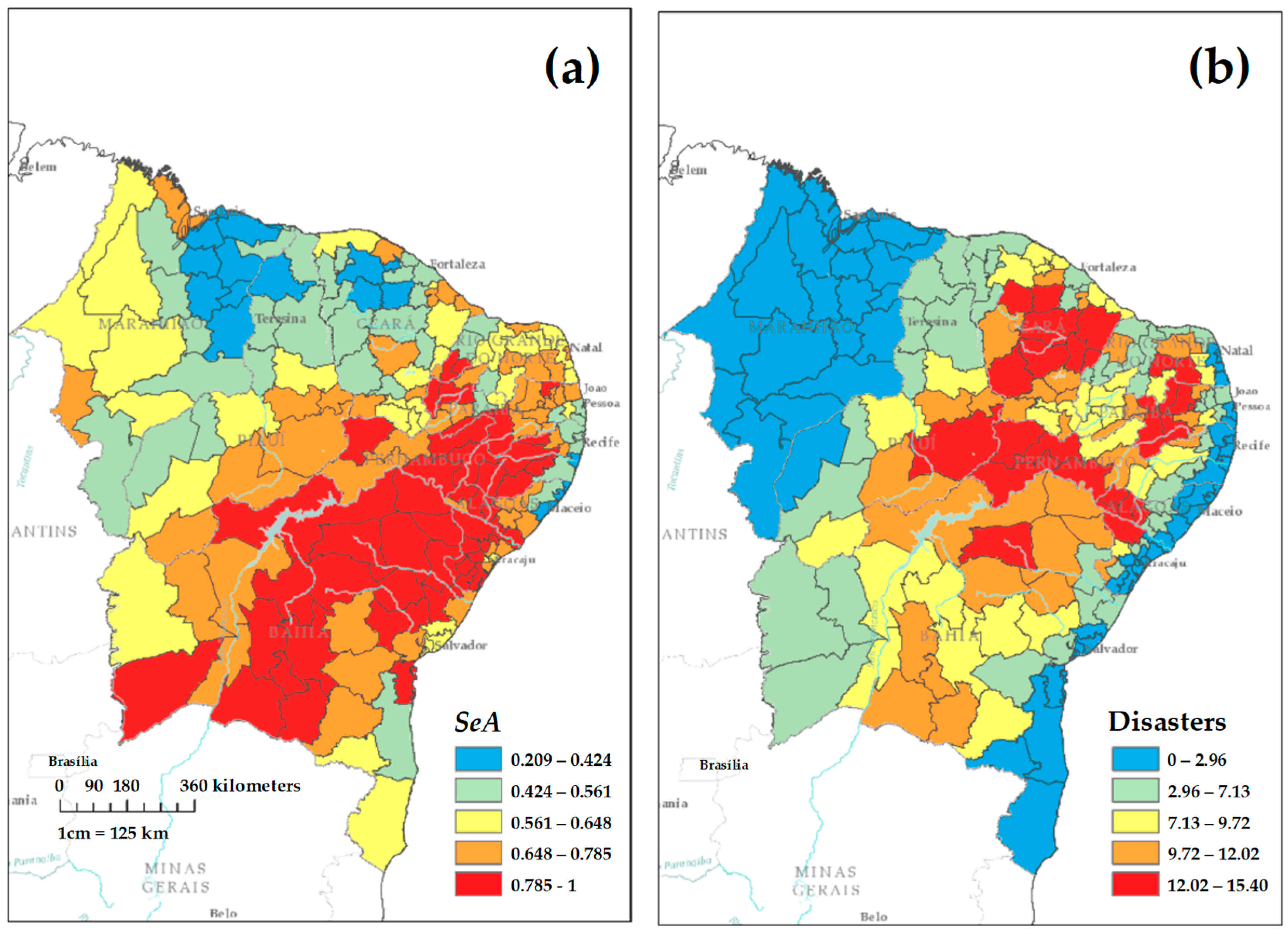
In Figure 2, the agricultural sensitivity component, drought extremes (SeA) and the spatial distribution of the data for drought disasters are displayed. The spatialization of the agricultural component sensitivity to dry events, obtained through the statistical multivariate technique factorial analysis (FA), is presented in Figure 2a. A high probability of SeA is observed in almost the entire NEB, mainly in the center-south and southeast areas, with values ranging from 0.709 to 1. However, the northwest part of the NEB presents the lowest values, ranging from 0.203 to 0.594.
Figure 2b shows the average occurrence of disasters over the 22 years of the study, segmented by micro-regions in the NEB. This represents the average number of disasters caused by drought that were notified and registered by CEPED. The micro-regions located in the center of the NEB recorded the highest averages, covering practically the entire semi-arid region, with values ranging from just over 7 to just over 15 disasters during the 22-year period analyzed. In contrast, in the East Coast and extreme West regions, average values are lower, ranging from 0 to approximately 3 disasters, on average, over these 22 years.
It must be highlighted in Figure 2 that although it has areas with a much greater sensitivity, when compared to disasters (Figure 2b), it is not the case that areas in which more disasters occur are more sensitive to them and vice versa. For example, in the southwest region of the NEB, more specifically in the southwest of Bahia, the authors observed the highest values in terms of the probability of high sensitivity/exposure, but in Figure 2b that same area has, on average, low values in terms of drought-related disasters.

3.1. Analysis of Risk Component and Factorial Analysis for the Sensitivity Component (SeA)

Table 2 presents the communality values that represent the proportion of variance for each variable included in the analysis and explained by the extracted factors. If this communality value is not greater than 0.5, it is recommended that the variable be excluded and the FA carried out again. It was observed that the variables with the smallest communality were s3, s11, ad2 and ad19.
Knowing that factor loadings are a fundamental part of FA, Table 3 describes the relationships between the observed variables (or indicators) and the underlying factors extracted during factor analysis. The loadings indicate the strength and direction of the relationship between the variable and each factor. It was observed that the first factor was highly correlated with the activity developed outside the agricultural zone, represented by the agribusiness variable (S15), which had a value of 0.930. For the research, many had values above 0.6, despite the fact that 0.4 was the recommended value [30].
Therefore, the other correlations presented in this factor were the variables: “does not know how to read or write” (ad5), non-governmental organization (ad13), “does not receive” (ad14), and planting level (ad19), whose values are 0.887; 0.894; 0.813 and 0.622, respectively. In this way, F1 is defined as risk generated by lack of training/qualification when managing costs/techniques. According to the indicator and variables selected, F2 is defined as educational level of the agricultural manager.
These two factors represent 48% of the data variance (Table 4). The low education level and lack of adequate training can cause damaging consequences for the population or community, in addition to the environmental damage. Waichman (2008) [31] mentioned that a lack of supervision in the use and sale of pesticides, along with a lack of training and a low education level are important factors that contribute to the risk of poisoning for small producers in the Amazon.
Therefore, the same logic was used in the other seven factors: F3—employability in agricultural establishments, F4—technical support offered by the government, F5—performance of cooperatives in the agricultural establishment, F6—investment level of the establishment, F7—manager of the establishment with some higher training, and F8—location of the establishments.
Table 4 presents the collected variances, the loads of each factor and the adequacy measurements of the factorial model. The p-value proves the null hypothesis H0: the proposed factorial model is suitable with 47.1% significance. The Kaiser–Meyer–Olklin (KMO) test ranges from 0 to 1 (the nearer to 1, the better the factorial model). A value of 0.774 obtained in this analysis, well above the value of 0.5 suggested by Hair Jr et al. (2000) [28], shows that there is an average correlation between the variables.
Finally, the Bartlett test showed that the factorial model is statistically significant, with a value of 2470.8. Therefore, it can be concluded that factorial analysis is suitable for the data obtained in this research, a value of 1254.56 and a KMO of 0.868, rendering the factorial model satisfactory, Figueiredo et al. (2010) [30]
Due to the fact that the precipitation stations do not cover all the micro-regions, as can be observed in Figure 1, there was a need to use an interpolation technique, specifically kriging, in order to obtain the agricultural risk to extreme drought events (Rdrought), using Equation (3), and presented in Figure 3b, as well as for the punctual evaluation of the SeA, Figure 3a.
The DM proposed in Equation (4) was calculated for the rainy season of the NEB, highlighting that for the selected stations, the rainy period was between January and April. It can be observed that the area presenting a medium to extreme risk covers almost the entire semi-arid region of the NEB, highlighting that the extreme areas are located in the most central area, covering part of the Pernambuco, Ceará and Piauí states as well as the extreme southwest of Bahia. The northern region of Ceará state must be highlighted, since during the period between December and February, the humidity convergence in the rainy season is much lower when compared to the dry season [23].
On the other hand, the disaster decree, often denominated by the media as a state of emergency, is a method that the local managers use to raise financial resources to mitigate their effects.
The factorial analysis, followed the procedure proposed by [8], was used to determine the SeA for the Rio Grande do Norte state. Unlike this research, the database used referred to the productivity of the most used crops in the NEB, thus not covering socio-economic characteristics of the producers as suggested by [7,11,17].

3.2. Agricultural Vulnerability to Drought Extremes

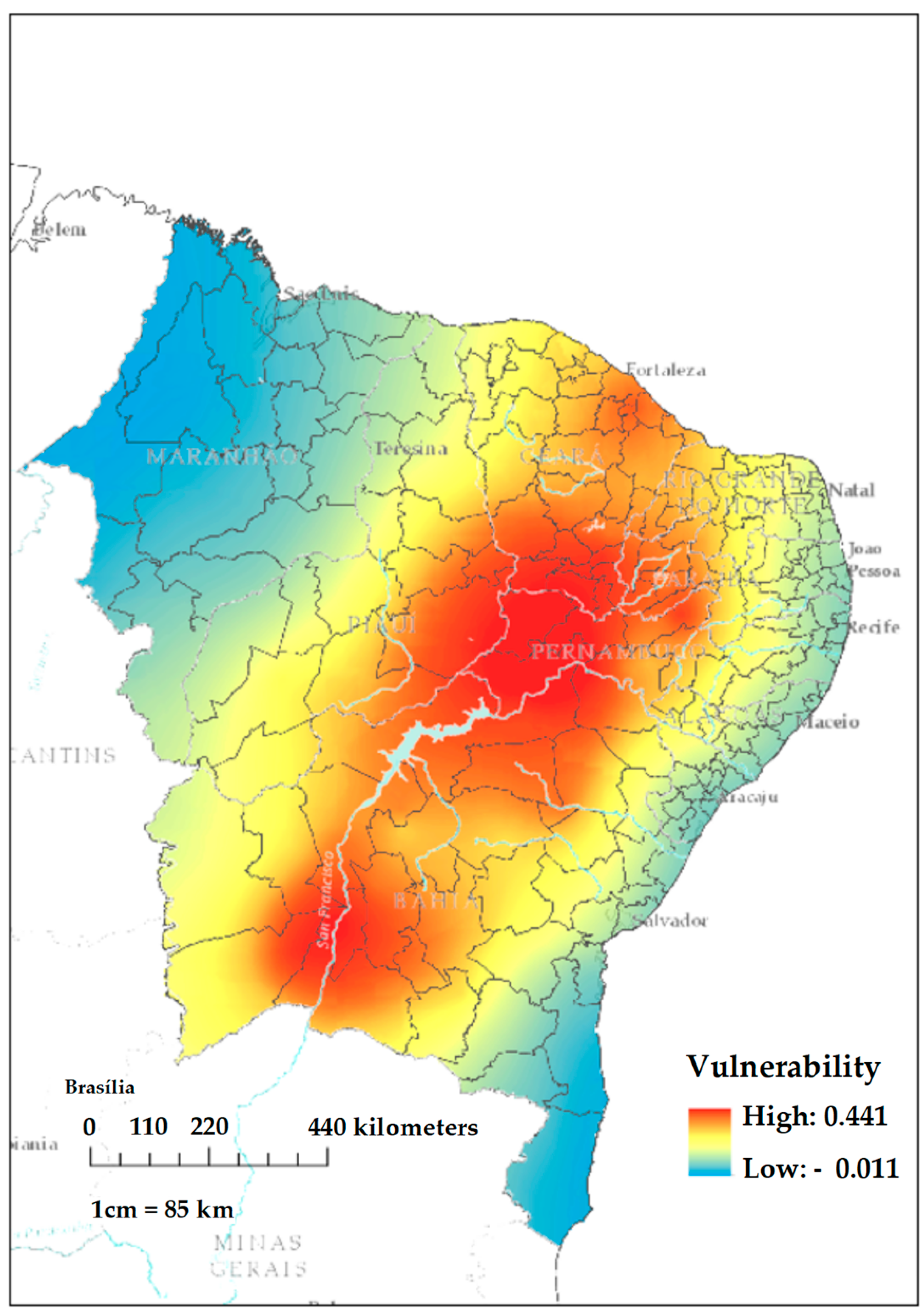
Figure 4 presents the VaED characterization for the NEB. Three regions of high VaED were observed: a larger one located in the center of the NEB, covering part of Pernambuco, Piauí, Ceará and Rio Grande do Norte states, and two minor ones in the southwest part of Bahia state and north Ceará. It also highlights the areas that produce grains, soybeans and corn in the southwest region of Bahia and those that produce fruit for exportation in the municipality of Petrolina, Pernambuco. Also, it is noticed that these areas are located in the San Francisco watershed, the largest reservoir of the NEB, except the northern nucleus in the State of Ceará.
This result corroborates with the work of [4,5] in that in its climatic projections for 2010–2040 and 2040–2070, using the indexes of Budyko dryness and UNEP (United Nations Environmet Programme), it identified areas of dryness or precipitation deficit, mainly in the location where the largest nucleus of VaED lies.
Also, the work of [5] can be used in the risk assessment, where the climatic projections of drought in the NEB are a result of the increase in seasonal droughts, the decrease in the length of the rainy period, and the increase in Indian summer temperatures, represented by the annual index of consecutive drought days (CDD). It was noticed that in one of the projections using RCP 2.6, 2011–2040 and 2041–2070, the southwest region of Bahia may have more than 22 CDDs and the precipitation did not exceed 0.1 mm/day.
Therefore, the importance of determining the VaED of an area is highlighted through the use of in locus observations and advanced statistical techniques, corroborating on the observation of climatic scenarios from the beginning of the study period and those that should take place in the next 30 years.

4. Conclusions

This pioneering study offers an in-depth approach to agricultural and farming areas susceptible to drought extremes in the Northeast of Brazil (NEB). In a context marked by the presence of a semi-arid climate and a significant population density, when compared to regions with similar climatic characteristics, the knowledge generated here proves to be of fundamental importance in guiding the formulation of public policies aimed at living with drought.
Our considerations, in summary, point to three crucial aspects:
(1)
The methodology adopted for calculating the risk of drought during the rainy season proved to be effective, not only because of its simplicity, but also because it provides results that are congruent with those found in the specialized literature.
(2)
The sensitivity and exposure of agriculture to drought (SeA) proved to be robust, since all the necessary validation steps, including the Kaiser–Meyer–Olkin (KMO) and Bartlett tests, were satisfactorily met. This establishes a solid basis for using the proposed model in future scientific research.
(3)
Finally, the vulnerability to drought extremes indicator (VaED) precisely delineated the areas that require special attention from the government, highlighting the central and southwestern regions of Bahia, as well as the entire semi-arid territory of the NEB. These areas have been identified as particularly critical in previous studies [4,5] due to future scenarios that point to an increase in water deficit.
(4)
Thus, this study represents a fundamental step in advancing knowledge about vulnerability to droughts in the region, providing valuable input for designing effective mitigation and adaptation strategies, which are essential for ensuring the resilience and sustainable development of the Brazilian Northeast in the face of these climatic challenges.

Author Contributions

Conceptualization, B.K.d.N.S. and C.M.S.e.S.; methodology, B.K.d.N.S., C.M.S.e.S., R.L.C., F.D.d.S.S. and A.M.P.-M.; software, B.K.d.N.S., C.M.S.e.S. and F.D.d.S.S.; validation, B.K.d.N.S., C.M.S.e.S., R.L.C. and F.D.d.S.S.; formal analysis, B.K.d.N.S., C.M.S.e.S., R.L.C., F.D.d.S.S. and A.M.P.-M.; data curation, B.K.d.N.S.; writing—original draft preparation, B.K.d.N.S. and C.M.S.e.S.; writing—review and editing, B.K.d.N.S., C.M.S.e.S., R.L.C., F.D.d.S.S. M.H.G.d.S.V., H.J.F.d.S., J.B.C.J., D.S.d.C.J., G.U.P. and A.M.P.-M.; visualization, B.K.d.N.S., C.M.S.e.S., R.L.C., F.D.d.S.S. and A.M.P.-M.; funding acquisition, R.L.C. and F.D.d.S.S. All authors have read and agreed to the published version of the manuscript.

Funding

We would like to thank the Conselho Nacional de Desenvolvimento Científico e Tecnológico (CNPq) for granting a postdoctoral fellowship to the first author through project 400014/2022-0. The third and fourth authors would like to especially thank the support of FAPEAL (Fundação de Amparo à Pesquisa de Alagoas), for supporting their project approved under FAPEAL Notice N°. 002/2022.

Data Availability Statement

The data used in manuscript are available by writing to the corresponding authors.

Acknowledgments

We would like to thank the institutions that provided the data and information used in this research free of charge.

Conflicts of Interest

The authors declare no conflict of interest.

References

  1. IPCC. Summary for policymakers. In Climate Change 2014: Impacts, Adaption, and Vulnerability. Part A: Global and Sectoral Aspects; Dokken, D.J., Field, C.B., Barros, V., Mach, M., Et, A., Eds.; Cambridge University Press: Cambridge, UK, 2014; pp. 1–32. Available online: http://ipcc-wg2.gov/AR5/images/uploads/WG2AR5_SPM_FINAL.pdf (accessed on 2 August 2023).
  2. Rao, V.B.; Franchito, S.H.; Santo, C.M.E.; Gan, M.A. An update on the rainfall characteristics of Brazil: Seasonal variations and trends in 1979–2011. Int. J. Climatol. 2015, 36, 291–302. [Google Scholar] [CrossRef]
  3. Da Rocha Júnior, R.L.; Pinto, D.D.C.; dos Santos Silva, F.D.; Gomes, H.B.; Gomes, H.B.; Costa, R.L.; Pereira, M.P.S.; Peña, M.; dos Santos Coelho, C.A.; Herdies, D.L. An Empirical Seasonal Rainfall Forecasting Model for the Northeast Region of Brazil. Water 2021, 13, 1613. [Google Scholar] [CrossRef]
  4. Marengo, J.A.; Bernasconi, M. Regional differences in aridity/drought conditions over Northeast Brazil: Present state and future projections. Clim. Chang. 2015, 129, 103–115. [Google Scholar] [CrossRef]
  5. Marengo, J.A.; Torres, R.R.; Alves, L.M. Drought in Northeast Brazil—Past, present, and future. Theor. Appl. Climatol. 2017, 129, 1189–1200. [Google Scholar] [CrossRef]
  6. Jiang, G.; Yu, F.; Zhao, Y. An analysis of vulnerability to agricultural drought in China using the expand grey relation analysis method. Procedia Eng. 2012, 28, 670–676. [Google Scholar]
  7. Kienberger, S.; Lang, S.; Zeil, P. Spatial vulnerability units—Expert-based spatial modelling of socio-economic vulnerability in the Salzach catchment, Austria. Nat. Hazards Earth Syst. Sci. 2009, 9, 767–778. [Google Scholar] [CrossRef]
  8. Silva, B.K.N.; Lucio, P.S. Indicator of Agriculture Vulnerability to Climatic Extremes. A Conceptual Model with Case Study for the Northeast Brazil. Atmos. Clim. Sci. 2014, 4, 334–345. [Google Scholar] [CrossRef]
  9. Brooks, N.; Adger, W.N.; Kelly, P.M. The determinants of vulnerability and adaptive capacity at the national level and the implications for adaptation. Glob. Environ. Chang. 2005, 15, 151–163. [Google Scholar] [CrossRef]
  10. Haines, A.; Kovats, R.S.; Campbell-Lendrum, D.; Corvalan, C. Climate change and human health: Impacts, vulnerability and public health. Public Health 2006, 120, 585–596. [Google Scholar] [CrossRef]
  11. Torres, R.R.; Lapola, D.M.; Marengo, J.A.; Lombardo, M.A. Socio-climatic hotspots in Brazil. Clim. Chang. 2012, 115, 597–609. [Google Scholar] [CrossRef]
  12. Darela Filho, J.P.; Lapola, D.M.; Torres, R.R.; Lemos, M.C. Socio-climatic hotspots in Brazil: How do changes driven by the new set of IPCC climatic projections affect their relevance for policy? Clim. Chang. 2016, 136, 413–425. [Google Scholar] [CrossRef]
  13. Gbetibouo, G.A.; Ringler, C.; Hassan, R. Vulnerability of the South African farming sector to climate change and variability: An indicator approach. Nat. Resour. Forum 2010, 34, 175–187. [Google Scholar] [CrossRef]
  14. Eakin, H.; Luers, A.L. Assessing the Vulnerability of Social-Environmental Systems. Annu. Rev. Environ. Resour. 2006, 31, 365–394. [Google Scholar] [CrossRef]
  15. Simelton, E.; Fraser, E.D.G.; Termansen, M.; Forster, P.M.; Dougill, A.J. Typologies of crop-drought vulnerability: An empirical analysis of the socio-economic factors that influence the sensitivity and resilience to drought of three major food crops in China (1961–2001). Environ. Sci. Policy 2009, 12, 438–452. [Google Scholar] [CrossRef]
  16. Wilhelmi, O.V. Assessing Vulnerability to Agricultural Drought: A Nebraska Case Study Assessing Vulnerability to Agricultural Drought: A Nebraska Case Study. Nat. Hazards 2002, 25, 37–58. [Google Scholar] [CrossRef]
  17. Luers, A.L.; Lobell, D.B.; Sklar, L.S.; Addams, C.L.; Matson, P.A. A method for quantifying vulnerability, applied to the agricultural system of the Yaqui Valley, Mexico. Glob. Environ. Chang. 2003, 13, 255–267. [Google Scholar] [CrossRef]
  18. Antwi-Agyei, P.; Fraser, E.D.G.; Dougill, A.J.; Stringer, L.C.; Simelton, E. Mapping the vulnerability of crop production to drought in Ghana using rainfall, yield and socioeconomic data. Appl. Geogr. 2012, 32, 324–334. [Google Scholar] [CrossRef]
  19. Popova, Z.; Ivanova, M.; Martins, D.; Pereira, L.S.; Doneva, K.; Alexandrov, V.; Kercheva, M. Vulnerability of Bulgarian agriculture to drought and climate variability with focus on rainfed maize systems. Nat. Hazards 2014, 74, 865–886. [Google Scholar] [CrossRef]
  20. Alexandrov, V.A.; Hoogenboom, G. The impact of climate variability and change on crop yield in Bulgaria. Agric. For. Meteorol. 2000, 104, 315–327. [Google Scholar] [CrossRef]
  21. Costa, R.L.; Gomes, H.B.; Pinto, D.D.C.; da Rocha Júnior, R.L.; dos Santos Silva, F.D.; Gomes, H.B.; da Silva, M.C.L.; Herdies, D.L. Gap Filling and Quality Control Applied to Meteorological Variables Measured in the Northeast Region of Brazil. Atmosphere 2021, 12, 1278. [Google Scholar] [CrossRef]
  22. Alvares, C.A.; Stape, J.L.; Sentelhas, P.C.; Gonçalves, J.L.D.M.; Sparovek, G. Köppen’s climate classification map for Brazil. Meteorol. Zeitschrift 2013, 22, 711–778. [Google Scholar] [CrossRef] [PubMed]
  23. Oliveira, P.T.; Santos e Silva, C.M.; Lima, K.C. Linear trend of occurrence and intensity of heavy rainfall events on Northeast Brazil. Atmos. Sci. Lett. 2014, 177, 172–177. [Google Scholar] [CrossRef]
  24. Oliveira, P.T.; Lima, K.C.; Santos e Silva, C.M. Synoptic environment associated with heavy rainfall events on the coastland of Northeast Brazil. Adv. Geosci. 2013, 35, 73–78. [Google Scholar] [CrossRef]
  25. Kienberger, S. The Integration of Land Use/Land cover Data within the Modelling of Socio-Economic Vulnerabilities; Centre for Geoinformatics, Salzburg University: Salzburg, Austria, 2010; pp. 205–214. [Google Scholar]
  26. Mckee, T.B.; Doesken, N.J.; Kleist, J. The Relationship of Drought Frequency and Duration to Time Scales. In Proceedings of the 8th Conference on Applied Climatology, Boston, MA, USA, 17–22 January 1993; Volume 17, pp. 179–183. [Google Scholar]
  27. Gribov, A.; Krivoruchko, K. Empirical Bayesian kriging implementation and usage. Sci. Total Environ. 2020, 722, 137290. [Google Scholar] [CrossRef] [PubMed]
  28. Hair, J.F., Jr.; Black, W.C.; Babin, B.J.; Anderson, R.E. Multivariate Data Analysis, 7th ed.; Prentice Hall: Upper Saddle River, NJ, USA, 2009; 761p. [Google Scholar]
  29. R Core Team. R: A Language and Environment for Statistical Computing; R Foundation for Statistical Computing: Vienna, Austria, 2013; ISBN 3-900051-07-0. Available online: http://www.r-project.org/3-900051-07-0 (accessed on 2 August 2023).
  30. Figueiredo, D.B.F.; Silva, J.A.J. Visão além do alcance: Uma introdução à análise fatorial. Opinião Pública 2010, 16, 160–185. [Google Scholar] [CrossRef]
  31. Waichman, A.V. Uma proposta de avaliação integrada de risco do uso de agrotóxicos no estado do Amazonas, Brasil. Acta Amaz. 2008, 38, 45–50. [Google Scholar] [CrossRef]
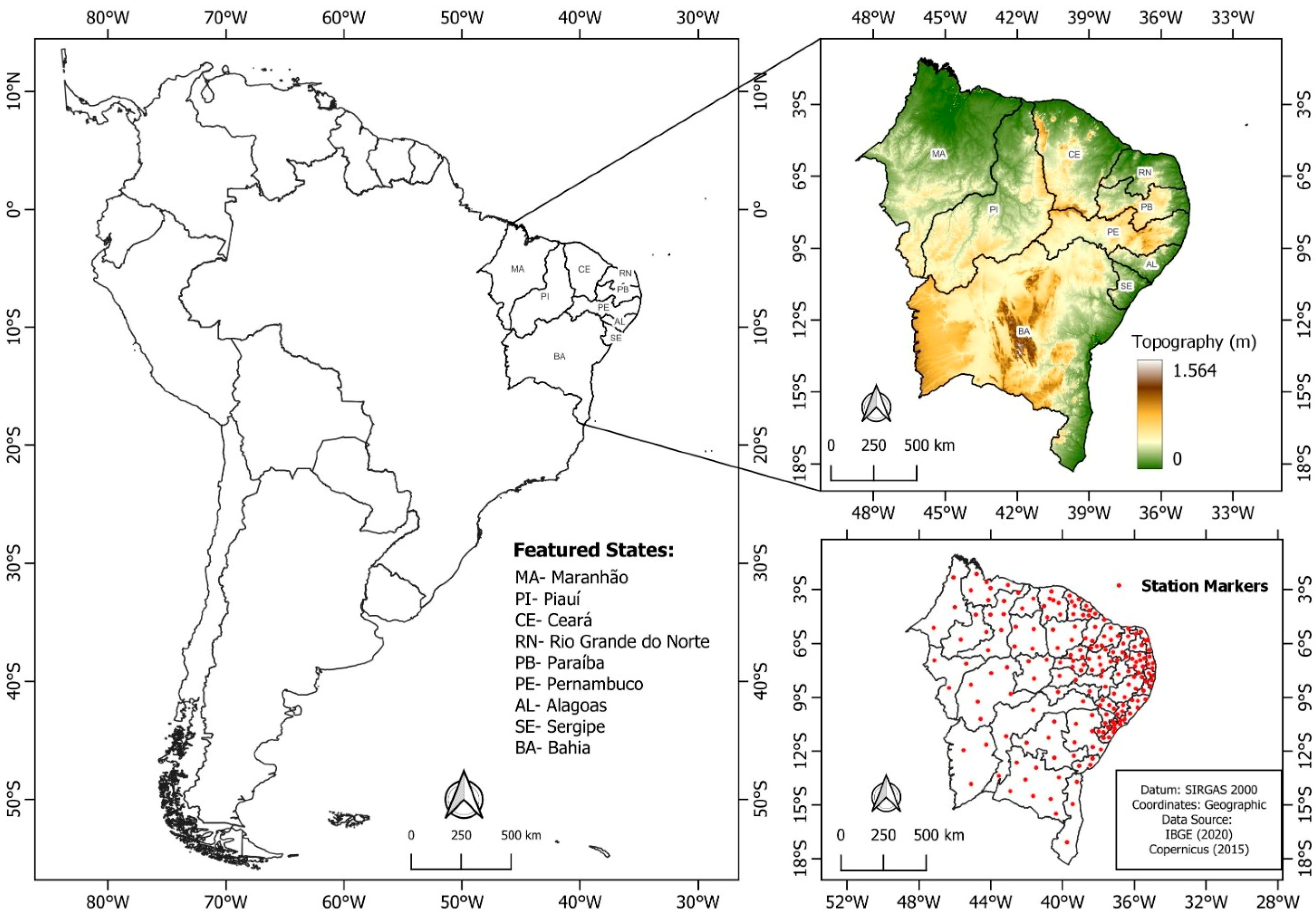
Figure 1. Area of study highlighting the political division of the region into meso-regions and hydro-meteorological stations (red dots) of the ANA.
Climate 11 00211 g001
Figure 2. (a) Spatialization of the agricultural component sensitivity/exposure to extreme drought events by NEB micro-regions, and (b) average values of drought disasters catalogued by CEPED in the period 1991–2012 (22 years).
Climate 11 00211 g002
Figure 3. (a) Agricultural sensitivity/exposure to extreme drought (SeA) and (b) risk of drought in the rainy quarter in the NEB based on monthly precipitation data in the period 1979–2011.
Climate 11 00211 g003
Figure 4. Characterization of agricultural vulnerability and drought extremes for the Northeast of Brazil.
Climate 11 00211 g004
Table 1. Variables used in the research.
ComponentIndicatorVariables
SensitivityLand usage in the establishmentsPermanent plantation (s1)Temporary plantation (s2)Natural pasture (s3)Forests that are areas of preservation or legal reserve (s4)Forests (permanent preservation area and in forest-agricultural systems). (s5)Degraded land (eroded, deserted, salinized, etc.) (s6)
Workers from agricultural establishmentsNumber of workers at the establishments (s7)
Production valueAnimal (s8)Vegetable (s9)Pressing vegetable-plantations (s10)Temporary vegetable-plantations (s11)Vegetable-horticulture (s12)Vegetable—vegetable extraction (s13)Agribusiness (s14)
Activity located out of the placeLivestock (s15)Non-livestock (s16)No activity (s17)
Adaptation CapacityTechnical knowledge of the person in chargeElementary education (1°grade) (ad1)Complete secondary school (agro-technical) (ad2)Complete secondary school (ad3)Other type of higher education (ad4)Does not know how to write and read (ad5)
Technical knowledge receivedOccasionally (ad6)Regularly (ad7)No (ad8)
Agent responsible for the technical guidance Government (federal, state or local) (ad9)Cooperatives (ad10)Private companies (ad11)Non-governmental organizations (NGO) (ad12)Non-applicable (ad13)
Degree of investment in the agricultural establishmentNumber of establishments that invested (ad14)Value of the investment (ad15)
Financial agent responsible for the loan Banks (ad16)Credit cooperatives (ad17)Nongovernmental organization (ONG) (ad18)
Agricultural technique Leveled planting (ad19)Crop rotation (ad20)Use of plantations to reform and/or renew and/or restore pastures (ad21)Fires (ad22)Protection/conservation of hillsides (ad23)
Electric powerSolar energy (ad24)Wind power (ad25)Burn of fossil fuels (ad26)
Fertilization products Nitrogen chemical fertilizers (ad27)Dung and/or urine (ad28)Green fertilization (ad29)Biofertilizers (ad30)Organic compound (ad31)
Area of the establishments that are used to irrigationArea of the livestock establishments that use irrigation (%) (ad32)
Usage of pesticides Used (ad33)
Table 2. Values associated to the communality of the variables.
VariablesCommunality
s30.686
s70.995
s110.516
s150.921
s160.995
ad10.897
ad20.692
ad30.902
ad40.995
ad50.910
ad90.892
ad130.984
ad140.800
ad150.995
ad190.564
Table 3. Factor loadings observed in the data set representing the agricultural and socio-economic characteristics of the NEB.
VariableF1F2F3F4F5F6F7F8
s30.295−0.2500.2020.140 0.266 0.612
s7 −0.4070.865−0.135 0.163−0.153
s11 −0.4260.541 0.118
s150.930 −0.164 −0.139
s160.2470.561−0.103 0.771
ad1 0.910−0.178 0.158
ad2 0.781−0.2290.101 −0.101
ad3 0.875−0.202 0.134 0.248
ad4−0.1340.538−0.267 0.777
ad50.887−0.156 0.295
ad9 0.128 0.926
ad130.8940.258 −0.2270.2350.256
ad140.813 0.183 0.1030.744−0.151
ad150.389−0.1550.397 0.305
ad190.6220.132−0.1230.1380.149 0.312
Table 4. A variety of the observed factors and their respective proportional and cumulative variances in addition to the adequacy tests of the set of variables.
F1F2F3F4F5F6F7F8
Accumulated3.8323.3651.5070.9970.7720.7710.7510.722
load
Proportional0.2550.2240.1000.0660.0510.0510.0500.048
Variance
Accumulated0.2550.4800.5800.6470.6980.7500.8000.848
variance
p-value0.471
KMO0.774
Bartlett’s test2470.8
Degrees of freedom13
Disclaimer/Publisher’s Note: The statements, opinions and data contained in all publications are solely those of the individual author(s) and contributor(s) and not of MDPI and/or the editor(s). MDPI and/or the editor(s) disclaim responsibility for any injury to people or property resulting from any ideas, methods, instructions or products referred to in the content.