
Traditional Water Governance Practices for Flood Mitigation in Ancient Sri Lanka


Abstract
:1. Introduction
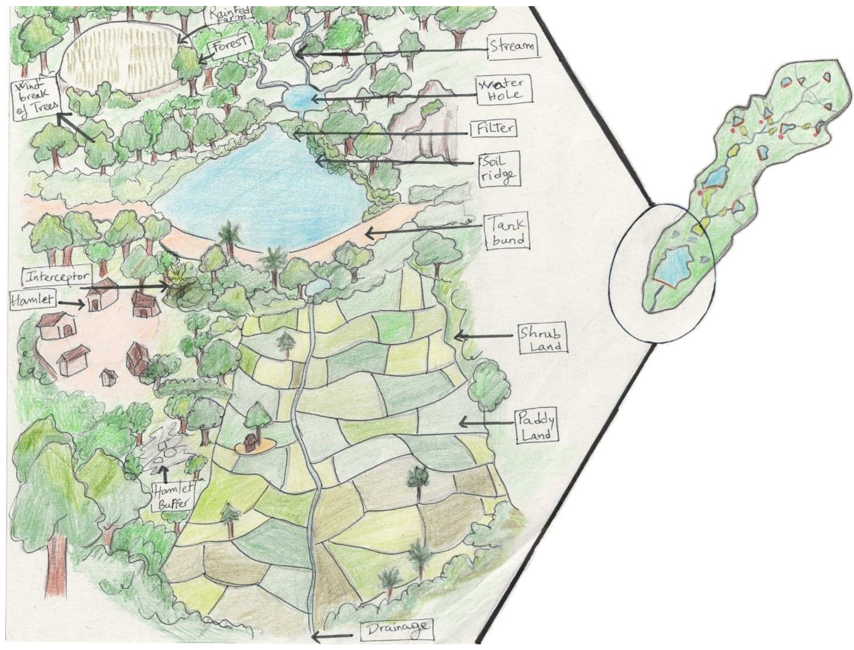
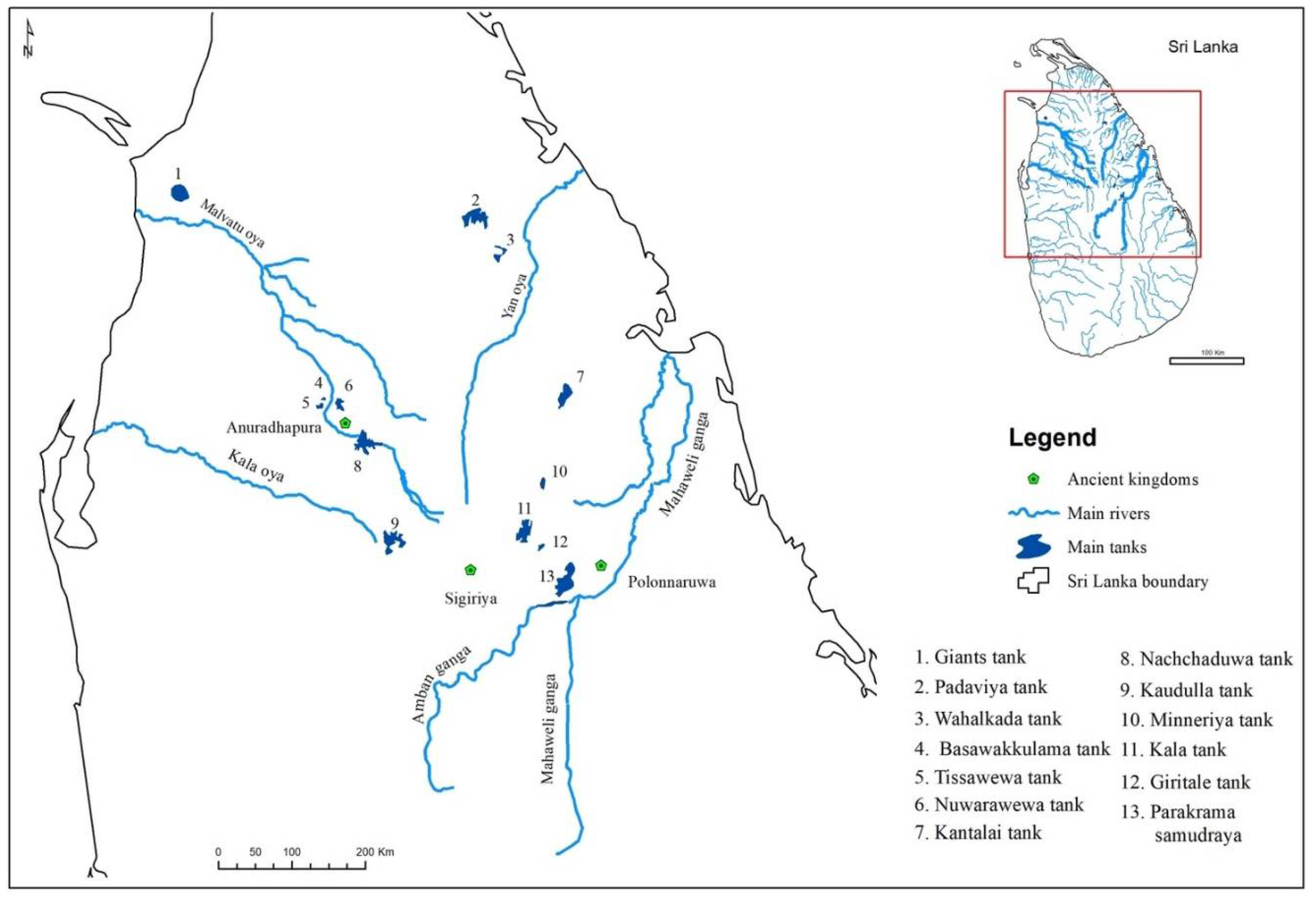
2. Development of the Tank Cascade System in the Dry Zone of Sri Lanka
3. Flood and Water Management Techniques in Ancient Kingdoms in Sri Lanka
4. Water Governance in Ancient Sri Lanka
5. Abandonment of Dry Zone Water Governance to Contemporary Water Governance
6. Conclusions
Author Contributions
Funding
Institutional Review Board Statement
Informed Consent Statement
Data Availability Statement
Conflicts of Interest
References
- Behailu, B.M.; Pietilä, P.E.; Katko, T.S. Indigenous Practices of Water Management for Sustainable Services: Case of Borana and Konso, Ethiopia. Special Issue-Traditional Wisdom. SAGE Open 2016, 6, 2158244016682292. [Google Scholar] [CrossRef] [Green Version]
- Geekiyanage, N.; Pushpakumara, D.K.N.G. Ecology of ancient Tank Cascade Systems in island Sri Lanka. J. Mar. Isl. Cult. 2013, 2, 93–101. [Google Scholar] [CrossRef] [Green Version]
- Abeywardana, N.; Bebermeier, W.; Schütt, B. Ancient Water Management and Governance in the Dry Zone of Sri Lanka Until Abandonment, and the Influence of Colonial Politics during Reclamation. Water 2018, 10, 1746. [Google Scholar] [CrossRef] [Green Version]
- Irrigation Department of Sri Lanka. Hydraulic Civilization and Water Resources in Sri Lanka. In Proceedings of the Hydro ASIA Fifth International Conference on Water Resources and Hydro Power Development in Asia, Colombo, Sri Lanka, 11–13 March 2014. [Google Scholar]
- Brohier, R.L. Ancient Irrigation Works in Ceylon. Part II. Northern and North-Western Sections of the Island; Superintendent of Surveys; Ceylon Government Press: Colombo, Sri Lanka, 1935. [Google Scholar]
- Dharmasena, P.B. Indigenous Water Resources Management in Sri Lanka. In Proceedings of the Conference on Environment and Humanity, Colombo, Sri Lanka, 19–20 August 2012. [Google Scholar]
- Dharmasena, P.B. Indigenous Irrigation Practices. National Science Foundation, Sri Lanka. Vidurava 2004, 32, 3–7. [Google Scholar]
- Turpin, T. Traditional Water Management in Sri Lanka & Its Relevance to the UK for Climate Change; Winston Churchill Memorial Trust: Colombo, Sri Lanka, 2006. [Google Scholar]
- Jayasena, H.A.H.; Chandrajith, R.; Gangadhara, K.R. Water Management in Ancient Tank Cascade Systems in Sri Lanka: Evidence for Systematic Tank Distribution. J. Geol. Soc. Sri Lanka 2011, 14, 29–34. [Google Scholar]
- Gangadhara, K.R.; Jayasena, H.A.H. Rainwater Harvest by Tank Cascades in Sri Lanka Was It a Technically Adapted Methodology by the Ancients? Department of Geology, University of Peradeniya: Peradeniya, Sri Lanka, 2014. [Google Scholar]
- Piyadigama, T.M. Indigenous Water Resource Management in Sri Lanka. 2017. Available online: https://www.researchgate.net/publication/330957196_Indigenous_Water_Resource_Management_in_Sri_Lanka (accessed on 14 December 2019).
- Dharmasena, P.B. Sustainability of Small Tank Irrigation Systems in Sri Lanka at the 21st Century. In Traversing No Man’s Land; Godage International Publishers (Pvt) Ltd.: Matara, Sri Lanka, 2009; pp. 233–252. [Google Scholar]
- Marambe, B.; Pushpakumara, G.; Silva, P. Biodiversity and Agrobiodiversity in Sri Lanka: Village Tank Systems. In The Biodiversity Observation Network in the Asia-Pacific Region: Toward Further Development of Monitoring. Ecological Research Monographs; Nakano, S., Yahara, T., Nakashizuka, T., Eds.; Springer: Tokyo, Japan, 2012. [Google Scholar] [CrossRef]
- Panabokke, C.R. The Small Tank Cascade System of the Rajarata; Mahaweli Authority of Sri Lanka: Colombo, Sri Lanka, 2000. [Google Scholar]
- Perera, M.P.; Chandima, D. Ancient Watershed Management Strategies in the Dry Zone of Sri Lanka. In Proceedings of the 3rd International Conference on Water & Flood Management (ICWFM), Dhaka, Bangladesh, 8–11 January 2011. [Google Scholar]
- Dharmasena, P.B. Water Resources Management for Agriculture in the Dry Zone of Sri Lanka. A Review of the Journal of Tropical Agriculture. 2012. Available online: https://www.academia.edu/14024262/Water_Resources_Management_for_Agriculture_in_the_Dry_Zone_of_Sri_Lanka_A_Review_of_the_Journal_of_Tropical_Agriculture (accessed on 20 December 2020).
- Gunasena, C. Structural and Non-Structural Water Management Concepts and Community Participation in Managing Land and Water Resources in Ancient Sri Lanka. Acedemia. 2018. Available online: https://www.academia.edu/36990554/Structural_and_nonstructural_water_management_concepts_and_community_participation_in_managing_land_and_water_resources_in_ancient_Sri_Lanka (accessed on 20 December 2020).
- Abeysinghe, A. Historical Evidence of Water Management in Ancient Sri Lanka. Econ. Rev. 1980, 6, 6–7. [Google Scholar]
- Wijesekera, S. Importance of Cascade Systems (Ancient Irrigation Systems) in Sustainable Development of Rural Communities in the Dry Zone of Sri Lanka (a Review of the Previous Studies). University of Kelaniya, Sri Lanka. 2015. Available online: http://repository.kln.ac.lk/handle/123456789/17710 (accessed on 14 December 2019).
- FAO. A Proposal for Declaration as a GIAHS. The Cascaded Tank-Village System (CTVS) in the Dry Zone of Sri Lanka; Ministry of Agriculture, Food and Agriculture Organization of the United Nations: Colombo, Sri Lanka, 2017. [Google Scholar]
- Gunnell, Y.; Krishnamurthy, A. Past and Present Status of Runoff Harvesting Systems in Dryland Peninsular India: A Critical Review. Ambio 2003, 32, 320–324. [Google Scholar] [CrossRef]
- Bebermeier, W.; Meister, J.; Withanachchi, C.R.; Middelhaufe, I.; Schütt, B. Tank Cascade Systems as a Sustainable Measure of Watershed Management in South Asia. Water 2017, 9, 231. [Google Scholar] [CrossRef] [Green Version]
- Dharmasena, P.B. Evolution of Hydraulic Societies in the Ancient Anuradhapura Kingdom of Sri Lanka. In Landscapes and Societies; Martini, I.P., Chesworth, W., Eds.; Springer: Dordrecht, The Netherlands, 2010; pp. 341–352. [Google Scholar] [CrossRef]
- Schütt, B.; Bebermeier, W.; Meister, J.; Withanachchi, C.R. Characterisation of the Rota Wewa tank cascade system in the vicinity of Anuradhapura, Sri Lanka. Die Erde J. Geogr. Soc. Berl. 2013, 144, 51–68. [Google Scholar]
- IUCN. Ecological Restoration of Kapiriggama Cascade Tank System. 2016. Available online: https://www.youtube.com/watch?v=DapXzbHLykQ (accessed on 14 December 2019).
- Pedro, P.d.S.; Tavares, A.O. 2015. Basin Flood Risk Management: A Territorial Data-Driven Approach to Support Decision-Making. Water 2015, 7, 480–502. [Google Scholar] [CrossRef] [Green Version]
- IUCN. Restoring Traditional Cascading Tank Systems for Enhanced Rural Livelihoods and Environmental Services in Sri Lanka; Cascade Development Project Information Brief No. 1; IUCN: Colombo, Sri Lanka, 2015. [Google Scholar]
- Hughes, J.; Cowper-Heays, K.; Olesson, E.; Bell, R.; Stroombergen, A. Impacts and implications of climate change on wastewater systems: A New Zealand perspective. Clim. Risk Manag. 2021, 31, 100262. [Google Scholar] [CrossRef]
- Uphoff, N. Learning from Gal Oya: Possibilities for Participatory Development and Post-Newtonian Social Science; Intermediate Technology Publications Ltd.: Rugby, UK, 1996. [Google Scholar]
- IPCC. Climate Change 2014: Impacts, Adaptation, and Vulnerability. Part A: Global and Sectoral Aspects; Working Group II Contribution to the Fifth Assessment Report of the Intergovernmental Panel on Climate Change (IPCC); Cambridge University Press: Cambridge, UK, 2014. [Google Scholar]
- Panabokke, C.R.; Sakthivadivel, R.; Weerasinghe, A.D. Evolution, Present Status and Issues Concerning Small Tank Systems in Sri Lanka; International Water Management Institute: Colombo, Sri Lanka, 2002. [Google Scholar]
- Kulatilake, S. The Peopling of Sri Lanka from Prehistoric to Historic Times: Biological and Archaeological Evidence. In A Companion to South Asia in the Past; Schug, G.R., Walimbe, S.R., Eds.; John Wiley & Sons, Inc.: Hoboken, NJ, USA, 2016; pp. 426–436. [Google Scholar]
- Premathilake, R. Relationship of environmental Changes in central Sri Lanka to possible prehistoric land-use and climate change. Palaeogeogr. Palaeoclimatol. Palaeoecol. 2006, 240, 468–496. [Google Scholar] [CrossRef]
- Piyadasa, R.U.K.; Weerasinghe, M.; Weerakoon, L.; Somadewa, R.; Vipulasena, M.P. Sustainable Ancient Water Management and Resilience to Climate Change in Sri Lanka. In Proceedings of the International Conference on Climate Change Impacts and Adaptation for Food and Environment Security, Los Baños, Philippines, 21–22 November 2012. [Google Scholar]
- Dharmasena, P.B. Water Balance of a Tank Cascade System in The Dry Zone. In 54th Annual Session of SLAAS; Part 1:123; Sri Lanka Association for the Advancement of Science: Colombo, Sri Lanka, 1998. [Google Scholar]
- Madduma Bandara, C.M. Tank cascade systems in Sri Lanka: Some thoughts on their development implications. In Summaries of Papers Presented at Irrigation Research Management Unit Seminar Series during 1994; Haq, K.A., Wijayaratne, C.M., Samarasekera, B.M.S., Eds.; IIMI: Colombo, Sri Lanka, 1995. [Google Scholar]
- Dharmasena, P.B. Guidelines for Tank Cascade Development; Concept Note Submitted to Plan Sri Lanka for Tank Cascade Development Programme; Department of Agriculture, Field Crops Research and Development Institute: Maha Iluppallama, Sri Lanka, 2005. [Google Scholar]
- Solangaarachchi, R. History of Metalaugury and Ancient Iron Smelting. Postgraduate Institute of Archology. University of Kelaniya. Vidurawa 1997, 19, 30–40. [Google Scholar]
- Mahatantila, K.; Chandrajith, R.; Jayasena, H.A.H.; Ranawana, K.B. Spatial and temporal changes of hydro geochemistry in ancient tank cascade systems in Sri Lanka: Evidence for a constructed wetland. Water Environ. 2008, 22, 17–24. [Google Scholar] [CrossRef]
- Dharmasena, P.B. Water use in Ancient Era. Vidurava 2001, 29, 3–9. [Google Scholar]
- Peiris, K.; Wijesinghe, S. Introduction to the Function of Bisokotuwa in Ancient Vewa. Engineer 2008, 41, 24–28. [Google Scholar] [CrossRef] [Green Version]
- Udalamatta, S.S. The Use of Water and Hydraulics in the Landscape Design of Sigiriya. Master’s Thesis, Department of Architecture, University of Moratuwa, Moratuwa, Sri Lanka, 2003. [Google Scholar]
- Bopearachchi, O. The Pleasure Gardens of Sigiriya-A New Approach; Godage International Publishers: Colombo, Sri Lanka, 2006. [Google Scholar]
- Mandawala, P.B. Buffer Zones in World Cultural Heritage Sites Sri Lankan Examples in Urban and Natural Setting; President ICOMOS Sri Lanka; International Council on Monuments and Sites: Colombo, Sri Lanka, 2006. [Google Scholar]
- Dumas, D.K. Sigiriya: An Early Designed Landscape in Sri Lanka. Orientations 2018, 49, 112–121. [Google Scholar]
- Karunachandra, T.D. Kuttam Pokuna (Twin Ponds). Acedemia. University of Moratuwa. Sri Lanka. 2018. Available online: https://www.academia.edu/42989540/KUTTAM_POKUNA_twin_ponds_?email_work_card=view-paper (accessed on 5 April 2022).
- Allceylon. Kuttam Pokuna (Twin Ponds). All Ceylon Tourism and Directory. Updated 20 October 2017. Available online: https://www.allceylon.lk/place/95-Kuttam-Pokuna-Twin-Ponds (accessed on 12 December 2019).
- Han, J.; He, S. Urban flooding events pose risks of virus spread during the novel coronavirus (COVID-19) pandemic. Sci. Total Environ. 2021, 755, 142491. [Google Scholar] [CrossRef]
- EPA. Flood Resilience: A Basic Guide for Water and Wastewater Utilities; EPA 817-B-14-006; Environmental Protection Agency: Washington, DC, USA, 2014. [Google Scholar]
- Siriweera, W.I. Sanitation and Health Care in Ancient Sri Lanka. Sri Lanka J. Humanit. 2004, XXIX & XXX, 1–12. [Google Scholar]
- Jayasundera, M. Ancient Sri Lankan Economic Systems. Financ. Mark. Inst. Risks 2017, 1, 24–27. [Google Scholar] [CrossRef] [Green Version]
- Abeywardana, N.; Pitawala, H.M.T.G.A.; Schütt, B.; Bebermeier, W. Evolution of the dry zone water harvesting and management systems in Sri Lanka during the Anuradhapura Kingdom; a study based on ancient chronicles and lithic inscriptions. Water Hist. 2019, 11, 75–103. [Google Scholar] [CrossRef] [Green Version]
- Dharmasena, P.B. Essential Components of Traditional Village Tank Systems. In Proceedings of the Seminar on Cascade Irrigation Systems for Rural Sustainability, Colombo, Sri Lanka, 9 December 2010. [Google Scholar]
- Mills, A.L. Ceylon Under British Rule 1795-1932: With an Account of the East India Company’s Embassies to Kandy 1762–1795; Frank Cass and Co. Ltd.: London, UK, 1933. [Google Scholar]
- Government of Sri Lanka. Flood Protection Ordinance. Flood Protection Ordinance No 4 of 1924; Government of Sri Lanka: Colombo, Sri Lanka, 1924. [Google Scholar]
- Mohamed, Z. Development of Integrated Water Resources Management Plan for Eastern Dry Zone in Sri Lanka: The Case of Gal Oya River Basin. 2019. Available online: https://www.pwri.go.jp/icharm/training/master/img/2019/synopses/08_Zuhail_synopsis.pdf (accessed on 14 December 2019).
- Chandrathilaka, W.A. Water Resources Management in Mahaweli and Adjoining River Basins in Sri Lanka. Engineer in Charge. Kotmale Dam and Reservoir. Mahaweli Authority of Sri Lanka. 2013. Available online: http://k-learn.adb.org/system/files/materials/2013/12/201312-water-resources-management-mahaweli-and-adjoining-river-basins-sri-lanka.pdf (accessed on 20 December 2020).
- Rathnayake, U.; Weerakoon, S.B.; Nandalal, K.D.W.; Rathnayake, U. Flood Modeling in the Mahaweli River Reach from Kotmale to Polgolla. In Proceedings of the International Conference on Mitigation of the Risk of Natural Hazards, Colombo, Sri Lanka, 25–26 March 2007. [Google Scholar]
- Weeraratne, S.; Wimalawansa, S.J. A Major Irrigation Project (Accelerated Mahaweli Programme) and the Chronic Kidney Disease of Multifactorial Origin in Sri Lanka. Int. J. Environ. Agric. Res. 2015, 1, 16–27. [Google Scholar]
- Somasiri, H.P.S. Participatory Management in Irrigation Development and Environmental Management in Sri Lanka. J. Dev. Sustain. Agric. 2008, 3, 55–62. [Google Scholar]
- Wijayaratne, C.M. Shared Control of Natural Resources (SCOR): An Integrated Watershed Management Approach to Optimize Production and Protection. Sri Lankan J. Agric. Econ. 1994, 4, 60–97. [Google Scholar]
- Wijayaratne, C.M.; Jayawardena, K. Shared Control of Natural Resources (SCOR): A Market Oriented Watershed Management Strategy. Executive Summary. Paper 73 of Session 10. CGSpace. 1998. A Repository of Agricultural Research Outputs. Available online: https://cgspace.cgiar.org/handle/10568/37999 (accessed on 19 December 2021).
- Elkaduwa, W.K.B.; Sakthivadivel, R. Use of Historical Data as a Decision Support Tool in Watershed Management: A Case Study of the Upper Nilwala Basin in Sri Lanka; Research Report 26; International Water Management Institute: Colombo, Sri Lanka, 1998. [Google Scholar]


Publisher’s Note: MDPI stays neutral with regard to jurisdictional claims in published maps and institutional affiliations. |
© 2022 by the authors. Licensee MDPI, Basel, Switzerland. This article is an open access article distributed under the terms and conditions of the Creative Commons Attribution (CC BY) license (https://creativecommons.org/licenses/by/4.0/).
Share and Cite
Hewawasam, V.; Matsui, K. Traditional Water Governance Practices for Flood Mitigation in Ancient Sri Lanka. Climate 2022, 10, 69. https://doi.org/10.3390/cli10050069
Hewawasam V, Matsui K. Traditional Water Governance Practices for Flood Mitigation in Ancient Sri Lanka. Climate. 2022; 10(5):69. https://doi.org/10.3390/cli10050069
Chicago/Turabian StyleHewawasam, Vindya, and Kenichi Matsui. 2022. "Traditional Water Governance Practices for Flood Mitigation in Ancient Sri Lanka" Climate 10, no. 5: 69. https://doi.org/10.3390/cli10050069
APA StyleHewawasam, V., & Matsui, K. (2022). Traditional Water Governance Practices for Flood Mitigation in Ancient Sri Lanka. Climate, 10(5), 69. https://doi.org/10.3390/cli10050069