Article

Operational Fire Management System (OFMS): A Sensor-Integrated Framework for Enhanced Fireground Situational Awareness

Faculty of Science and Technology, University of Canberra, Canberra 2617, Australia
*
Author to whom correspondence should be addressed.
J. Sens. Actuator Netw. 2025, 14(6), 114; https://doi.org/10.3390/jsan14060114
Submission received: 21 October 2025 / Revised: 21 November 2025 / Accepted: 24 November 2025 / Published: 26 November 2025

Abstract

This paper presents the design, development, and field testing of an Operational Fire Management System (OFMS) aimed at enhancing situational awareness and improving the safety and efficiency of firefighting operations. The system integrates real-time intelligence and remote monitoring to provide emergency management personnel and first responders with accurate information on vehicle location, communication status, and water level monitoring. Developed in collaboration with the Australian Capital Territory Rural Fire Service (ACT RFS), the OFMS prototype encompasses three core subsystems: the Monitoring and Environmental Sensing Subsystem (MESS), the Communication and Vital Monitoring Subsystem (CVMS), and the Command-and-Control Interface Subsystem (CCIS). MESS introduces a tilt-compensated ultrasonic algorithm for accurate water level estimation in moving fire trucks, CVMS leverages an open-source smartwatch with LoRa communication for real-time physiological tracking, and CCIS offers a cloud-based interface for live visualisation and coordination. Together, these subsystems form a practical and scalable framework for supporting frontline operations, particularly in rural firefighting contexts where vehicles are required to operate off-road and deliver large volumes of water to isolated locations. By providing real-time visibility of resource availability and crew status, the system strengthens operational coordination and decision-making in environments where connectivity is often limited. This paper discusses the design and implementation of the prototype, highlights key performance results, and outlines opportunities for future development, including improved environmental resilience, expanded sensor integration, and multi-agency interoperability. The findings confirm that the OFMS represents a novel and field-ready approach to fireground management, empowering firefighting teams to respond more effectively to emergencies and better protect lives, property, and the environment.

1. Introduction

The increasing frequency and severity of wildfires pose significant challenges for emergency response teams worldwide. For instance, the bushfires in Australia in 2019 and 2020 had a catastrophic impact, resulting in the loss of more than 30 human lives and over 3 billion animals, along with the destruction of thousands of homes and vast areas of land [1]. As these wildfires continue to pose significant threats to lives, properties, and ecosystems, there is an urgent need for comprehensive strategies and cutting-edge technologies to bolster firefighting efforts and protect vulnerable communities from the devastating impact of these natural disasters. One of these efforts is in the effective and rapid distribution of information and optimal resource allocation, which are crucial in mitigating the destructive impacts of such incidents. To address these challenges, the Operational Fire Management System (OFMS) is proposed with the aim of designing and implementing a real-time intelligent system for enhanced situational awareness during firefighting operations.
One prevalent challenge within fire management is the need for enhanced real-time monitoring of water levels. The effective utilisation of water resources is crucial in firefighting efforts, and existing systems often face limitations in providing immediate and accurate data on water levels. For instance, well-established technology, such as float gauges, has been used to provide visual indicators on the exterior of fire trucks; however, they may be susceptible to inaccuracies due to issues like tank tilting or debris interference [2]. Recent advancements involve the integration of digital sensors, offering a real-time electronic data transmission to a centralised control panel; however, the lack of portability of the control panel is another limitation. In this context, the fixed nature of centralised control panels may restrict their accessibility during certain firefighting scenarios, hindering firefighters from having immediate control and monitoring capabilities in diverse locations around the emergency site. Another type of method for water level measurement is the use of pressure transducers placed within the water tank to measure pressure changes; however, a common limitation of these is related to calibration drift and sensitivity to environmental conditions [3]. Knowing water levels in fire trucks is crucial for effective firefighting operations as it allows firefighters to maintain situational awareness, make informed decisions during emergency situations, and prevent disruptions due to unexpected water shortages. Thus, timely information on water availability is essential for strategic planning, resource allocation, and the overall efficiency of firefighting operations.
Another key aspect of fire management systems is the need to monitor firefighters and establish effective communication channels during fire scenarios. Firefighters operate in dynamic and hazardous environments where real-time information is crucial for ensuring their safety, coordination, and efficiency of firefighting operations [4]. Monitoring their vital signs’ location and overall well-being allows incident commanders to assess the physical condition of each firefighter, identify potential risks, and intervene promptly in case of emergencies [5,6]. Different sensing technologies can be used to monitor firefighters’ vital signs, such as body temperature, heart rate, blood pressure, electrodermal activity, or movement [7,8]. This information can be transmitted to a monitoring system, which allows firefighter commanders gain insights into the physical exertion experienced by firefighters during operations, providing an extra layer of safety by identifying early signs of heat stress or other physiological challenges [9]. Furthermore, establishing robust communication systems is essential for coordinating actions, relaying critical information, and adapting strategies as situations evolve [10]. Various technologies can be employed to facilitate information exchange between firefighters and fire commanders, including Long Range (LoRa), mesh networking protocols (e.g., Zigbee), or Bluetooth for short-range communication [11]. Clear and reliable communication enhances teamwork, ensures that firefighters are well-informed about changing conditions, and facilitates the execution of coordinated responses. Therefore, in challenging and rapidly changing fire scenarios, the ability to monitor and communicate effectively with firefighters not only enhances their safety but also plays a pivotal role in the overall success of firefighting efforts.
There is also an imperative need for sharing real-time information from the fire scenario for remote monitoring capabilities. Relevant information that can be shared includes critical data on water levels in fire trucks and physiological status of firefighters. The transmission of this information from the firefighting site to a centralised command centre is vital for comprehensive situational awareness and strategic decision-making. Different studies have provided examples of alert monitoring systems. For instance, Krishnamoorthy et al. [12] introduced a forest monitoring system to provide alerts and implement mitigation actions by utilising temperature, humidity, and smoke sensors; the objective of their system was to proactively prevent forest fire events, thereby ensuring safety of the forest environment. In another example, Prakash et al. [13] designed a flash flood monitoring system that collects meteorological and hydrological data of rivers, such as water flow, water level, water discharge, temperature, humidity, and wind speed; the system aimed to prevent and reduce the catastrophic damage caused by floods. Cicioglu and Calhan [14] developed a fire zone monitoring system that employs sensors on each firefighter to measure fireground coordinates, fire temperature, and toxic gas levels in the environment; the primary objective of this monitoring system is to promptly identify high-risk areas within disaster environments, facilitating faster and more accurate implementation of intervention strategies. Overall, the dynamic nature of fire incidents demands instant access to data on the fire’s progression, enabling commanders to organise efficient resource allocation and tactical adjustments.
In this context, the key problems that the OFMS aims to solve encompass several crucial aspects of firefighting operations. These key aspects include the lack of accurate vehicle water level monitoring, inefficient communication through radio channels, unawareness of firefighters regarding water levels when out of sight of their trucks, and the absence of a method to track water usage and sources. The system is also designed to enhance safety by monitoring the physiological parameters of firefighters during operations. Additionally, the system is devised to design and implement a real-time monitoring system for enhanced situational awareness during firefighting operations. The proposed system aims to address these challenges, leading to improved firefighting efficiency and safety, resulting in a more effective and responsive approach to handling emergencies. Existing solutions for water level monitoring and communication suffer from inaccuracies, time-consuming manual methods, lack of real-time updates, unnecessary radio traffic, and limited situational awareness for firefighters [10,15]. In addition, a significant problem with current systems, is that fireground commanders struggle with obtaining timely and precise water level data, hindering resource allocation and coordination. These limitations emphasise the need for an advanced system like the OFMS that provides real-time water level monitoring and efficient communication.
To address these operational gaps, and developed in close collaboration with the ACT RFS, the design of the OFMS is centred on three core objectives that directly target the identified limitations. Accordingly, the proposed system offers the following key contributions.
  • The system introduces a novel tilt-compensated sensing model that integrates ultrasonic ranging with IMU correction to achieve accurate, real-time water-level estimation in moving fire trucks using lightweight embedded processing.
  • It develops a dedicated long-range physiological monitoring and communication network based on LoRa technology, enabling reliable transmission of firefighter vital-sign data in low-connectivity or congested environments.
  • OFMS proposes a unified multimodal command-and-control architecture that fuses environmental, physiological, and operational data into a single decision-support interface, enhancing situational awareness, strategic planning, and real-time coordination during firefighting operations.
Overall, the proposed system not only enhances situational awareness but also helps prevent situations where firefighting efforts may be compromised due to insufficient water supply. By alerting the firefighting team about low water levels, it enables timely interventions and resource planning, ensuring the firefighting process remains well-coordinated and efficient.

2. Related Work

Efforts to improve fireground situational awareness increasingly draw on advances in multimodal sensing, long-range communication, edge intelligence, and privacy-preserving data processing. Existing studies span three primary domains: wearable physiological monitoring, environmental and vehicle-mounted sensing, and integrated IoT frameworks for emergency response, each addressing specific challenges relevant to firefighting operations.

2.1. Wearable Physiological Monitoring

Firefighters are routinely exposed to hazardous conditions where physiological overload and heat stress can escalate rapidly. Prior work has explored wearable biomedical devices to improve early detection of physiological risk. For instance, Coca et al. demonstrated the feasibility of continuous plethysmographic monitoring for cardiovascular strain in operating firefighters, highlighting the need for real-time vital-sign tracking under full protective gear [4]. Raj et al. further introduced an IoT-based stress-detection system using biomedical sensors for real-time classification of firefighter stress levels [8]. In addition, other previous wearable solutions such as PyroGuardian [16] or the integrated health-monitoring system of Lioliopoulos et al. [17] focused on limited metrics or proprietary devices. Although these systems demonstrate the value of physiological sensing, they often rely on proprietary hardware and lack extensible interfaces for integration with broader command-and-control systems. In contrast, the OFMS architecture leverages an open-source smartwatch combined with LoRa communication to provide a replicable and flexible vital-monitoring subsystem for operational use.

2.2. Environmental and Vehicle-Mounted Sensing

Accurate water-tank measurement remains a critical yet persistently under-addressed challenge in rural firefighting. Traditional float gauges suffer from inaccuracies due to tilt, debris, or reduced visibility in smoke-filled conditions [2]. Modern approaches include pressure transducers and ultrasonic systems, but these often assume static installations and cannot generalise to dynamic vehicle motion [3]. Research by Terzic et al. introduced SVM-based compensation for fluid-level estimation in moving vehicles [18], while Sahoo et al. employed adaptive neural networks for ultrasonic correction under varying angles [19]. However, these approaches require extensive training data and computational resources. The OFMS water-level subsystem instead integrates IMU-based tilt estimation with a computationally lightweight modal-binning algorithm, enabling real-time correction under realistic off-centre sensor placements and variable terrain conditions.
Several studies have leveraged IoT platforms to support environmental hazard detection across disaster scenarios. For instance, Krishnamoorthy et al. proposed a forest-alert system using temperature, humidity, and smoke sensors for early ignition detection [12], while Cicioğlu and Calhan developed a firefighter-centric platform to monitor toxic gases and spatial coordinates within disaster zones [14]. Prakash et al. developed FLOODWALL, a real-time flash-flood monitoring and forecasting system that integrates hydrological and meteorological sensors through an IoT backbone to enhance situational awareness during extreme weather events [13]. Likewise, Srinjoy Sengupta proposed an IoT-based urban disaster management framework that leverages heterogeneous sensing networks and cloud analytics to predict and visualise flood and fire risks in dense metropolitan environments [20]. While these systems demonstrate scalable architectures for environmental monitoring, they remain primarily hazard-specific and lack the multi-domain integration that combines environmental, physiological, and operational sensing. The proposed OFMS builds on these advances by fusing environmental and vehicle-mounted sensing with wearable physiological monitoring and cloud-based coordination to provide an end-to-end solution for emergency response operations.

2.3. Integrated IoT Frameworks for Emergency Response

Beyond application-specific systems, recent research has advanced semantic-driven, adaptive, and privacy-preserving IoT frameworks designed to enhance data intelligence and communication efficiency across distributed environments. Peng et al. introduced Simac, a semantic-driven multimodal sensing and communication framework that enables context-aware data fusion across heterogeneous devices [21], while Luo et al. proposed a reconfigurable intelligent sensing surface architecture that supports forward-only transmission and improved energy efficiency for large-scale IoT networks [22]. Complementary studies have focused on privacy-preserving IoT communication and data management, which are essential in multi-agency emergency contexts where sensitive operational and personal data are exchanged. For instance, Zhao et al. developed a Private and Effective Range Counting Query mechanism to ensure differential privacy in evolving IoT data streams [23] and Zhao et al. proposed a Road-Network-Aware Differentially Private Framework for secure handling of location and histogram queries [24]. Collectively, these studies reflect the growing shift toward secure, adaptive, and semantically enriched IoT ecosystems. However, despite these advances, such frameworks have not yet been translated into safety-critical, real-time emergency operations, where robustness, interoperability, and latency constraints remain decisive. The OFMS addresses this gap by operationalising these principles into a field-deployable, multimodal architecture that unifies sensing, communication, and decision intelligence for next-generation emergency response.
Table 1 summarises how prior studies across wearable monitoring, environmental and vehicle-mounted sensing, and integrated IoT frameworks have contributed to firefighting technology. It also highlights how the proposed Operational Fire Management System (OFMS) advances these efforts through subsystem integration, improved sensing accuracy, extensible physiological monitoring, and a unified situational-awareness interface.

3. Methodology

The proposed smart truck framework comprises three core subsystems: the Communication and Vital Monitoring Subsystem (CVMS), the Monitoring and Environmental Sensing Subsystem (MESS), and the Command-and-Control Interface Subsystem (CCIS). The CVMS focuses on long-range communication and real-time vital sign monitoring, while the MESS emphasises water level measurement, environmental sensing, and real-time location tracking. The CCIS provides a centralised command-and-control interface, integrating data from the other subsystems and external sources for enhanced situational awareness. Figure 1 illustrates the overall architecture of the proposed system. The following sections outline the design, implementation, and evaluation of each subsystem.

3.1. Communication and Vital Monitoring Subsystem (CVMS)

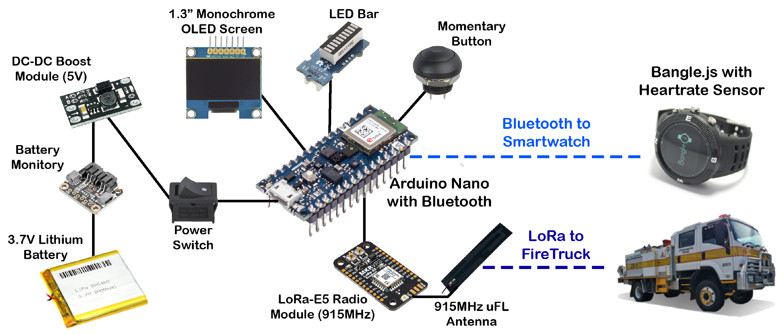
The CVMS is a pivotal component of the smart truck framework designed to improve firefighter safety by providing reliable long-range communication and real-time vital sign monitoring and displaying essential information such as water level during emergency operations. The CVMS combines a handheld wireless monitoring device and a Bluetooth Smartwatch to establish reliable communication and real-time monitoring of vital signs in challenging firefighting environments. These two components are described in the following subsections. The architecture of the CVMS is illustrated in Figure 2.

3.1.1. Handheld Wireless Monitoring Device

The handheld wireless monitoring device functions as the primary communication interface for firefighters. An Arduino Nano microcontroller serves as the central processing unit, managing the device’s components and operations. For data transmission, the device utilises the LoRa (Long Range) standard, chosen for its low-power and long-range capabilities. Its LoRa-E5 module operates in compliance with the Radiocommunications (Low Interference Potential Devices) Class Licence 2015, under the Radiocommunications Act 1992 [25]. The LoRa-E5 module provides reliable connectivity in remote terrains where traditional cellular networks may be limited or unavailable. A further selection criterion was the module’s low power consumption, which extends the handheld’s battery life for prolonged operation in off-grid settings, a critical requirement for remote deployments. The integrated hardware forms a functional unit capable of transmitting and receiving data over distances of several kilometres.
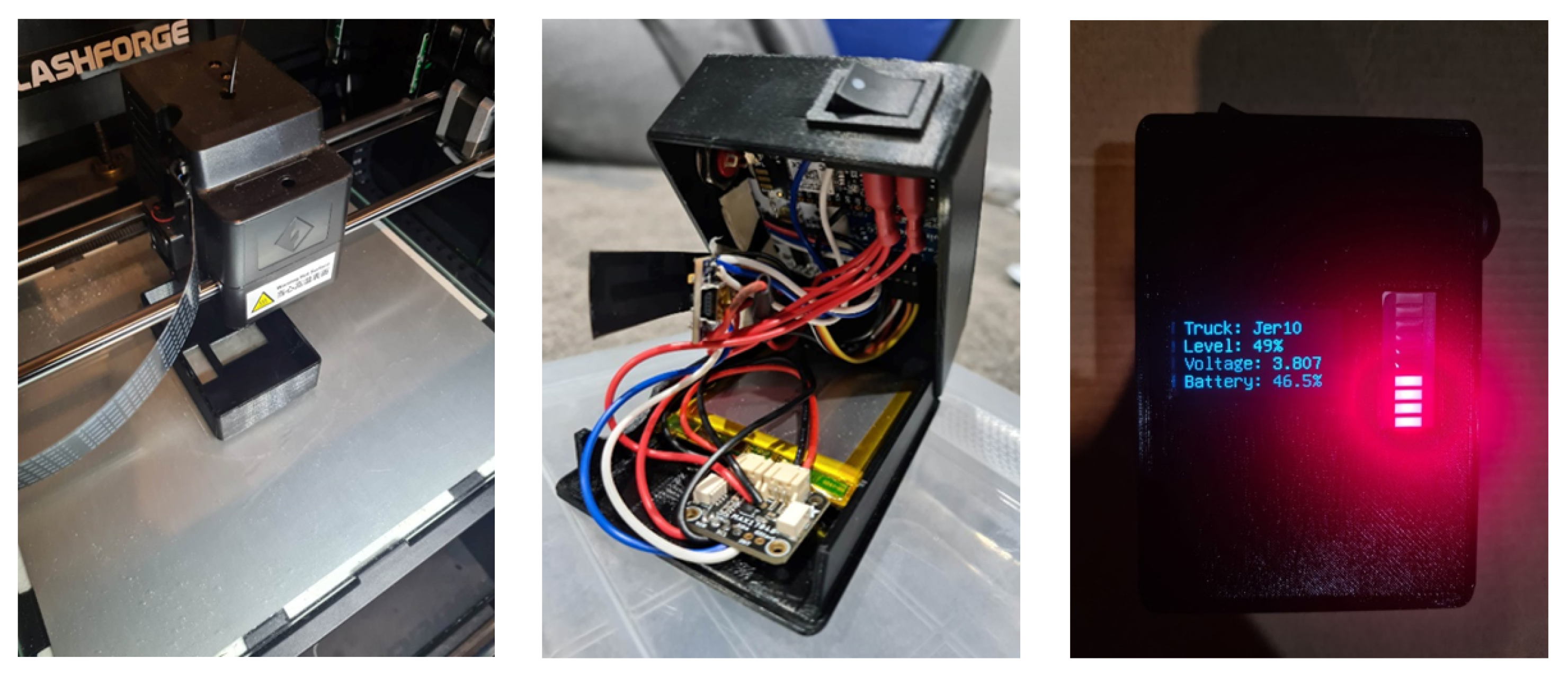
Beyond its communication capabilities, the handheld device functions as a data display unit for essential information relayed from the fire vehicle. The primary data displayed are the real-time water level readings, which allows for efficient water management during operations. The device is also designed to present warnings and data from other vehicle-mounted sensors, such as high wind speed or poor air quality alerts. This information is presented to the firefighter on a monochrome OLED screen and a multi-colour LED bar, providing immediate situational awareness to support tactical decision-making in dynamic environments. The housing for the electronic components was custom-designed and fabricated using a 3D printer with polylactic acid (PLA) bioplastic. The design underwent multiple iterations to optimise internal component spacing and the overall physical dimensions of the unit.

3.1.2. Bluetooth Smartwatch for Vital Monitoring

Physiological monitoring is accomplished using a Bangle.js, an open-source smartwatch (Espruino Ltd., Cambridge, UK) shown on the right of Figure 2. This device was selected for its customisable, open-source hardware and firmware, making it a fully replicable platform [26]. For this study, custom firmware was developed to use the integrated photoplethysmography (PPG) sensor for real-time heart rate monitoring of firefighters. While only the heart rate sensor was employed, the Bangle.js also includes an accelerometer, magnetometer, GPS, and temperature sensor, offering clear pathways for future expansion of monitoring capabilities. The smartwatch’s touch display and vibration motor are used for notifications and user interaction. The use of this commercially available, open-source technology provides a compact and economically viable solution for vital sign monitoring.

3.2. Monitoring and Environmental Sensing Subsystem (MESS)

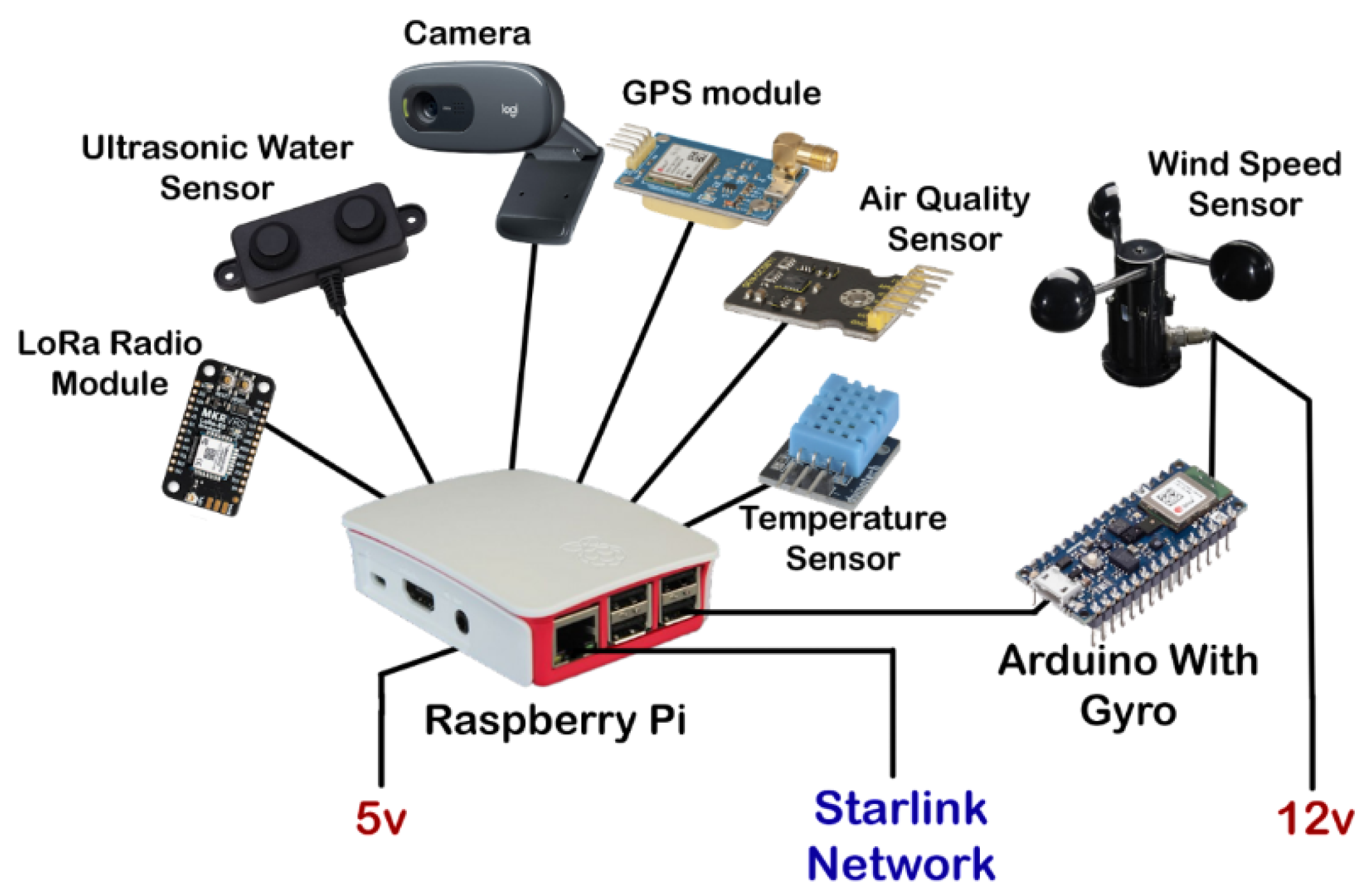
The MESS consists of several key subcomponents: a GPS for real-time tracking, an ultrasonic water level sensor paired with a gyroscope for water level monitoring, along with a camera, air quality sensor, temperature sensor, and wind speed sensor. Figure 3 provides an illustrative overview of these components.

3.2.1. Water Level Sensing

The MESS is primarily dedicated to water level measurement, a critical aspect for efficient firefighting coordination. An ultrasonic sensor (A02YYUW, DFRobot, Shanghai, China) was chosen for its ability to measure distance without physical contact and for its waterproof design. To compensate for the vehicle’s tilt when positioned on uneven terrain, a gyroscope and accelerometer (IMU–BMI270, Bosch Sensortec, Reutlingen, Germany) are integrated into anArduino Nano 33 BLE Sense Rev2 (Arduino, Monza, Italy). This allows the system to measure the tank’s roll and pitch angles and dynamically integrate that gyroscopic data with the distance readings from the ultrasonic sensor.
To calculate the water volume, the algorithm provides a conceptual simplification. Instead of measuring the water directly, it is simpler to measure the volume of the *empty space* above the water ( V empty ) and subtract this from the tank’s known maximum volume ( V max ).
This relationship is defined as
V = V max V empty
The maximum volume V max is the straightforward volume of the tank:
V max = H · L · W
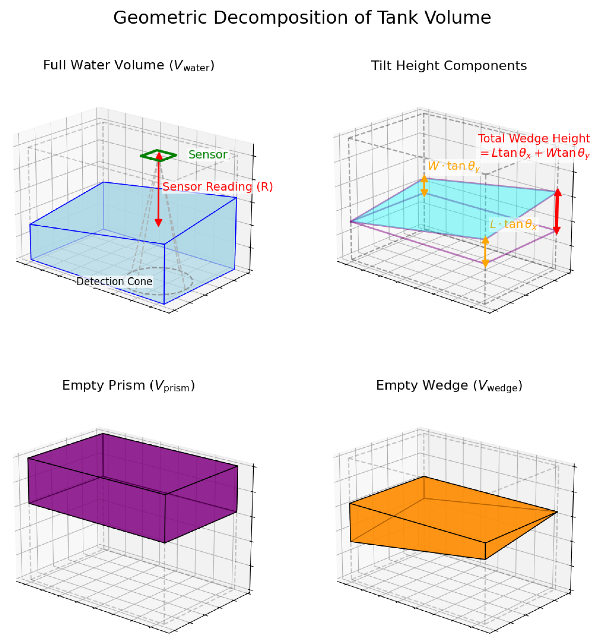
The primary challenge is calculating V empty when the tank is tilted. Our algorithm solves this by decomposing the empty space into two distinct geometric components that are simple to calculate: (1) a principal rectangular prism ( V prism ) representing the main empty volume and (2) a corrective wedge volume ( V wedge ) that accounts for the slanted water surface. The IMU provides the tilt angles used to define these shapes. Figure 4 presents the graphical representation oof the volume calculation method.
This decomposition is defined as
V empty = V prism + V wedge

Empty Prism Volume ( V prism )

The height of this prism ( V prism ) is determined by taking the raw sensor reading (R), accounting for the sensor’s vertical mounting offset (D), and correcting for its off-centre position ( x s , y s ) relative to the measured tilt angles ( θ x , θ y ). This calculation effectively finds the distance from the top of the tank to the water surface at a single reference corner ( 0 , 0 ) . The volume is defined as
V prism = ( R + D ) x s tan θ x y s tan θ y · L · W

Empty Wedge Volume ( V wedge )

This corrective wedge ( V wedge ) represents the empty, wedge-shaped volume that lies between the flat plane defined by the prism’s base and the tilted water surface itself. Its volume is derived from the tank dimensions and tilt angles as
V wedge = ( L tan θ x + W tan θ y ) · L · W 2
where
V    is the volume of the tank (cm3);
H    is the tank height (cm);
W   is the tank width (cm);
L     is the tank length (cm);
D    is the tank lid depth (cm);
R     is the ultrasonic sensor reading (cm);
xs, ys    are the sensor’s off-centre coordinates (cm), measured manually
    from the tank’s (0,0) reference corner to the sensor centre;
θxθy  are the measured tilt angles (degrees).
Sensor Calibration
The gyroscope, mounted directly to the lid of the test tank, required calibration to compensate for minor physical mounting misalignments. The procedure involved placing the tank on a verified level surface to establish a zero-point reference for both pitch and roll. This baseline was then used as an offset for all subsequent tilt measurements, ensuring their accuracy relative to true level. Any measurement variations from the ultrasonic sensor were addressed by the data processing algorithm outlined in the experimental procedure.
Experimental Validation
To validate the accuracy of the sensing system and the tilt-correction algorithm, a physical experiment was conducted under controlled conditions. An 18-litre rectangular prism tank, with geometric properties similar to the target vehicle’s tank, was used.
The experimental procedure was as follows:
  • A known volume of water (5.0 Litres) was precisely measured and placed into the tank.
  • The tank was manually tilted to numerous compound angles, with the total absolute tilt ranging from 0 to over 20 degrees.
  • For each static angle, a semi-automated data acquisition process was initiated using a custom Python (version 3.13.0) script. This process was repeated 10 times per angle to assess the system’s precision.
  • Each triggered measurement consisted of a rapid collection of 100 raw sensor samples. To ensure a robust reading free of outliers or noise, these samples were processed on the Arduino using a statistical “modal binning” algorithm. This method identifies the most frequent (modal) value by grouping the samples into 1 mm bins. It then calculates the average of only the readings belonging to that dominant group, yielding a single, stable data point for each measurement.

3.2.2. On-Vehicle Data Processing and Environmental Sensing

A Raspberry Pi 4 serves as the central processing hub for the MESS, handling real-time data aggregation and calculations, including the water level volume. Connected to the Raspberry Pi are several environmental sensors to provide a holistic view of the operational environment (Figure 3). These include a wind sensor (QS-FS01, DFRobot, Shanghai, China), a temperature and humidity sensor (DHT11, Aosong Electronics Co., Guangzhou, China), and an air quality sensor (CCS811, ScioSense, Eindhoven, The Netherlands). Additionally, a camera (C270, Logitechm Lausanne, Switzerland) was integrated on a servo mount, allowing it to be remotely rotated via controls in the web interface to provide a live video stream, enhancing real-time situational awareness.

3.2.3. Real-Time Tracking

Real-time vehicle location tracking is enabled through the NEO-7M GPS module (u-blox AG, Thalwil, Switzerland), which delivers high-accuracy positioning with a precision of up to 2.5 m. This capability ensures reliable and continuous location updates, providing critical spatial data to support coordination, navigation, and operational efficiency during firefighting efforts.

3.2.4. Data Transmission

The system’s back-end data transmission architecture was specifically designed to operate reliably in remote and rural environments where traditional connectivity is often limited. The initial implementation utilised an SIM module with Narrowband IoT (NB-IoT) connectivity over a 4G LTE network. This technology was selected for its low power consumption, wide coverage, with theoretical data rates up to 26 Kbps. However, our field testing revealed that network availability was inconsistent in remote rural contexts, and this bandwidth was insufficient for features like video streaming. To address these challenges and enable higher data throughput, the system was upgraded to leverage Starlink’s satellite-based communication infrastructure. This enhancement provides robust, low-latency, and high-speed data transmission (typically 50–150 Mbps download) with an average operational power draw of 50–75 Watts, ensuring continuous real-time monitoring and seamless data capture from virtually any location, including areas beyond the reach of terrestrial cellular networks.

3.3. Command-and-Control Interface Subsystem (CCIS)

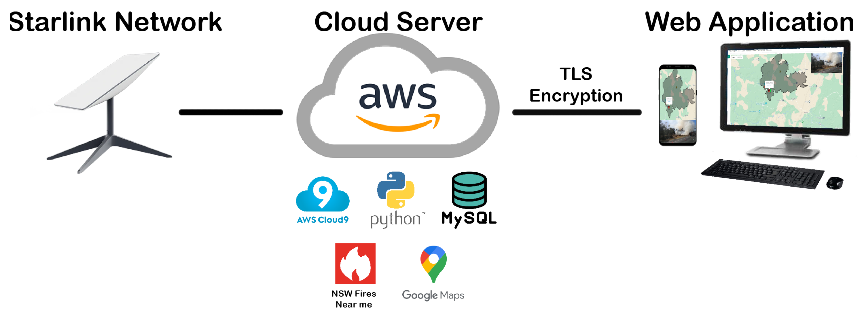
The Command-and-Control Interface Subsystem (CCIS) is a web-based platform that provides a comprehensive overview of the operational environment for firefighting personnel. It is composed of a front-end web application and a back-end cloud architecture that handles data reception, processing, and storage. The CCIS architecture is shown in Figure 5.

3.3.1. Web Application and Data Integration

The primary user interface for the CCIS is a web application designed to collect, process, and display data from the CVMS and MESS subsystems. The application integrates the Google Maps API to provide a real-time geospatial view of vehicle locations, water levels, and other sensor data. To further augment situational awareness the application also integrates external data feeds. It consumes the publicly available GeoJSON data feed from the NSW RFS, which serves as the data source for the official Fires Near Me application. As this is a public-facing data stream, no formal permission or API key is required for its use. The system is configured to periodically poll this HTTP endpoint for updates. The refresh interval is set to five minutes to align with the feed’s known update cycle and ensure responsible use of the public infrastructure.

3.3.2. Back-End Architecture and Data Processing

The CCIS back-end is hosted on an Amazon Web Services (AWS) virtual cloud server, which provides the necessary infrastructure for data storage and processing. A MySQL database was deployed on the server for structured and flexible data storage and retrieval. Security is maintained through Transport Layer Security (TLS) encryption and HTTP basic authentication, ensuring that only authorised users can access the system. For testing and demonstration purposes, the domain actfire.watch was registered and linked to the server’s public IP address.
Data generated by the vehicle’s MESS unit is transmitted to the CCIS back-end via the Starlink satellite network, ensuring connectivity even in remote locations. A dedicated Python script running on the server manages the incoming data stream, performing parsing, validation, and storage into the MySQL database. To support real-time access, a PHP-based API exposes secure endpoints that the front-end web application uses to retrieve and visualise location and status updates on the map interface.

4. Results

This section presents the performance and evaluation of the prototype system, focusing on the outcomes for each of the three core subsystems. The evaluation highlights the practical implications of the design, providing insights into how effectively the system meets its intended objectives and identifying areas for potential refinement.

4.1. CVMS Prototype and Sensor Integration

Field testing of the Communication and Vital Monitoring Subsystem (CVMS) prototype confirmed the viability of its core functions. A stable long-range communication link was established between the handheld device and the vehicle-mounted unit, enabling successful real-time transmission of water level and battery status data across distances of several kilometres. These results demonstrate the effectiveness of the LoRa-based communication standard in challenging rural environments, significantly outperforming traditional short-range technologies. The iterative development of the handheld device housing is shown in Figure 6. The enclosure was custom-designed using 3D modelling software (Tinkercad, version 1.4, Autodesk Inc., San Francisco, CA, USA) and manufactured with a 3D printer using polylactic acid (PLA) bioplastic. Several design iterations were undertaken to optimise the layout, addressing issues such as component spacing, durability, and overall device size. Together, these outcomes confirm the CVMS prototype’s suitability for real-world firefighting operations, where reliable communication and field-ready hardware are essential. Future improvements will focus on enhancing the enclosure with greater environmental resistance, such as water- and dust-proofing, as well as refining ergonomics and ensuring compliance with operational safety standards.
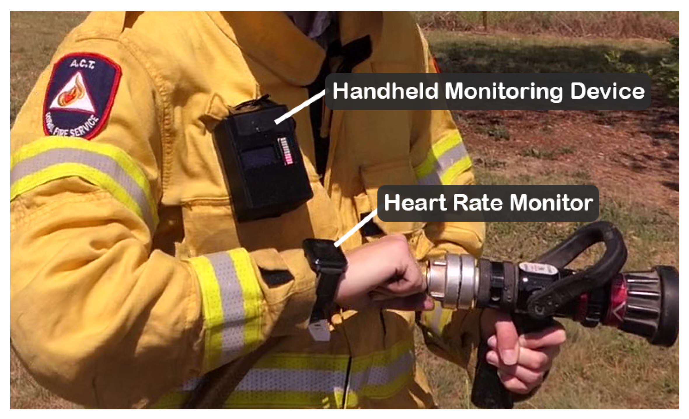
The integration of the Bangle.js smartwatch (Figure 7) demonstrated the feasibility of unobtrusive, real-time vital sign monitoring during field tests. The prototype, equipped with custom firmware, successfully collected and transmitted heart rate data from its PPG sensor to the handheld device. The raw PPG signal was successfully processed to identify individual heartbeats. Figure 8 illustrates a representative interval of the PPG waveform, corresponding to an average heart rate of 72.95 beats per minute (BPM). This confirmed the practicality of wearable-based physiological monitoring within the CVMS architecture. At present, the implementation is limited to basic heart rate monitoring and does not yet include localised alerts based on pre-defined physiological or environmental thresholds. Future iterations could expand functionality by leveraging the existing communication infrastructure to support additional data streams, such as SpO2, activity levels, or stress indicators, and deliver proactive alerts on high wind speeds or hazardous conditions. These enhancements would improve early warning capabilities, strengthen firefighter safety, and contribute to a more comprehensive vital monitoring system.

4.2. MESS Water Level Experimental Results

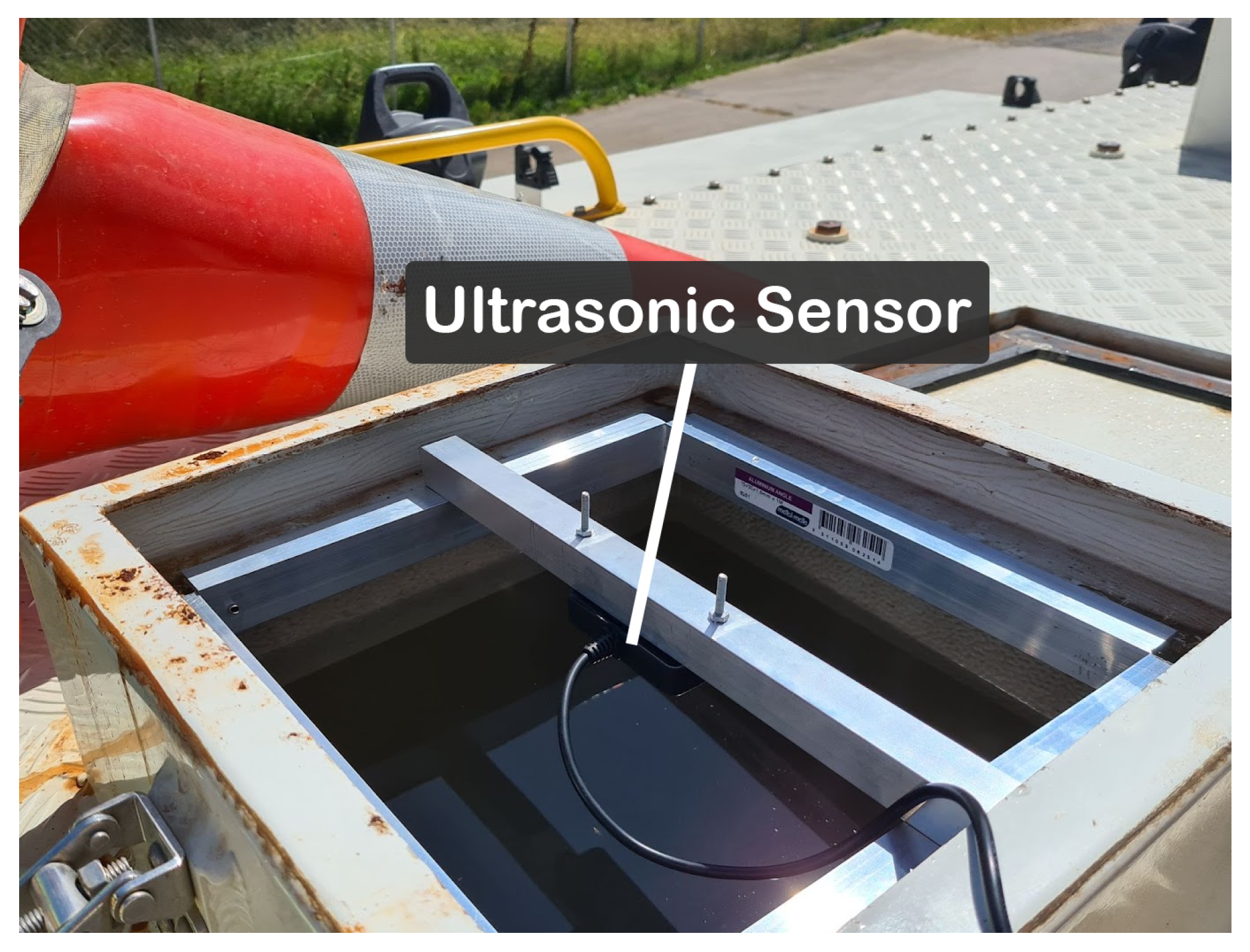
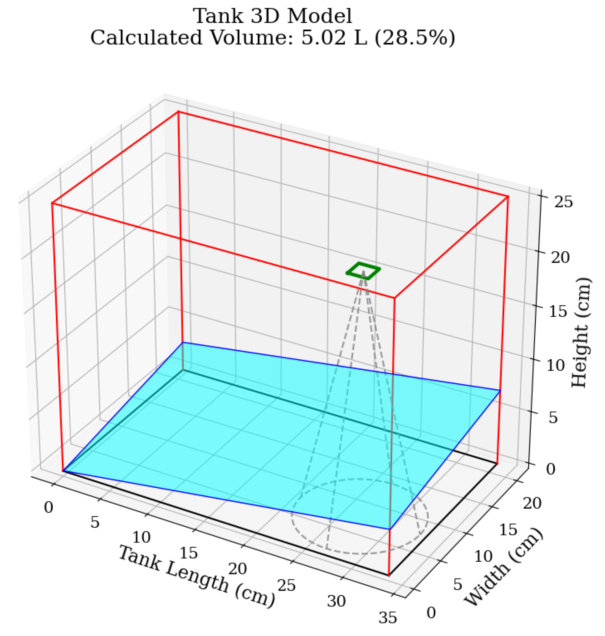
The physical experiment validated the accuracy of the MESS water level sensing system and the performance of its tilt-correction algorithm. The system is designed to be retrofitted onto existing fire trucks, which involves installing the sensor into available top-fill hatches using a custom bracket (Figure 9). On the target vehicles, these hatches are not located on the tank’s central axes but are positioned within a quadrant of the tank’s top surface, creating a significant offset. This placement amplifies measurement error when the vehicle tilts. The experiment was designed to model this specific off-centre scenario using a proportionally similar test tank (Figure 10).
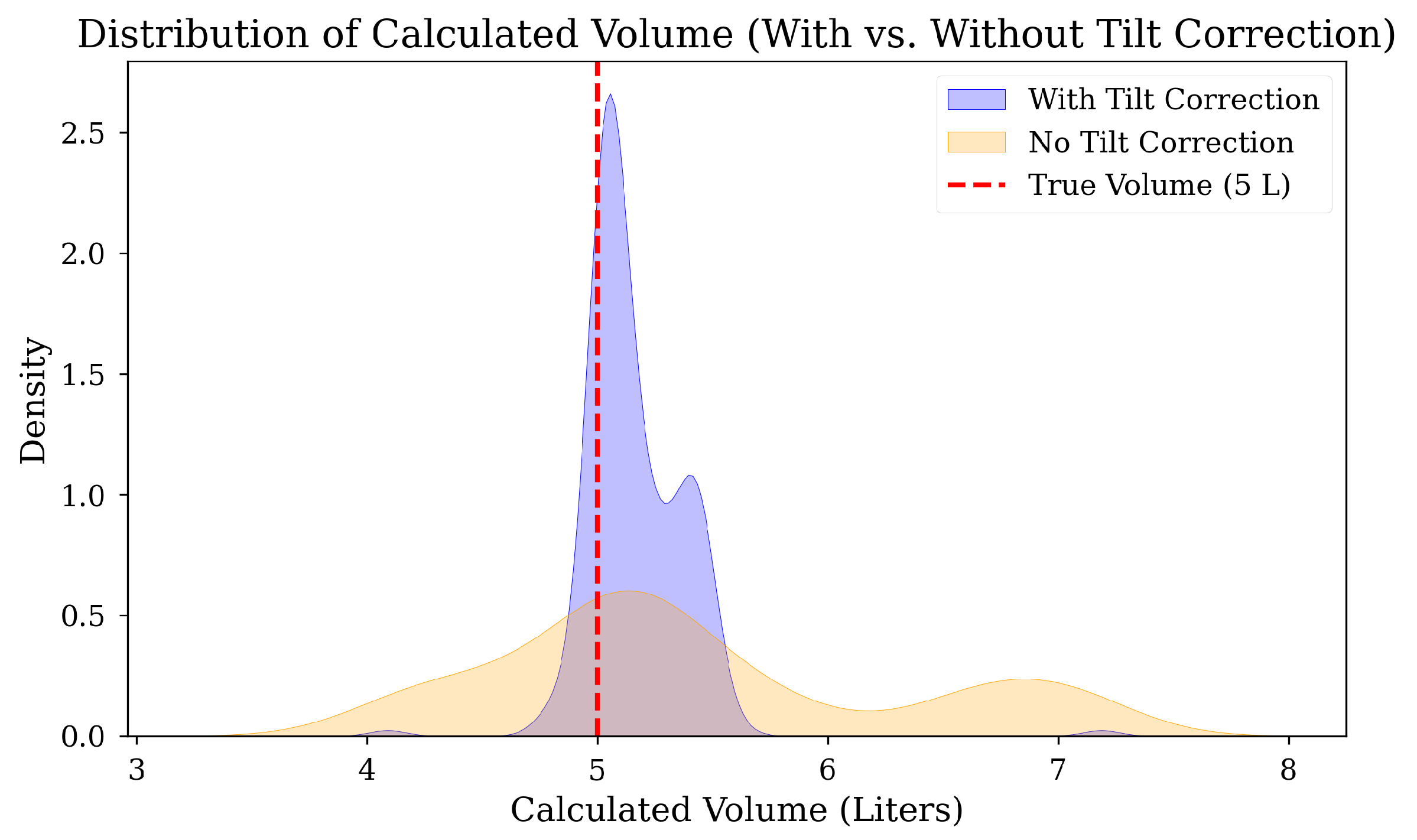
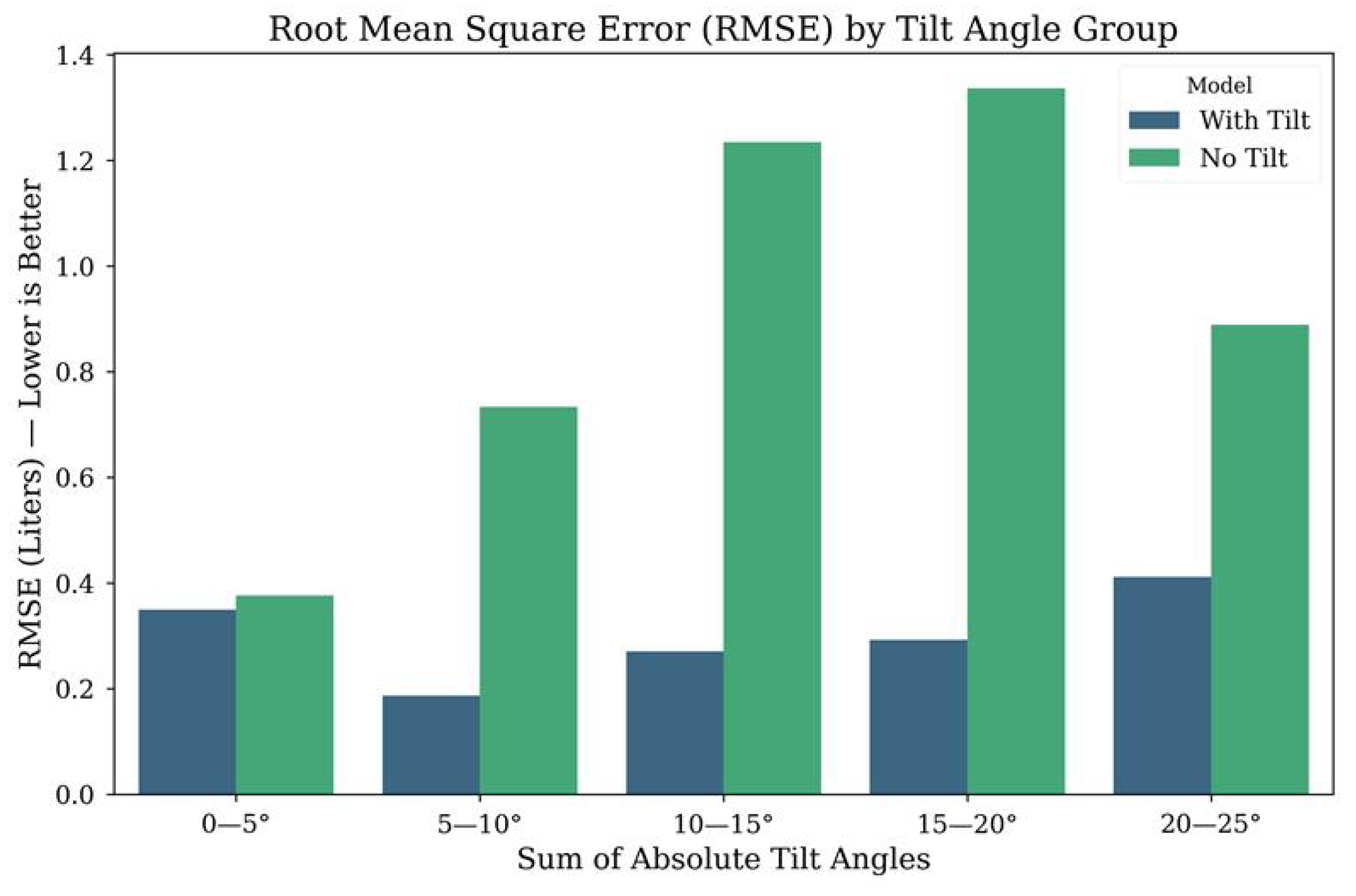
The experiment was conducted with a reference water volume of 5.0 litres to evaluate measurement accuracy. Results confirm that the tilt-correction algorithm is essential for reliable performance. As shown in Figure 11, the corrected data (blue) is tightly clustered around the true volume (dotted red line), whereas the uncorrected data (yellow) displays wide variance and reduced accuracy. This improvement was further quantified using Root Mean Square Error (RMSE) across different tilt angle groups (Figure 12). The analysis demonstrates that measurement error increases substantially with tilt in the uncorrected model, while the tilt-corrected model maintains consistently low RMSE across all angles, validating its effectiveness for field deployment.
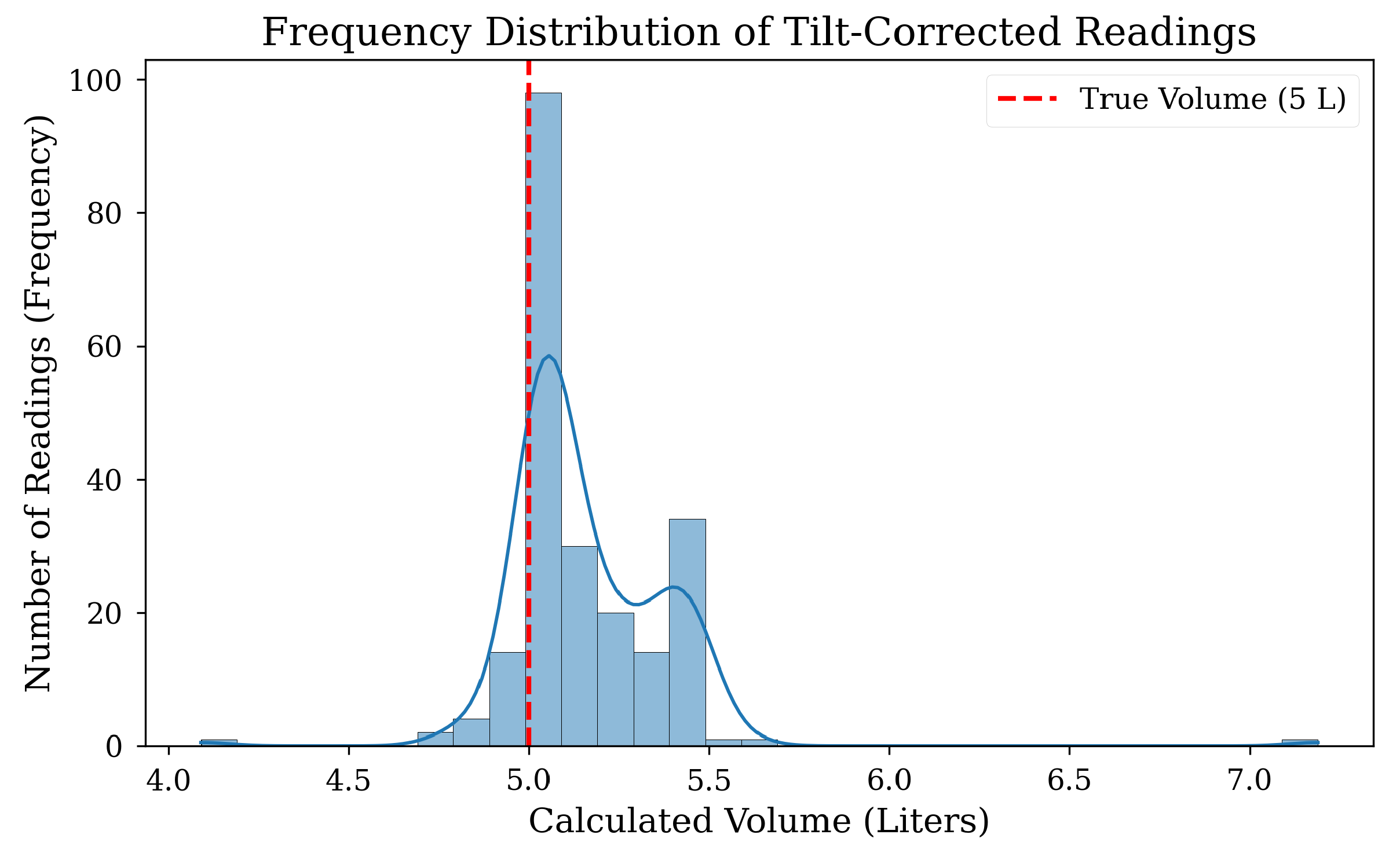
A frequency analysis of the corrected readings reveals a bimodal distribution (Figure 13). The dominant cluster is centred on the true 5.0 L volume, but a secondary peak of inaccurate readings is also present. At shallow tilt angles (0–5°), multi-path reflections occur intermittently, producing a small set of outliers that inflate the RMSE despite the majority of readings being accurate. As the tilt increases (5–10°), more of the ultrasonic beam energy is consistently directed towards the walls, making the reflections more predictable and easier for the on-device “modal binning” algorithm to suppress. This explains why the 0–5° group exhibits a slightly higher RMSE than the 5–10° group seen in Figure 12, despite the general trend of error increasing with tilt. The accuracy of the ‘modal binning’ algorithm can be further improved, as the operational context does not require high-frequency measurements. A larger sample size for each reading would allow the algorithm to more reliably identify the true modal value while rejecting intermittent outliers.
In summary, the experimental results demonstrate that the tilt-compensation algorithm substantially improves measurement accuracy when the sensor is mounted off-centre, confirming its effectiveness under realistic installation constraints. This capability highlights the practicality of the approach for retrofitting existing fire vehicles, where ideal sensor placement is often not possible. By maintaining reliable volume estimation across varying tilt conditions, the system provides a robust and low-cost solution that can extend the operational life of legacy equipment while enhancing situational awareness for firefighting crews. Future work could focus on further refining the algorithm for dynamic conditions, such as vehicle vibration and sloshing water, to strengthen performance in active deployment scenarios.

4.3. CCIS Web-Based Interface and Data Integration

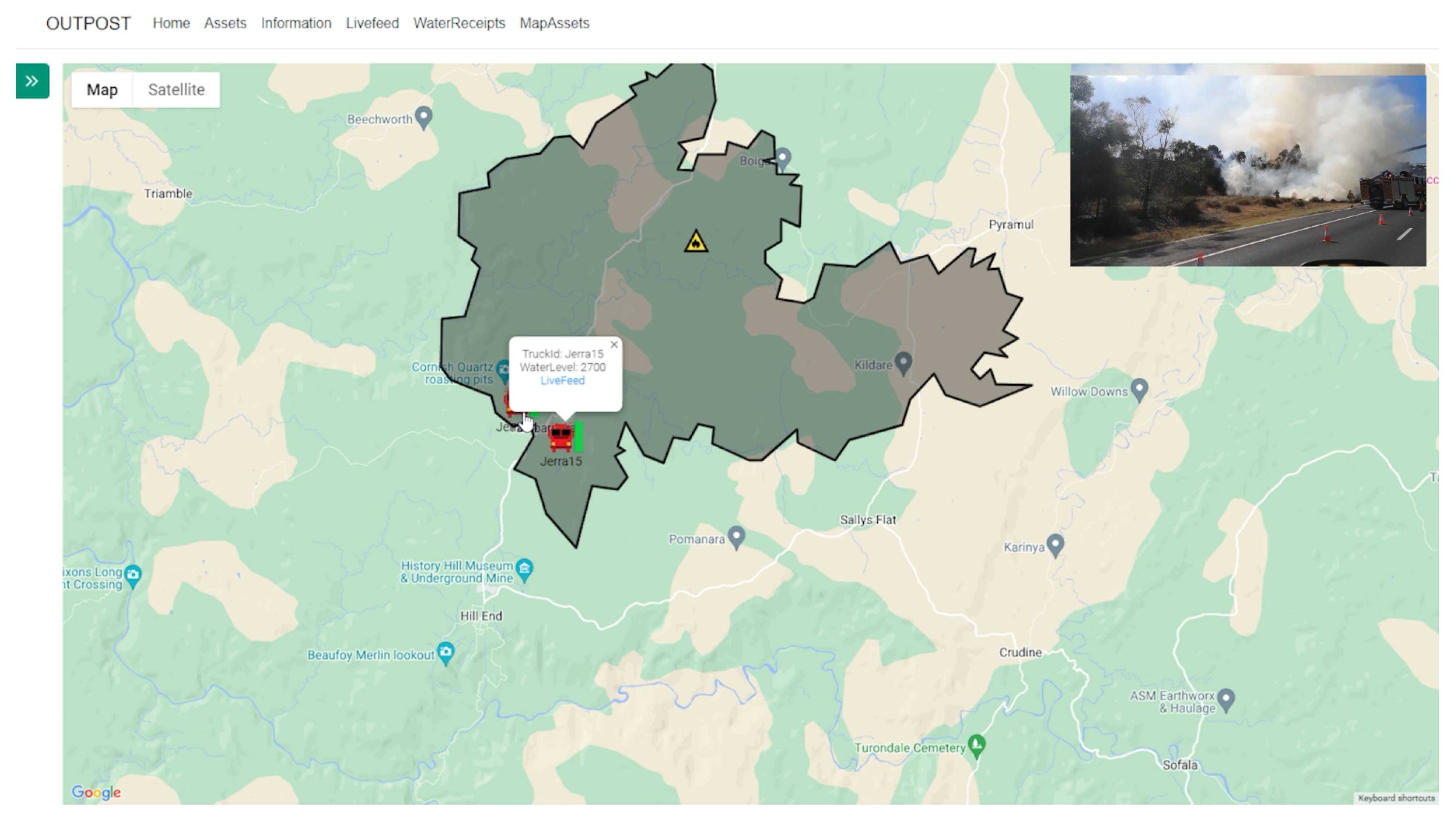
The Command-and-Control Interface Subsystem (CCIS) was successfully implemented as a web-based application that integrated data from all subsystems into a single operational platform (Figure 14). During field testing, the application provided a reliable, real-time geospatial view of vehicle locations via the GPS module, alongside water level updates transmitted from the MESS. In addition, the integration of the external NSW RFS Fires Near Me data feed was achieved, polling the public GeoJSON endpoint at five-minute intervals as described in the methodology. This ensured that both system-generated telemetry and authoritative fire updates were consolidated within one interface, enhancing situational awareness for command staff. The platform was successfully accessed on both desktop and mobile devices during trials, confirming its cross-platform compatibility and usability in field and office environments. Together, these outcomes demonstrate the CCIS’s capacity to act as a central decision-support tool, enabling crews to visualise operational status in real time and coordinate more effectively. Future development will focus on extending the interface with additional features, such as role-based access control, automated alert generation, and integration with other emergency service data streams. These enhancements will strengthen the CCIS as a scalable and field-ready tool for multi-agency coordination in firefighting operations.

4.4. Power Consumption and Battery Endurance Analysis

A theoretical power analysis was conducted to evaluate the operational endurance of the CVMS handheld device, which is powered by a 2000 mAh Li-Po battery. The analysis is based on component datasheets [27,28,29], summarised in Table 2, and considers two operational modes.
The current prototype operates in a Continuous Mode, where the OLED screen is always on for constant situational awareness. The total current draw is a sum of the components in Table 2, approximately 43.7 mA. The endurance in this mode ( T c o n t ) is calculated as:
T c o n t = 2000 mAh 43.7 mA 45 h
A proposed Power-Saving Mode for future iterations would keep the screen off until activated by a button press. This creates an idle state (screen off) drawing ∼18.7 mA and an active state (screen on) drawing 43.7 mA. Assuming a 25% active duty cycle for periodic checks, the average current ( I a v g ) becomes:
I a v g = ( 0.25 × 43.7 mA ) + ( 0.75 × 18.7 mA ) 25 mA
This design would extend the endurance ( T p s ) significantly:
T p s = 2000 mAh 25 mA 80 h
For in-field charging, the handheld device is designed to be recharged from the fire vehicle’s standard 12 V auxiliary power ports, ensuring continuous operation across multi-day deployments.
Finally, the Bangle.js smartwatch serves as the vital sign monitor, equipped with a 350 mAh battery and a heart rate sensor [30]. While the manufacturer specifies a one-week standby time, the OFMS requires continuous PPG sensing and Bluetooth transmission [30]. This high-drain usage significantly reduces the operational endurance to an estimated 24 to 36 h, which is sufficient for a full operational shift.

5. Discussions

The development and implementation of the integrated smart truck framework demonstrate a technically robust and field-relevant approach to enhancing situational awareness and safety in high-risk firefighting environments. The system comprises the Communication and Vital Monitoring Subsystem (CVMS), the Monitoring and Environmental Sensing Subsystem (MESS), and the Command-and-Control Interface Subsystem (CCIS). This multidisciplinary system showcases the synergy between embedded systems, wearable sensing technologies, long-range communications, environmental monitoring, and real-time data integration to address the unique challenges encountered in emergency response scenarios.
The CVMS significantly contributes to frontline safety by enabling real-time monitoring of firefighters’ vital signs via an unobtrusive smartwatch. The decision to adopt an open-source smartwatch platform (Bangle.js) provides a replicable, cost-effective, and customisable solution that avoids the limitations of proprietary systems. Although the current prototype focuses on heart rate monitoring, the smartwatch’s onboard sensors (e.g., accelerometer, GPS, and temperature) allow future expansion to multimodal physiological monitoring. Multimodal physiological monitoring has demonstrated improved accuracy in detecting stress, cognitive load, and pain [31,32,33]. Similar systems, such as PyroGuardian, have used wearable sensors and LoRa transmission to relay heart rate, temperature, and location data in field simulations [16,17]. Given that cardiac events are a leading cause of firefighter fatalities [34,35], early detection of fatigue and physiological distress is critical. Reviews also support the utility of wearables in predicting adverse health events during extended operations [9]. The modular design of the CVMS enables seamless adaptation to emerging physiological monitoring needs, supporting its evolution into a robust tool for real-time health risk mitigation in high-stress operational environments.
The MESS subsystem’s ultrasonic water level sensing with IMU-based tilt correction addresses a novel operational challenge. Ultrasonic sensors are widely used for non-contact level measurement but are sensitive to tilt [36]. Our modal-binning algorithm demonstrated robustness across 0–20° tilt angles, improving measurement fidelity in dynamic conditions. It is worth noting that tilt angles exceeding 20° are uncommon in real-world firefighting scenarios, as vehicles and portable equipment are typically stabilised during operation. Thus, our system design balances precision and practical deployment constraints. Comparable industrial sensors, such as Flowline Class 1 gauge and EchoPod [37], offer reliable performance but are typically suited to static, level installations and lack active tilt compensation features. Recent research on mobile ultrasonic systems has attempted to address dynamic measurement challenges using signal processing and machine learning. For instance, Terzic et al. [18] proposed a support vector machine (SVM)-based approach for ultrasonic liquid-level estimation in fuel tank of a vehicle, which compensates for sensor motion using supervised learning. Similarly, Sahoo et al. [19] explored adaptive estimation using artificial neural networks (ANN) to enhance accuracy of ultrasonic measurement systems. These ML-based approaches are primarily designed to learn and compensate for complex, non-linear fluid dynamics, such as water sloshing during vehicle motion. However, these systems require extensive training data, computational resources, and integration overhead. In contrast, our algorithm is a deterministic, geometric solution specifically optimised for the common operational challenge of static tilt (e.g., a vehicle parked on a slope), which it addresses without the need for training data. This modal-binning method provides a computationally lightweight and effective alternative, enabling real-time deployment on low-power embedded platforms. This design choice prioritises processing the volume calculation at the edge, allowing the final, lightweight result (water volume) to be transmitted quickly and efficiently to the firefighters’ handheld devices via the LoRa network. Therefore, a direct quantitative comparison is challenging, as the systems offer different architectural trade-offs: the ML-based systems target the more complex problem of dynamic motion at a high computational cost (which could, in future, be performed on our cloud platform using raw sensor data), while our system provides a robust, low-cost solution that delivers faster, safety-critical data directly to the end-user.
CCIS enables real-time and improved situational awareness for commanders. This subsystem consolidates data from the CVMS and MESS modules, along with external feeds such as the NSW RFS Fires Near Me API, into a secure, cloud-based dashboard. This integrated view supports rapid decision-making by correlating physiological data (e.g., heart rate), environmental conditions (e.g., water level, temperature, GPS), and live incident intelligence. Prior studies have highlighted the value of secure, cloud-connected dashboards in emergency response, particularly when coupled with IoT-enabled wearables and mobile edge computing [38]. For instance, Chark et al. [39] proposed a real-time firefighter monitoring system using encrypted MQTT pipelines and visualisation tools for real-time firefighter tracking in smoke-filled environments. Similarly, Qiu et al. [40] demonstrated a cloud-based platform for environmental and structural monitoring using smartphones to assist first responders. Compared to these approaches, our CCIS implementation focuses on modularity and interoperability, leveraging open-source frameworks for flexibility and reduced vendor dependencies. This cloud-based architecture is also inherently scalable; because each vehicle utilises an independent high-bandwidth Starlink connection, the system can support concurrent data ingestion from a large fleet without bandwidth contention. Encrypted communications are maintained using TLS protocols, with user-level access control to protect sensitive data (e.g., physiological data or GPS information). This architecture supports future extensibility, such as predictive analytics for crew fatigue or automated alerts triggered by geospatial or physiological thresholds.
The adoption of Starlink introduces several advantages crucial for the MESS framework, particularly in addressing connectivity limitations in remote or infrastructure-compromised areas. Starlink’s low Earth orbit (LEO) satellite constellation utilises an electronically steered phased-array antenna and a motorised, self-orienting dish (IP54-rated) [41], enabling robust and adaptable communication in diverse environmental conditions. This novel technology extends the reach of communication networks to areas previously inaccessible, enhancing the overall reliability and coverage of the MESS in diverse and challenging environments. Furthermore, improved Starlink connectivity brings a significant boost in data transmission speed, ensuring near-instant transfer of critical data [42]. This enhances system efficiency and responsiveness, underlining the importance of real-time data capture. Aligned with MESS system goals, this strategic shift supports optimal operation in dynamic environmental challenges. In the context of firefighting, this translates to improved situational awareness, facilitating quicker and more informed decision-making by incident commanders [43]. Transitioning from NB-IoT to Starlink satellite communication enhanced system performance by ensuring high-bandwidth and low-latency transmission in remote conditions [44]. This approach anticipates the growing trend of leveraging satellite networks for public safety, especially as cellular networks become unreliable during large-scale disasters.
Despite the promising capabilities of OFMS, several limitations must be acknowledged. Most notably, the system has yet to be validated in active firefighting scenarios, leaving its performance under real-world conditions—such as high temperatures, humidity, and radio frequency interference—untested. This validation gap also applies to the water-level monitoring sensor, which was evaluated using a small laboratory-scale tank and only under static tilt conditions. The system’s behaviour during dynamic vehicle motion, such as in “pump and roll” operations, remains unexplored. In these scenarios, water sloshing introduces significant measurement uncertainty, as the current algorithm assumes a stable, planar water surface. Although the existing modal-binning algorithm provides partial resilience to high-frequency vibration noise, compensating for sloshing effects would require more advanced filtering and predictive estimation methods; this remains a significant challenge for future development. The scalability of the system across multi-agency environments may also present interoperability challenges; differences in network infrastructure, communication standards, and data-sharing policies between agencies could complicate large-scale deployment, requiring further work to ensure robust and interoperable operation. Additionally, the system’s current physiological monitoring focuses solely on heart rate, limiting its ability to capture broader indicators of firefighter well-being. The prototype also lacks a dedicated fault-tolerance mechanism, such as software watchdogs or data-quality checks, to recover from sensor or network failures. It should also be noted that a direct comparison with existing systems is not straightforward, since current solutions differ substantially in sensing technologies, network architectures, and operational objectives, limiting the feasibility of a one-to-one performance evaluation.
Future research will aim to address these limitations through expanded field validation and enhanced sensing integration. The physiological subsystem will be extended to include additional parameters such as skin temperature, PPG-derived heart rate variability (HRV), and fatigue-related biomarkers, enabling more comprehensive health monitoring and predictive modelling using machine learning. The environmental sensing framework will incorporate gas sensors and smart textiles to further improve hazard detection and situational awareness. The communication architecture will also be strengthened through a hybrid design that leverages NB-IoT as a low-bandwidth failover to Starlink, ensuring continuous transmission of essential telemetry—such as GPS coordinates and water levels—during link interruptions. A quantitative evaluation of communication range, latency, and power efficiency across different network technologies (e.g., cellular and Wi-Fi mesh) will further substantiate OFMS’s operational robustness. Finally, insights from planned user experience studies with incident commanders and frontline responders will guide iterative system refinement, ensuring usability, reliability, and practical adoption in real-world firefighting operations.

6. Conclusions

This paper presents the design, development, and validation of the Operational Fire Management System (OFMS), a novel sensor-integrated framework. The primary contribution is the successful integration of three core subsystems (MESS, CVMS, and CCIS) which allow for accurate, tilt-compensated water level monitoring and open-source vital sign tracking via LoRa and provide a unified cloud-based command interface. Together, these components provide a practical and scalable solution for enhancing fireground situational awareness.
The OFMS is designed for deployment in challenging application scenarios, particularly rural and remote firefighting operations where connectivity is limited and real-time resource data is critical. Future work will focus on expanding the system’s capabilities. This includes enhancing the CCIS to support multi-vehicle coordination and integrating aerial data streams from UAVs for broader environmental awareness. Further development will also involve expanding the range of physiological sensors and conducting large-scale field validation in active fire scenarios to confirm operational resilience.

Author Contributions

Conceptualisation, D.K., R.O. and E.P.; methodology, D.K., R.O., E.P. and R.F.R.; software, D.K., R.O. and E.P.; validation, D.K., R.O., E.P. and R.F.R.; formal analysis, D.K., R.O., E.P., and R.F.R.; resources, D.K., R.O., E.P. and R.F.R.; writing—original draft preparation, D.K. and R.F.R.; writing—review and editing, D.K. and R.F.R.; visualisation, D.K.; supervision, R.F.R.; project administration, D.K. and R.F.R. All authors have read and agreed to the published version of the manuscript.

Funding

This research received no external funding.

Data Availability Statement

All data supporting this study are available upon request.

Acknowledgments

The authors gratefully acknowledge the support of the Australian Capital Territory Rural Fire Service (ACT RFS) in the development of the Operational Fire Management System (OFMS). Their collaboration and operational insights were instrumental in ensuring the system’s relevance and applicability.

Conflicts of Interest

The authors declare no conflicts of interest.

References

  1. Yu, P.; Xu, R.; Abramson, M.J.; Li, S.; Guo, Y. Bushfires in Australia: A serious health emergency under climate change. Lancet Planet. Health 2020, 4, e7–e8. [Google Scholar] [CrossRef]
  2. Illes, C.; Popa, G.N.; Filip, I. Water level control system using PLC and wireless sensors. In Proceedings of the 2013 IEEE 9th International Conference on Computational Cybernetics (ICCC), Tihany, Hungary, 8–10 July 2013; pp. 195–199. [Google Scholar]
  3. Yuliza, E.; Salam, R.; Amri, I.; Atmajati, E.; Hapidin, D.; Meilano, I.; Munir, M.; Abdullah, M. Characterization of a water level measurement system developed using a commercial submersible pressure transducer. In Proceedings of the 2016 International Conference on Instrumentation, Control and Automation (ICA), Bandung, Indonesia, 29–31 August 2016; pp. 99–102. [Google Scholar]
  4. Coca, A.; Roberge, R.J.; Williams, W.J.; Landsittel, D.P.; Powell, J.B.; Palmiero, A. Physiological monitoring in firefighter ensembles: Wearable plethysmographic sensor vest versus standard equipment. J. Occup. Environ. Hyg. 2009, 7, 109–114. [Google Scholar] [CrossRef]
  5. Bustos, D.; Guedes, J.; Santos Baptista, J.; Vaz, M.; Torres Costa, J.; Fernandes, R. Physiological monitoring systems for firefighters (A Short Review). In Occupational and Environmental Safety and Health III; Springer: Cham, Swizerland, 2021; pp. 293–305. [Google Scholar]
  6. Kozlovszky, M.; Pavlinić, D.Z. Environment and situation monitoring for firefighter teams. In Proceedings of the 2014 IEEE 15th International Symposium on Computational Intelligence and Informatics (CINTI), Budapest, Hungary, 19–21 November 2014; pp. 439–442. [Google Scholar]
  7. Le, T.; Huerta, M.; Moravec, A.; Cao, H. Wireless passive monitoring of electrocardiogram in firefighters. In Proceedings of the 2018 IEEE International Microwave Biomedical Conference (IMBioC), Philadelphia, PA, USA, 14–15 June 2018; pp. 121–123. [Google Scholar]
  8. Raj, J.V.; Sarath, T. An IoT based real-time stress detection system for fire-fighters. In Proceedings of the 2019 International Conference on Intelligent Computing and Control Systems (ICCS), Madurai, India, 15–17 May 2019; pp. 354–360. [Google Scholar]
  9. Pratas, P.; Bustos, D.; Guedes, J.; Mendes, J.; Baptista, J.S.; Vaz, M. Physiological Monitoring Systems for Fatigue Detection Within Firefighters: A Brief Systematic Review. In Occupational and Environmental Safety and Health IV; Springer: Cham, Swizerland, 2022; pp. 469–486. [Google Scholar]
  10. Scholz, M.; Gordon, D.; Ramirez, L.; Sigg, S.; Dyrks, T.; Beigl, M. A concept for support of firefighter frontline communication. Future Internet 2013, 5, 113–127. [Google Scholar] [CrossRef]
  11. Yizhe, Z. Design and implementation of firefighter signs monitoring system based on internet of things technology. In Proceedings of the 2021 International Conference on Intelligent Computing, Automation and Systems (ICICAS), Chongqing, China, 29–31 December 2021; pp. 151–154. [Google Scholar]
  12. Krishnamoorthy, M.; Asif, M.; Kumar, P.P.; Nuvvula, R.S.; Khan, B.; Colak, I. A Design and Development of the Smart Forest Alert Monitoring System Using IoT. J. Sens. 2023, 2023. [Google Scholar] [CrossRef]
  13. Prakash, C.; Barthwal, A.; Acharya, D. FLOODWALL: A Real-Time Flash Flood Monitoring and Forecasting System Using IoT. IEEE Sens. J. 2022, 23, 787–799. [Google Scholar] [CrossRef]
  14. Cicioğlu, M.; Calhan, A. Internet of Things-based firefighters for disaster case management. IEEE Sens. J. 2020, 21, 612–619. [Google Scholar] [CrossRef]
  15. Chehade, S.; Matta, N.; Pothin, J.B.; Cogranne, R. Data interpretation support in rescue operations: Application for French firefighters. In Proceedings of the 2018 IEEE/ACS 15th International Conference on Computer Systems and Applications (AICCSA), Aqaba, Jordan, 28 October–1 November 2018; pp. 1–6. [Google Scholar]
  16. Kaplan, B.; Li, B. PyroGuardian: An IoT-enabled system for health and location monitoring in high-risk firefighting environments. In Proceedings of the 2025 6th International Conference on Computing, Networks and Internet of Things (CNIOT), Shanghai, China, 23–25 May 2025; pp. 1–11. [Google Scholar]
  17. Lioliopoulos, P.; Oikonomou, P.; Boulougaris, G.; Kolomvatsos, K. Integrated portable and stationary health impact-monitoring system for firefighters. Sensors 2024, 24, 2273. [Google Scholar] [CrossRef] [PubMed]
  18. Terzic, J.; Nagarajah, C.; Alamgir, M. Fluid level measurement in dynamic environments using a single ultrasonic sensor and Support Vector Machine (SVM). Sens. Actuators A Phys. 2010, 161, 278–287. [Google Scholar] [CrossRef]
  19. Sahoo, A.K.; Udgata, S.K. A novel ANN-based adaptive ultrasonic measurement system for accurate water level monitoring. IEEE Trans. Instrum. Meas. 2019, 69, 3359–3369. [Google Scholar] [CrossRef]
  20. Sengupta, S. IoT-Based Flood Detection and Management Systems in Urban Areas. Risk Assess. Manag. Decis. 2024, 1, 301–313. [Google Scholar]
  21. Peng, Y.; Xiang, L.; Yang, K.; Jiang, F.; Wang, K.; Wu, D.O. Simac: A semantic-driven integrated multimodal sensing and communication framework. IEEE J. Sel. Areas Commun. 2025. [Google Scholar] [CrossRef]
  22. Luo, C.; Xiang, L.; Hu, J.; Yang, K. Algorithm Design and Prototype Validation for Reconfigurable Intelligent Sensing Surface: Forward-Only Transmission. arXiv 2025, arXiv:2503.23883. [Google Scholar] [CrossRef]
  23. Zhao, P.; Hu, D. Private and Effective Range Counting Query Over Evolving Data in Internet of Things. IEEE Trans. Mob. Comput. 2025, 24, 13488–13505. [Google Scholar] [CrossRef]
  24. Zhao, P.; Wu, J.; Zhang, G. Road Network-Aware and Differentially Private Framework for Location and Location Histogram. IEEE Trans. Intell. Transp. Syst. 2025, 26, 16348–16360. [Google Scholar] [CrossRef]
  25. Radiocommunications Act. Radiocommunications (Low Interference Potential Devices) Class Licence 2000. 1992. Available online: https://www.legislation.gov.au/C2004A04465/latest/versions (accessed on 29 September 2025).
  26. Van Laerhoven, K.; Hoelzemann, A.; Pahmeier, I.; Teti, A.; Gabrys, L. Validation of an open-source ambulatory assessment system in support of replicable activity studies. Ger. J. Exerc. Sport Res. 2022, 52, 262–272. [Google Scholar] [CrossRef]
  27. Arduino AG. Arduino Nano 33 BLE Rev2 User Manual; Arduino AG: Lugano, Switzerland, 2025; SKU: ABX00071. Datasheet modified 29/09/2025. [Google Scholar]
  28. Adafruit Industries. Monochrome 1.3″ 128 × 64 OLED Graphic Display—STEMMA QT/Qwiic. 2025. Product ID 938. Available online: https://www.adafruit.com/product/938 (accessed on 30 September 2025).
  29. Seeed Technology Co., Ltd. LoRa-E5 Datasheet V1.0. Seeed Studio, 2020. Available online: https://files.seeedstudio.com/products/317990687/res/LoRa-E5+module+datasheet_V1.0.pdf (accessed on 1 October 2025).
  30. Adafruit Industries. Bangle.js Hackable Javascript Smart Watch Product Overview. 2022. Available online: https://www.mouser.com/new/adafruit/adafruit-bangle-js-watch/ (accessed on 2 October 2025).
  31. Hirachan, N.; Mathews, A.; Romero, J.; Rojas, R.F. Measuring cognitive workload using multimodal sensors. In Proceedings of the 2022 44th Annual International Conference of the IEEE Engineering in Medicine & Biology Society (EMBC), Glasgow, UK, 11–15 July 2022; pp. 4921–4924. [Google Scholar]
  32. Fernandez Rojas, R.; Hirachan, N.; Brown, N.; Waddington, G.; Murtagh, L.; Seymour, B.; Goecke, R. Multimodal physiological sensing for the assessment of acute pain. Front. Pain Res. 2023, 4, 1150264. [Google Scholar] [CrossRef]
  33. Webber, M.; Rojas, R.F. Human activity recognition with accelerometer and gyroscope: A data fusion approach. IEEE Sens. J. 2021, 21, 16979–16989. [Google Scholar] [CrossRef]
  34. Kales, S.N.; Soteriades, E.S.; Christoudias, S.G.; Christiani, D.C. Firefighters and on-duty deaths from coronary heart disease: A case control study. Environ. Health 2003, 2, 14. [Google Scholar] [CrossRef]
  35. Smith, D.L.; Barr, D.A.; Kales, S.N. Extreme sacrifice: Sudden cardiac death in the US Fire Service. Extrem. Physiol. Med. 2013, 2, 6. [Google Scholar] [CrossRef]
  36. Rajalakshmy, P.; Subha Hency Jose, P.; Rajasekaran, K.; Varun, R.; Sweety Jose, P. A novel sensing technique for continuous monitoring of volume in an automobile fuel tank. In E-Mobility: A New Era in Automotive Technology; Springer: Berlin/Heidelberg, Germany, 2021; pp. 243–257. [Google Scholar]
  37. Flowline Inc. EchoPod DL24 Multi-Function Ultrasonic Liquid Level Transmitter. 2025. Available online: https://www.flowline.com/product/echopod-dl24-multi-function-ultrasonic-liquid-level-transmitter/ (accessed on 29 July 2025).
  38. Abbas, N.; Zhang, Y.; Taherkordi, A.; Skeie, T. Mobile edge computing: A survey. IEEE Internet Things J. 2017, 5, 450–465. [Google Scholar] [CrossRef]
  39. See, Y.C.; Ho, E.X. IoT-based fire safety system using MQTT communication protocol. Int. J. Integr. Eng. 2020, 12, 207–215. [Google Scholar]
  40. Qiu, M.; Ming, Z.; Wang, J.; Yang, L.T.; Xiang, Y. Enabling cloud computing in emergency management systems. IEEE Cloud Comput. 2014, 1, 60–67. [Google Scholar] [CrossRef]
  41. Lagunas, E.; Chatzinotas, S.; Ottersten, B. Low-Earth orbit satellite constellations for global communication network connectivity. Nat. Rev. Electr. Eng. 2024, 1, 656–665. [Google Scholar] [CrossRef]
  42. Shaengchart, Y.; Kraiwanit, T. Starlink satellite project impact on the Internet provider service in emerging economies. Res. Glob. 2023, 6, 100132. [Google Scholar] [CrossRef]
  43. Damaševičius, R.; Bacanin, N.; Misra, S. From sensors to safety: Internet of Emergency Services (IoES) for emergency response and disaster management. J. Sens. Actuator Networks 2023, 12, 41. [Google Scholar] [CrossRef]
  44. Su, Y.; Liu, Y.; Zhou, Y.; Yuan, J.; Cao, H.; Shi, J. Broadband LEO satellite communications: Architectures and key technologies. IEEE Wirel. Commun. 2019, 26, 55–61. [Google Scholar] [CrossRef]
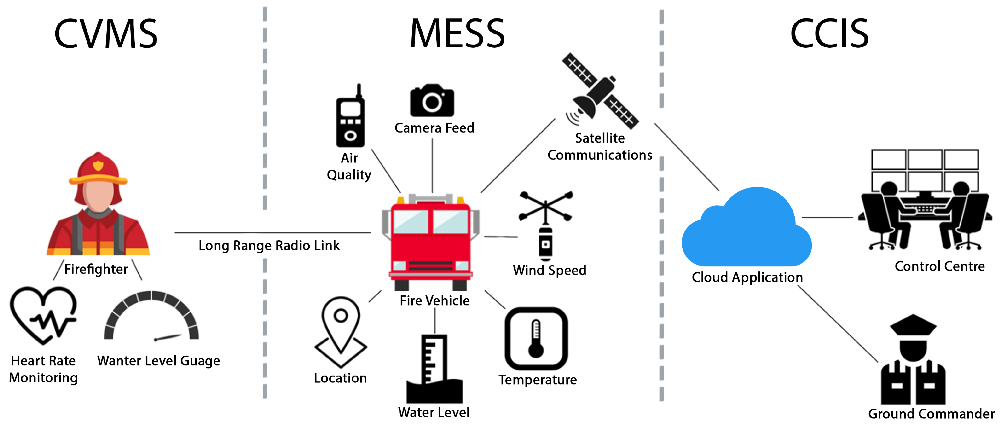
Figure 1. Overview of the proposed architecture and its three subsystems: Communication and Vital Monitoring Subsystem (CVMS), Monitoring and Environmental Sensing Subsystem (MESS), and Command-and-Control Interface Subsystem (CCIS).
Jsan 14 00114 g001
Figure 2. Architecture of the Communication and Vital Monitoring Subsystem (CVMS). The schematic details the internal components of the handheld unit, including the OLED display, input controls, power management, and LoRa-E5 module. It also illustrates the dual wireless interfaces: a Bluetooth Low Energy (BLE) link to the wearable smartwatch and a LoRa connection for long-range telemetry with the fire vehicle.
Jsan 14 00114 g002
Figure 3. Architecture of the Monitoring and Environmental Sensing Subsystem (MESS). The diagram illustrates the hardware integration, detailing the data flow from the ultrasonic water level sensor, IMU, and environmental sensors through the central processing unit to the Starlink communication interface.
Jsan 14 00114 g003
Figure 4. Visual decomposition of the volume calculation methodology. Top-Left: The final calculated water volume ( V water ) shown in blue. Top-Right: The vertical displacement components derived from the tank length (L), width (W), and the measured pitch ( θ x ) and roll ( θ y ) angles. Bottom-Left: The isolated empty prism ( V prism ), representing the unoccupied space above the highest water point. Bottom-Right: The isolated empty wedge ( V wedge ), representing the corrective volume required to account for the tilted fluid surface.
Jsan 14 00114 g004
Figure 5. Architecture of the Command-and-Control Interface Subsystem (CCIS). The schematic depicts the end-to-end data pipeline, tracing the transmission of telemetry from the vehicle via Starlink (left), through the AWS cloud-based processing backend (center), to the final visualization on the web application dashboard (right).
Jsan 14 00114 g005
Figure 6. Development of the handheld prototype, showcasing the iterative design refinements to optimise component spacing. Left panel illustrates the 3D printing process; middle panel displays the assembled electronics; and right panel presents the finalised prototype.
Jsan 14 00114 g006
Figure 7. An example of a firefighter wearing the smartwatch for physiological monitoring and carrying the handheld device for communication and data transmission during field testing.
Jsan 14 00114 g007
Figure 8. A 10-s segment of a smoothed PPG signal from the Bangel.js. Detected heartbeats marked with a red ‘x’ at the signal peaks, and the calculated average heart rate for the interval displayed in the top-left.
Jsan 14 00114 g008
Figure 9. The ultrasonic sensor mounted to a custom aluminium angle bracket, being test-fitted inside the top-fill hatch of an operational fire truck.
Jsan 14 00114 g009
Figure 10. A 3D model of the 18.0 Litre test tank illustrating the calculated water volume, showing the off-centre ultrasonic sensor, its projected 30-degree detection cone, and the resulting slanted water surface.
Jsan 14 00114 g010
Figure 11. A comparison of the data distribution for the tilt-corrected and non-tilt-corrected volume calculations for the 5L dataset. The vertical dotted red line indicating the true volume.
Jsan 14 00114 g011
Figure 12. Root Mean Square Error (RMSE) by tilt angle group. The chart comparing the performance of the model with and without tilt correction, showing the significant error reduction at higher tilt angles.
Jsan 14 00114 g012
Figure 13. Frequency distribution of the final tilt-corrected volume readings. The dominant cluster of readings centred correctly around the true volume of 5.0L.
Jsan 14 00114 g013
Figure 14. Screenshot of the CCIS web application, which visualises both live system test data (vehicle location) and external NSW RFS incident data on the map interface.
Jsan 14 00114 g014
Table 1. Comparative overview of prior work and the proposed Operational Fire Management System (OFMS) advancements.
DimensionPrior WorkOFMS
Scope and IntegrationExisting studies addressed separate components, wearable monitoring [4,8,17], water-level sensing [2,3,18], or IoT hazard detection [12,13,14,20], without cross-domain integration.OFMS unifies three interoperable subsystems (MESS, CVMS, CCIS) into a single framework that merges physiological, environmental, and operational data for end-to-end coordination.
Water-Level Monitoring AccuracyTraditional float gauges and static ultrasonic or pressure-based sensors [2,3] fail under vehicle motion; ML-based systems [18,19] improve accuracy but demand high computational resources.OFMS employs IMU-based tilt estimation and a lightweight modal-binning algorithm to deliver real-time, tilt-corrected measurements deployable on embedded microcontrollers.
Physiological SensingWearable solutions such as plethysmographic vests [4] or IoT stress detectors [8] proved feasibility but used proprietary, single-metric devices lacking integration with command systems.OFMS introduces an open-source smartwatch (Bangle.js) with LoRa connectivity for extensible, replicable physiological monitoring integrated directly with communication and command modules.
Situational Awareness InterfaceIoT-based disaster systems [12,13,20] provide localised hazard data but lack unified dashboards linking firefighter vitals, vehicle resources, and incident intelligence.OFMS consolidates all subsystems within an AWS-hosted web interface, enabling commanders to visualise water availability, environmental conditions, and firefighter status in real time.
Table 2. Estimated Power Consumption of Handheld Device Components.
ComponentFunctionCurrent Draw
Arduino Nano 33 BLEMCU & BLE Radio∼12 mA
1.3″ OLED ScreenActive Display∼25 mA
LoRa-E5 ModuleRX/Listen Mode∼6.7 mA
Disclaimer/Publisher’s Note: The statements, opinions and data contained in all publications are solely those of the individual author(s) and contributor(s) and not of MDPI and/or the editor(s). MDPI and/or the editor(s) disclaim responsibility for any injury to people or property resulting from any ideas, methods, instructions or products referred to in the content.