Random Forest-Based Landslide Susceptibility Mapping in Coastal Regions of Artvin, Turkey


Abstract
:
1. Introduction
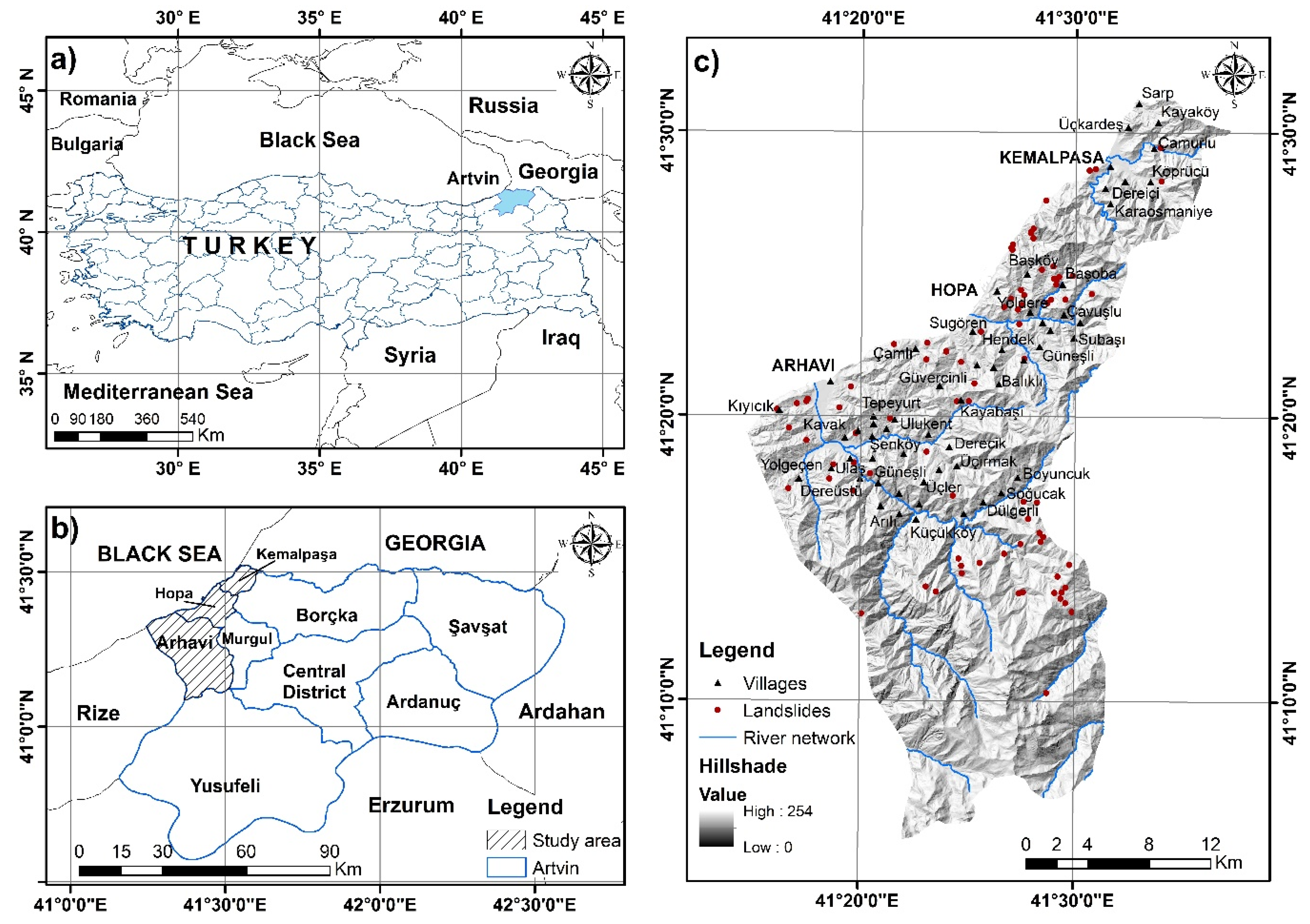
2. Characteristics of the Study Area
3. Materials and Methods
3.1. Data Used
3.2. Landslide Inventory
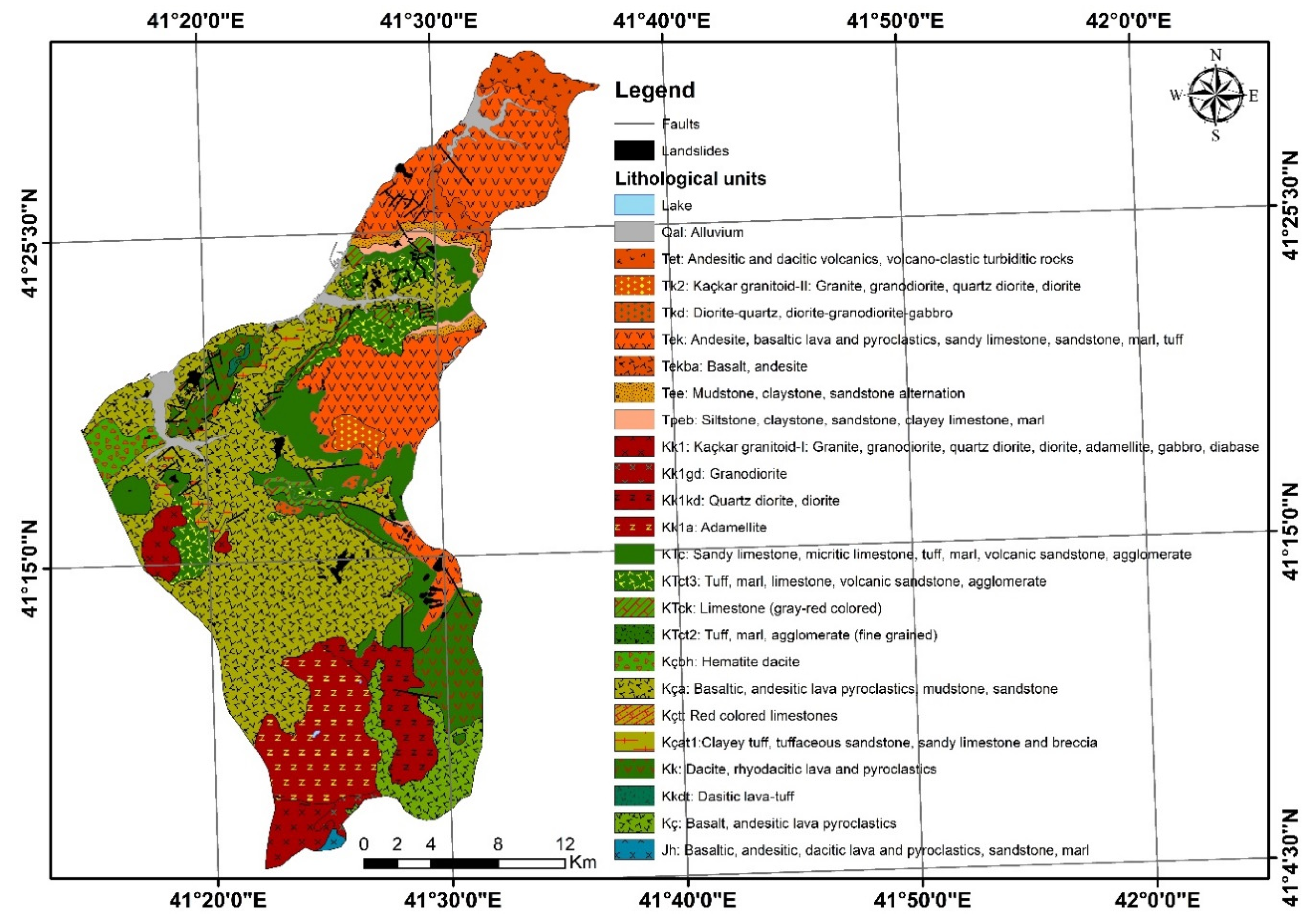
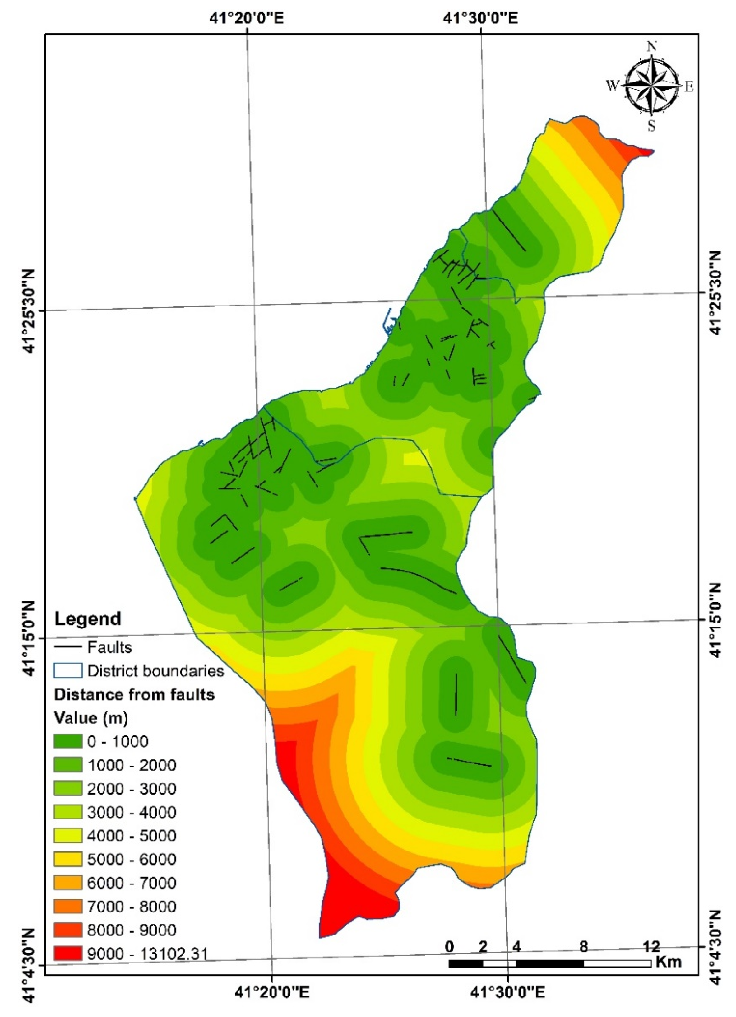
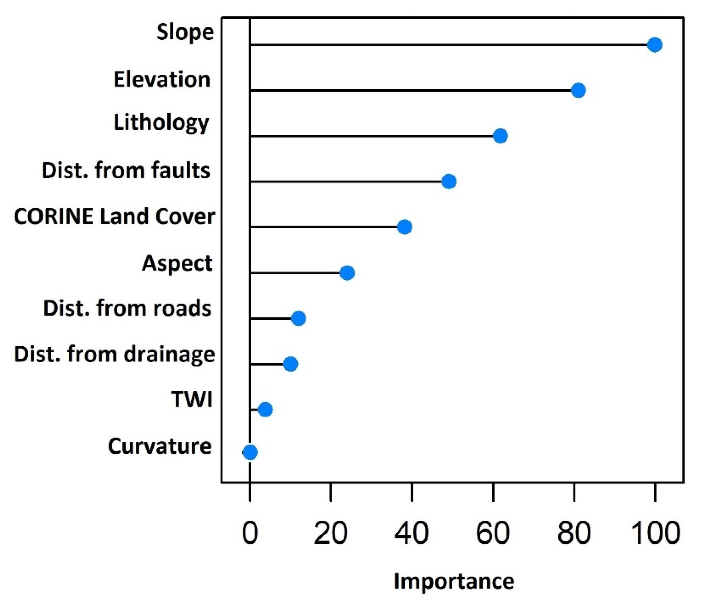
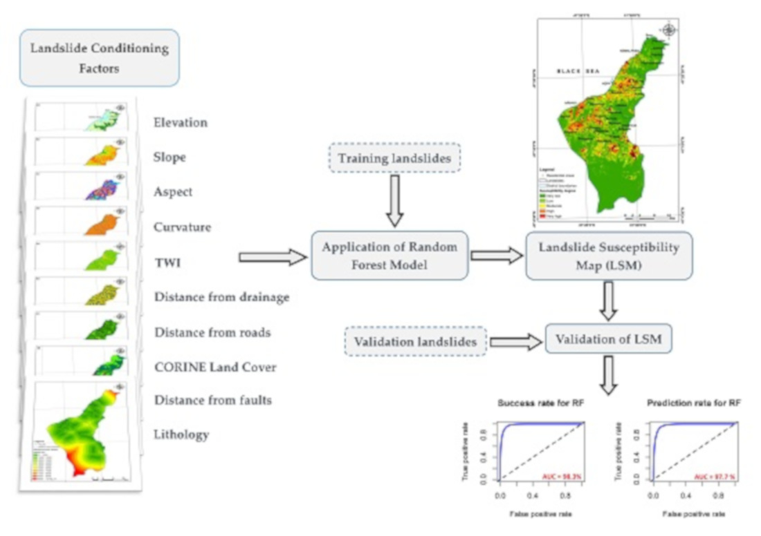
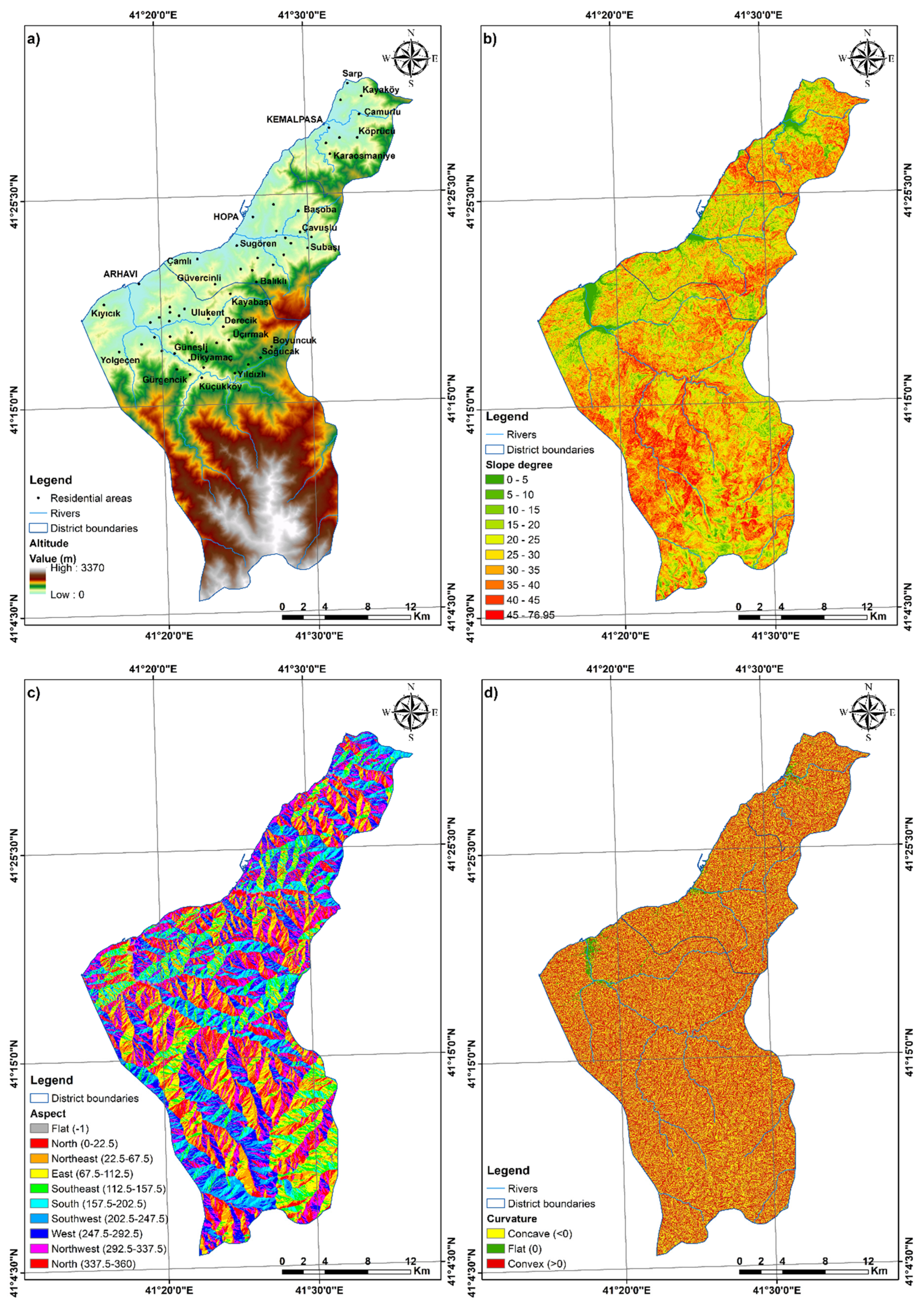
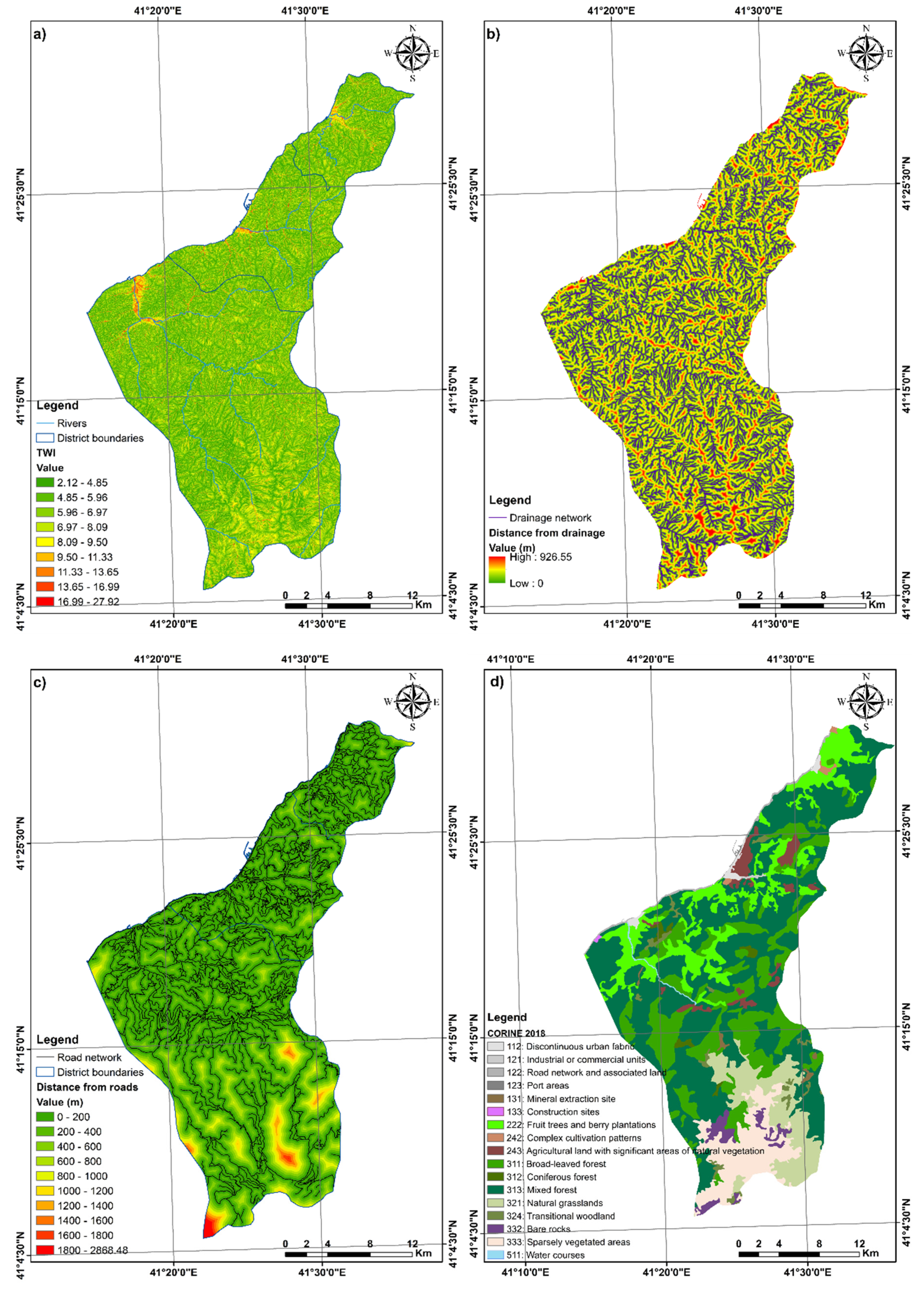
3.3. Landslide-Conditioning Factors
3.4. Landslide Susceptibility Assessment Using Random Forest (RF) Model
4. Results and Discussions
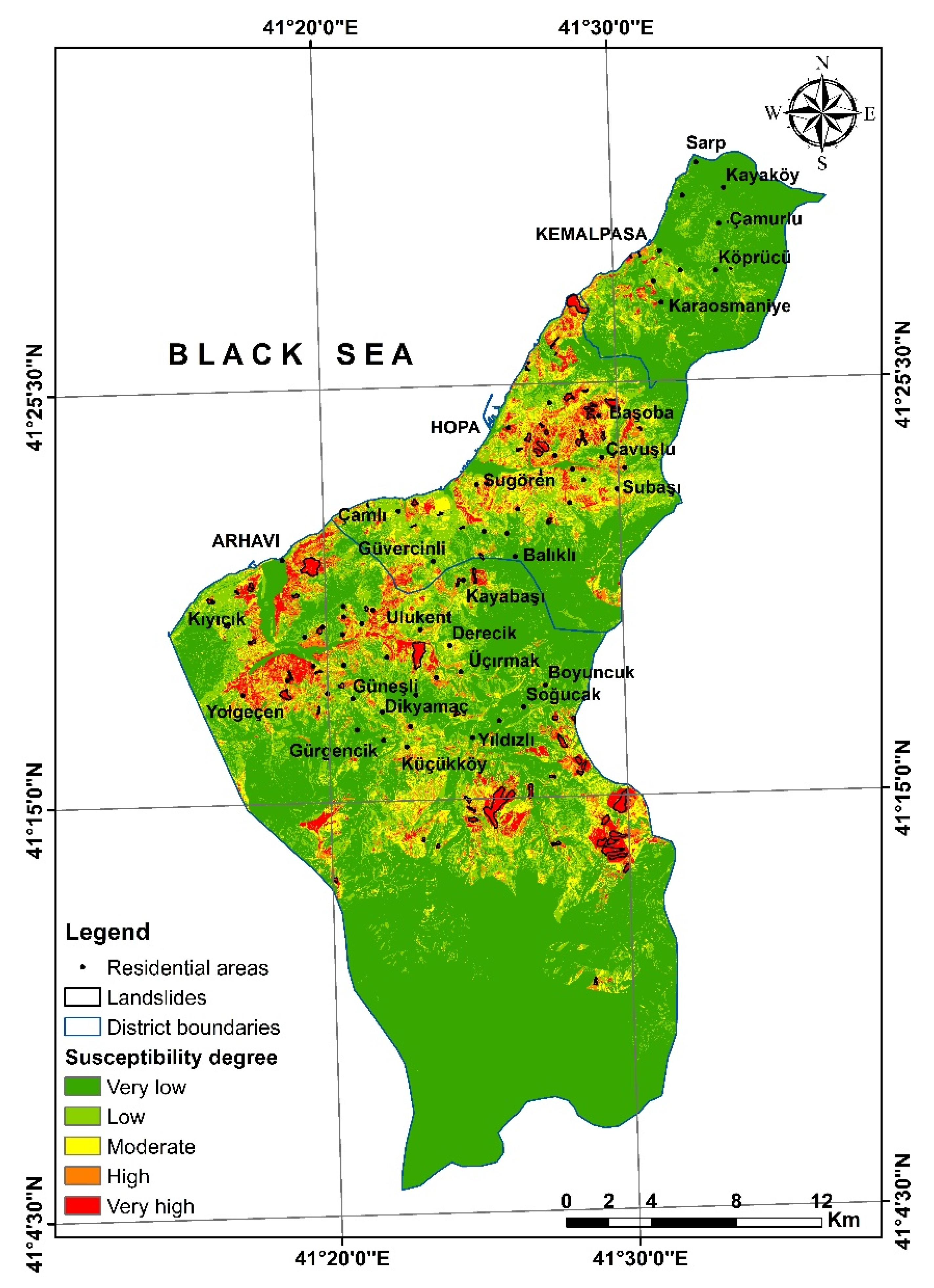
4.1. Landslide Susceptibility Mapping Results
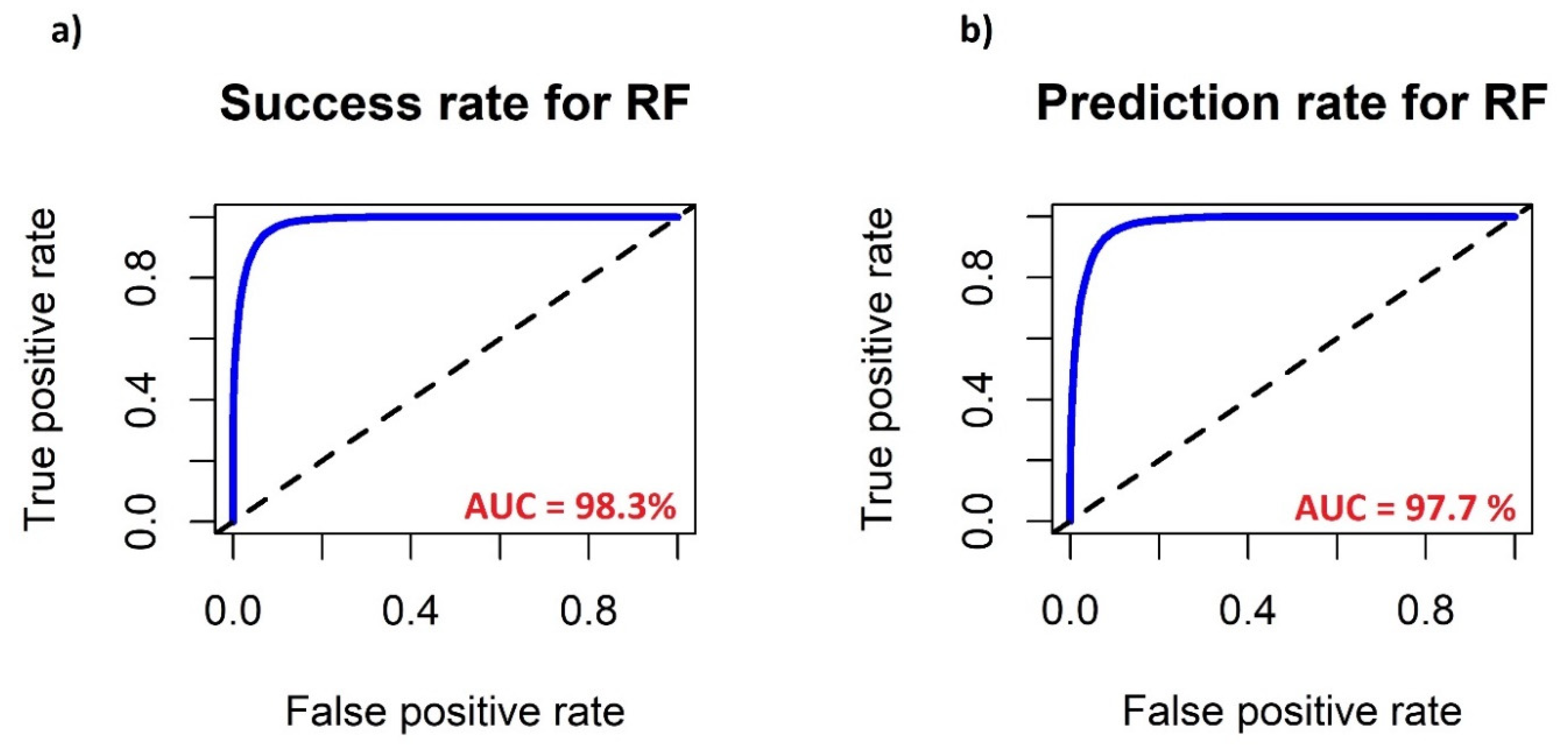
4.2. Model Performance and Validation
5. Conclusions
Author Contributions
Funding
Conflicts of Interest
References
- Akgun, A.; Dag, S.; Bulut, F. Landslide susceptibility mapping for a landslide-prone area (Findikli, NE of Turkey) by likelihood-frequency ratio and weighted linear combination models. Environ. Geol. 2008, 54, 1127–1143. [Google Scholar] [CrossRef]
- Aksoy, G. Landslide Susceptibility Analysis of Arhavi Region (Artvin). Master’s Thesis, Karadeniz echnical University, Trabzon, Turkey, 2011. (In Turkish). [Google Scholar]
- Yalcin, A.; Reis, S.; Aydinoglu, A.C.; Yomralioglu, T. A GIS-based comparative study of frequency ratio, analytical hierarchy process, bivariate statistics and logistics regression methods for landslide susceptibility mapping in Trabzon, NE Turkey. Catena 2011, 85, 274–287. [Google Scholar] [CrossRef]
- Çan, T.; Bulut, İ.; Tekin, S.; Özcan, A.K. Landslide hazard maps of the watersheds along the coastline between Gülyali (Ordu)—Bulancak (Giresun). In Proceedings of the 70th Geological Congress of Turkey, Ankara, Turkey, 10–14 April 2017; pp. 184–185. [Google Scholar]
- Zhao, Y.; Wang, R.; Jiang, Y.; Liu, H.; Wei, Z. GIS-based logistic regression for rainfall-induced landslide susceptibility mapping under different grid sizes in Yueqing, Southeastern China. Eng. Geol. 2019, 259, 105147. [Google Scholar] [CrossRef]
- Carabella, C.; Miccadei, E.; Paglia, G.; Sciarra, N. Post-Wildfire Landslide Hazard Assessment: The Case of the 2017 Montagna Del Morrone Fire (Central Apennines, Italy). Geosciences 2019, 9, 175. [Google Scholar] [CrossRef] [Green Version]
- Marsala, V.; Galli, A.; Paglia, G.; Miccadei, E. Landslide Susceptibility Assessment of Mauritius Island (Indian Ocean). Geosciences 2019, 9, 493. [Google Scholar] [CrossRef] [Green Version]
- Sevgen, E.; Kocaman, S.; Nefeslioglu, H.A.; Gokceoglu, C. A Novel Performance Assessment Approach Using Photogrammetric Techniques for Landslide Susceptibility Mapping with Logistic Regression, ANN and Random Forest. Sensors 2019, 19, 3940. [Google Scholar] [CrossRef] [Green Version]
- Karakas, G.; Can, R.; Kocaman, S.; Nefeslioglu, H.A.; Gokceoglu, C. Landslide Susceptibility Mapping with Random Forest Model for Ordu, Turkey. Int. Arch. Photogramm. Remote. Sens. Spat. Inf. Sci. 2020, 43, 1229–1236. [Google Scholar]
- Trigila, A.; Iadanza, C.; Esposito, C.; Scarascia-Mugnozza, G. Comparison of logistic regression and random forests techniques for shallow landslide susceptibility assessment in Giampilieri (NE Sicily, Italy). Geomorphology 2015, 249, 119–136. [Google Scholar] [CrossRef]
- Vakhshoori, V.; Zare, M. Landslide susceptibility mapping by comparing weight of evidence, fuzzy logic, and frequency ratio methods. Geomat. Nat. Hazards Risk 2016, 7, 1731–1752. [Google Scholar] [CrossRef]
- Pourghasemi, H.R.; Mohammady, M.; Pradhan, B. Landslide susceptibility mapping using index of entropy and conditional probability models in GIS: Safarood Basin, Iran. Catena 2012, 97, 71–84. [Google Scholar] [CrossRef]
- Luo, W.; Liu, C.C. Innovative landslide susceptibility mapping supported by geomorphon and geographical detector methods. Landslides 2018, 15, 465–474. [Google Scholar] [CrossRef]
- Wang, G.; Chen, X.; Chen, W. Spatial Prediction of Landslide Susceptibility Based on GIS and Discriminant Functions. ISPRS Int. J. Geo-Inf. 2020, 9, 144. [Google Scholar] [CrossRef] [Green Version]
- Reichenbach, P.; Rossi, M.; Malamud, B.D.; Mihir, M.; Guzzetti, F. A review of statistically-based landslide susceptibility models. Earth-Sci. Rev. 2018, 180, 60–91. [Google Scholar] [CrossRef]
- Yilmaz, I. Landslide susceptibility mapping using frequency ratio, logistic regression, artificial neural networks and their comparison: A case study from Kat landslides (Tokat—Turkey). Comput. Geosci. 2009, 35, 1125–1138. [Google Scholar] [CrossRef]
- Bai, S.-B.; Wang, J.; Lü, G.-N.; Zhou, P.-G.; Hou, S.-S.; Xu, S.-N. GIS-based logistic regression for landslide susceptibility mapping of the Zhongxian segment in the Three Gorges area, China. Geomorphology 2010, 115, 23–31. [Google Scholar] [CrossRef]
- Pradhan, B.; Lee, S. Landslide susceptibility assessment and factor effect analysis: Backpropagation artificial neural networks and their comparison with frequency ratio and bivariate logistic regression modelling. Environ. Model. Softw. 2010, 25, 747–759. [Google Scholar] [CrossRef]
- Bai, S.; Lu, P.; Wang, J. Landslide susceptibility assessment of the Youfang catchment using logistic regression. J. Mt. Sci 2015, 12, 816–827. [Google Scholar] [CrossRef]
- Chen, T.; Niu, R.; Jia, X. A comparison of information value and logistic regression models in landslide susceptibility mapping by using GIS. Environ. Earth Sci. 2016, 75, 867. [Google Scholar] [CrossRef]
- Du, G.-L.; Zhang, Y.-S.; Iqbal, J.; Yang, Z.-H.; Yao, X. Landslide susceptibility mapping using an integrated model of information value method and logistic regression in the Bailongjiang watershed, Gansu Province, China. J. Mt. Sci. 2017, 14, 249–268. [Google Scholar] [CrossRef]
- Pourghasemi, H.R.; Gayen, A.; Park, S.; Lee, C.-W.; Lee, S. Assessment of Landslide-Prone Areas and Their Zonation Using Logistic Regression, LogitBoost, and NaïveBayes Machine-Learning Algorithms. Sustainability 2018, 10, 3697. [Google Scholar] [CrossRef] [Green Version]
- Shou, K.-J.; Lin, J.-F. Evaluation of the extreme rainfall predictions and their impact on landslide susceptibility in a sub-catchment scale. Eng. Geol. 2020, 265, 105434. [Google Scholar] [CrossRef]
- Lee, S.; Pradhan, B. Landslide hazard mapping at Selangor, Malaysia using frequency ratio and logistic regression models. Landslides 2007, 4, 33–41. [Google Scholar] [CrossRef]
- Ozdemir, A.; Altural, T. A comparative study of frequency ratio, weights of evidence and logistic regression methods for landslide susceptibility mapping: Sultan Mountains, SW Turkey. J. Asian Earth Sci. 2013, 64, 180–197. [Google Scholar] [CrossRef]
- Shahabi, H.; Khezri, S.; Bin Ahmad, B.; Hashim, M. Landslide susceptibility mapping at central Zab basin, Iran: A comparison between analytical hierarchy process, frequency ratio and logistic regression models. Catena 2014, 115, 55–70. [Google Scholar] [CrossRef]
- Tasoglu, I.K.; Keskin Citiroglu, H.; Mekik, C. GIS-based landslide susceptibility assessment: A case study in Kelemen Valley (Yenice—Karabuk, NW Turkey). Environ. Earth Sci. 2016, 75, 1291. [Google Scholar] [CrossRef]
- Ding, Q.; Chen, W.; Hong, H. Application of frequency ratio, weights of evidence and evidential belief function models in landslide susceptibility mapping. Geocarto Int. 2017, 32, 619–639. [Google Scholar] [CrossRef]
- Hong, H.; Chen, W.; Xu, C.; Youssef, A.M.; Pradhan, B.; Bui, D.T. Rainfall-induced landslide susceptibility assessment at the Chongren area (China) using frequency ratio, certainty factor, and index of entropy. Geocarto Int. 2017, 32, 139–154. [Google Scholar] [CrossRef]
- Khan, H.; Shafique, M.; Khan, M.A.; Bacha, M.A.; Shah, S.U.; Calligaris, C. Landslide susceptibility assessment using Frequency Ratio, a case study of northern Pakistan. Egypt. J. Remote. Sens. Space Sci. 2019, 22, 11–24. [Google Scholar] [CrossRef]
- Zhou, C.; Yin, K.; Cao, Y.; Ahmed, B.; Li, Y.; Catani, F.; Pourghasemi, H.R. Landslide susceptibility modeling applying machine learning methods: A case study from Longju in the Three Gorges Reservoir area, China. Comput. Geosci. 2018, 112, 23–37. [Google Scholar] [CrossRef] [Green Version]
- Soma, A.S.; Kubota, T.; Mizuno, H. Optimization of causative factors using logistic regression and artificial neural network models for landslide susceptibility assessment in Ujung Loe Watershed, South Sulawesi Indonesia. J. Mt. Sci. 2019, 16, 383–401. [Google Scholar] [CrossRef]
- Pourghasemi, H.R.; Rahmati, O. Prediction of the landslide susceptibility: Which algorithm, which precision? Catena 2018, 162, 177–192. [Google Scholar] [CrossRef]
- Hu, Q.; Zhou, Y.; Wang, S.; Wang, F. Machine learning and fractal theory models for landslide susceptibility mapping: Case study from the Jinsha River Basin. Geomorphology 2020, 351, 106975. [Google Scholar] [CrossRef]
- Hong, H.; Pourghasemi, H.R.; Pourtaghi, Z.S. Landslide susceptibility assessment in Lianhua County (China): A comparison between a random forest data mining technique and bivariate and multivariate statistical models. Geomorphology 2016, 259, 105–118. [Google Scholar] [CrossRef]
- Huang, Y.; Zhao, L. Review on landslide susceptibility mapping using support vector machines. Catena 2018, 165, 520–529. [Google Scholar] [CrossRef]
- Bui, D.T.; Tsangaratos, P.; Nguyen, V.-T.; Liem, N.V.; Trinh, P.T. Comparing the prediction performance of a Deep Learning Neural Network model with conventional machine learning models in landslide susceptibility assessment. Catena 2020, 188, 104426. [Google Scholar] [CrossRef]
- Chen, T.; Zhu, L.; Niu, R.-Q.; Trinder, C.J.; Peng, L.; Lei, T. Mapping landslide susceptibility at the Three Gorges Reservoir, China, using gradient boosting decision tree, random forest and information value models. J. Mt. Sci. 2020, 17, 670–685. [Google Scholar] [CrossRef]
- Wu, Y.; Ke, Y.; Chen, Z.; Liang, S.; Zhao, H.; Hong, H. Application of alternating decision tree with AdaBoost and bagging ensembles for landslide susceptibility mapping. Catena 2020, 187, 104396. [Google Scholar] [CrossRef]
- Dou, J.; Yunus, A.P.; Tien Bui, D.; Merghadi, A.; Sahana, M.; Zhu, Z.; Chen, C.-W.; Khosravi, K.; Yang, Y.; Pham, B.T. Assessment of advanced random forest and decision tree algorithms for modeling rainfall-induced landslide susceptibility in the Izu-Oshima Volcanic Island, Japan. Sci. Total Environ. 2019, 662, 332–346. [Google Scholar] [CrossRef]
- Hong, H.; Miao, Y.; Liu, J.; Zhu, A.-X. Exploring the effects of the design and quantity of absence data on the performance of random forest-based landslide susceptibility mapping. Catena 2019, 176, 45–64. [Google Scholar] [CrossRef]
- Sun, D.; Wen, H.; Wang, D.; Xu, J. A random forest model of landslide susceptibility mapping based on hyperparameter optimization using Bayes algorithm. Geomorphology 2020, 362, 107201. [Google Scholar] [CrossRef]
- Merghadi, A.; Yunus, A.P.; Dou, J.; Whiteley, J.; ThaiPham, B.; Tien Bui, D.; Avtar, R.; Abderrahmane, B. Machine learning methods for landslide susceptibility studies: A comparative overview of algorithm performance. Earth-Sci. Rev. 2020, 207, 103225. [Google Scholar] [CrossRef]
- Chen, W.; Xie, X.; Wang, J.; Pradhan, B.; Hong, H.; Tien Bui, D.; Duan, Z.; Ma, J. A comparative study of logistic model tree, random forest, and classification and regression tree models for spatial prediction of landslide susceptibility. Catena 2017, 151, 147–160. [Google Scholar] [CrossRef] [Green Version]
- Achour, Y.; Pourghasemi, H.R. How do machine learning techniques help in increasing accuracy of landslide susceptibility maps? Geosci. Front. 2020, 11, 871–883. [Google Scholar] [CrossRef]
- Dou, J.; Yunus, A.P.; Merghadi, A.; Shirzadi, A.; Nguyen, H.; Hussain, Y.; Avtar, R.; Chen, Y.; Pham, B.T.; Yamagishi, H. Different sampling strategies for predicting landslide susceptibilities are deemed less consequential with deep learning. Sci. Total Environ. 2020, 720, 137320. [Google Scholar] [CrossRef] [PubMed]
- Wang, Y.; Fang, Z.; Hong, H. Comparison of convolutional neural networks for landslide susceptibility mapping in Yanshan County, China. Sci. Total Environ. 2019, 666, 975–993. [Google Scholar] [CrossRef] [PubMed]
- Sameen, M.I.; Pradhan, B.; Lee, S. Application of convolutional neural networks featuring Bayesian optimization for landslide susceptibility assessment. Catena 2020, 186, 104249. [Google Scholar] [CrossRef]
- Fang, Z.; Wang, Y.; Peng, L.; Hong, H. Integration of convolutional neural network and conventional machine learning classifiers for landslide susceptibility mapping. Comput. Geosci. 2020, 139, 104470. [Google Scholar] [CrossRef]
- Yi, Y.; Zhang, Z.; Zhang, W.; Jia, H.; Zhang, J. Landslide susceptibility mapping using multiscale sampling strategy and convolutional neural network: A case study in Jiuzhaigou region. Catena 2020, 195, 104851. [Google Scholar] [CrossRef]
- Wang, Y.; Fang, Z.; Wang, M.; Peng, L.; Hong, H. Comparative study of landslide susceptibility mapping with different recurrent neural networks. Comput. Geosci. 2020, 138, 104445. [Google Scholar] [CrossRef]
- Gökçe, O.; Özden, Ş.; Demir, A. Spatial and Statistical Distribution of Disasters in Turkey Inventory of Disaster Information; Ministry of Public Works and Settlement General Directorate of Disaster Affairs, Department of Disaster Survey and Damage Assessment: Ankara, Turkey, 2008; p. 127. (In Turkish) [Google Scholar]
- Akıncı, H.; Yavuz Özalp, A.; Özalp, M.; Temuçin Kılıçer, S.; Kılıçoğlu, C.; Everan, E. Production of Landslide Susceptibility Map using Bayesian Probability Model. Int. J. 3-D Inf. Model. 2015, 4, 16–33. [Google Scholar] [CrossRef] [Green Version]
- Ersoy, S. 2016 Year Natural Disaster Welded Annual “Turkey and the World”; No: 129; Chamber of Geological Engineers Publications: Ankara, Turkey, 2017. (In Turkish) [Google Scholar]
- Erkan, M.A.; Kılıç, G.; Çamalan, G.; Güser, Y.; Çetin, S.; Odabaşi, E.; Soydam, M.; Akgündüz, A.S.; Eren, O.; Arabacı, H.; et al. Meteorological Disasters 2018; General Directorate of Meteorology, Meteorological Disasters Branch Office: Ankara, Turkey, 2019. (In Turkish) [Google Scholar]
- TSI. Population of Municipalities, Villages and Quarters, Turkish Statistical Institute. Available online: https://biruni.tuik.gov.tr/medas/?kn=95&locale=tr (accessed on 29 July 2020).
- Solmaz Oguz, F. Changes in Coastal Use between Ardeşen-Hopa between 1970–2000. Master’s Thesis, İstanbul University, Istanbul, Turkey, 2002. (In Turkish). [Google Scholar]
- Dağ, S.; Bulut, F. An Example for Preparation of GIS-Based Landslide Susceptibility Maps: Çayeli (Rize, NE Türkiye). J. Geol. Eng. 2012, 36, 35–62. (In Turkish) [Google Scholar]
- Keskin, İ. 1:100.000 Scale Geological Map of Turkey, No: 178 Artvin-F46 Map Sheet; General Directorate of Mineral Research and Exploration, Geological Research Department: Ankara, Turkey, 2013. (In Turkish) [Google Scholar]
- Lee, S.; Choi, J. Landslide susceptibility mapping using GIS and the weight-of-evidence model. Int. J. Geogr. Inf. Sci. 2004, 18, 789–814. [Google Scholar] [CrossRef]
- Chen, W.; Li, W.; Hou, E.; Zhao, Z.; Deng, N.; Bai, H.; Wang, D. Landslide susceptibility mapping based on GIS and information value model for the Chencang District of Baoji, China. Arab. J. Geosci. 2014, 7, 4499–4511. [Google Scholar] [CrossRef]
- Yanar, T.; Kocaman, S.; Gokceoglu, C. Use of Mamdani Fuzzy Algorithm for Multi-Hazard Susceptibility Assessment in a Developing Urban Settlement (Mamak, Ankara, Turkey). ISPRS Int. J. Geo-Inf. 2020, 9, 114. [Google Scholar] [CrossRef] [Green Version]
- Colkesen, I.; Sahin, E.K.; Kavzoglu, T. Susceptibility mapping of shallow landslides using kernel-based Gaussian process, support vector machines and logistic regression. J. Afr. Earth Sci. 2016, 118, 53–64. [Google Scholar] [CrossRef]
- Erener, A.; Mutlu, A.; Düzgün, H.S. A comparative study for landslide susceptibility mapping using GIS-based multi-criteria decision analysis (MCDA), logistic regression (LR) and association rule mining (ARM). Eng. Geol. 2016, 203, 45–55. [Google Scholar] [CrossRef]
- Park, S.; Kim, J. Landslide Susceptibility Mapping Based on Random Forest and Boosted Regression Tree Models, and a Comparison of Their Performance. Appl. Sci. 2019, 9, 942. [Google Scholar] [CrossRef] [Green Version]
- Pradhan, B. A comparative study on the predictive ability of the decision tree, support vector machine and neuro-fuzzy models in landslide susceptibility mapping using GIS. Comput. Geosci. 2013, 51, 350–365. [Google Scholar] [CrossRef]
- Kumar, D.; Thakur, M.; Dubey, C.S.; Shukla, D.P. Landslide susceptibility mapping & prediction using Support Vector Machine for Mandakini River Basin, Garhwal Himalaya, India. Geomorphology 2017, 295, 115–125. [Google Scholar]
- Chen, W.; Xie, X.; Peng, J.; Shahabi, H.; Hong, H.; Tien Bui, D.; Duan, Z.; Li, S.; Zhu, A.-X. GIS-based landslide susceptibility evaluation using a novel hybrid integration approach of bivariate statistical based random forest method. Catena 2018, 164, 135–149. [Google Scholar] [CrossRef]
- He, Q.; Shahabi, H.; Shirzadi, A.; Li, S.; Chen, W.; Wang, N.; Chai, H.; Bian, H.; Ma, J.; Chen, Y.; et al. Landslide spatial modelling using novel bivariate statistical based Naive Bayes, RBF Classifier, and RBF Network machine learning algorithms. Sci. Total Environ. 2019, 663, 1–15. [Google Scholar] [CrossRef]
- Wang, Q.; Guo, Y.; Li, W.; He, J.; Wu, Z. Predictive modeling of landslide hazards in Wen County, northwestern China based on information value, weights-of-evidence, and certainty factor. Geomat. Nat. Hazards Risk 2019, 10, 820–835. [Google Scholar] [CrossRef] [Green Version]
- Vakhshoori, V.; Pourghasemi, H.R.; Zare, M.; Blaschke, T. Landslide Susceptibility Mapping Using GIS-Based Data Mining Algorithms. Water 2019, 11, 2292. [Google Scholar] [CrossRef] [Green Version]
- Zhang, Y.-X.; Lan, H.-X.; Li, L.-P.; Wu, Y.-M.; Chen, J.-H.; Tian, N.-M. Optimizing the frequency ratio method for landslide susceptibility assessment: A case study of the Caiyuan Basin in the southeast mountainous area of China. J. Mt. Sci. 2020, 17, 340–357. [Google Scholar] [CrossRef]
- Bordoni, M.; Galanti, Y.; Bartelletti, C.; Persichillo, M.G.; Barsanti, M.; Giannecchini, R.; Avanzi, G.D.; Cevasco, A.; Brandolini, P.; Galvee, J.P.; et al. The influence of the inventory on the determination of the rainfall-induced shallow landslides susceptibility using generalized additive models. Catena 2020, 193, 104630. [Google Scholar] [CrossRef]
- Bragagnolo, L.; da Silva, R.V.; Grzybowski, J.M.V. Artificial neural network ensembles applied to the mapping of landslide susceptibility. Catena 2020, 184, 104240. [Google Scholar] [CrossRef]
- Zhang, Q.; Yu, H.; Li, Z.; Zhang, G.; Ma, D.T. Assessing potential likelihood and impacts of landslides on transportation network vulnerability. Transp. Res. Part D Transp. Environ. 2020, 82, 102304. [Google Scholar] [CrossRef]
- Lee, S.; Min, K. Statistical analysis of landslide susceptibility at Yongin, Korea. Environ. Geol. 2001, 40, 1095–1113. [Google Scholar] [CrossRef]
- Pourghasemi, H.R.; Pradhan, B.; Gokceoglu, C.; Moezzi, K.D. A comparative assessment of prediction capabilities of Dempster–Shafer and Weights-of-evidence models in landslide susceptibility mapping using GIS. Geomat. Nat. Hazards Risk 2013, 4, 93–118. [Google Scholar] [CrossRef]
- Dağ, S. Landslide Susceptibility Analysis of Çayeli Region (Rize) by Statistical Methods. Ph.D. Thesis, Karadeniz Technical University, Trabzon, Turkey, 2007. (In Turkish). [Google Scholar]
- Çevik, E.; Topal, T. GIS-based landslide susceptibility mapping for a problematic segment of the natural gas pipeline, Hendek (Turkey). Environ. Geol. 2003, 44, 949–962. [Google Scholar] [CrossRef]
- Kavzoglu, T.; Sahin, E.K.; Colkesen, I. Landslide susceptibility mapping using GIS-based multi-criteria decision analysis, support vector machines, and logistic regression. Landslides 2014, 11, 425–439. [Google Scholar] [CrossRef]
- Keskin, İ. 1:100.000 Scale Geological Map of Turkey, No: 179 Artvin-E47 and F47 Map Sheets; General Directorate of Mineral Research and Exploration, Geological Research Department: Ankara, Turkey, 2013. (In Turkish) [Google Scholar]
- Regmi, A.D.; Devkota, K.C.; Yoshida, K.; Pradhan, B.; Pourghasemi, H.R.; Kumamoto, T.; Akgun, A. Application of frequency ratio, statistical index, and weights-of-evidence models and their comparison in landslide susceptibility mapping in Central Nepal Himalaya. Arab. J. Geosci. 2014, 7, 725–742. [Google Scholar] [CrossRef]
- Breiman, L. Random Forests. Mach. Learn. 2001, 45, 5–32. [Google Scholar] [CrossRef] [Green Version]
- Catani, F.; Lagomarsino, D.; Segoni, S.; Tofani, V. Landslide susceptibility estimation by random forests technique: Sensitivity and scaling issues. Nat. Hazards Earth Syst. Sci. 2013, 13, 2815–2831. [Google Scholar] [CrossRef] [Green Version]
- Taalab, K.; Cheng, T.; Zhang, Y. Mapping landslide susceptibility and types using Random Forest. Big Earth Data 2018, 2, 159–178. [Google Scholar] [CrossRef]
- Youssef, A.M.; Pourghasemi, H.R.; Pourtaghi, Z.S.; Al-Katheeri, M.M. Landslide susceptibility mapping using random forest, boosted regression tree, classification and regression tree, and general linear models and comparison of their performance at Wadi Tayyah Basin, Asir Region, Saudi Arabia. Landslides 2016, 13, 839–856. [Google Scholar] [CrossRef]
- Kuhn, M. Building predictive models in R using the caret package. J. Stat. Softw. 2008, 28, 1–26. [Google Scholar] [CrossRef] [Green Version]
- Lin, Y.-P.; Chu, H.-J.; Wu, C.-F. Spatial pattern analysis of landslide using landscape metrics and logistic regression: A case study in Central Taiwan. Hydrol. Earth Syst. Sci. Discuss 2010, 7, 3423–3451. [Google Scholar] [CrossRef]
- Wang, Q.; Li, W. A GIS-based comparative evaluation of analytical hierarchy process and frequency ratio models for landslide susceptibility mapping. Phys. Geogr. 2017, 38, 318–337. [Google Scholar] [CrossRef]
- Nohani, E.; Moharrami, M.; Sharafi, S.; Khosravi, K.; Pradhan, B.; Pham, B.T.; Lee, S.; Melesse, A.M. Landslide Susceptibility Mapping Using Different GIS-Based Bivariate Models. Water 2019, 11, 1402. [Google Scholar] [CrossRef] [Green Version]
- Çan, T.; Duman, T. Rainfall Intensity—Duration Relationship and Event Landslide Inventory of Hopa (Eastern Black Sea) Region. In Proceedings of the National Engineering Geology and Geotechnical Symposium, Çukurova University, Adana, Turkey, 12–14 October 2017; pp. 103–110. (In Turkish). [Google Scholar]
- Althuwaynee, O.F.; Pradhan, B.; Lee, S. Application of an evidential belief function model in landslide susceptibility mapping. Comput. Geosci. 2012, 44, 120–135. [Google Scholar] [CrossRef]
- Bulut, F.; Boynukalın, S.; Tarhan, F.; Ataoğlu, E. Causes of Landslides in the Eastern Region of Fındıklı District (Rize). In Proceedings of the 2nd National Landslide Symposium, Adapazarı, Sakarya, Turkey, 25–26 October 1995; pp. 143–152. (In Turkish). [Google Scholar]
- Bahrami, S.; Rahimzadeh, B.; Khaleghi, S. Analyzing the effects of tectonic and lithology on the occurrence of landslide along Zagros ophiolitic suture: A case study of Sarv-Abad, Kurdistan, Iran. Bull. Eng. Geol. Environ. 2020, 79, 1619–1637. [Google Scholar] [CrossRef]
- Yılmaz, B.S. General Features, Causes and Prevention Methods of Landslides in the Eastern Black Sea Region; General Directorate of Mineral Research and Exploration Report: Ankara, Turkey, 1995. (In Turkish) [Google Scholar]
- Chung, C.-J.F.; Fabbri, A.G. Validation of spatial prediction models for landslide hazard mapping. Nat. Hazards 2003, 30, 451–472. [Google Scholar] [CrossRef]
- Brenning, A. Spatial prediction models for landslide hazards: Review, comparison and evaluation. Nat. Hazards Earth Syst. Sci. 2005, 5, 853–862. [Google Scholar] [CrossRef]


| Factors | Subclasses | Pixels in Domain | Pixels with Landslide | Percentage of Landslides (%) | Percentage of Domain (%) | Frequency Ratio (FR) |
|---|---|---|---|---|---|---|
| Elevation (m) | 0–337 | 1,443,794 | 23,096 | 39.46 | 23.24 | 1.6976 |
| 337–674 | 1,150,034 | 8308 | 14.19 | 18.51 | 0.7666 | |
| 674–1011 | 810,518 | 1167 | 1.99 | 13.05 | 0.1528 | |
| 1011–1348 | 611,505 | 6893 | 11.78 | 9.84 | 1.1962 | |
| 1348–1685 | 591,042 | 12,484 | 21.33 | 9.51 | 2.2415 | |
| 1685–2022 | 442,710 | 6314 | 10.79 | 7.13 | 1.5135 | |
| 2022–2359 | 381,321 | 275 | 0.47 | 6.14 | 0.0765 | |
| 2359–2696 | 433,915 | 0 | 0.00 | 6.99 | 0.0000 | |
| 2696–3033 | 299,255 | 0 | 0.00 | 4.82 | 0.0000 | |
| 3033–3370 | 47,952 | 0 | 0.00 | 0.77 | 0.0000 | |
| Slope (Degree) | 0–5 | 173,997 | 1078 | 1.84 | 2.80 | 0.6575 |
| 5–10 | 146,037 | 5516 | 9.42 | 2.35 | 4.0083 | |
| 10–15 | 344,395 | 12,692 | 21.68 | 5.54 | 3.9109 | |
| 15–20 | 603,868 | 13,550 | 23.15 | 9.72 | 2.3812 | |
| 20–25 | 876,332 | 10,711 | 18.30 | 14.11 | 1.2971 | |
| 25–30 | 1,111,771 | 7335 | 12.53 | 17.90 | 0.7001 | |
| 30–35 | 1,201,986 | 4382 | 7.49 | 19.35 | 0.3869 | |
| 35–40 | 965,692 | 1915 | 3.27 | 15.55 | 0.2104 | |
| 40–45 | 515,204 | 625 | 1.07 | 8.29 | 0.1287 | |
| 45–76.95 | 272,764 | 733 | 1.25 | 4.39 | 0.2852 | |
| Aspect | Flat | 57,225 | 226 | 0.39 | 0.92 | 0.4191 |
| North | 988,912 | 16,769 | 28.65 | 15.92 | 1.7995 | |
| Northeast | 792,420 | 9126 | 15.59 | 12.76 | 1.2222 | |
| East | 684,258 | 5022 | 8.58 | 11.02 | 0.7789 | |
| Southeast | 541,325 | 3041 | 5.20 | 8.71 | 0.5962 | |
| South | 523,134 | 1971 | 3.37 | 8.42 | 0.3998 | |
| Southwest | 658,060 | 2553 | 4.36 | 10.59 | 0.4117 | |
| West | 927,276 | 5926 | 10.12 | 14.93 | 0.6782 | |
| Northwest | 1,039,436 | 13,903 | 23.75 | 16.73 | 1.4194 | |
| TWI | 2.12–4.85 | 1,059,034 | 4897 | 8.37 | 17.05 | 0.4907 |
| 4.85–5.96 | 1,907,594 | 14,839 | 25.35 | 30.71 | 0.8255 | |
| 5.96–6.97 | 1,688,106 | 17,125 | 29.26 | 27.17 | 1.0766 | |
| 6.97–8.09 | 864,051 | 11,582 | 19.79 | 13.91 | 1.4225 | |
| 8.09–9.50 | 365,213 | 5841 | 9.98 | 5.88 | 1.6972 | |
| 9.50–11.33 | 177,124 | 2930 | 5.01 | 2.85 | 1.7555 | |
| 11.33–13.65 | 99,210 | 1170 | 2.00 | 1.60 | 1.2515 | |
| 13.65–16.99 | 38,150 | 113 | 0.19 | 0.61 | 0.3143 | |
| 16.99–27.92 | 13,564 | 40 | 0.07 | 0.22 | 0.3130 | |
| Curvature | <0 | 2,962,010 | 30,380 | 51.90 | 47.68 | 1.0884 |
| 0 | 124,224 | 1049 | 1.79 | 2.00 | 0.8961 | |
| >0 | 3,125,812 | 27,108 | 46.31 | 50.32 | 0.9203 | |
| Lithology | Qal | 144,679 | 613 | 1.05 | 2.33 | 0.4496 |
| Tet | 188,759 | 0 | 0.00 | 3.04 | 0.0000 | |
| Tk2 | 48,058 | 0 | 0.00 | 0.77 | 0.0000 | |
| Tkd | 22,815 | 0 | 0.00 | 0.37 | 0.0000 | |
| Tek | 1,097,641 | 13,738 | 23.47 | 17.67 | 1.3282 | |
| Tekba | 3375 | 58 | 0.10 | 0.05 | 1.8237 | |
| Tee | 65,515 | 0 | 0.00 | 1.05 | 0.0000 | |
| Tpeb | 52,499 | 1056 | 1.80 | 0.85 | 2.1346 | |
| Kk1 | 195,127 | 0 | 0.00 | 3.14 | 0.0000 | |
| Kk1gd | 31,231 | 0 | 0.00 | 0.50 | 0.0000 | |
| Kk1kd | 225,767 | 152 | 0.26 | 3.63 | 0.0714 | |
| Kk1a | 455,881 | 0 | 0.00 | 7.34 | 0.0000 | |
| KTc | 569,041 | 8753 | 14.95 | 9.16 | 1.6324 | |
| KTct3 | 270,181 | 2830 | 4.83 | 4.35 | 1.1116 | |
| KTck | 108,527 | 1089 | 1.86 | 1.75 | 1.0649 | |
| KTct2 | 16,917 | 45 | 0.08 | 0.27 | 0.2823 | |
| Kçbh | 89,658 | 412 | 0.70 | 1.44 | 0.4877 | |
| Kça | 1,914,832 | 26,387 | 45.08 | 30.82 | 1.4624 | |
| Kçt | 994 | 0 | 0.00 | 0.02 | 0.0000 | |
| Kçat1 | 90,683 | 1068 | 1.82 | 1.46 | 1.2498 | |
| Kk | 349,483 | 2184 | 3.73 | 5.63 | 0.6632 | |
| Kkdt | 7494 | 0 | 0.00 | 0.12 | 0.0000 | |
| Kç | 250,947 | 152 | 0.26 | 4.04 | 0.0643 | |
| Jh | 10,743 | 0 | 0.00 | 0.17 | 0.0000 | |
| Distance from drainage network (m) | 0–100 | 3,451,459 | 38,738 | 66.18 | 55.56 | 1.1911 |
| 100–200 | 1,947,340 | 15,236 | 26.03 | 31.35 | 0.8303 | |
| 200–300 | 718,748 | 4212 | 7.20 | 11.57 | 0.6219 | |
| 300–400 | 86,479 | 302 | 0.52 | 1.39 | 0.3706 | |
| 400–500 | 7071 | 48 | 0.08 | 0.11 | 0.7204 | |
| 500–600 | 412 | 1 | 0.00 | 0.01 | 0.2576 | |
| 600–700 | 187 | 0 | 0.00 | 0.00 | 0.0000 | |
| 700–800 | 209 | 0 | 0.00 | 0.00 | 0.0000 | |
| 800–926.55 | 141 | 0 | 0.00 | 0.00 | 0.0000 | |
| Distance from roads (m) | 0–200 | 4,005,718 | 40,707 | 69.54 | 64.48 | 1.0784 |
| 200–400 | 1,234,833 | 11,524 | 19.69 | 19.88 | 0.9904 | |
| 400–600 | 480,588 | 4477 | 7.65 | 7.74 | 0.9886 | |
| 600–800 | 232,012 | 1566 | 2.68 | 3.73 | 0.7163 | |
| 800–1000 | 116,327 | 263 | 0.45 | 1.87 | 0.2399 | |
| 1000–1200 | 70,106 | 0 | 0.00 | 1.13 | 0.0000 | |
| 1200–1400 | 35,956 | 0 | 0.00 | 0.58 | 0.0000 | |
| 1400–1600 | 15,301 | 0 | 0.00 | 0.25 | 0.0000 | |
| 1600–1800 | 7652 | 0 | 0.00 | 0.12 | 0.0000 | |
| 1800–2868.48 | 13,553 | 0 | 0.00 | 0.22 | 0.0000 | |
| CORINE 2018 | 112 | 37,568 | 0 | 0.00 | 0.60 | 0.0000 |
| 121 | 5670 | 73 | 0.12 | 0.09 | 1.3663 | |
| 122 | 42,234 | 1056 | 1.80 | 0.68 | 2.6534 | |
| 123 | 4738 | 0 | 0.00 | 0.08 | 0.0000 | |
| 131 | 21,588 | 872 | 1.49 | 0.35 | 4.2866 | |
| 133 | 2768 | 0 | 0.00 | 0.04 | 0.0000 | |
| 222 | 821,867 | 14,706 | 25.12 | 13.23 | 1.8989 | |
| 242 | 17,710 | 0 | 0.00 | 0.29 | 0.0000 | |
| 243 | 159,487 | 3789 | 6.47 | 2.57 | 2.5212 | |
| 311 | 1,143,634 | 13,626 | 23.28 | 18.41 | 1.2644 | |
| 312 | 45,538 | 0 | 0.00 | 0.73 | 0.0000 | |
| 313 | 2,708,333 | 22,087 | 37.73 | 43.60 | 0.8654 | |
| 321 | 506,223 | 2328 | 3.98 | 8.15 | 0.4880 | |
| 324 | 81,469 | 0 | 0.00 | 1.31 | 0.0000 | |
| 332 | 101,735 | 0 | 0.00 | 1.64 | 0.0000 | |
| 333 | 496,238 | 0 | 0.00 | 7.99 | 0.0000 | |
| 511 | 15,246 | 0 | 0.00 | 0.25 | 0.0000 | |
| Distance from faults (m) | 0–1000 | 1,663,388 | 27,557 | 47.08 | 26.78 | 1.7581 |
| 1000–2000 | 1,376,852 | 17,711 | 30.26 | 22.16 | 1.3651 | |
| 2000–3000 | 961,994 | 2938 | 5.02 | 15.49 | 0.3241 | |
| 3000–4000 | 634,006 | 6345 | 10.84 | 10.21 | 1.0620 | |
| 4000–5000 | 423,053 | 3323 | 5.68 | 6.81 | 0.8336 | |
| 5000–6000 | 354,957 | 361 | 0.62 | 5.71 | 0.1079 | |
| 6000–7000 | 289,889 | 302 | 0.52 | 4.67 | 0.1106 | |
| 7000–8000 | 207,933 | 0 | 0.00 | 3.35 | 0.0000 | |
| 8000–9000 | 150,900 | 0 | 0.00 | 2.43 | 0.0000 | |
| 9000–13102.31 | 149,074 | 0 | 0.00 | 2.40 | 0.0000 |
| Class | Number of Pixels | Relative Area (%) | Number of Landslide Pixels | Relative Area (%) |
|---|---|---|---|---|
| Very low | 3,804,888 | 61.25 | 33 | 0.06 |
| Low | 1,099,613 | 17.70 | 476 | 0.81 |
| Moderate | 649,705 | 10.46 | 2000 | 3.42 |
| High | 375,520 | 6.05 | 7481 | 12.78 |
| Very high | 282,316 | 4.54 | 48,547 | 82.93 |
© 2020 by the authors. Licensee MDPI, Basel, Switzerland. This article is an open access article distributed under the terms and conditions of the Creative Commons Attribution (CC BY) license (http://creativecommons.org/licenses/by/4.0/).
Share and Cite
Akinci, H.; Kilicoglu, C.; Dogan, S. Random Forest-Based Landslide Susceptibility Mapping in Coastal Regions of Artvin, Turkey. ISPRS Int. J. Geo-Inf. 2020, 9, 553. https://doi.org/10.3390/ijgi9090553
Akinci H, Kilicoglu C, Dogan S. Random Forest-Based Landslide Susceptibility Mapping in Coastal Regions of Artvin, Turkey. ISPRS International Journal of Geo-Information. 2020; 9(9):553. https://doi.org/10.3390/ijgi9090553
Chicago/Turabian StyleAkinci, Halil, Cem Kilicoglu, and Sedat Dogan. 2020. "Random Forest-Based Landslide Susceptibility Mapping in Coastal Regions of Artvin, Turkey" ISPRS International Journal of Geo-Information 9, no. 9: 553. https://doi.org/10.3390/ijgi9090553
APA StyleAkinci, H., Kilicoglu, C., & Dogan, S. (2020). Random Forest-Based Landslide Susceptibility Mapping in Coastal Regions of Artvin, Turkey. ISPRS International Journal of Geo-Information, 9(9), 553. https://doi.org/10.3390/ijgi9090553