A Comprehensive Measurement of Progress toward Local SDGs with Geospatial Information: Methodology and Lessons Learned


Abstract
:1. Introduction
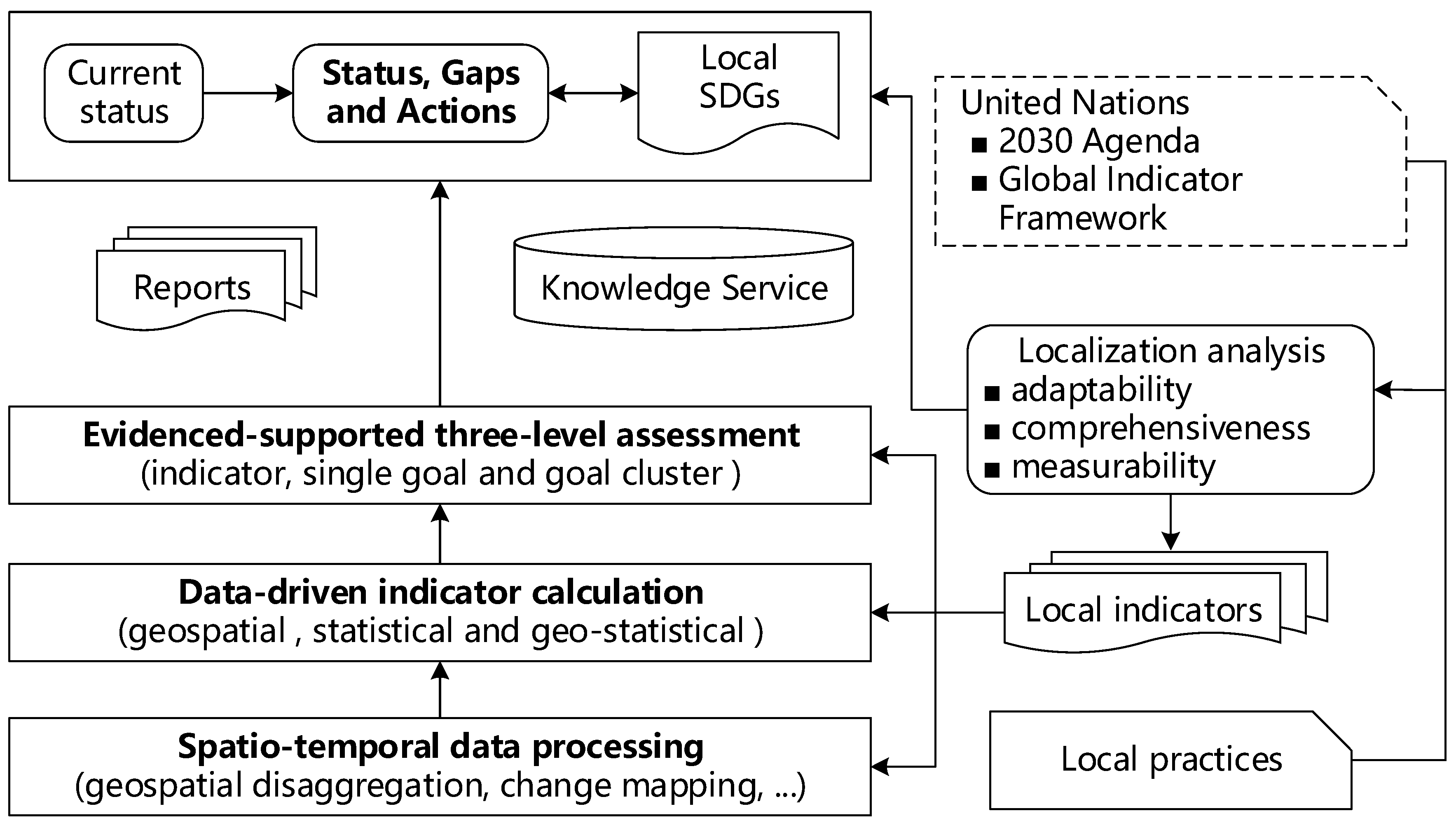
2. Methodology
- (1)
- SGIF-Aligned Indicator Adoption
- Adaptability: Referring to the analysis of whether each indicator of the Global Indicator Framework has a practical significance for the local context or adapts to the local development priorities;
- Comprehensiveness: Meaning that the selected indictors should cover the major aspects of local SDGs;
- Measurability: Used for determining whether each selected indicator can be quantified with reliable geospatial and statistical data.
- (2)
- Spatiotemporal Data Processing
- (3)
- Data-Driven Indicator Calculation
- (4)
- Evidence-Supported Progress Assessment
- (5)
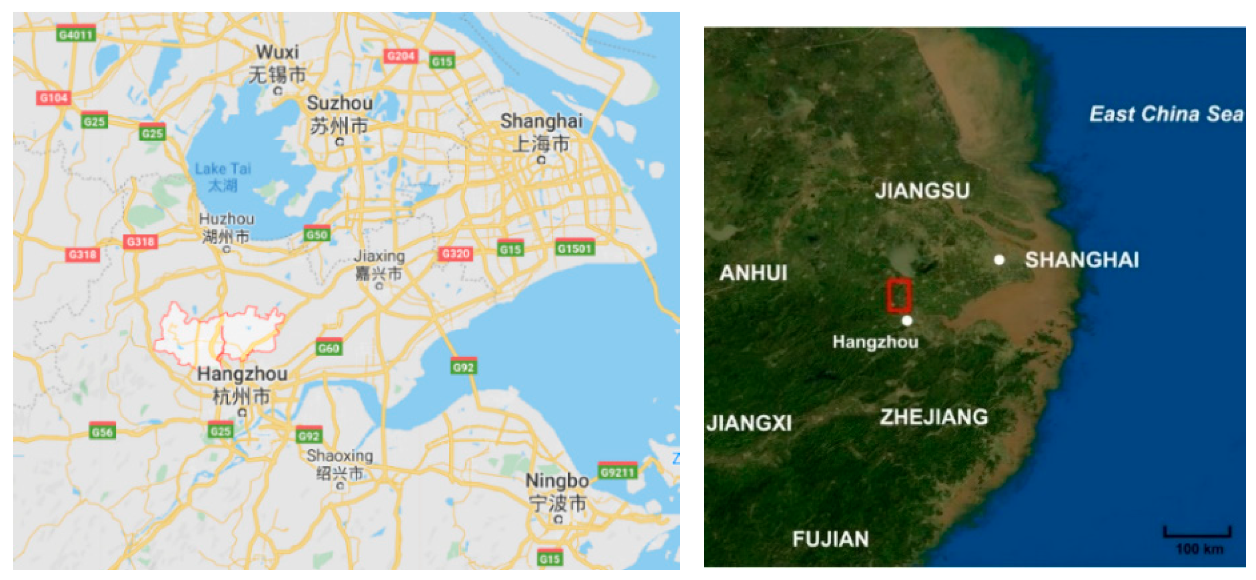
- Study Area
3. Comprehensive Measurement of SDGs with a Geographic Lens
3.1. Adoption of 102 Indicators with an AERS Strategy
- Adoption means that the original indicator, including metadata (the indicator name, definition, and calculation method), was not changed. An example is indicator “3.2.1: Under-five mortality rate”. The definition is same as the statistical yearbook [42] and the numerical values can be used directly. There were 47 indicators of this type (i.e., adoption).
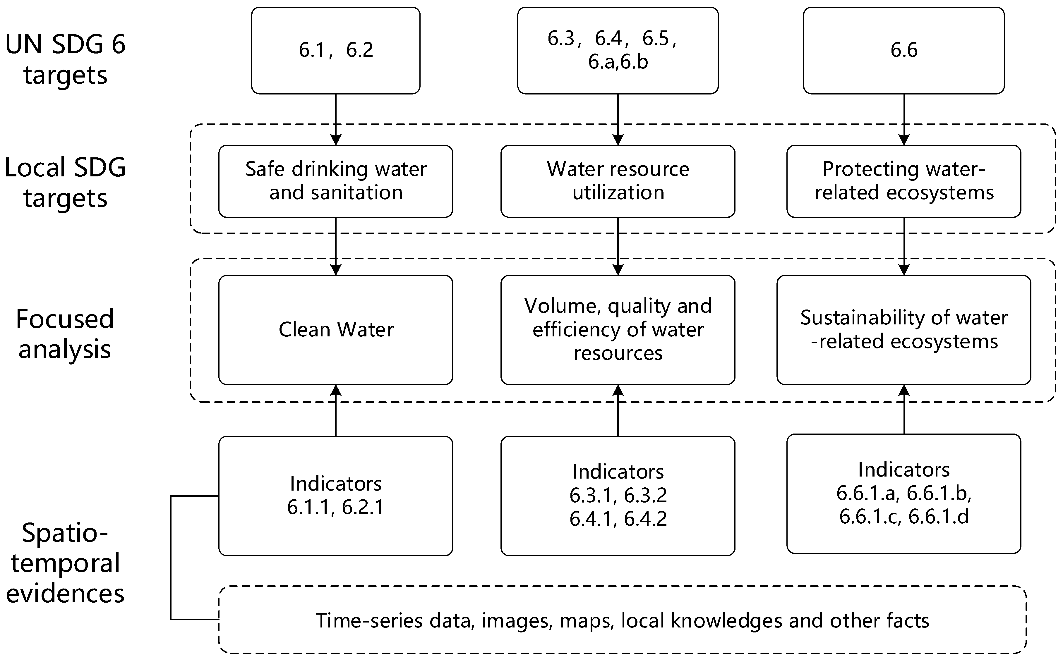
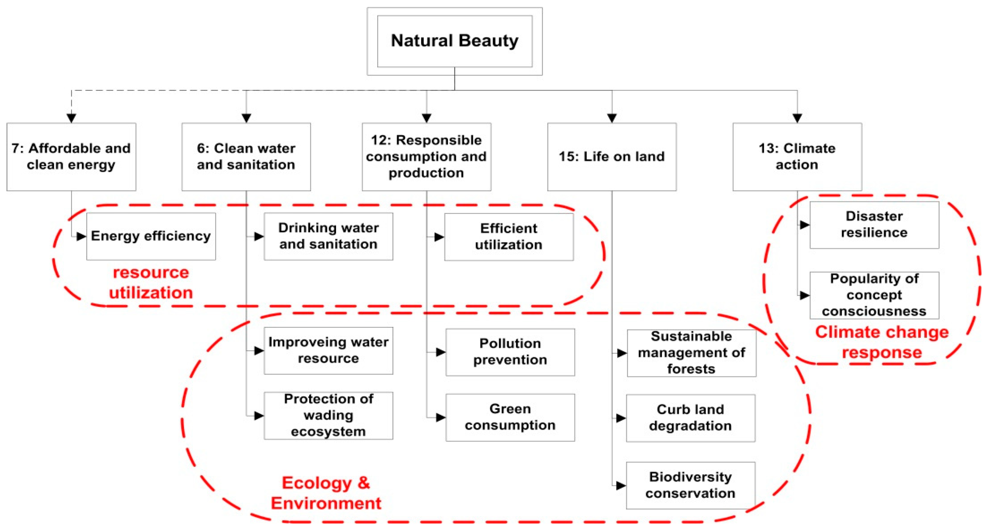
- Extension means that the name, definition, and calculation method of the original indicator were basically applicable, but the connotation or calculation method was extended somehow. There were six indicators in this category. An example is indicator “6.6.1: Change in the extent of water-related ecosystems over time”. Based on its definition, it was extended into four sub-indicators to quantitatively describe this indicator, i.e., (a) rate of change in the spatial extent of water-related ecosystems; (b) rate of change in the water quantity characteristic of water-related ecosystems; (c) rate of change in the water quality of water-related ecosystems; (d) health status of the typical wetland ecosystem.
- Revision was to modify the calculation method of the indicator in order to better satisfy the needs of local SDGs monitoring. Forty-two indicators were revised. An example is indicator “3.8.1 Coverage of essential health services”. The original definition contained multiple aspects which were too complicated for a county. Therefore, the definition was revised to how fast people can access health services with geospatial view.
- Substitution took place when the original indicator was not applicable. In this case, a new indicator was proposed. Seven indicators were substituted. An example is indicator “2.3.2: Per capita disposable income of rural residents”. The original indicator was the average income of small-scale food producers by sex and indigenous status with no metadata, which was substituted according to the local characteristics.
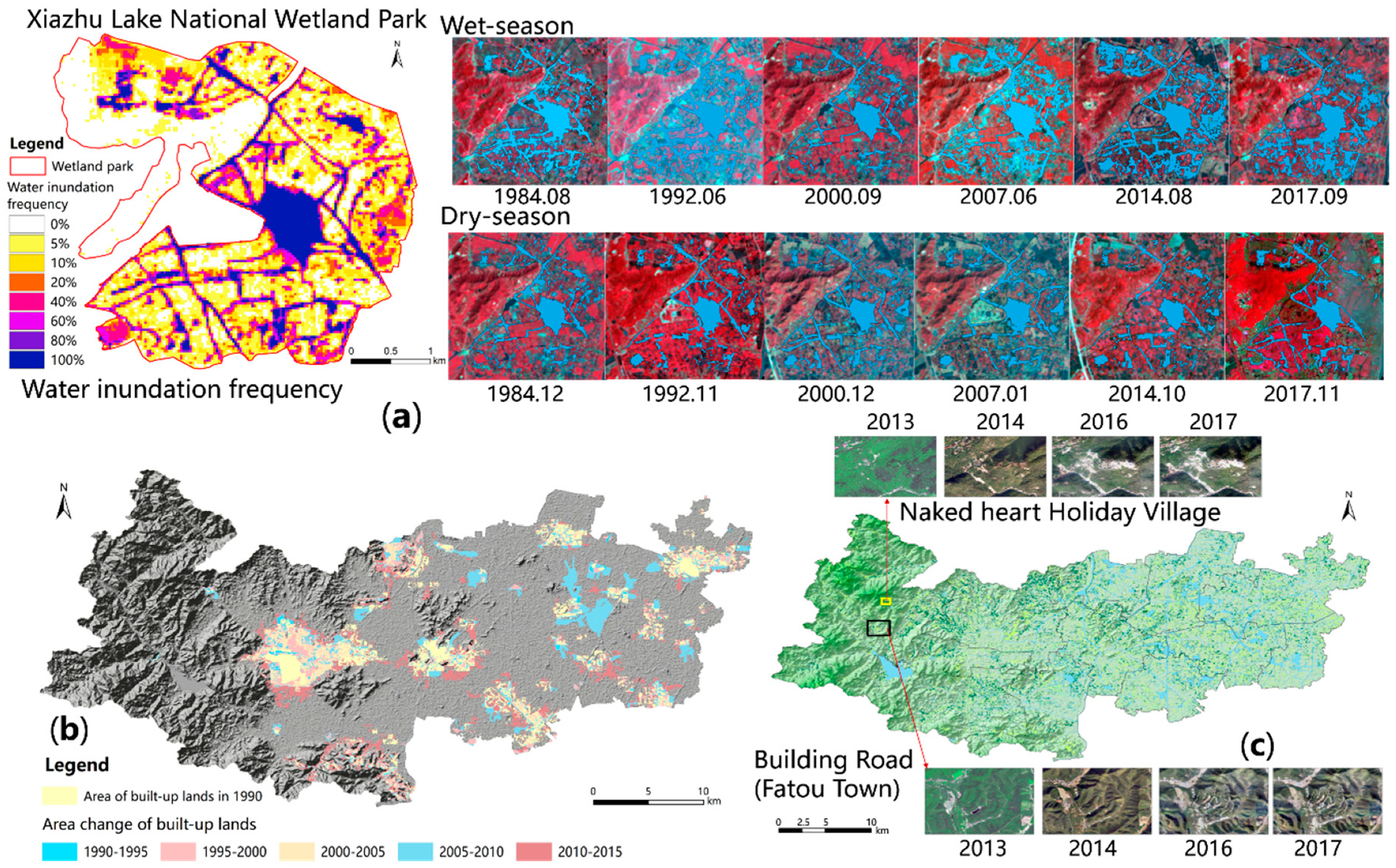
3.2. Geospatial Di-aggregation and Change Mapping
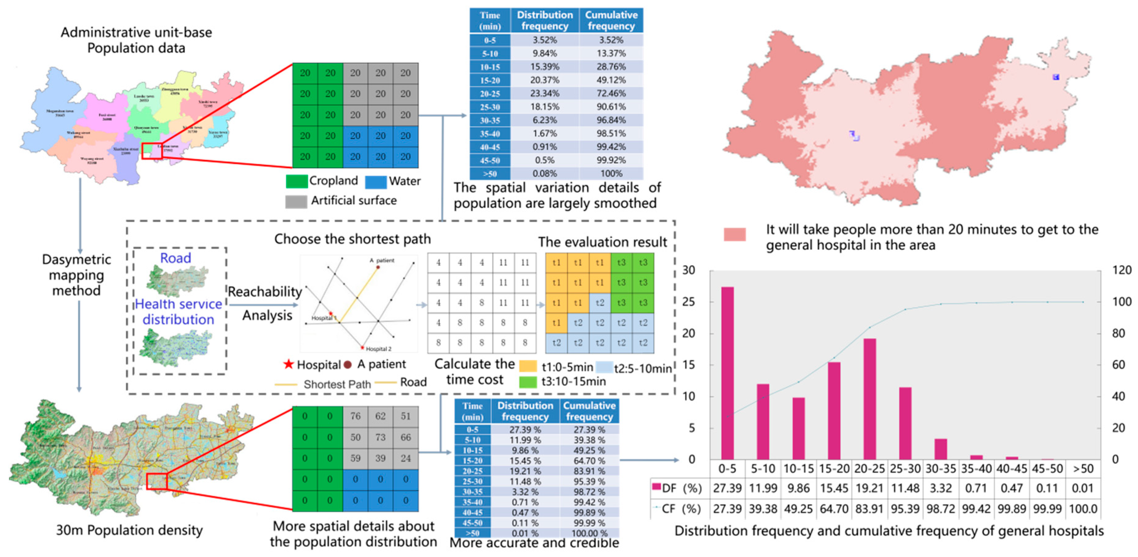
3.3. Measuring Local Indicators with a Geospatial Lens
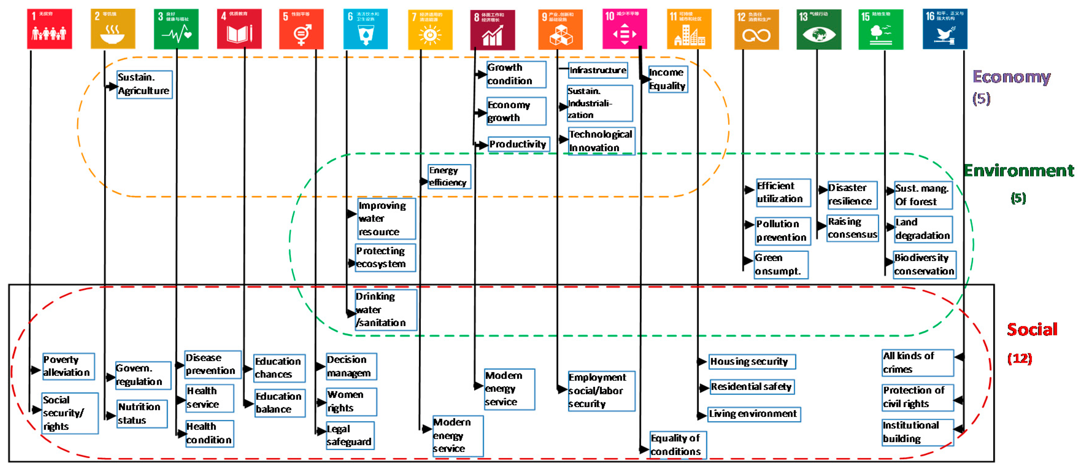
4. Comprehensive Assessment of SDG Indicators at Three Levels
4.1. Ranking of Indicators
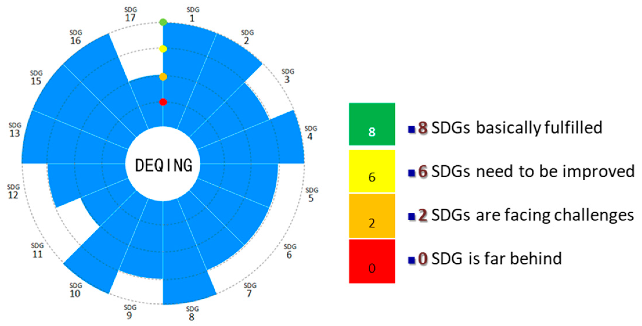
4.2. Evaluation of Individual Goals
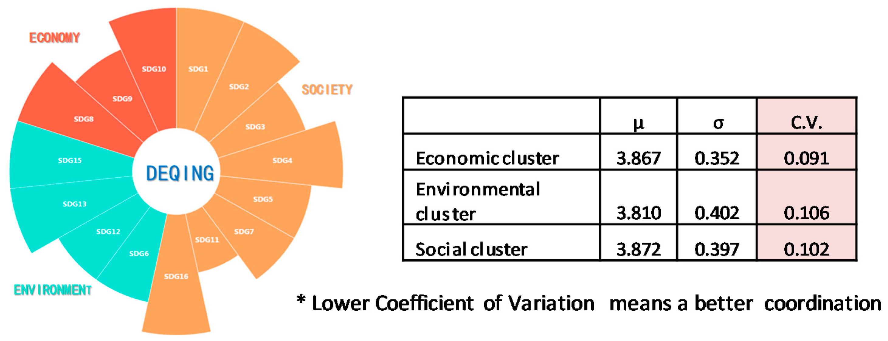
4.3. Evaluation of Goals in Three Clusters
4.4. Overall Assessment
5. Discussion: Lessons Learned and Experience Gained
5.1. Discussion: Lessons Learned and Experience Gained
5.2. Availability of Reliable Geospatial Information
5.3. Moving to Transformative Actions
5.4. Engagement of Stakeholders and Innovative Partnership
6. Conclusions
Author Contributions
Funding
Acknowledgments
Conflicts of Interest
References
- United Nations. Transforming Our World: The 2030 Agenda for Sustainable Development; A/RES/70/1; United Nations: New York, NY, USA, 2015. [Google Scholar]
- Schmidt-Traub, G.; De la Mothe Karoubi, E.; Espey, J. Indicators and a Monitoring Framework for the Sustainable Development Goals: Launching a Data Revolution for the SDGs; Sustainable Development Solutions Network: New York, NY, USA, 2015. [Google Scholar]
- Maurice, J. Measuring progress towards the SDGs—A new vital science. Lancet 2016, 388, 1455–1458. [Google Scholar] [CrossRef] [Green Version]
- UN-GGIM. The Integrated Geospatial Information Framework (IGIF). Available online: https://ggim.un.org/IGIF/ (accessed on 11 August 2020).
- UN IAEG-SDGs. Report of the Inter-Agency and Expert Group on Sustainable Development Goal Indicators; E/CN.3/2016/2/Rev.1; United Nations Economic and Social Council: New York, NY, USA, 2016. [Google Scholar]
- Persson, Å.; Weitz, N.; Nilsson, M. Follow-up and review of the Sustainable Development Goals: Alignment vs. internalization. Rev. Eur. Comp. Int. Environ. Law 2016, 25, 59–68. [Google Scholar] [CrossRef]
- Dizdaroglu, D. The role of indicator-based sustainability assessment in policy and the decision-making process: A review and outlook. Sustainability 2017, 9, 1018. [Google Scholar] [CrossRef] [Green Version]
- Scott, G.; Rajabifard, A. Sustainable development and geospatial information: A strategic framework for integrating a global policy agenda into national geospatial capabilities. Geo-Spat. Inf. Sci. 2017, 20, 59–76. [Google Scholar] [CrossRef] [Green Version]
- Liverman, D.M. Geographic perspectives on development goals: Constructive engagements and critical perspectives on the MDGs and the SDGs. Dialogues Hum. Geogr. 2018, 8, 168–185. [Google Scholar] [CrossRef] [Green Version]
- Schmidt-Traub, G.; Kroll, C.; Teksoz, K.; Durand-Delacre, D.; Sachs, J.D. National baselines for the Sustainable Development Goals assessed in the SDG Index and Dashboards. Nat. Geosci. 2017, 10, 547–555. [Google Scholar] [CrossRef]
- SDSN. Data, Indicators, and Follow-Up & Review [EB/OL]. Available online: http://unsdsn.org/what-we-do/data-indicators-follow-up-review/ (accessed on 6 February 2018).
- Allen, C.; Nejdawi, R.; El-Baba, J.; Hamati, K.; Metternicht, G.; Wiedmann, T. Indicator-based assessments of progress towards the sustainable development goals (SDGs): A case study from the Arab region. Sustain. Sci. 2017, 12, 975–989. [Google Scholar] [CrossRef]
- Nhemachena, C.; Matchaya, G.; Nhemachena, C.R.; Karuaihe, S.; Muchara, B.; Nhlengethwa, S. Measuring baseline agriculture-related sustainable development goals index for southern Africa. Sustainability 2018, 10, 849. [Google Scholar] [CrossRef] [Green Version]
- Allen, C.; Reid, M.; Thwaites, J.; Glover, R.; Kestin, T. Assessing national progress and priorities for the Sustainable Development Goals (SDGs): Experience from Australia. Sustain. Sci. 2020, 15, 521–538. [Google Scholar] [CrossRef]
- Xu, Z.; Chau, S.N.; Chen, X.; Zhang, J.; Li, Y.; Dietz, T.; Wang, J.; Winkler, J.A.; Fan, F.; Huang, B. Assessing progress towards sustainable development over space and time. Nature 2020, 577, 74–78. [Google Scholar] [CrossRef]
- Nagy, J.A.; Benedek, J.; Ivan, K. Measuring sustainable development goals at a local level: A case of a metropolitan area in Romania. Sustainability 2018, 10, 3962. [Google Scholar] [CrossRef] [Green Version]
- Estoque, R.C. A Review of the Sustainability Concept and the State of SDG Monitoring Using Remote Sensing. Remote Sens. 2020, 12, 1770. [Google Scholar] [CrossRef]
- Stokes, E.C.; Seto, K.C. Characterizing urban infrastructural transitions for the Sustainable Development Goals using multi-temporal land, population, and nighttime light data. Remote Sens. Environ. 2019, 234, 111430–111441. [Google Scholar] [CrossRef]
- Ishtiaque, A.; Masrur, A.; Rabby, Y.W.; Jerin, T.; Dewan, A. Remote Sensing-Based Research for Monitoring Progress towards SDG 15 in Bangladesh: A Review. Remote Sens. 2020, 12, 691. [Google Scholar] [CrossRef] [Green Version]
- Geng, W.; Chen, J.; Zhang, H.; Xu, K. Task and progress of IAEG-SDGS: WGGI in monitoring SDGs through a’geographic location’lens. Int. Arch. Photogramm. Remote Sens. Spat. Inf. Sci. 2018, 42, 385–390. [Google Scholar] [CrossRef] [Green Version]
- UNGGIM. Inter-Agency and Expert Group on the Sustainable Development Goal Indicators (IAEG-SDGS) Working Group on Geospatial Information. Available online: http://ggim.un.org/UNGGIM-wg6/ (accessed on 11 August 2020).
- UN-GGIM. The Global Statistical Geospatial Framework. Available online: http://ggim.un.org/meetings/GGIM-committee/9th-Session/documents/The_GSGF.pdf (accessed on 11 August 2020).
- Anderson, K.; Ryan, B.; Sonntag, W.; Kavvada, A.; Friedl, L. Earth observation in service of the 2030 Agenda for Sustainable Development. Geo-Spat. Inf. Sci. 2017, 20, 77–96. [Google Scholar] [CrossRef]
- Chinese Academy of Sciences. Earth Big Data Supporting Sustainable Development Goals. Available online: http://www.aircas.cas.cn/dtxw/rdxw/201909/t20190927_5402026.html (accessed on 31 September 2019).
- Andries, A.; Morse, S.; Murphy, R.; Lynch, J.; Woolliams, E.; Fonweban, J. Translation of Earth observation data into sustainable development indicators: An analytical framework. Sustain. Dev. 2019, 27, 366–376. [Google Scholar] [CrossRef] [Green Version]
- Andries, A.; Morse, S.; Murphy, R.J.; Lynch, J.; Woolliams, E.R. Seeing sustainability from space: Using Earth observation data to populate the UN Sustainable Development Goal indicators. Sustainability 2019, 11, 5062. [Google Scholar] [CrossRef] [Green Version]
- Masó, J.; Serral, I.; Domingo-Marimon, C.; Zabala, A. Earth observations for sustainable development goals monitoring based on essential variables and driver-pressure-state-impact-response indicators. Int. J. Digit. Earth 2020, 13, 217–235. [Google Scholar] [CrossRef] [Green Version]
- Kuffer, M.; Wang, J.; Nagenborg, M.; Pfeffer, K.; Kohli, D.; Sliuzas, R.; Persello, C. The scope of earth-observation to improve the consistency of the SDG slum indicator. ISPRS Int. J. of Geo-Inf. 2018, 7, 428. [Google Scholar] [CrossRef] [Green Version]
- Xiao, W.; Mills, J.; Guidi, G.; Rodríguez-Gonzálvez, P.; Barsanti, S.G.; González-Aguilera, D. Geoinformatics for the conservation and promotion of cultural heritage in support of the UN Sustainable Development Goals. ISPRS J. Photogramm. Remote Sens. 2018, 142, 389–406. [Google Scholar] [CrossRef]
- Choi, J.; Hwang, M.; Kim, G.; Seong, J.; Ahn, J. Supporting the measurement of the United Nations’ sustainable development goal 11 through the use of national urban information systems and open geospatial technologies: A case study of south Korea. Open Geospat. Data Softw. Stand. 2016, 1, 4–13. [Google Scholar] [CrossRef] [Green Version]
- Boyd, D.S.; Jackson, B.; Wardlaw, J.; Foody, G.M.; Marsh, S.; Bales, K. Slavery from space: Demonstrating the role for satellite remote sensing to inform evidence-based action related to UN SDG number 8. ISPRS J. Photogramm. Remote Sens. 2018, 142, 380–388. [Google Scholar] [CrossRef]
- Whitcraft, A.K.; Becker-Reshef, I.; Justice, C.O.; Gifford, L.; Kavvada, A.; Jarvis, I. No pixel left behind: Toward integrating Earth Observations for agriculture into the United Nations Sustainable Development Goals framework. Remote Sens. Environ. 2019, 235, 111470–111484. [Google Scholar] [CrossRef]
- Kussul, N.; Lavreniuk, M.; Kolotii, A.; Skakun, S.; Rakoid, O.; Shumilo, L. A workflow for sustainable development goals indicators assessment based on high-resolution satellite data. Int. J. Digit. Earth 2019, 13, 309–321. [Google Scholar] [CrossRef]
- Nilsson, M.; Griggs, D.; Visbeck, M. Policy: Map the interactions between Sustainable Development Goals. Nature 2016, 534, 320–322. [Google Scholar] [CrossRef]
- Lu, Y.; Wang, Y.; Yuan, J.; He, G. Some thoughts on promoting the implementation of sustainable development goals in China. China Popul. Resour. Environ. 2018, 28, 1–9. [Google Scholar]
- Chen, J.; Ren, H.; Geng, W.; Peng, S.; Ye, F. Quantitative measurement and monitoring sustainable development goals (SDGs) with geospatial information. Geomat. World 2018, 25, 1–7. [Google Scholar]
- Chen, J.; Li, Z. China tracks its progress on SDGs. Nature 2018, 563, 184. [Google Scholar] [CrossRef] [Green Version]
- Chen, J.; Peng, S.; Zhao, X.S.; Ge, Y.J.; Li, Z.L. Measuring regional progress towards SDGs by combining geospatial and statistical information. Acta Geod. Cartogr. Sin. 2019, 48, 473–479. [Google Scholar]
- Qiu, Y.; Zhao, X.; Fan, D.; Li, S. Geospatial disaggregation of population data in supporting SDG assessments: A case study from Deqing County, China. ISPRS Int. J. Geo-Inf. 2019, 8, 356. [Google Scholar] [CrossRef] [Green Version]
- Chen, J.; Zhang, J.; Zhang, W.W.; Peng, S. Continous Updating and Refinement of Land Cover Data Product. J. Remote Sens. 2016, 20, 991–1001. [Google Scholar]
- Liu, S.; Bai, J.; Chen, J. Measuring SDG 15 at the County Scale: Localization and Practice of SDGs Indicators Based on Geospatial Information. ISPRS Int. J. of Geo-Inf. 2019, 8, 515. [Google Scholar] [CrossRef] [Green Version]
- Deqing Government. Deqing Statistical Yearbook; China Statistical Publishing House: Beijing, China, 2017.
- Holt, J.B.; Lo, C.; Hodler, T.W. Dasymetric estimation of population density and areal interpolation of census data. Cartogr. Geogr. Inf. Sci. 2004, 31, 103–121. [Google Scholar] [CrossRef]
- Lu, N.; Zhang, W.; Chen, L.; Li, Z.; Chen, J.; Li, R.; Chen, X.; Zhang, Y.; Liu, J. Estimation of large regional urban and rural population density based on the differences of population distribution between urban and rural: Take Shandong Province as example. Acta Geod. Cartogr. Sin. 2015, 44, 1384–1391. [Google Scholar]
- Sachs, J.; Schmidt-Traub, G.; Kroll, C.; Durand-Delacre, D.; Teksoz, K. SDG Index and Dashboards Report 2017; Bertelsmann Stiftung and Sustainable Development Solutions Network (SDSN): New York, NY, USA, 2017; Available online: http://sdgindex.org/reports/2017/ (accessed on 16 February 2018).
- The State Council of the People’s Republic of China. China’s National Plan on Implementation of the 2030 Agenda for Sustainable Development; The State Council of the People’s Republic of China: Beijing, China, 2016. Available online: http://www.gov.cn/xinwen/2016-10/13/content_5118514.htm (accessed on 31 August 2020).
- United Nations. Step-by-Step Methodology for Monitoring Ecosystems (6.6.1). Available online: https://www.unwater.org/publications/step-step-methodology-monitoring-ecosystems-6-6-1/ (accessed on 16 February 2018).
- Kleynhans, C.; Louw, M. River Ecoclassification: Manual for Ecostatus Determination (Version 2)—Module A: EcoClassification and EcoStatus Determination; Water Research Commission: Pretoria, South Africa, 2008.
- Everitt, B. The Cambridge Dictionary of Statistics; Cambridge University Press: Cambridge, UK, 1998. [Google Scholar]
- Kanter, D.R.; Schwoob, M.-H.; Baethgen, W.E.; Bervejillo, J.E.; Carriquiry, M.; Dobermann, A.; Ferraro, B.; Lanfranco, B.; Mondelli, M.; Penengo, C. Translating the sustainable development goals into action: A participatory backcasting approach for developing national agricultural transformation pathways. Glob. Food Secur. 2016, 10, 71–79. [Google Scholar] [CrossRef]


| SDG | Num. of SGIF Indicators | Num. of Deqing Indicators | Indicators |
|---|---|---|---|
| 1 | 14 | 5 | 1.1.1; 1.3.1; 1.4.1; 1.a.2; 1. b.1 |
| 2 | 13 | 9 | 2.1.1; 2.1.2; 2.2.1;2.2.2; 2.3.1; 2.3.2; 2.4.1; 2.a.1; 2.c.1 |
| 3 | 27 | 15 | 3.1.1; 3.1.2; 3.2.1; 3.2.2; 3.3.1; 3.3.2; 3.3.3; 3.3.4; 3.4.1; 3.6.1; 3.7.1; 3.8.1; 3.b.1; 3.b.2; 3.c.1 |
| 4 | 11 | 7 | 4.1.1; 4.2.2; 4.3.1; 4.5.1; 4.6.1; 4.a.1; 4.c.1 |
| 5 | 14 | 4 | 5.1.1; 5.5.1; 5.5.2; 5.c.1 |
| 6 | 11 | 7 | 6.1.1; 6.2.1; 6.3.1; 6.3.2; 6.4.1; 6.4.2; 6.6.1 |
| 7 | 6 | 3 | 7.1.1; 7.1.2; 7.3.1 |
| 8 | 17 | 6 | 8.1.1; 8.2.1; 8.5.2; 8.6.1; 8.9.1; 8.9.2 |
| 9 | 12 | 9 | 9.1.1; 9.1.2; 9.2.1; 9.2.2; 9.3.1; 9.5.1; 9.5.2; 9.b.1; 9.c.1 |
| 10 | 11 | 2 | 10.1.1; 10.2.1 |
| 11 | 15 | 9 | 11.1.1; 11.2.1; 11.3.1; 11.4.1; 11.5.1; 11.5.2; 11.6.1; 11.6.2; 11.7.1; |
| 12 | 13 | 5 | 12.2.2; 12.4.2; 12.5.1; 12.6.1; 12.7.1 |
| 13 | 8 | 4 | 13.1.1; 13.1.3; 13.3.1; 13.3.2 |
| 15 | 14 | 7 | 15.1.1; 15.1.2; 15.2.1; 15.3.1; 15.4.1; 15.4.2; 15.a.1 |
| 16 | 23 | 5 | 16.1.1; 16.1.3; 16.3.2; 16.5.1; 16.6.1 |
| 17 | 25 | 5 | 17.1.1; 17.2.1; 17.3.1; 17.8.1; 17.11.1 |
| Total | 234 | 102 |
| No | Indicator | Type 1 | |
|---|---|---|---|
| 1 | 1.4.1 | Population and proportions living in households with access to basic services | A |
| 2 | 2.4.1 | Proportion of agricultural area under productive and sustainable agriculture | B |
| 3 | 3.8.1 | Coverage of essential health services | A |
| 4 | 6.2.1 | Proportion of population using safely managed sanitation services | A |
| 5 | 6.3.2 | Proportion of bodies of water with good ambient water quality | B |
| 6 | 6.6.1 | a Change in the extent of water-related ecosystems over time d Health status of the typical wetland ecosystem | A |
| 7 | 9.1.1 | a Proportion of rural population living within 2 km of an all-season road b Road density c Weighted average travel time | A |
| 8 | 11.2.1 | Proportion of population that has convenient access to public transport, by sex, age and persons with disabilities | A |
| 9 | 11.3.1 | Ratio of land consumption rate to population growth rate | A |
| 10 | 11.7.1 | Average share of the built-up area of cities that is open space for public use for all, by sex, age, and persons with disabilities | B |
| 11 | 15.1.1 | Forest area as a proportion of total land area | B |
| 12 | 15.1.2 | Proportion of important sites for terrestrial and freshwater biodiversity covered by protected areas, by ecosystem type | B |
| 13 | 15.2.1 | Proportion of forest change | B |
| 14 | 15.3.1 | Proportion of land that is degraded over total land area | B |
| 15 | 15.4.1 | Protected area coverage of import. sites for mountain biodiversity | B |
| 16 | 15.4.2 | Mountain vegetation cover | B |
| Indicators | Quantitative Result | Evaluation Reference | |
|---|---|---|---|
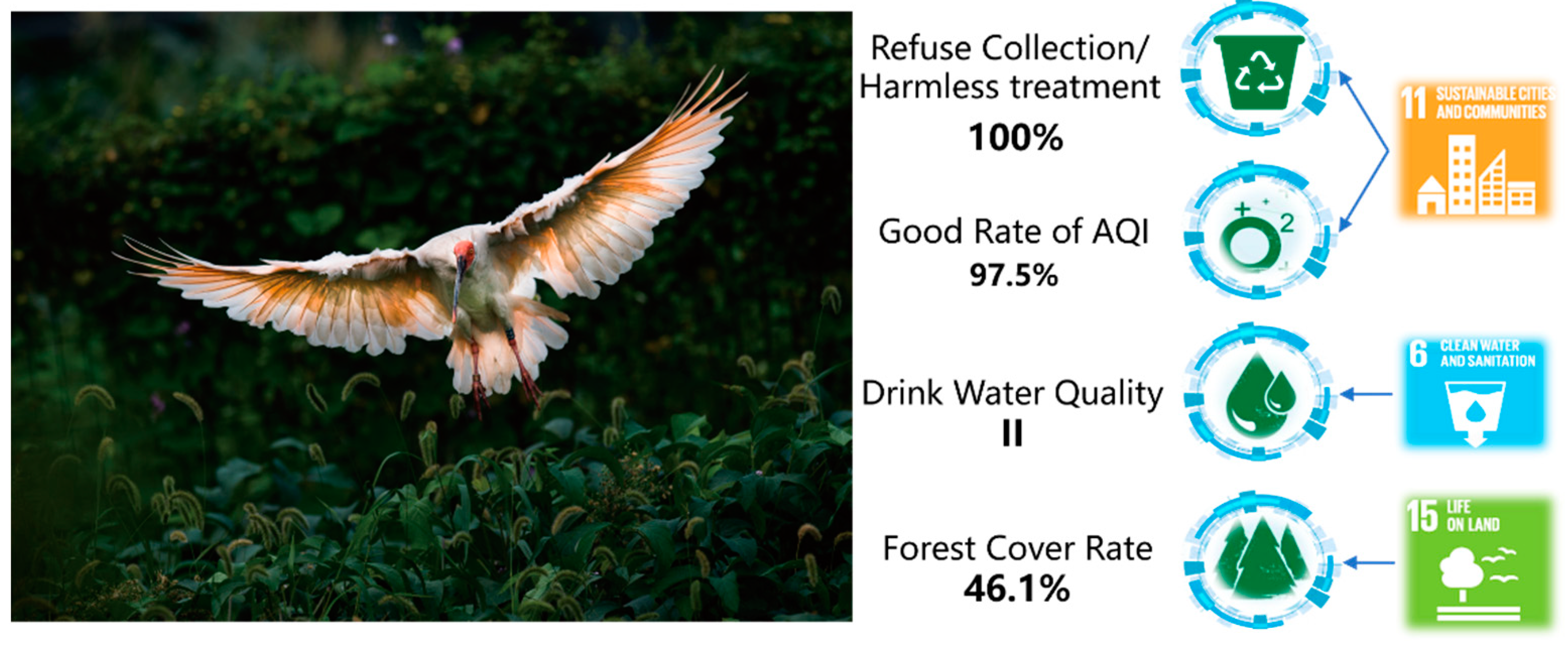
| 6.1.1 Proportion of population using safely managed drinking water services | Urban: 100% Rural: 99.6% | Green: ≥98% | I |
| 6.2.1.a Penetration rate of sanitary toilets in rural areas | 98% | Green: ≥95% | I |
| 6.2.1.b Service convenience of urban public toilets | From all parts of town, the nearest public toilet can be reached within 16 min | ||
| 6.3.1 Proportion of wastewater safely treated | Urban domestic sewage: 91.06% | Municipal domestic sewage: 92.4%; | IV |
| Rural domestic sewage: 80.68% | Coverage rate of the treatment of domestic wastewater (upper-middle-income countries):59% | III | |
| Trade effluent: N/A | |||
| 6.3.2 Proportion of bodies of water with good ambient water quality | 68.75%, 100% ** | 76.9% | IV |
| 6.4.1 Change in water-use efficiency over time | The water consumption per 10,000 CNY of GDP in 2017 was 65.7 m3, dropped 23.52% from 2015 | By 2020, the efficiency of water use will be 23% lower than that of 2015 | II |
| 6.4.2 Level of water stress: freshwater withdrawal as a proportion of available freshwater resources | 25.08% | Green: ≤25% Yellow: 25% < x ≤ 50% | I |
| 6.6.1 Change in the extent of water-related ecosystems over time | 6.47% | 0–20%: Highly sustainable; 21–40%: Locally sustainable but threatens global stability; 41–60%: Border-line sustainability. Corrective actions are strongly recommended; 61–100%: Unsustainable Urgent renewal is required. | III |
| 6.6.1.a Rate of change in the spatial extent of water-related ecosystems | 11.14% | ||
| 6.6.1.b Rate of change in the water quantity characteristic of water-related ecosystems | 8.26% | ||
| 6.6.1.c Rate of change in the water quality of water-related ecosystems | 0% | ||
| 6.6.1.d Health status of the typical wetland ecosystem | Xiazhu Lake wetland: In good condition | ||
 1st Quarter
  2nd Quarter
  No ranking.
© 2020 by the authors. Licensee MDPI, Basel, Switzerland. This article is an open access article distributed under the terms and conditions of the Creative Commons Attribution (CC BY) license (http://creativecommons.org/licenses/by/4.0/).
Share and Cite
Chen, J.; Peng, S.; Chen, H.; Zhao, X.; Ge, Y.; Li, Z. A Comprehensive Measurement of Progress toward Local SDGs with Geospatial Information: Methodology and Lessons Learned. ISPRS Int. J. Geo-Inf. 2020, 9, 522. https://doi.org/10.3390/ijgi9090522
Chen J, Peng S, Chen H, Zhao X, Ge Y, Li Z. A Comprehensive Measurement of Progress toward Local SDGs with Geospatial Information: Methodology and Lessons Learned. ISPRS International Journal of Geo-Information. 2020; 9(9):522. https://doi.org/10.3390/ijgi9090522
Chicago/Turabian StyleChen, Jun, Shu Peng, Hao Chen, Xuesheng Zhao, Yuejing Ge, and Zhilin Li. 2020. "A Comprehensive Measurement of Progress toward Local SDGs with Geospatial Information: Methodology and Lessons Learned" ISPRS International Journal of Geo-Information 9, no. 9: 522. https://doi.org/10.3390/ijgi9090522