1. Introduction
Urbanization is a spatial process. As a result of urbanization, the change of urban spatial form clearly reflects the process of urbanization. The evolution of urban spatial morphology has always been a hot topic in urban geography. A bay city is a special kind of city type, characterized by three characteristics: highly developed, greatly affected by the ocean, and greatly affected by the type of the bay. First, located at the interface between the sea and the land, bays are a high-value, highly developed and highly fragile ecosystem. Since ancient times, bays have been the gateway to overseas transportation and have acted as industrial centers, playing an extremely important strategic role in economic and social development [
1,
2]. Many of the world’s famous ports, such as the Port of Los Angeles, Shenzhen Port and Bangkok Port, have developed in bays. Second, throughout the history of coastal cities [
3], the development of coastal cities often depends on the marine economy. The siting and development of urban centers are influenced by the distance from the ocean and coastal geography. Finally, influenced by the formation of the bay, the types of the bay are various, and the topographical morphology varies greatly. It will affect city orientation and city form. Nowadays, as the population continues to converge to the coastal zone, the demand and scale of construction land in bays is expanding, and the built-up area is expanding rapidly. Quantitative analyses of the development intensity and changing characteristics of construction land in bays are of great significance for urban development, urban planning and ecological, environmental protection in bay areas [
4].
Scholars worldwide have conducted much research on the evolution of urban spatial morphology. The urban spatial form is the visual appearance of urban space expansion [
5]. The essence of urban space expansion is the renewal and combination of urban land, which is mainly manifested in the sprawl of outer space boundary and the reorganization of inner space structures [
6]. The current research on urban landform was conducted in two ways, including empirical analysis and quantitative measure. On one hand, empirical analysis relies on theoretical analysis (urban morphology) or basic data statistics to elucidate the process of urban expansion and its characteristics. The research on urban morphology originated in the 19th century. The classical urban spatial structure includes the concentric ring model (proposed by E.W. Burgess), sector model (proposed by H. Hoyt) and multi-core model (proposed by C.D. Harris) [
7]. Nowadays, the typical urban forms can be divided into block, strip, radial, constellation, group and checkerboard patterns [
8,
9]. The modes of urban land expansion include the compact mode and the loose mode, and the common spatial expansion patterns can be divided into axial, concentric circle, corridor, fan-shaped, filling and spreading growth as well as satellite cities [
10,
11,
12,
13,
14]. The measurement of urban form is mostly interpreted in a qualitative way. Quantitative identification of urban spatial extension types has also been carried out in recent years. Liu used the convex hull principle to identify two types of urban land expansion, including filling type and extension type [
15]. Moreover, some simple data statistics were also used in the analysis of urban expansion form. For example, the European research territorial projects Otremed and OSDDT (Occupation des sols et development durable sur l’arc mediterranéen) have developed important territorial tools important with a number of variables for analysis and advanced diagnostics in urban planning [
16].
On the other hand, quantitative measure relies on designing the indexes to measure the geometrical morphology and spatial relation of urban land. Common measurement methods include mathematical, statistical methods, fractal dimensions and landscape index methods. Mathematical statistics methods describe the geometric features, size, density and distribution of a city by calculating its shape, circumference, area and distance. Common mathematical indexes include circularity ratio, compactness, shape index and radial shape index etc. [
17,
18,
19]. The application of fractal theory to urban expansion began in the 1980s. Batty M et al. [
20] proposed the boundary fractal characteristics of urban morphology and the calculation method of boundary fractals. In the evolutionary process of urban formation, the fractal dimension of the boundary of urban construction land reflects the compactness and change mode of the urban external form [
21]. Guo [
22] extracted the built-up areas of 29 major cities in China from 2000 to 2013 and measured the expansion speed, compactness, fractal dimension and shape index of each city. The results showed that the fractal dimension indexes of the cities and the fragmentation of urban space increased. Landscape pattern is the spatial arrangement and combination of landscape spatial units with different sizes, shapes and properties. The landscape pattern method introduces landscape indexes to analyze the spatial pattern and characteristics of urban land use and expansion by using the theoretical method of landscape ecology. In general, landscape pattern index can be described on three levels: patch level, class level and landscape level. Over the past decades, there has been a proliferation of statistical measures of landscape indices, including patch density, largest patch index, landscape shape index, fractal dimension index, contiguity index, aggregation index, landscape diversity index, landscape heterogeneity index and landscape homogeneity index, etc. [
17,
23,
24]. Based on landscape indexes, Liu et al. [
25] proposed the landscape expansion index (LEI), which can be used to analyze dynamic changes in two or more temporal landscape patterns and applied them to Dongguan City. The results showed that LEIs could identify the types of urban expansion, i.e., filling type, edge type and enclave type. Jiao et al. [
26] proposed an improved spatial metric, multi-order landscape expansion index (MLEI), to measure the expansion degree of newly grown urban patches by considering their relationships with old patches and their spatial context in the process of urban expansion.
The land-sea gradient and elevation differentiation are two of the most basic spatial pattern characteristics of many geographical elements [
27]. As the distance from the sea increased, the physiographic features, biogenic features, and physiochemical features shows a tendency of gradient [
28]. Accordingly, the land-use patterns vary in the sea–land direction. Strip division was a common method, and it involves parallel divisions moving the coastline inland with consistent spacing. Hou et al. [
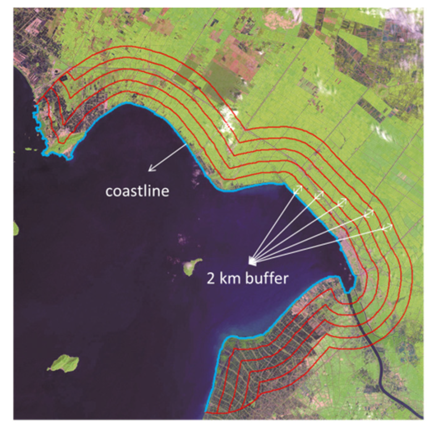
27] conducted strip segmentation at an interval of 2 km perpendicular to the coastal zone and chose 15 strips on the landward side as the research areas to analyze the land structure characteristics and differentiation characteristics of different strips. The results showed that the 4–6 km strip had a peak value of the comprehensive land use index, which was followed by the 2–4 km strip and 8–10 km strip. Ding et al. [
29,
30] developed a model, called sequence-based clustering of coastal land use pattern (SCCLUP), to mine the coastal land use sequence patterns (CLUSPs) along the sea–land direction. The research in the major coastal zone of Bohai Bay and the Yellow River Delta showed that the artificial level of CLUSPs was continuously increasing, and new CLUSPs tended to distribute around port areas. To a certain extent, topography has shaped the distribution pattern of land use [
31]. Especially in the coastal areas, the geomorphologic differences in different regions are rather significant. Zhang et al. [
32] divided the coastal zone surrounding the South China Sea into 51 zones according to the coastal landform and discussed the spatiotemporal characteristics of construction land expansion based on different geomorphologic backgrounds. The results showed that in areas where there were good conditions for water transport and wide hinterlands, construction land on the delta plain coast and estuary plain coast expanded rapidly.
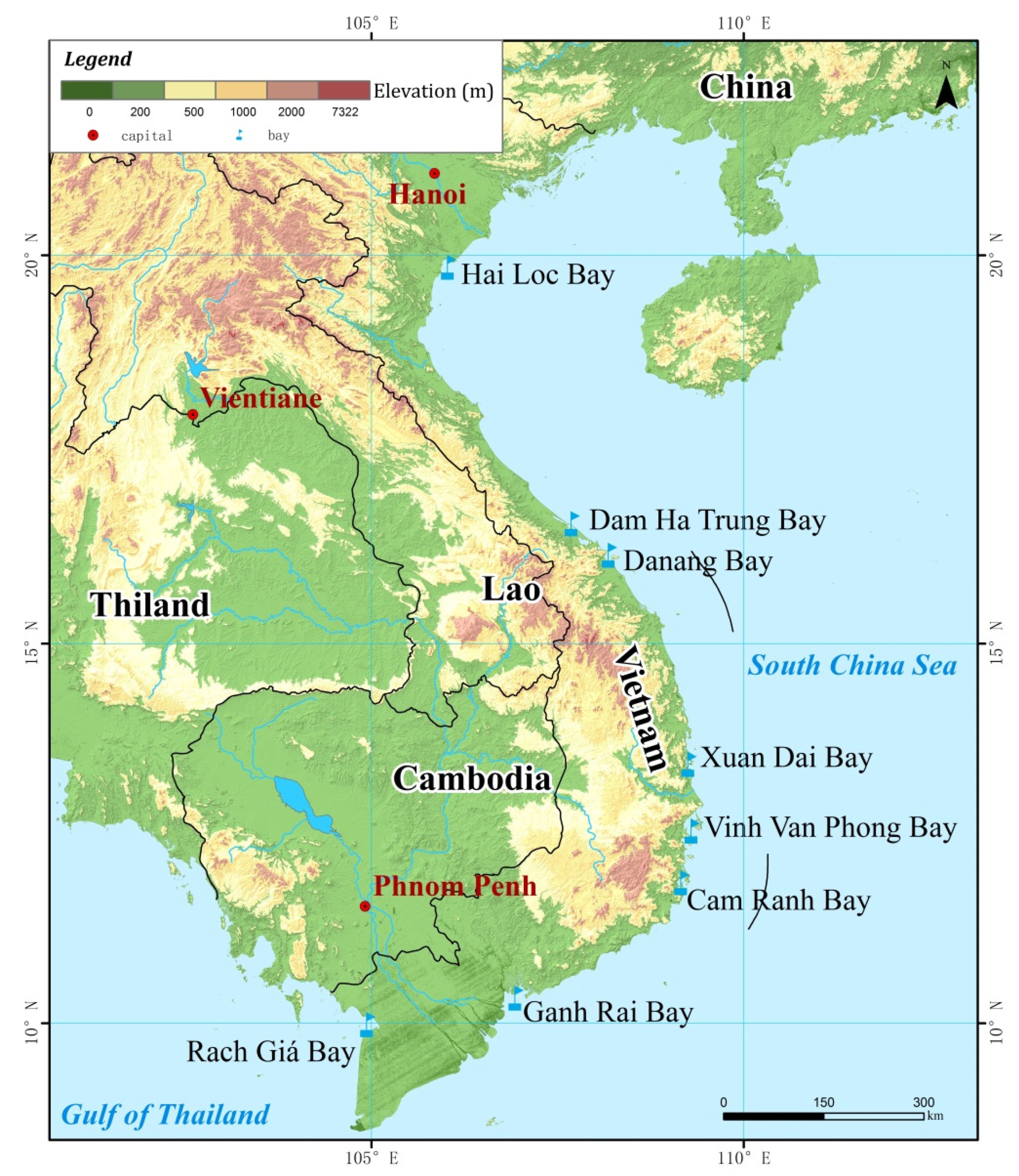
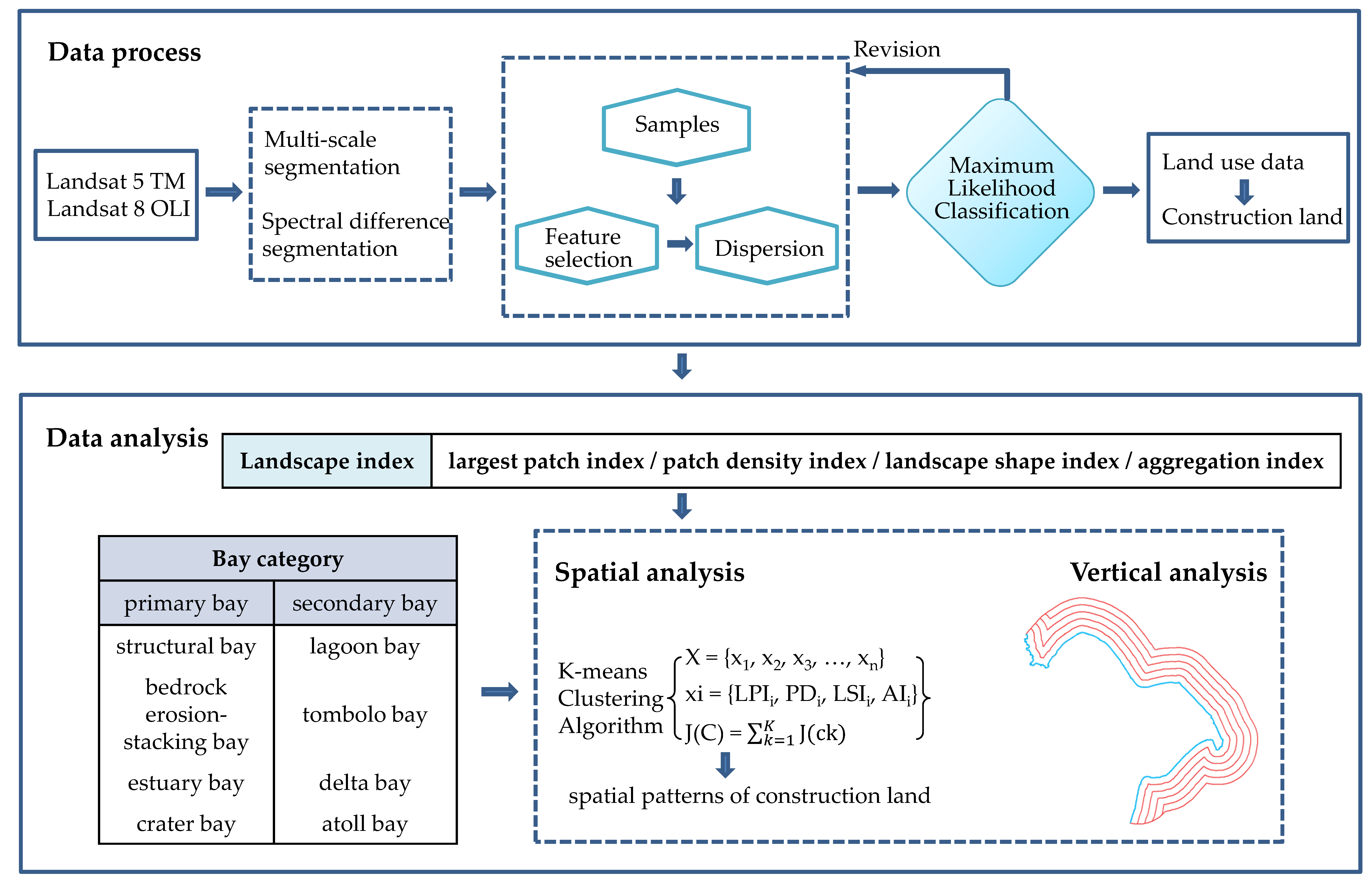
According to the results of a literature search, the typical urban forms come from empirical exploration. Studies are deficient in the quantification of the spatial pattern of construction land without prior knowledge. Furthermore, current studies of urban spatial morphology rarely focused on the particularity of coastal cities, such as sea–land gradient features and bay types. In this paper, we provided a method to analyze the spatial pattern of construction land in the bay area. It included two parts: spatial analysis and vertical analysis. Landscape indexes and a clustering algorithm were used to identify the spatial pattern of construction land distribution. Strip division was used to analyze the landscape features of construction land in the sea–land direction. The bay type is defined according to the factors underlying the bay formation and is used to analyze the influence on the spatial and vertical distribution of construction land. In order to exclude the influence of different national policies as well as taking into account the richness of bay types, we chose eight bays along the coast of Vietnam as the research areas.
3. Results
3.1. Regional Trends
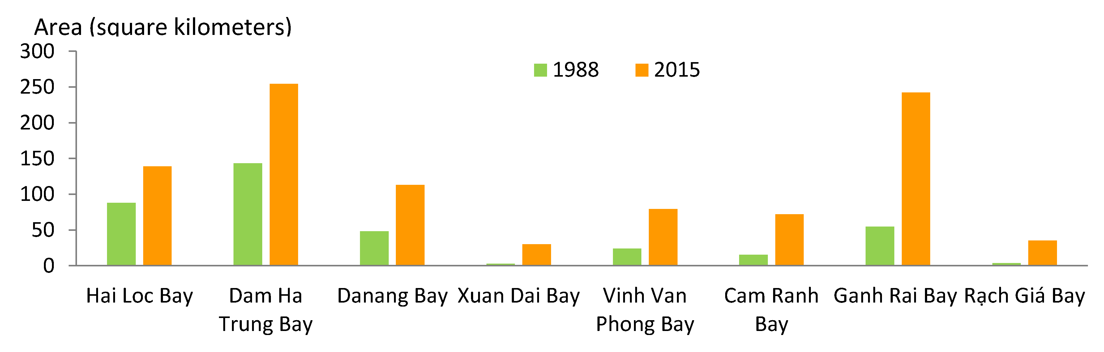
Table 7 and
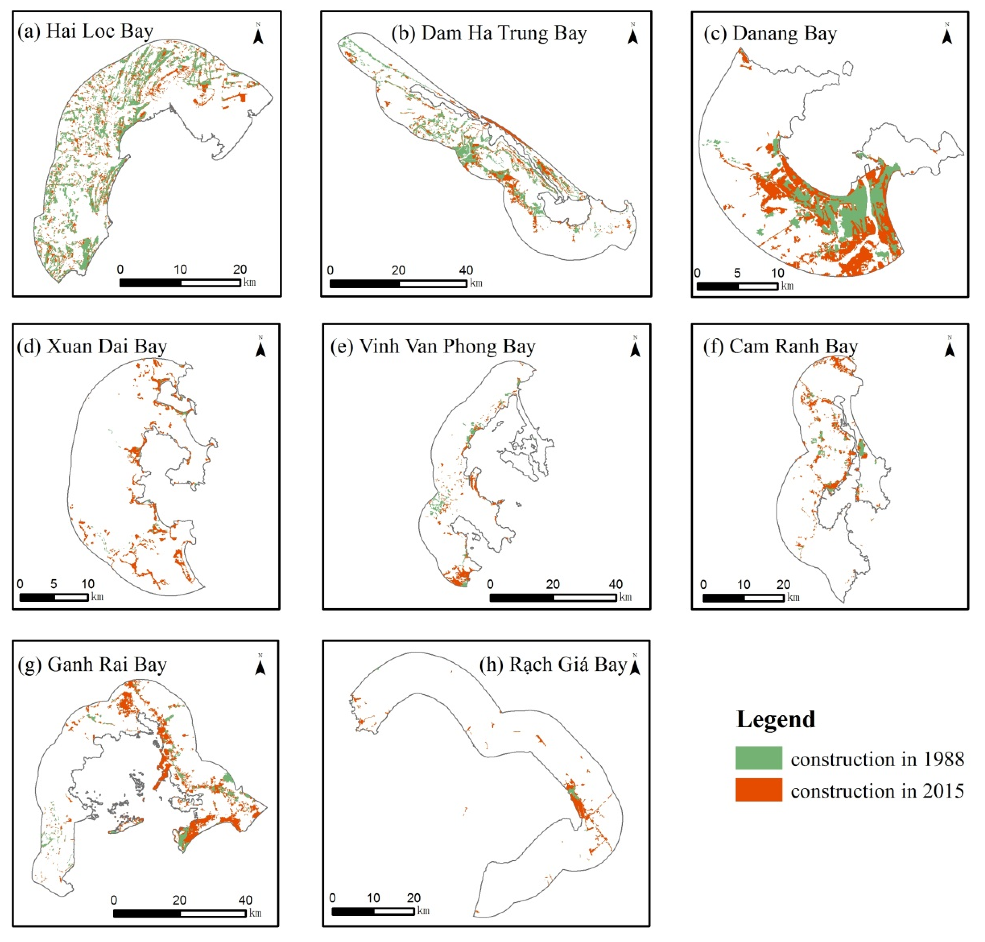
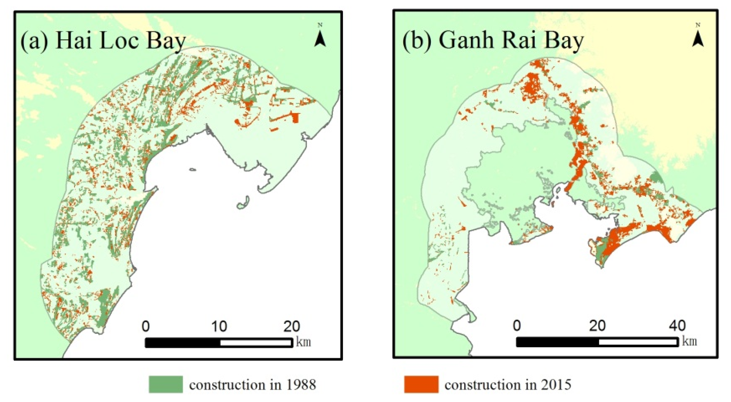
Figure 4 show the proportions and areas of construction land in each bay. The spatial distributions of construction land in bays for 1988 and 2015 are shown in
Figure 5. Across the region, the total proportion was 4.9% in 1988. The built-up area significantly expanded during the following 30 years. In 2015, the proportion more than doubled, with increases of up to 12.5%. The average annual growth rate was 0.25%.
Among the bays, the proportions of construction land in Hai Loc Bay, Dam Ha Trung Bay and Danang Bay were more than 10% in 1988. These three bays are distributed along the northern coast of Vietnam. In contrast, construction land was distributed sparsely in the five southern bays. The proportions were lower than 5%, especially in Xuan Dai Bay and Rach Giá Bay, where the proportions were lower than 1%. In addition to the above three bays, the proportion of construction land in Ganh Rai Bay climbed to 15.4% in 2015. However, these four bays presented growth that exceeded the average growth. The proportion of construction land was greatest (26.5%) in Danang Bay, followed by Hai Loc Bay (24.5%). The highest growth rate was also in Danang Bay (15.2%), which was twice the average growth (7.6%). It is worth mentioning that although the proportion of construction land in Ganh Rai Bay was not too high (3.5% in 1988 and 15.4% in 2015), the growth rate was drastic (11.9%). The net increase of built-up area in Banh Rai Bay was also the largest, up to 187.4 square kilometers. In addition, the net increase of built-up area in Dam Ha Trung Bay was 110.8 square kilometers, which ranked 2nd by area.
3.2. Spatial Trends
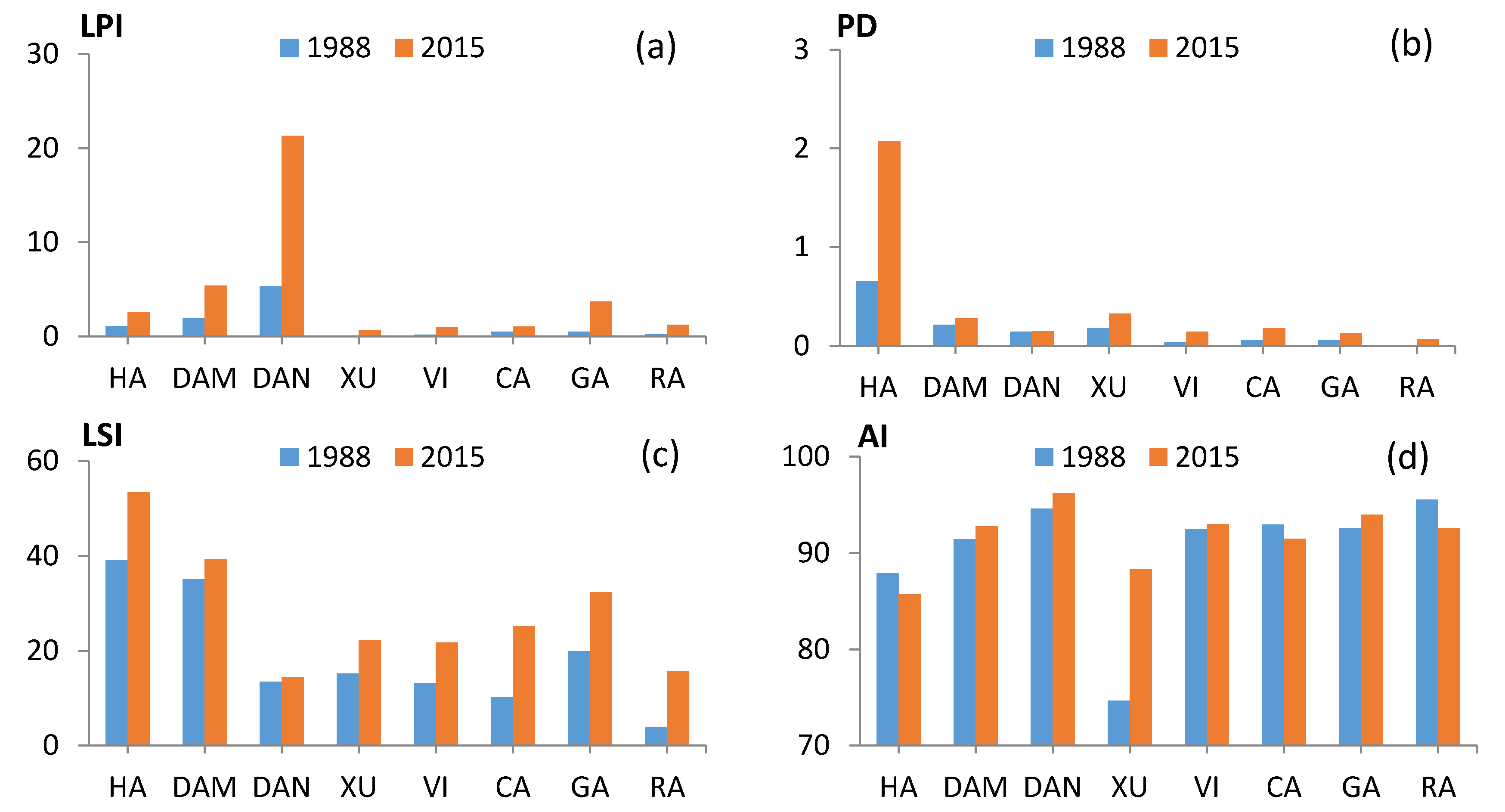
Figure 6 shows the proportions and areas of construction land in each bay. Except for the AIs, the bay-level LPIs, PDs and LSIs in 2015 were greater than those in 1988. This result indicated that the distribution of construction land became more fragmented, and the shape tended to become more complex over 30 years. There was a significant increase in the LPIs of Hai Loc Bay, Dam Ha Trung Bay, Danang Bay and Ganh Rai Bay. In Danang Bay, the LPIs were significantly greater than in the other bays and increased by more than three times until 2015. In the other four bays, the LPIs were very low with little change. The PDs and LSIs in Hai Loc Bay were much greater than those in other bays in both periods. Especially for the PDs, it increased to 2.0928 in 2015, which was more than 5 times the PDs of the other bays. Moreover, the lowest PDs and LSIs were recorded in Rạch Giá Bay. The changes in the AIs were relatively random. The most obvious change was in Xuan Dai Bay. The AIs increased from 74.6706 to 88.3288, and the ranking increased from 8th to 7th.
We standardized the four indicators (the PD, LPI, LSI and AI) and used the K-mean classification method. After the tests, we divided the bays into four clusters into both periods. The classification results for 1988 can be expressed as follows:
Cluster 1 = {Hai Loc Bay, Dam Ha Trung Bay}
Cluster 2 = {Danang Bay}
Cluster 3 = {Xuan Dai Bay}
Cluster 4 = {Vinh Van Phong Bay, Cam Ranh Bay, Ganh Rai Bay, Rạch Giá Bay}
The classification results for 2015 can be expressed as follows:
Cluster 1 = {Hai Loc Bay}
Cluster 2 = {Dam Ha Trung Bay, Ganh Rai Bay}
Cluster 3 = {Danang Bay}
Cluster 4 = {Xuan Dai Bay, Vinh Van Phong Bay, Cam Ranh Bay, Rạch Giá Bay}
According to the classification results, we identified the following five patterns.
(1) High intensity-high concentration pattern. Typical features of this pattern were high LPIs, high AIs and low LSIs. The construction land in such bays presented an aggregated distribution, and the patches had larger areas and regular shapes. Danang Bay presented this pattern in two periods. The LPI in Danang Bay was much greater than in other bays, and it increased dramatically in the 30 year period. The AIs in Danang Bay were also high among those of all the bays. This result indicated that the construction land in Danang Bay had experienced dramatic outward expansion.
(2) High intensity-low concentration. Typical features of this pattern were high PDs, high LSIs and low AIs. The construction land in such bays was densely distributed with relatively small and complex patches. Hai Loc Bay and Dam Ha Trung Bay presented this pattern in 1988. Dam Ha Trung Bay converted to pattern 3 in 2015. The PDs and LSIs in Hai Loc Bay were much greater than those in other bays. In 2015, the gap had widened, which indicated that the construction land in Hai Loc Bay had expanded dramatically based on the maintenance of a relatively discrete distribution.
(3) Medium intensity-medium concentration pattern. Typical features of this pattern were medium LPIs, LSIs and AIs. Dam Ha Trung Bay and Ganh Rai Bay presented this pattern in 2015. The LPIs in the two bays were just lower than those in Danang Bay, and the LSIs were just lower than those in Hai Loc Bay. Among them, Dam Ha Trung Bay was converted from pattern 2 (high intensity-high dispersion pattern) to pattern 3 from 1988 to 2015. The change indicated that Dam Ha Trung Bay experienced moderate expansion, and the expansion tended to be clustered.
(4) Low intensity-medium concentration pattern. The PDs, LPIs and LSIs were at a low level, while the AIs were at a medium or high level. Vinh Van Phong Bay, Cam Ranh Bay, Ganh Rai Bay and Rạch Giá Bay presented this pattern in 1988. However, Ganh Rai Bay was converted to pattern 3 (medium intensity-medium concentration pattern) in 2015. This result indicated that Ganh Rai Bay experienced moderate expansion based on the maintenance of a relatively concentrated distribution. In addition, Xuan Dai Bay converted to pattern 4 in 2015.
(5) Low intensity-low concentration pattern. The LPIs, LSIs and AIs were at a low level. Construction land in such bays was sparsely distributed with small patches. Xuan Dai Bay presented this pattern in 1988. The LPI and AI were the lowest among all bays. In 2015, Xuan Dai Bay converted to pattern 4 (low intensity-medium concentration pattern). This result indicated that Xuan Dai Bay experienced moderate expansion and that the expansion tended to be concentrated in certain areas.
3.3. Vertical Trends
The overall proportions of construction land in each zone are shown in
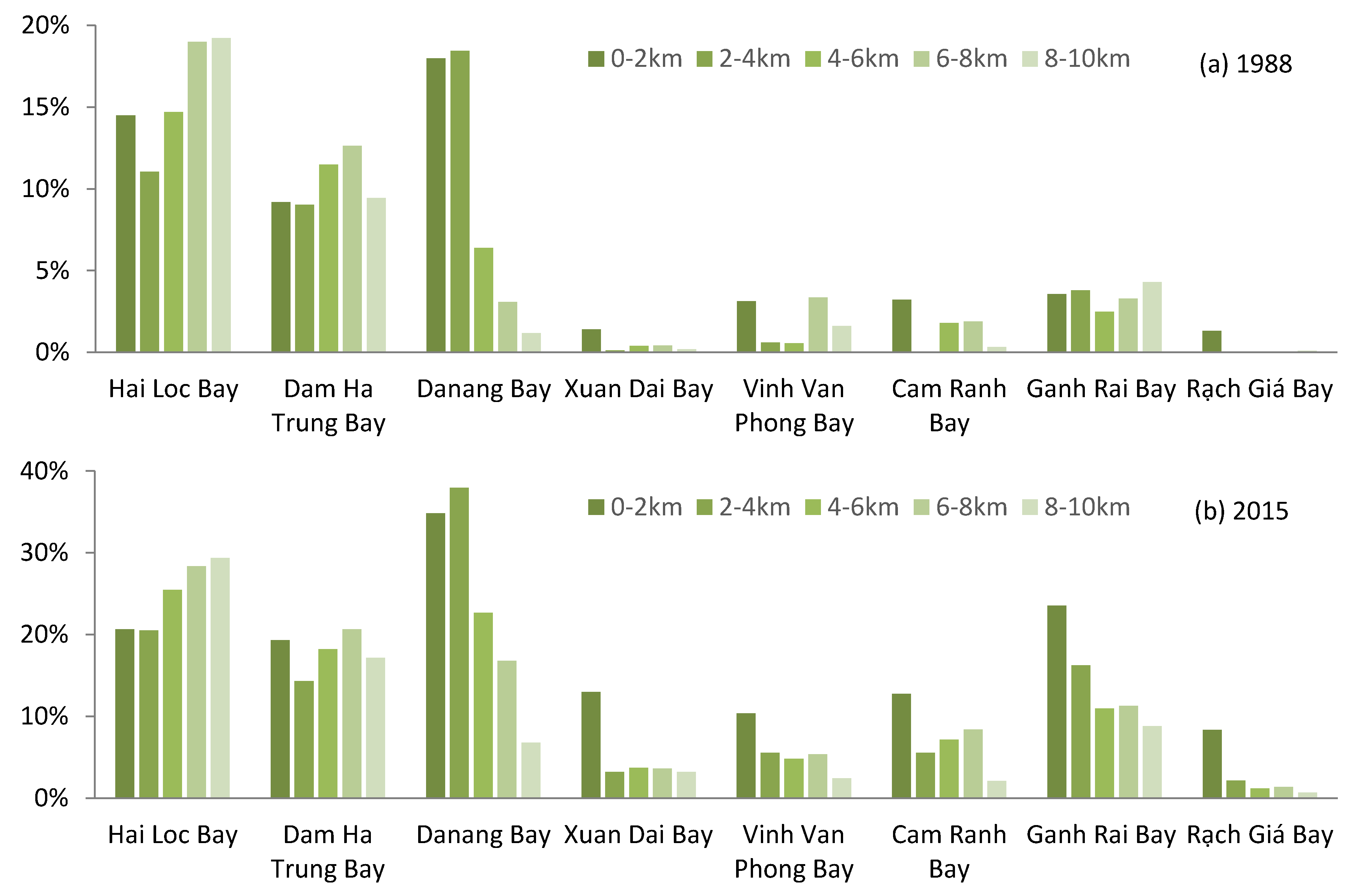
Table 8. In 1988, the proportion of construction land showed a trend of decrease–increase–decrease with two peaks, one in 0–2 km zone and another in 6–8 km zone. After 30 years of rapid construction sprawl, the proportions in all the zones increased greatly. The rapid pace of the construction sprawl occurred in the 0–2 km zone, and the proportion rose to 17.1%. The growth rate was much greater than that in other zones. In the 2–4 km, 4–6 km and 6–8 km zones, the growth rate was approximately 6.5%. The proportions in the 8–10 km zone were relatively low, and the growth rate was the lowest. The results suggested that the proportions of construction land decreased as the distance from the sea increased. The gap has widened over the following 30 years.
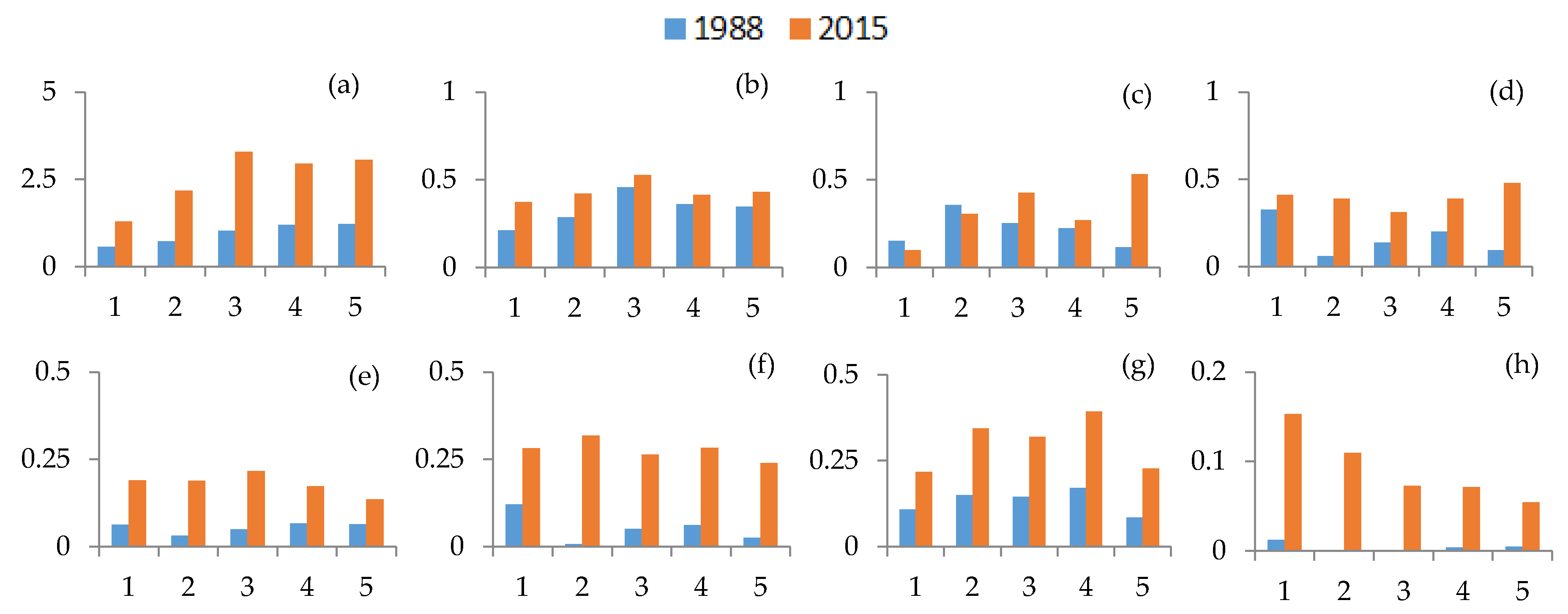
The proportions of construction land in each zone and each bay are shown in
Figure 7. The results can be discussed in two ways according to the proportion of construction land. In the bays with high construction land density, the distributions of construction land in the five zones were similar in the two periods. The results suggested that the construction land expanded inside the zone. In Hai Loc Bay and Dam Ha Trung Bay, the distribution of construction land in each zone was relatively even. The built-up density in the inland zone was slightly greater than that in the seaward zone. In Danang Bay, the construction land was concentrated in the 0–2 km and 2–4 km zones in both 1988 and 2015. From the 4–6 km zone to the 6–8 km zone to the 8–10 km zone, the proportion of construction land decreased successively. Otherwise, in the bays with low construction land density, the distributions of construction land in the five zones in 2015 were different from the distributions in 1988. The rate of construction sprawl in the 0–2 km zone was obviously greater than that in the other zones. In the other zones, the construction land expanded randomly.
3.4. Spatial Trends with Distance from Coast
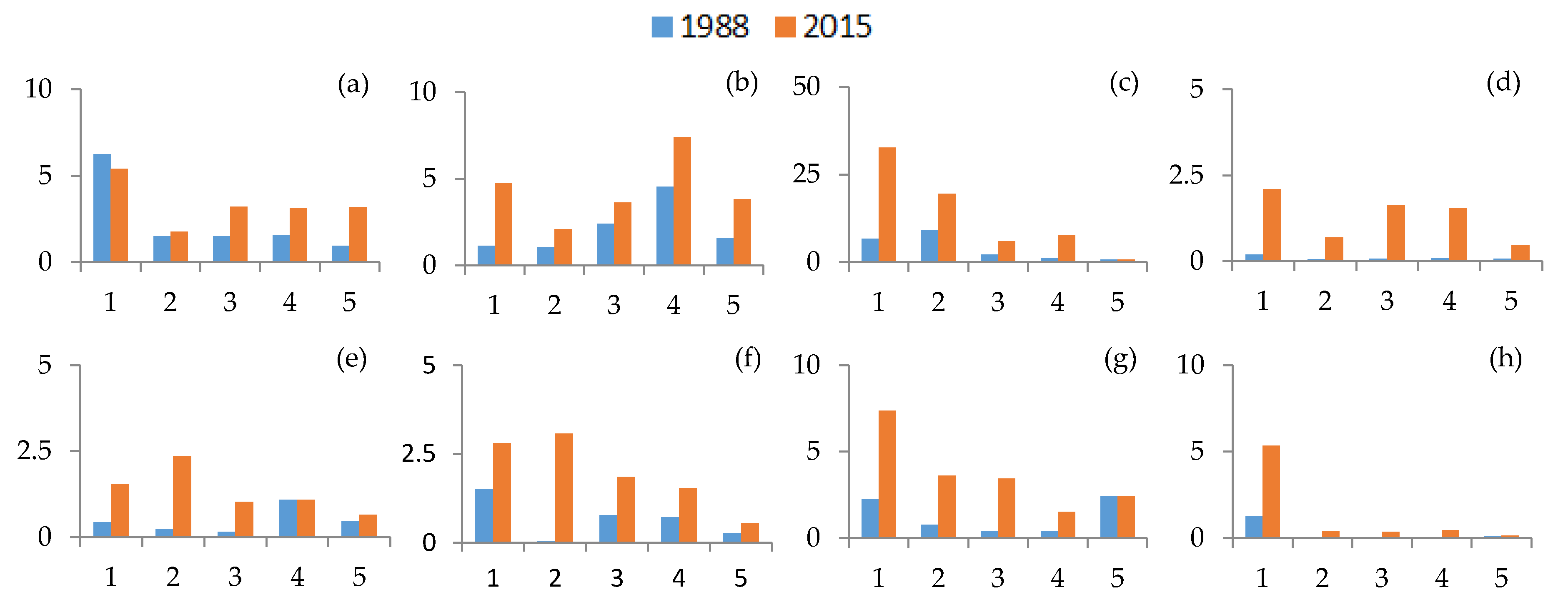
Figure 8 shows the distribution of the LPIs in the five buffers of the bays in the two periods. In 1988, half of the bays had the greatest LPIs in the 0–2 km zone. In 2015, a total of five bays had the greatest LPIs in the 0–2 km zone. In the remaining three bays (Dam Ha Trung Bay, Cam Ranh Bay and Vinh Van Phong Bay), the LPIs in the 0–2 km zone ranked second. The results suggested that construction tended to be concentrated in the seaward buffer zones. Except for the rapid increase in the LPIs in the 0–2 km zone, the LPIs increased in the other zones. In Hai Loc Bay, Dam Ha Trung Bay and Xuan Dai Bay, the increase in LPIs in landward zones (4–10 km zone) exceeded those in the 2–4 km zone. This result indicated that new construction hotspots were emerging.
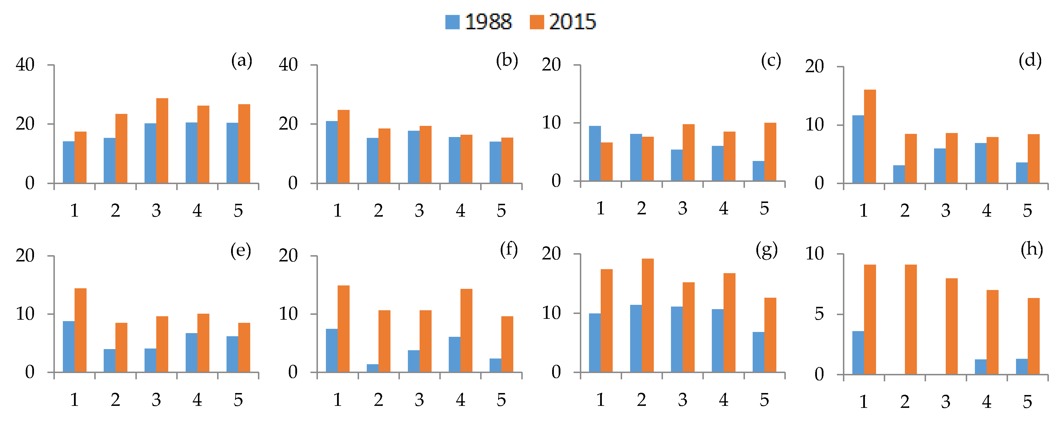
Figure 9 shows the distribution of the PDs in the five buffers of the bays in the two periods. Over the study period, the PDs increased in almost all zones and all bays. Among them, the PDs in Hai Loc Bay were much greater than those in other bays, and the increase of the PDs was also the greatest. From the distribution throughout all zones, the PDs in the 0–2 km zone ranked lowest or second-lowest in Hai Loc Bay, Dam Ha Trung Bay, Danang Bay and Ganh Rai Bay. Accordingly, the four bays had the greatest proportion of construction land. Additionally, the PDs generally showed an increasing trend from the 0–2 km zone to the 8–10 km zone, especially in the first three zones (0–6 km zone). In other bays, the PDs changed little or decreased in the five zones. The results suggested that the fragmentation degree was related to the development degree. In the highly developed bays, the construction land showed an aggregated distribution in the 0–2 km zone. As the distance from the sea increased, the construction land tended to be more fragmented.
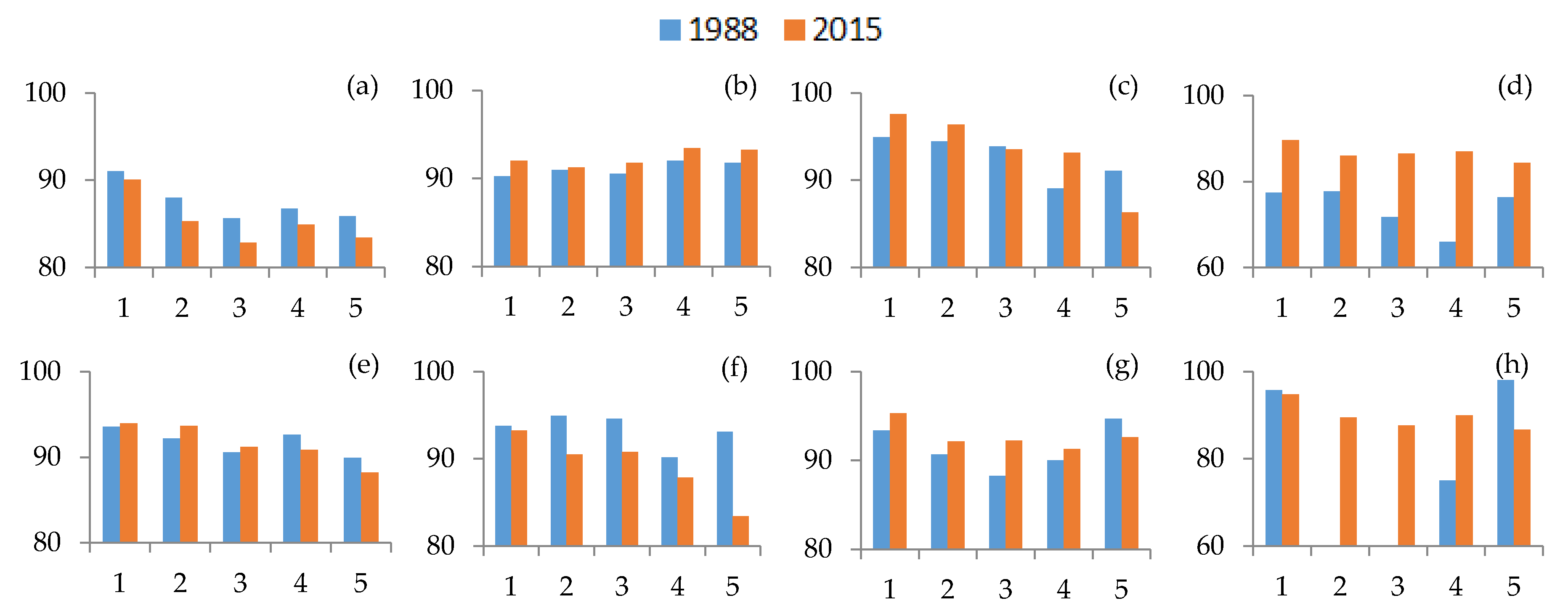
Figure 10 shows the distribution of the LSIs in the five buffers of the bays in the two periods. Over the period, the LSIs increased in all zones and all bays except Danang Bay. In Danang Bay, the LSIs in the 0–2 km zone and 2–4 km zone decreased in 1988. As the development degree increased, the construction land tended to gather, and the shape tended to be simple. In most bays except Hai Loc Bay and Danang Bay, the LSIs generally showed a decreasing trend from the 0–2 km zone to the 8–10 km zone. The results suggested that as the distance from the sea increased, the proportion of construction land tended to decrease, and the shape tended to be simpler.
Figure 11 shows the distribution of the AIs in the five buffers of the bays in the two periods. In most bays except Dam Ha Trung Bay, the AIs generally showed a decreasing trend from the 0–2 km zone to the 8–10 km zone. The results suggested that as the distance from the sea increased, the construction land tended to be more discrete.
4. Discussion
Landscapes influence the proportions and spatial forms of construction land in the bays.
Table 9 shows the bay types as well as the proportions and spatial patterns of construction land in each bay. The bays with high construction land proportions belonged to delta bay, bedrock erosion-stacking bay and lagoon bay. The influence of these three types of bays on the distribution of construction land is discussed next.
- (1)
Delta Bay
Deltas are the result of sediment accumulation in estuaries and adjacent areas when rivers enter the sea [
46]. Deltas and their estuaries hold both ecological and economic value and are major centers of population and agriculture [
47]. A delta bay is a bay formed with the development of a constructive delta [
39]. It is easy to convert agricultural infrastructure into urban infrastructure in the urban fringe of deltaic cities [
48]. In return, the intensity of development in the delta bay is often high. Hai Loc Bay and Ganh Rai Bay are delta bays located in the two largest deltas in Vietnam—the northern Red River Delta and the southern Mekong River Delta, respectively (
Figure 12). These two deltas are currently agricultural hotspots of Vietnam, contributing 71% of the rice production, 86% of the farmed aquaculture and 65% of the fruit production of the country [
49]. Hanoi city and Ho Chi Minh City are the largest cities in the two river deltas, as well as the largest cities in Vietnam. The built-up areas in Hanoi and in Ho Chi Minh have expanded in the past 20 years [
50,
51]. Correspondingly, the densities of the built-up areas were high in the two bays, and the growth rates of construction land were also very high. The proportions of construction land increased from 15.4% to 24.5% and from 3.5% to 15.4% in Hai Loc Bay and Ganh Rai Bay, respectively.
The terrain of the bay has a great influence on the spatial forms of construction. The delta area often has a dense water network, flat terrain, fertile soil, developed agriculture. The river network in the Red River Delta is quite dense, with a density of about 0.7 km/km
2 [
52]. The Mekong Delta river network is relatively dense and complex and includes natural river systems as well as manmade canals [
53]. In this case, it was easy to form dense rural settlements, especially in the narrow border road of the rice field [
54]. In terms of spatial form, Hai Loc Bay presented the HL pattern in the two periods. The construction land in Hai Loc Bay had the characteristics of high density and discrete distribution. Meanwhile, the proportion of construction land was even in each zone. At the edge of the bay, there are large uninhabitable depressions, leading to an increase in the proportion of construction land in the sea–land direction. The spatial form of construction land in Ganh Rai Bay was different from that in Hai Loc Bay. Ganh Rai Bay is located in the transitional zone between the southeast platform and the Mekong Delta region. Correspondingly, the construction land in the deltaic area was also relatively discrete, which was similar to that in Hai Loc Bay. In the eastern area of Ganh Rai Bay, the construction land was concentrated in the seaward zone, showing significantly banded distributions.
- (2)
Lagoon Bay
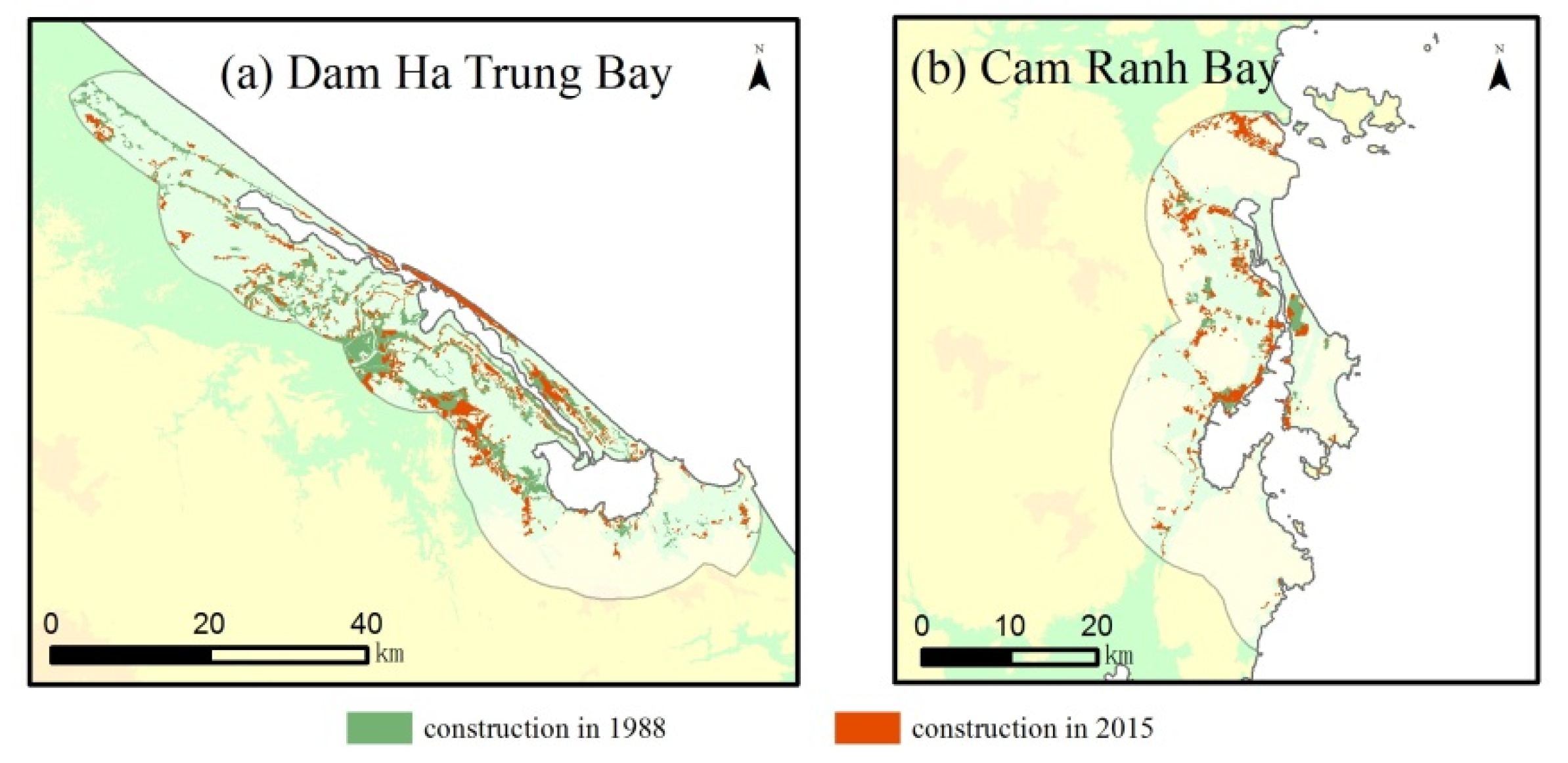
A lagoon bay is semi-enclosed water composed of a lagoon. The influx of nutrients from many inland rivers entering the lagoon supports high levels of primary productivity in the lagoon. This productivity, in turn, supports fishery production. Aquaculture and fishery capture are considered the most important sources of income in the region [
55]. In addition, the sandbanks outside the lagoon can be used as breakwaters, which are suitable for small and medium-sized ports. This has a radiating effect on the mainland economy. Dam Ha Trung Bay and Cam Ranh Bay are located at Tam Giang-Cau Hai Lagoon and Thuy Trieu Lagoon, respectively (
Figure 13). In terms of spatial form, Dam Ha Trung Bay and Cam Ranh Bay presented the MM pattern. The proportion of construction land in Dam Ha Trung Bay was greater than that in Cam Ranh Bay. The Tam Giang-Cau Hai Lagoon, where Dam Ha Trung Bay is located, lies along the central coastal line of Vietnam. The lagoon runs nearly 70 km along the coast and covers 219.18 km
2 of the water surface, forming the largest lagoon system in Southeast Asia [
55,
56]. Thuy Trieu Lagoon, where Cam Ranh Bay is located, is a narrow enclosed water body in southeastern Khanh Hoa Province that is approximately 16 km in length, 250 m in width and 0.5 to 6 m in depth [
57]. The lagoons experienced the rapid expansion of areas devoted to aquaculture activities (notably, culture ponds) [
56,
57]. Accordingly, many settlements are scattered along the bay coast. In addition, the developed agriculture in inland areas also gave rise to regional agricultural centers. The distribution of construction land appeared two peaks in 0–2 km zone and 6–8 km zone. From the perspective of the spatial morphology, the construction land in the two bays presented blocked or banded distributions.
- (3)
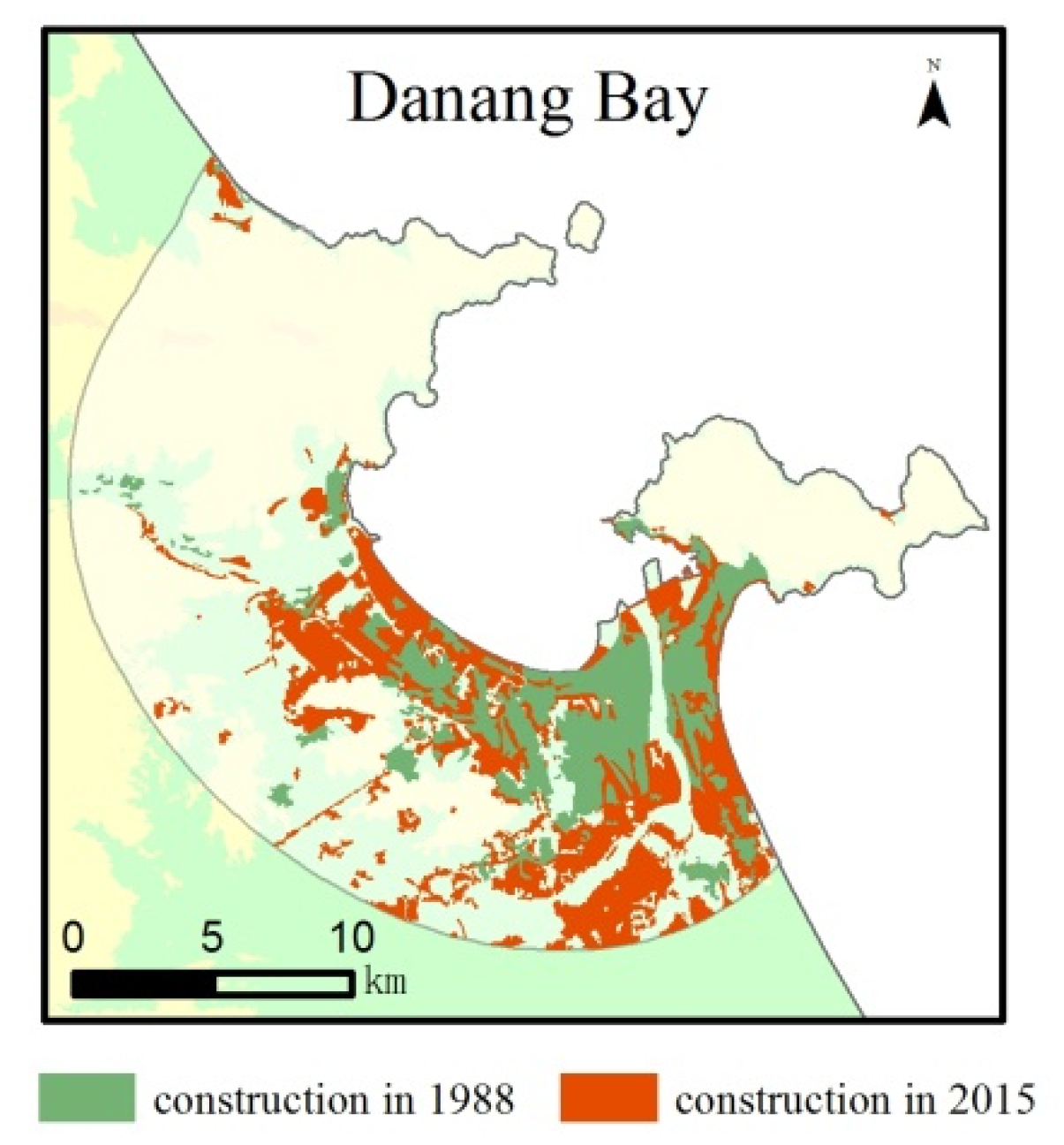
Bedrock erosion-stacking bay
A bedrock erosion-stacking bay is mainly a depression or valley formed by long-term erosion of the rock fracture zone and seawater intrusion. The top of the bay often forms a sandy or tidal beach, and the two sides have bedrock capes [
40]. Semi-enclosed bedrock bays are natural deep-water harbors, and the tidal channels and scour troughs in these bays are natural channels. The urban layout gives priority to the bay, and the economic structure is mainly based on the bay. Port economy drives the development of the marine industry and the inland economy. Such bays have always been the focus of coastal zone development [
58]. Danang Bay is a bedrock erosion bay on the central coast of Vietnam (
Figure 14). Da Nang city, where Danang Bay is located, is the most dynamic city in the middle of central Vietnam [
59]. The proportion of construction land was greatest in Danang Bay in 2015, up to 26.5%. In terms of spatial form, Danang Bay presented the HH pattern in the two periods. The bay has lower terrains in the middle and hills on the two sides. The construction land was concentrated in central coastal plains with a high degree of aggregation. In the past 30 years, the construction land has expanded inland from the original core. The proportions of construction land decreased significantly in the sea–land direction. The major seaport in Vietnam—Da Nang port is located at the river mouth [
60]. The greatest density of construction land was also located in this region.


