Simulating Large-Scale 3D Cadastral Dataset Using Procedural Modelling


Abstract
1. Introduction
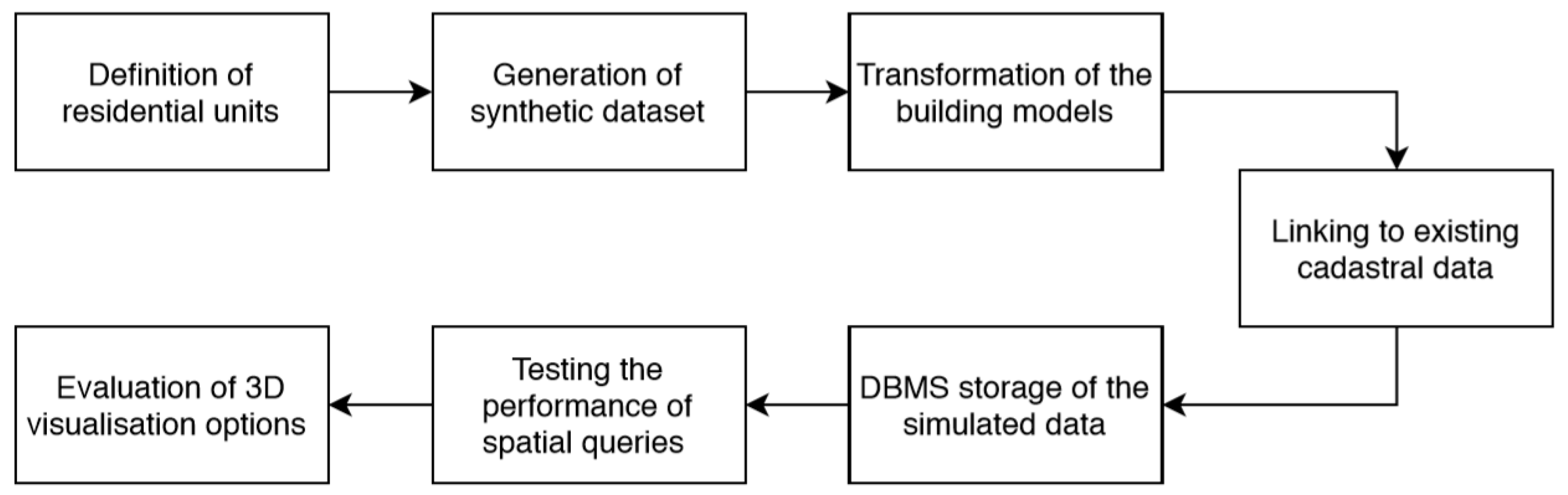
2. Materials and Methods
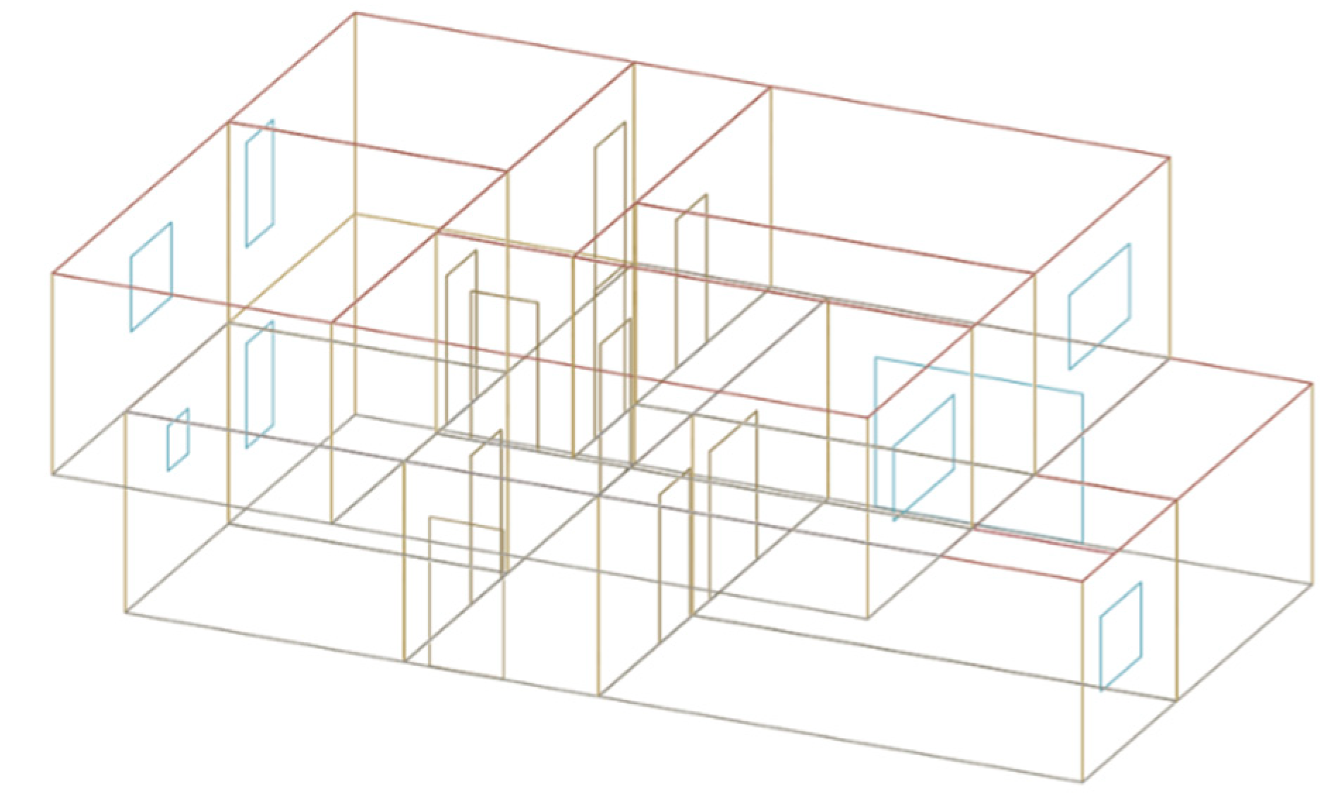
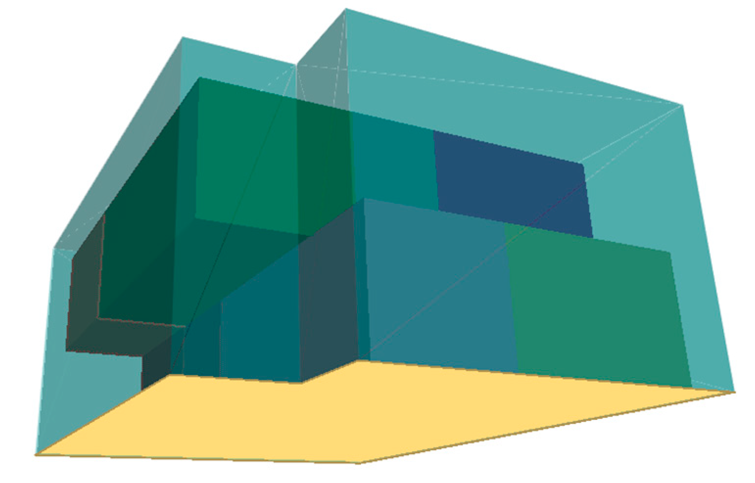
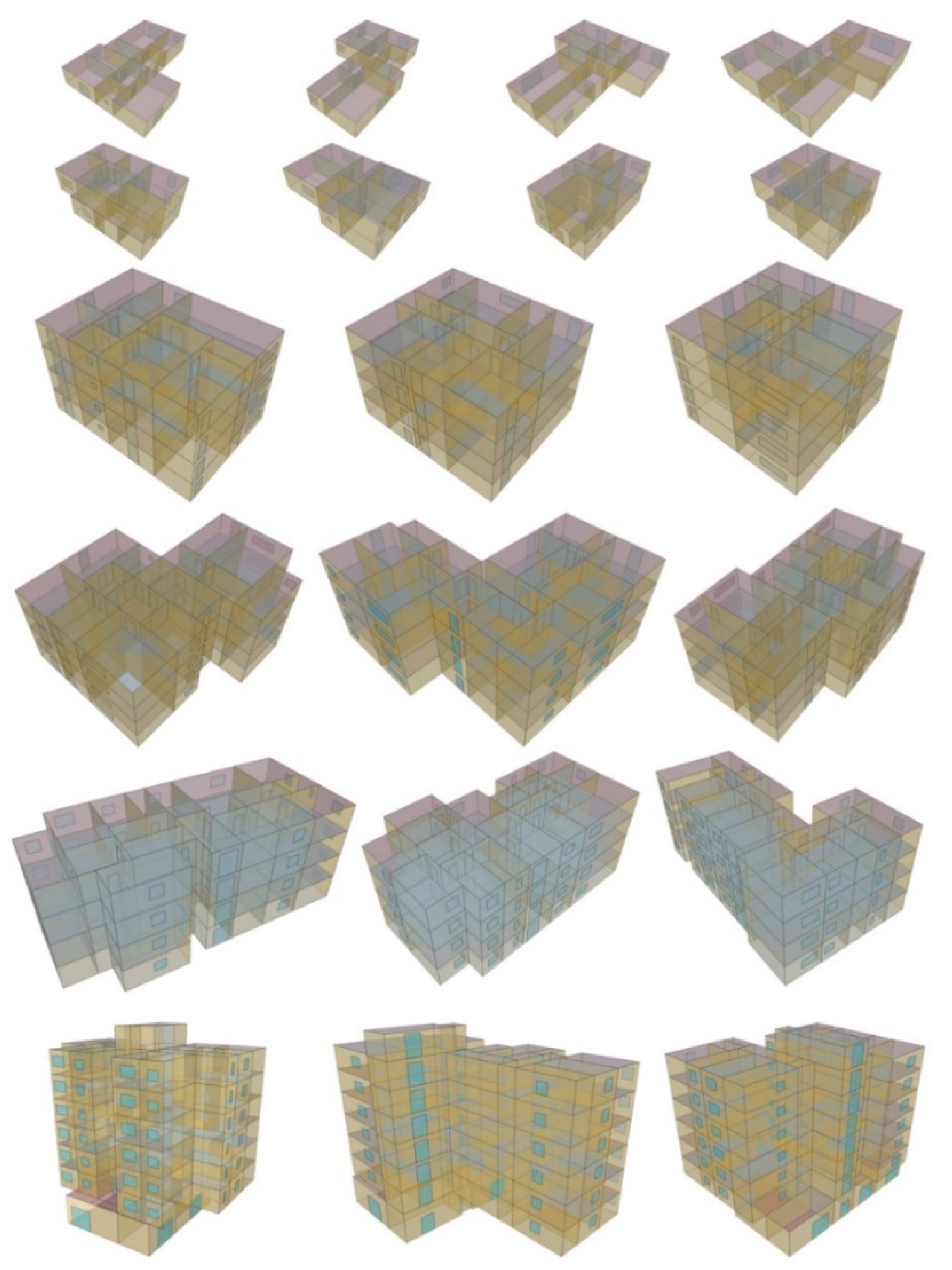
2.1. Procedural Modelling of Buildings
2.2. Transforming the Generated Building Models
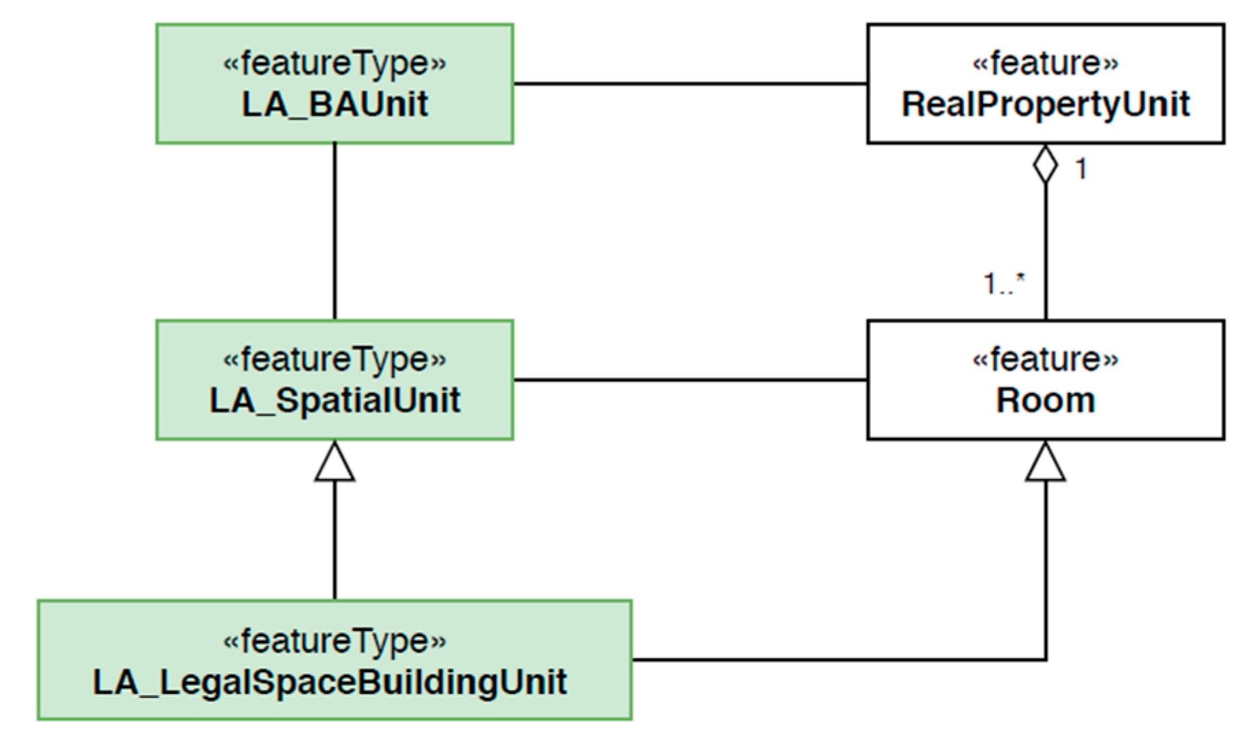
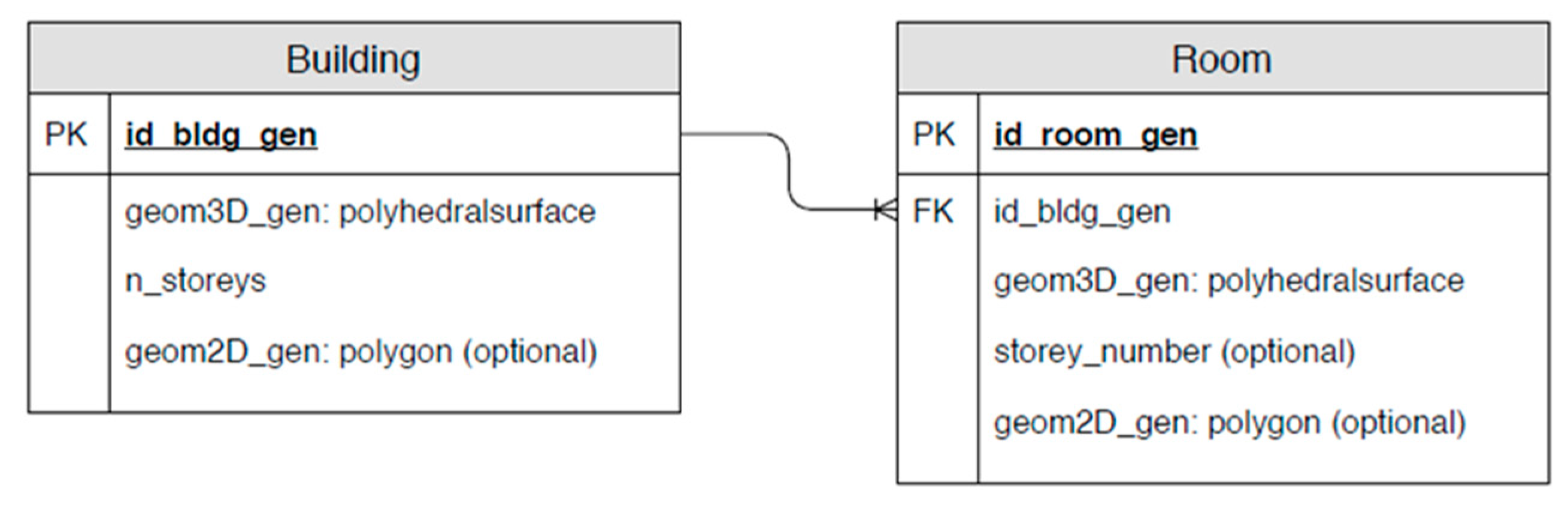
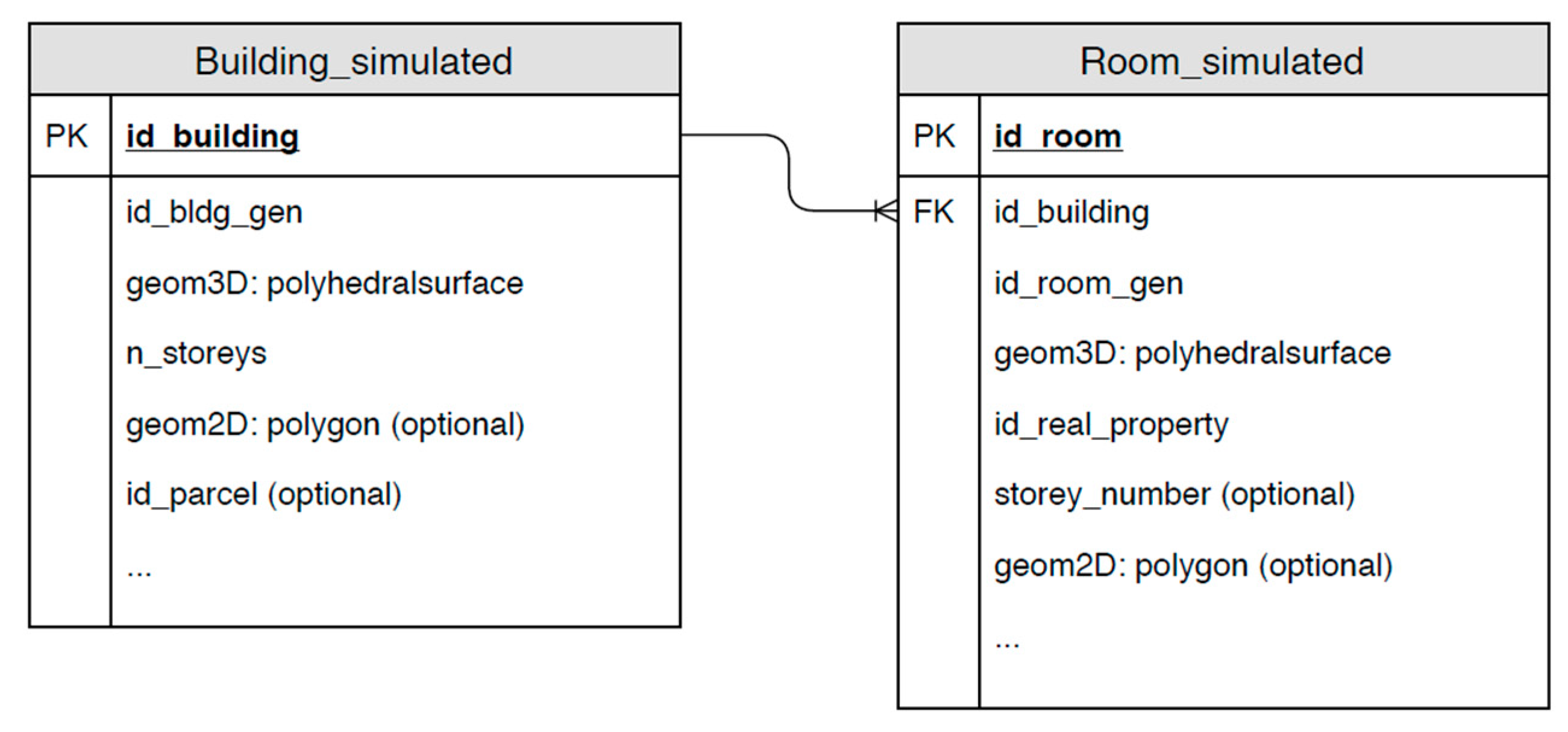
2.3. Georeferencing Using the Link to the Existing Cadastral Data
- Generate only one 3D model for each parameter: in our case, one model for each number of storeys. The same 3D model is selected for all buildings with the same number of storeys.
- Generate a given number of 3D models for each parameter (number of storeys). One of the 3D models is randomly selected and referenced to real cadastral data.
- Generate a random 3D model for each real building.
3. Results
4. Discussion
5. Conclusions
Supplementary Materials
Author Contributions
Funding
Conflicts of Interest
Appendix A
Appendix A.1. SQL Query to Select the Data for the Table Building_Simulated
- SELECT id_building, id_bldg_gen, n_storeys,
- ST_Translate(geom3d, ST_x(ST_GeometryN(geom_c,1)), ST_y(ST_GeometryN(geom_c,1)),h) as geom3d
- -- translation of in the x ynd y direction using ST_Translate function
- -- from 0,0 to the x,y of the centroid of the real building
- FROM cadastral_building
- JOIN building ON building.n_storeys = cadastral_building.n_storeys
- -- To each building from existing cadastral data, join the simulated
- -- building with the appropriate number of storeys
Appendix A.2. SQL Query to Select the Data for the Table Room_Simulated
- SELECT id_building, id_room_gen,
- ST_Translate(room.geom3d, ST_x(ST_GeometryN(geom_c,1)), ST_y(ST_GeometryN(geom_c,1)),h) as geom3d
- -- translation of in the x ynd y direction using ST_Translate function
- -- from 0,0 to the x,y of the centroid of the real building
- FROM cadastral_building
- JOIN building ON building.n_storeys = cadastral_building.n_storeys
- JOIN room ON room.id_bldg_gen = building.id_bldg_gen
- -- To each building from existing cadastral data, join the simulated
- -- building with the appropriate number of storeys and then join all the
- -- rooms that to this building
Appendix A.3. Modified A1 SQL Query (Modifications in Bold Text) to Select the Data for the Table Building_Simulated
- SELECT id_building, id_bldg_gen, n_storeys,
- ST_Translate(geom3d, ST_x(ST_GeometryN(geom_c,1)), ST_y(ST_GeometryN(geom_c,1)),h) as geom3d FROM (SELECT *, row_number() over(PARTITION BY id_building ORDER BY random()) as rn
- -- More than one simulated buildings join to each real building. Randomly
- -- assign row number to those simulated buildings
- FROM cadastral_building
- JOIN building ON building.n_storeys = cadastral_building.n_storeys) a
- WHERE a.rn = 1
- -- Take only the first of all the joined simulated buildings
Appendix A.4. Modified A2 SQL Query (Modifications in Bold Text) to Select the Data for the Table Room_Simulated
- SELECT id_building, id_room_gen,
- ST_Translate(room.geom3d, ST_x(ST_GeometryN(geom_c,1)), ST_y(ST_GeometryN(geom_c,1)),h) as geom3d
- FROM cadastral_building
- JOIN building_simulated ON building_simulated.id_building = cadastral_building.id_building
- -- The simulated building is randomly selected. Instead of joining the
- -- building table, we join building_simulated table
- JOIN room ON room.id_bldg_gen = building_simulated.id_bldg_gen
- -- We can join the corresponding room geometries of the assigned
- -- simulated building
Appendix A.5. Modified A3 SQL Query (Modifications in Bold Text) to Select the Data for the Table Building_Simulated
- SELECT id_building, id_bldg_gen, n_storeys, ST_Translate(geom3d, ST_x(ST_GeometryN(geom_c,1)), ST_y(ST_GeometryN(geom_c,1)),h) as geom3d
- FROM (SELECT *, row_number() over (PARTITION BY id_building ORDER BY random()) as rn
- FROM cadastral_building JOIN building ON
- CASE
- WHEN cadastral_building.n_storeys >= 8
- THEN building.n_storeys = 8
- WHEN cadastral_building.n_storeys >= 3 AND
- cadastral_building.n_storeys < 8
- THEN building.n_storeys = 4
- WHEN cadastral_building.n_storeys < 3
- THEN building.n_storeys = cadastral_building.n_storeys
- END) a WHERE a.rn = 1
- -- We limited the simulated buildings to 1, 2, 4 and 8 storeys. Real
- -- buildings have also other numbers of storeys. The above addition
- -- assigns the appropriate simulated building to the real building.
- -- For example, real building with 5 storeys gets 4 storey simulated
- -- building assigned
Appendix A.6. SQL Query that Checks for the Intersection of 3D Geometries in Building_Simulated Table
- SELECT a.id_building, b.id_building
- FROM building_simulated a, building_simulated b
- WHERE ST_3DIntersects(a.geom3d, b.geom3d)
- -- The contition – The output of the ST_3DIntersects function is boolean
- AND a.id_building != b.id_building
- -- With this condition we exclude the checking of the geometry against
- -- itself
Appendix A.7. SQL Query that Checks for the Overlap of 3D Geometries in Room_Simulated Table
- SELECT a.id_room, b.id_room, a.id_building FROM room_simulated a, room_simulated b
- WHERE ST_3DIntersects(a.geom3d, b.geom3d)
- AND ST_Volume(ST_MakeSolid(ST_3DIntersection(a.geom3d, b.geom3d))) != 0
- -- In addition to the ST_3DIntersects function, which is quick and removes
- -- all pairs that are not intersecting, we use ST_Intersection function
- -- and ST_Volume function to calculate the volume of the intersection. If
- -- the volume of the intersection is 0, then the geometries are in a
- -- touching relationship.
- AND a.id_room != b.id_room
- AND a.id_building = b.id_building
- -- In addition to excluding the checking of the geometry against
- -- itself, we use the condition to check only pairs of rooms in the
- -- same building
Appendix A.8. SQL Query that Checks for the Intersection of Room Geometries with Building Exterior Geometry
- SELECT a.id_room, b.id_building FROM room_simulated a
- JOIN building_simulated b ON a.id_building = b.id_building
- WHERE ST_3DIntersects(a.geom3d, b.geom3d)
- AND a.id_building = b.id_building
- -- This query has similar structure as A6. Instead of checking the pairs
- -- of building geometries, this query checks for the intersection of
- -- building geometry with room geometries that belong to the building.
References
- Kalogianni, E.; van Oosterom, P.; Dimopoulou, E.; Lemmen, C. 3D land administration: A review and a future vision in the context of the spatial development lifecycle. ISPRS Int. J. Geo-Inf. 2020, 9, 107. [Google Scholar] [CrossRef]
- Janečka, K.; Karki, S.; van Oosterom, P.; Zlatanova, S.; Kalantari, M.; Ghawana, T. 3D Spatial DBMS for 3D Cadastres. In 3D Cadastres Best Practices; van Oosterom, P., Ed.; International Federation of Surveyors (FIG): Copenhagen, Denmark, 2018; pp. 133–181. [Google Scholar]
- Jaljolie, R.; van Oosterom, P.; Dalyot, S. Spatial data structure and functionalities for 3d land management system implementation: Israel case study. ISPRS Int. J. Geo-Inf. 2018, 7, 10. [Google Scholar] [CrossRef]
- Paulsson, J. 3D Property Rights—An Analysis of Key Factors Based on International Experience. Ph.D. Thesis, Royal Institute of Technology, Stockholm, Sweden, 2007. [Google Scholar]
- Kitsakis, D.; Dimopoulou, E. 3D cadastres: Legal approaches and necessary reforms. Surv. Rev. 2014, 46, 322–332. [Google Scholar] [CrossRef]
- Paulsson, J.; Paasch, J. 3D property research from a legal perspective. Comput. Environ. Urban Syst. 2013, 40, 7–13. [Google Scholar] [CrossRef]
- Stoter, J.; Ploeger, H.; van Oosterom, P. 3D cadastre in the Netherlands: Developments and international applicability. Comput. Environ. Urban Syst. 2013, 40, 56–67. [Google Scholar] [CrossRef]
- Vučić, N.; Roić, M.; Mađer, M.; Vranić, S.; van Oosterom, P. Overview of the Croatian Land Administration System and the possibilities for its upgrade to 3D by existing data. ISPRS Int. J. Geo-Inf. 2017, 6, 223. [Google Scholar] [CrossRef]
- Shojaei, D.; Olfat, H.; Rajabifard, A.A.; Kalantari, M. Moving Towards a Fully Operational 3D Digital Cadastre: Victoria, Australia. In Proceedings of the 6th International FIG 3D Cadastre Workshop, Delft, The Netherlands, 1–5 October 2018. [Google Scholar]
- Janečka, K.; Souček, P. A Country Profile of the Czech Republic Based on an LADM for the Development of a 3D Cadastre. ISPRS Int. J. Geo-Inf. 2017, 6, 143. [Google Scholar] [CrossRef]
- Alkan, M.; Gürsoy Sürmeneli, H.; Polat, Z.A. Design and development 3D RRR model for Turkish cadastral system using international standards. Surv. Rev. 2020. [Google Scholar] [CrossRef]
- Ho, S.; Rajabifard, A.; Stoter, J.; Kalantari, M. Legal barriers to 3D cadastre implementation: What is the issue? Land Use Policy 2013, 35, 379–387. [Google Scholar] [CrossRef]
- Stoter, J. 3D Cadastre. Ph.D. Thesis, TU Delft, Delft, The Netherlands, 2004. [Google Scholar]
- Khuan, C.T.; Rahman, A.A.; Zlatanova, S. 3D solids and their management in DBMS. In Advances in 3D Geoinformation Systems; van Oosterom, P., Zlatanova, S., Penninga, F., Fendel, E., Eds.; Springer: Berlin/Heidelberg, Germany, 2008; pp. 279–311. [Google Scholar] [CrossRef]
- Višnjevac, N.; Mihajlović, R.; Šoškić, M.; Cvijetinović, Ž.; Bajat, B. Prototype of the 3D cadastral system based on a NoSQL database and a Javascript visualization application. ISPRS Int. J. Geo-Inf. 2019, 8, 227. [Google Scholar] [CrossRef]
- Zulkifli, N.A.; Rahman, A.A.; Siew, C.B. Database Design and Development of 3D Cadastral Registration based on LADM. In Proceedings of the 8th International FIG Workshop on the Land Administration Domain Model, Kuala Lumpur, Malaysia, 1–3 October 2019. [Google Scholar]
- Kazar, B.M.; Kothuri, R.; van Oosterom, P.; Ravada, S. On Valid and Invalid Three-Dimensional Geometries. In Advances in 3D Geoinformation Systems; van Oosterom, P., Zlatanova, S., Penninga, F., Fendel, E., Eds.; Springer: Berlin/Heidelberg, Germany, 2008; pp. 19–46. [Google Scholar] [CrossRef]
- Karki, S.; Thompson, R.; McDougall, K. Development of validation rules to support digital lodgement of 3D cadastral plans. Comput. Environ. Urban Syst. 2013, 40, 34–45. [Google Scholar] [CrossRef]
- Shojaei, D.; Olfat, H.; Ignacio, S.; Faundez, Q.; Kalantari, M.; Rajabifard, A.; Bri, M. Geometrical data validation in 3D digital cadastre—A case study for Victoria, Australia. Land Use Policy 2017, 68. [Google Scholar] [CrossRef]
- Shojaei, D.; Rajabifard, A.A.; Kalantari, M.; Bishop, I.D.; Aien, A. Design and development of a web-based 3D cadastral visualisation prototype. Int. J. Digit. Earth 2015, 8, 538–557. [Google Scholar] [CrossRef]
- Wang, C. 3D Visualization of Cadastre: Assessing the Suitability of Visual Variables and Enhancement Techniques in the 3D Model of Condominium Property Units. Ph.D. Thesis, Université Laval, Quebec City, QC, Canada, 2015. [Google Scholar]
- Aien, A.; Rajabifard, A.; Kalantari, M.; Williamson, I. Review and Assessment of Current Cadastral Data Models for 3D Cadastral Applications. In Advances in 3D Geoinformation, Lecture Notes in Geoinformation and Cartography; Rahman, A.A., Ed.; Springer: Berlin, Germany, 2017; pp. 423–442. [Google Scholar] [CrossRef]
- ISO 19152:2012—Geographic Information—Land Administration Domain Model (LADM); International Standard; International Organization for Standardization: Geneva Switzerland, 2012.
- Rajabifard, A.; Atazadeh, B.; Kalantari, M. A critical evaluation of 3D spatial information models for managing legal arrangements of multi-owned developments in Victoria, Australia. Int. J. Geogr. Inf. Sci. 2018, 32, 2098–2122. [Google Scholar] [CrossRef]
- Open Geospatial Consortium. City Geography Markup Language (CityGML) Encoding Standard, Version 2.0. 2012. Available online: http://www.opengeospatial.org/standards/citygml (accessed on 31 August 2020).
- Open Geospatial Consortium. IndoorGML, Version 1.02. 2014. Available online: http://www.opengeospatial.org/standards/indoorgml (accessed on 31 August 2020).
- Open Geospatial Consortium. Land and Infrastructure Conceptual Model Standard (LandInfra) Encoding Standard, Version 1.0. 2016. Available online: http://www.opengeospatial.org/standards/landinfra (accessed on 31 August 2020).
- Aien, A.; Kalantari, M.; Rajabifard, A.; Williamson, I.; Wallace, J. Towards integration of 3D legal and physical objects in cadastral data models. Land Use Policy 2013, 35, 140–154. [Google Scholar] [CrossRef]
- Stoter, J.; Ploeger, H.; Roes, R.; van der Riet, E.; Biljecki, F.; Ledoux, H.; Kok, D.; Kim, S. Registration of Multi-Level Property Rights in 3D in The Netherlands: Two Cases and Next Steps in Further Implementation. ISPRS Int. J. Geo-Inf. 2017, 6, 158. [Google Scholar] [CrossRef]
- Cemellini, B.; van Oosterom, P.; Thompson, R.; de Vries, M. Design, development and usability testing of an LADM compliant 3D Cadastral prototype system. Land Use Policy 2020, 98, 104418. [Google Scholar] [CrossRef]
- Larsson, K.; Paasch, J.M.; Paulsson, J. Representation of 3D cadastral boundaries—From analogue to digital. Land Use Policy 2020, 98, 104178. [Google Scholar] [CrossRef]
- Remondino, F.; Georgopoulos, A.; Gonzalez-Aguilera, D.; Agrafiotis, P. (Eds.) Latest Developments in Reality-Based 3D Surveying and Modelling; MDPI: Basel, Switzerland, 2018. [Google Scholar] [CrossRef]
- Gunduz, M.; Isikdag, U.; Basaraner, M. A review of recent research in Indoor modelling & mapping. ISPRS Int. Arch. Photogramm. Remote Sens. Spat. Inf. Sci. 2016, XLI-B4, 289–294. [Google Scholar] [CrossRef]
- Kitsakis, D.; Dimopoulou, E. Contribution of Existing Documentation to 3D Cadastre. In Proceedings of the 4th International FIG 3D Cadastre Workshop, Dubai, United Arab Emirates, 9–11 November 2014. [Google Scholar]
- Tekavec, J.; Lisec, A. Cadastral data as a source for 3D indoor modelling. Land Use Policy 2020, 98, 104322. [Google Scholar] [CrossRef]
- Ledoux, H.; Meijers, M. Topologically consistent 3D city models obtained by extrusion. Int. J. Geogr. Inf. Sci. 2011, 25, 557–574. [Google Scholar] [CrossRef]
- Biljecki, F.; Ledoux, H.; Stoter, J. Generating 3D city models without elevation data. Comput. Environ. Urban Syst. 2017, 64, 1–18. [Google Scholar] [CrossRef]
- Watson, B.; Muller, P.; Wonka, P.; Sexton, C.; Veryovka, O.; Fuller, A. Procedural urban modeling in practice. Comput. Graph. Appl. 2018, 28, 18–26. [Google Scholar] [CrossRef]
- Merrell, P.; Schkufza, E.; Koltun, V. Computer-generated residential building layouts. ACM Trans. Graph. 2010, 29, 181. [Google Scholar] [CrossRef]
- Smelik, R.M.; Tutenel, T.; Bidarra, R.; Benes, B. A survey on procedural modelling for virtual worlds. Comput. Graph. Forum 2014, 33, 31–50. [Google Scholar] [CrossRef]
- Camozzato, D. A Method for Growth-Based Procedural Floor Plan Generation. Ph.D. Thesis, Pontifícia Universidade Católica do Rio Grande do Sul, Porto Alegre, Brazil, 2015. [Google Scholar]
- Marson, F.; Musse, S.R. Automatic real-time generation of floor plans based on squarified treemaps algorithm. Int. J. Comput. Games Technol. 2010. [Google Scholar] [CrossRef]
- Peng, C.H.; Yang, Y.L.; Wonka, P. Computing layouts with deformable templates. ACM Trans. Graph. 2014, 33, 99. [Google Scholar] [CrossRef]
- Tutenel, T.; Bidarra, R.; Smelik, R.M.; de Kraker, K.J. Rule-based layout solving and its application to procedural interior generation. In Proceedings of the CASA Workshop on 3D Advanced Media in Gaming and Simulation, Amsterdam, The Netherlands, 17–19 June 2009. [Google Scholar]
- Rodrigues, E.; Gaspar, A.R.; Gomes, Á. An evolutionary strategy enhanced with a local search technique for the space allocation problem in architecture, Part 1: Methodology. Comput. Aided Des. 2013, 45, 887–897. [Google Scholar] [CrossRef]
- Gröger, G.; Plümer, L. Derivation of 3D Indoor Models by Grammars for Route Planning. Photogramm. Fernerkund. Geoinf. 2010, 191–206. [Google Scholar] [CrossRef]
- Zhu, J.; Zhang, H.; Chen, M.; Xu, Z.; Qi, H.; Yin, L.; Wang, J.; Hu, Y. A procedural modelling method for virtual high-speed railway scenes based on model combination and spatial semantic constraint. Int. J. Geogr. Inf. Sci. 2015, 29, 1059–1080. [Google Scholar] [CrossRef]
- Tsiliakou, E.; Labropoulos, T.; Dimopoulou, E. Procedural modelling in 3D GIS environment. Int. J. 3-D Inf. Model. 2014, 3, 17–34. [Google Scholar] [CrossRef]
- Kitsakis, D.; Tsiliakou, E.; Labropoulos, T.; Dimopoulou, E. Procedural 3D modelling for traditional settlements. The case study of central zagori. ISPRS Int. Arch. Photogramm. Remote Sens. Spat. Inf. Sci. 2017, 42, 369–376. [Google Scholar] [CrossRef]
- Ribeiro, A.; de Almeida, J.-P.; Ellul, C. Exploring CityEngine as a Visualisation Tool for 3D Cadastre. In Proceedings of the 4th International FIG 3D Cadastre Workshop, Dubai, United Arab Emirates, 9–11 November 2014. [Google Scholar]
- Neuenschwander, N.; Wissen Hayek, U.; Grêt-Regamey, A. Integrating an urban green space typology into procedural 3D visualization for collaborative planning. Comput. Environ. Urban Syst. 2014, 48. [Google Scholar] [CrossRef]
- Biljecki, F.; Ledoux, H.; Stoter, J. Generation of multi-LOD 3D city models in City GML with the procedural modelling engine Random3Dcity. ISPRS Ann. Photogramm. Remote Sens. Spat. Inf. Sci. 2016, IV-4/W1, 51–59. [Google Scholar] [CrossRef]
- Kumar, K.; Labetski, A.; Ledoux, H.; Stoter, J. An improved LOD framework for the terrains in 3D city models. ISPRS Ann. Photogramm. Remote Sens. Spat. Inf. Sci. 2019, IV-4/W8, 75–82. [Google Scholar] [CrossRef]
- Rodrigues, E.; Fernandes, M.S.; Gomes, Á.; Gaspar, A.R.; Costa, J.J. Performance-based design of multi-story buildings for a sustainable urban environment: A case study. Renew. Sustain. Energy Rev. 2019, 113. [Google Scholar] [CrossRef]
- Drobež, P.; Kosmatin Fras, M.; Ferlan, M.; Lisec, A. Transition from 2D to 3D real property cadastre—The case of the Slovenian cadastre. Comput. Environ. Urban Syst. 2017, 62, 125–135. [Google Scholar] [CrossRef]
- Atazadeh, B.; Kalantari, M.; Rajabifard, A.; Ho, S.; Ngo, T. Building Information Modelling for High-rise Land Administration. Trans. GIS 2017, 21, 91–113. [Google Scholar] [CrossRef]
- Li, L.; Wu, J.; Zhu, H.; Duan, X.; Luo, F. 3D modeling of the ownership structure of condominium units. Comput. Environ. Urban Syst. 2016, 59, 50–63. [Google Scholar] [CrossRef]
- Knoth, L.; Scholz, J.; Strobl, J.; Mittlböck, M.; Vockner, B.; Atzl, C.; Rajabifard, A.; Atazadeh, B. Cross-Domain Building Models—A Step towards Interoperability. ISPRS Int. J. Geo-Inf. 2018, 7, 363. [Google Scholar] [CrossRef]
- Oldfield, J.; van Oosterom, P.; Beetz, J.; Krijnen, T.F. Working with open BIM standards to source legal spaces for a 3D cadastre. ISPRS Int. J. Geo-Inf. 2017, 6, 351. [Google Scholar] [CrossRef]
- Barzegar, M.; Rajabifard, A.; Kalantari, M.; Atazadeh, B. 3D BIM-enabled spatial query for retrieving property boundaries: A case study in Victoria, Australia. Int. J. Geogr. Inf. Sci. 2020, 34, 251–271. [Google Scholar] [CrossRef]
- Rajabifard, A.; Atazadeh, B.; Kalantari, M. BIM and Urban Land Administration, 1st ed.; CRC Press: Boca Raton, FL, USA, 2019. [Google Scholar] [CrossRef]
- SFGGAL, Wrapper around CGAL Library for 2D and 3D Operations Based on OGC Standards. 2019. Available online: http://www.sfcgal.org (accessed on 31 August 2020).


© 2020 by the authors. Licensee MDPI, Basel, Switzerland. This article is an open access article distributed under the terms and conditions of the Creative Commons Attribution (CC BY) license (http://creativecommons.org/licenses/by/4.0/).
Share and Cite
Tekavec, J.; Lisec, A.; Rodrigues, E. Simulating Large-Scale 3D Cadastral Dataset Using Procedural Modelling. ISPRS Int. J. Geo-Inf. 2020, 9, 598. https://doi.org/10.3390/ijgi9100598
Tekavec J, Lisec A, Rodrigues E. Simulating Large-Scale 3D Cadastral Dataset Using Procedural Modelling. ISPRS International Journal of Geo-Information. 2020; 9(10):598. https://doi.org/10.3390/ijgi9100598
Chicago/Turabian StyleTekavec, Jernej, Anka Lisec, and Eugénio Rodrigues. 2020. "Simulating Large-Scale 3D Cadastral Dataset Using Procedural Modelling" ISPRS International Journal of Geo-Information 9, no. 10: 598. https://doi.org/10.3390/ijgi9100598
APA StyleTekavec, J., Lisec, A., & Rodrigues, E. (2020). Simulating Large-Scale 3D Cadastral Dataset Using Procedural Modelling. ISPRS International Journal of Geo-Information, 9(10), 598. https://doi.org/10.3390/ijgi9100598