Machine Learning Algorithms for Automatic Lithological Mapping Using Remote Sensing Data: A Case Study from Souk Arbaa Sahel, Sidi Ifni Inlier, Western Anti-Atlas, Morocco

 ,
,  and
and
Abstract
1. Introduction
2. Study Area Description
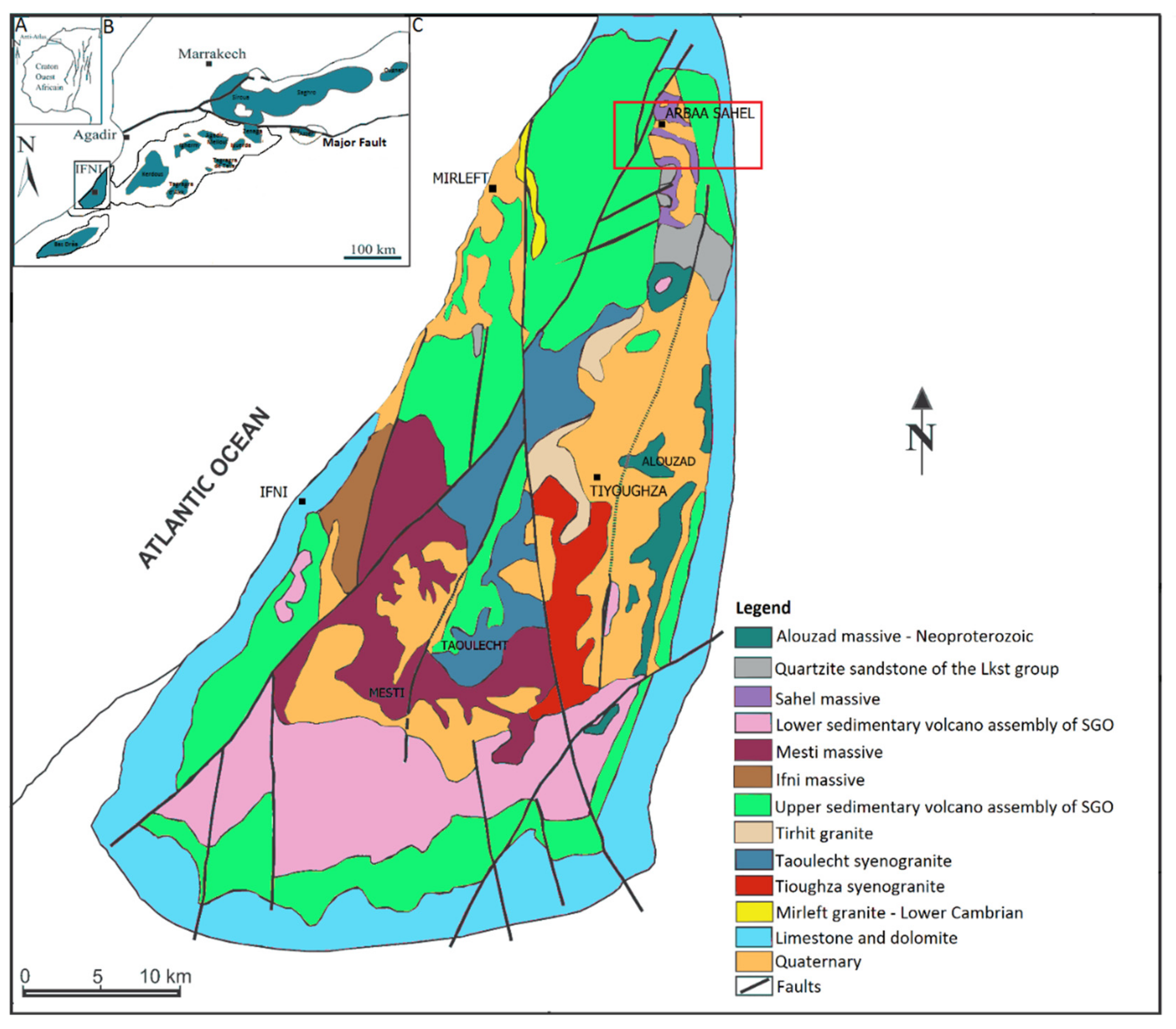
2.1. Geographical Location
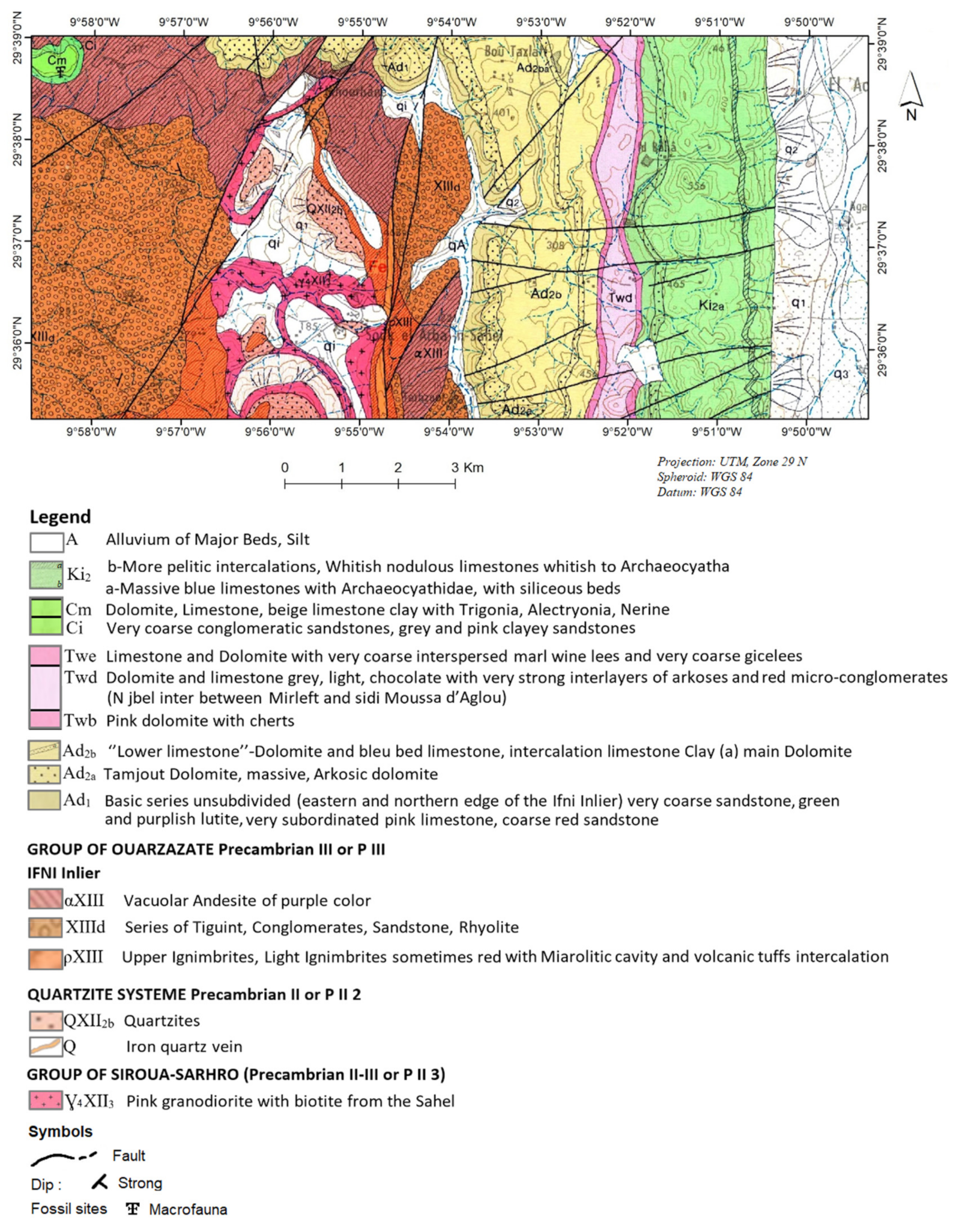
2.2. Geological Context
3. Materials and Methods
3.1. Landsat OLI Data
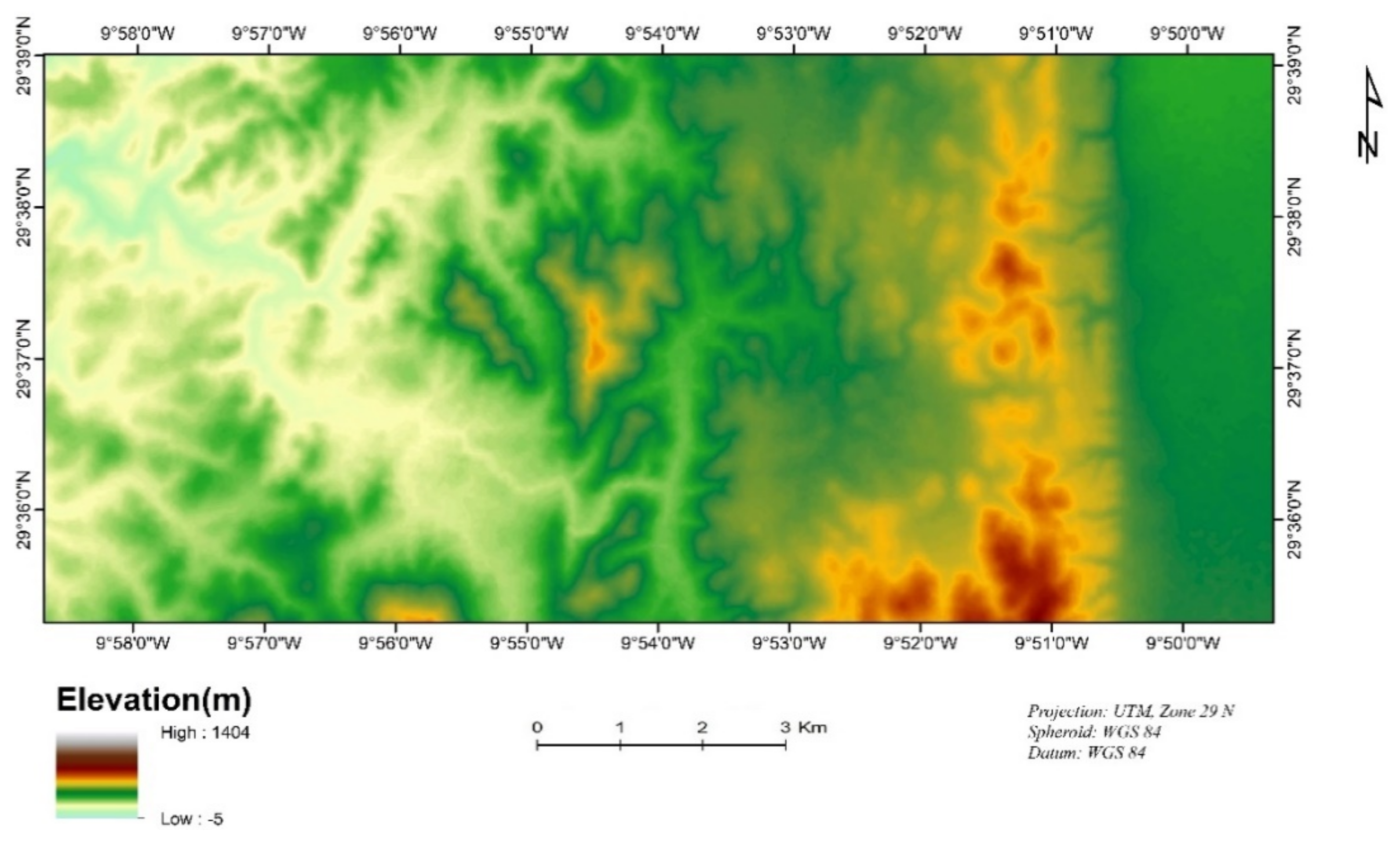
3.2. Digital Elevation Model
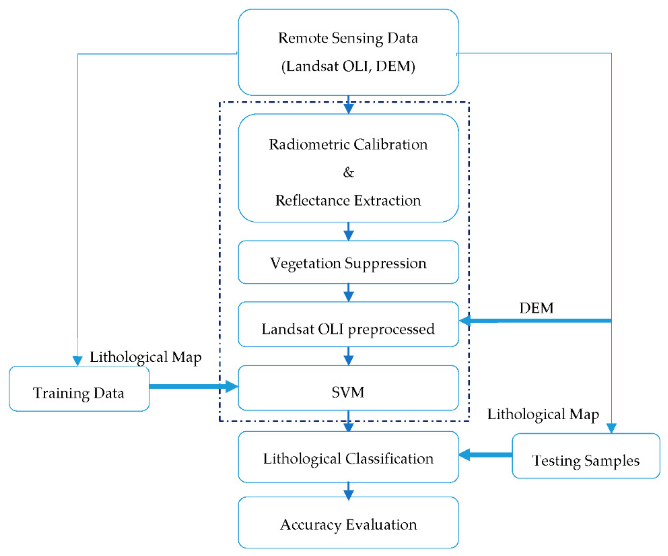
3.3. Methods
3.4. Pre-Processing of Remote-Sensing Data
3.4.1. Radiometric Calibration and Reflectance Conversion
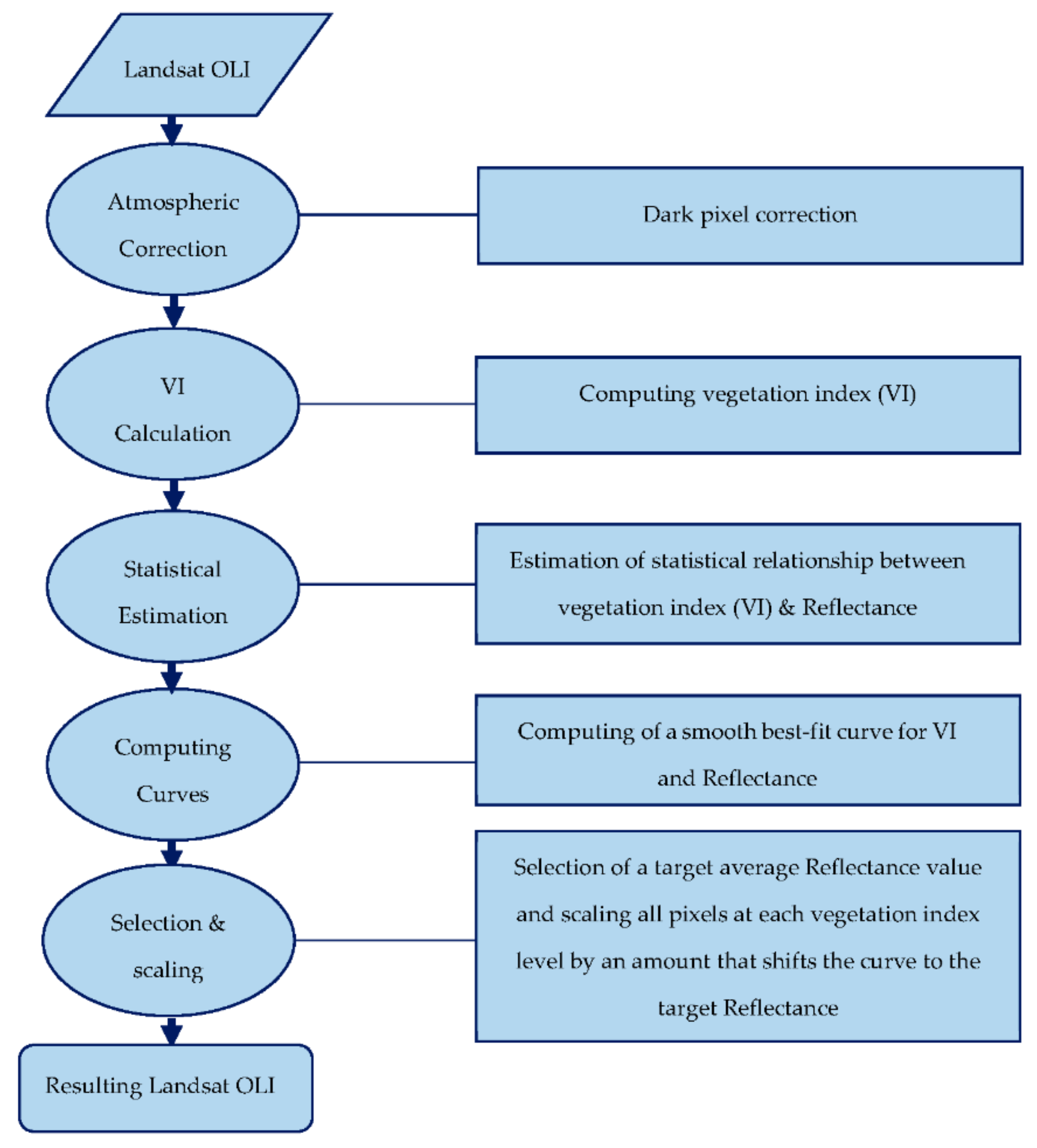
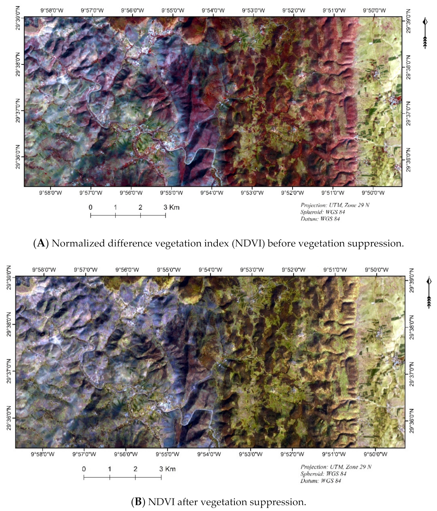
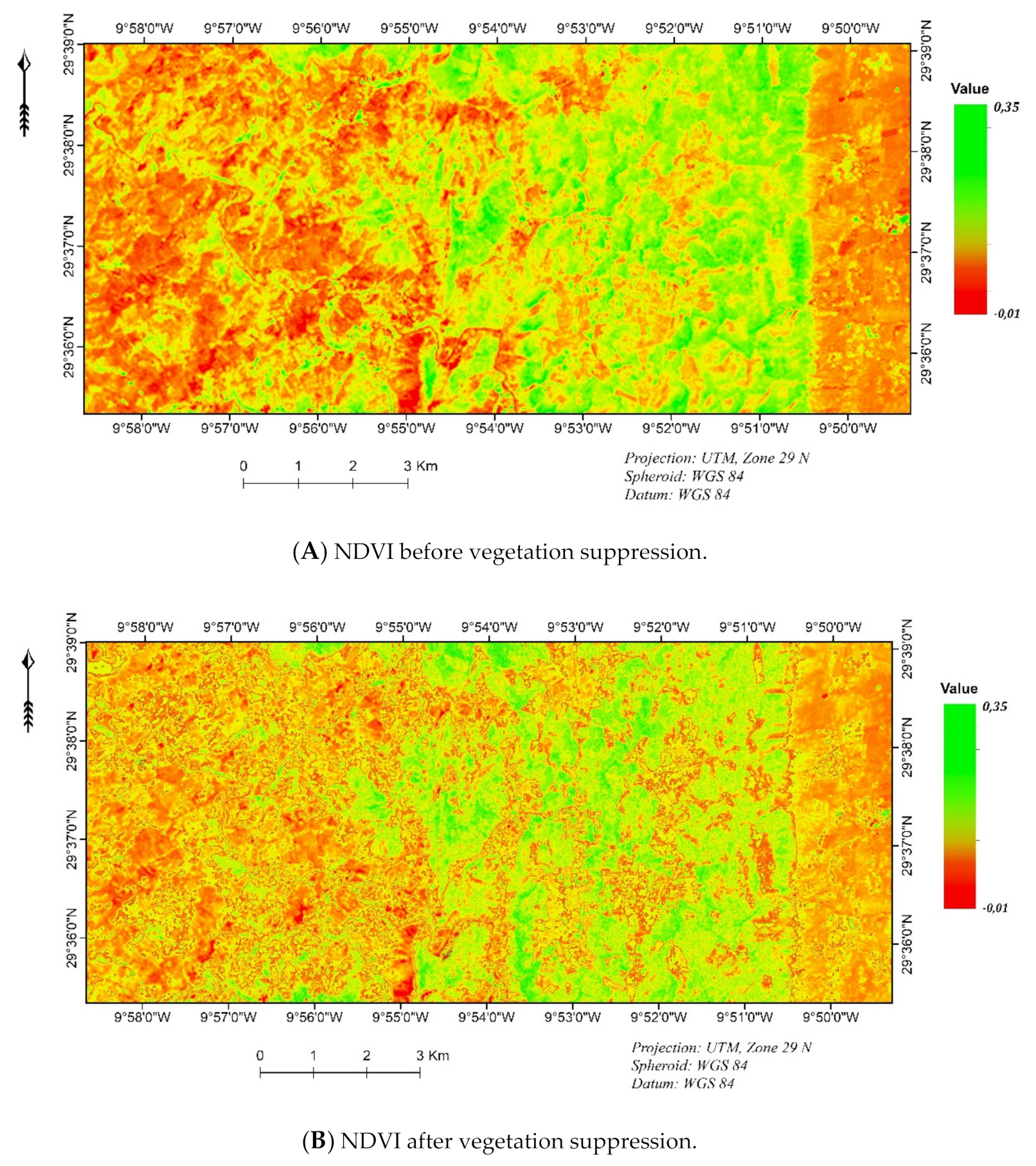
3.4.2. Vegetation Suppression Using the Forced Invariance Method
3.5. Training and Testing Samples
3.6. Lithological Mapping by SVM
3.7. Lithological Mapping by Artificial Neural Network
3.8. Accuracy Evaluation
4. Results
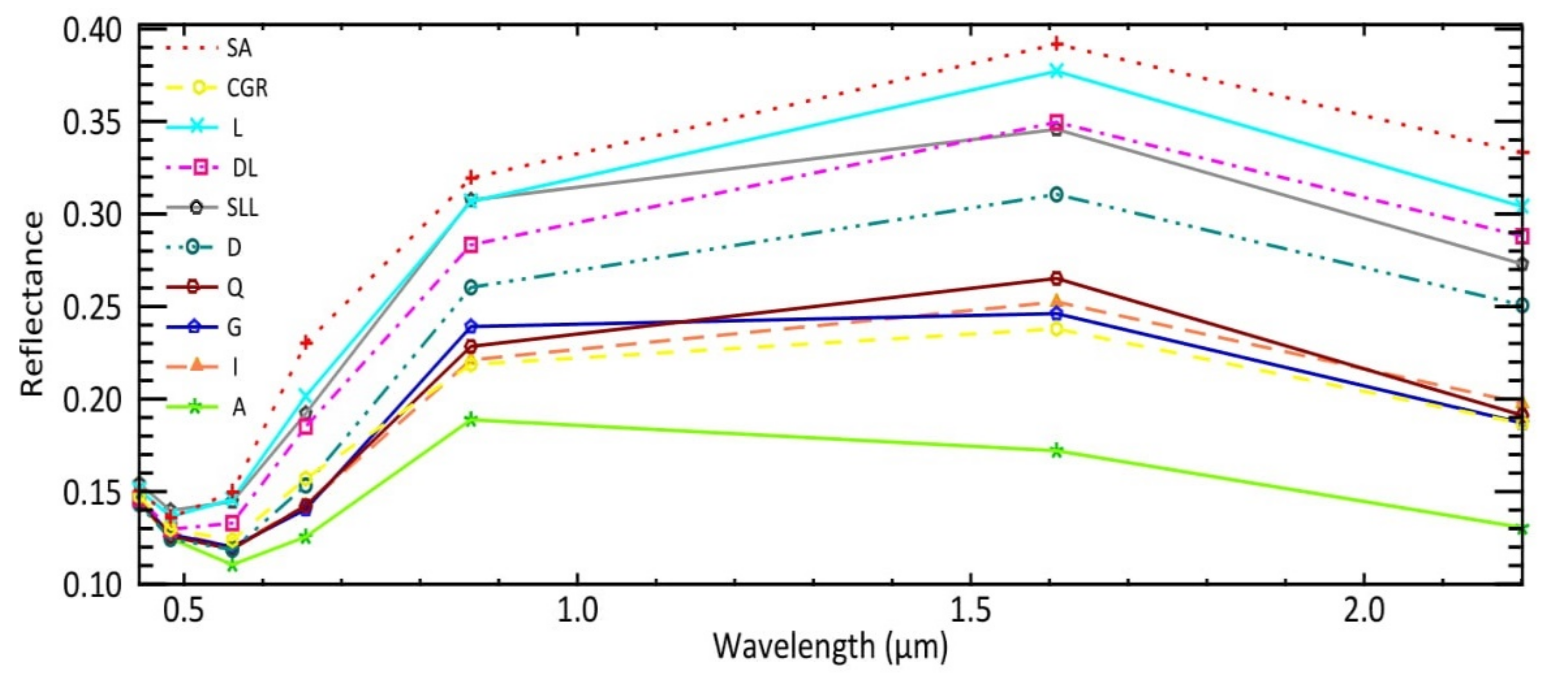
4.1. Training Area Statistics
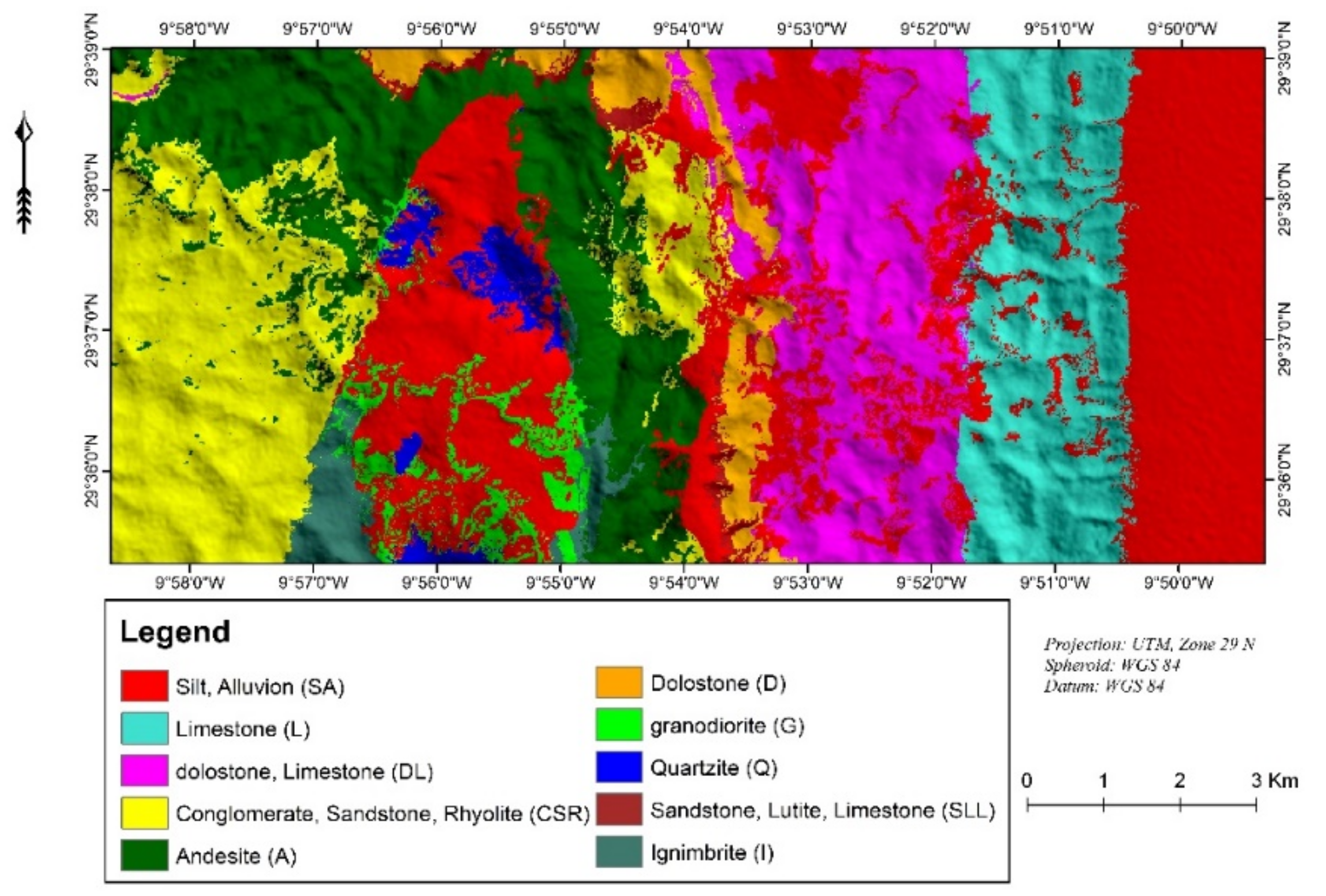
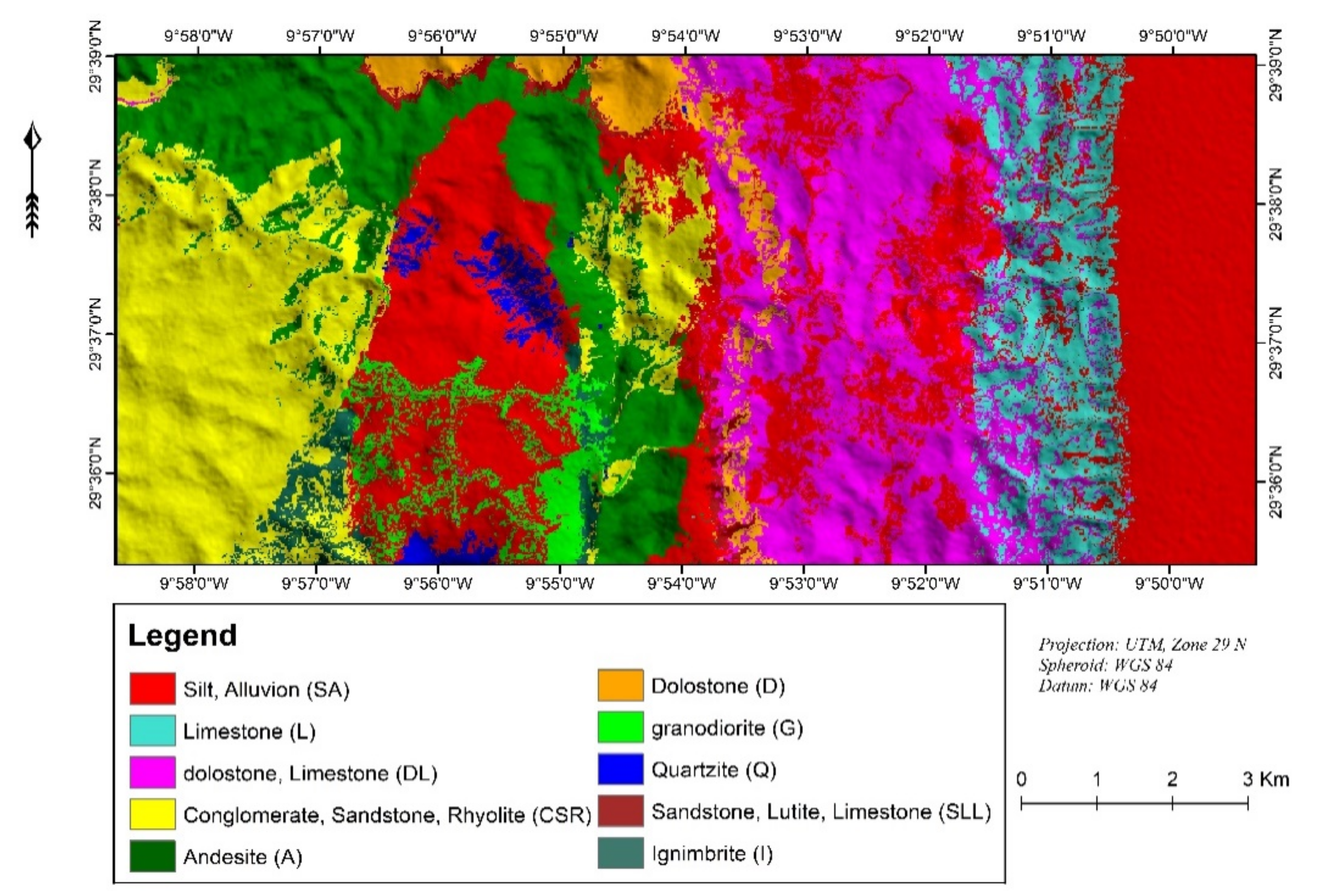
4.2. Lithological Classification Map
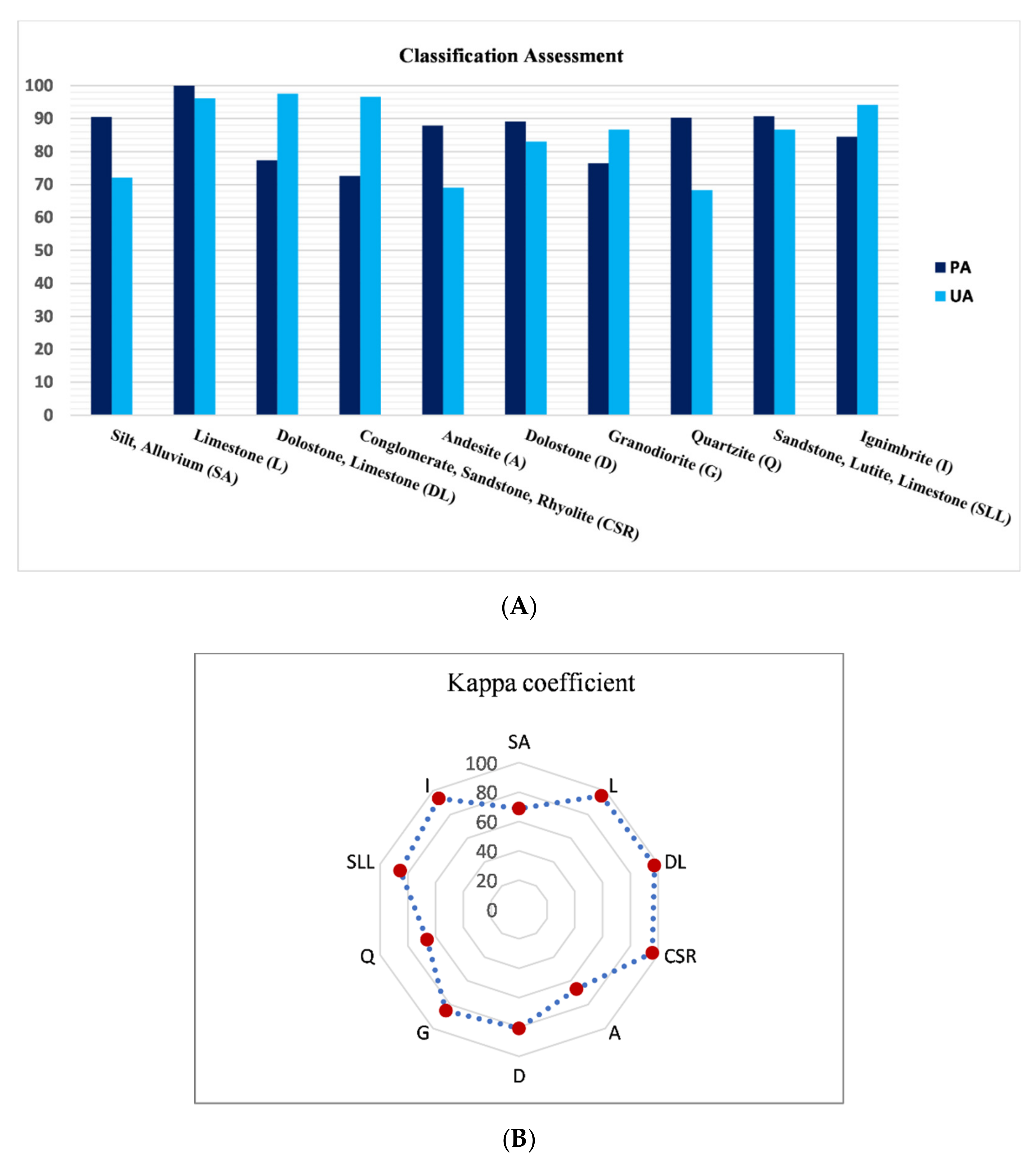
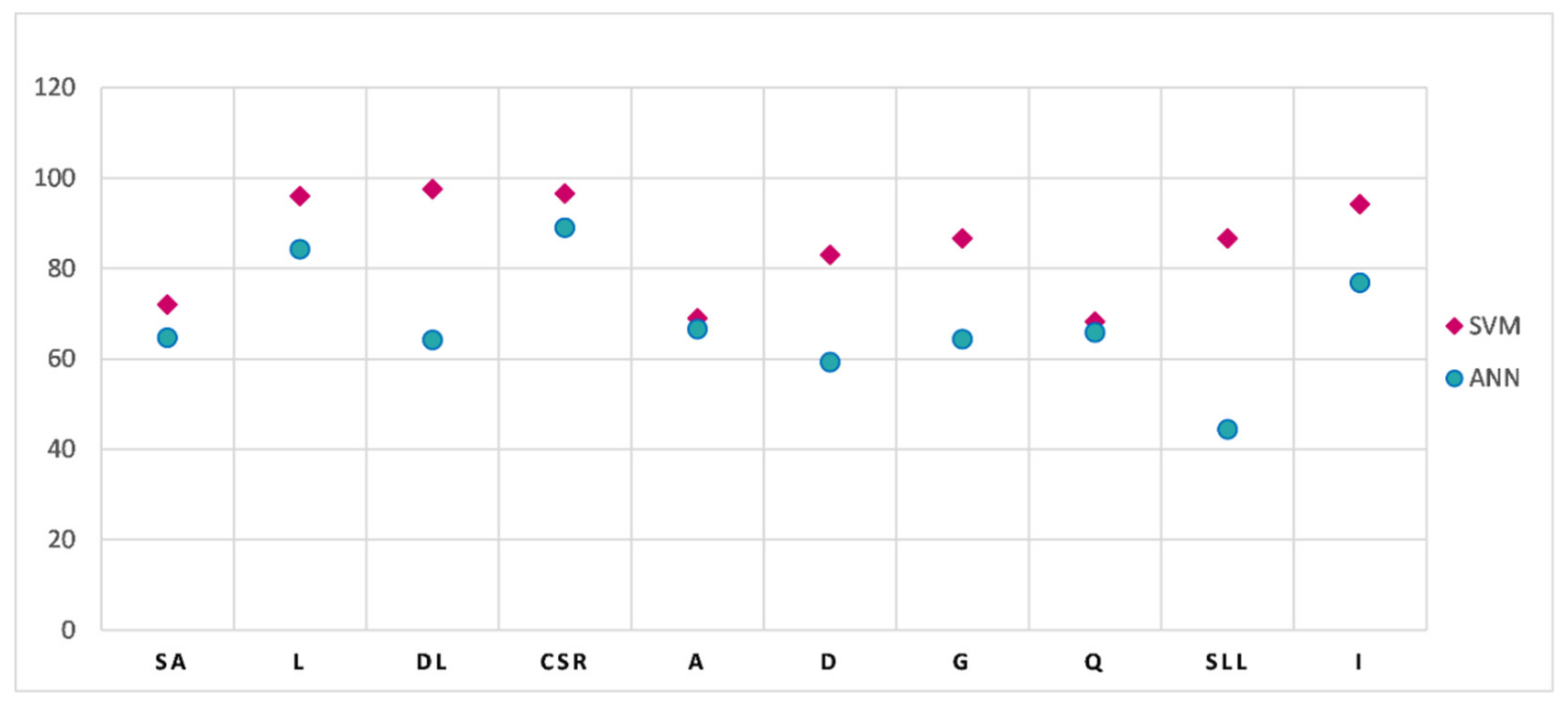
4.3. Classification Accuracy
5. Discussion
6. Conclusions
Author Contributions
Funding
Acknowledgments
Conflicts of Interest
References
- Ninomiya, Y.; Fu, B.; Cudahy, T.J. Detecting lithology with Advanced Spaceborne Thermal Emission and Reflection Radiometer (ASTER) multispectral thermal infrared “radiance-at-sensor” data. Remote Sens. Environ. 2005, 99, 127–139. [Google Scholar] [CrossRef]
- Gad, S.; Kusky, T. ASTER spectral ratioing for lithological mapping in the Arabian–Nubian shield, the Neoproterozoic Wadi Kid area, Sinai, Egypt. Gondwana Res. 2007, 11, 326–335. [Google Scholar] [CrossRef]
- Leverington, D.W.; Moon, W.M.; Leverington, D.W.; Moon, W.M. Landsat-TM-Based Discrimination of Lithological Units Associated with the Purtuniq Ophiolite, Quebec, Canada. Remote Sens. 2012, 4, 1208–1231. [Google Scholar] [CrossRef]
- Black, M.; Riley, T.R.; Ferrier, G.; Fleming, A.H.; Fretwell, P.T. Automated lithological mapping using airborne hyperspectral thermal infrared data: A case study from Anchorage Island, Antarctica. Remote Sens. Environ. 2016, 176, 225–241. [Google Scholar] [CrossRef]
- Pour, A.B.; Hashim, M.; Hong, J.K.; Park, Y. Lithological and alteration mineral mapping in poorly exposed lithologies using Landsat-8 and ASTER satellite data: North-eastern Graham Land, Antarctic Peninsula. Ore Geol. Rev. 2017. [Google Scholar] [CrossRef]
- Metelka, V.; Baratoux, L.; Jessell, M.W.; Barth, A.; Ježek, J.; Naba, S. Automated regolith landform mapping using airborne geophysics and remote sensing data, Burkina Faso, West Africa. Remote Sens. Environ. 2018, 204, 964–978. [Google Scholar] [CrossRef]
- Ninomiya, Y.; Fu, B. Thermal infrared multispectral remote sensing of lithology and mineralogy based on spectral properties of materials. Ore Geol. Rev. 2018. [Google Scholar] [CrossRef]
- Testa, F.; Villanueva, C.; Cooke, D.; Zhang, L. Lithological and Hydrothermal Alteration Mapping of Epithermal, Porphyry and Tourmaline Breccia Districts in the Argentine Andes Using ASTER Imagery. Remote Sens. 2018, 10, 203. [Google Scholar] [CrossRef]
- Raharimahefa, T.; Kusky, T.M. Structural and remote sensing analysis of the Betsimisaraka Suture in northeastern Madagascar. Gondwana Res. 2009, 15, 14–27. [Google Scholar] [CrossRef]
- Rowan, L.C.; Schmidt, R.G.; Mars, J.C. Distribution of hydrothermally altered rocks in the Reko Diq, Pakistan mineralized area based on spectral analysis of ASTER data. Remote Sens. Environ. 2006, 104, 74–87. [Google Scholar] [CrossRef]
- Kratt, C.; Calvin, W.M.; Coolbaugh, M.F. Mineral mapping in the Pyramid Lake basin: Hydrothermal alteration, chemical precipitates and geothermal energy potential. Remote Sens. Environ. 2010, 114, 2297–2304. [Google Scholar] [CrossRef]
- Zhang, T.; Yi, G.; Li, H.; Wang, Z.; Tang, J.; Zhong, K.; Li, Y.; Wang, Q.; Bie, X. Integrating Data of ASTER and Landsat-8 OLI (AO) for Hydrothermal Alteration Mineral Mapping in Duolong Porphyry Cu-Au Deposit, Tibetan Plateau, China. Remote Sens. 2016, 8, 890. [Google Scholar] [CrossRef]
- Vaughan, R.G.; Hook, S.J.; Calvin, W.M.; Taranik, J.V. Surface mineral mapping at Steamboat Springs, Nevada, USA, with multi-wavelength thermal infrared images. Remote Sens. Environ. 2005, 99, 140–158. [Google Scholar] [CrossRef]
- Vicente, L.E.; de Souza Filho, C.R. Identification of mineral components in tropical soils using reflectance spectroscopy and advanced spaceborne thermal emission and reflection radiometer (ASTER) data. Remote Sens. Environ. 2011, 115, 1824–1836. [Google Scholar] [CrossRef]
- Govil, H.; Gill, N.; Rajendran, S.; Santosh, M.; Kumar, S. Identification of new base metal mineralization in Kumaon Himalaya, India, using hyperspectral remote sensing and hydrothermal alteration. Ore Geol. Rev. 2018, 92, 271–283. [Google Scholar] [CrossRef]
- Mahanta, P.; Maiti, S. Regional scale demarcation of alteration zone using ASTER imageries in South Purulia Shear Zone, East India: Implication for mineral exploration in vegetated regions. Ore Geol. Rev. 2018, 102, 846–861. [Google Scholar] [CrossRef]
- Cardoso-Fernandes, J.; Teodoro, A.C.; Lima, A. Remote sensing data in lithium (Li) exploration: A new approach for the detection of Li-bearing pegmatites. Int. J. Appl. Earth Obs. Geoinf. 2019, 76, 10–25. [Google Scholar] [CrossRef]
- Chen, X.; Warner, T.A.; Campagna, D.J. Integrating visible, near-infrared and short-wave infrared hyperspectral and multispectral thermal imagery for geological mapping at Cuprite, Nevada: A rule-based system. Int. J. Remote Sens. 2010, 31, 1733–1752. [Google Scholar] [CrossRef]
- De Carneiro, C.C.; Fraser, S.J.; Crósta, A.P.; Silva, A.M.; de Barros, C.E.M. Semiautomated geologic mapping using self-organizing maps and airborne geophysics in the Brazilian Amazon. Geophysics 2012, 77, K17–K24. [Google Scholar] [CrossRef]
- Zhang, X.; Pazner, M.; Duke, N. Lithologic and mineral information extraction for gold exploration using ASTER data in the south Chocolate Mountains (California). ISPRS J. Photogramm. Remote Sens. 2007, 62, 271–282. [Google Scholar] [CrossRef]
- Yu, L.; Porwal, A.; Holden, E.-J.; Dentith, M.C. Towards automatic lithological classification from remote sensing data using support vector machines. Comput. Geosci. 2012, 45, 229–239. [Google Scholar] [CrossRef]
- Bedini, E. Mapping lithology of the Sarfartoq carbonatite complex, southern West Greenland, using HyMap imaging spectrometer data. Remote Sens. Environ. 2009, 113, 1208–1219. [Google Scholar] [CrossRef]
- Paasche, H.; Eberle, D. Automated compilation of pseudo-lithology maps from geophysical data sets: A comparison of Gustafson-Kessel and fuzzy c-means cluster algorithms. Explor. Geophys. 2011, 42, 275. [Google Scholar] [CrossRef]
- Sahoo, S.; Jha, M.K. Pattern recognition in lithology classification: Modeling using neural networks, self-organizing maps and genetic algorithms. Hydrogeol. J. 2017, 25, 311–330. [Google Scholar] [CrossRef]
- Behnia, P.; Harris, J.R.; Rainbird, R.H.; Williamson, M.C.; Sheshpari, M. Remote predictive mapping of bedrock geology using image classification of Landsat and SPOT data, western Minto Inlier, Victoria Island, Northwest Territories, Canada. Int. J. Remote Sens. 2012, 33, 6876–6903. [Google Scholar] [CrossRef]
- Ge, W.; Cheng, Q.; Tang, Y.; Jing, L.; Gao, C.; Ge, W.; Cheng, Q.; Tang, Y.; Jing, L.; Gao, C. Lithological Classification Using Sentinel-2A Data in the Shibanjing Ophiolite Complex in Inner Mongolia, China. Remote Sens. 2018, 10, 638. [Google Scholar] [CrossRef]
- Cracknell, M.J.; Reading, A.M. Geological mapping using remote sensing data: A comparison of five machine learning algorithms, their response to variations in the spatial distribution of training data and the use of explicit spatial information. Comput. Geosci. 2014, 63, 22–33. [Google Scholar] [CrossRef]
- Horrocks, T.; Holden, E.-J.; Wedge, D. Evaluation of automated lithology classification architectures using highly-sampled wireline logs for coal exploration. Comput. Geosci. 2015, 83, 209–218. [Google Scholar] [CrossRef]
- He, J.; Harris, J.R.; Sawada, M.; Behnia, P. A comparison of classification algorithms using Landsat-7 and Landsat-8 data for mapping lithology in Canada’s Arctic. Int. J. Remote Sens. 2015, 36, 2252–2276. [Google Scholar] [CrossRef]
- Gu, Y.; Bao, Z.; Rui, Z. Complex Lithofacies Identification Using Improved Probabilistic Neural Networks. Petrophysics 2018, 59, 245–267. [Google Scholar] [CrossRef]
- Latifovic, R.; Pouliot, D.; Campbell, J. Assessment of convolution neural networks for surficial geology mapping in the South Rae geological region, Northwest Territories, Canada. Remote Sens. 2018, 10, 307. [Google Scholar] [CrossRef]
- Kuhn, S.; Cracknell, M.J.; Reading, A.M. Lithologic mapping using Random Forests applied to geophysical and remote-sensing data: A demonstration study from the Eastern Goldfields of Australia. Geophysics 2018, 83, B183–B193. [Google Scholar] [CrossRef]
- Vapnik, V.N. The Nature of Statistical Learning Theory; Springer: New York, NY, USA, 1995; ISBN 978-1-4757-2442-4. [Google Scholar]
- Teodoro, A.C. Applicability of data mining algorithms in the identification of beach features/patterns on high-resolution satellite data. J. Appl. Remote Sens. 2015, 9, 095095. [Google Scholar] [CrossRef]
- Othman, A.; Gloaguen, R. Improving Lithological Mapping by SVM Classification of Spectral and Morphological Features: The Discovery of a New Chromite Body in the Mawat Ophiolite Complex (Kurdistan, NE Iraq). Remote Sens. 2014, 6, 6867–6896. [Google Scholar] [CrossRef]
- Ye, B.; Tian, S.; Ge, J.; Sun, Y. Assessment of WorldView-3 data for lithological mapping. Remote Sens. 2017, 9, 1132. [Google Scholar] [CrossRef]
- Deng, C.; Pan, H.; Fang, S.; Konaté, A.A.; Qin, R. Support vector machine as an alternative method for lithology classification of crystalline rocks. J. Geophys. Eng. 2017, 14, 341–349. [Google Scholar] [CrossRef]
- Othman, A.A.; Gloaguen, R. Integration of spectral, spatial and morphometric data into lithological mapping: A comparison of different Machine Learning Algorithms in the Kurdistan Region, NE Iraq. J. Asian Earth Sci. 2017, 146, 90–102. [Google Scholar] [CrossRef]
- Pal, M.; Mather, P.M. Support vector machines for classification in remote sensing. Int. J. Remote Sens. 2005, 26, 1007–1011. [Google Scholar] [CrossRef]
- Mortaji, A.; Gasquet, D.; Ikenne, M.; Beraaouz, E.H.; Barbey, P.; Lahmam, M.; El Aouli, E.H.; Aouli, E.H. El The tardi-Pan-African granitoids of South-Westerner Anti-Atlas (Morocco): Evolution from magnesian to ferroan type. Example of the Ifni inlier. Estud. Geol. 2007, 63, 7–25. [Google Scholar] [CrossRef]
- Leblanc, M. Chapter 17 The Late Proterozoic Ophiolites of Bou Azzer (Morocco): Evidence for Pan-African Plate Tectonics. Dev. Precambrian Geol. 1981, 4, 435–451. [Google Scholar] [CrossRef]
- Hassenforder, B. La tectonique Panafricaine et Varisque de l’AntiAtlas dans le massif du Kerdous (Maroc). Ph.D. Thesis, Université Louis Pasteur, Strasbourg, UK, 1987. [Google Scholar]
- Malek, H.A.; Gasquet, D.; Bertrand, J.-M.; Leterrier, J. Géochronologie U-Pb sur zircon de granitoïdes éburnéens et panafricains dans les boutonnières protérozoïques d’Igherm, du Kerdous et du Bas Drâa (Anti-Atlas occidental, Maroc). Earth Planet. Sci. 1998, 327, 819–826. [Google Scholar] [CrossRef]
- Walsh, G.J.; Aleinikoff, J.N.; Benziane, F.; Yazidi, A.; Armstrong, T.R. U–Pb zircon geochronology of the Paleoproterozoic Tagragra de Tata inlier and its Neoproterozoic cover, western Anti-Atlas, Morocco. Precambrian Res. 2002, 117, 1–20. [Google Scholar] [CrossRef]
- Helg, U.; Burkhard, M.; Caritg, S.; Robert-Charrue, C. Folding and inversion tectonics in the Anti-Atlas of Morocco. Tectonics 2004, 23. [Google Scholar] [CrossRef]
- Thomas, R.J.; Fekkak, A.; Ennih, N.; Errami, E.; Loughlin, S.C.; Gresse, P.G.; Chevallier, L.P.; Liégeois, J.-P. A new lithostratigraphic framework for the Anti-Atlas Orogen, Morocco. J. Afr. Earth Sci. 2004, 39, 217–226. [Google Scholar] [CrossRef]
- Michard, A.; Saddiqi, O.; Chalouan, A.; de Lamotte, D.F. (Eds.) Continental Evolution: The Geology of Morocco. In Lecture Notes in Earth Sciences; Springer: Berlin/Heidelberg, Germany, 2008; Volume 116, ISBN 978-3-540-77075-6. [Google Scholar]
- Charlot, R. The Precambrian of the Anti-Atlas (Morocco): A geochronological synthesis. Precambrian Res. 1976, 3, 273–299. [Google Scholar] [CrossRef]
- Charlot, R. Caractérisation des événements éburnéens et panafricains dans l’Anti-Atlas marocain: Apport de la méthode géochronologique Rb-Sr; Editions du Service géologique du Maroc: Rabat, Morocco, 1982. [Google Scholar]
- Benziane, F.; Yazidi, A. Géologie de la Boutonnière Précambrienne d’Ifni (Anti-Atlas occidental); Editions du Service géologique du Maroc: Rabat, Morocco, 1982. [Google Scholar]
- Jeannette, D.; Benziane, F.; Yazidi, A. Lithostratigraphie et datation du Proterozoique de la boutonniere d’Ifni (Anti-Atlas, Maroc). Precambrian Res. 1981, 14, 363–378. [Google Scholar] [CrossRef]
- Boudda, A.; Choubert, G. Sur la limite inférieur du cambrien du Maroc. Comptes Rendus Académie des Sciences, Paris 1972, 5, 8. [Google Scholar]
- Landsat Missions. Available online: https://landsat.usgs.gov/ (accessed on 10 February 2018).
- Nguemhe Fils, S.C.; Mimba, M.E.; Dzana, J.G.; Etouna, J.; Mounoumeck, P.V.; Hakdaoui, M. TM/ETM+/LDCM Images for Studying Land Surface Temperature (LST) Interplay with Impervious Surfaces Changes over Time Within the Douala Metropolis, Cameroon. J. Indian Soc. Remote Sens. 2018, 46, 131–143. [Google Scholar] [CrossRef]
- Grebby, S.; Naden, J.; Cunningham, D.; Tansey, K. Integrating airborne multispectral imagery and airborne LiDAR data for enhanced lithological mapping in vegetated terrain. Remote Sens. Environ. 2011, 115, 214–226. [Google Scholar] [CrossRef]
- Yu, L.; Porwal, A.; Holden, E.J.; Dentith, M.C. Suppression of vegetation in multispectral remote sensing images. Int. J. Remote Sens. 2011, 32, 7343–7357. [Google Scholar] [CrossRef]
- Crippen, R.E.; Blom, R.G. Unveiling the lithology of vegetated terrains in remotely sensed imagery. Photogramm. Eng. Remote Sens. 2001, 67, 935–943. [Google Scholar]
- Liu, L.; Ji, M.; Buchroithner, M.; Liu, L.; Ji, M.; Buchroithner, M. A Case Study of the Forced Invariance Approach for Soil Salinity Estimation in Vegetation-Covered Terrain Using Airborne Hyperspectral Imagery. ISPRS Int. J. Geo-Inf. 2018, 7, 48. [Google Scholar] [CrossRef]
- Platt, J.C. Sequential Minimal Optimization: A Fast Algorithm for Training Support Vector Machines. Available online: https://www.microsoft.com/en-us/research/publication/sequential-minimal-optimization-a-fast-algorithm-for-training-support-vector-machines/ (accessed on 10 February 2018).
- Zhang, J.; Lin, X.; Ning, X. SVM-Based classification of segmented airborne LiDAR point clouds in urban areas. Remote Sens. 2013, 5, 3749–3775. [Google Scholar] [CrossRef]
- Okujeni, A.; van der Linden, S.; Tits, L.; Somers, B.; Hostert, P. Support vector regression and synthetically mixed training data for quantifying urban land cover. Remote Sens. Environ. 2013, 137, 184–197. [Google Scholar] [CrossRef]
- Burges, C.J.C. A Tutorial on Support Vector Machines for Pattern Recognition. Data Min. Knowl. Discov. 1998, 2, 121–167. [Google Scholar] [CrossRef]
- Karatzoglou, A.; Meyer, D.; Hornik, K. Support Vector Machines in R. J. Stat. Softw. 2006, 15, 1–28. [Google Scholar] [CrossRef]
- Ramirez-Lopez, L.; Behrens, T.; Schmidt, K.; Stevens, A.; Demattê, J.A.M.; Scholten, T. The spectrum-based learner: A new local approach for modeling soil vis–NIR spectra of complex datasets. Geoderma 2013, 195–196, 268–279. [Google Scholar] [CrossRef]
- Gholizadeh, A.; Borůvka, L.; Saberioon, M.; Vašát, R. A Memory-Based Learning Approach as Compared to Other Data Mining Algorithms for the Prediction of Soil Texture Using Diffuse Reflectance Spectra. Remote Sens. 2016, 8, 341. [Google Scholar] [CrossRef]
- Zhu, X.; Zhang, S.; Jin, Z.; Zhang, Z.; Xu, Z. Missing Value Estimation for Mixed-Attribute Data Sets. IEEE Trans. Knowl. Data Eng. 2011, 23, 110–121. [Google Scholar] [CrossRef]
- Damaševičius, R. Robertas Structural analysis of regulatory DNA sequences using grammar inference and Support Vector Machine. Neurocomputing 2010, 73, 633–638. [Google Scholar] [CrossRef]
- Yang, X. Parameterizing Support Vector Machines for Land Cover Classification. Photogramm. Eng. Remote Sens. 2011, 77, 27–37. [Google Scholar] [CrossRef]
- Haykin, S.; Network, N. A comprehensive foundation. Neural Netw. 2004, 2, 41. [Google Scholar]
- Hepner, G.F.; Logan, T.; Pitter, N.; Bryant, N. Artificial Neural Network Classification Using a Minimal Training Set: Comparison to Conventional Supervised Classification. Photogramm. Eng. Remote Sens. 1989, 56, 469–473. [Google Scholar]
- Congalton, R.G. A review of assessing the accuracy of classifications of remotely sensed data. Remote Sens. Environ. 1991, 37, 35–46. [Google Scholar] [CrossRef]
- Brown, D.G.; Lusch, D.P.; Duda, K.A. Supervised classification of types of glaciated landscapes using digital elevation data. Geomorphology 1998, 21, 233–250. [Google Scholar] [CrossRef]
- Cohen, J. A Coefficient of Agreement for Nominal Scales. Educ. Psychol. Meas. 1960, 20, 37–46. [Google Scholar] [CrossRef]
- Pignatti, S.; Cavalli, R.M.; Cuomo, V.; Fusilli, L.; Pascucci, S.; Poscolieri, M.; Santini, F. Evaluating Hyperion capability for land cover mapping in a fragmented ecosystem: Pollino National Park, Italy. Remote Sens. Environ. 2009, 113, 622–634. [Google Scholar] [CrossRef]


| Landsat OLI-Bands | Spatial Resolution | Wavelength (µm) |
|---|---|---|
| Band 1—coastal aerosol | 30 m | 0.43–0.45 |
| Band 2—blue | 30 m | 0.45–0.51 |
| Band 3—green | 30 m | 0.53–0.59 |
| Band 4—red | 30 m | 0.64–0.67 |
| Band 5—near-infrared (NIR) | 30 m | 0.85–0.88 |
| Band 6—shortwave infrared (SWIR) 1 | 30 m | 1.57–1.65 |
| Band 7—SWIR 2 | 30 m | 2.11–2.29 |
| Band 8—panchromatic | 15 m | 0.50–0.68 |
| Band 9—cirrus | 30 m | 1.36–1.38 |
| Lithological Unit | Training Samples (Pixels) | Testing Samples |
|---|---|---|
| Silt, alluvium (SA) | 396 | 68 |
| Limestone (L) | 228 | 51 |
| Dolomite, limestone (DL) | 456 | 42 |
| Conglomerate, sandstone, rhyolite (CSR) | 386 | 55 |
| Andesite (A) | 377 | 42 |
| Dolomite (D) | 238 | 59 |
| Granodiorite (G) | 455 | 45 |
| Quartzite (Q) | 79 | 41 |
| Sandstone, lutite, limestone (SLL) | 260 | 45 |
| Ignimbrite (I) | 105 | 52 |
| Reference | |||||||||||||
|---|---|---|---|---|---|---|---|---|---|---|---|---|---|
| SA | L | DL | CSR | A | D | G | Q | SLL | I | ∑ | PA | UA | |
| Silt, Alluvium (SA) | 49 | 0 | 4 | 4 | 2 | 0 | 7 | 0 | 1 | 1 | 68 | 90.47% | 72.06% |
| Limestone (L) | 1 | 49 | 1 | 0 | 0 | 0 | 0 | 0 | 0 | 0 | 51 | 100% | 96.08% |
| Dolomite, Limestone (DL) | 0 | 0 | 41 | 0 | 0 | 1 | 0 | 0 | 0 | 0 | 42 | 77.36% | 97.62% |
| Conglomerate, Sandstone, Rhyolite (CSR) | 0 | 0 | 0 | 53 | 2 | 0 | 0 | 0 | 0 | 0 | 55 | 72.60% | 96.36% |
| Andesite (A) | 0 | 0 | 0 | 13 | 29 | 0 | 0 | 0 | 0 | 0 | 42 | 87.88% | 69.05% |
| Dolomite (D) | 0 | 0 | 7 | 0 | 0 | 49 | 0 | 0 | 3 | 0 | 59 | 89.09% | 83.05% |
| Granodiorite (G) | 0 | 0 | 0 | 0 | 0 | 0 | 39 | 3 | 0 | 3 | 45 | 76.74% | 86.67% |
| Quartzite (Q) | 3 | 0 | 0 | 1 | 0 | 0 | 4 | 28 | 0 | 5 | 41 | 90.32% | 68.29% |
| Sandstone, Lutite, Limestone (SLL) | 1 | 0 | 0 | 0 | 0 | 5 | 0 | 0 | 39 | 0 | 45 | 90.70% | 86.67% |
| Ignimbrite (I) | 0 | 0 | 0 | 2 | 0 | 0 | 1 | 0 | 0 | 49 | 52 | 84.48% | 94.23% |
| ∑ | 54 | 49 | 53 | 73 | 33 | 55 | 51 | 31 | 43 | 58 | 500 | OA | 85% |
| K | 83.29% | ||||||||||||
© 2019 by the authors. Licensee MDPI, Basel, Switzerland. This article is an open access article distributed under the terms and conditions of the Creative Commons Attribution (CC BY) license (http://creativecommons.org/licenses/by/4.0/).
Share and Cite
Bachri, I.; Hakdaoui, M.; Raji, M.; Teodoro, A.C.; Benbouziane, A. Machine Learning Algorithms for Automatic Lithological Mapping Using Remote Sensing Data: A Case Study from Souk Arbaa Sahel, Sidi Ifni Inlier, Western Anti-Atlas, Morocco. ISPRS Int. J. Geo-Inf. 2019, 8, 248. https://doi.org/10.3390/ijgi8060248
Bachri I, Hakdaoui M, Raji M, Teodoro AC, Benbouziane A. Machine Learning Algorithms for Automatic Lithological Mapping Using Remote Sensing Data: A Case Study from Souk Arbaa Sahel, Sidi Ifni Inlier, Western Anti-Atlas, Morocco. ISPRS International Journal of Geo-Information. 2019; 8(6):248. https://doi.org/10.3390/ijgi8060248
Chicago/Turabian StyleBachri, Imane, Mustapha Hakdaoui, Mohammed Raji, Ana Cláudia Teodoro, and Abdelmajid Benbouziane. 2019. "Machine Learning Algorithms for Automatic Lithological Mapping Using Remote Sensing Data: A Case Study from Souk Arbaa Sahel, Sidi Ifni Inlier, Western Anti-Atlas, Morocco" ISPRS International Journal of Geo-Information 8, no. 6: 248. https://doi.org/10.3390/ijgi8060248
APA StyleBachri, I., Hakdaoui, M., Raji, M., Teodoro, A. C., & Benbouziane, A. (2019). Machine Learning Algorithms for Automatic Lithological Mapping Using Remote Sensing Data: A Case Study from Souk Arbaa Sahel, Sidi Ifni Inlier, Western Anti-Atlas, Morocco. ISPRS International Journal of Geo-Information, 8(6), 248. https://doi.org/10.3390/ijgi8060248