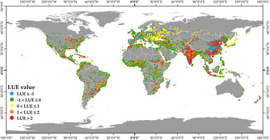
Principles and Applications of the Global Human Settlement Layer as Baseline for the Land Use Efficiency Indicator—SDG 11.3.1
Abstract
1. Introduction
2. Materials and Methods
2.1. The Global Human Settlement Layer Principles
- enhanced semantic interoperability and robustness against multi-stakeholder international information decision support scenarios, and
- effectiveness in time-critical image-derived analytics requirements that are set by crisis management applications.
- operates in an open and free data and methods access policy (open input, open method, open output),
- facilitates reproducible, scientifically defendable, fine-scale, synoptic, complete, planetary-size, and cost-effective information production, and
- facilitates information sharing and multilateral democratization of the information production and collective knowledge building.
2.2. The GHSL Data Layers
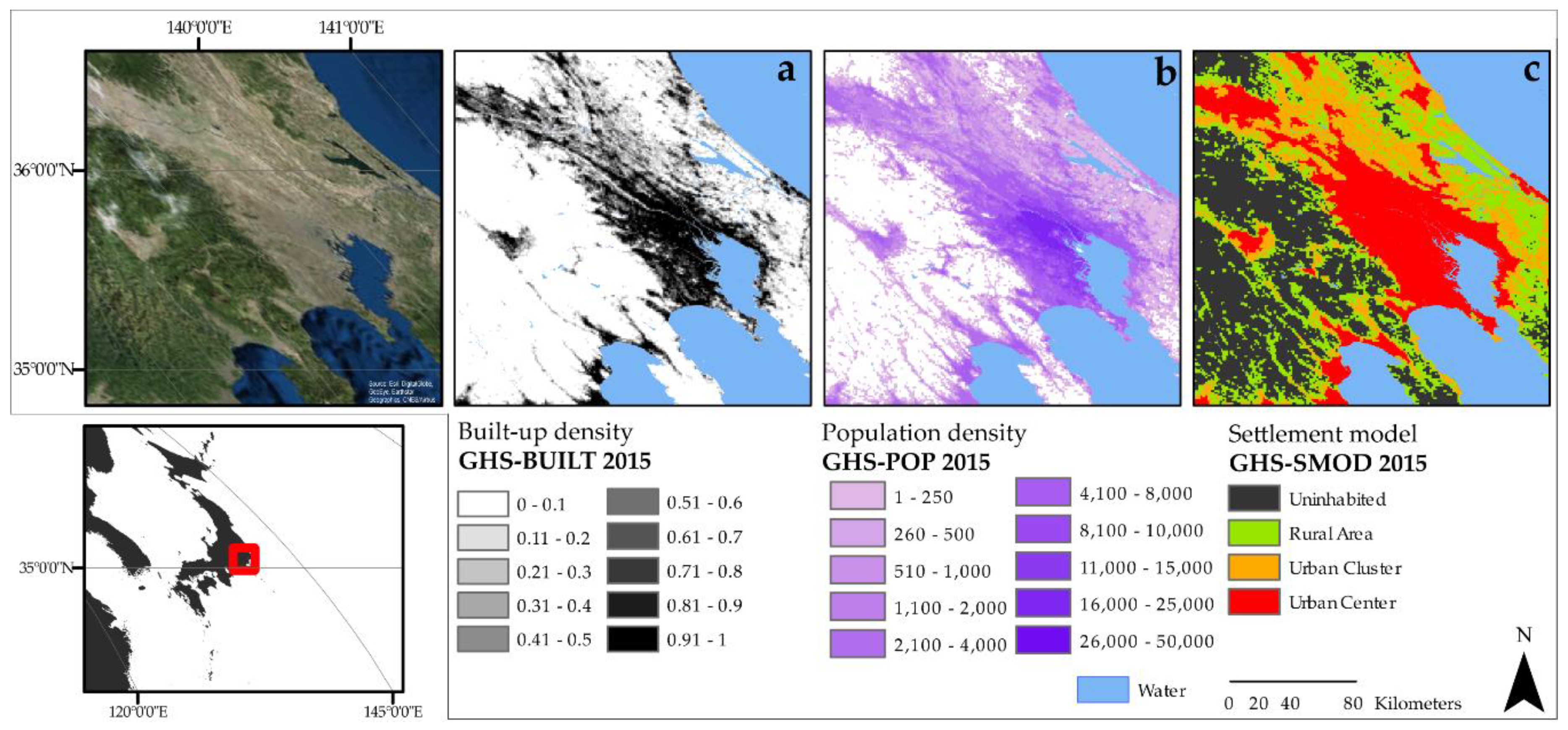
- at 250 m resolution in which values are expressed as decimals from 0 to 1 (density);
- at 1 km resolution in which values are expressed as decimals from 0 to 1 (density); and,
- at 30 m resolution in Spherical Mercator (EPSG: 3857), a multi-temporal layer where the presence of built-up areas per epoch is classified in numbers ranging from 6 (built-up area mapped 1975) to 3 (built-up area mapped in 2015), with additional classes for the non-built-up land (2), presence of water (1), and no data (0).
- at 250 m resolution; and,
- at 1 km resolution.
Multi-Temporal and Spatial Harmonization of Information
2.3. SDG 11.3.1 Methodology
2.4. Estimation of SDG 11.3.1 Using GHSL Baseline Data
- GHS-SMOD is used to delineate the extent of cities worldwide, defined as the areas classified as urban centers in the GHS-SMOD in the 2015 layer,
- for each of the spatially delineated city boundaries, GHS-BUILT for the epochs of 1990 and 2015 are used to assess the land consumption (LCR) over a period of 25 years, and
- for each of the spatially delineated city boundaries, GHS-POP for the epochs 1990 and 2015 are used to derive the PGR over a period of 25 years.
3. Results
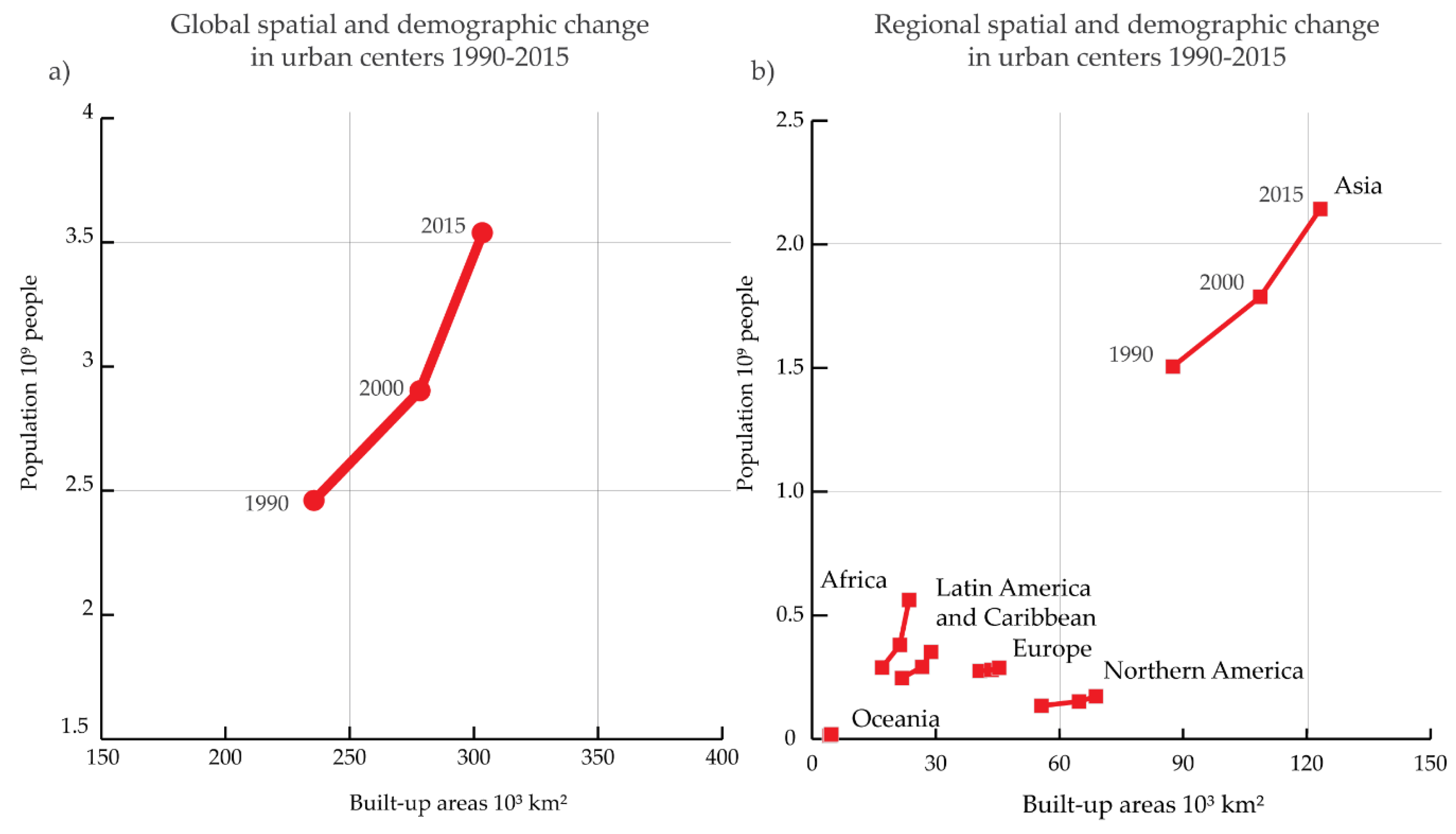
3.1. Spatial Expansion and Demographic Growth in Urban Centers
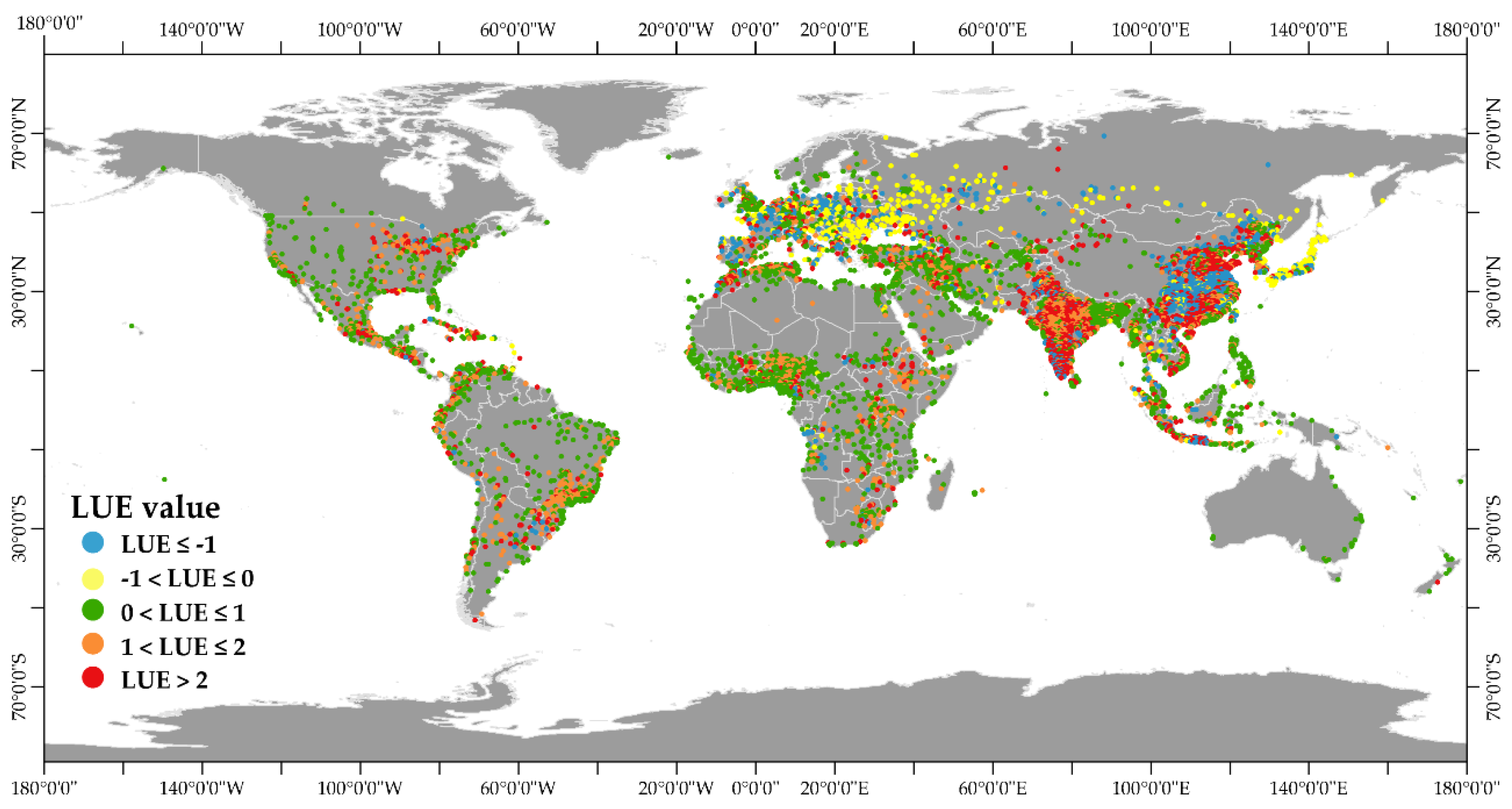
3.2. LUE in 10,000 Urban Centers
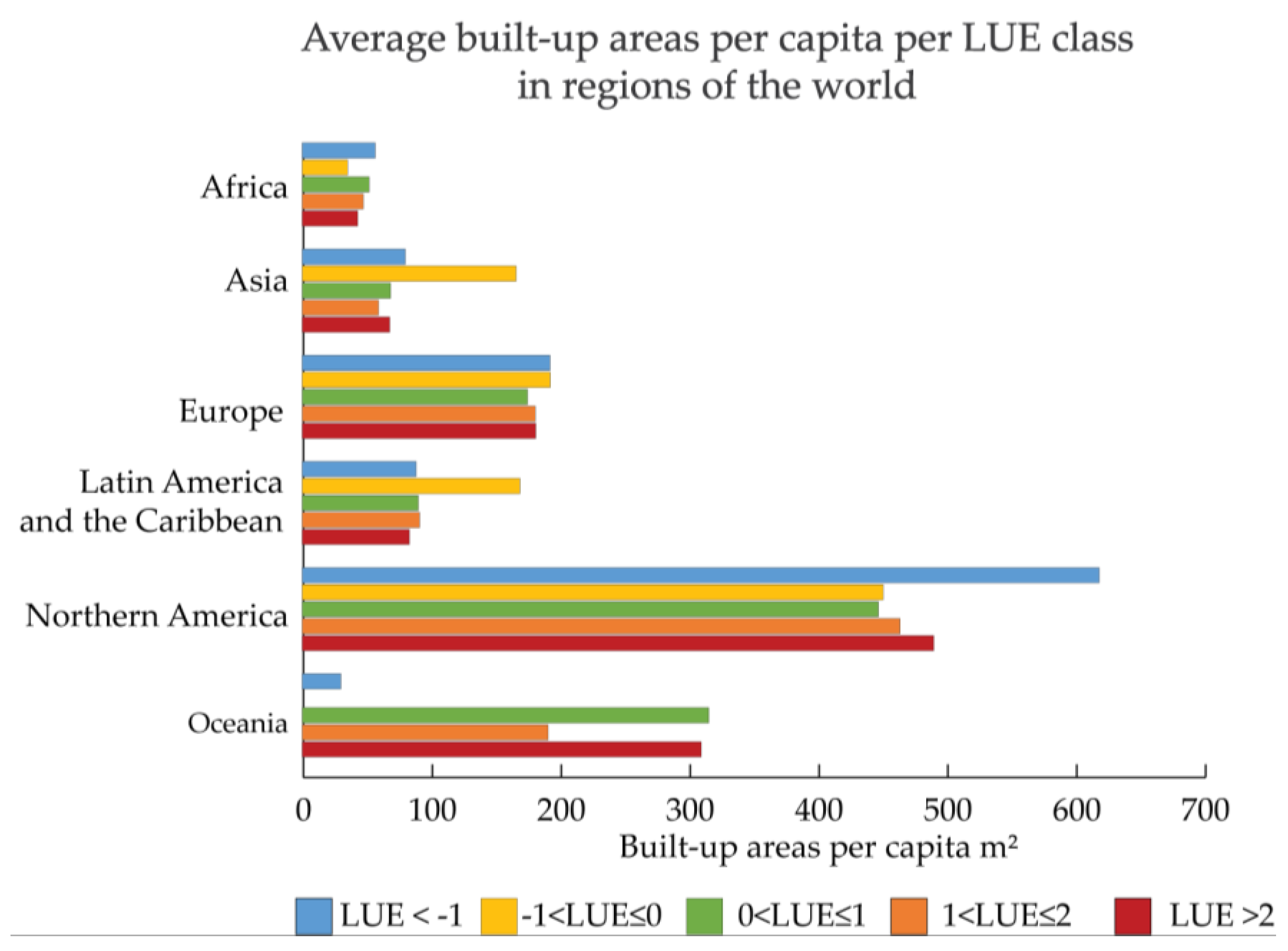
3.3. Built-Up Areas per Capita and Land Use Efficiency
4. Discussion
4.1. Open Data and Tools Filling Gaps of a Tier II Indicator
- global geographical coverage;
- multi-temporal (diachronic) information;
- demographic and spatial (built-up areas) information;
- open and free data; and,
- capacity to adapt to user requirements and hierarchical abstraction concepts.
- The definition of land consumption according to the GHSL data: in the GHSL concept and datasets, built-up areas that correspond to all man-made roofed constructions are used as proxies to Land Consumption. The latter, according to the UN definition, may be extended to cover other man-made features, such as roads, parking lots, or other artificial and impervious surfaces (and more closely align to SDG15.3.1);
- despite the use of increased spatial resolutions for built-up areas detection (as compared to precedent EO derived urban maps), some settlements can still be omitted due to their size or construction materials and some false detections may still be observed, especially over rocky bare lands; and,
- moreover, because the method for mapping built-up areas is based on physically observable built-up structures, as collected from satellite-borne sensors, some settlements could not be detected. Examples of invisible settlements as from the satellite remote sensing sensors that were adopted in this study include: small built-up structures below dense tree canopy, settlements carved in rock cliffs or underground, scattered huts in rural areas built with traditional materials, such as straw or clay (not distinguishable from the background soil and vegetation patterns), and some temporary settlements, such as tent refugee camps.
4.2. EO Derived Information on Human Settlements
5. Conclusions
Author Contributions
Funding
Acknowledgments
Conflicts of Interest
References
- United Nations General Assembly. Transforming Our World: The 2030 Agenda for Sustainable Development A/RES/70/1; United Nations: New York, NY, USA, 2015. [Google Scholar]
- Data for Development a Needs Assessment for SDG Monitoring and Statistical Capacity Development; United Nations Sustainable Development Solutions Network: Paris, France; New York, NY, USA, 2015.
- Work of the Statistical Commission Pertaining to the 2030 Agenda for Sustainable Development A/RES/71/313; United Nations General Assembly: New York, NY, USA, 2017.
- United Nations Statistical Commission. Contribution to the 2018 HLPF—United Nations Statistical Commission; United Nations Statistical Commission: New York, NY, USA, 2018. [Google Scholar]
- Anderson, K.; Ryan, B.; Sonntag, W.; Kavvada, A.; Friedl, L. Earth observation in service of the 2030 Agenda for Sustainable Development. Geo-Spat. Inf. Sci. 2017, 20, 77–96. [Google Scholar] [CrossRef]
- Paganini, M.; Petiteville, I. Satellite Earth Observations in Support of the Sustainable Development Goals, Special 2018 ed.; CEOS-ESA: Paris, France, 2018. [Google Scholar]
- UN Secretary-General’s Independent Expert and Advisory Group on the Data Revolution for Sustainable Development. A World that Counts Mobilising the Data Revolution for Sustainable Development; United Nations: New York, NY, USA, 2014. [Google Scholar]
- UNDESA. World Urbanization Prospects the 2007 Revision; United Nations: New York, NY, USA, 2008. [Google Scholar]
- Wirth, L. Urbanism as a Way of Life. Am. J. Sociol. 1938, 44, 1–24. [Google Scholar] [CrossRef]
- Donaldson, D.; Storeygard, A. The View from Above: Applications of Satellite Data in Economics. J. Econ. Perspect. 2016, 30, 171–198. [Google Scholar] [CrossRef]
- Zell, E.; Huff, A.K.; Carpenter, A.T.; Friedl, L.A. A User-Driven Approach to Determining Critical Earth Observation Priorities for Societal Benefit. IEEE J. Sel. Top. Appl. Earth Obs. Remote Sens. 2012, 5, 1594–1602. [Google Scholar] [CrossRef]
- Earth Observations in Supports of the 2030 Agenda for Sustainable Development; Japan Aerospace Exploration Agency: Tokyo, Japan, 2017.
- Noort, M. Earth Observation and Sustainable Development Goals in the Netherlands towards More Synergetic Use of Earth Observation: An exploratory Study; Ministry of Foreign Affairs of the Netherlands: The Hague, The Netherlands, 2017.
- Chrysoulakis, N.; Feigenwinter, C.; Triantakonstantis, D.; Penyevskiy, I.; Tal, A.; Parlow, E.; Fleishman, G.; Düzgün, S.; Esch, T.; Marconcini, M. A Conceptual List of Indicators for Urban Planning and Management Based on Earth Observation. ISPRS Int. J. Geo-Inf. 2014, 3, 980–1002. [Google Scholar] [CrossRef]
- Chmutina, K.; Bosher, L. Rapid Urbanisation and Security: Holistic Approach to Enhancing Security of Urban Spaces. In The Palgrave Handbook of Security, Risk and Intelligence; Dover, R., Dylan, H., Goodman, M.S., Eds.; Palgrave Macmillan: London, UK, 2017; pp. 27–45. [Google Scholar]
- Melchiorri, M.; Florczyk, A.; Freire, S.; Schiavina, M.; Pesaresi, M.; Kemper, T. Unveiling 25 Years of Planetary Urbanization with Remote Sensing: Perspectives from the Global Human Settlement Layer. Remote Sens. 2018, 10, 768. [Google Scholar] [CrossRef]
- Smith, D.A. Visualising world population density as an interactive multi-scale map using the global human settlement population layer. J. Maps 2017, 13, 117–123. [Google Scholar] [CrossRef]
- Pesaresi, M.; Melchiorri, M.; Siragusa, A.; Kemper, T. Atlas of the Human Planet 2016. Mapping Human Presence on Earth with the Global Human Settlement Layer; EUR 28116 EN; Publications Office of the European Union: Luxembourg, 2016. [Google Scholar]
- Ehrlich, D.; Melchiorri, M.; Florczyk, A.J.; Pesaresi, M.; Kemper, T.; Corbane, C.; Freire, S.; Schiavina, M.; Siragusa, A. Remote Sensing Derived Built-Up Area and Population Density to Quantify Global Exposure to Five Natural Hazards over Time. Remote Sens. 2018, 10, 1378. [Google Scholar] [CrossRef]
- Halkia, S.; Buda, D.; European Commission, Joint Research Centre, and Institute for the Protection and the Security of the Citizen. Information Support for Effective and Rapid External Action (ISFEREA) Support to External Security Unit; Publications Office of the European Union: Luxembourg, 2007. [Google Scholar]
- Jasani, B.; Pesaresi, M.; Schneiderbauer, S.; Zeug, G. (Eds.) Remote Sensing from Space—Supporting International Peace and Security; Springer: Berlin/Heidelberg, Germany, 2009. [Google Scholar]
- Pesaresi, M.; Ehrlich, D.; Ferri, S.; Florczyk, A.; Freire, S.; Haag, F.; Halkia, M.; Julea, A.M.; Kemper, T.; Soille, P. Global Human Settlement Analysis for Disaster Risk Reduction. Int. Arch. Photogramm. Remote Sens. Spat. Inf. Sci. 2015, 40, 837–843. [Google Scholar] [CrossRef]
- Corbane, C.; Kemper, T.; Freire, S.; Louvrier, C.; Pesarasi, M. Monitoring the Syrian Humanitarian Crisis with the JRC’s Global Human Settlement Layer and Night-Time Satellite Data; Publications Office of the European Union: Luxembourg, 2016. [Google Scholar]
- Pesaresi, M.; Ehrlich, D. A methodology to quantify built-up structures from optical {VHR} imagery. In Global Mapping of Human Settlement Experiences, Datasets, and Prospects; Gamba, P., Herold, M., Eds.; CRC Press: Boca Raton, FL, USA, 2009; pp. 27–58. [Google Scholar]
- Pesaresi, M.; Huadong, G.; Blaes, X.; Ehrlich, D.; Ferri, S.; Gueguen, L.; Halkia, M.; Kauffmann, M.; Kemper, T.; Lu, L.; et al. A Global Human Settlement Layer from Optical HR/VHR RS Data: Concept and First Results. IEEE J. Sel. Top. Appl. Earth Obs. Remote Sens. 2013, 6, 2102–2131. [Google Scholar] [CrossRef]
- Baumann, P.; Mazzetti, P.; Ungar, J.; Barbera, R.; Barboni, D.; Beccati, A.; Bigagli, L.; Boldrini, E.; Bruno, R.; Calanducci, A.; et al. Big data analytics for Earth Sciences: The EarthServer approach. Int. J. Digit. Earth 2016, 9, 3–29. [Google Scholar] [CrossRef]
- Nativi, S.; Mazzetti, P.; Santoro, M.; Papeschi, F.; Craglia, M.; Ochiai, O. Big Data challenges in building the Global Earth Observation System of Systems. Environ. Model. Softw. 2015, 68, 1–26. [Google Scholar] [CrossRef]
- Guo, H. Big Earth data: A new frontier in Earth and information sciences. Big Earth Data 2017, 1, 4–20. [Google Scholar] [CrossRef]
- Pesaresi, M. Global Fine-Scale Information Layers: The Need of a Paradigm Shift. In Proceedings of the Conference on Big Data from Space (BiDS’14), ESA-ESRIN, Frascati, Italy, 12–14 November 2014; Volume EUR 26868 EN, pp. 8–11. [Google Scholar]
- Florczyk, A.J.; Ferri, S.; Syrris, V.; Kemper, T.; Halkia, M.; Soille, P.; Pesaresi, M. A New European Settlement Map from Optical Remotely Sensed Data. IEEE J. Sel. Top. Appl. Earth Obs. Remote Sens. 2016, 9, 1978–1992. [Google Scholar]
- Doldirina, C. Open Data and Earth Observations: The Case of Opening Up Access to and Use of Earth Observation Data Through the Global Earth Observation System of Systems. J. Intellect. Prop. Inf. Tech. E-Commer. Law 2015, 6, 73–85. [Google Scholar]
- Demchenko, Y.; de Laat, C.; Membrey, P. Defining architecture components of the Big Data Ecosystem. In Proceedings of the 2014 International Conference on Collaboration Technologies and Systems (CTS), Minneapolis, MN, USA, 19–23 May 2014; pp. 104–112. [Google Scholar]
- Pesaresi, M.; Syrris, V.; Julea, A. A New Method for Earth Observation Data Analytics Based on Symbolic Machine Learning. Remote Sens. 2016, 8, 399. [Google Scholar] [CrossRef]
- Mayer-Schönberger, V.; Cukier, K. Big Data: A Revolution That Will Transform How We Live, Work, and Think; Houghton Mifflin Harcourt: Boston, MA, USA, 2013. [Google Scholar]
- Pesaresi, M.; Syrris, V.; Julea, A. Benchmarking of the Symbolic Machine Learning Classifier with State of the Art Image Classification Methods—Application to Remote Sensing Imagery; JRC Technical Report EUR 27518; Publications Office of the European Union: Luxembourg, 2015. [Google Scholar]
- Yang, H.; Li, S.; Chen, J.; Zhang, X.; Xu, S. The Standardization and Harmonization of Land Cover Classification Systems towards Harmonized Datasets: A Review. ISPRS Int. J. Geo-Inf. 2017, 6, 154. [Google Scholar] [CrossRef]
- Taylor, B.; Kuyatt, C. Guidelines for Evaluating and Expressing the Uncertainty of NIST Measurement Results; National Institute for Standards and Technology: Gaithersburg, MD, USA, 2007.
- Ho, T.K. Random decision forests. In Proceedings of the 3rd International Conference on Document Analysis and Recognition, Montreal, QC, Canada, 14–16 August 1995; Volume 1, pp. 278–282. [Google Scholar]
- Zhong, S.; Liu, Y.; Liu, Y. Bilinear deep learning for image classification. In Proceedings of the 19th ACM international conference on Multimedia—MM’11, Scottsdale, AZ, USA, 28 November–1 December 2011; p. 343. [Google Scholar]
- Colclough, C. Ethical artificial intelligence—10 Essential ingredients. Available online: https://www.oecd-forum.org/users/75928-dr-christina-j-colclough/posts/29527-10-principles-for-ethical-artificial-intelligence (accessed on 16 February 2019).
- JRC. GHS BUILT-UP Grid, Multitemporal 1975-1990-2000-2015; JRC Data Catalogue; European Commission, Joint Research Centre: Brussels, Belgium, 2015. [Google Scholar]
- Gutman, G.; Huang, C.; Chander, G.; Noojipady, P.; Masek, J. Assessment of the NASA-USGS Global Land Survey (GLS) datasets. Remote Sens. Environ. 2013, 134, 249–265. [Google Scholar] [CrossRef]
- Pesaresi, M.; Ehrlich, D.; Ferri, S.; Florczyk, A.; Freire, S.; Halkia, M.; Julea, A.; Kemper, T.; Soille, P.; Syrris, V. Operating Procedure for the Production of the Global Human Settlement Layer from Landsat Data of the Epochs 1975, 1990, 2000, and 2014; JRC Technical Report EUR 27741 EN; Publications Office of the European Union: Ispra, Italy, 2016. [Google Scholar]
- Arino, O.; Perez, J.J.R.; Kalogirou, V.; Bontemps, S.; Defourny, P.; van Bogaert, E. Global Land Cover Map for 2009 (GlobCover 2009); PANGAEA—Data Publisher for Earth Environmental Science, 2012. Available online: https://doi.pangaea.de/10.1594/PANGAEA.787668 (accessed on 16 February 2019).
- Bhaduri, B.; Bright, E.; Coleman, P.; Dobson, J. LandScan: Locating people is what matters. Geoinformatics 2002, 5, 34–37. [Google Scholar]
- Schneider, A.; Friedl, M.A.; Potere, D. A new map of global urban extent from MODIS satellite data. Environ. Res. Lett. 2009, 4, 044003. [Google Scholar] [CrossRef]
- JRC; CIESIN. GHS Population Grid, Derived from GPW4, Multi-Temporal (1975, 1990, 2000, 2015); JRC Data Catalogue; European Commission, Joint Research Centre: Brussels, Belgium, 2015. [Google Scholar]
- JRC. GHS Settlement Grid Multi-Temporal (1975, 1990, 2000, 2014); Joint Research Centre: Brussels, Belgium, 2015. [Google Scholar]
- Dijkstra, L.; Poelman, H. A Harmonised Definition of Cities and Rural Areas: The New Degree of Urbanization; Publications Office of the European Union: Luxembourg, 2014. [Google Scholar]
- Pesaresi, M.; Freire, S. GHS Settlement Grid Following the REGIO Model 2014 in Application to GHSL Landsat and CIESIN GPW v4-Multitemporal (1975-1990-2000-2015); JRC Data Catalogue; European Commission, Joint Research Centre: Brussels, Belgium, 2016. [Google Scholar]
- Florczyk, A.; Ehrlich, D.; Corbane, C.; Freire, S.; Kemper, T.; Melchiorri, M.; Pesaresi, M.; Politis, P.; Schiavina, M.; Zanchetta, L. Community pre-Release of GHS Data Package (GHS CR2018) in support to the GEO Human Planet Initiative Version 1.0; Publications Office of the European Union: Luxembourg, 2018. [Google Scholar]
- Freire, S.; Florczyk, A.; Ehrlich, D.; Pesaresi, M. Remote sensing derived continental high resolution built-up and population geoinformation for crisis management. In Proceedings of the 2015 IEEE International Geoscience and Remote Sensing Symposium (IGARSS), Milan, Italy, 26–31 July 2015; pp. 2677–2679. [Google Scholar]
- Florczyk, A.; Andredakis, I.; Freire, S.; Ferri, S.; Pesaresi, M. Remote Sensing datasets supporting disaster alert systems on multiscale via Web services. In Proceedings of the 2015 IEEE International Geoscience and Remote Sensing Symposium (IGARSS), Milan, Italy, 26–31 July 2015. [Google Scholar]
- Ferrer, M.M.; Vernaccini, L.; Poljansek, K. Index for Risk Management—INFORM. Concept and Methodology Version 2017; EUR 28655 EN; Publications Office of the European Union: Luxembourg, 2017. [Google Scholar]
- Moran, D.; Kanemoto, K.; Jiborn, M.; Wood, R.; Többen, J.; Seto, K.C. Carbon footprints of 13 000 cities. Environ. Res. Lett. 2018, 13, 064041. [Google Scholar] [CrossRef]
- Weiss, D.J.; Nelson, A.; Gibson, H.S.; Temperley, W.; Peedell, S.; Lieber, A.; Hancher, M.; Poyart, E.; Belchior, S.; Fullman, N.; et al. A global map of travel time to cities to assess inequalities in accessibility in 2015. Nature 2018, 553, 333–336. [Google Scholar] [CrossRef]
- Cherlet, M.; Hutchinson, C.; Reynolds, J.; Hill, J.; Sommer, S.; von Maltitz, G. World Atlas of Desertification; Publications Office of the European Union: Luxembourg, 2018. [Google Scholar]
- JRC. GHSL Data Packages Instructions for Data Access. V1.0; Joint Research Centre: Brussels, Belgium, 2016. [Google Scholar]
- Center for International Earth Science Information Network-CIESIN-Columbia University. Gridded Population of the World, Version 4 (GPWv4): Population Density; NASA Socioeconomic Data and Applications Center (SEDAC): Palisades, NY, USA, 2016.
- Schneider, A.; Woodcock, C.E. Compact, Dispersed, Fragmented, Extensive? A Comparison of Urban Growth in Twenty-five Global Cities using Remotely Sensed Data, Pattern Metrics and Census Information. Urban Stud. 2008, 45, 659–692. [Google Scholar] [CrossRef]
- Venables, A.J. Breaking into tradables: Urban form and urban function in a developing city. J. Urban Econ. 2017, 98, 88–97. [Google Scholar] [CrossRef]
- United Nations, Department of Economic and Social Affairs, Population Division. World Urbanization Prospects: The 2018 Revision; United Nations: New York, NY, USA, 2018. [Google Scholar]
- Corbane, C.; Politis, P.; Pesaresi, M.; Kemper, T.; Siragusa, A. Estimation of Land Use Efficiency from the Global Human Settlement Layer (GHSL). In QGIS and Applications in Territorial Planning; Baghdadi, N., Mallet, C., Zribi, M., Eds.; John Wiley Sons, Inc.: Hoboken, NJ, USA, 2018; pp. 39–52. [Google Scholar]
- Pesaresi, M.; Corbane, C.; Julea, A.; Florczyk, A.J.; Syrris, V.; Soille, P. Assessment of the Added-Value of Sentinel-2 for Detecting Built-up Areas. Remote Sens. 2016, 8, 299. [Google Scholar] [CrossRef]
- Corbane, C.; Lemoine, G.; Pesaresi, M.; Kemper, T.; Sabo, F.; Ferri, S.; Syrris, V. Enhanced automatic detection of human settlements using Sentinel-1 interferometric coherence. Int. J. Remote Sens. 2018, 39, 842–853. [Google Scholar] [CrossRef]
- Dou, Y.; Liu, Z.; He, C.; Yue, H. Urban Land Extraction Using VIIRS Nighttime Light Data: An Evaluation of Three Popular Methods. Remote Sens. 2017, 9, 175. [Google Scholar] [CrossRef]
- Angel, S.; Blei, A.M.; Civco, D.M.; Lamson-Hall, P.; Parent, J.; Sanchez, N.G.; Thom, K. Atlas of Urban Expansion, 2015 ed.; The NYU Urbanization Project: New York, NY, USA; The Lincoln Institute of Land Policy: Cambridge MA, USA; UN Habitat: Nairobi, Kenya, 2015. [Google Scholar]
- Leyk, S.; Uhl, J.H.; Balk, D.; Jones, B. Assessing the accuracy of multi-temporal built-up land layers across rural-urban trajectories in the United States. Remote Sens. Environ. 2018, 204, 898–917. [Google Scholar] [CrossRef]
- Klotz, M.; Kemper, T.; Geiß, C.; Esch, T.; Taubenböck, H. Mapping spatial settlement patterns on a global scale: Multi-scale cross-comparison of new and existing global urban maps. Remote Sens. Environ. 2015, 178, 191–212. [Google Scholar] [CrossRef]
- Freire, S.; Doxsey-Whitfield, E.; MacManus, K.; Mills, J.; Pesaresi, M. Development of new open and free multi-temporal global population grids at 250 m resolution. In Proceedings of the AGILE 2016, Helsinki, Finland, 14–17 June 2016. [Google Scholar]
- Esch, T.; Heldens, W.; Hirner, A. The Global Urban Footprint. In Urban Remote Sensing, 2nd ed.; CRC Press: Boca Raton, FL, USA, 2018; pp. 3–14. [Google Scholar]
- Weng, Q.; Quattrochi, D.A.; Gamba, P. (Eds.) Urban Remote Sensing, 2nd ed.; CRC Press: Boca Raton, FL, USA, 2018. [Google Scholar]
- Yuan, J.; Chowdhury, P.K.R.; McKee, J.; Yang, H.L.; Weaver, J.; Bhaduri, B. Exploiting deep learning and volunteered geographic information for mapping buildings in Kano, Nigeria. Sci. Data 2018, 5, 180217. [Google Scholar] [CrossRef]
- OECD. Compact City Policies; OECD Publishing: Paris, France, 2012. [Google Scholar]
- World Cities Report 2016 Urbanization and Development: Emerging Futures; United Nations Human Settlements Programme (UN-Habitat): Nairobi, Kenya, 2016; Volume HS/005/17E.
| Name | Semantic | Grid Resolution | Epoch 1 | Main Input Data |
|---|---|---|---|---|
| GHS-BUILT | Density of built-up area per grid cell | 30 m, 250 m, 1 km | 2015, 2000, 1990, 1975 | Satellite imagery |
| GHS-POP | Population counts per grid cell | 250 m, 1 km | Census data, GHS-BUILT | |
| GHS-SMOD | Classification of each grid cell into one of the Settlement Model classes: high density cluster, low density cluster, and rural cells | 1-km | GHS-BUILT, GHS-POP |
© 2019 by the authors. Licensee MDPI, Basel, Switzerland. This article is an open access article distributed under the terms and conditions of the Creative Commons Attribution (CC BY) license (http://creativecommons.org/licenses/by/4.0/).
Share and Cite
Melchiorri, M.; Pesaresi, M.; Florczyk, A.J.; Corbane, C.; Kemper, T. Principles and Applications of the Global Human Settlement Layer as Baseline for the Land Use Efficiency Indicator—SDG 11.3.1. ISPRS Int. J. Geo-Inf. 2019, 8, 96. https://doi.org/10.3390/ijgi8020096
Melchiorri M, Pesaresi M, Florczyk AJ, Corbane C, Kemper T. Principles and Applications of the Global Human Settlement Layer as Baseline for the Land Use Efficiency Indicator—SDG 11.3.1. ISPRS International Journal of Geo-Information. 2019; 8(2):96. https://doi.org/10.3390/ijgi8020096
Chicago/Turabian StyleMelchiorri, Michele, Martino Pesaresi, Aneta J. Florczyk, Christina Corbane, and Thomas Kemper. 2019. "Principles and Applications of the Global Human Settlement Layer as Baseline for the Land Use Efficiency Indicator—SDG 11.3.1" ISPRS International Journal of Geo-Information 8, no. 2: 96. https://doi.org/10.3390/ijgi8020096
APA StyleMelchiorri, M., Pesaresi, M., Florczyk, A. J., Corbane, C., & Kemper, T. (2019). Principles and Applications of the Global Human Settlement Layer as Baseline for the Land Use Efficiency Indicator—SDG 11.3.1. ISPRS International Journal of Geo-Information, 8(2), 96. https://doi.org/10.3390/ijgi8020096


