1. Introduction
Web text contains huge volumes of geographical knowledge that can help to improve the richness and freshness of geographical information. However, knowledge represented by natural language is difficult for computers to understand. Knowledge graphs (KGs) [
1] are introduced to organize the knowledge of natural language descriptions in a way that can be processed by computers. KGs link the semantic content of entities into a network, namely Semantic Web [
2], that facilitates knowledge interoperability. This semantic content describes the entity’s attributes in the form of the object–attribute–value triple [
3], commonly written as A (
O,
V). That is, an object
O has an attribute
A with the value
V. The attribute can express a relationship when the value is also an object.
Relation extraction (RE) is a primary work of KG construction. With breakthroughs in natural language processing technologies, many RE systems have been developed and are publicly available, for example: Reverb [
4], ClausIE [
5], OLLIE [
6], Stanford OpenIE [
7], OpenIE4 [
8], and OpenIE5 [
9]. These RE systems make it easier to identify relations between geo-entities from web text. However, web text is noisy and geographical knowledge in web text is often relatively sparse, leading to low-quality geo-entity relations extracted by RE systems. Hence, quality assessment of geo-entity relations extracted from web text must be performed before they can be used. In fact, many of the relations extracted from web text are unknown or have changed, and a gold standard may be unavailable or may not even exist, which poses a significant challenge for the quality assessment of geo-entity relations.
We propose a knowledge-based method to filter geo-entity relations extracted from web text. Geo-related knowledge (the semantic links between geo-entity classes) is introduced to assess the extracted relations. To generate the geo-related knowledge, we take full advantage of ontology knowledge, fact knowledge, and synonym knowledge from common knowledge bases (KBs) [
10]. Moreover, we transfer the extracted geo-entity relations and geo-related knowledge into low-dimensional dense vectors, so as to calculate the maximum semantic similarity as the confidence value. Finally, credible geo-entity relations are filtered out if their confidence values are bigger than a given threshold. Experimental results show that the proposed method is effective for assessing the confidence level of geo-entity relations extracted from web text. To summarize, our main contributions are as follows:
- (1)
Propose a novel framework to automatically filter geo-entity relations. This framework provides a new way of identifying credible geographic information from web text according to human knowledge.
- (2)
Establish a credible KB of geo-entity relations (confidence value ≥ 0.7), which can be used to construct and complement a geographic knowledge graph.
3. Methodology
There are many open access KBs, such as Yago, DBpedia, and WordNet, that have been widely used for place name disambiguation [
19], semantic search [
20], knowledge discovery [
21], and so on. A well-known application of KBs is Watson [
22], a question-answering computer system that uses multiple information sources (including ontologies, encyclopedias, dictionaries, and other material) to build knowledge.
We use common KBs as the reference data to assess the credibility of geo-entity relations extracted from web text. These relations are described in natural language, and express position, topology, direction, distance, and other semantic information between two geo-entities. According to the formalisms used in the Semantic Web, we defined the relevant concepts as follows.
Geo-entity relation triple: <subjectgeo, relation, objectgeo>, abbreviated as <subgeo, rel, objgeo>. Similar to the triple A(O, V), rel expresses a relationship between its subject and object that are geo-entities.
Class pair of geo-entities: <class_subgeo, class_objgeo>; this describes the geographical categories to which the subject and object belong.
Relational indicator: Abbreviated as rel_ind. Similar to the object property defined by ontology, the relational indicator is a property whose subjects and objects must belong to the extension of pointed geographical categories. Each class pair of geo-entities corresponds to a set of relational indicators, written as <(class_subgeo, class_objgeo), set(rel_ind)>.
If the relation in the extracted triple is more semantically similar to one relational indicator, the extracted triple will probably be correct. The proposed method is divided into two steps, described as follows.
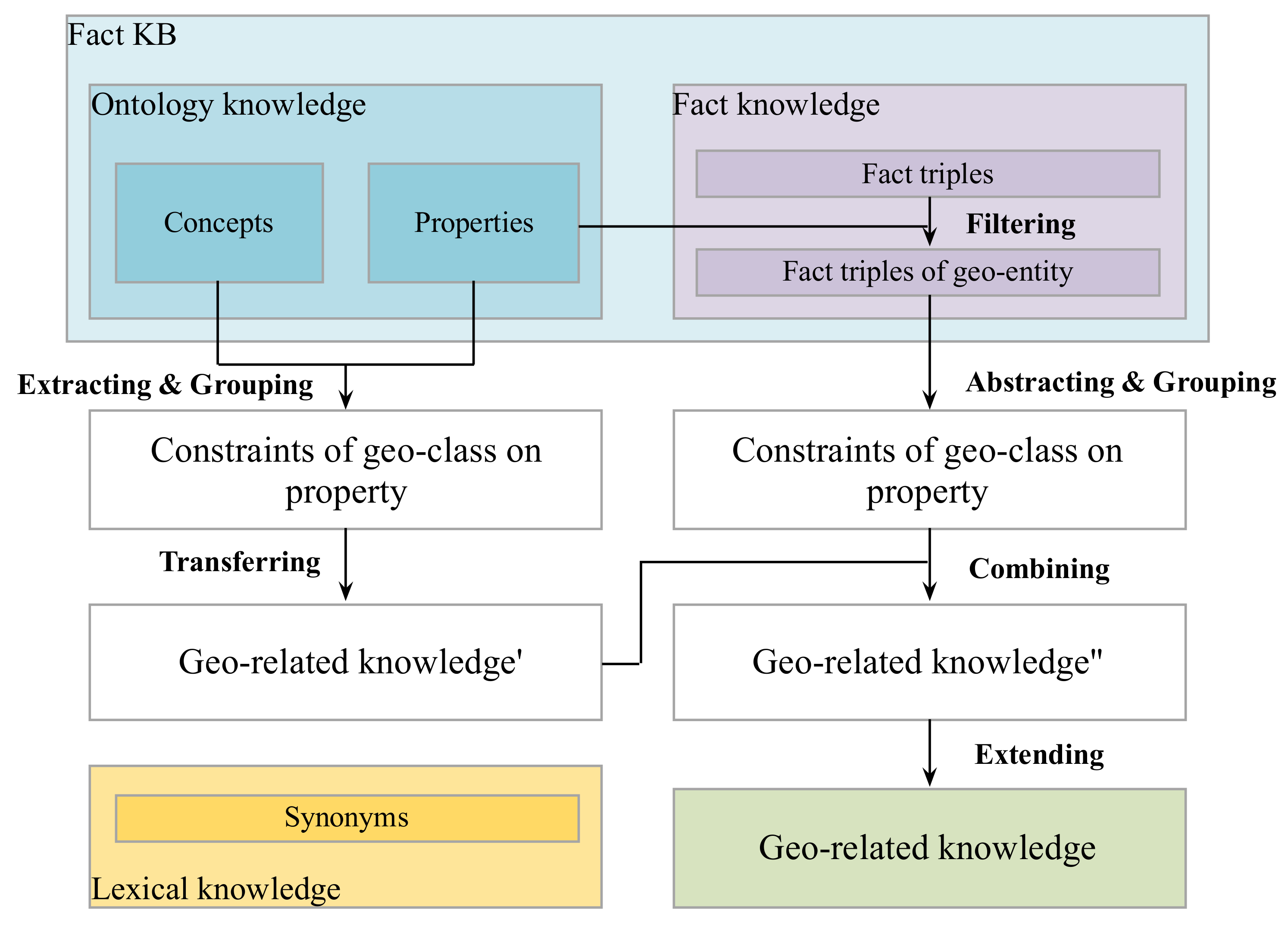
3.1. Acquiring Geo-Related Knowledge from KBs
This step aims to establish the mapping
<(
class_
subgeo, class_objgeo)
, set(
rel_ind)
>, namely geo-related knowledge.
Figure 1 shows the process of integrating three types of knowledge to generate geo-related knowledge.
Firstly, ontology well defines concepts and relationships in some communities [
3]. Properties represent relationships in ontology. If the subjects and objects of one property belong to geographical categories, this property is saved as the relational indicator. For instance, the class pair of geo-entities (
road, city) has the relational indicator “
beltway city” in DBpedia Ontology.
Secondly, fact triples of KBs characterize object attributes in the real world. The attributes in fact triples can complement relational indicators. For example, the relational indicators of (road, city) are extended to (beltway city, route junction) by using the fact triples of DBpedia. Besides, fact triples of KBs can supply additional class pairs of geo-entities that are missing in ontology. So, the attributes and categories in fact triples of KBs are added into the mapping <(class_subgeo, class_objgeo), set(rel_ind)>.
Thirdly, synonym KBs group words together based on their semantic similarities. In natural language text, there are limited vocabularies to describe direction and distance relationships; their relational indicators can be acquired by enumeration. However, the expressions of topological relations are much more complex and the used vocabularies are very different from domain definitions. By using the synonyms in WordNet (
http://wordnet.princeton.edu), we generate the relational indicators for eight topological relations (defined by Egenhofer [
23]: disjoint, meet, overlap, inside, contain, cover, coveredBy, equal). According to the topological constraints between different shapes of geo-entities, the relational indicators of (
road, city) are finally updated as (
beltway city, route junction, pass through, cross, enter, connect, in).
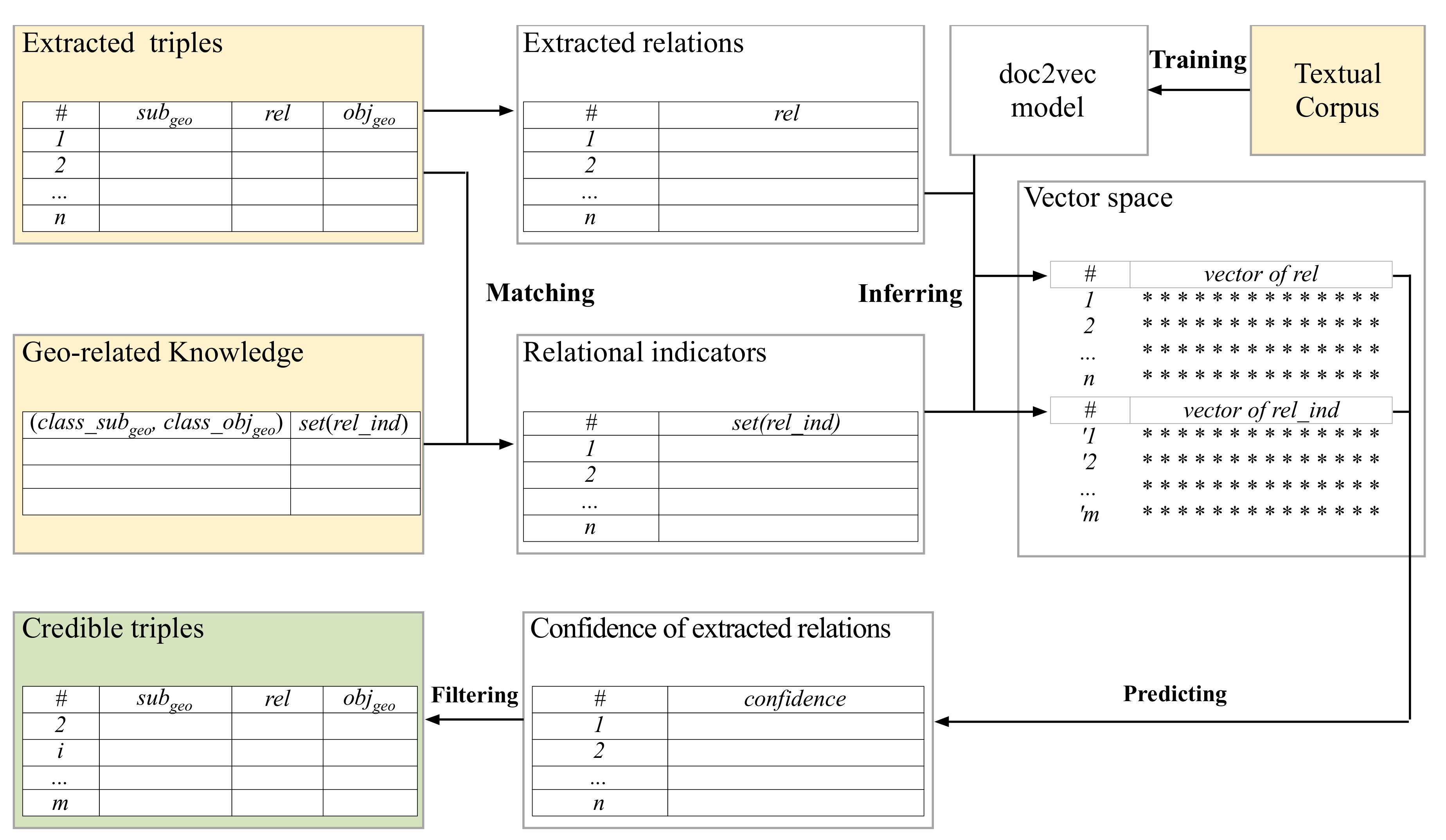
3.2. Predicting Confidence for Geo-Entity Relations
The confidence value of geo-entity relations can be predicted based on the similarities between the extracted relation and its relational indicators. Considering that a relation has different expressions in natural language text, which may not precisely match its relational indicators, we firstly project the relation and its relational indicators into a dense, low-dimensional vector space by a machine learning model, namely doc2vec [
24]. In this vector space, the semantic similarity of any two objects can be calculated based on the cosine distance or the Euclidean distance.
The flowchart of confidence prediction is shown in
Figure 2. First, for all of the relation triples extracted by the RE system, we only save the geo-related triples whose subjects and objects belong to geographical categories. Besides, we obtain the relational indicators according to the mapping
<(
class_
subgeo, class_objgeo)
, set(
rel_ind)
>. Second, we train the machine learning model ‘doc2vec’ (
https://github.com/inejc/paragraph-vectors) to transfer the extracted relations and the relational indicators into vectors. Third, for each geo-related triple, we calculate the similarity between the extracted relation and each of its relational indicators, and take the maximal similarity as the confidence value. Finally, the triple is considered a credible extraction if its confidence value is bigger than a given threshold, which is introduced in
Section 5.4.
The confidence function is defined as Formula (1). Here, Ct(subgeo, rel, objgeo) denotes the confidence value of the geo-entity relation triple, I is the set of the relational indicators for the class pair (class_subgeo, class_objgeo), i is a relational indicator in the set, erel is the vector representation of the relation rel, and ei is the vector representation of the relational indicator i.
4. Experiments
4.1. Data
In the experiment, DBpedia and WordNet were selected as the KBs, and Wikipedia articles were used as the corpus for extracting geo-entity relation triples and training the doc2vec model. The details are as follows:
- (1)
Fine-grained categories of geo-entities were extracted from DBpedia Ontology (261 in total). These contain organization (i.e., company, school, government agency, bank, etc.) and place (i.e., island, country, ocean, mountain, road, factory, hotel, etc.).
- (2)
Class pairs of geo-entities were extracted from the ontology and fact triples of DBpedia (1,159 in total).
- (3)
Relational indicators were acquired from the ontology and fact triples of DBpedia and WordNet (177 in total).
- (4)
English Wikipedia articles of geographical entries were used to extract geo-entity relation triples (2.8 GB in total). We generated 517,805 triples by inputting these articles into an RE system (Stanford OpenIE system,
https://nlp.stanford.edu/software/openie.html).
- (5)
All articles from English Wikipedia were used as a corpus to train the doc2vec model; the corpus size is 14.2 GB. Each vector has 100 dimensions.
As there is no gold standard for extracted triples, the correctness (right is 1 and wrong is 0) and the relational type (spatial or semantic) of partial triples were manually annotated in order to verify the effectiveness of the proposed method. First, we randomly arranged 517,805 triples by their confidence values and divided them into 10 equal sections, ensuring that each section had approximately the same number of triples. Second, 100 triples were randomly selected from each section, and in all, 1000 triples were annotated by two researchers in GIS major. Third, we re-divided the sampled triples according to their confidence values into the ranges of [0, 0.1), [0.1, 0.2), …, [0.8, 0.9), [0.9, 1]. Then, we computed the accuracy of each interval as the real probability of triple confidence.
4.2. Experimental Design
The extraction results of the three methods are compared (
Table 1). (1) StanOIE: The original Stanford OpenIE system, which outputs confidence for each extracted triple. (2) KNOWfact: The presented method whose geo-related knowledge is only obtained from ontology and fact triples of KBs. (3) KNOWfact+lex: The presented method extends the indicators of topological relations using synonym KBs. Moreover, we separate all samples into semantic relations (e.g., “sisterCollege”, “largestSettlement”) and spatial relations (e.g., “closeTo”, “riverBranchOf”), to test how relational indicators affect different relation types.
4.3. Metrics
Since the accuracy of confidence prediction decides the effect of geo-entity relation filtration, the introduced metrics focus on verifying the rationality of confidence prediction results. The mean square error (MSE), the curve of receiver operating characteristic (ROC), and the area under the ROC curve (AUC) are calculated.
- (1)
MSE: We measure MSE between the predicted confidence value and the real probability; the lower the better. As given in Formula (2), n is the triple number of each interval,
is the predicted confidence value, and
is the real probability of each interval.
- (2)
ROC and AUC: We order triples according to their confidence values, compute the true positive rate (TPR) and the false positive rate (FPR) according to Formulas (3) and (4) and the confusion matrix (
Table 2), and then plot the ROC curve, where the
x-axis represents the FPR and the
y-axis represents the TPR. If a method’s ROC is closer to the point (0,1), its performance is better. AUC computes the area under the ROC curve; the higher the better.
5. Results and Discussion
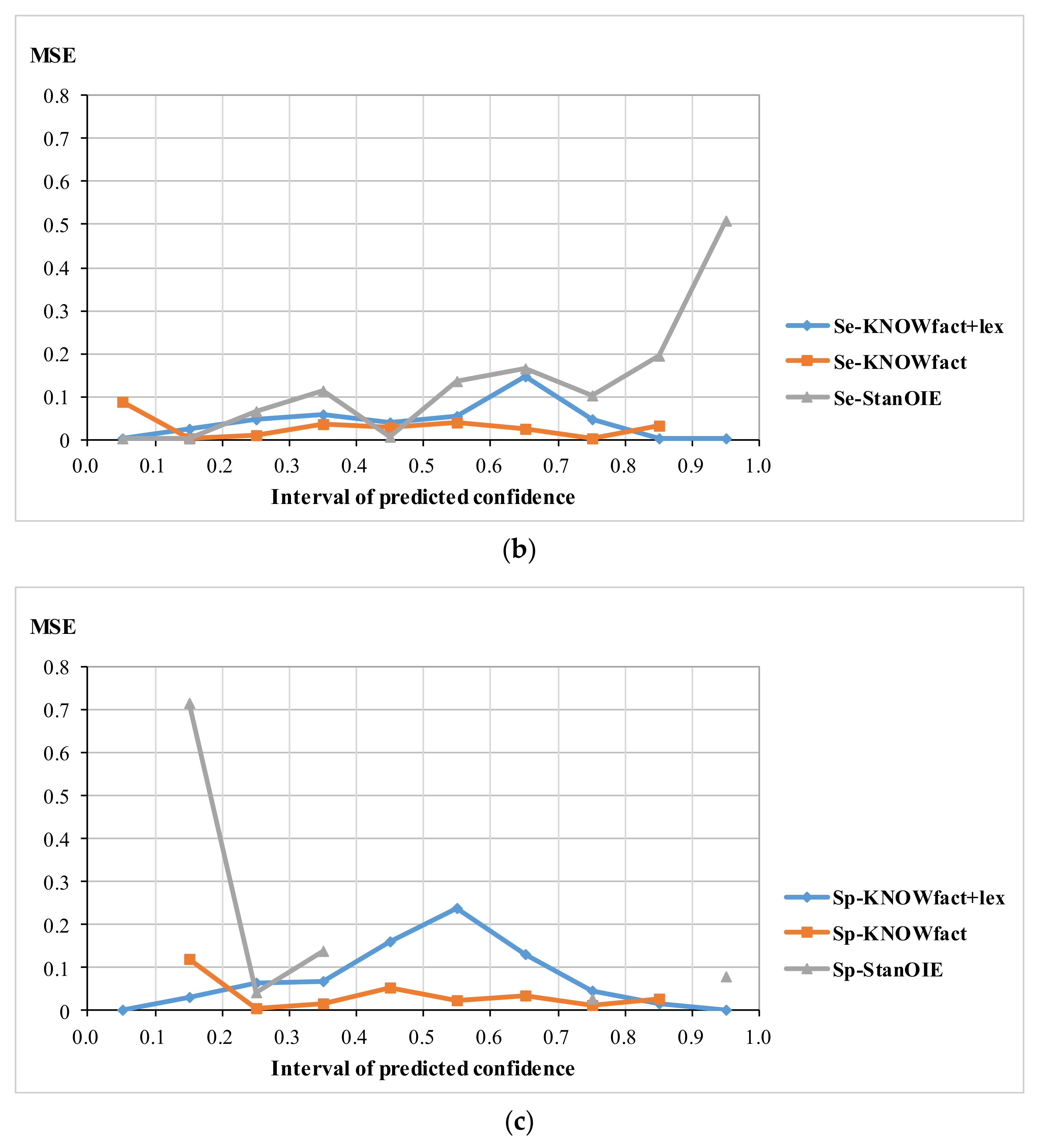
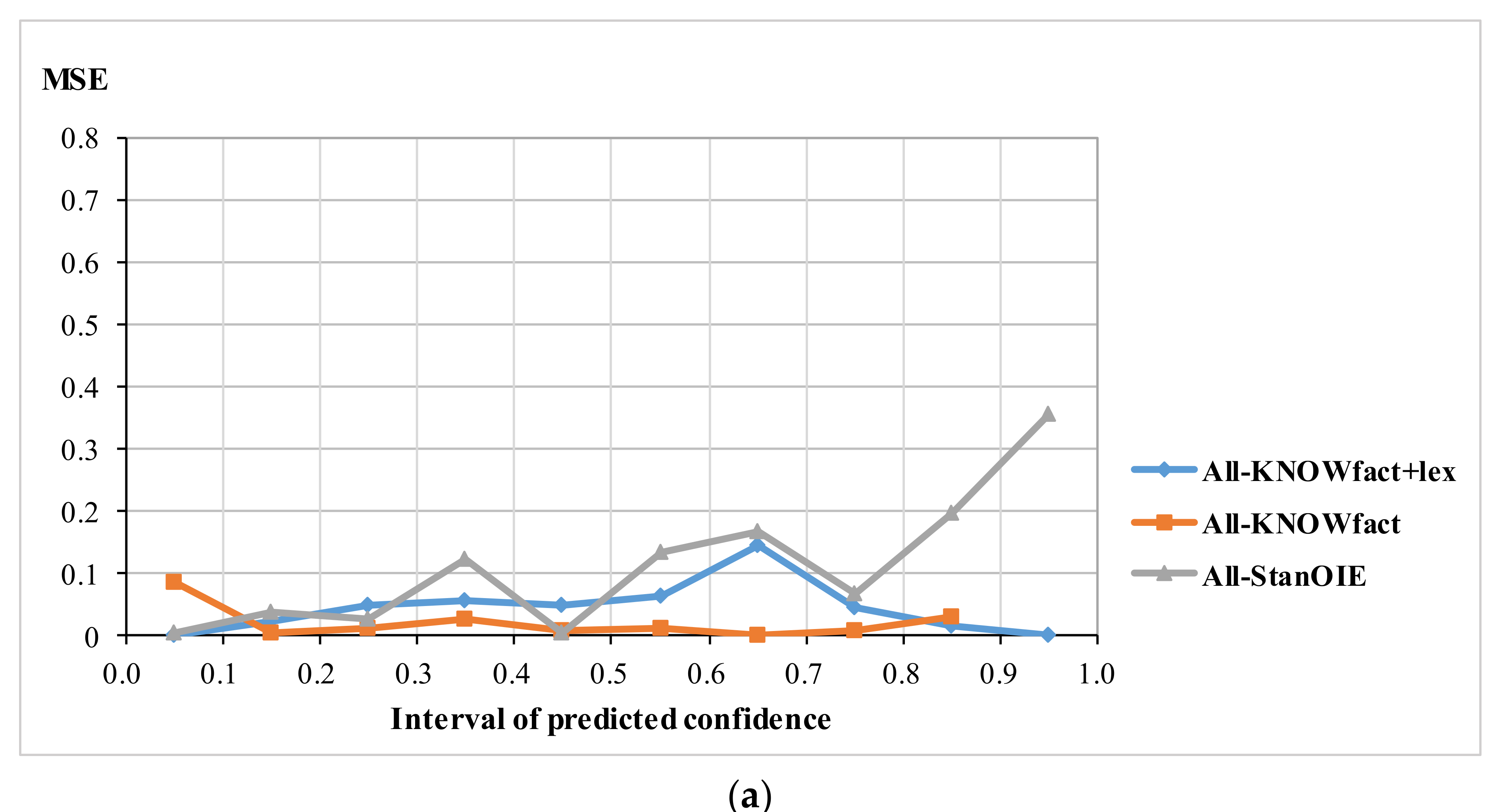
5.1. MSE
Figure 3 shows the MSE for all samples (
Figure 3a), for semantic relation samples (
Figure 3b), and for spatial relation samples (
Figure 3c), where the
x-axis represents the confidence interval and the
y-axis represents the MSE (note that the line of Sp-StanOIE is discontinuous in
Figure 3c, because no confidence predicted by Sp-StanOIE falls into some intervals).
For the three types of sample, KNOWfact+lex has a significant advantage with the lowest MSE in the range of [0, 0.2] and [0.8, 1]. This means that if the confidence value predicted by KNOWfact+lex falls in [0, 0.2], the triple is most likely a negative sample. Likewise, if the confidence value predicted by KNOWfact+lex falls in [0.8, 1], the triple is probably positive. This implies that fact and synonym knowledge are effective for distinguishing between right and wrong geo-related triples.
Stanford OpenIE (StanOIE) performs the worst for the three different types of sample. As shown
Figure 3a,b , it has a very high MSE for positive samples. This is because StanOIE assigns the confidence value 1.0 to 94.14% of samples (in fact, only 39.78% of samples in
Figure 3a and 28.52% of samples in
Figure 3b are positive samples), which leads to several false positive triples. For spatial relation samples (
Figure 3c), StanOIE performs well for positive samples but poorly for negative samples. This is because the number of the confidence value of 1.0 predicted by StanOIE is almost the total number of real positive samples, but a confidence value of 0.0 is only assigned to 1% of negative samples, leading to a low true negative rate.
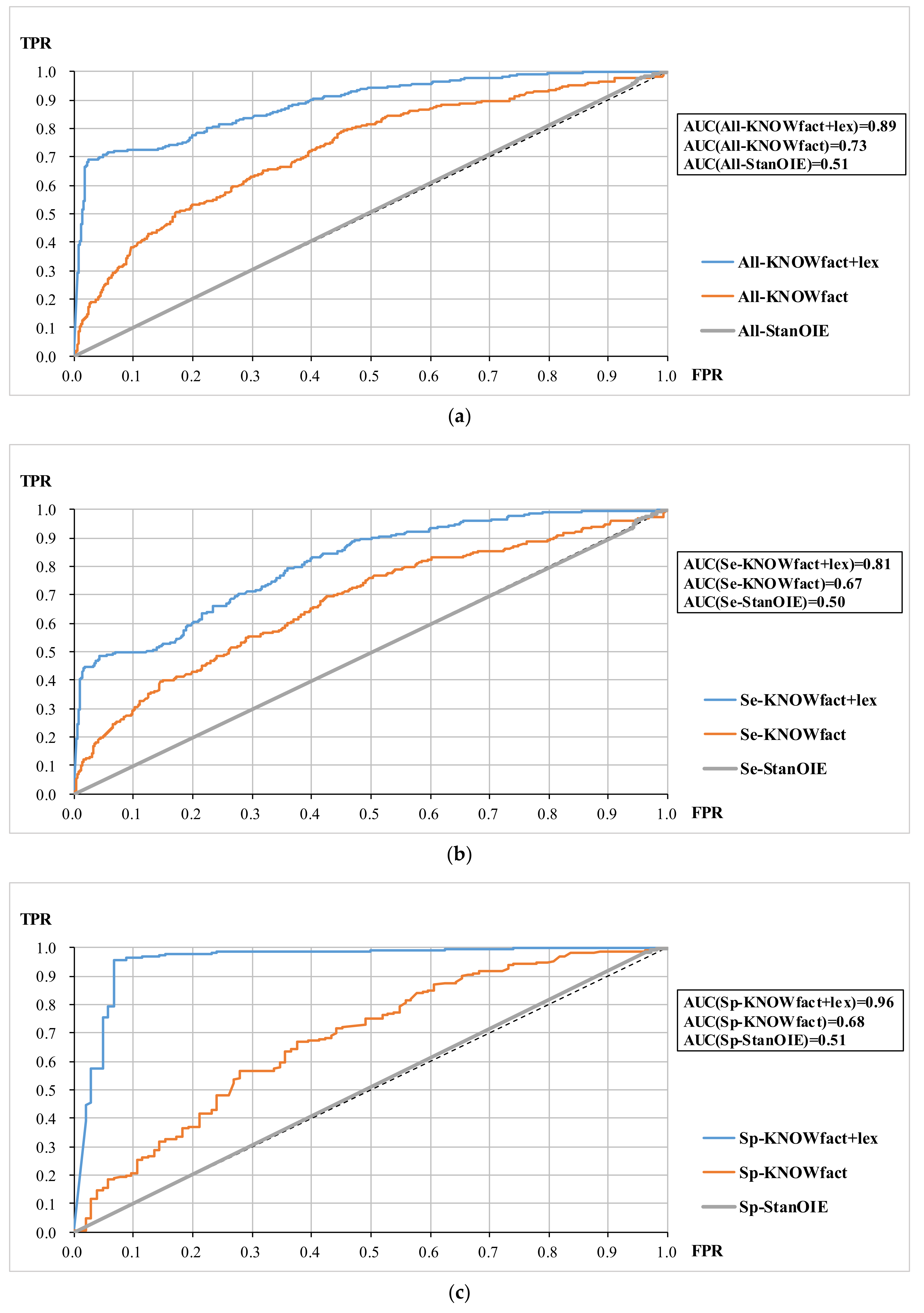
5.2. ROC and AUC
Figure 4a–c shows the ROC curves for all samples, semantic relation samples, and spatial relation samples, respectively. In each group of samples, the ROC curve of KNOWfact+lex completely envelops the ROC curves of KNOWfact and StanOIE. Besides, the AUC value intuitively reflects the superiority of adding the topological words, which reaches a high level (AUC(Sp-KNOWfact+lex) = 0.96) for spatial relation triples. This indicates that synonym knowledge plays a pivotal role in estimating spatial relations.
The ROC curves of StanOIE are close to the 0-1 diagonal, meaning that the confidences predicted by StanOIE are similar to random results. Thus, StanOIE cannot be directly used for extracting geo-entity relation triples.
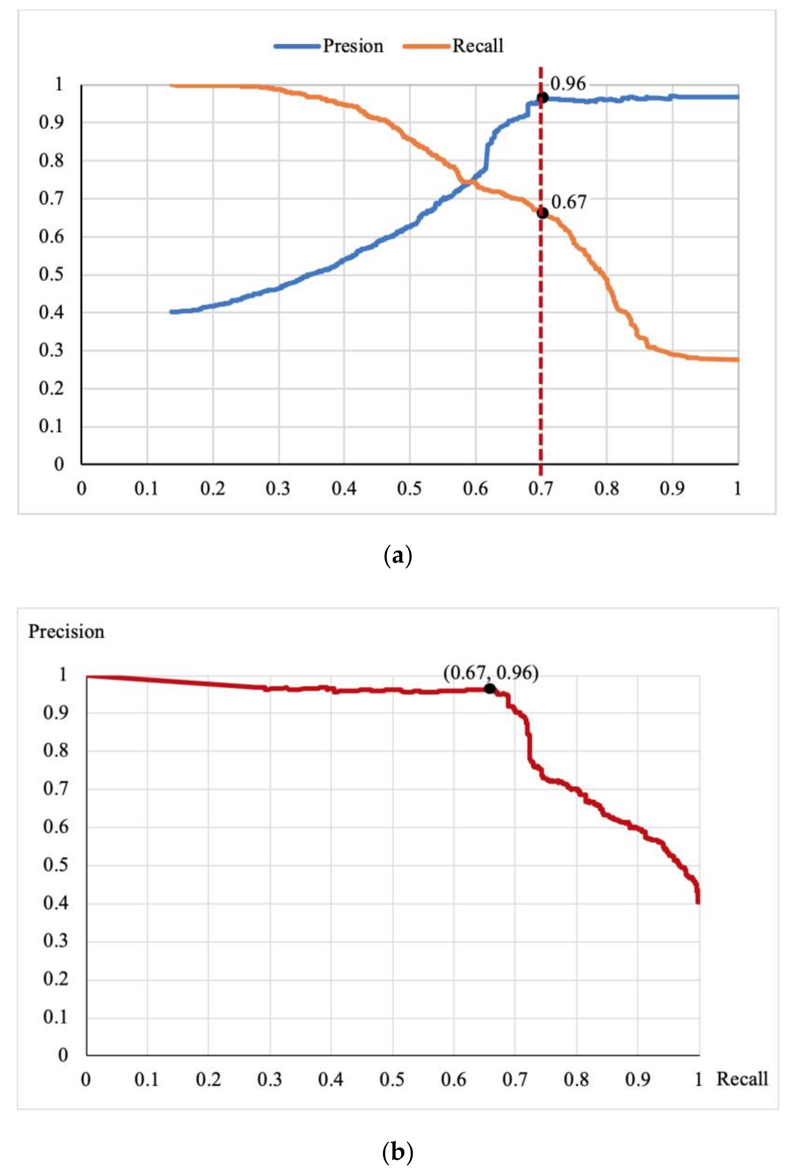
5.3. Determine the Threshold
We analyze the relationship between precision and recall, to determine an appropriate threshold for generating credible triples.
Figure 5a shows the precision curve and the recall curve changing with different thresholds. When the threshold is 0.7, the precision is 0.96 and the recall is 0.67. When the threshold is greater than 0.7, the precision remains steady but the recall drops sharply.
Figure 5b shows a curve in which recall varies with precision. It implies that the precision and recall maintain a good balance when the threshold is less than 0.7. When the recall is greater than 0.7, the precision drops severely, although the recall continues to improve. Therefore, we set 0.7 as the confidence threshold to filter out credible triples of geo-entity relations.
5.4. Effect of Credible Triple Filtering
Ideally, we wish to predict lower confidence for negative samples (manual annotation is 0) and higher confidence for positive samples (manual annotation is 1).
Table 3 shows the percentages of the predictions on negative and positive samples in the range of [0,0.3) and [0.7, 1], respectively, so as to analyze the consistency between the predicted confidence values and the manual annotations.
For the negative samples in three groups, KNOWfact+lex always accounts for the highest percentage below a probability of 0.3 and the lowest percentage above a probability of 0.7. Similarly, for the positive samples in three groups, KNOWfact+lex accounts for a higher percentage above a probability of 0.7 and a lower percentage below a probability of 0.3 than KNOWfact. In particular, for positive samples of spatial relations, none of the KNOWfact+lex output is for the confidence interval [0,0.3), but 95.75% is for the confidence interval [0.7, 1], as shown in
Table 3c. This confirms that the geographical knowledge extended by synonym KBs can effectively distinguish the correct spatial relations.
Although StanOIE filters out almost all positive samples, it judges most of the negative samples to be correct. This indicates that StanOIE always predicts high confidence for its extracted triples irrespective of whether they are correct.
5.5. Discussion
From the experimental results, it can be inferred that the extraction results of Stanford OpenIE should be filtered because it prefers to assign a confidence value of 1.0. The reason for this phenomenon is that current RE tools focus on general relation extraction and mostly use syntactic information to predict confidence. These RE methods are based on dependency parsing, and the improvements are also related to syntax, including natural logic [
7], coordination analyzer [
8], linguistic constraints [
9], and syntax patterns. Consequently, if triples accord with certain syntactic features (whether obtained by manual or machine learning), they will be outputted with high confidence by these tools. Unfortunately, the complexity of natural language causes a large number of extracted triples to be wrong, even if these triples conform to syntactic features. For example,
<Summer Palace, covers expanse by, WanHill> with a confidence value of 1.0 is extracted from the sentence “Dominated by WanHill, Summer Palace covers an expanse of 2.9 square kilometers” by StanOIE, but this triple is obviously not correct. Therefore, information extracted by RE tools cannot directly support domain applications such as geographical KG construction. Our method solves this program by exploring the semantic connection between geo-classes. With this approach, we are able to achieve the desired filtering effect and have confirmed that external knowledge is critical to domain relation extraction.
Although the presented method successfully filters credible geo-entity relations, its effect is still inhibited by a number of factors. Firstly, our method is based on the results of a current RE tool. If the RE tool outputs a triple whose subject and object have no relationship in the textual description, but its class pair simply conforms to our geo-related knowledge, we still identify this triple as correct. Take the sentence “
In the upper area of the Weilburg Lahntal (the Lhnberg Basin) are mineral springs, such as the famous Selters mineral spring in the municipality of Lhnberg” as an illustration. Stanford OpenIE extracts the triple
<Weilburg, of area be, Lhnberg> from this sentence, and our method assigns confidence of 0.73 to this triple, which conforms to the geo-related knowledge
<Settlement, geolocDepartment, PopulatedPlace>. Secondly, the geo-related knowledge acquired in this paper is not enough to cover all relational expressions in natural language. Many extracted triples describe events, such as (
Apple Inc., receive state aid from, Republic of Ireland), which consists of multiple phrases to explain the relation and is not similar to any obtained knowledge. A solution is the integration of multiple similar types of knowledge from collective KBs. At the data level, the triple accuracy can be enhanced by votes of multiple RE tools. Besides, using Semantic Web alignment techniques [
25] to fuse multiple fact KBs (e.g., Freebase, Yago, Wikidata) will increase the coverage of relational knowledge. At the algorithm level, algorithms such as expectation–maximization [
26] can be invoked to further improve our method’s capacity for estimating unknown geo-entity relations.
6. Conclusions
We have proposed a knowledge-based filtering method for automatic identification of credible geo-entity relations extracted from web text. Multiple knowledge sources were utilized to predict the confidence value of geo-entity relations, which consider the semantic restrictions and diverse expressions of geo-entity relations in natural language. The proposed method decreased the MSE from 0.62 to 0.06 in the confidence interval [0.7, 1], and improved the AUC from 0.51 to 0.89, as compared with the Stanford OpenIE method. Analysis and identification of the best confidence threshold aided in establishing a credible geographical KB. This credible KB, which will serve to geographical KG construction, geo-entity relation corpus annotation, and geographical question answering, can be a good dataset for follow-up research. Future studies will aim to fuse the extracted results of multiple RE tools and integrate the geo-related knowledge of multiple KBs, so as to overcome the limitations of a single KB or extractor. Besides, multiple web texts (such as newswire, social media, and domain literature) can become the corpus to obtain more relations in various language scenes. Meanwhile, this corpus can also be used to train a vector model to improve the performance of semantic similarity methods.


