Quantifying Surface Urban Heat Island Formation in the World Heritage Tropical Mountain City of Sri Lanka

 ,
,  ,
,  ,
, 


Abstract
:
1. Introduction
2. Materials and Methods
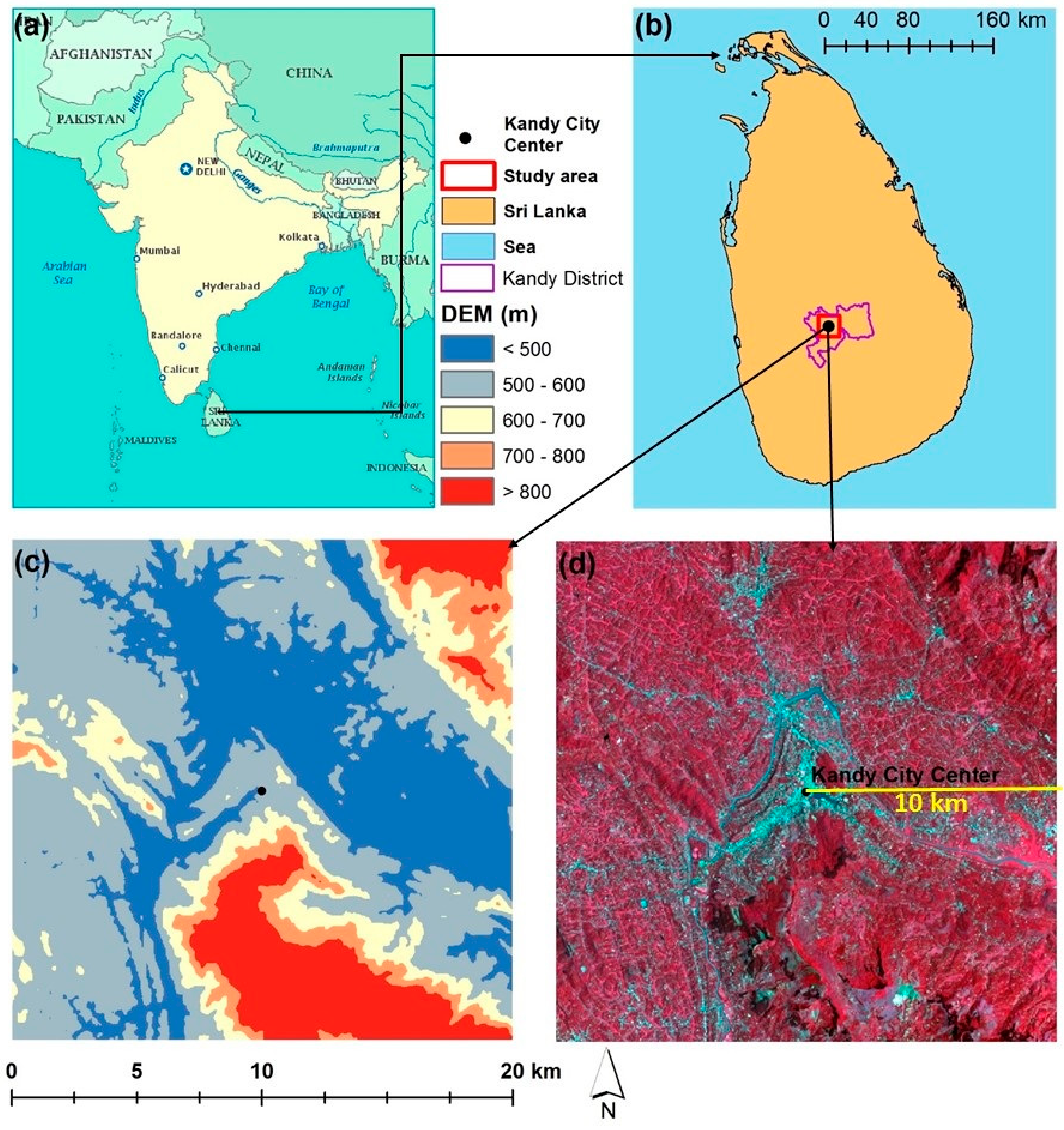
2.1. Study Area: Kandy City, Sri Lanka
2.2. Satellite Data Descriptions and Pre-Processing
2.3. Land Use/Cover Mapping
2.4. LST Retrieval
2.5. SUHI Intensity (SUHII) Measurement
2.6. GS/IS Fraction Ratio along the Urban-Rural Gradient
3. Results
3.1. Land Use/Cover Changes
3.2. LST Distribution in Kandy City
3.3. Magnitude and Trend of SUHII
3.3.1. SUHIIIS-GS Based on the Cross-Cover Comparison
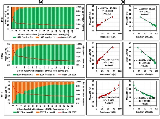
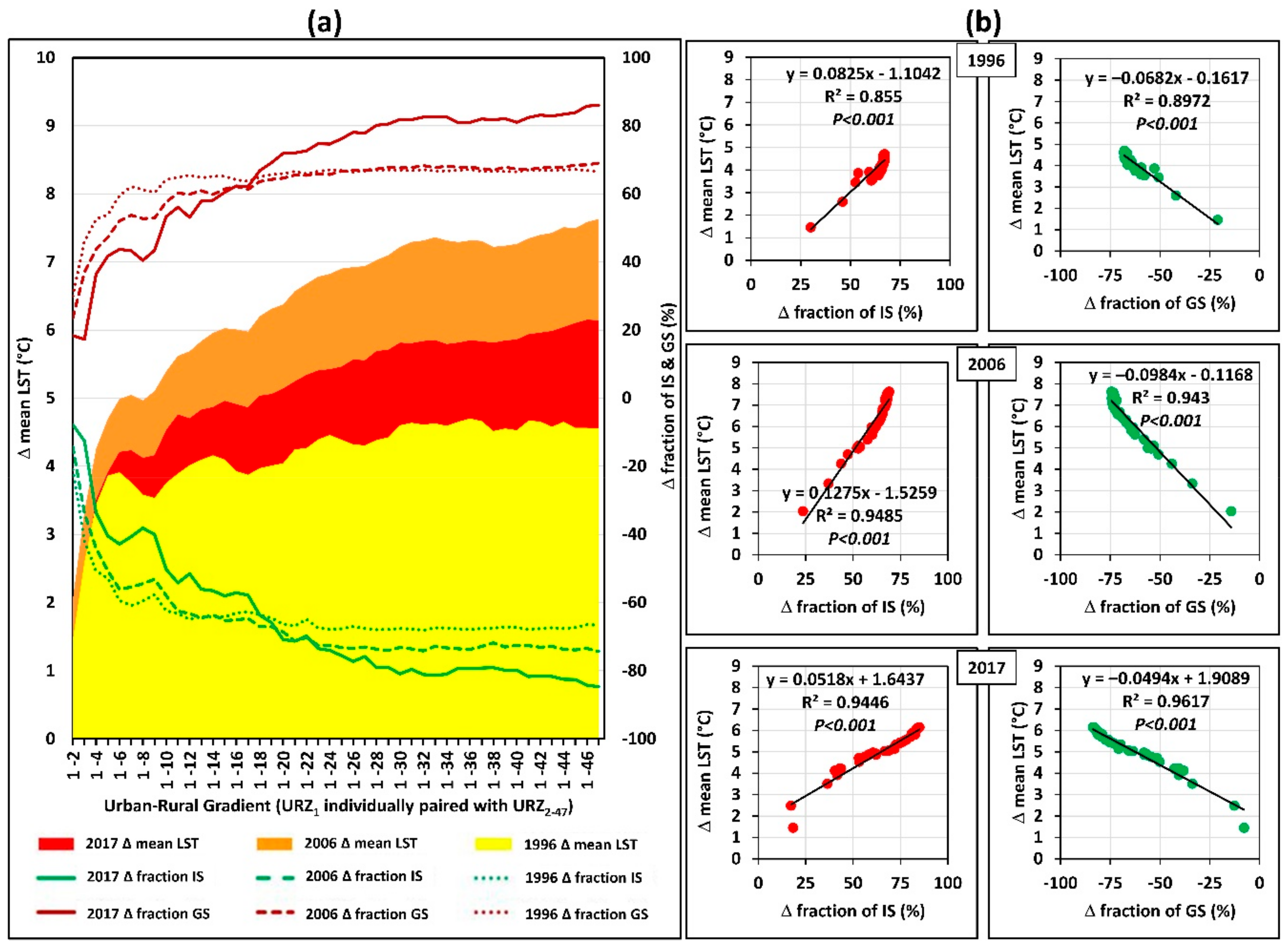
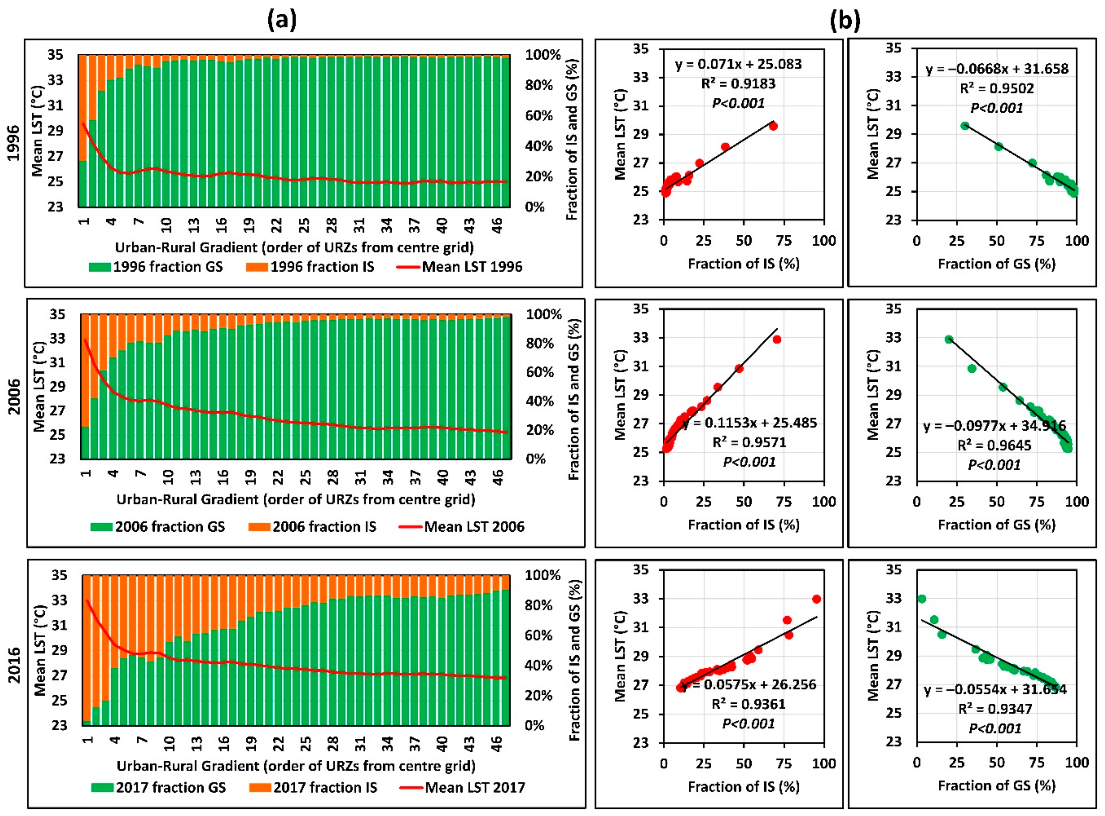
3.3.2. SUHIIU-R along the Urban-Rural Gradient
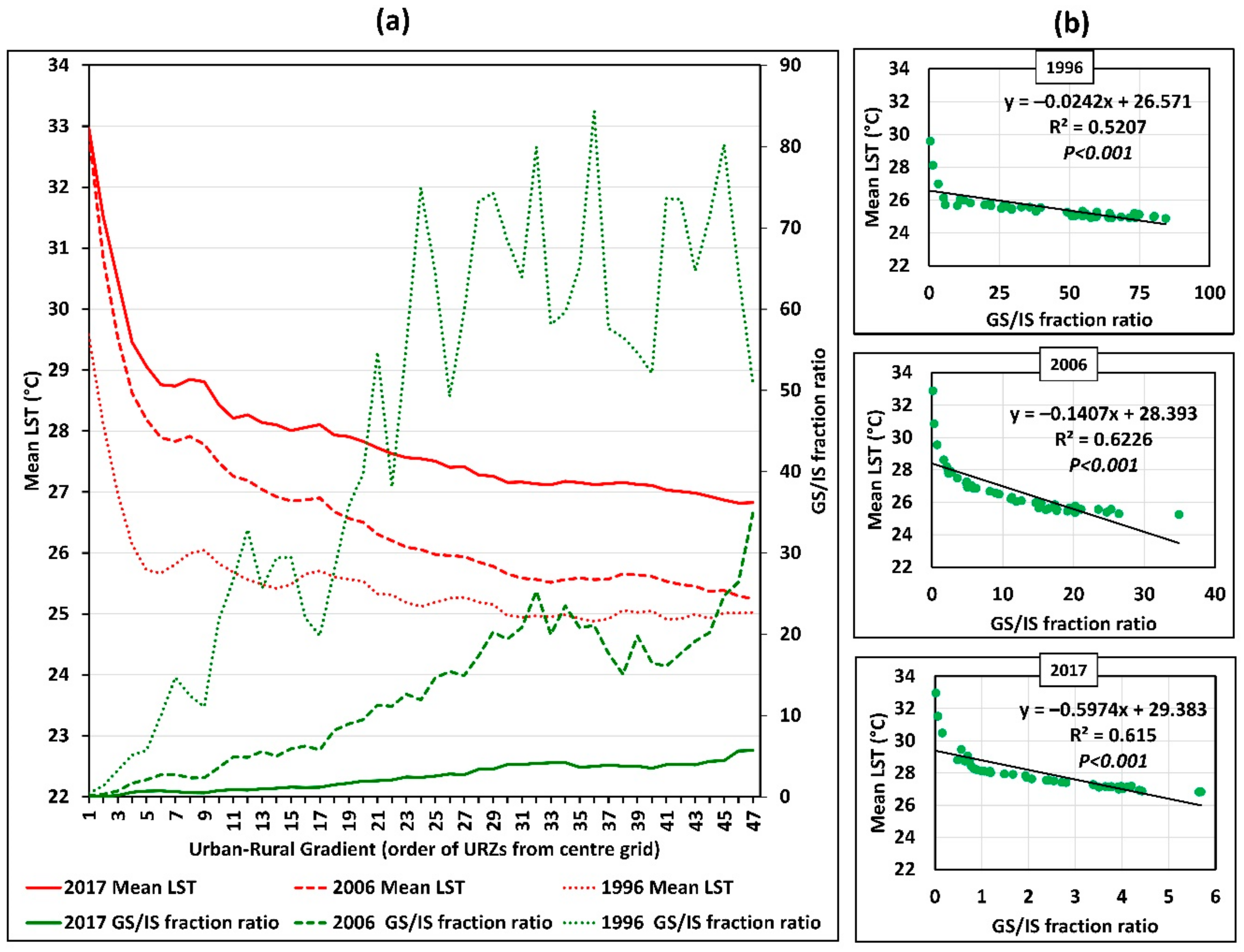
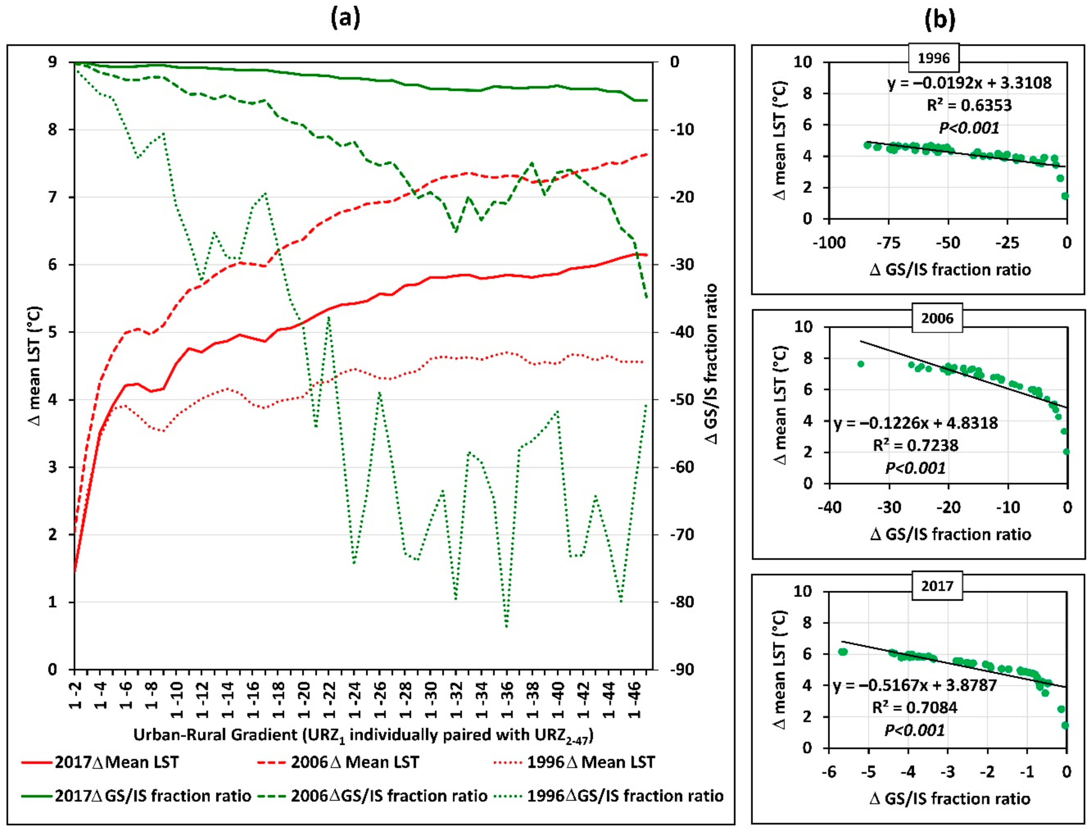
3.4. GS/IS Fraction Ratio along the Urban-Rural Gradient
4. Discussion
4.1. The Urbanization and Its Impact on Kandy City
4.2. SUHI Intensity and Its Effects
4.3. Implications for Urban Sustainability
5. Conclusions
Author Contributions
Funding
Acknowledgments
Conflicts of Interest
References
- Voogt, J.A.; Oke, T.R. Thermal remote sensing of urban climates. Remote Sens. Environ. 2003, 86, 370–384. [Google Scholar] [CrossRef]
- EPA (US Environmental Protection Agency). Reducing Urban Heat Islands: Compendium of Strategies. Available online: https://www.epa.gov/sites/production/files/2014-06/documents/basicscompendium.pdf (accessed on 20 June 2018).
- Kikon, N.; Singh, P.; Singh, S.K.; Vyas, A. Assessment of urban heat islands (UHI) of Noida City, India using multi-temporal satellite data. Sustain. Cities Soc. 2016, 22, 19–28. [Google Scholar] [CrossRef]
- Oke, T.R. City size and the urban heat island. Atmos. Environ. (1967) 1973, 7, 769–779. [Google Scholar] [CrossRef]
- Estoque, R.C.; Murayama, Y. Measuring sustainability based upon various perspectives: A case study of a hill station in Southeast Asia. Ambio 2014, 43, 943–956. [Google Scholar] [CrossRef] [PubMed]
- Estoque, R.C.; Murayama, Y. Quantifying landscape pattern and ecosystem service value changes in four rapidly urbanizing hill stations of Southeast Asia. Landsc. Ecol. 2016, 31, 1481–1507. [Google Scholar] [CrossRef]
- Estoque, R.C.; Murayama, Y. Monitoring surface urban heat island formation in a tropical mountain city using Landsat data (1987–2015). ISPRS J. Photogramm. Remote Sens. 2017, 133, 18–29. [Google Scholar] [CrossRef]
- Ranagalage, M.; Estoque, R.C.; Murayama, Y. An urban heat island study of the Colombo Metropolitan Area, Sri Lanka, based on landsat data (1997–2017). ISPRS Int. J. Geo-Inf. 2017, 6, 189. [Google Scholar] [CrossRef]
- Myint, S.W.; Brazel, A.; Okin, G.; Buyantuyev, A. Combined effects of impervious surface and vegetation cover on air temperature variations in a rapidly expanding desert city. GISci. Remote Sens. 2010, 47, 301–320. [Google Scholar] [CrossRef]
- Xu, H.; Lin, D.; Tang, F. The impact of impervious surface development on land surface temperature in a subtropical city: Xiamen, China. Int. J. Climatol. 2013, 33, 1873–1883. [Google Scholar] [CrossRef]
- Estoque, R.C.; Murayama, Y.; Myint, S.W. Effects of landscape composition and pattern on land surface temperature: An urban heat island study in the megacities of Southeast Asia. Sci. Total. Environ. 2017, 577, 349–359. [Google Scholar] [CrossRef] [PubMed]
- Rizwan, A.M.; Dennis, L.Y.C.; Liu, C. A review on the generation, determination and mitigation of Urban Heat Island. J. Environ. Sci. 2008, 20, 120–128. [Google Scholar] [CrossRef]
- Ranagalage, M.; Estoque, R.C.; Zhang, X.; Murayama, Y. Spatial changes of urban heat island formation in the Colombo District, Sri Lanka: Implications for sustainability planning. Sustainability 2018, 10, 1367. [Google Scholar] [CrossRef]
- Sakakibara, Y.; Owa, K. Urban-rural temperature differences in coastal cities: Influence of rural sites. Int. J. Climatol. 2005, 25, 811–820. [Google Scholar] [CrossRef]
- Bokaie, M.; Zarkesh, M.K.; Arasteh, P.D.; Hosseini, A. Assessment of urban heat island based on the relationship between land surface temperature and land use/land cover in Tehran. Sustain. Cities Soc. 2016, 23, 94–104. [Google Scholar] [CrossRef]
- Estoque, R.C.; Murayama, Y. City Profile: Baguio. Cities 2013, 30, 240–251. [Google Scholar] [CrossRef]
- Chen, X.; Zhang, Y. Impacts of urban surface characteristics on spatiotemporal pattern of land surface temperature in Kunming of China. Sustain. Cities Soc. 2017, 32, 87–99. [Google Scholar] [CrossRef]
- Chen, X.L.; Zhao, H.M.; Li, P.X.; Yin, Z.Y. Remote sensing image-based analysis of the relationship between urban heat island and land use/cover changes. Remote Sens. Environ. 2006, 104, 133–146. [Google Scholar] [CrossRef]
- Oke, T.R. The energetic basis of the urban heat island. Q. J. R. Meteorol. Soc. 1982, 108, 1–24. [Google Scholar] [CrossRef]
- Arnfield, A.J. Two decades of urban climate research: A review of turbulence, exchanges of energy and water, and the urban heat island. Int. J. Climatol. 2003, 23, 1–26. [Google Scholar] [CrossRef]
- Gunaalan, K.; Ranagalage, M.; Gunarathna, M.H.J.P.; Kumari, M.K.N.; Vithanage, M.; Srivaratharasan, T.; Saravanan, S.; Warnasuriya, T.W.S. Application of geospatial techniques for groundwater quality and availability assessment: A case study in Jaffna Peninsula, Sri Lanka. ISPRS Int. J. Geo-Inf. 2018, 7, 20. [Google Scholar] [CrossRef]
- Weng, Q.; Lu, D.; Schubring, J. Estimation of land surface temperature-vegetation abundance relationship for urban heat island studies. Remote Sens. Environ. 2004, 89, 467–483. [Google Scholar] [CrossRef]
- Oke, T.R. Initial Guidance to Obtain Representative Meteorological Observations at Urban Sites. Available online: http://blogs.ubc.ca/toke/files/2015/12/IOM-81-UrbanMetObs.pdf (accessed on 20 June 2018).
- Stewart, I.; Oke, T. Classifying Urban Climate Field Sites by “Local Climate Zones”: The Case of Nagano, Japan. Available online: http://www.ide.titech.ac.jp/~icuc7/extended_abstracts/pdf/385055-1-090515165722-002.pdf (accessed on 20 June 2018).
- Ranagalage, M.; Estoque, R.C.; Handayani, H.H.; Zhang, X.; Morimoto, T.; Tadono, T.; Murayama, Y. Relation between urban volume and land surface temperature: A comparative study of planned and traditional cities in Japan. Sustainability 2018, 10, 2366. [Google Scholar] [CrossRef]
- Xiao, R.; Ouyang, Z.; Zheng, H.; Li, W.; Schienke, E.W.; Wang, X. Spatial pattern of impervious surfaces and their impacts on land surface temperature in Beijing, China. J. Environ. Sci. 2007, 19, 250–256. [Google Scholar] [CrossRef]
- Li, X.; Zhou, W.; Ouyang, Z.; Xu, W.; Zheng, H. Spatial pattern of greenspace affects land surface temperature: Evidence from the heavily urbanized Beijing metropolitan area, China. Landsc. Ecol. 2012, 27, 887–898. [Google Scholar] [CrossRef]
- Senanayake, I.P.; Welivitiya, W.D.D. P.; Nadeeka, P.M. Remote sensing based analysis of urban heat islands with vegetation cover in Colombo city, Sri Lanka using Landsat-7 ETM+ data. Urban Clim. 2013, 5, 19–35. [Google Scholar] [CrossRef]
- Meetiyagoda, L. Pedestrian safety in Kandy Heritage City, Sri Lanka: Lessons from World Heritage Cities. Sustain. Cities Soc. 2018, 38, 301–308. [Google Scholar] [CrossRef]
- UNESCO. Available online: https://whc.unesco.org/en/list/450 (accessed on 15 June 2018).
- Weerasundara, L.; Amarasekara, R.W.K.; Magana-Arachchi, D.N.; Ziyath, A.M.; Karunaratne, D.G.G.P.; Goonetilleke, A.; Vithanage, M. Microorganisms and heavy metals associated with atmospheric deposition in a congested urban environment of a developing country: Sri Lanka. Sci. Total Environ. 2017, 584–585, 803–812. [Google Scholar] [CrossRef] [PubMed]
- Department of Meteorology Sri Lanka. Available online: http://www.meteo.gov.lk/index.php?option=com_content&view=article&id=94:climate-of-sri-lanka&catid=20&lang=en&Itemid=310 (accessed on 16 June 2018).
- Liu, K.; Su, H.; Zhang, L.; Yang, H.; Zhang, R.; Li, X. Analysis of the urban heat Island effect in Shijiazhuang, China using satellite and airborne data. Remote Sens. 2015, 7, 4804–4833. [Google Scholar] [CrossRef]
- Sanchez-Hernandez, C.; Boyd, D.S.; Foody, G.M. Mapping specific habitats from remotely sensed imagery: Support vector machine and support vector data description based classification of coastal saltmarsh habitats. Ecol. Inform. 2007, 2, 83–88. [Google Scholar] [CrossRef]
- Petropoulos, G.P.; Kontoes, C.; Keramitsoglou, I. Burnt area delineation from a uni-temporal perspective based on landsat TM imagery classification using Support Vector Machines. Int. J. Appl. Earth Obs. Geoinf. 2011, 13, 70–80. [Google Scholar] [CrossRef]
- Singh, S.K.; Srivastava, P.K.; Gupta, M.; Thakur, J.K.; Mukherjee, S. Appraisal of land use/land cover of mangrove forest ecosystem using support vector machine. Environ. Earth Sci. 2014, 71, 2245–2255. [Google Scholar] [CrossRef]
- Sobrino, J.A.; Jiménez-Muñoz, J.C.; Paolini, L. Land surface temperature retrieval from landsat TM 5. Remote Sens. Environ. 2004, 90, 434–440. [Google Scholar] [CrossRef]
- Zhang, X.; Estoque, R.C.; Murayama, Y. An urban heat island study in Nanchang City, China based on land surface temperature and social-ecological variables. Sustain. Cities Soc. 2017, 32, 557–568. [Google Scholar] [CrossRef]
- Estoque, R.C.; Murayama, Y.; Akiyama, C.M. Pixel-based and object-based classifications using high- and medium-spatial-resolution imageries in the urban and suburban landscapes. Geocarto Int. 2015, 30, 1113–1129. [Google Scholar] [CrossRef]
- Ye, S.; Pontius, R.G.; Rakshit, R. A review of accuracy assessment for object-based image analysis: From per-pixel to per-polygon approaches. ISPRS J. Photogramm. Remote Sens. 2018, 141, 137–147. [Google Scholar] [CrossRef]
- Trusilova, K.; Jung, M.; Churkina, G. On climate impacts of a potential expansion of urban land in Europe. J. Appl. Meteorol. Climatol. 2009, 48, 1971–1980. [Google Scholar] [CrossRef]
- Department of Census and Statistics. Census of Population and Housing 2012. Available online: http://www.statistics.gov.lk/PopHouSat/CPH2011/Pages/Activities/Reports/CPH_2012_5Per_Rpt.pdf (accessed on 16 June 2018).
- Igun, E. Analysis and sustainable management of urban growth’s impact on land surface temperature in Lagos, Nigeria. J. Remote Sens. GIS 2017, 6, 212. [Google Scholar] [CrossRef]
- Sun, Q.; Wu, Z.; Tan, J. The relationship between land surface temperature and land use/land cover in Guangzhou, China. Environ. Earth Sci. 2012, 65, 1687–1694. [Google Scholar] [CrossRef]
- Min, M.; Zhao, H.; Miao, C. Spatio-temporal evolution analysis of the urban heat island: A case study of Zhengzhou City, China. Sustainability 2018, 10, 1992. [Google Scholar] [CrossRef]
- Galagoda, R.U.; Jayasinghe, G.Y.; Halwatura, R.U.; Rupasinghe, H.T. The impact of urban green infrastructure as a sustainable approach towards tropical micro-climatic changes and human thermal comfort. Urban For. Urban Green. 2018, 34, 1–9. [Google Scholar] [CrossRef]


| (a) Description of Landsat images | ||||
|---|---|---|---|---|
| Sensor | Scene ID | Acquisition Date | Time (GMT) | Season |
| Landsat 5 TM | LT51410551996068BKT00 | 8 March 1996 | 04:00:49 | Dry |
| Landsat 5 TM | LT51410552006095BKT00 | 5 April 2006 | 04:45:26 | Dry |
| Landsat 8 OLI/TIRS | LC81410552017077LGN00 | 18 March 2017 | 04:53:36 | Dry |
| (b) The weather conditions of the study area (Data source: Department of Meteorology, Sri Lanka) | ||||
| Weather parameters | Acquisition Date | 8 March 1996 | 5 April 2006 | 8 March 2017 |
| Air Temperature (°C) | Maximum | 32 | 31.5 | 30.8 |
| Minimum | 19.4 | 20.4 | 16.1 | |
| Mean | 25.7 | 25.95 | 23.45 | |
| Relative Humidity (%) | Maximum | 83 | 96 | 86 |
| Minimum | 52 | 67 | 61 | |
| Mean | 67.5 | 81.5 | 73.5 | |
| Rainfall (mm) | Rainfall | 0 | 3.6 | 0 |
| Land Use/Cover | 1996 | 2006 | 2017 | |||
|---|---|---|---|---|---|---|
| Area (ha) | % | Area (ha) | % | Area (ha) | % | |
| Impervious surface | 911.3 | 2.3 | 1894.1 | 4.7 | 7474.6 | 18.7 |
| Green space 1 (forest) | 25,875.1 | 64.6 | 22,535.0 | 56.3 | 19,563.9 | 48.9 |
| Green space 2 (grassland, cropland) | 12,747.9 | 31.8 | 13,957.8 | 34.9 | 11,707.0 | 29.2 |
| Bare land | 222.3 | 0.6 | 1112.8 | 2.8 | 1035.3 | 2.6 |
| Water | 283.5 | 0.7 | 540.3 | 1.3 | 259.2 | 0.6 |
| Total | 40,040 | 100 | 40,040 | 100 | 40,040 | 100 |
| Land Use/Cover | 1996–2006 | 2006–2017 | 1996–2017 | |||
|---|---|---|---|---|---|---|
| Land Use/Cover Changes (ha) | Annual Growth Rate (ha per Year) | Land Use/Cover Changes | Annual Growth Rate (ha per Year) | Land Use/Cover Changes | Annual Growth Rate (ha per Year) | |
| Impervious Surface | 982.8 | 98.3 | 5580.5 | 507.3 | 6563.3 | 312.5 |
| Green space 1 (forest) | −3340.1 | −334.0 | −2971.1 | −270.1 | −6311.2 | −300.5 |
| Green space 2 (grassland, cropland) | 1209.9 | 121.0 | −2250.8 | −204.6 | −1040.9 | −49.6 |
| Bare land | 890.5 | 89.1 | −77.5 | −7.0 | 813.0 | 38.7 |
| Water | 256.8 | 25.7 | −281.1 | −25.6 | −24.3 | −1.2 |
| (a) Mean LST of IS and GS (°C) | ||||
| Land Use/Cover | 1996 | 2006 | 2017 | Change (2017–1996) |
| IS | 27.7 | 28.4 | 29.0 | 1.3 |
| GS 1 | 24.7 | 25.4 | 26.7 | 2.0 |
| GS 2 | 25.8 | 26.3 | 27.4 | 1.6 |
| GSa | 25.3 | 25.8 | 27.0 | 1.7 |
| (b) Magnitude and trend of SUHII (°C) | ||||
| Land use/cover (cross-cover comparison) | SUHIIIS-GS (∆ mean LST) | Average (2017–1996) | ||
| 1996 | 2006 | 2017 | ||
| IS–GS 1 | 3.0 | 3.0 | 2.3 | 2.8 |
| IS–GS 2 | 1.9 | 2.1 | 1.6 | 1.9 |
| GS 2–GS 1 | 1.1 | 0.9 | 0.7 | 0.9 |
| IS–GSa | 2.4 | 2.6 | 2.0 | 2.3 |
© 2018 by the authors. Licensee MDPI, Basel, Switzerland. This article is an open access article distributed under the terms and conditions of the Creative Commons Attribution (CC BY) license (http://creativecommons.org/licenses/by/4.0/).
Share and Cite
Ranagalage, M.; Dissanayake, D.; Murayama, Y.; Zhang, X.; Estoque, R.C.; Perera, E.; Morimoto, T. Quantifying Surface Urban Heat Island Formation in the World Heritage Tropical Mountain City of Sri Lanka. ISPRS Int. J. Geo-Inf. 2018, 7, 341. https://doi.org/10.3390/ijgi7090341
Ranagalage M, Dissanayake D, Murayama Y, Zhang X, Estoque RC, Perera E, Morimoto T. Quantifying Surface Urban Heat Island Formation in the World Heritage Tropical Mountain City of Sri Lanka. ISPRS International Journal of Geo-Information. 2018; 7(9):341. https://doi.org/10.3390/ijgi7090341
Chicago/Turabian StyleRanagalage, Manjula, DMSLB Dissanayake, Yuji Murayama, Xinmin Zhang, Ronald C. Estoque, ENC Perera, and Takehiro Morimoto. 2018. "Quantifying Surface Urban Heat Island Formation in the World Heritage Tropical Mountain City of Sri Lanka" ISPRS International Journal of Geo-Information 7, no. 9: 341. https://doi.org/10.3390/ijgi7090341
APA StyleRanagalage, M., Dissanayake, D., Murayama, Y., Zhang, X., Estoque, R. C., Perera, E., & Morimoto, T. (2018). Quantifying Surface Urban Heat Island Formation in the World Heritage Tropical Mountain City of Sri Lanka. ISPRS International Journal of Geo-Information, 7(9), 341. https://doi.org/10.3390/ijgi7090341