Assessing the Impacts of Streamside Ordinance Protection on the Spatial and Temporal Variability in Urban Riparian Vegetation


Abstract
:1. Introduction
2. Materials and Methods
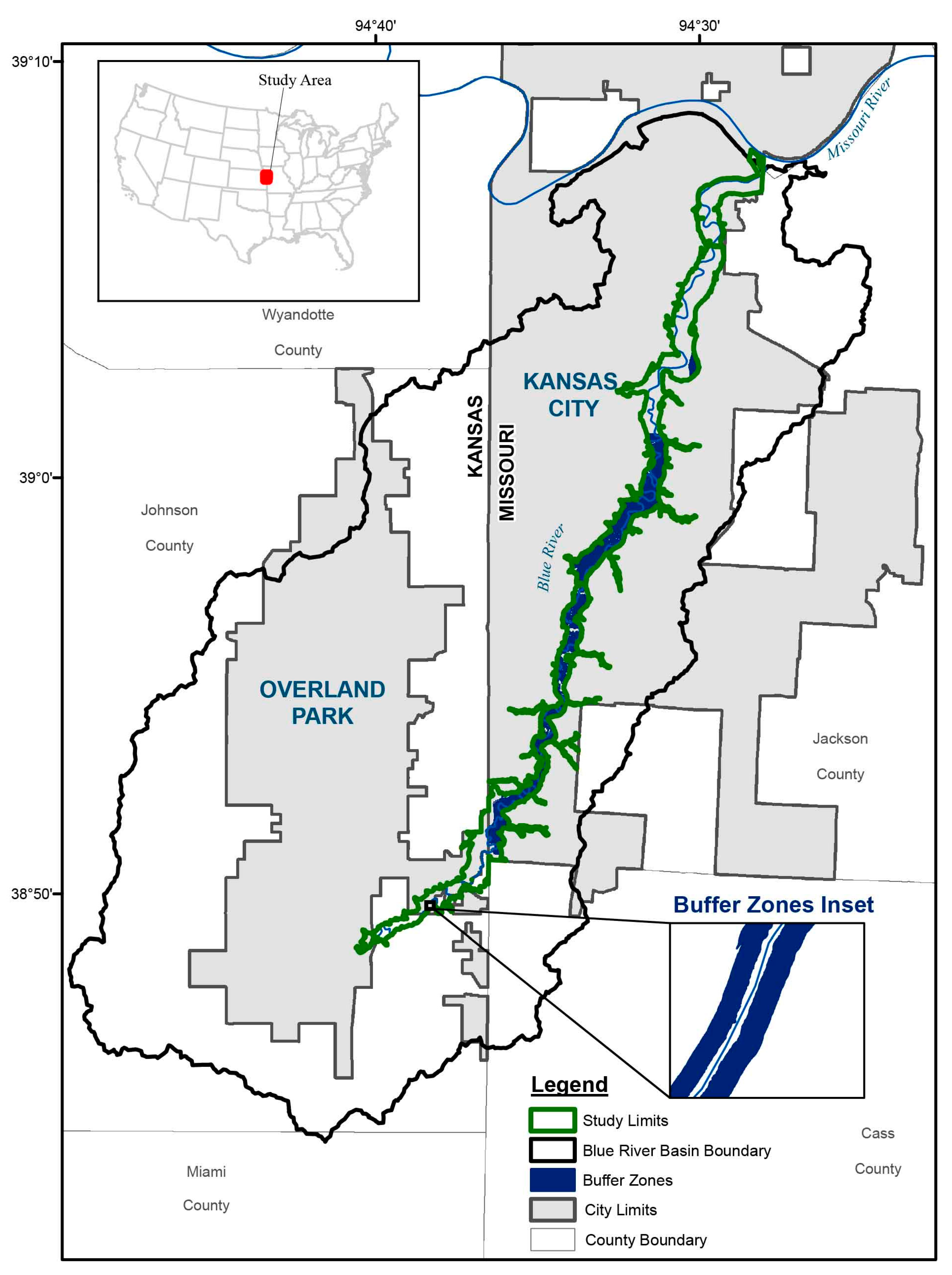
2.1. Defined Riparian Area
2.2. Streamside Ordinances
2.3. Description of Imagery and Processing
2.4. Data Analysis
3. Results
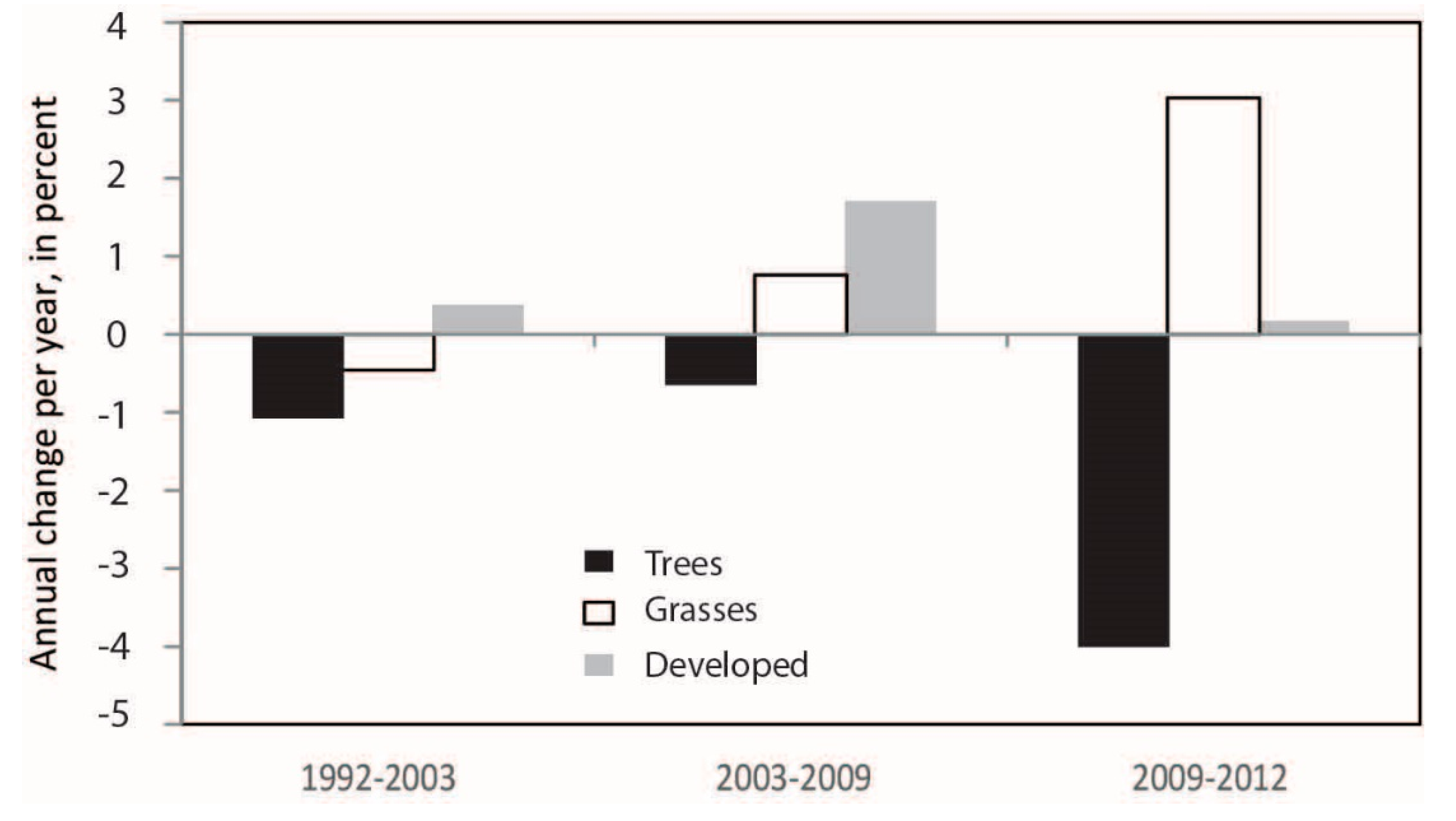
3.1. Total Riparian Vegetation Change within the Study Area
3.2. Riparian Vegetation Change by Municipality and Ordinance Protection
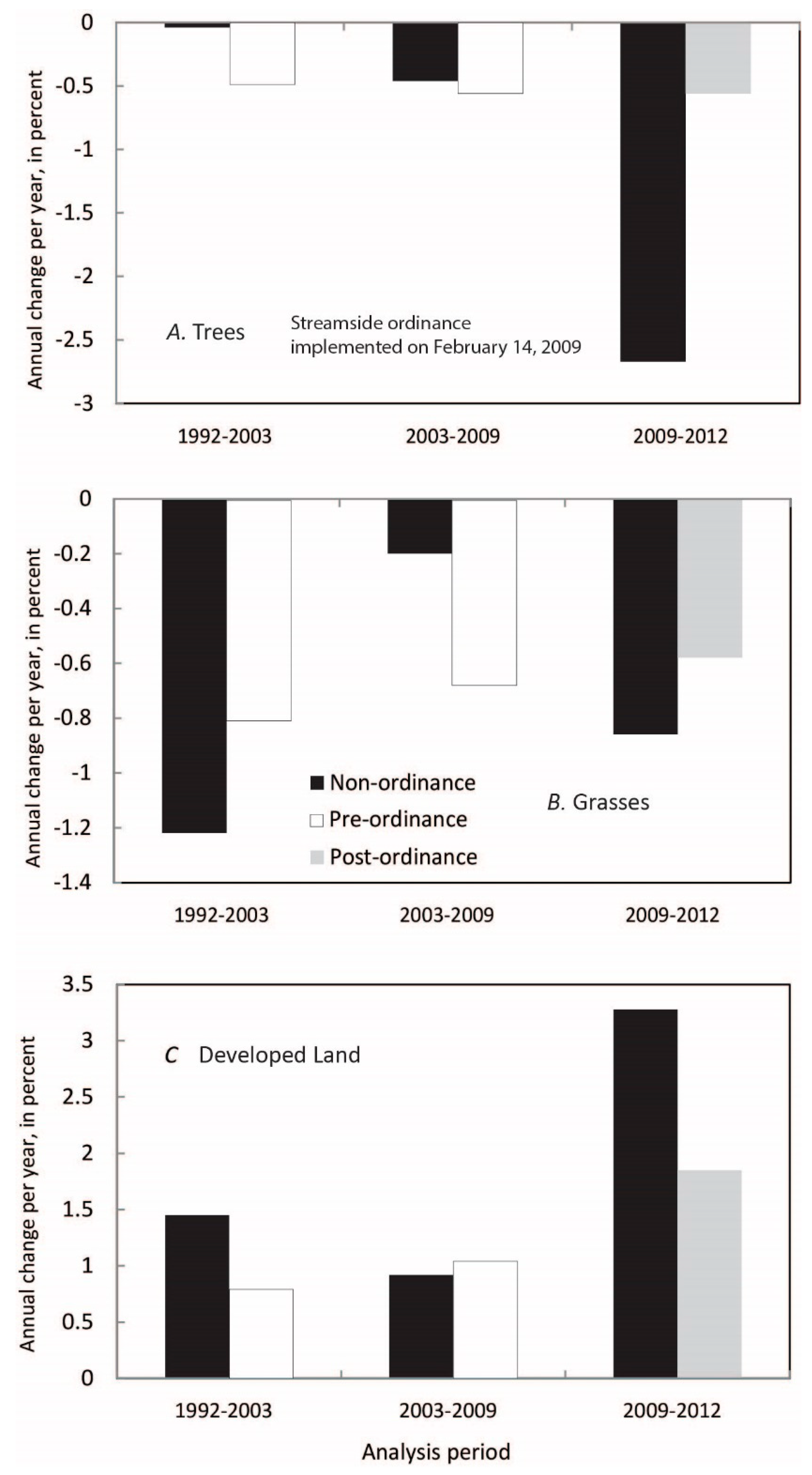
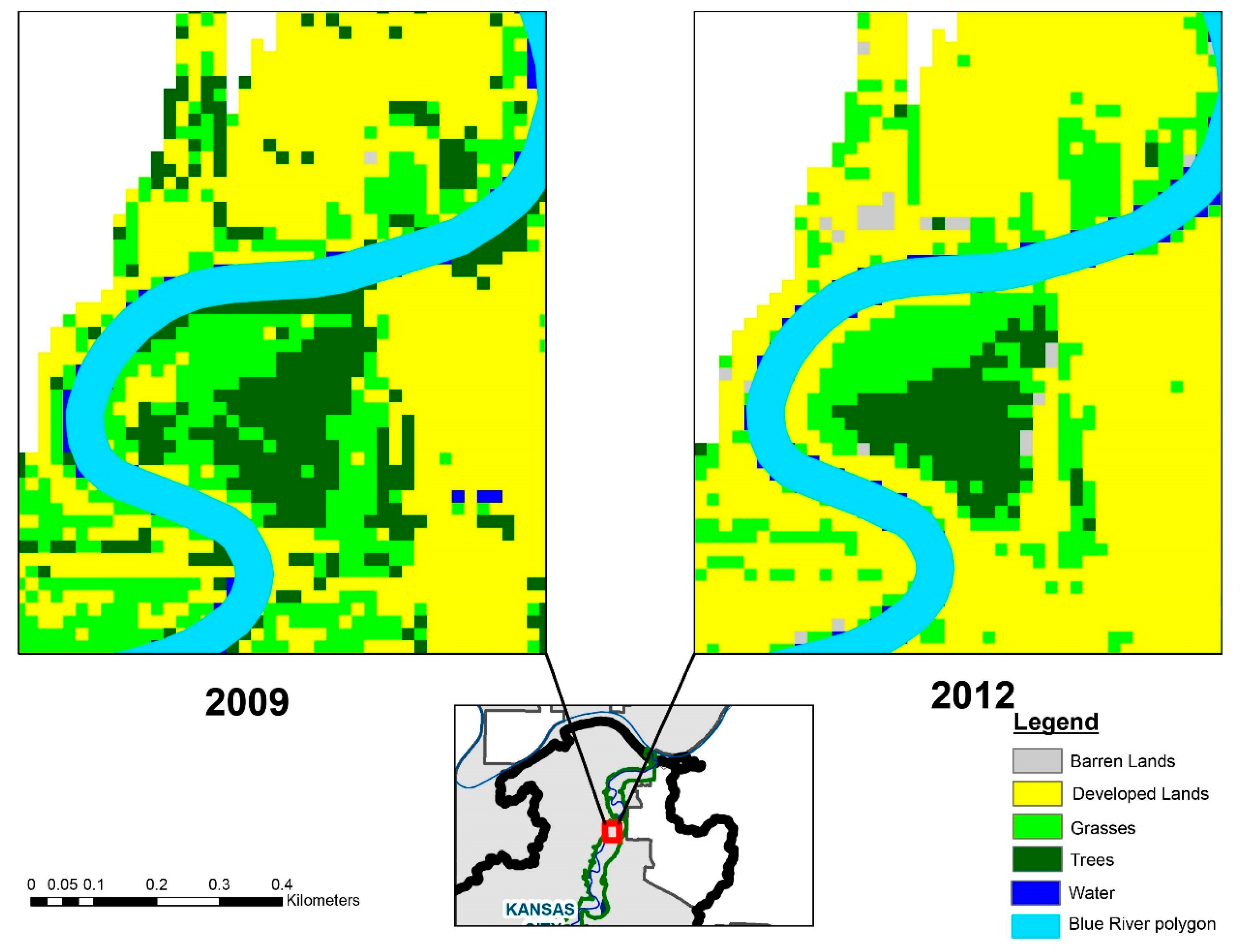
3.2.1. City of Kansas City
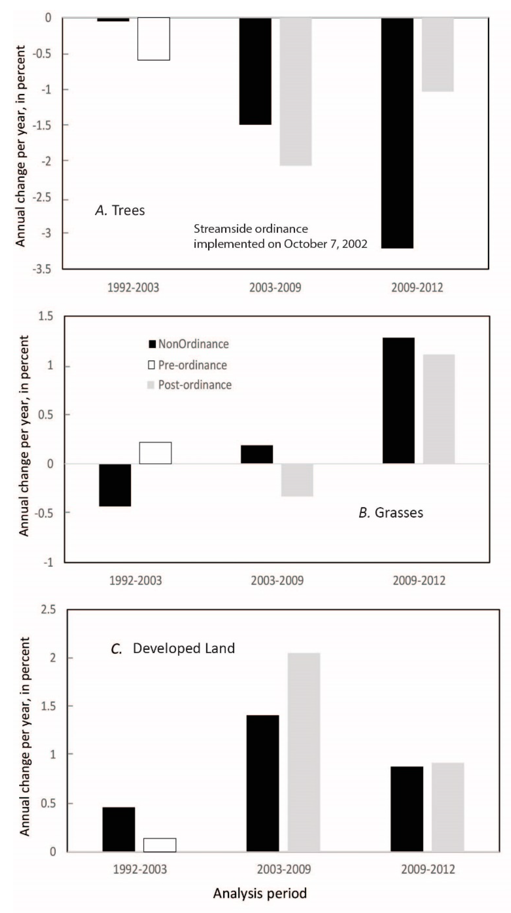
3.2.2. City of Overland Park
3.2.3. Unincorporated Johnson County, KS, USA
4. Discussion
4.1. Total Riparian Vegetation Change within the Study Area
4.2. Riparian Vegetation Change by Municipality and Ordinance Protection
5. Conclusions
Author Contributions
Acknowledgments
Conflicts of Interest
References
- Gregory, S.; Swanson, F.; McKee, W.; Cummins, K. An Ecosystem Perspective of Riparian Zones. Bioscience 1991, 41, 540–551. [Google Scholar] [CrossRef]
- National Research Council. Wetlands: Characteristics and Boundaries; National Academy Press: Washington, DC, USA, 1995; ISBN 0-309-05134-7. [Google Scholar]
- Naiman, R.; Décamps, H. The Ecology of Interfaces: Riparian Zones. Annu. Rev. Ecol. Syst. 1997, 28, 621–658. [Google Scholar] [CrossRef]
- Groffman, P.; Bain, D.; Bond, L.; Belt, K.; Brush, G.; Grove, M.; Pouyat, R.; Yesilonis, I.; Zipperer, W. Down by the riverside: Urban Riparian Ecology. Front. Ecol. Environ. 2003, 1, 315–321. [Google Scholar] [CrossRef]
- Johnston, C.; Naiman, R. Browse selection by beaver: Effects on riparian forest composition. Can. J. For. Res. 1990, 20, 1036–1043. [Google Scholar] [CrossRef]
- Holman-Dodds, J.; Bradley, A.; Potter, K. Evaluation of hydrologic benefits of infiltration based urban storm water management. J. Am. Water Resour. Assoc. 2003, 39, 205–215. [Google Scholar] [CrossRef]
- Sweeney, W. Streamside forests and the physical, chemical, and trophic characteristics of Piedmont streams in eastern North America. Water Sci. Technol. 1992, 26, 2653–2673. [Google Scholar] [CrossRef]
- Lowrance, R.; Leonard, R.; Sheridan, J. Managing riparian ecosystems to control nonpoint pollution. J. Soil Water Conserv. 1985, 40, 87–91. [Google Scholar]
- U.S. Environmental Protection Agency. Clean Water Act Section 303(d): Impaired Waters and Total Maximum Daily Loads (TMDLs). Available online: http://water.epa.gov/polwaste/npdes/swbmp/Riparian-Forested-Buffer.cfm (accessed on 7 July 2017).
- Burton, M.; Samuelson, L. Influence of urbanization on riparian forest diversity and structure in the Georgia Piedmont, U.S. Plant Ecol. 2007, 195, 99–115. [Google Scholar] [CrossRef]
- Atkinson, S.; Hunter, B.; English, A. Prioritizing riparian corridors for water quality protection in urbanizing watersheds. J. Water Resour. Prot. 2010, 2, 675–682. [Google Scholar] [CrossRef]
- Bettez, N.; Groffman, P. Denitrification potential in stormwater control structures and natural riparian zones in an urban landscape. Environ. Sci. Technol. 2012, 46, 10909–10917. [Google Scholar] [CrossRef] [PubMed]
- Hatt, B.; Fletcher, T.; Walsh, C.; Taylor, S. The influence of urban density and drainage infrastructure on the concentrations and loads of pollutants in small streams. Environ. Manag. 2004, 34, 112–124. [Google Scholar] [CrossRef] [PubMed]
- Pickett, S.; Cadenasso, M.; Grove, J.; Groffman, P.; Band, L.; Boone, C. Beyond urban legends: An emerging framework of urban ecology, as illustrated by the Baltimore ecosystem study. Bioscience 2008, 58, 139–150. [Google Scholar] [CrossRef]
- Luck, G.; Smallbone, L.; O’Brien, R. Socio-economics and vegetation change in urban ecosystems: Patterns in space and time. Ecosystems 2009, 12, 604–620. [Google Scholar] [CrossRef]
- Sohl, T.; Sleeter, B. Role of remote sensing for land-use and land-cover change modeling. In Remote Sensing of Land Use and Land Cover, Principals and Applications; Giri, C., Ed.; CRC Press: Boca Raton, FL, USA, 2012; pp. 225–240. ISBN 9781420070743. [Google Scholar]
- U.S. Environmental Protection Agency. Aquatic Buffer Model Ordinance. Available online: https://www.epa.gov/sites/production/files/2015-12/documents/2002_09_19_nps_ordinanceuments_buffer_model_ordinance1.pdf (accessed on 11 November 2016).
- Lazdinis, M.; Angelstam, P. Functionality of riparian forest ecotones in the context of former Soviet Union and Swedish forest management histories. For. Policy Econ. 2005, 7, 321–332. [Google Scholar] [CrossRef]
- Ferreira, T.; Aguiar, F.; Nogueira, C. Changes in riparian woods over space and time; Influence of environment and land use. For. Ecol. Manag. 2005, 212, 145–159. [Google Scholar] [CrossRef]
- Hatfield, J.; Mickelson, S.; Baker, J.; Arora, K.; Tierney, D.; Peter, C. Buffer strips: Landscape modification to reduce off-site herbicide movement. In Clean Water, Clean Environment, 21st Century: Team Agriculture, Working to Protect Water Resources, Proceedings of a Conference, Kansas City, MO, USA, 5–8 March 1995; American Society of Agricultural Engineers: St. Joseph, MI, USA, 1995; Volume 1, pp. 85–88. [Google Scholar]
- Burke, V.; Gibbons, J. Terrestrial buffer zones and wetland conservation: A case study of freshwater turtles in a Carolina Bay. Conserv. Biol. 1995, 9, 1365–1369. [Google Scholar] [CrossRef]
- Naiman, R.; Decamps, H.; Pollock, M. The Role of riparian corridors in maintaining regional biodiversity. Ecol. Appl. 1993, 3, 209–212. [Google Scholar] [CrossRef] [PubMed]
- Ozawa, C.; Yeakley, J. Performance of management strategies in the protection of riparian vegetation in three Oregon cities. J. Environ. Plan. Manag. 2007, 50, 803–822. [Google Scholar] [CrossRef]
- Yeakley, J.; Ozawa, C.; Hook, A. Changes in vegetated riparian buffers in response to development in three Oregon cities. In Monitoring Science and Technology Symposium: Unifying Knowledge for Sustainability in the Western Hemisphere, Proceedings of RMRS-P-42CD, Denver, CO, USA, 20–24 September 2004; Aguirre-Bravo, C., Pellicane, P., Burns, D., Draggan, S., Eds.; US Department of Agriculture, Forest Service, Rocky Mountain Research Station: Fort Collins, CO, USA, 2006. [Google Scholar]
- U.S. Environmental Protection Agency. Ecoregions. Available online: https://www.epa.gov/eco-research/level-iii-and-iv-ecoregions-state (accessed on 4 April 2017).
- Heimann, D.; Weilert, T.; Kelly, B.; Studley, S. Flood-Inundation Maps and Wetland Restoration Suitability Index for the Blue River and Selected Tributaries, Kansas City, Missouri, and Vicinity, 2012; Scientific Investigations Report 2014-5180; U.S. Geological Survey: Reston, VA, USA, 2015. [Google Scholar]
- U.S. Department of Agriculture, Natural Resources Conservation Service. National List of Hydric Soils. Available online: https://www.nrcs.usda.gov/wps/portal/nrcs/main/soils/use/hydric/ (accessed on 9 September 2016).
- U.S. Fish and Wildlife Service. National Wetlands Inventory. Available online: https://www.fws.gov/wetlands/index.html (accessed on 9 September 2016).
- Walton, J.; Water Services Department, City of Kansas City, MO, USA. Final Version of Stream Buffer Zones Layer. Personal Communication, 2016. [Google Scholar]
- City of Kansas City, Missouri. Stream Buffers. Ordinance §§ 88–415. Available online: https://www.municode.com/library/mo/kansas_city/codes/code_of_ordinances?nodeId=ZODECOKAMI_400_SERIESDEST_88-415STBU_88-415-04FL (accessed on 21 June 2016).
- City of Overland Park. Stream Corridor Requirements. Available online: http://www.opkansas.org/wp-content/uploads/downloads/18365-stream-corridor-requirements.pdf (accessed on 15 November 2015).
- The Centre National D’études Spatiales. SPOT Imagery. Available online: https://cnes.fr/en (accessed on 5 May 2016).
- Tso, B.; Mather, P. Classification Methods for Remote Sensing Data; Taylor & Francis: London, UK, 2001; ISBN 9780415259088. [Google Scholar]
- Jensen, J. Introductory Digital Image Processing, 3rd ed; Prentice Hall: Upper Saddle River, NJ, USA, 2005. [Google Scholar]
- Anderson, J.; Hardy, E.; Roach, J.; Witmer, R. A Land Use and Land Cover Classification System for Use with Remote Sensor Data; 1976 Professional Paper #964; US Geological Survey: Reston, VA, USA, 1976; 28p. [Google Scholar]
- U.S. Department of Agriculture, Farm Service Agency. National Agricultural Imagery Program. Available online: https://gdg.sc.egov.usda.gov (accessed on 20 March 2017).
- Campbell, J.; Wynne, R. Introduction to Remote Sensing, 5th ed.; Guilford Press: New York, NY, USA, 2011; ISBN 978-1609181756. [Google Scholar]
- Mid-America Regional Council. Streams. Available online: http://marc.org/Data-Economy/Maps-and-GIS/GIS-Data/GIS-Datasets/Streams-Metadata (accessed on 22 June 2017).
- Jones, K.B.; Slonecker, E.T.; Nash, M.S.; Neale, A.C.; Wade, T.G.; Hamann, S. Riparian habitat changes across the continental United States (1972–2003) and potential implications for sustaining ecosystem services. Landsc. Ecol. 2010, 25, 1261–1275. [Google Scholar] [CrossRef]
- Leopold, L. Hydrology for Urban Land Planning—A Guidebook of the Hydrologic Effects of Urban Land Use; U.S. Geological Survey Circular 554; U.S. Geological Survey: Reston, VA, USA, 1968. [Google Scholar]
- Wibben, H. Effects of Urbanization on Flood Characteristics in Nashville—Davidson County, Tennessee; Water-Resources Investigations 76-121; U.S. Geological Survey: Reston, VA, USA, 1976. [Google Scholar]
- Shuster, W.; Bonta, J.; Wamemuende, E.; Smith, D. Impacts of impervious surface on watershed hydrology: A review. Urban Water J. 2005, 2, 263–275. [Google Scholar] [CrossRef]
- Jacobson, C. Identification and quantification of the hydrological impacts of imperviousness in urban catchments: A review. Environ. Manag. 2011, 92, 1438–1448. [Google Scholar] [CrossRef] [PubMed]
- U.S. Geological Survey. National Water Information System. Available online: https://nwis.waterdata.usgs.gov/ks/nwis/peak/?site_no=06893080&agency_cd=USGS& (accessed on 23 April 2017).
- National Weather Service. Advanced Hydrologic Prediction Service. Available online: https://water.weather.gov/ahps/rss/ (accessed on 10 July 2017).
- U.S. Army Corps of Engineers. Blue River Channel Modification. Available online: http://www.nwk.usace.army.mil/Missions/Civil-Works/Civil-Works-Programs-And-Projects/Blue-River-Channel-Modification/ (accessed on 3 April 2017).
- U.S. Census Bureau. Census Summary File 1. Available online: www.census.gov/prod/cen2010/doc/sf1.pdf (accessed on 11 May 2017).
- Deksissa, T.; Ashton, P.; Vanrolleghem, P. Control options for river water quality improvement: A case study of TDS and inorganic nitrogen in the Crocodile River (South Africa). Water SA 2003, 29, 209–217. [Google Scholar] [CrossRef]
- Wilkison, D.; Armstrong, D.; Hampton, S. Character and Trends of Water. Quality in the Blue River Basin, Kansas City Metropolitan Area, Missouri and Kansas, 1998 through 2007; Scientific Investigations Report 2009-169; U.S. Geological Survey: Reston, VA, USA, 2009. [Google Scholar]
- McGee, A.; Day, S.; Wynne, R.; White, M. Using Geospatial Tools to Assess the Urban Tree Canopy: Decision Support for Local Governments. J. For. 2012, 110, 275–286. [Google Scholar] [CrossRef]
- Zhang, Q.; Pandey, B. Monitoring annual vegetated land loss to urbanization with Landsat Archive: A case study in Shanghai, China. In Remote Sensing Time Series Image Processing; Weng, Q., Ed.; CRC Press: Boca Raton, FL, USA, 2018; pp. 204–220. ISBN 978-1-13-805459-2. [Google Scholar]


| State | Administrative Area | Area (km2) | Ordinance | Date Enacted |
|---|---|---|---|---|
| Kansas | Overland Park | 0.52 | YES | 7 October 2002 |
| Kansas | Overland Park (Outside ordinance zone) | 3.24 | NO | |
| Kansas | Unincorporated Johnson County | 2.07 | NO | |
| Missouri | Kansas City | 13.73 | YES | 14 February 2009 |
| Missouri | Kansas City (Outside ordinance zone) | 13.58 | NO | |
| Total Area (Area within ordinance zone/Area outside ordinance zone) | 33.14 (14.25/18.89) | |||
| 1992 Accuracy Assessment | 2009 Accuracy Assessment | ||||
| Class Name | Producer’s Accuracy | User’s Accuracy | Class Name | Producer’s Accuracy | User’s Accuracy |
| Barren Land | 71.40% | 83.33% | Barren Land | 87.50% | 82.35% |
| Grasses | 90.91% | 87.91% | Grasses | 92.16% | 92.16% |
| Trees | 89.19% | 88.39% | Trees | 96.15% | 93.46% |
| Urban Land | 84.62% | 86.84% | Urban Land | 92.00% | 94.52% |
| Water | 72.73% | 88.89% | Water | 70.00% | 87.50% |
| Overall Classification Accuracy | 87.89% | Overall Classification Accuracy | 92.58% | ||
| 2003 Accuracy Assessment | 2012 Accuracy Assessment | ||||
| Class Name | Producer’s Accuracy | User’s Accuracy | Class Name | Producer’s Accuracy | User’s Accuracy |
| Barren Land | 72.73% | 88.89% | Barren Land | 80.00% | 88.89% |
| Grasses | 85.07% | 90.48% | Grasses | 88.00% | 93.62% |
| Trees | 93.00% | 90.29% | Trees | 94.68% | 93.69% |
| Urban Land | 92.19% | 93.65% | Urban Land | 94.19% | 91.11% |
| Water | 100.00% | 77.78% | Water | 81.25% | 86.66% |
| Overall Classification Accuracy | 90.23% | Overall Classification Accuracy | 91.80% | ||
| Generalized Land-Cover Class 1 | 1992 (0% of Area within Streamside Ordinance Protection) | 2003 (1.64% of Area within Streamside Ordinance Protection) | 2009 (43% of Area within Streamside Ordinance Protection) | 2012 (43% of Area within Streamside Ordinance Protection) | ||||
|---|---|---|---|---|---|---|---|---|
| Area (km2) | Percent Cover | Area (km2) | Percent Cover | Area (km2) | Percent Cover | Area (km2) | Percent Cover | |
| Barren Land | 0.90 | 2.72% | 0.72 | 2.18% | 0.05 | 0.16% | 0.53 | 1.59% |
| Developed Land | 5.71 | 17.22% | 8.83 | 26.65% | 11.11 | 33.52% | 13.28 | 40.08% |
| Grasses | 12.42 | 37.48% | 9.94 | 30.00% | 9.47 | 28.58% | 9.22 | 27.82% |
| Trees | 12.81 | 38.65% | 12.01 | 36.23% | 10.64 | 32.10% | 8.66 | 26.14% |
| Water | 1.30 | 3.94% | 1.64 | 4.94% | 1.87 | 5.64% | 1.45 | 4.38% |
| Total | 33.14 | 100.00% | 33.14 | 100.00% | 33.14 | 100.00% | 33.14 | 100.00% |
© 2018 by the authors. Licensee MDPI, Basel, Switzerland. This article is an open access article distributed under the terms and conditions of the Creative Commons Attribution (CC BY) license (http://creativecommons.org/licenses/by/4.0/).
Share and Cite
Weilert, T.E.; Ji, W.; Zubair, O.A. Assessing the Impacts of Streamside Ordinance Protection on the Spatial and Temporal Variability in Urban Riparian Vegetation. ISPRS Int. J. Geo-Inf. 2018, 7, 282. https://doi.org/10.3390/ijgi7070282
Weilert TE, Ji W, Zubair OA. Assessing the Impacts of Streamside Ordinance Protection on the Spatial and Temporal Variability in Urban Riparian Vegetation. ISPRS International Journal of Geo-Information. 2018; 7(7):282. https://doi.org/10.3390/ijgi7070282
Chicago/Turabian StyleWeilert, Trina E., Wei Ji, and Opeyemi A. Zubair. 2018. "Assessing the Impacts of Streamside Ordinance Protection on the Spatial and Temporal Variability in Urban Riparian Vegetation" ISPRS International Journal of Geo-Information 7, no. 7: 282. https://doi.org/10.3390/ijgi7070282