GIS Application to Regional Geological Structure Relationship Modelling Considering Semantics
Abstract
:1. Introduction
2. Geological Definitions and the Classification of Geological Relationships
- GB/T9649 The terminology classification codes of geology and mineral resources (containing GB/T 9649.1-35),
- GB958-99 Geological legends used for regional geological maps,
- DZ/T0001-91 Principles for regional geological surveys (1:50,000),
- The Spatial Database of the Digital Geological Map by the China Geological Survey.
3. Modelling Methods for Geological Relationships
3.1. Modelling Approaches
- Based on the geological meaning, design the geometric types, feature class names, and subtypes for a geological object.
- If there exists a topological relationship between geological objects (geological object subtypes), confirm the topological name and the rules of the topological relationship. Then, store the feature classes related to the topological relationship and set the parameters in Geodatabase.
- If an association exists between geological objects, confirm the relation name and rule, and store the origin class and destination class in Geodatabase.
3.2. Modelling for Composition Relationships of Geological Phenomena
3.3. Modelling of Association Relationships of Geological Phenomena
4. Study and Discussion
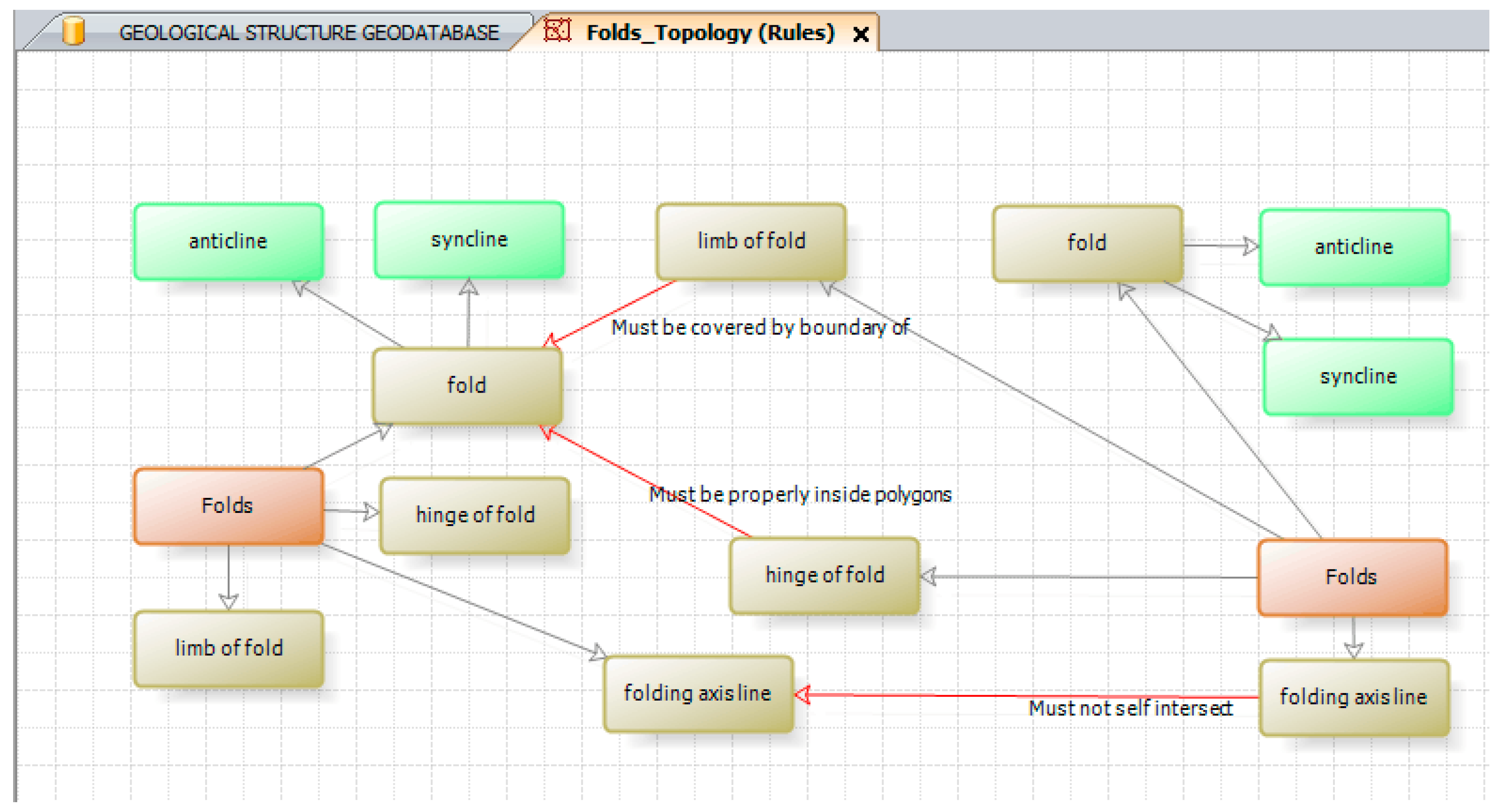
- Three types of topological rules are established in the fold dataset: hinge of fold and fold, limb of fold and fold, and folding axis;
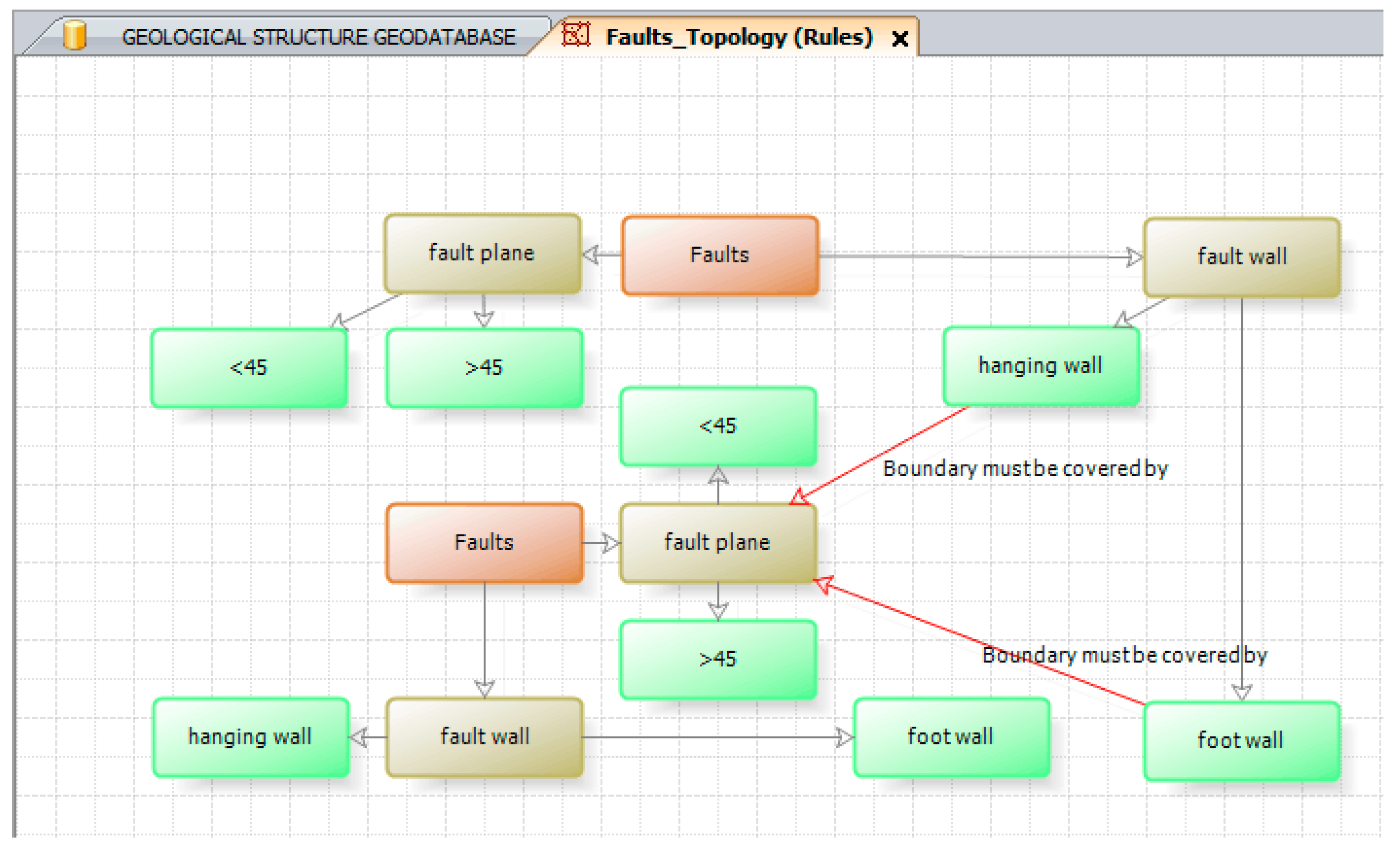
- Two types of topological rules are established in the fault dataset: fault wall (hanging wall) and fault plane and fault wall (foot wall) and fault plane;
- Five types of topological rules are established in the stratum dataset: conformable contact, unconformable contact, intrusive contact, sedimentary contact and faulted contact.
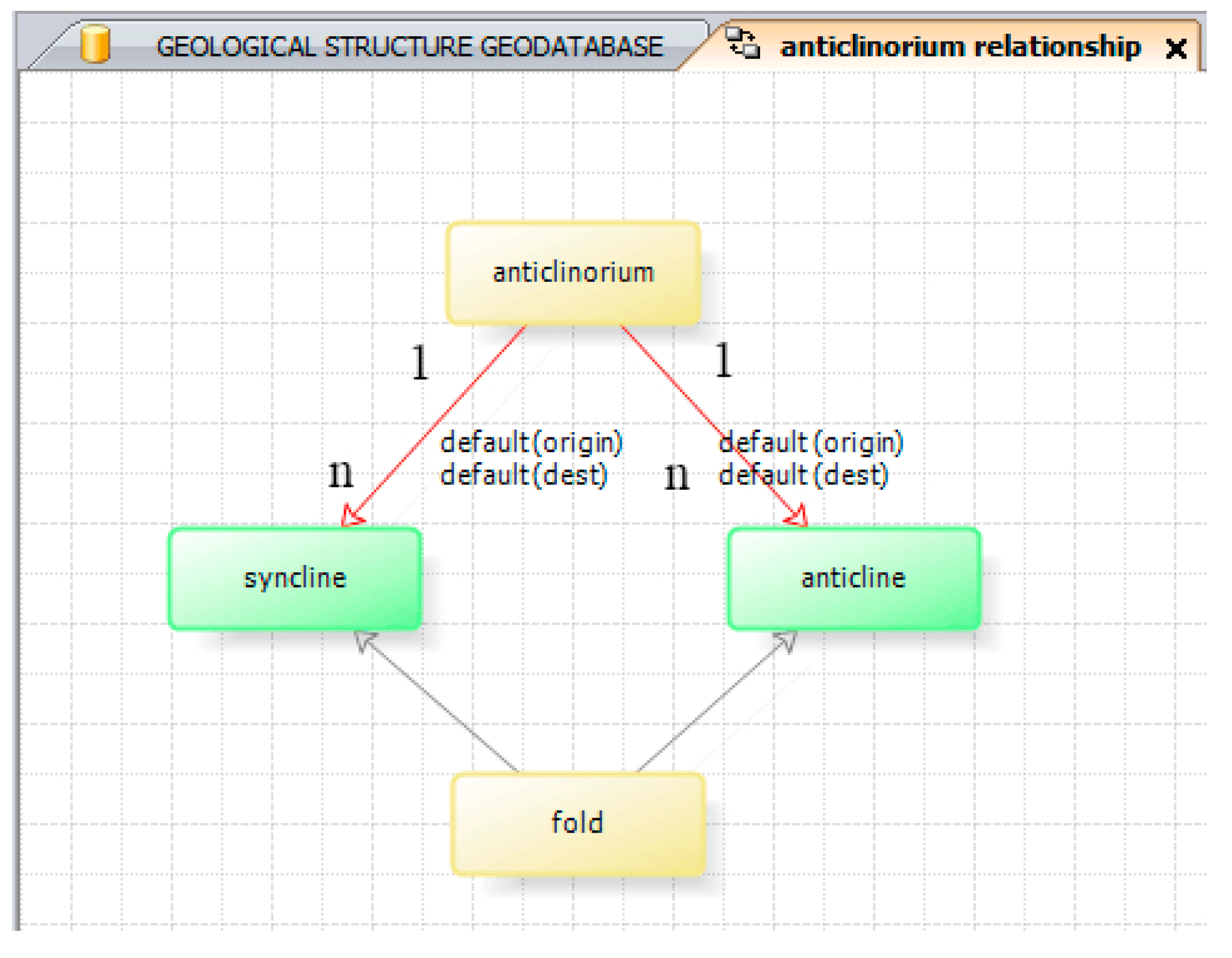
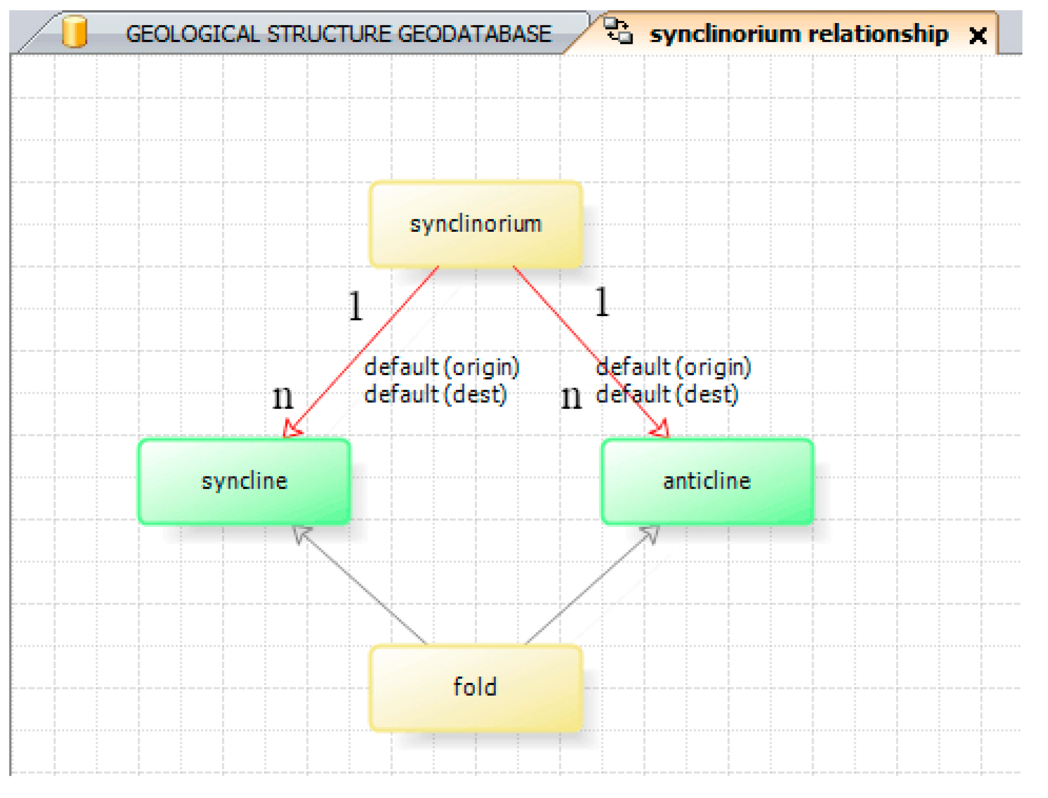
- Figure 14a shows the geometric expression of the anticlinorium. This model complies with the semantic description of the topological relationship that states “The anticlinorium is made up of some folds (syncline and anticline)” and the association rule of “one-to-many simple relationship”.
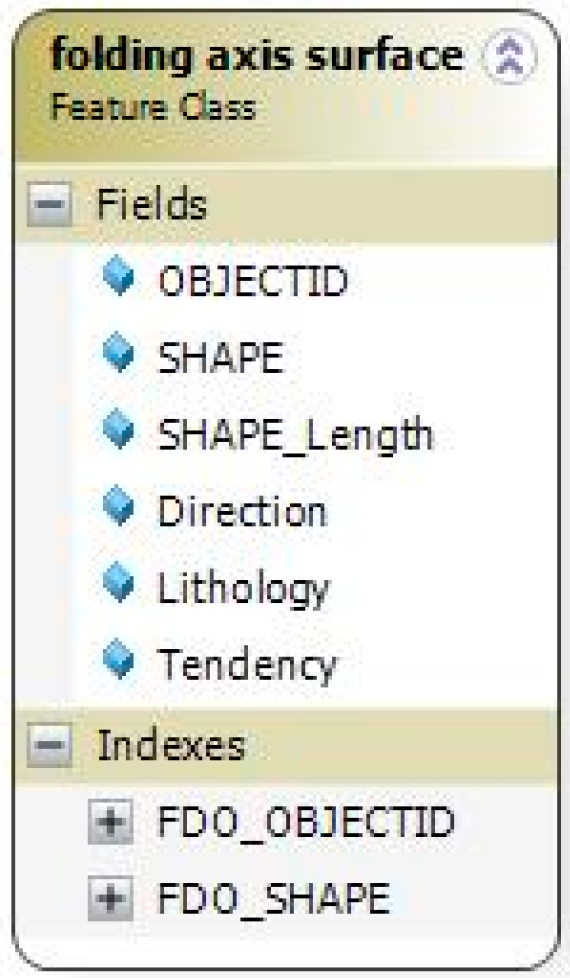
- Figure 14b shows the geometric expression of the folding axis. This model complies with the semantic description of the topological relationship that states “The axis cannot intersect with or be covered by the geological boundary”, that is, the topological rule of “must not self intersect”.
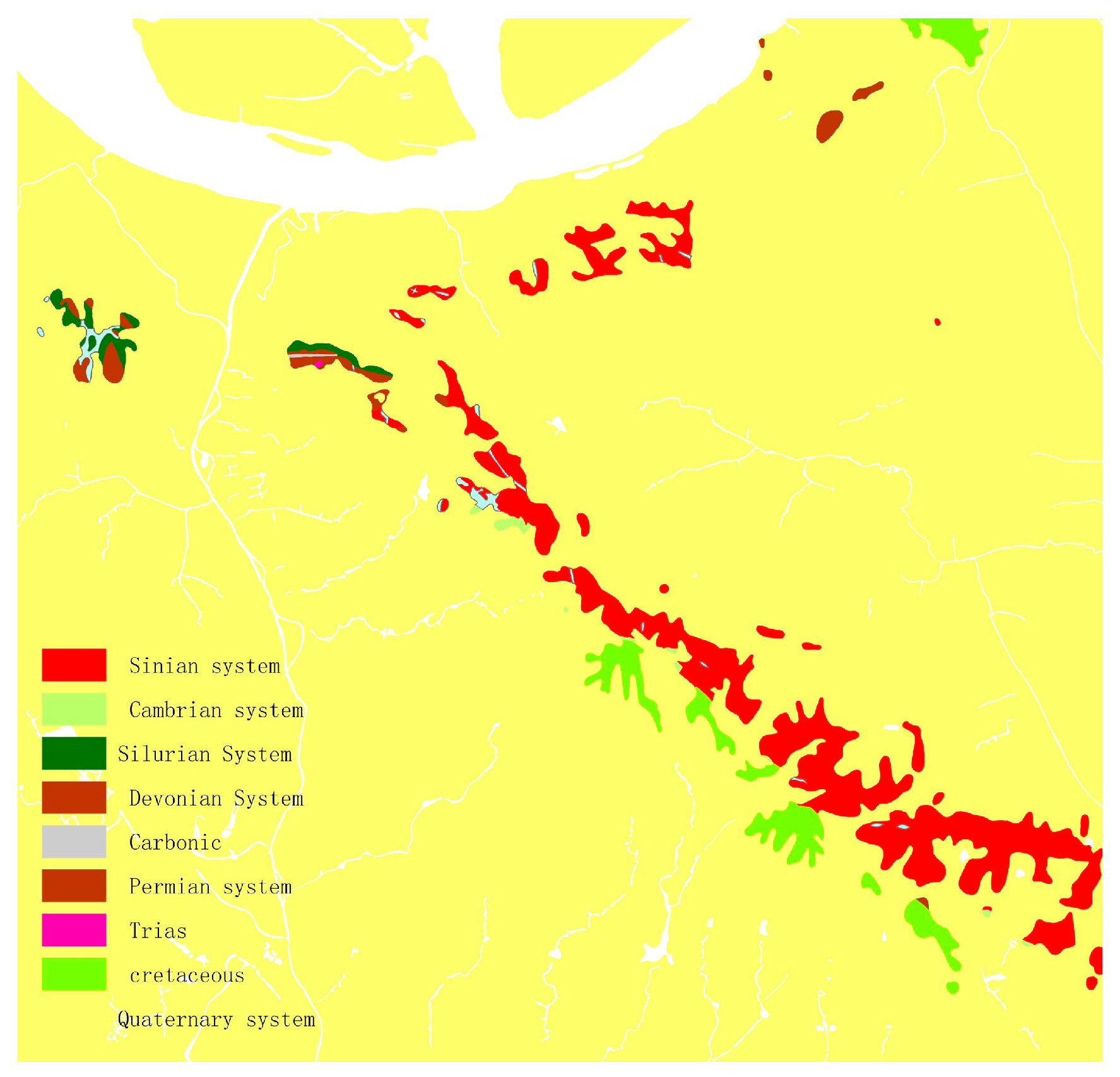
- Figure 14c shows the geometric expression of the conformable contact. This model complies with the semantic description of the topological relationship that states “The boundary of the conformable contact plane must be covered by the geological boundary”, that is, the topological rule of “Boundary must be covered by”.
- Figure 14d shows the geometric expression of faulted contact. This model complies with the semantic description of the topological relationship that states “The boundary of the rock contact plane must be covered by a faulted line”, that is, the topological rule of “Boundary must be covered by”.
5. Conclusions
- Based on the geological definitions, the model categorizes geological relationships as internal composition relationships and external combined relationships, resulting in a total of two categories, eight classes and 27 small groups.
- The corresponding descriptions of topological rules are designed for each composition relationship, and the corresponding descriptions of association rules are designed for each association relationship.
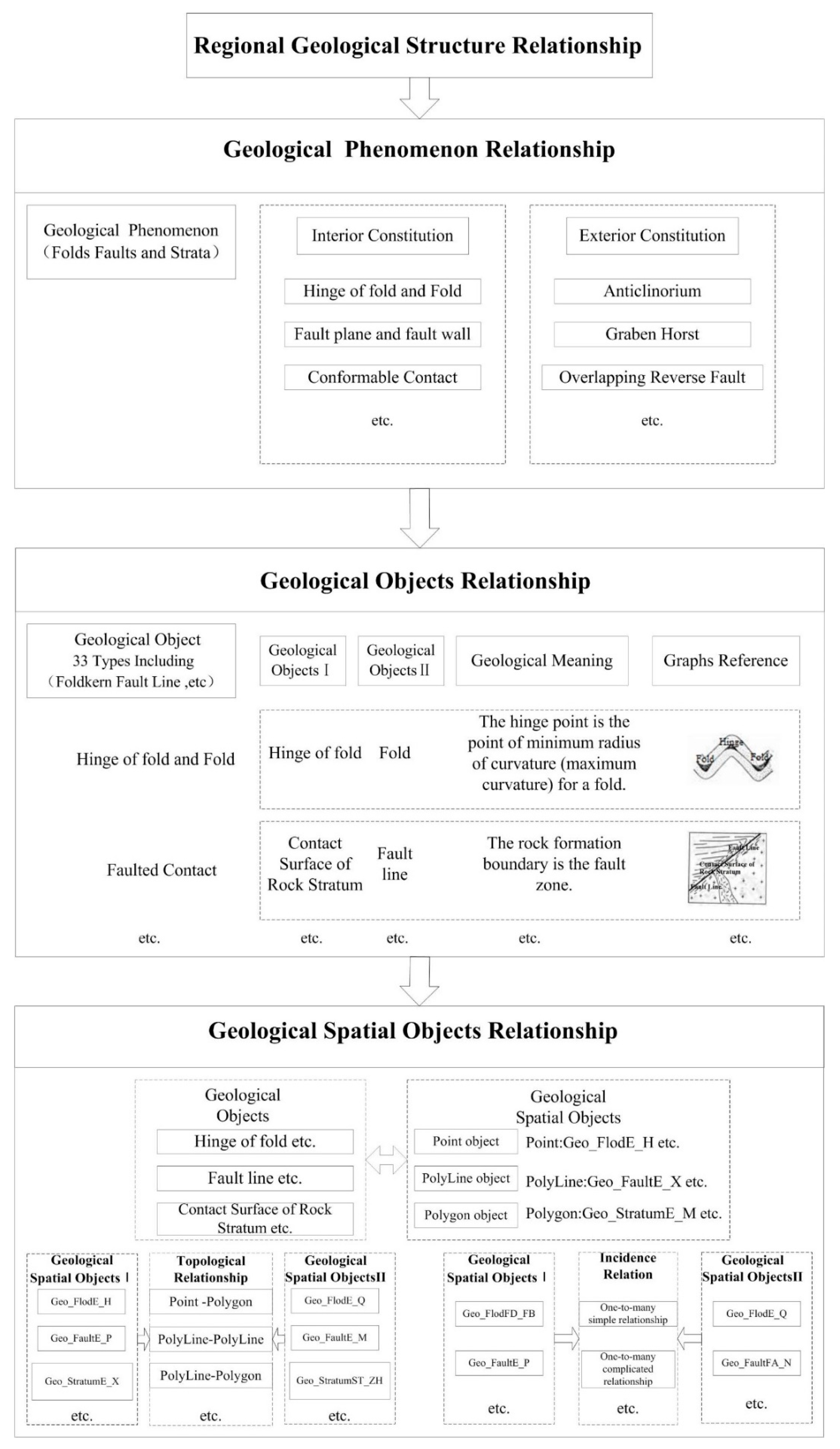
- The model then expresses the internal composition relationships as topological relationships between geological spatial objects, thereby defining the Origin, Dest and TopologyRuleType for each Topology Rule, and expresses the external position relationships (i.e., combined relationships) as association relationships between geological spatial objects, thereby defining the Origin, Dest and RelationRuleType for each Relationship Class.
- Define and classify the geological relationships. Explain the geological phenomena and their relationships based on their geological meanings.
- Generalize the three levels of geological relationships from geological phenomena to geological objects and geological spatial objects to construct their interior constitution expressions by topological relationships and their exterior constitution expressions by association relationships between spatial objects.
- According to this study, the developed model can express geological meanings and store geometric elements, and it can show the corresponding geological relationships well.
- Based on the relationship classification system of multiple tectonic scales (such as tectonics, regional structures, and microstructures), GIS modelling could be used to study the geological relationships at multiple dimensions and scales and unify the levels of spatial expression.
- Using the geological rules of geological relationships as the platform for recognition and judgement, the GIS model could be used to recognize and judge the relationships of complicated structures.
Author Contributions
Funding
Conflicts of Interest
References
- Wu, L.; Zhang, R.; Qi, Y. 3D geoscience modelling and virtual mine system. Acta Geod. Cartogr. Sin. 2002, 1, 28–33. [Google Scholar]
- Scheck-Wenderoth, M.; Lamarche, J. Crustal memory and basin evolution in the Central European Basin System—New insights from a 3D structural model. Tectonophysics 2005, 397, 143–165. [Google Scholar] [CrossRef]
- Qiang, W.; Hua, X. Three-dimensional geological modeling and its application in digital mine. Sci. China Earth Sci. 2013, 43, 1996–2006. [Google Scholar]
- Cheng, P.; Gong, J. Design of three-dimensional spatial datamodel and its data structure in geological exploration engineering. Acta Geod. Cartogr. Sin. 2001, 1, 74–81. [Google Scholar]
- Yu, J.; Wu, L.; Zi, G.; Guo, Z. SDOG-based multi-scale 3D modeling and visualization on global lithosphere. Sci. China Earth Sci. 2012, 5, 755–763. [Google Scholar] [CrossRef]
- Raiber, M.; White, P.A.; Daughney, C.J.; Tschritter, C.; Davidson, P.; Bainbridge, S.E. Three-dimensional geological modelling and multivariate statistical analysis of water chemistry data to analyse and visualize aquifer structure and groundwater composition in theWairau Plain, Marlborough District, New Zealand. J. Hydrol. 2012, 436, 13–34. [Google Scholar] [CrossRef]
- Natali, M.; Klausen, T.G.; Patel, D. Sketch-based modelling and visualization of geological deposition. Comput. Geosci. 2014, 67, 40–48. [Google Scholar] [CrossRef]
- Turner, A.K. Challenges and trends for geological modelling and visualisation. Bull. Eng. Geol. Environ. 2006, 65, 109–127. [Google Scholar] [CrossRef]
- Li, Z.; Pan, M.; Han, D. Three dimensional structural modeling technique. Earth Sci. 2016, 12, 2136–2146. [Google Scholar]
- Guo, J.; Wu, L.; Zhou, W.; Jiang, J.; Li, C. Towards automatic and topologically consistent 3D regional geological modeling from boundariesand attitudes. ISPRS Int. J. Geo-Inf. 2016, 5, 17. [Google Scholar] [CrossRef]
- Wang, R.-H.; Li, Y.-S. Introduction and determination of borderline virtual boreholes in 3D modeling of complicated geological bodies. Acta Geod. Cartogr. Sin. 2007, 4, 468–475. [Google Scholar]
- Li, Q.; Li, D. Reserch on the conceptual frame of the integration of 3D spatial data model. Acta Geod. Cartogr. Sin. 1998, 4, 325–330. [Google Scholar]
- Zhong, D.; Zhang, X.; Ao, X.; Wang, X.; Tong, D.; Ren, B. Study on coupled 3D seepage and stress fields of the complex channel project. Sci. China Technol. Sci. 2013, 11, 1193–1201. [Google Scholar] [CrossRef]
- Chen, X.; Wu, L.; Che, D. 3D modeling method of geological bodies including faults based on borehole data. Coal Geol. Explor. 2005, 33, 5–8. [Google Scholar]
- Zhang, S.; Zhou, C.; Zhang, J.; Chen, X. A ubiquitous knowledgeable data representation model (UKRM) for three-dimensional geographic information systems (3D GIS). Sci. China Earth Sci. 2016, 2, 214–228. [Google Scholar] [CrossRef]
- He, H.D. Research on Regional Geological Structure, Semantic Parsing and Object Modeling; Nanjing Normal University: Nanjing, China, 2014. (In Chinese) [Google Scholar]
- An, C.; Zhan, L.; Xinzhong, W. Automatic construction of topological relationship of 3D geological blocks based on stratified geological structure. Acta Geod. Cartogr. Sin. 2012, 1, 147–151. [Google Scholar]
- Wu, L.; Xu, L.; Che, D. Stratum-ontology and its application in borehole data integration. Geomat. Inf. Sci. Wuhan Univ. 2008, 2, 144–148. [Google Scholar]
- Du, Q.; Ren, F. Representation of spatial information in natural languag. Geomat. Inf. Sci. Wuhan Univ. 2014, 6, 682–688. [Google Scholar]
- Calcagno, P.; Chilès, J.P.; Courrioux, G.; Guillen, A. Geological modelling from field data and geological knowledge: Part I. Modelling method coupling 3D potential-field interpolation and geological rules. Phys. Earth Planet. Inter. 2008, 171, 147–157. [Google Scholar] [CrossRef]
- Wu, C.; He, Z.; Weng, Z. Property, classification and key technologies of three-dimensional geological data visualization. Geol. Bull. China 2011, 5, 642–649. [Google Scholar]
- Amorim, R.; Brazil, E.V.; Samavati, F.; Sousa, M.C. 3D geological modeling using sketches and annotations from geologic maps. In Proceedings of the 4th Joint Symposium on Computational Aesthetics, Non-Photorealistic Animation and Rendering, and Sketch-Based Interfaces and Modeling, New York, NY, USA, 8–10 August 2014. [Google Scholar]
- Zlatanova, S.; Rahman, A.; Shi, W. Topological models and frameworks for 3D spatial objects. Comput. Geosci. 2004, 30, 419–428. [Google Scholar] [CrossRef] [Green Version]
- Perrin, M.; Mastella, L.; Morel, O. Geological time formalization: An improved formal model for describing time successions and their correlation. Earth Sci. Inf. 2011, 11, 81–96. [Google Scholar] [CrossRef]
- Adaly, S.; Bouqata, B.; Marcus, A. A day in the life of a metamorphic. In Proceedings of the IEEE 29th International Conference on Data Engineering Workshops, Brisbane, Australia, 8–12 April 2013. [Google Scholar]
- Mastella, L.S.; Ait-Ameury, Y.; Jean, S. Semantic exploitation of persistent metadata in engineering models: Application to geological models. In Proceedings of the Third International Conference on Research Challenges in Information Science, Fez, Morocco, 22–24 April 2009. [Google Scholar]
- Hou, W.; Liu, X.; Wu, X. Geo-ontology logical structure and development technology for 3D geology modeling. Geogr. Geo-Inf. Sci. 2009, 1, 27–31. [Google Scholar]
- Yao, M.; Li, A.B.; Chen, Y.; Wu, C.Y. An automatic method for creating the geological boundary layer. J. Geo-Inf. Sci. 2017, 19, 326–335. [Google Scholar]
- Guo, J.; Wu, L.; Zhou, W. Automatic ore body implicit 3D modeling based on radial basis function surface. J. China Coal Soc. 2016, 8, 2130–2135. [Google Scholar]
- Li, W.J.; Shi, Y.L.; Hu, D. A geological map edge matching method based on considering attributes elements. Metal Mine 2017, 6, 132–136. [Google Scholar]
- Gong, J.; Li, X.; Wu, H. Spatiotemporal data model for real-time GIS. Acta Geod. Cartogr. Sin. 2014, 3, 226–232. [Google Scholar]
- Keßler, C.; Raubal, M.; Wosniok, C. Semantic rules for context-aware geographical information retrieval. In Proceedings of the 4th European Conference on Smart Sensing and Context, Guildford, UK, 16–18 September 2009; Springer: Guildford, UK, 2009. [Google Scholar]
- Bazire, M.; Brézillon, P. Understanding context before using it. In Modeling and Using Context; Dey, A., Kokinov, B., Leake, D., Turner, R., Eds.; Springer: Berlin/Heidelberg, Germany, 2005. [Google Scholar]
- China Geological Survey. DD2006-06, Digital Geological Map Database Standards; China Geological Survey: Beijing, China, 2006.
- Li, C.; Lv, X.; Liu, C.; Li, F.; Li, J.; Liu, Y. The architecture of geological survey intelligent space. Acta Geod. Cartogr. Sin. 2015, 1, 143–151. [Google Scholar]
- Lomotey, R.K.; Deters, R. Terms mining in document-based NoSQL: Response to unstructured data. In Proceedings of the 3rd IEEE International Congress on Big Data, BigData Congress, Anchorage, AK, USA, 27 June–2 July 2014. [Google Scholar]
- Sirsat, S.R.; Chavan, V.; Deshpande, S.P. Mining knowledge from text repositories using information extraction: A review. Sadhana 2014, 39, 53–62. [Google Scholar] [CrossRef]
- He, H.; Di, H.; Lu, G. GIS data modeling of a regional geological structure by integrating geometric and semantic expressions. Acta Geod. Cartogr. Sin. 2017, 8, 1058–1068. [Google Scholar]
- Wu, L.; Xue, L.; Li, C. A geospatial information grid framework for geological survey. PLoS ONE 2015, 10. [Google Scholar] [CrossRef] [PubMed]
- Hu, M.; Liao, T. Structural Geology; Petroleum Industry Press: Beijing, China, 2007. (In Chinese) [Google Scholar]
- Zeng, Z.X.; Fan, G.M. Structural Geology; China University of Geosciences Press: Wuhan, China, 2008. (In Chinese) [Google Scholar]
- Pollard, D.D.; Fletcher, R.C. Fundamentals of Structural Geology; Cambridge University: Cambridge, UK, 2005. [Google Scholar]
- Neville, J.P.; John, W.C. Analysis of Geological Structures; Cambridge University: Cambridge, UK, 1990. [Google Scholar]
- Davis, G.H.; Reynolds, S.J. Structural Geology of Rocks and Regions; John Wiley & Sons: Hoboken, NJ, USA, 1996. [Google Scholar]
- Zhang, X.Y.; Zhang, C.J.; Zhu, S.N. Annotation for geographical spatial relations in Chinese text. Acta Geod. Cartogr. Sin. 2012, 3, 468–474. [Google Scholar]
- Vockner, B.; Mittlböck, M. Geo-enrichment and semantic enhancement of metadata sets to augment discovery in geoportals. ISPRS Int. J. Geo-Inf. 2014, 3, 345–367. [Google Scholar] [CrossRef]
- Lu, G.; Yuan, L.; Yu, Z. Surveying and mapping geographical information from the perspective of geography. Acta Geod. Cartogr. Sin. 2017, 10, 1549–1556. [Google Scholar]
- Zhu, Q.; Hu, M. Semantics-based LOD models of 3D house property. Acta Geod. Cartogr. Sin. 2008, 4, 514–520. [Google Scholar]
- Zambelli, P.; Gebbert, S.; Ciolli, M. Pygrass: An object oriented python Application Programming Interface (API) for Geographic Resources Analysis Support System (GRASS) Geographic Information System (GIS). ISPRS Int. J. Geo-Inf. 2013, 2, 201–219. [Google Scholar] [CrossRef]
- Hu, Y.; Janowicz, K.; Prasad, S.; Gao, S. Enabling semantic search and knowledge discovery for arcgis online: A linked-data-driven. In Proceedings of the 18th AGILE International Conference on Geographic Information Science, AGILE 2015, Lisbon, Portugal, 9–12 June 2015; Kluwer Academic Publishers: Lisbon, Portugal, 2015. [Google Scholar]





| Geological Structure | Geological Meaning References [40,41,42,43,44] | Geological Phenomena |
|---|---|---|
| Folds | A geological fold occurs when one surface or a stack of originally flat and planar surfaces, such as sedimentary strata, are bent or curved as a result of permanent deformation. A set of folds distributed on a regional scale constitutes a fold belt, a common feature of orogenic zones. | Hinge of fold, limb of fold, folding axis line, folding axis surface, fold (syncline and anticline), anticlinorium, synclinorium, comb-like fold, wide-spaced synclines, linear fold, brachyaxis fold, structural dome and structural basin |
| Faults | A fault is a planar fracture or discontinuity in a volume of rock, across which there has been significant displacement along the fracture as a result of movements at the Earth’s surface. Large faults within the Earth’s crust result from plate tectonic forces; the largest faults form the boundaries between plates such as subduction zones or transform faults. | Fault plane (<45° and >45°), fault wall (hanging wall and foot wall), normal fault, reverse/thrust fault, wrench fault, longitudinal fault, transverse fault, diagonal fault, strike-slip fault, dip-slip fault, oblique fault and bedding fault |
| Strata | In geology and related fields, a stratum (plural: strata) is a layer of sedimentary rock or soil with internally consistent characteristics that distinguish it from other layers. The stratum is the fundamental unit in a stratigraphic column and forms the basis of the study of stratigraphy. | Geological boundary, rock formation boundary, fault line, stratum contact plane (conformable contact and unconformable contact), rock contact plane (intrusive rock, sedimentary rock and igneous rock), fault contact plane, chronostratigraphic element, and lithostratigraphic element |
| L1 | L2 | L3 | Geological Meaning References [40,41,42,43,44] | Graphs References [40,41,42,43,44] |
|---|---|---|---|---|
| Geological phenomena constituents | Fold elements | Hinge of fold | The hinge is where the flanks join together. The hinge point is the point of minimum radius (maximum curvature) along a fold. |  |
| Limb of fold | The limb of a fold is a portion of strata that is folded or bent into an anticline or syncline or that connects two horizontal or parallel portions of strata of different levels (as a monocline). The limbs are the flanks of the fold. | |||
| Folding axis line | The axial trace is the line of intersection of the axial surface with any other surface (i.e., the ground, side of a mountain, or geological cross-section). | |||
| Fault elements | Hanging wall | The hanging wall occurs above the fault plane. |  | |
| Foot wall | The footwall occurs below the fault plane. | |||
| Stratum elements | Conformable contact | The geological boundary lies along the conformable contact surface. |  | |
| Unconformable contact | The geological boundary lies along the unconformable contact surface. |  | ||
| Intrusive contact | The rock formation boundary slices the stratum. |  | ||
| Sedimentary contact | The stratum boundary slices the rock formation. |  | ||
| Faulted contact | The rock formation boundary is the fault zone. |  | ||
| Geological phenomena Combined forms | Fold and fold | Anticlinorium | A compound anticline consisting of a series of subordinate anticlines and synclines, where the whole structure has the general contour of an arch. |  |
| Synclinorium | A synclinorium (plural synclinoriums or synclinoria) is a large syncline with superimposed smaller folds. |  | ||
| Fold and stratum | Linear fold | The trend and plunge of linear features, such as the axis of a fold, describing the azimuth of the line and its deviation from the horizontal plane. |  | |
| Brachyaxis fold | In arched, fractured and block-type basins, open brachyanticlines often form. |  | ||
| Structural dome | An anticline structure whose aspect ratio is smaller than 3:1 |  | ||
| Structural basin | A syncline structure whose aspect ratio is smaller than 3:1 |  | ||
| Fault and fold | Longitudinal fault | Controlled by a structural trap, an orebody located in the core of a brachyanticline or a pitching part of a plunging anticline intersected by a high-angle longitudinal fault. |  | |
| Transverse fault | A transform fault or transform boundary is a plate boundary where the motion is predominantly horizontal. It ends abruptly and is connected to another transform fault, a spreading ridge, or a subduction zone. | |||
| Diagonal fault | A diagonal fault strikes obliquely or diagonally to the strike of the adjacent rocks. | |||
| Fault and fault | Horst and graben structure | Controlled by normal faults (growth faults), they assume the general characteristics of horst–graben or semihorst–semigraben structures. |  | |
| Imbricate reverse fault | Reverse faults with the same occurrence and hanging walls thrusting upwards successively. |  | ||
| Reverse/back-thrust fault | A tear fault intersected by a low-angle normal fault or thrust fault can form some traps, e.g., a trap-door structural trap. Two reverse faults with the same/different tendencies are accompanied by an anticline. |  | ||
| Conjugate fault | Made up of two groups of conjugate faults. |  | ||
| Fault and stratum | Strike-slip fault | In a strike-slip fault (also known as a wrench fault, tear fault or transcurrent fault), the fault surface (plane) is usually nearly vertical, and the footwall moves laterally (i.e., sinistrally or dextrally) with very little vertical motion. |  | |
| Dip-slip fault | Dip-slip faults can be either normal (extensional) or reverse. In a normal fault, the hanging wall moves downward relative to the footwall. A reverse fault is the opposite of a normal fault, i.e., the hanging wall moves up relative to the footwall. | |||
| Oblique fault | A fault that has a component of dip-slip and a component of strike-slip. | |||
| Bedding fault | A bedding fault is a fault plane parallel to the bedding. |
| Palette | Symbol | Graphics in Diagrammer | Diagrammer Meaning |
|---|---|---|---|
| Link mode |  |  | Red arrows describe “relationships”. Black arrows denote “contains”. |
| Feature classes |  |  | A collection of geographic features with the same polygon geometry, attributes, and spatial reference. |
| Dataset |  |  | A collection of geographic feature classes stored together that share the same spatial reference; that is, they share a coordinate system, and their features fall within a common geographic area. |
| Topology |  |  | The arrangement that constrains how point, line, and polygon features share a geometry. |
| Relationship |  |  | An item in Geodatabase that stores information about a relationship. |
| Subtype |  |  | A subset of feature class or objects in a table that share the same attributes. |
| Composition Relationships | Geological Rules | Meanings of Topological Rules Reference [38] | Graphs |
|---|---|---|---|
| Hinge of fold and Fold | Every fold hinge (Point) must be properly inside the fold (Polygon). | Point features from one layer must be properly contained inside the area features from another layer. |  |
| Folding axis line | No axis (Polyline) can intersect with or overlap another axis | A line feature from one layer must not intersect with itself. |  |
| Limb of fold and Fold | Every fold limb (Polyline) must be covered by the fold (Polygon) element boundary. | Line features from one layer must coincide with the boundaries of the area features of another layer. |  |
| Hanging wall and Fault plane | The boundary of a hanging wall (Polyline) must be covered by a fault plane (Polygon). | The boundaries of an area feature from one layer must be covered by the line features of another layer. |  |
| Foot wall and Fault plane | The boundary of a foot wall (Polyline) must be covered by a fault plane (Polygon). | The boundaries of an area feature from one layer must be covered by the line features of another layer. |  |
| Conformable contact | The boundary of a conformable contact (Polyline) must be covered by a geological boundary (Polygon). | The boundaries of an area feature from one layer must be covered by the line features of another layer. |  |
| Unconformable contact | The boundary of an unconformable contact (Polyline) must be covered by a geological boundary (Polygon). | The boundaries of an area feature from one layer must be covered by the line features of another layer. |  |
| Intrusive contact | The boundary of a stratum contact (Polyline) must be covered by a rock boundary (Polygon). | The boundaries of an area feature from one layer must be covered by the line features of another layer. |  |
| Sedimentary contact | The boundary of a rock contact (Polyline) plane must be covered a geological boundary (Polygon). | The boundaries of an area feature from one layer must be covered by the line features of another layer. |  |
| Faulted contact | The boundary of a planar rock contact (Polyline) must be covered by a faulted line (Polygon). | The boundaries of an area feature from one layer must be covered by the line features of another layer. |  |
| L1 | L2 | L3 | Origin Class | Destination Class | Association Rule |
|---|---|---|---|---|---|
| Association relationship of geological phenomena | Fold and fold | Anticlinorium | Anticlinorium | Fold | One-to-many simple relationship |
| synclinorium | synclinorium | Fold | One-to-many simple relationship | ||
| Fold and stratum | Linear fold | Linear fold | Stratum contact plane | One-to-many simple relationship | |
| Brachyaxis fold | Brachyaxis fold | Stratum contact plane | One-to-many simple relationship | ||
| Structural dome | Structural dome | Stratum contact plane | One-to-many simple relationship | ||
| Structural basin | Structural basin | Stratum contact plane | One-to-many simple relationship | ||
| Fault and fold | Longitudinal fault | Longitudinal fault | Folding axis | One-to-one simple relationship | |
| Transverse fault | Transverse fault | Folding axis | One-to-one simple relationship | ||
| Diagonal fault | Diagonal fault | Folding axis | One-to-one simple relationship | ||
| Fault and fault | Horst and graben structure | Fault wall | Normal fault | One-to-many complicated relationship | |
| Imbricate reverse fault | Hanging wall | Reverse fault | One-to-many complicated relationship | ||
| Reverse/back-thrust fault | Anticline | Reverse fault | One-to-many simple relationship | ||
| Conjugate fault | Wrench fault | Stratum line | One-to-many simple relationship | ||
| Fault and stratum | Strike-slip fault | Strike-slip fault | Rock formation contact plane | One-to-many simple relationship | |
| Dip-slip fault | Dip-slip fault | Rock formation contact plane | One-to-many simple relationship | ||
| Oblique fault | Oblique fault | Rock formation contact plane | One-to-many simple relationship | ||
| Bedding fault | Bedding fault | Rock formation contact plane | One-to-many simple relationship |
© 2018 by the authors. Licensee MDPI, Basel, Switzerland. This article is an open access article distributed under the terms and conditions of the Creative Commons Attribution (CC BY) license (http://creativecommons.org/licenses/by/4.0/).
Share and Cite
He, H.; Hu, D.; Lü, G. GIS Application to Regional Geological Structure Relationship Modelling Considering Semantics. ISPRS Int. J. Geo-Inf. 2018, 7, 267. https://doi.org/10.3390/ijgi7070267
He H, Hu D, Lü G. GIS Application to Regional Geological Structure Relationship Modelling Considering Semantics. ISPRS International Journal of Geo-Information. 2018; 7(7):267. https://doi.org/10.3390/ijgi7070267
Chicago/Turabian StyleHe, Handong, Di Hu, and Guonian Lü. 2018. "GIS Application to Regional Geological Structure Relationship Modelling Considering Semantics" ISPRS International Journal of Geo-Information 7, no. 7: 267. https://doi.org/10.3390/ijgi7070267
APA StyleHe, H., Hu, D., & Lü, G. (2018). GIS Application to Regional Geological Structure Relationship Modelling Considering Semantics. ISPRS International Journal of Geo-Information, 7(7), 267. https://doi.org/10.3390/ijgi7070267


