Comic Strip Narratives in Time Geography


Abstract

1. Introduction
1.1. Cartography and Art
- -
- Linking the artistic with the conventional map (“anti-map/map”).
- -
- The artist develops their own vision in relation to the conventional map.
- -
- Integrating the methods and techniques of artists into conventional maps. This is the approach put forward in this paper using the practice of comic book artists.
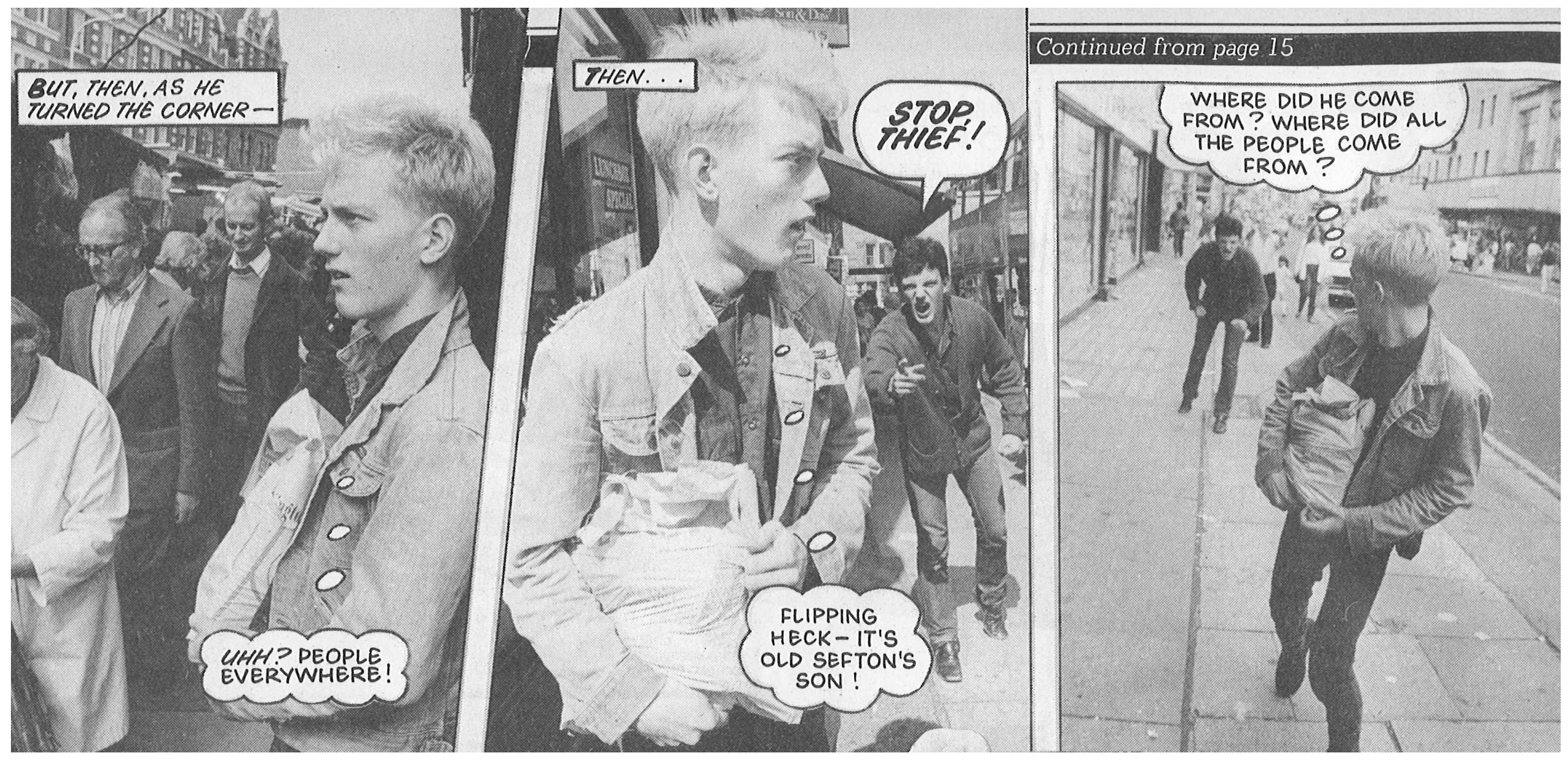
1.2. Comics and Art
2. Narratives, Comics and Maps
3. Comic Snapshots Embedded in the Map
3.1. Initial Thoughts
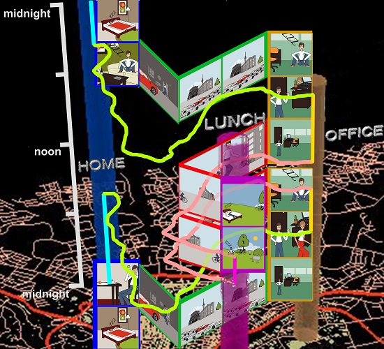
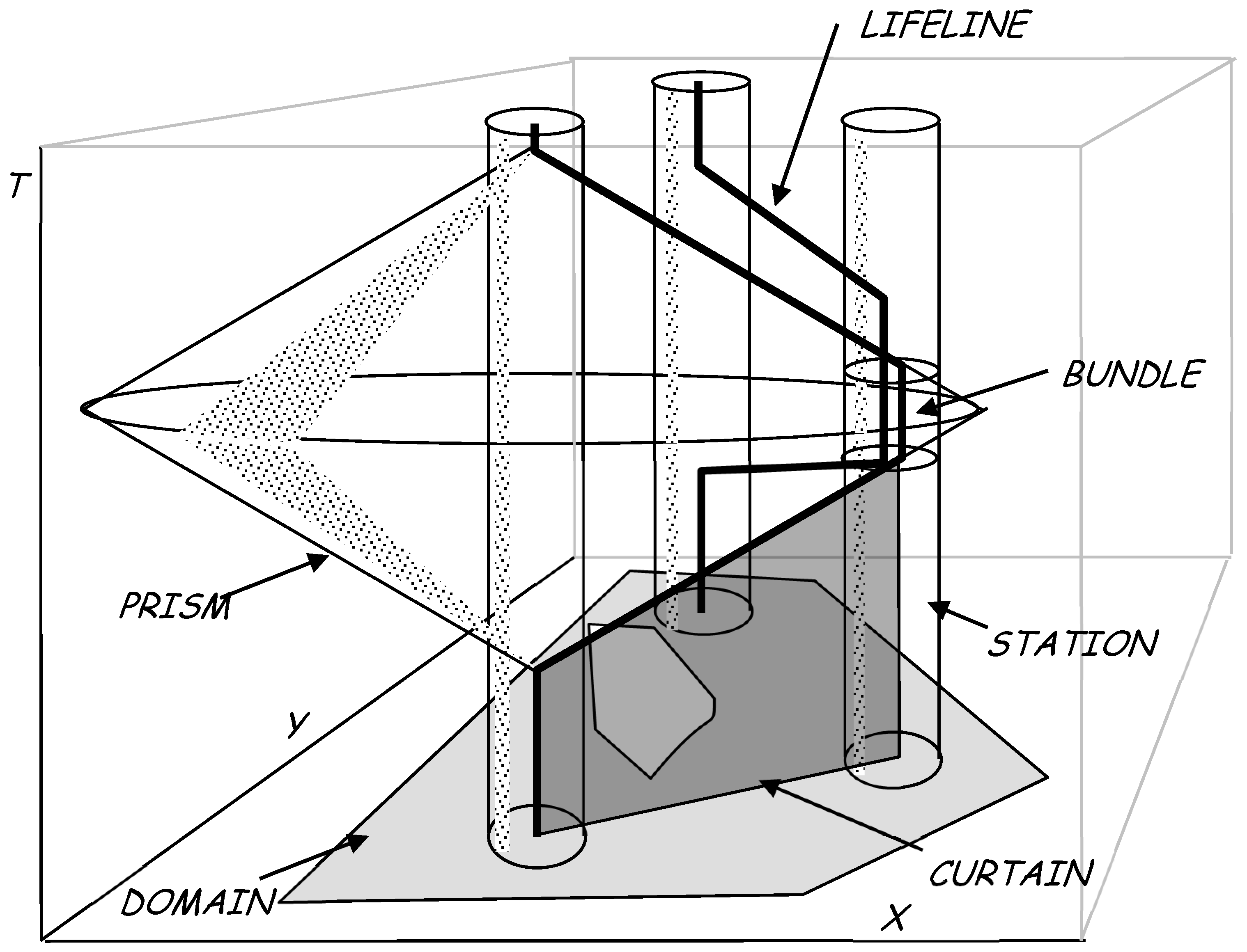
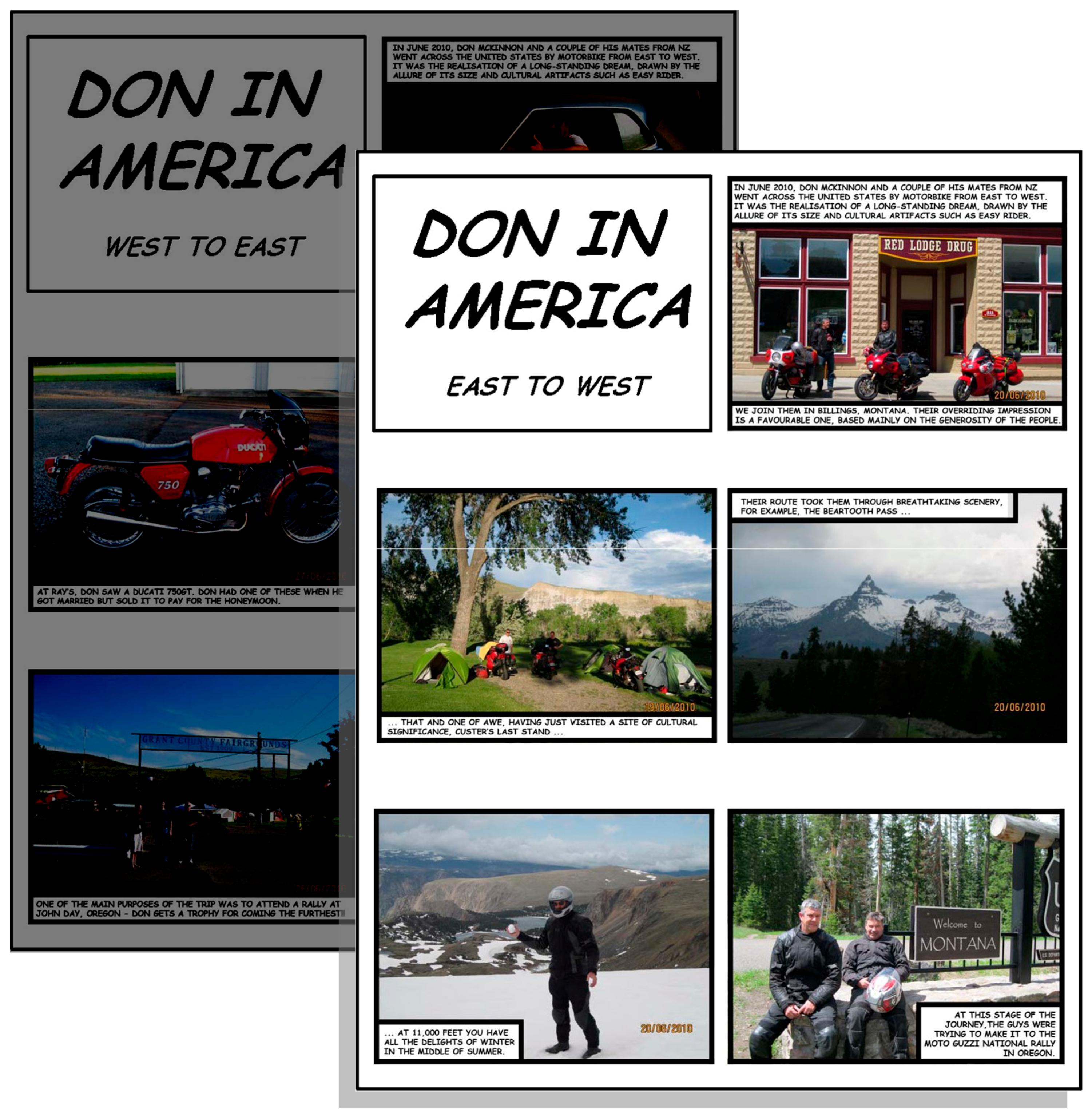
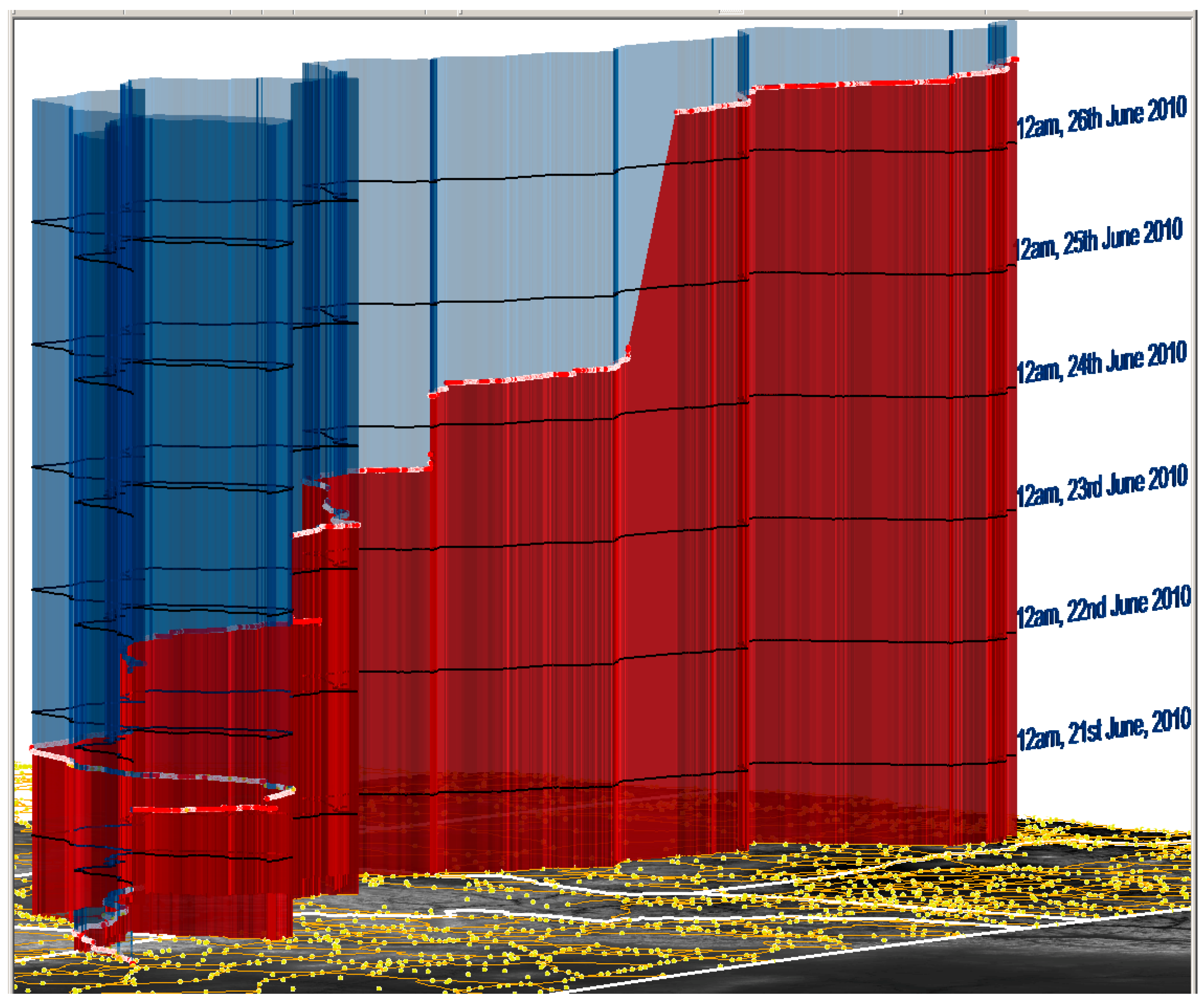
3.2. A Comic Lifeline Strip in a Space-Time Cube
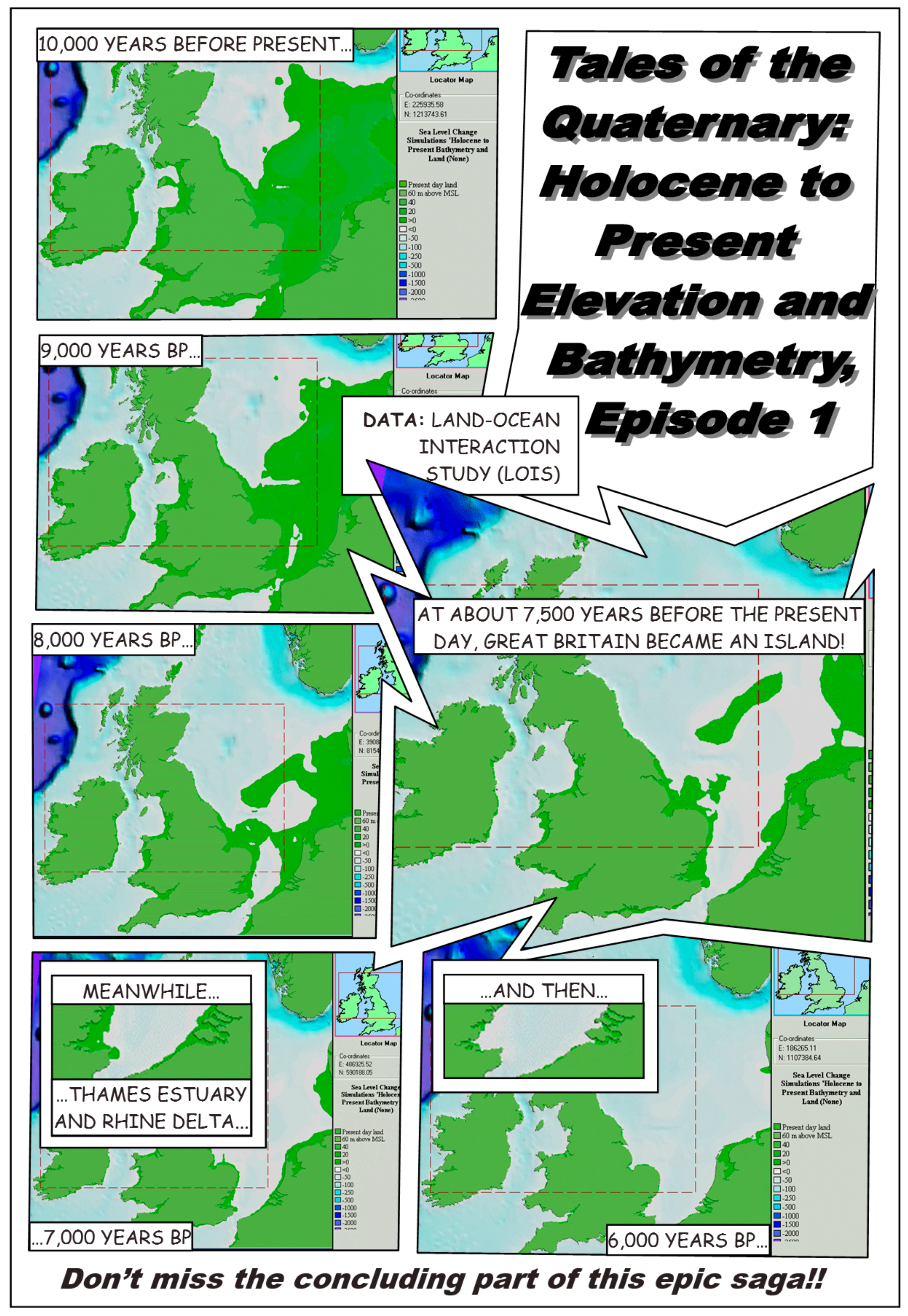
3.3. A Photographic Lifeline Strip in a Space-Time Cube
3.3.1. Context
3.3.2. Approach and Methods
4. Discussion
4.1. Snapshots and Sequential Art
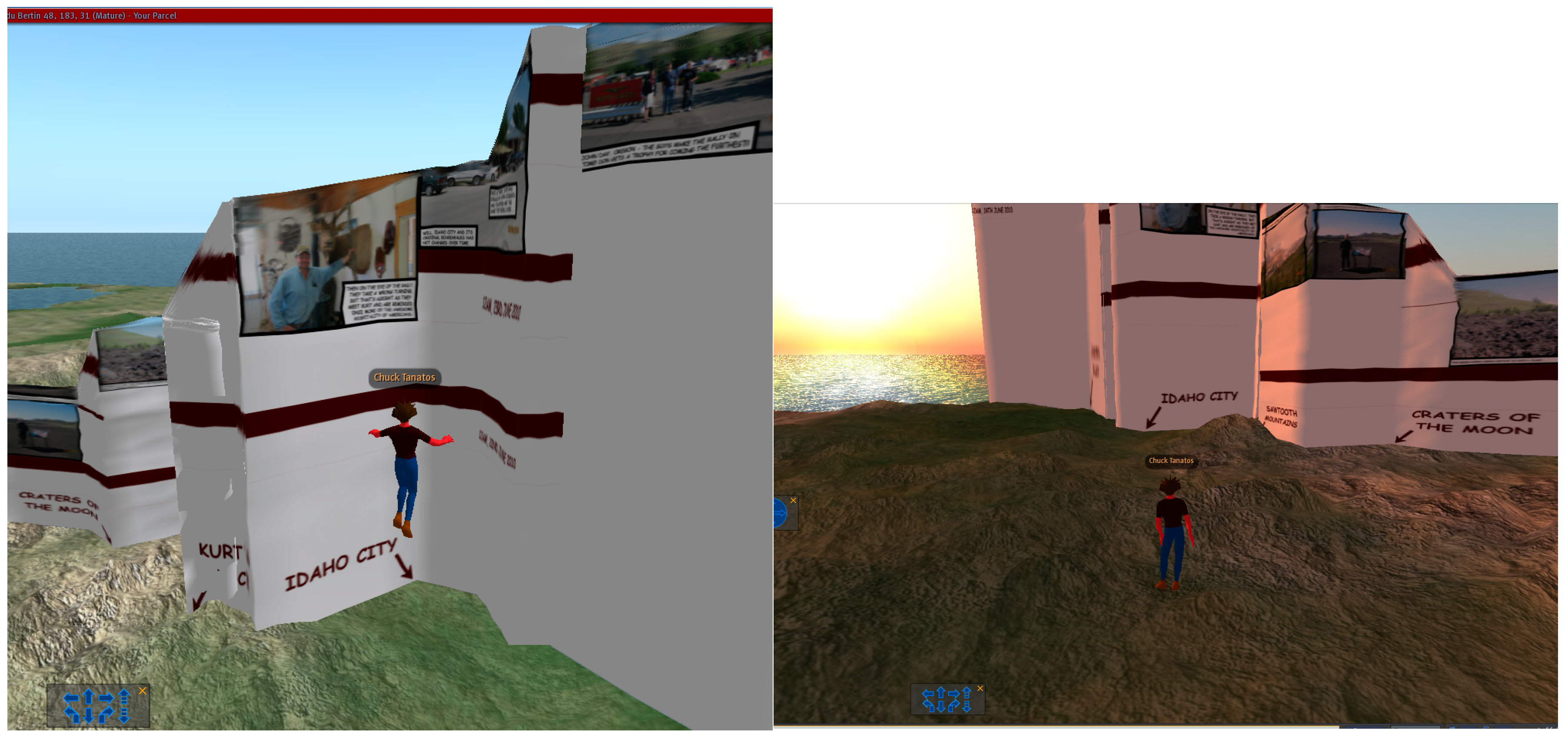
4.2. Immersive Virtual Environments and Testing
5. Conclusions
Author Contributions
Funding
Acknowledgments
Conflicts of Interest
References
- Aitken, S.; Craine, J. Guest editorial: Affective geovisualizations. Directions Magazine. 8 February 2006. Available online: http://www.directionsmag.com/articles/guest-editorial-affective-geovisualizations/123211 (accessed on 21 June 2018).
- Dodge, M.; Perkins, C.; Kitchin, R. Mapping modes, methods and moments: A manifesto for map studies. In Rethinking Maps: New Frontiers of Cartographic Theory; Dodge, M., Kitchin, R., Perkins, C., Eds.; Routledge: Abingdon, UK, 2009; pp. 220–243. [Google Scholar]
- Kwan, M.-P. From oral histories to visual narratives: Re-presenting the post-September 11 experiences of the Muslim women in the USA. Soc. Cult. Geogr. 2008, 9, 653–669. [Google Scholar] [CrossRef]
- Nold, C. Emotional Cartography: Technologies of the Self. 2009. Available online: www.emotionalcartography.net (accessed on 21 June 2018).
- Caquard, S.; Cartwright, W. Narrative Cartography: From Mapping Stories to the Narrative of Maps and Mapping. Cartogr. J. 2014, 51, 101–106. [Google Scholar] [CrossRef]
- Tasker, N. Chairman’s message. The Society of Cartographers Newsletter, July 1999; 1. [Google Scholar]
- Caquard, S. Cartography I: Mapping narrative cartography. Prog. Hum. Geogr. 2011, 37, 135–144. [Google Scholar] [CrossRef]
- Amoroso, N. The Exposed City: Mapping the Urban Invisibles; Routledge: New York, NY, USA, 2010. [Google Scholar]
- Cartwright, W. Extending the map metaphor using web-delivered multimedia. Int. J. Geogr. Inf. Sci. 1999, 13, 335–353. [Google Scholar] [CrossRef]
- MacFarlane, R. The Wild Places; Granta Books and Penguin Books: London, UK, 2007. [Google Scholar]
- Cartwright, W.; Field, K. Exploring cartographic storytelling. Reflections on mapping real-life and fictional stories. In Proceedings of the 27th International Cartographic Conference, Rio de Janiero, Brazil, 23–28 August 2015. [Google Scholar]
- Coulis, M. Hermeneut on a bike: Eleven geo-logical lessons in love and landscapes. In Expanding the Boundaries of Cartography: Journeys Beyond the Neatline; Rangel, M.J., Coulis, M.J., Jones, D.L., Eds.; University of Alberta Libraries: Edmonton, AB, Canada, 2010. [Google Scholar]
- Caquard, S.; Fiset, J.-P. How can we map stories? A cybercartographic application for narrative cartography. J. Maps 2014, 10, 18–25. [Google Scholar] [CrossRef]
- Robinson, A.C.; Demsar, U.; Moore, A.B.; Buckley, A.; Jiang, B.; Field, K.; Kraak, M.-J.; Camboim, S.P.; Sluter, C.R. Geospatial big data and cartography: Research challenges and opportunities for making maps that matter. Int. J. Cartogr. 2017, 3 (Suppl. 1), 32–60. [Google Scholar] [CrossRef]
- Casey, E.S. Earth-Mapping: Artists Reshaping Landscape; University of Minnesota Press: Minneapolis, MN, USA, 2005. [Google Scholar]
- Cartwright, W. Art and Cartographic Communication. In Cartography and Art; Cartwright, W., Gartner, G., Lehn, A., Eds.; Springer: Berlin, Germany, 2009; pp. 9–22. [Google Scholar]
- Caquard, S.; Taylor, D.R.F. Art, Maps and Cybercartography: Stimulating Reflexivity among Map-Users. In Cybercartography: Theory and Practice; Taylor, D.R.F., Ed.; Elsevier: Amsterdam, The Netherlands, 2005; pp. 285–307. [Google Scholar]
- Priestnall, G.; Hampson, D. Landscape Visualization: Science and Art. In Geographic Visualization; Dodge, M., McDerby, M., Turner, M., Eds.; John Wiley: New York, NY, USA, 2008; pp. 241–258. [Google Scholar]
- Krygier, J.B. Cartography as an art and a science? Cartogr. J. 1995, 32, 3–10. [Google Scholar] [CrossRef]
- McCloud, S. Reinventing Comics; Harper Collins: New York, NY, USA, 2000. [Google Scholar]
- Cartwright, W. Interactive multimedia for mapping. In Visualisation in Modern Cartography; MacEachren, A., Taylor, D.R.F., Eds.; Academic Press: Oxford, UK, 1994; pp. 63–89. [Google Scholar]
- Dix, A.; Finlay, J.; Abowd, G.D.; Beale, R. Human-Computer Interaction, 3rd ed.; Prentice Hall: Upper Saddle River, NJ, USA, 2004. [Google Scholar]
- Riedl, A. State-of-the-art of tactile hyperglobes. In True-3D in Cartography; Buchroithner, M., Ed.; Springer: Berlin, Germany, 2012; pp. 215–226. [Google Scholar]
- Thöny, M.; Schnürer, R.; Sieber, R.; Hurni, L.; Pajarola, R. Storytelling in Interactive 3D Geographic Visualization Systems. Int. J. Geo-Inf. 2018. [Google Scholar] [CrossRef]
- McCloud, S. Understanding Comics; Harper Collins: New York, NY, USA, 1993. [Google Scholar]
- Groensteen, T. The System of Comics; University Press of Mississippi: Jackson, MS, USA, 2009. [Google Scholar]
- Gershon, N.; Page, W. What Storytelling can do for Information Visualization. Commun. ACM 2001, 44, 31–37. [Google Scholar] [CrossRef]
- Wolk, D. Reading Comics: How Graphic Novels Work and What They Mean; Da Capo Press: Cambridge, MA, USA, 2007. [Google Scholar]
- Eisner, W. Comics and Sequential Art; Poorhouse Press: Tamarac, FL, USA, 1985. [Google Scholar]
- Horrocks, D. Inventing Comics. 2001. Available online: www.hicksville.co.nz/Inventing%20Comics.htm (accessed on 5 May 2018).
- Jones, C. Geographical Information Systems and Computer Cartography; Longman: London, UK, 1997. [Google Scholar]
- Moore, A. Cubes, shadows and comic strips—A.k.a. Interfaces, metaphors and maps? In SIRC 2004: A Spatio-Temporal Workshop, Proceedings of the 16th Annual Colloquium of the Spatial Information Research Centre; Whigham, P.A., McLennan, B.R., Eds.; University of Otago: Dunedin, New Zealand, 2004; pp. 97–102. [Google Scholar]
- Tufte, E. The Visual Display of Quantitative Information, 2nd ed.; Graphics Press: Cheshire, CT, USA, 2001. [Google Scholar]
- Sousanis, N. Unflattening; Harvard University Press: Cambridge, MA, USA, 2015. [Google Scholar]
- Monmonier, M. Authoring Graphic Scripts: Experiences and Principles. Cartogr. Geogr. Inf. Syst. 1991, 19, 247–260, 272. [Google Scholar] [CrossRef]
- Segel, E.; Heer, J. Narrative Visualization: Telling Stories with Data. IEEE Trans. Vis. Comput. Graph. 2010, 16, 1139–1148. [Google Scholar] [CrossRef] [PubMed]
- Zhao, Z.; Marr, R.; Elmqvist, N. Data Comics: Sequential Art for Data-Driven Storytelling; Technical Report; Human Computer Interaction Lab, University of Maryland: College Park, MD, USA, 2015. [Google Scholar]
- Thomas, F.; Johnston, O. Disney Animation: The Illusion of Life; Abbeville Press: New York, NY, USA, 1981. [Google Scholar]
- Horrocks, D. The Perfect Planet: Comics, Games and World-Building. In Writing at the Edge of the Universe: Essays Arising from the “Creative Writing in New Zealand” Conference; Williams, M., Ed.; University of Canterbury Press: Christchurch, New Zealand, 2004; pp. 197–223. [Google Scholar]
- Horrocks, D. ATLAS. 2008. Available online: http://www.hicksville.co.nz/Atlas.htm (accessed on 5 May 2018).
- Van Swaaij, L.; Klare, J. The Atlas of Experience; Bloomsbury: London, UK, 2000. [Google Scholar]
- Marmon Silko, L. Yellow Woman and a Beauty of the Spirit: Essays on Native American Life Today; Interior and Exterior Landscapes: The Pueblo Migration Stories; Simon and Schuster: New York, NY, USA, 1996; pp. 25–47. [Google Scholar]
- Moore, S.A.; Roth, R.E.; Rosenfeld, H.; Nost, E.; Vincent, K.; Arefin, M.R.; Buckingham, T.M.A. Undisciplining environmental justice research with visual storytelling. GeoForum 2017. [Google Scholar] [CrossRef]
- Cheshire, J.; Uberti, O. Where the Animals Go; Norton: New York, NY, USA, 2017. [Google Scholar]
- Reuschel, A.; Hurni, L. Mapping Literature: Visualisation of Spatial Uncertainty in Fiction. Cartogr. J. 2011, 48, 293–308. [Google Scholar] [CrossRef]
- Paelke, V.; Elias, B. Stories as Route Descriptions. In Spatial Information Theory–COSIT 2007; Winter, S., Duckham, M., Kulik, L., Kuipers, B., Eds.; Lecture Notes in Computer Science 4736; Springer: Berlin, Germany, 2007; pp. 255–267. [Google Scholar]
- Rich, C.; Waters, R.C.; Strohecker, C.; Schabes, Y.; Freeman, W.T.; Torrance, M.C.; Golding, A.R.; Roth, M. Demonstration of an Interactive Multimedia Environment. Computer 1994, 27, 15–22. [Google Scholar] [CrossRef]
- Hägerstrand, T. What about people in spatial science? Pap. Reg. Sci. Assoc. 1970, 24, 7–21. [Google Scholar] [CrossRef]
- Cron, J.; Wiesmann, S.; Hurni, L. Facilitating the Handling of Interactive Atlases by Dynamic Grouping of Functions–The Example of “Smart Legend”. In Geospatial Vision: New Dimensions in Cartography; Moore, A., Drecki, I., Eds.; Springer: Berlin, Germany, 2008; pp. 1–18. [Google Scholar]
- Platt, C. Interactive Entertainment. WIRED 1995, 3, 9. [Google Scholar]
- Roth, R.E.; Ross, K.S.; MacEachren, A.M. User-Centred Design for Interactive Maps: A Case Study in Crime Analysis. Int. J. Geo-Inf. 2015, 4, 262–301. [Google Scholar] [CrossRef]
- Mayr, E.; Windhager, F. Once upon a Spacetime: Visual Storytelling in Cognitive and Geotemporal Information Spaces. Int. J. Geo-Inf. 2018. [Google Scholar] [CrossRef]
- Kraak, M.J.; Kveladze, I. Narrative of the annotated Space—Time Cube—Revisiting a historical event. J. Maps 2017, 13, 56–61. [Google Scholar] [CrossRef]
- Bach, B.; Dragicevic, P.; Archambault, D.; Hurter, C.; Carpendale, S.A. Descriptive Framework for Temporal Data Visualizations Based on Generalized Space-Time Cubes. Comput. Graph. Forum 2016, 36, 36–61. [Google Scholar] [CrossRef]
- Hartung, F.; Burke, M.; Hagoort, P.; Willems, R.M. Taking perspective: Personal pronouns affect experiential aspects of literary reading. PLoS ONE 2016, 11, e0154732. [Google Scholar] [CrossRef] [PubMed]
- Spierling, U. Digital storytelling. Comput. Graph. 2002, 26, 1–2. [Google Scholar] [CrossRef]
- Danilicheva, P.; Klimenko, S.; Baturin, Y.; Serebrov, A. Education in Virtual Worlds: Virtual Storytelling. In Proceedings of the International Conference on CyberWorlds, Bradford, UK, 7–11 September 2009; pp. 333–338. [Google Scholar]
- Shaw, J. Legible City, digital dialogues. TEN 1991, 8, 46–47. [Google Scholar]
- Chew, C.Y.; Moore, A.; Chong, A.K. A Strategy for Space-Time Data Collection, Processing and Representation on Complex Transportation Networks. In Proceedings of the GeoCart 2006, Auckland, New Zealand, 4–6 September 2006; Drecki, I., Ed.; University of Auckland: Auckland, New Zealand, 2007; pp. 111–123. [Google Scholar]
- Cohn, N. Navigating comics: An empirical and theoretical approach to strategies of reading comic page layouts. Front. Psychol. 2013, 4, 186. [Google Scholar] [CrossRef] [PubMed]
- Pixton, T.M. PixtonTM—Comic Strip Creator—Make Your Own Web Comics Online. 2018. Available online: http://pixton.com/uk/ (accessed on 5 May 2018).
- Langran, G. Time in Geographic Information Systems; Taylor and Francis: London, UK, 1992. [Google Scholar]
- Kraak, M. The Space-Time Cube Revisited from a Geovisualisation Perspective. In Proceedings of the 21st International Cartographic Conference (ICC), Durban, South Africa, 10–16 August 2003; pp. 1988–1996. [Google Scholar]
- Eccles, R.; Kapler, T.; Harper, R.; Wright, W. Stories in GeoTime. Inf. Vis. 2008, 7, 3–17. [Google Scholar] [CrossRef]
- Plaisant, C.; Milash, B.; Rose, A.; Widoff, S.; Shneiderman, B. LifeLines: Visualizing personal histories. In Proceedings of the CHI ’96, Vancouver, BC, Canada, 13–18 April 1996; ACM: New York, NY, USA, 1996; pp. 221–227. [Google Scholar]
- Gemmell, J.; Bell, G.; Lueder, R.; Drucker, S.; Wong, C. MyLifeBits: Fulfilling the memex vision. In Proceedings of the ACM Multimedia ’02, Juan-les-Pins, France, 1–6 December 2002; ACM: New York, NY, USA, 2002; pp. 235–238. [Google Scholar]
- Caquard, S.; Wright, B. Challenging the Digital Cartographic Continuity System: Lessons from Cinema. In Cartography and Art; Cartwright, W., Gartner, G., Lehn, A., Eds.; Springer: Berlin, Germany, 2009; pp. 193–206. [Google Scholar]
- Simon, H. Models of Man; Wiley: Hoboken, NJ, USA, 1957. [Google Scholar]
- Hägerstrand, T. Migration and area. In Migration in Sweden, Lund studies in Geography; Series B, Human Geography, No. 13; Department of Geography, University of Lund: Lund, Sweden, 1957; pp. 27–158. [Google Scholar]
- Weber-Reuschel, A.-K.; Piatti, B.; Hurni, L. Data-Driven Expansion of Dense Regions—A Cartographic Approach in Literary Geography. Cartogr. J. 2014, 51, 123–140. [Google Scholar] [CrossRef]
- Laurini, R.; Thompson, D. Fundamentals of Spatial Information Systems; Academic Press: Waltham, MA, USA, 1992. [Google Scholar]
- Fabrikant, S.I. Visualizing region and scale in information spaces. In Proceedings of the 20th International Cartographic Conference (ICC 2001), Beijing, China, 6–10 August 2001; pp. 2522–2529. [Google Scholar]
- Russwurm, M.; Moore, A. “Visualising the project landscape”—A spatialisation describing workload attributes as terrain. Environ. Earth Sci. 2015, 74, 7159–7172. [Google Scholar] [CrossRef]
- Inception Ending. FastCoDesign—2010 Inception Infographic by Daniel Wang. 2010. Available online: http://www.inceptionending.com/theory/2010-inception-infographic-by-daniel-wang/ (accessed on 8 June 2018).
- Shennan, I.; Lambeck, K.; Flather, R.; Horton, B.; McArthur, J.; Innes, J.; Lloyd, J.; Rutherford, M.; Wingfield, R. Modelling western North Sea palaeogeographies and tidal changes during the Holocene. In Holocene Land-Ocean Interaction and Environmental Change around the North Sea; Shennan, I., Andrews, J., Eds.; Geological Society of London Special Publication: London, UK, 2000; pp. 299–319. [Google Scholar]
- Land Ocean Interaction Study (LOIS). LOIS Overview CDROM, version 2.0; Windows, Natural Environment Research Council (NERC): Swindon, UK, 2000. [Google Scholar]
- Gabbard, J.L.; Hix, D.; Swan, J.E. User-centered design and evaluation of virtual environments. IEEE Comput. Graph. Appl. 1999, 19, 51–59. [Google Scholar] [CrossRef]
- Bowman, D.A.; Gabbard, J.L.; Hix, D. A survey of usability evaluation in virtual environments: Classification and comparison of methods. Presence 2002, 11, 404–424. [Google Scholar] [CrossRef]
- Döllner, J. Non-Photorealistic 3D Geovisualization. In Multimedia Cartography, 2nd ed.; Cartwright, W., Peterson, M.P., Gartner, G., Eds.; Springer: Berlin, Germany, 2007; pp. 229–240. [Google Scholar]


© 2018 by the authors. Licensee MDPI, Basel, Switzerland. This article is an open access article distributed under the terms and conditions of the Creative Commons Attribution (CC BY) license (http://creativecommons.org/licenses/by/4.0/).
Share and Cite
Moore, A.B.; Nowostawski, M.; Frantz, C.; Hulbe, C. Comic Strip Narratives in Time Geography. ISPRS Int. J. Geo-Inf. 2018, 7, 245. https://doi.org/10.3390/ijgi7070245
Moore AB, Nowostawski M, Frantz C, Hulbe C. Comic Strip Narratives in Time Geography. ISPRS International Journal of Geo-Information. 2018; 7(7):245. https://doi.org/10.3390/ijgi7070245
Chicago/Turabian StyleMoore, Antoni B., Mariusz Nowostawski, Christopher Frantz, and Christina Hulbe. 2018. "Comic Strip Narratives in Time Geography" ISPRS International Journal of Geo-Information 7, no. 7: 245. https://doi.org/10.3390/ijgi7070245
APA StyleMoore, A. B., Nowostawski, M., Frantz, C., & Hulbe, C. (2018). Comic Strip Narratives in Time Geography. ISPRS International Journal of Geo-Information, 7(7), 245. https://doi.org/10.3390/ijgi7070245