Characterizing 3D City Modeling Projects: Towards a Harmonized Interoperable System

 ,
, 
Abstract
1. Introduction
2. Materials and Methods
2.1. An Overview Study of 3D City Modeling Activities in Finland
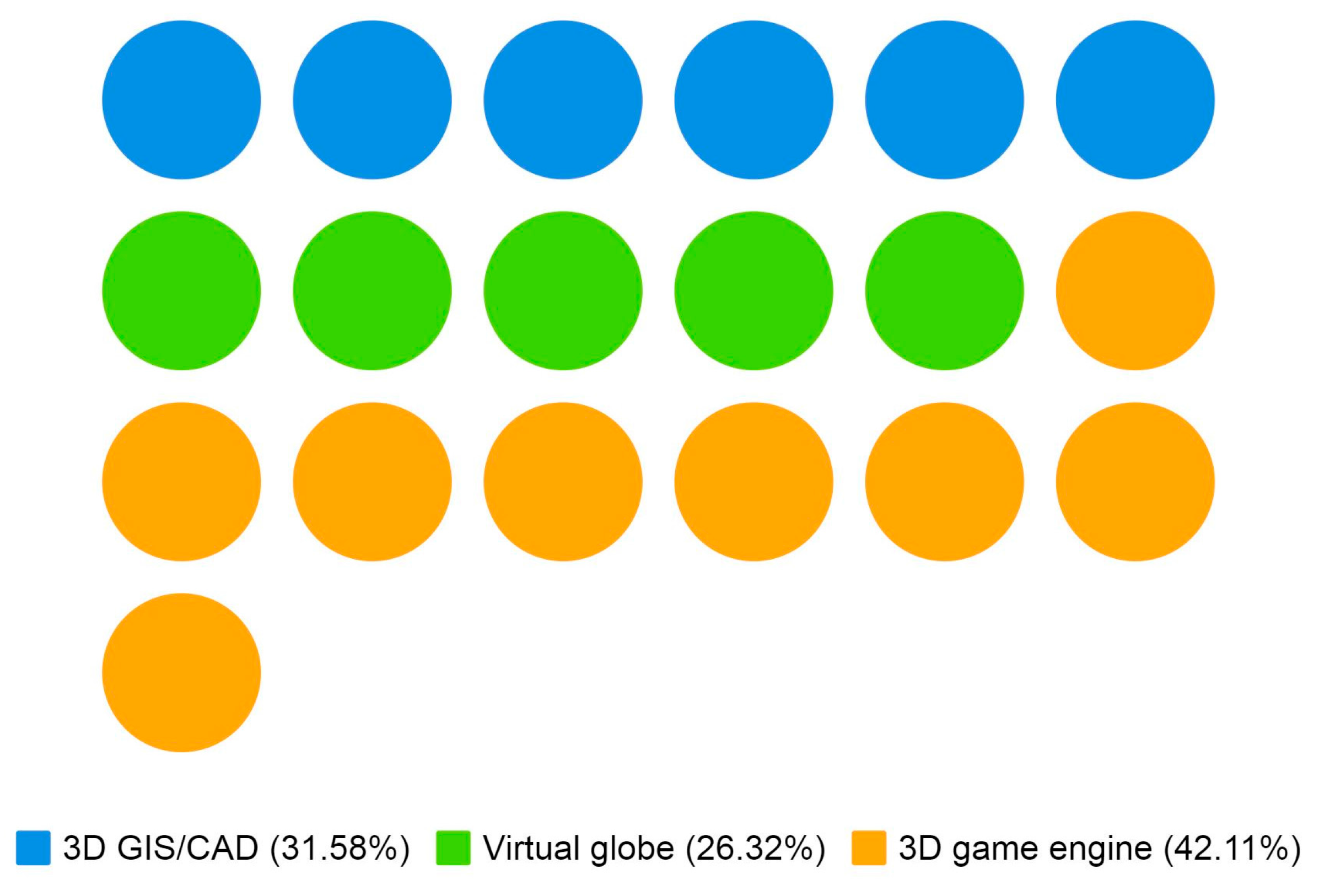
- What is the used platform? As platforms, we considered software solutions that can provide 3D city models for its users and enable a workspace for collaborators, including solutions for maintaining 3D geoinformation (GIS/CAD software), application development platforms (3D game engines), and visualization software (virtual globes).
- Is the 3D city model publicly viewable and/or downloadable as open data?
- What is the regional coverage of the model?
- Does the 3D city model project utilize as-planned information (e.g., BIM)?
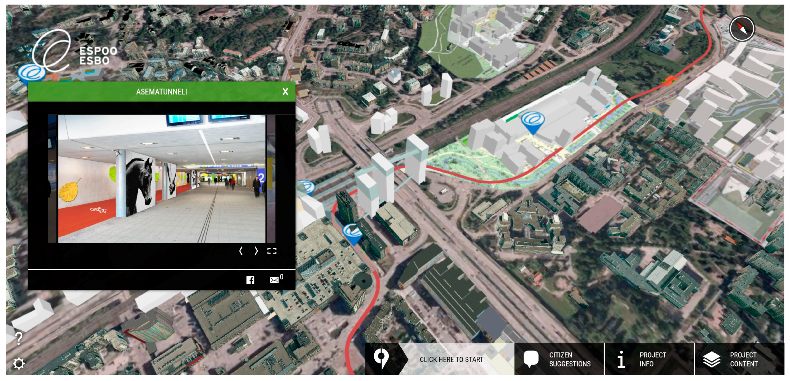
2.1.1. The City of Espoo
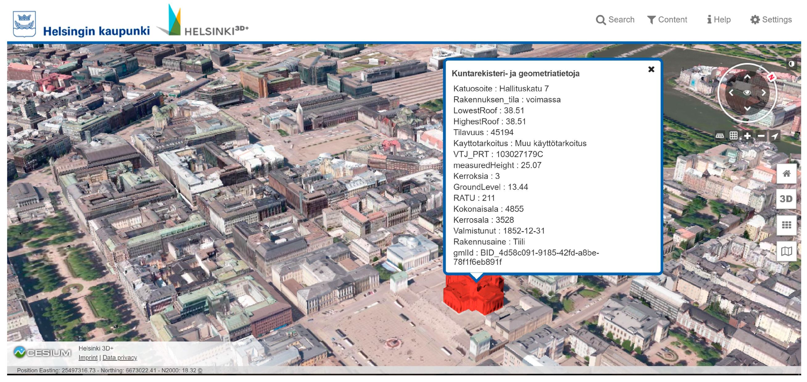
2.1.2. The City of Helsinki
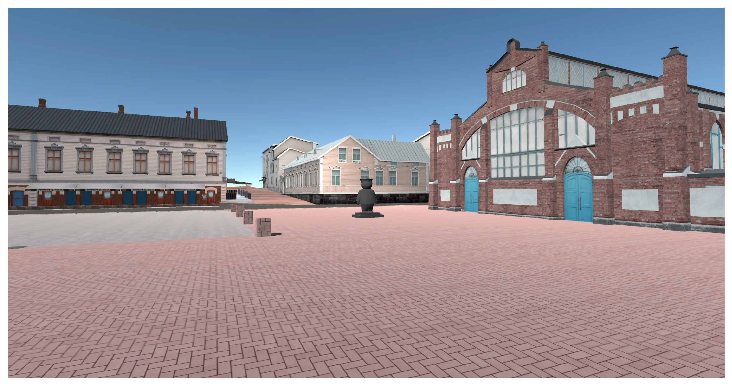
2.1.3. The City of Oulu
2.1.4. The City of Tampere
2.1.5. The City of Turku
2.1.6. The City of Vantaa
2.2. Expert Interviews
- Description of the current situation in the reference city. What is the current situation of 3D city modeling in the city you are representing?
- Expectations regarding 3D city models. Which tasks should the future 3D city models serve?
- Expected users. Who are the expected users of the 3D city model?
- Key factors in the development of 3D city modeling. What can hinder or enhance the development?
- Data. What kind of data is needed to implement a 3D city model?
- Visualization. How should 3D city models be visualized?
3. Results
3.1. Overview Study
3.2. Interviews
4. Discussion
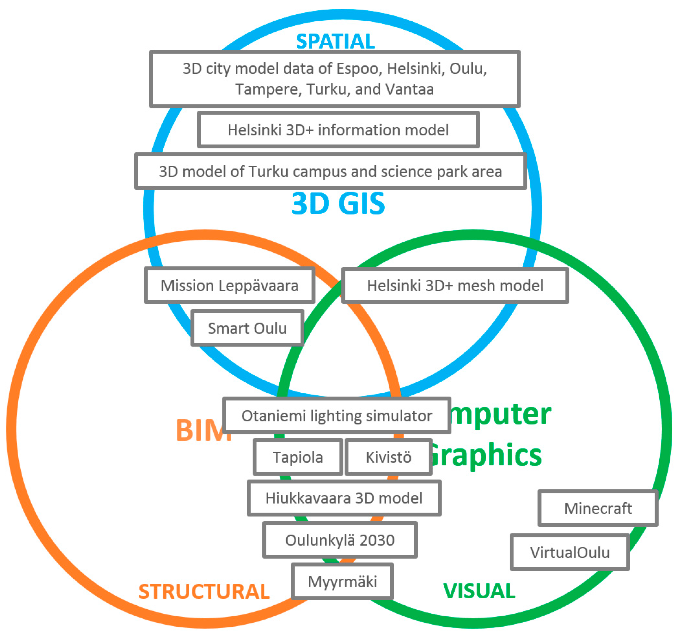
4.1. Characteristics in 3D City Modeling Projects
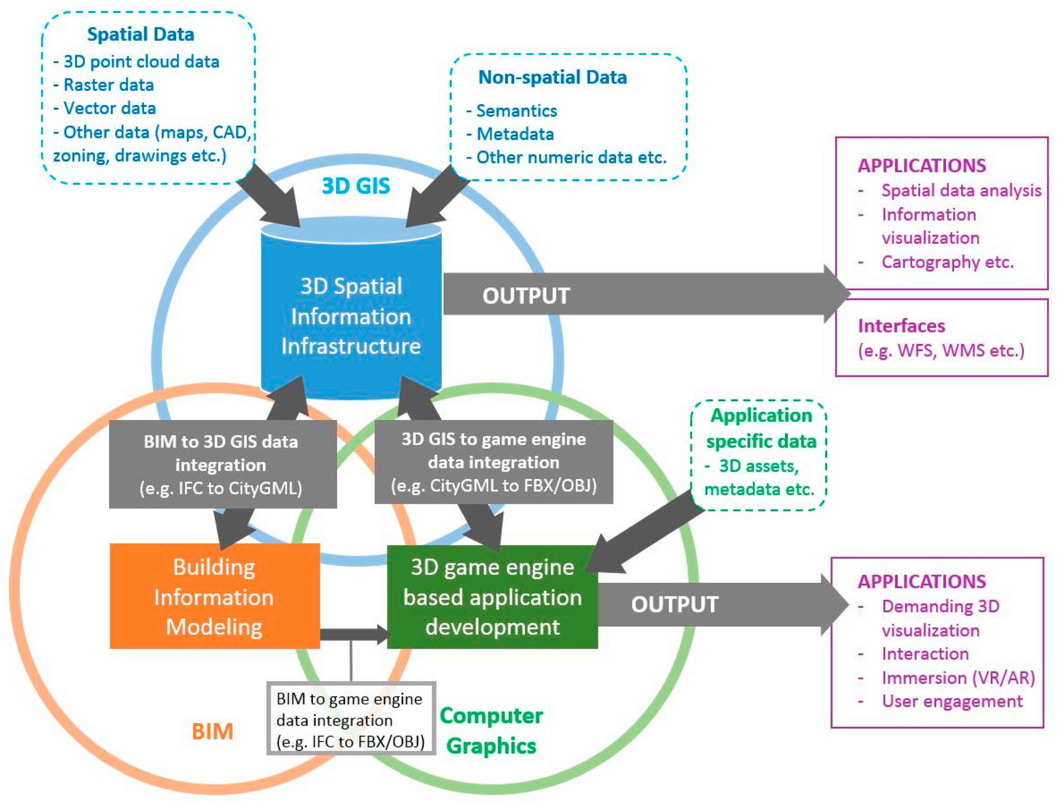
4.2. The Concept for Harmonizing 3D City Modeling
4.3. Limitations and Suggestions for Further Research
5. Conclusions
Acknowledgments
Author Contributions
Conflicts of Interest
References
- Billen, R.; Cutting-Decelle, A.F.; Marina, O.; de Almeida, J.P.; Caglioni, M.; Falquet, G.; Leduc, T.; Métral, C.; Moreau, G.; Perret, J.; et al. 3D City Models and Urban Information: Current Issues and Perspectives; European COST Action TU0801; EDP Sciences: Cedex, France, 2014; pp. 1–118. [Google Scholar]
- Biljecki, F.; Stoter, J.; Ledoux, H.; Zlatanova, S.; Çöltekin, A. Applications of 3D city models: State of the art review. ISPRS Int. Geo-Inf. 2015, 4, 2842–2889. [Google Scholar] [CrossRef]
- Haala, N.; Kada, M. An update on automatic 3D building reconstruction. ISPRS J. Photogramm. Remote Sens. 2010, 65, 570–580. [Google Scholar] [CrossRef]
- Gröger, G.; Plümer, L. CityGML–Interoperable semantic 3D city models. ISPRS J. Photogramm. Remote Sens. 2012, 71, 12–33. [Google Scholar] [CrossRef]
- Rottensteiner, F.; Trinder, J.; Clode, S. Data acquisition for 3D city models from LIDAR extracting buildings and roads. In Proceedings of the 2005 IEEE International Geoscience and Remote Sensing Symposium, Seoul, Korea, 25–29 July 2005. [Google Scholar]
- Rutzinger, M.; Pratihast, A.K.; Oude Elberink, S.J.; Vosselman, G. Tree modelling from mobile laser scanning data-sets. Photogramm. Rec. 2011, 26, 361–372. [Google Scholar] [CrossRef]
- Suveg, I.; Vosselman, G. Reconstruction of 3D building models from aerial images and maps. ISPRS-J. Photogramm. Remote Sens. 2004, 58, 202–224. [Google Scholar] [CrossRef]
- Maas, H.G.; Vosselman, G. Two algorithms for extracting building models from raw laser altimetry data. ISPRS-J. Photogramm. Remote Sens. 1999, 54, 153–163. [Google Scholar] [CrossRef]
- Billen, R.; Cutting-Decelle, A.F.; Métral, C.; Falquet, G.; Zlatanova, S.; Marina, O. Challenges of semantic 3D city models: A contribution of the COST Research Action TU0801. Int. J. 3D Inf. Model. 2015, 4, 68–76. [Google Scholar] [CrossRef]
- Virtanen, J.P.; Hyyppä, H.; Kämäräinen, A.; Hollström, T.; Vastaranta, M.; Hyyppä, J. Intelligent open data 3D maps in a collaborative virtual world. ISPRS Int. Geo-Inf. 2015, 4, 837–857. [Google Scholar] [CrossRef]
- Prandi, F.; Soave, M.; Dev, F.; Andreolli, M.; de Amicis, R. Services oriented smart city platform based on 3D city model visualization. In ISPRS Annals of the Photogrammetry, Remote Sensing and Spatial Information Sciences, Proceedings of ISPRS Technical Commission IV Symposium, Suzhou, China, 14–16 May 2014; Copernicus Publications: Gottingen, Germany, 2014; Volume II, pp. 59–64. [Google Scholar]
- Alatalo, T.; Koskela, T.; Pouke, M.; Alavesa, P.; Ojala, T. VirtualOulu: Collaborative, immersive and extensible 3D city model on the web. In Proceedings of the 21st International Conference on Web3D Technology, Anaheim, CA, USA, 22–24 July 2016; ACM: New York, NY, USA; pp. 95–103. [Google Scholar]
- Clifton, W.E.; Steele, B.; Nelson, G.; Truscott, A.; Itzler, M.; Entwistle, M. Medium altitude airborne Geiger-mode mapping LIDAR system. In Proceedings of the SPIE Defence + Security, Baltimore, MD, USA, 19 May 2015; SPIE: Philadelphia, PA, USA. [Google Scholar]
- Morton, P.J.; Horne, M.; Dalton, R.C.; Thompson, E.M. Virtual city models: Avoidance of obsolescence. In Digital Physicality, Proceedings of the 30th eCAADe Conference, Prague, Czech Republic, 12–14 September 2012; Achten, H., Pavlicek, J., Hulin, J., Matějovska, D., Eds.; Education and Research in Computer Aided Architectural Design in Europe-eCAADe: Brussels, Belgium, 2012; pp. 213–224. [Google Scholar]
- Blaschke, T.; Donert, K.; Gossette, F.; Kienberger, S.; Marani, M.; Qureshi, S.; Tiede, D. Virtual globes: Serving science and society. Information 2012, 3, 372–390. [Google Scholar] [CrossRef]
- Fritsch, D.; Kada, M. Visualisation using game engines. In ISPRS Archives, Proceedings of XXth ISPRS Congress Technical Commission V, Istanbul, Turkey, 12–23 July 2004; Copernicus Gesellschafte. V.: Katlenburg-Lindau, Germany, 2014; Volume 35(B5). [Google Scholar]
- Zlatanova, S. 3D GIS for Urban Development. Ph.D. Thesis, International Institute for Aerospace Survey and Earth Sciences (ITC), Enschede, The Netherlands, 2000; pp. 1–213. Available online: https://3d.bk.tudelft.nl/szlatanova/PhDthesis/pdf/content.html (accessed on 25 November 2017).
- Isikdag, U.; Zlatanova, S. Towards defining a framework for automatic generation of buildings in CityGML using building Information Models. In 3D Geo-Information Sciences; Lee, J., Zlatanova, S., Eds.; Springer: Heidelberg/Berlin, Germany, 2009; pp. 79–96. [Google Scholar]
- Kolbe, T.H. Representing and exchanging 3D city models with CityGML. In 3D Geo-Information Sciences; Lee, J., Zlatanova, S., Eds.; Springer: Heidelberg/Berlin, Germany, 2009; pp. 15–31. [Google Scholar]
- Nagel, C.; Stadler, A.; Kolbe, T.H. Conceptual requirements for the automatic reconstruction of building information models from uninterpreted 3D models. In Proceedings of the Academic Track of Geoweb 2009 Conference, Vancouver, BC, Canada, 27–31 July 2009. [Google Scholar]
- El-Mekawy, M. Integrating BIM and GIS for 3D City Modelling: The Case of IFC and CityGML. Available online: https://pdfs.semanticscholar.org/2315/beacdb74d4f20579b75bc26b4cc19757d648.pdf (accessed on 14 January 2018).
- De Laat, R.; Van Berlo, L. Integration of BIM and GIS: The development of the CityGML GeoBIM extension. In Advances in 3D Geo-Information Sciences; Kolbe, T.H., König, G., Nagel, C., Eds.; Springer: Heidelberg/Berlin, Germany, 2011; pp. 211–225. [Google Scholar]
- Floros, G.; Pispidikis, I.; Dimopoulou, E. Investigating Integration Capabilities between IFC and Citygml LOD3 for 3d City Modelling. Int. Arch. Photogramm. Remote Sens. Spat. Inf. Sci. 2017, XLII-2/W7, 1–6. [Google Scholar] [CrossRef]
- Liu, X.; Wang, X.; Wright, G.; Cheng, J.C.; Li, X.; Liu, R. A State-of-the-Art Review on the Integration of Building Information Modeling (BIM) and Geographic Information System (GIS). ISPRS Int. Geo-Inf. 2017, 6, 53. [Google Scholar] [CrossRef]
- Ohori, K.A.; Biljecki, F.; Diakité, A.; Krijnen, T.; Ledoux, H.; Stoter, J. Towards an integration of GIS and BIM data: What are the geometric and topological issues? In ISPRS Annals of Photogrammetry, Remote Sensing & Spatial Information Sciences, Proceedings of ISPRS 12th Geoinfo Conference, Melbourne, Australia, 26–27 October 2017; Copernicus Publications: Gottingen, Germany, 2017; Volume IV-4/W5, pp. 1–8. [Google Scholar]
- Hagedorn, B.; Döllner, J. High-level web service for 3D building information visualization and analysis. In Proceedings of the 15th Annual ACM International Symposium on Advances in Geographic Information Systems, Seattle, WA, USA, 7–9 November 2007; ACM: New York, NY, USA. [Google Scholar]
- Biljecki, F.; Ledoux, H.; Du, X.; Stoter, J.; Soon, K.H.; Khoo, V.H.S. The most common geometric and semantic errors in CityGML. In ISPRS Annals of Photogrammetry, Remote Sensing & Spatial Information Sciences, Proceedings of ISPRS 11th Geoinfo Conference, Athens, Greece, 20–21 October 2016; Copernicus Publications: Gottingen, Germany, 2016; Volume IV, pp. 13–22. [Google Scholar]
- Tapiola. Available online: http://vrs3d.sito.fi/tapiola/2 (accessed on 20 July 2017).
- Helsinki 3D City Models. Available online: https://www.hel.fi/helsinki/en/administration/information/general/3d/ (accessed on 20 July 2017).
- Liukkonen, O. A Roadmap for Finnish Municipalities—From Basemap to 3D City Model. Master’s Thesis, Aalto University, Helsinki, Finland, 2015; pp. 1–92. Available online: http://urn.fi/URN:NBN:fi:aalto-201505132658 (accessed on 10 October 2017).
- Airaksinen, E. Three-Dimensional City Modelling Methods. Master’s Thesis, Aalto University, Helsinki, Finland, 2017; pp. 1–99. Available online: http://urn.fi/URN:NBN:fi:aalto-201706135482 (accessed on 10 October 2017).
- City Modeling Guidebook. Available online: https://buildingsmart.fi/kaupunki/kaupunkimallinnuksen-ohjekirja/ (accessed on 20 July 2017).
- D City Model Survey. Available online: https://buildingsmart.fi/wp-content/uploads/2016/11/kolmiulotteisetkaupunkimallitkuntienvastaukset.pdf (accessed on 20 October 2017).
- Stoter, J.; Vallet, B.; Lithen, T.; Pla, M.; Wozniak, P.; Kellenberger, T.; Streilein, A.; Ilves, R.; Ledoux, H. State-of-the-art of 3D national mapping in 2016. In International Archives of the Photogrammetry, Remote Sensing and Spatial Information Sciences, Proceedings of XXIII ISPRS Congress, Prague, Czech Republic, 12–19 July 2016; Copernicus Gesellschafte. V.: Katlenburg-Lindau, Germany, 2016; Volume XLI(B4), pp. 653–660. [Google Scholar]
- Geels, F.W. From sectoral systems of innovation to socio-technical systems: Insights about dynamics and change from sociology and institutional theory. Res. Policy 2004, 33, 897–920. [Google Scholar] [CrossRef]
- Bijker, W.E. Of Bicycles, Bakelites, and Bulbs: Toward a Theory of Sociotechnical Change; MIT Press: Cambridge, MA, USA, 1995; pp. 1–390. [Google Scholar]
- Hillier, B. The city as a socio-technical system: A spatial reformulation in the light of the levels problem and the parallel problem. In Digital Urban Modeling and Simulation; Arisona, S.M., Aschwanden, G., Halatsch, J., Wonka, P., Eds.; Springer: Heidelberg/Berlin, Germany, 2012; Volume 242, pp. 24–48. [Google Scholar]
- Anthopoulos, L.G.; Vakali, A. Urban planning and smart cities: Interrelations and reciprocities. In The Future Internet Assembly 2012: From Promises to Reality, Aalborg, Denmark, 10–11 May 2012; Springer: Heidelberg/Berlin, Germany, 2012; pp. 178–189. [Google Scholar]
- Virtanen, J.P.; Kukko, A.; Kaartinen, H.; Jaakkola, A.; Turppa, T.; Hyyppä, H.; Hyyppä, J. Nationwide Point Cloud—The Future Topographic Core Data. ISPRS Int. Geo-Inf. 2017, 6, 243. [Google Scholar] [CrossRef]
- Hanzl, M. Information technology as a tool for public participation in urban planning: A review of experiments and potentials. Des. Stud. 2007, 28, 289–307. [Google Scholar] [CrossRef]
- Palmquist, E.; Shaw, J. Collaborative City Modeling. In Architecture ‘in Computro’, Proceedings of the 26th eCAADe Conference; The Higher Institute of Architectural Sciences: Antwerp, Belgium, 2006; pp. 249–256. [Google Scholar]
- Klimke, J.; Döllner, J. Combining synchronous and asynchronous collaboration within 3D city models. In Proceedings of the 6th International Conference, GIScience, Zurich, Switzerland, 14–17 September 2010; Fabrikant, S.I., Reichenbacher, T., van Kreveld, M., Schlieder, S., Eds.; Springer: Heidelberg/Berlin, Germany, 2010; pp. 115–129. [Google Scholar]
- Trimble Locus. Available online: https://kunnat.trimble.fi/trimble-locus.html (accessed on 13 September 2017).
- City Modeling in Espoo. 2016. Available online: http://docplayer.fi/19353085-Kaupunkimallintaminen-espoossa-2016-tapani-honkanen.html (accessed on 14 September 2017).
- D Buildings of Espoo. Available online: http://www.hri.fi/fi/dataset/espoon-3d-rakennukset (accessed on 13 September 2017).
- CityPlanner. Available online: https://cityplanneronline.com/site/ (accessed on 15 November 2017).
- Tehtävä Leppävaarassa. Available online: http://cityplanneronline.com/Espoonkaupunki/TehtavaLeppavaarassa (accessed on 13 September 2017).
- Unity Game Engine. Available online: https://unity3d.com/ (accessed on 15 November 2017).
- Otaniemi Lighting Simulation. Available online: http://vrs3d.sito.fi/Otaniemen%20alueen%20valaistussimulointi/10 (accessed on 20 July 2017).
- Gröger, G.; Kolbe, T.H.; Nagel, C.; Häfele, K.H. OGC City Geography Markup Language (CityGML) Encoding Standard; Version 2.0, OGC doc no. 12-019; Open Geospatial Consortium: Wayland, MA, USA, 2012. [Google Scholar]
- D City Models of Helsinki. Available online: http://www.hri.fi/fi/dataset/helsingin-3d-kaupunkimalli (accessed on 13 September 2017).
- Cesium—WebGL Virtual Globe. Available online: https://cesiumjs.org/ (accessed on 20 October 2017).
- Helsinki 3D+ Information Model. Available online: https://kartta.hel.fi/3d/ (accessed on 20 July 2017).
- Bentley ContextCapture. Available online: https://www.bentley.com/en/products/brands/contextcapture (accessed on 14 September 2017).
- Helsinki 3D+ Mesh Model. Available online: https://kartta.hel.fi/3d/mesh/ (accessed on 20 July 2017).
- Utilization of New Generation City Information Models. Available online: https://www.hel.fi/helsinki/fi/kaupunki-ja-hallinto/tietoa-helsingista/yleistietoa-helsingista/Helsinki-3d/mallin-hyodyntaminen/ (accessed on 15 November 2017).
- Bentley Microstation. Available online: https://www.bentley.com/en/products/brands/microstation (accessed on 14 September 2017).
- D Buildings of Helsinki. Available online: http://www.hri.fi/fi/dataset/helsingin-3d-rakennukset (accessed on 13 September 2017).
- Helsinki Online Map Service. Available online: http://kartta.hel.fi/ (accessed on 20 July 2017).
- Lidar Datasets of the City of Helsinki. Available online: http://www.hri.fi/en/dataset/helsingin-laserkeilausaineistot (accessed on 13 September 2017).
- Oulunkylä. 2030. Available online: https://mallikaupunki.fi/oulunkyla/ (accessed on 17 September 2017).
- Virtual Oulu. Available online: http://ubicomp.oulu.fi/infrastructure-virtualoulu/ (accessed on 3 December 2017).
- Virtual City Model from Oulu. Available online: https://www.databusiness.fi/fi/blogi/virtuaalikaupunkimalli-oulusta/ (accessed 17 September 2017).
- Hiukkavaara District of Oulu. Available online: http://hiukkavaara3d.ouka.fi/ (accessed 18 September 2017).
- MAPGETS. Available online: https://mapgets.com/ (accessed on 17 September 2017).
- SmartOulu. Available online: http://smartoulu.mapgets.com (accessed on 17 September 2017).
- Trimble Novapoint & Quadri. Available online: http://www.novapoint.com/ (accessed on 15 October 2017).
- AutoCAD. Available online: https://www.autodesk.com/products/autocad/overview (accessed on 20 October 2017).
- Tampere City Model Index. Available online: http://kartat.tampere.fi/splashscreen/ (accessed on 13 September 2017).
- Open City Model of Tampere. Available online: https://www.hsy.fi/fi/asiantuntijalle/tapahtumat/seminaarit/paikkatietoseminaarit/Documents/2016/coloma_hsy_paikkatietoseminaari_2016.pdf (accessed on 21 July 2017).
- D Models of Turku. Available online: https://www.turku.fi/turku-tieto/kartat-ja-paikkatieto/tilaa-karttoja/3d-mallit (accessed on 13 September 2017).
- D Model of Turku Campus and Science Park Area. Available online: http://www.lounaistieto.fi/blog/2017/09/06/turun-kampus-ja-tiedepuistoalueen-3d-kaupunkimalli/ (accessed on 18 October 2017).
- Browser-Based 3D Model of Turku Campus and Science Park Area. Available online: https://turkuhackathon.appspot.com/ (accessed on 18 October 2017).
- D Buildings of Vantaa. Available online: http://www.hri.fi/fi/dataset/vantaan-3d-rakennukset (accessed on 13 September 2017).
- Vantaa Housing Fair. Available online: http://vrs3d.sito.fi/Vantaan%20asuntomessut/16 (accessed on 17 September 2017).
- Build Vantaa in Minecraft. Available online: http://www.vantaa.fi/asuminen_ja_ymparisto/rakentaminen/maanmittauspalvelut/kartat/minecraft (accessed on 13 September 2017).
- Myyrmäki. Available online: https://www.mallikaupunki.fi/myyrmaki/ (accessed on 18 October 2017).
- Vantaa as a Digital Forerunner in City Planning and Construction. Available online: http://www.esri.fi/News/2016/vantaalle-digitaalinen-kokonaisratkaisu (accessed on 21 July2017).
- Döllner, J.; Baumann, K.; Buchholz, H. Virtual 3D city models as foundation of complex urban information spaces. In Proceedings of the 11th International Conference on Urban Planning and Spatial Development in the Information Society, Vienna, Austria, 13–16 February 2006. [Google Scholar]
- Ylipulli, J.; Kangasvuo, J.; Alatalo, T.; Ojala, T. Chasing Digital Shadows: Exploring future hybrid cities through anthropological design fiction. In Proceedings of the NordiCHI’16: Nordic Conference on Human-Computer Interaction, Gothenburg, Sweden, 23–27 October 2016; ACM Press: New York, NY, USA, 2016. [Google Scholar]
- Buyuksalih, I.; Bayburt, S.; Buyuksalih, G.; Baskaraca, A.P.; Karim, H.; Rahman, A.A. 3D modelling and visualization based on the Unity game engine—Advantages and challenges. In ISPRS Annals of Photogrammetry, Remote Sensing & Spatial Information Sciences, Proceedings of ISPRS 4th International GeoAdvances Workshop, Safranbolu, Karabuk, Turkey, 14–15 October 2017; Copernicus Publications: Gottingen, Germany, 2017; Volume IV-4/W4, pp. 161–166. [Google Scholar]
- Indraprastha, A.; Shinozaki, M. The investigation on using Unity3D game engine in urban design study. J. ICT Res. Appl. 2009, 3, 1–18. [Google Scholar] [CrossRef]
- Ruzinoor C., M.; Shariff, A.R.M.; Zulkifli, A.N.; Rahim, M.S.M.; Mahayudin, M.H. Using game engine for 3D terrain visualisation of GIS data: A review. In Proceedings of the 7th IGRSM International Remote Sensing & GIS Conference and Exhibition, Kuala Lumpur, Malaysia, 22–23 April 2014. [Google Scholar]


| City | Project |
|---|---|
| Espoo | 3D city model data |
| Mission Leppävaara | |
| Otaniemi lighting simulation | |
| Tapiola | |
| Helsinki | Helsinki 3D+ information model |
| Helsinki 3D+ mesh model | |
| 3D city model data | |
| Oulunkylä 2030 | |
| Oulu | 3D city model data |
| VirtualOulu | |
| Hiukkavaara 3D model | |
| SmartOulu | |
| Tampere | 3D city model data |
| Turku | 3D city model data |
| 3D model of Turku campus and science park area | |
| Vantaa | 3D city model data |
| Kivistö | |
| Minecraft | |
| Myyrmäki |
| Reference City | Number of Informants Representing the City Organization | Number of Informants not Representing the City Organization | Number of Interviewers | Total Number of Participants |
|---|---|---|---|---|
| Espoo | 6 | 2 | 8 | |
| Helsinki | 1 | 3 | 4 | |
| Oulu | 5 | 1 | 2 | 8 |
| Tampere | 4 | 4 | 8 | |
| Turku | 9 | 3 | 12 | |
| Vantaa | 4 | 4 | 3 | 11 |
| City | Project | Used Platform(s) | Data Accessibility | Full City Data Coverage | Utilization of As-Planned Information | |
|---|---|---|---|---|---|---|
| Data Publicly Viewable | Data Publicly Downloadable | |||||
| Espoo | 3D city model data | Locus | - | X | X | - |
| Mission Leppävaara | CityPlanner | X | - | - | X | |
| Otaniemi lighting simulation | Unity | X | - | - | X | |
| Tapiola | Unity | X | - | - | X | |
| Helsinki | Helsinki 3D+ information model | Cesium | X | X | X | - |
| Helsinki 3D+ mesh model | Cesium | X | X | X | - | |
| 3D city model data | Microstation | - | X | X | - | |
| Oulunkylä 2030 | Unity | X | - | - | X | |
| Oulu | 3D city model data | Locus | - | X | X | - |
| VirtualOulu | Unity, Unreal Engine | X | X | - | - | |
| Hiukkavaara 3D model | Unity | X | - | - | X | |
| SmartOulu | MAPGETS | X | - | X | X | |
| Tampere | 3D city model data | Novapoint, Quadri, AutoCAD, Viasys VDC | X | X | X | - |
| Turku | 3D city model data | Locus | - | - | X | - |
| 3D model of Turku campus and science park area | Sova3D | X | X | - | - | |
| Vantaa | 3D city model data | Microstation | - | X | X | - |
| Kivistö | Unity | X | - | - | X | |
| Minecraft | Minecraft | - | X | X | - | |
| Myyrmäki | Unity | X | - | - | X | |
| Total | 19 | 13 | 13 | 10 | 10 | 8 |
| 3D GIS | BIM | Computer Graphics |
|---|---|---|
| Focus in real world data [18,22] | Focus in as-planned data [18,24] | Real world and as-planned data |
| Simplified model complexity (geometry and semantics) [12,18,21] | High model complexity (geometry and semantics) [21] | Intermediate model complexity (geometry) [12] |
| Citywide data coverage | Local data coverage | Local data coverage |
| Global coordinate systems [21,25] | Limited use of coordinate systems [18,24,25] | Limited use of coordinate systems [81] |
| Database approach (maintained models) [22] | Life-cycle approach [18,24] | Felixible application development approach [12,16,81,82,83] |
| Automated or semi-automated modeling (geometry) [3] | Manual modeling [21] | Manual modeling [12,81,82] |
| User engagement (immersion, interactivity and multi-user environments) [12,82] | ||
| Visual realism (real-time rendering) [12] |
© 2018 by the authors. Licensee MDPI, Basel, Switzerland. This article is an open access article distributed under the terms and conditions of the Creative Commons Attribution (CC BY) license (http://creativecommons.org/licenses/by/4.0/).
Share and Cite
Julin, A.; Jaalama, K.; Virtanen, J.-P.; Pouke, M.; Ylipulli, J.; Vaaja, M.; Hyyppä, J.; Hyyppä, H. Characterizing 3D City Modeling Projects: Towards a Harmonized Interoperable System. ISPRS Int. J. Geo-Inf. 2018, 7, 55. https://doi.org/10.3390/ijgi7020055
Julin A, Jaalama K, Virtanen J-P, Pouke M, Ylipulli J, Vaaja M, Hyyppä J, Hyyppä H. Characterizing 3D City Modeling Projects: Towards a Harmonized Interoperable System. ISPRS International Journal of Geo-Information. 2018; 7(2):55. https://doi.org/10.3390/ijgi7020055
Chicago/Turabian StyleJulin, Arttu, Kaisa Jaalama, Juho-Pekka Virtanen, Matti Pouke, Johanna Ylipulli, Matti Vaaja, Juha Hyyppä, and Hannu Hyyppä. 2018. "Characterizing 3D City Modeling Projects: Towards a Harmonized Interoperable System" ISPRS International Journal of Geo-Information 7, no. 2: 55. https://doi.org/10.3390/ijgi7020055
APA StyleJulin, A., Jaalama, K., Virtanen, J.-P., Pouke, M., Ylipulli, J., Vaaja, M., Hyyppä, J., & Hyyppä, H. (2018). Characterizing 3D City Modeling Projects: Towards a Harmonized Interoperable System. ISPRS International Journal of Geo-Information, 7(2), 55. https://doi.org/10.3390/ijgi7020055