From a Vegetation Index to a Sustainable Development Goal Indicator: Forest Trend Monitoring Using Three Decades of Earth Observations across Switzerland

 , and
, and 
Abstract
1. Introduction
2. Materials and Methods
2.1. The SDG Indicator
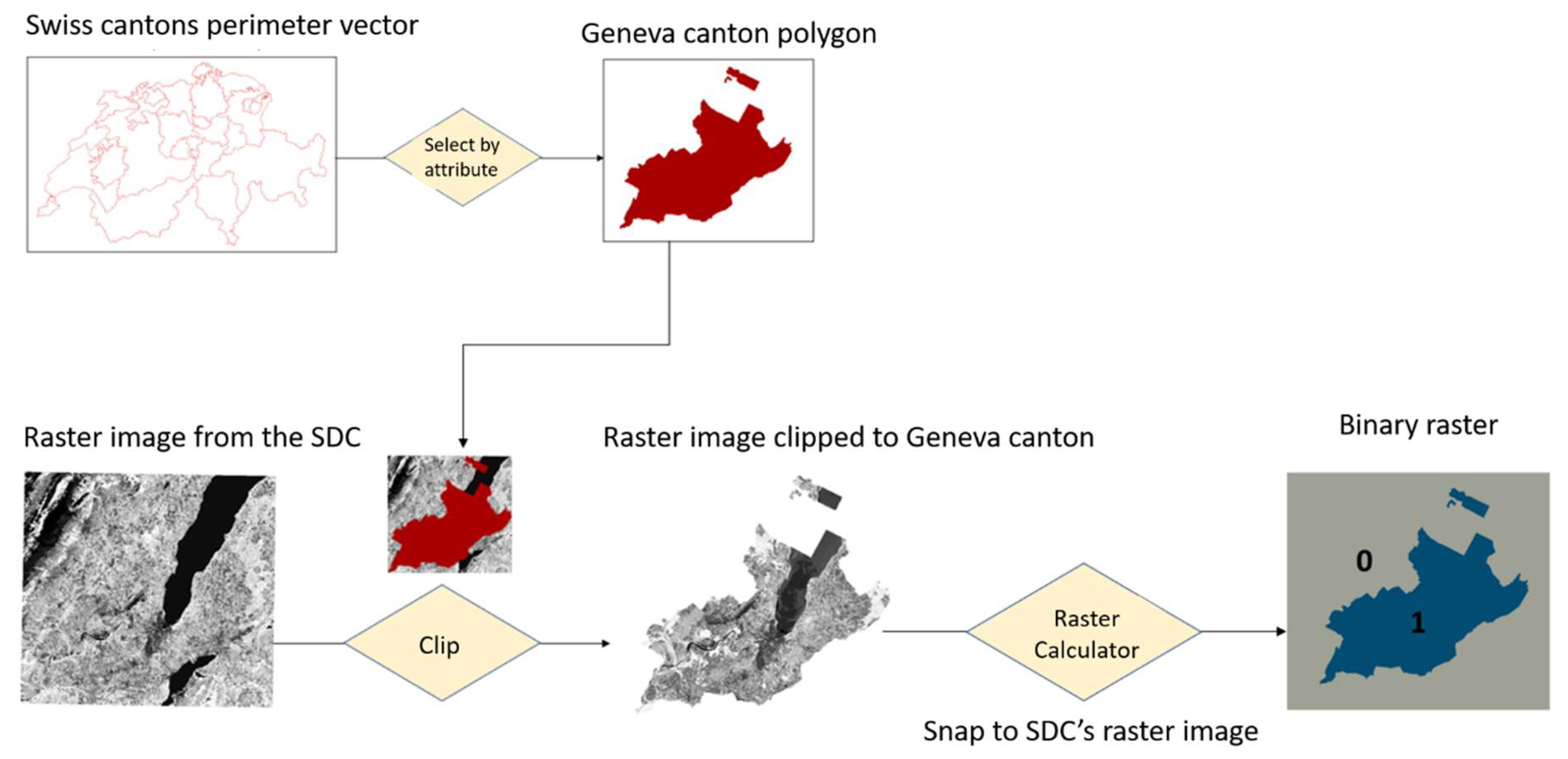
2.2. Algorithm Implementation
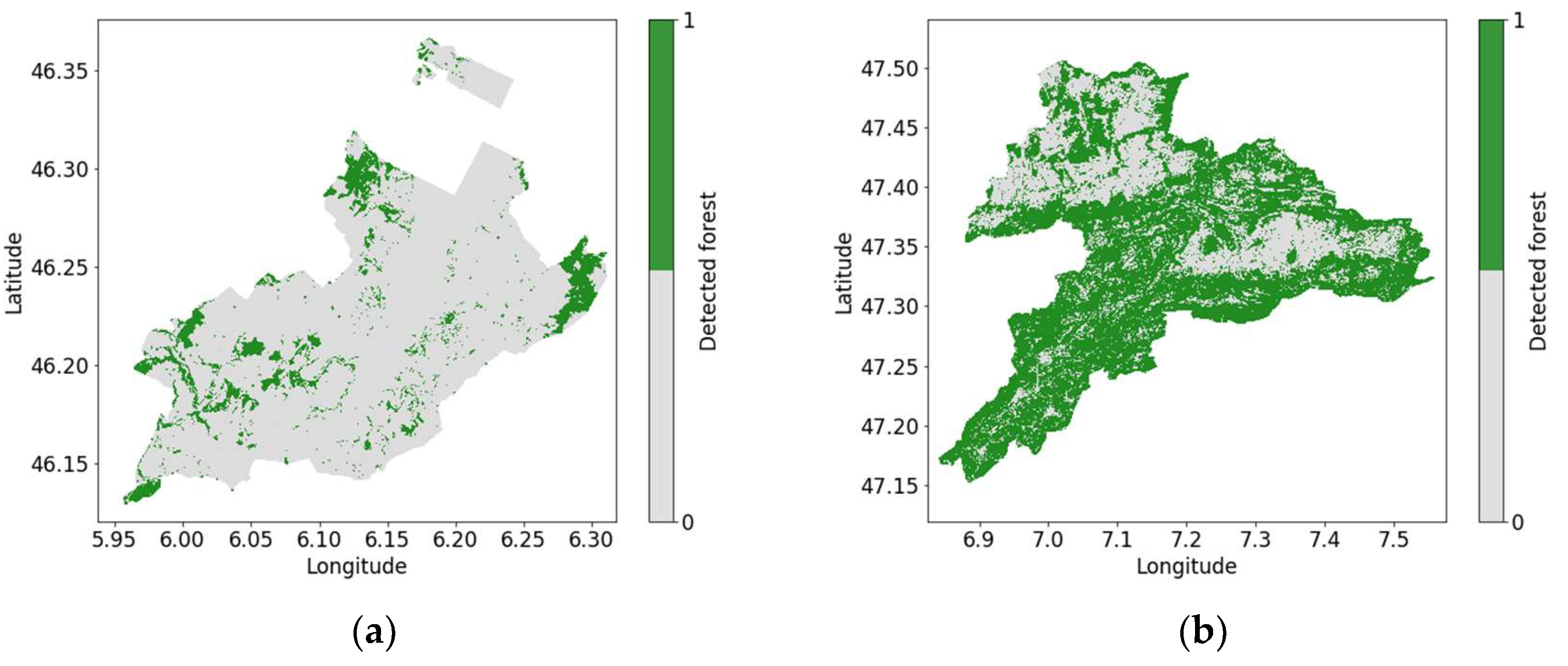
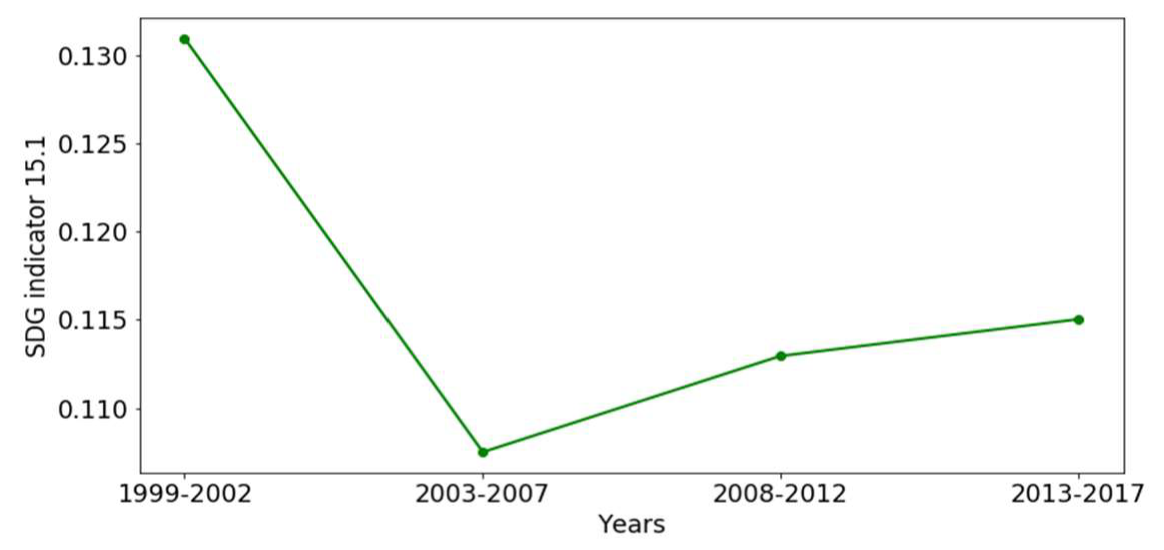
3. Results
4. Discussion
5. Conclusions
Author Contributions
Funding
Acknowledgments
Conflicts of Interest
References
- United Nations Statistics Division (UNSD). Sustainable Development Goals Report; UNSD: Washington, DC, USA, 2016. [Google Scholar]
- United Nations. SDG Indicators. 2018. Available online: https://unstats.un.org (accessed on 13 June 2018).
- UNECE. Joint UNECE/Eurostat/OECD Working Group on Statistics on Sustainable Development. Available online: https://www.unece.org/stats/groups/wgssd.tor.html (accessed on 10 October 2018).
- Guo, H.; Liu, Z.; Jiang, H.; Wang, C.; Liu, J.; Liang, D. Big Earth Data: A new challenge and opportunity for Digital Earth’s development. Int. J. Digit. Earth 2017, 10, 1–12. [Google Scholar] [CrossRef]
- Boulton, G. The challenges of a Big Data Earth. Big Earth Data 2018, 2, 1–7. [Google Scholar] [CrossRef]
- Giuliani, G.; Dao, H.; De Bono, A.; Chatenoux, B.; Allenbach, K.; De Laborie, P.; Rodila, D.; Alexandris, N.; Peduzzi, P. Live monitoring of earth surface (LiMES): A framework for monitoring environmental changes from earth observations. Remote Sens. Environ. 2017, 202, 222–233. [Google Scholar] [CrossRef]
- Anderson, K.; Ryan, B.; Sonntag, W.; Kavvada, A.; Friedl, L. Earth observation in service of the 2030 Agenda for Sustainable Development. Geo-Spat. Inf. Sci. 2017, 20, 77–96. [Google Scholar] [CrossRef]
- Lewis, A.; Lymburner, L.; Purss, M.B.; Brooke, B.; Evans, B.; Ip, A.; Dekker, A.G.; Irons, J.R.; Minchin, S.; Mueller, N.; et al. Rapid, high-resolution detection of environmental change over continental scales from satellite data—The Earth Observation Data Cube. Int. J. Digit. Earth 2016, 9, 106–111. [Google Scholar] [CrossRef]
- Purss, M.B.; Lewis, A.; Oliver, S.; Ip, A.; Sixsmith, J.; Evans, B.; Edberg, R.; Frankish, G.; Hurst, L.; Chan, T. Unlocking the Australian Landsat Archive—From dark data to High Performance Data infrastructures. GeoResJ 2015, 6 (Suppl. C), 135–140. [Google Scholar] [CrossRef]
- Woodcock, C.E.; Allen, R.; Anderson, M.; Belward, A.; Bindschadler, R.; Cohen, W.; Gao, F.; Goward, S.N.; Helder, D.; Helmer, E.; et al. Free Access to Landsat Imagery. Science 2008, 320, 1011. [Google Scholar] [CrossRef] [PubMed]
- Giuliani, G.; Chatenoux, B.; De Bono, A.; Rodila, D.; Richard, J.P.; Allenbach, K.; Dao, H.; Peduzzi, P. Building an Earth Observations Data Cube: lessons learned from the Swiss Data Cube (SDC) on generating Analysis Ready Data (ARD). Big Earth Data 2017, 1, 100–117. [Google Scholar] [CrossRef]
- Group on Earth Observations (GEO). Earth Observations in Support of the 2030 Agenda for Sustainable Development; Japan Aerospace Exploration Agency (JAXA) on Behalf of GEO under the EO4SDG Initiative: Tokyo, Japan, 2017. [Google Scholar]
- Ouyang, Z.; Zheng, H.; Xiao, Y.; Polasky, S.; Liu, J.; Xu, W.; Wang, Q.; Zhang, L.; Xiao, Y.; Rao, E.; et al. Improvements in ecosystem services from investments in natural capital. Science 2016, 352, 1455–1459. [Google Scholar] [CrossRef] [PubMed]
- World Resources Institute. Forests and SDGs: Taking a Second Look|World Resources Institute. Available online: https://www.wri.org/blog/2017/09/forests-and-sdgs-taking-second-look (accessed on 9 October 2018).
- Yengoh, G.T.; Dent, D.; Olsson, L.; Tengberg, A.E.; Tucker, C.J. The Use of the Normalized Difference Vegetation Index (NDVI) to Assess Land Degradation at Multiple Scales: A Review of the Current Status, Future Trends, and Practical Considerations; Lund University Center for Sustainability Studies (LUCSUS) and the Scientific and Technical Advisory Panel of the Global Environment Facility (STAP/GEF): Lund, Sweden, 2014. [Google Scholar]
- Rouse, J.W., Jr. Monitoring the Vernal Advancement and Retrogradation (Green Wave Effect) of Natural Vegetation; NASA: College Station, TX, USA, 1972.
- Rouse, J., Jr.; Haas, R.H.; Schell, J.A.; Deering, D.W. Monitoring Vegetation Systems in the Great Plains with ERTS; NASA: College Station, TX, USA, 1974.
- RColditz, R.; Ressl, R.A.; Bonilla-Moheno, M. Trends in 15-year MODIS NDVI time series for Mexico. In Proceedings of the 8th International Workshop on the Analysis of Multitemporal Remote Sensing Images (Multi-Temp), Annecy, France, 22–24 July 2015; pp. 1–4. [Google Scholar]
- Ceroni, M.; Achkar, M.; Gazzano, I.; Burgueño, J. Study of the NDVI with multi-scale and time-series analysis using SPOT imagery during the period 1998–2012 in Uruguay. Rev. Teledetec. 2015, 31–42. [Google Scholar] [CrossRef]
- Picoli, M.C.; Camara, G.; Sanches, I.; Simões, R.; Carvalho, A.; Maciel, A.; Coutinho, A.; Esquerdo, J.; Antunes, J.; Begotti, R.A.; et al. Big earth observation time series analysis for monitoring Brazilian agriculture. ISPRS J. Photogramm. Remote Sens. 2018, 145, 328–339. [Google Scholar] [CrossRef]
- Eckert, S.; Hüsler, F.; Liniger, H.; Hodel, E. Trend analysis of MODIS NDVI time series for detecting land degradation and regeneration in Mongolia. J. Arid Environ. 2015, 113, 16–28. [Google Scholar] [CrossRef]
- Schubarth, C.; IC Infraconsult AG; Weibel, F.; OFS. L’utilisation du sol en Suisse–Résultats de la statistique de la superficie; Office fédéral de la statistique (OFS): Neuchâtel, Switzerland, 2013. [Google Scholar]
- IFN. L’inventaire forestier national suisse (IFN). 2018. Available online: https://www.lfi.ch/lfi/lfi-fr.php (accessed on 18 February 2018).
- FAO of the UN. FRA 2000 on Definitions of Forest and Forest Change. 2018. Available online: http://www.fao.org/docrep/006/ad665e/ad665e00.htm#TopOfPage (accessed on 15 June 2018).
- VanderPlas, J. Python Data Science Handbook: Essential Tools for Working with Data; O’Reilly Media, Inc.: Newton, MA, USA, 2016. [Google Scholar]
- Office Fédéral de l’Environnement OFEV, “Division Forêts. 2018. Available online: https://www.bafu.admin.ch/bafu/fr/home/office/divisions-sections/division-forets.html (accessed on 18 April 2018).
- Canton de Genève. Forêt|Nature. 2018. Available online: http://ge.ch/nature/foret (accessed on 18 April 2018).
- République et Canton du Jura. Forêts jurassiennes—République et Canton du Jura. Available online: https://www.jura.ch/DEN/ENV/Forets/Forets-jurassiennes.html (accessed on 22 August 2018).
- Congalton, R.G. Accuracy assessment and validation of remotely sensed and other spatial information. Int. J. Wildland Fire 2001, 10, 321–328. [Google Scholar] [CrossRef]
- SITG. Cartes professionnelles|SITG. 2018. Available online: https://ge.ch/sitg/cartes/professionnelles (accessed on 18 April 2018).
- Desai, D.; Schomerus, M. ‘There Was A Third Man…’: Tales from a Global Policy Consultation on Indicators for the Sustainable Development Goals-Desai-2018-Development and Change. Dev. Chang. 2017, 49, 89–115. [Google Scholar] [CrossRef]
- Kaika, M. ‘Don’t call me resilient again!’: The New Urban Agenda as immunology … or … what happens when communities refuse to be vaccinated with ‘smart cities’ and indicators. Environ. Urban. 2017, 29, 89–102. [Google Scholar] [CrossRef]
- Robinson, N.P.; Allred, B.W.; Jones, M.O.; Moreno, A.; Kimball, J.S.; Naugle, D.E.; Erickson, T.A.; Richardson, A.D. A Dynamic Landsat Derived Normalized Difference Vegetation Index (NDVI) Product for the Conterminous United States. Remote Sens. 2017, 9, 863. [Google Scholar] [CrossRef]
- Redowan, M.; Kanan, A.H. Potentials and Limitations of NDVI and other Vegetation Indices (VIS) for Monitoring Vegetation Parameters from Remotely Sensed Data. Bangladesh Res. Pub. J. 2012, 7, 291–299. [Google Scholar]
- Baniya, B.; Tang, Q.; Huang, Z.; Sun, S.; Techato, K.A. Spatial and Temporal Variation of NDVI in Response to Climate Change and the Implication for Carbon Dynamics in Nepal. Forests 2018, 9, 329. [Google Scholar] [CrossRef]
- Schmidt, S.; Alewell, C.; Meusburger, K. Mapping spatio-temporal dynamics of the cover and management factor (C-factor) for grasslands in Switzerland. Remote Sens. Environ. 2018, 211, 89–104. [Google Scholar] [CrossRef]
- Poursanidis, D.; Chrysoulakis, N.; Mitraka, Z. Landsat 8 vs. Landsat 5: A comparison based on urban and peri-urban land cover mapping. Int. J. Appl. Earth Obs. Geoinf. 2015, 35, 259–269. [Google Scholar] [CrossRef]
- Forkel, M.; Carvalhais, N.; Verbesselt, J.; Mahecha, M.D.; Neigh, C.; Reichstein, M. Trend change detection in NDVI time series: Effects of inter-annual variability and methodology. Remote Sens. 2013, 5, 2113–2144. [Google Scholar] [CrossRef]
- González-Alonso, F.; Merino-De-Miguel, S.; Roldán-Zamarrón, A.; García-Gigorro, S.; Cuevas, J.M. Forest biomass estimation through NDVI composites. The role of remotely sensed data to assess Spanish forests as carbon sinks. Int. J. Remote Sens. 2006, 27, 5409–5415. [Google Scholar] [CrossRef]
- Jiang, Z.; Huete, A.R.; Chen, J.; Chen, Y.; Li, J.; Yan, G.; Zhang, X. Analysis of NDVI and scaled difference vegetation index retrievals of vegetation fraction. Remote Sens. Environ. 2006, 101, 366–378. [Google Scholar] [CrossRef]
- Zhang, H.K.; Roy, D.P.; Yan, L.; Li, Z.; Huang, H.; Vermote, E.; Skakun, S.; Roger, J.C. Characterization of Sentinel-2A and Landsat-8 top of atmosphere, surface, and nadir BRDF adjusted reflectance and NDVI differences. Remote Sens. Environ. 2018, 215, 482–494. [Google Scholar] [CrossRef]
- European Space Agency. Satellite Earth Observations in Support of the Sustainable Development Goals—Special 2018 Edition; European Space Agency: Paris, France, 2018. [Google Scholar]


| Reference | ||||
|---|---|---|---|---|
| Non-Forest | Forest | Total | ||
| Classified | Non-Forest | 370416 | 25465 | 395881 |
| Forest | 7831 | 43622 | 51453 | |
| Total | 378247 | 69087 | 447334 | |
| Overall accuracy 414038/447334 = 93% | ||||
| Producer’s Accuracy | User’s Accuracy | |||
| Non-Forest | 370416/378247 = 98% | Non-Forest | 370416/395881 = 94% | |
| Forest | 43622/69087 = 63% | Forest | 43622/51453 = 85% | |
| Forest Surface (km2) | Forest Pixels (nr.) | Forest Percentage (%) | |
|---|---|---|---|
| 1999–2002 | 36.61 | 58572 | 13.09 |
| 2003–2007 | 30.05 | 48088 | 10.75 |
| 2008–2012 | 31.58 | 50522 | 11.29 |
| 2013–2017 | 32.16 | 51453 | 11.50 |
| Relative Variation (%) | 1999–2002 | 2003–2007 | 2008–2012 | 2013–2017 |
|---|---|---|---|---|
| 1999–2002 | −17.92 | −13.74 | −12.16 | |
| 2003–2007 | 5.09 | 7.02 | ||
| 2008–2012 | 1.84 |
© 2018 by the authors. Licensee MDPI, Basel, Switzerland. This article is an open access article distributed under the terms and conditions of the Creative Commons Attribution (CC BY) license (http://creativecommons.org/licenses/by/4.0/).
Share and Cite
Honeck, E.; Castello, R.; Chatenoux, B.; Richard, J.-P.; Lehmann, A.; Giuliani, G. From a Vegetation Index to a Sustainable Development Goal Indicator: Forest Trend Monitoring Using Three Decades of Earth Observations across Switzerland. ISPRS Int. J. Geo-Inf. 2018, 7, 455. https://doi.org/10.3390/ijgi7120455
Honeck E, Castello R, Chatenoux B, Richard J-P, Lehmann A, Giuliani G. From a Vegetation Index to a Sustainable Development Goal Indicator: Forest Trend Monitoring Using Three Decades of Earth Observations across Switzerland. ISPRS International Journal of Geo-Information. 2018; 7(12):455. https://doi.org/10.3390/ijgi7120455
Chicago/Turabian StyleHoneck, Erica, Roberto Castello, Bruno Chatenoux, Jean-Philippe Richard, Anthony Lehmann, and Gregory Giuliani. 2018. "From a Vegetation Index to a Sustainable Development Goal Indicator: Forest Trend Monitoring Using Three Decades of Earth Observations across Switzerland" ISPRS International Journal of Geo-Information 7, no. 12: 455. https://doi.org/10.3390/ijgi7120455
APA StyleHoneck, E., Castello, R., Chatenoux, B., Richard, J.-P., Lehmann, A., & Giuliani, G. (2018). From a Vegetation Index to a Sustainable Development Goal Indicator: Forest Trend Monitoring Using Three Decades of Earth Observations across Switzerland. ISPRS International Journal of Geo-Information, 7(12), 455. https://doi.org/10.3390/ijgi7120455