
Exploring the Relationship between the Arid Valley Boundary’s Displacement and Climate Change during 1999–2013 in the Upper Reaches of the Min River, China


Abstract
:1. Introduction
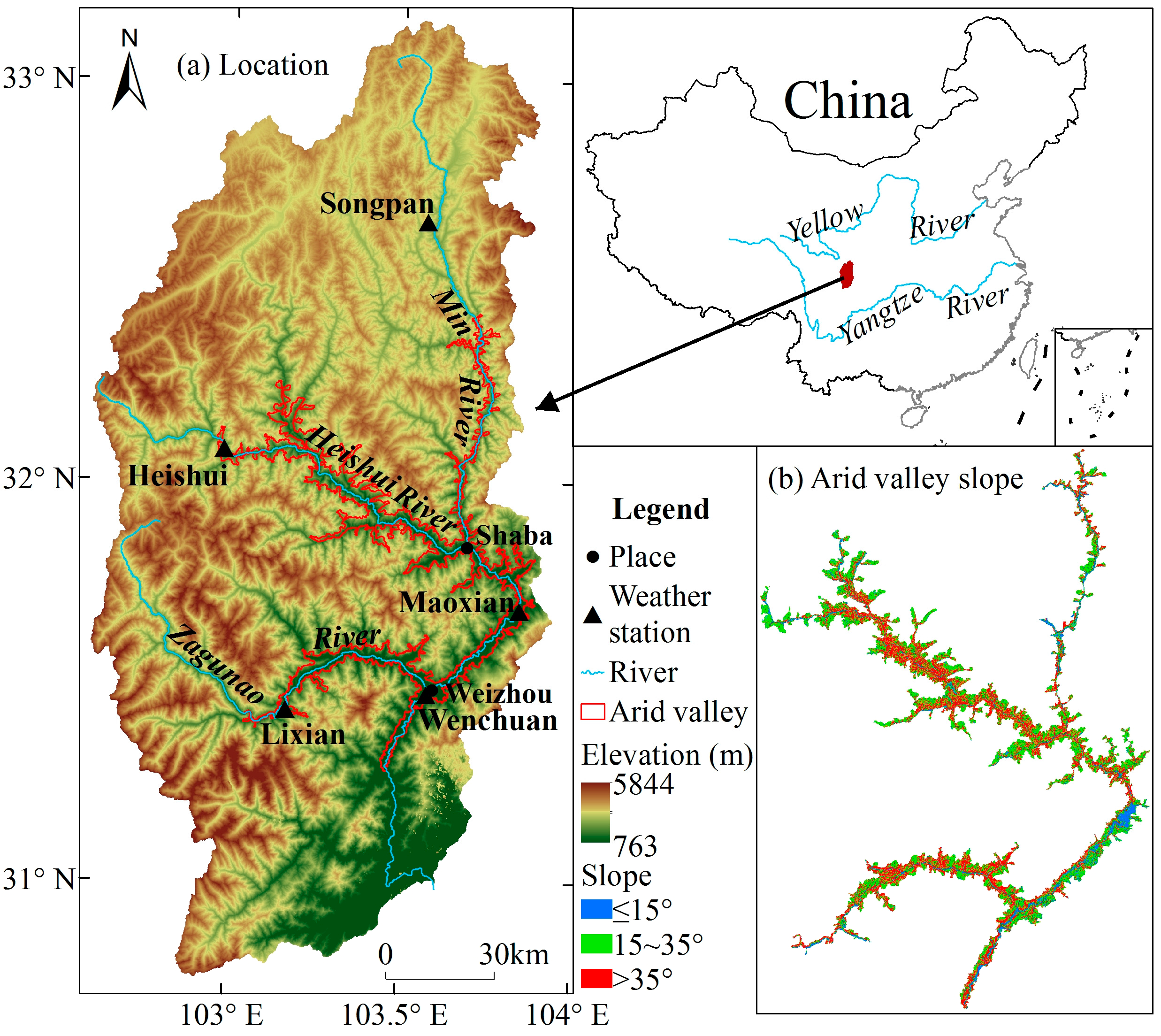
2. Study Area
3. Methods
3.1. Data Sources
3.2. Methods
3.2.1. Analysis on the Trend of Climate Change
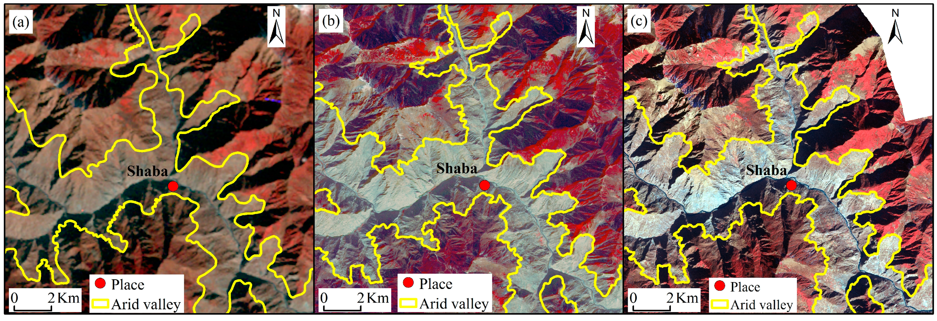
3.2.2. Interpretation of the Arid Valley Boundary and Calculation of its Displacement
4. Results and Discussion
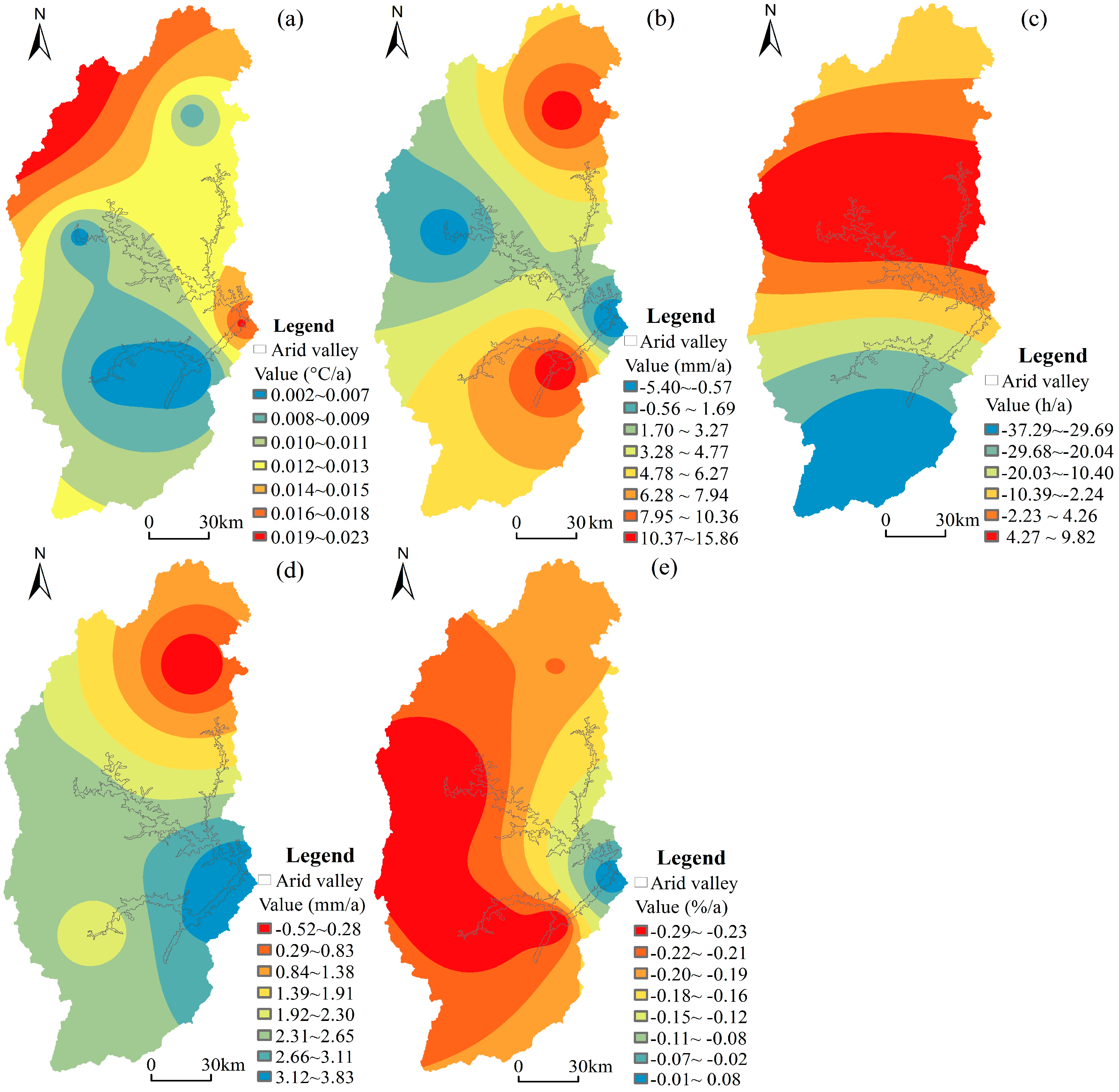
4.1. Characteristics of Climate Change
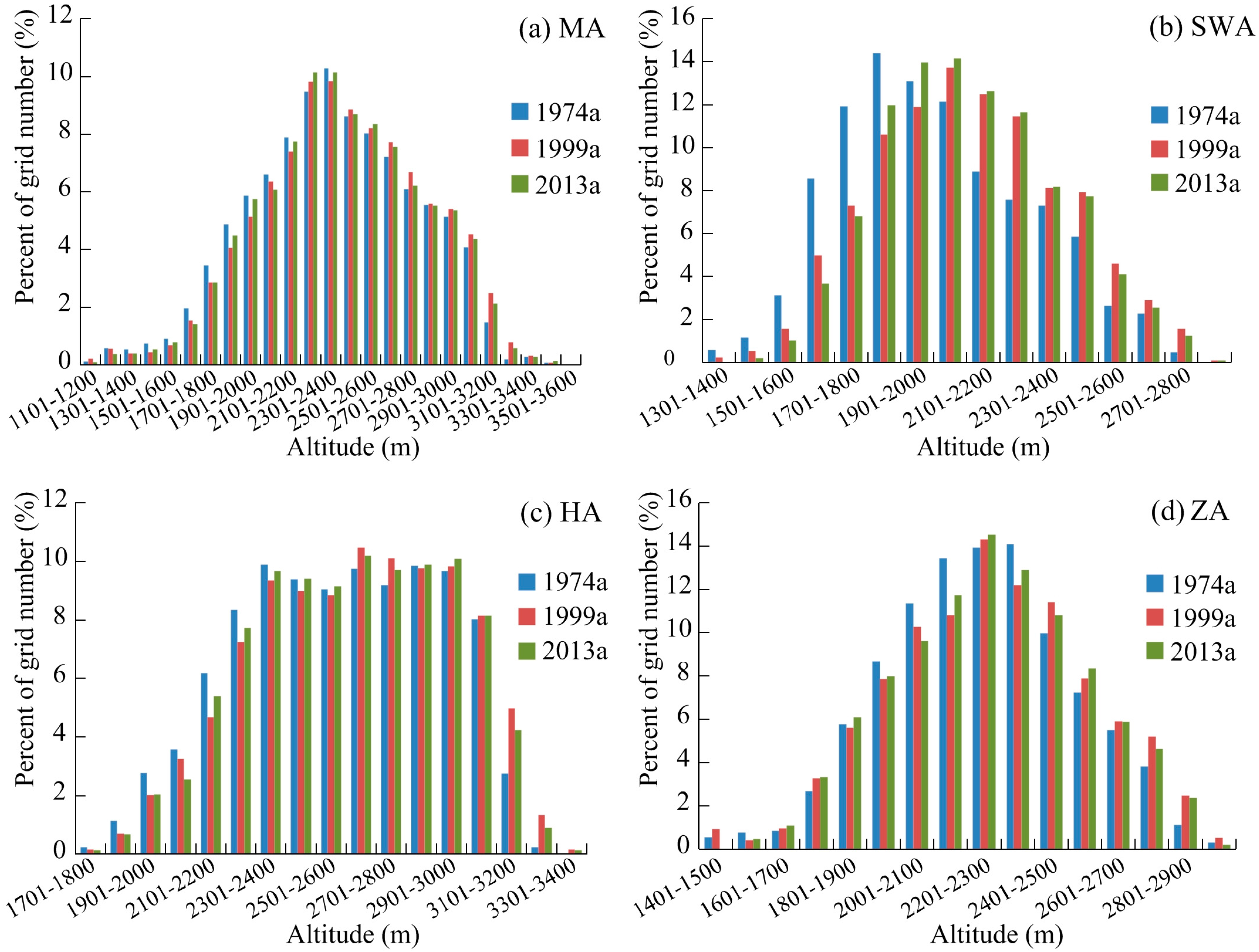
4.2. Vertical Displacement of the Arid Valley Boundary
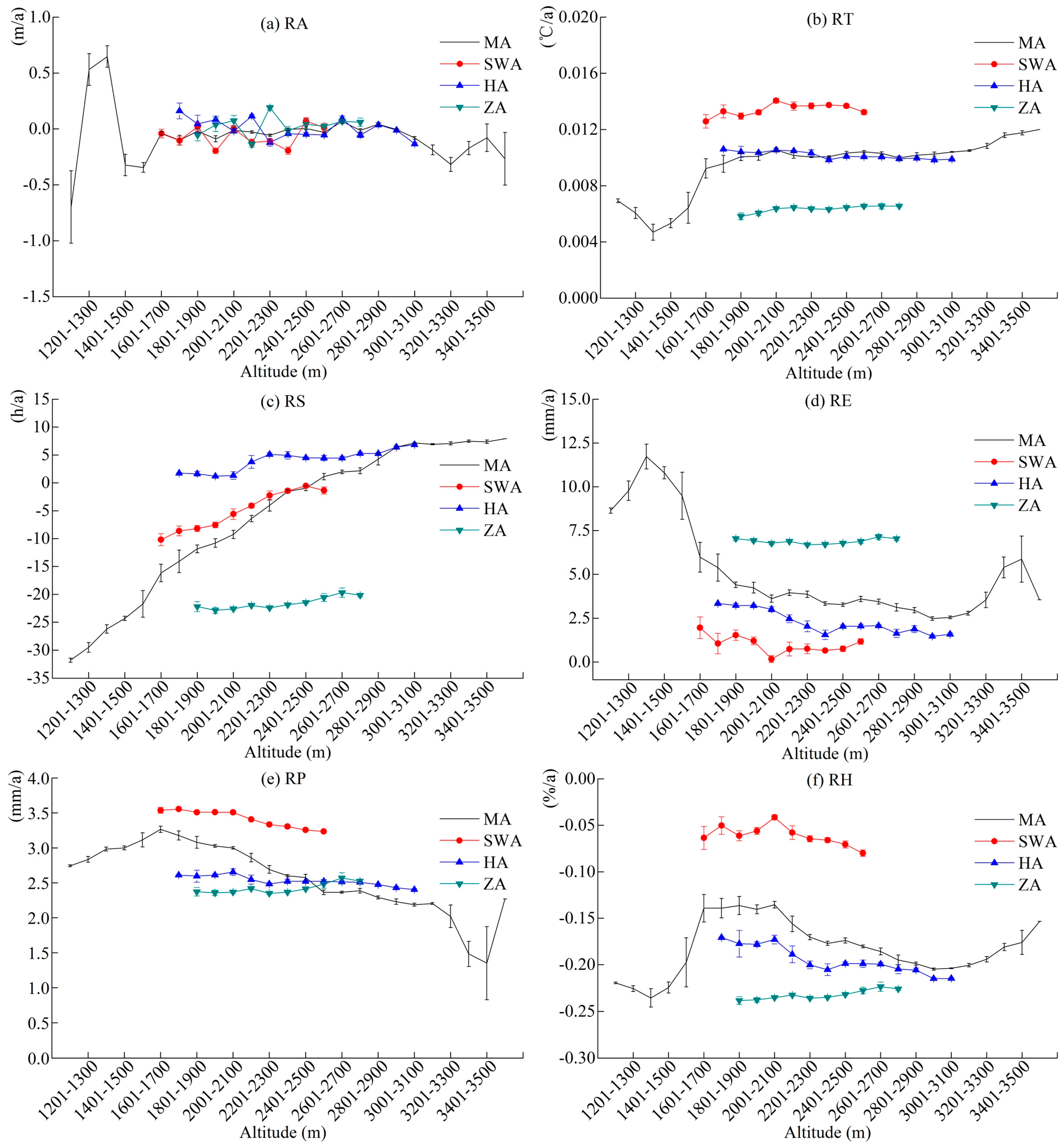
4.3. Relationship between the Arid Valley Boundary’s Displacement and Climate Change
4.3.1. Analysis of the Upper Reaches of the Min River
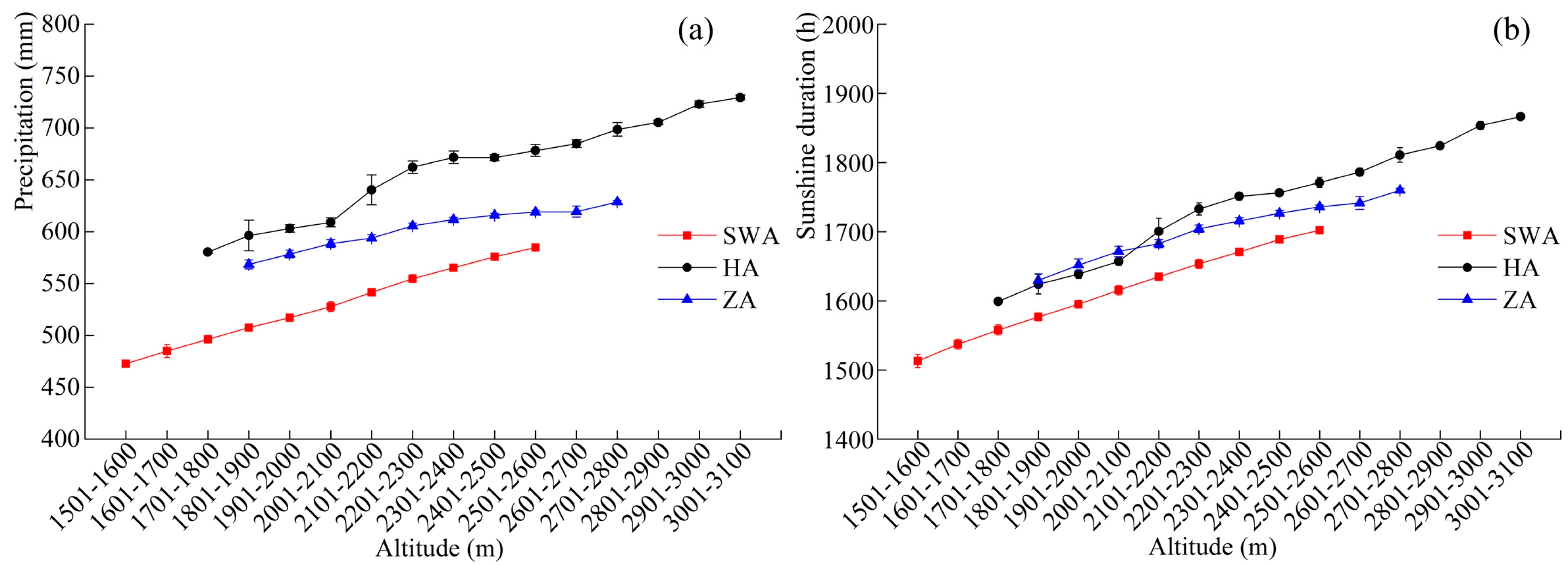
4.3.2. Analysis on the Three Regions
5. Conclusions
Acknowledgments
Author Contributions
Conflicts of Interest
References
- Yang, Q.Y.; Zhen, D.; Liu, Y.H. Physical–geographical feature and economic development of the dry valleys in the Hengduan Mountains, southwest China. J. Arid L. Resour. Environ. 1988, 2, 17–24. [Google Scholar]
- Zhang, R.Z. The Dry Valleys of the Hengduan Mountains Region; Science Press: Beijing, China, 1992. [Google Scholar]
- Yang, Z.P.; Chang, Y.; Bu, R.C.; Liu, M.; Zhang, W.G. Long–term dynamics of dry valleys in the upper reaches of Mingjiang River, China. Acta Ecol. Sin. 2007, 27, 3250–3256. [Google Scholar]
- Gao, Y.Y.; Liu, Q.; Wang, H.R.; Xu, X.Y.; Shi, Q.Y. Definition dry valleys scope by RS and GIS. J. Beijing Norm. Univ. 2012, 48, 92–96. [Google Scholar]
- Yuan, H.; Li, X.W.; Lin, Y. Arid river valley division research in Sichuan Province based on remote sensing. J. Sichuan Agric. Univ. 2013, 31, 182–187. [Google Scholar]
- Zhong, X.H. Progress tendency and forward domains of mountain environment studies. J. Mt. Sci. 2006, 24, 525–530. [Google Scholar]
- Fang, Y.P.; Qin, D.H.; Ding, Y.J. A review about the research on adaptability in climate change-Present situation and tendency. Arid. Zone Res. 2009, 26, 299–305. [Google Scholar] [CrossRef]
- Ming, Q.Z.; Shi, Z.T.; Deng, Y.J.; Dong, M. High gradient effects of mountain regions-Taking the effects of nature human landscape in the Hengduan Mountains for example. J. Glaciol. Geocryol. 2006, 28, 925–930. [Google Scholar]
- Kelly, A.E.; Goulden, M.L. Rapid shifts in plant distribution with recent climate change. Proc. Natl. Acad. Sci. USA 2008, 105, 11823–11826. [Google Scholar] [CrossRef] [PubMed]
- Kullman, L. Pine (Pinus sylvestris L.) tree–limit surveillance during recent decades, Central Sweden. Arctic Alp. Res. 1993, 25, 24–31. [Google Scholar] [CrossRef]
- Malanson, G.P. Complex responses to global change at alpine treeline. Phys. Geogr. 2001, 22, 333–342. [Google Scholar]
- Zhai, Z.; Wang, Q. The geography distribution pattern and spatial move of the lower timberline in the upper reaches of Minjiang River. Geogr. Res. 2015, 34, 2105–2112. [Google Scholar]
- Hantel, M.; Maurer, C.; Mayer, D. The snowline climate of the Alps 1961–2010. Theor. Appl. Climatol. 2012, 110, 517–537. [Google Scholar] [CrossRef]
- Mark, B.G.; Harrison, S.P.; Spessa, A.; New, M.; Evans, D.J.A.; Helmens, K.F. Tropical snowline changes at the last glacial maximum, A global assessment. Quat. Int. 2005, 138–139, 168–201. [Google Scholar] [CrossRef]
- Zhao, J.; Huang, Y.S.; Shi, Y.F.; Li, L. Relationship between snow line change and climate change in the middle of Qilian Mountains during 2000–2012. Mt. Res. 2015, 33, 683–689. [Google Scholar]
- Bao, W.K.; Wang, C.M. Degradation mechanism of mountain ecosystem at the dry valley in the upper reaches of the Minjiang River. J. Mt. Sci. 2000, 18, 57–62. [Google Scholar]
- Chen, G.J.; Tu, J.J.; Fan, H.; Ye, Y.Q.; Chen, Y. The Theory and Practice of Ecological Construction in the Upper Reaches of Minjiang River; Southwest China Normal University Press: Chongqing, China, 2006. [Google Scholar]
- Dong, Y.F.; Xiong, D.H.; Su, Z.A.; Li, J.J.; Yang, D.; Shi, L.T.; Liu, G.C. The distribution of and factors influencing the vegetation in a gully in the Dry-hot Valley of southwest China. Catena 2014, 116, 60–67. [Google Scholar] [CrossRef]
- Pang, X.Y.; Bao, W.K.; Wu, N. Reasons of dry valley climate characteristic and its formation reason in upstream of Minjiang River. Resour. Environ. Yangtze Basin 2008, 17, 46–53. [Google Scholar]
- Zheng, D.; Yang, Q.Y. Some problems on the altitudinal belts in Southeastern Qinghai–Xizang (Tibetan) Plateau. Acta Geogr. Sin. 1985, 40, 60–69. [Google Scholar]
- Wang, Q.; Shi, M.Q.; Guo, Y.L.; Zhang, Y. The vertical differentiation of the mountain settlement niche in the upper reaches of Minjiang River. Acta Geogr. Sin. 2013, 68, 1559–1567. [Google Scholar]
- Guan, W.B.; Ye, M.S.; Ma, K.M.; Liu, G.H.; Wang, X.L. Vegetation classification and the main types of vegetation of the Dry Valley of Minjiang River. J. Mt. Sci. 2004, 22, 679–686. [Google Scholar]
- Liu, L.H. Vegetation types of the arid valleys in the Hengduan Mountainous region. Mt. Res. 1989, 7, 175–182. [Google Scholar]
- Liu, W.B. Main types of the semi–arid valley scrubs in the upper reaches of the Minjiang River. Mt. Res. 1994, 12, 27–31. [Google Scholar]
- Yang, Q.Z. Study on the arid valley scrubs in the upper reaches of Minjiang River. J. Mt. Sci. 2007, 25, 1–32. [Google Scholar]
- Guo, Y.L.; Wang, Q.; Yan, W.P.; Zhou, Q.; Shi, M.Q. Assessment of habitat suitability in the Upper Reaches of the Min River in China. J. Mt. Sci. 2015, 12, 737–746. [Google Scholar] [CrossRef]
- Yao, J.; Ding, J.; Ai, N.S. Assessment of ecological vulnerability in upper reaches of Mingjiang River. Resour. Environ. Yangtze Basin 2004, 13, 380–383. [Google Scholar]
- Liu, W.B. Flora of semi–arid valley shrubs at the upper reaches of Minjiang River. Mt. Res. 1992, 10, 83–88. [Google Scholar]
- Fan, H.; Zhang, J.P. Study on land use/cover in arid valley of upper Minjiang watershed. J. Desert Res. 2002, 22, 273–278. [Google Scholar]
- Fan, M.; Li, F.C.; Guo, Y.L.; Wang, Q. Effects of Grain for Green Project on changes in ecosystems service values of alpine settlement area in the upper reaches of the Minjiang River. Mt. Res. 2016, 34, 356–365. [Google Scholar]
- Li, Z.X.; He, Y.Q.; Xin, H.J.; Wang, C.F.; Jia, W.X.; Zhang, W.; Liu, Q. Spatio–temporal variations of temperature and precipitation in Mts. Hengduan Region during 1960–2008. Acta Geogr. Sin. 2010, 65, 563–579. [Google Scholar]
- Moseley, R.K.; Tang, Y. Vegetation dynamics in the dry valleys of Yunnan, China, during the last 150 years: Implications for ecological restoration. Acta Phytoecol. Sin. 2006, 30, 713–722. [Google Scholar]
- Nan, X.; Yan, D.; Li, A.N.; Lei, G.B.; Cao, X.M. Mountain hazards risk zoning in the upper reaches of Minjiang River. J. Catastr. 2015, 30, 113–120. [Google Scholar]
- Ye, Y.Q.; Chen, G.J.; Fan, H. Impact of the “Grain for Green” project on rural community in the Upper Min River Basin, Sichuan, China. Mt. Res. Dev. 2003, 23, 35–41. [Google Scholar]
- Wei, F.Y. Modern Climatic Statistical Diagnosis and Prediction Technology; Meteorological Press: Beijing, China, 2007. [Google Scholar]
- Jiang, W.P.; Yuan, L.H.; Wang, W.J.; Cao, R.; Zhang, Y.F.; Shen, W.M. Spatio–temporal analysis of vegetation variation in the Yellow River Basin. Ecol. Indic. 2015, 51, 117–126. [Google Scholar] [CrossRef]
- Wu, S.H.; Yin, Y.H.; Zheng, D.; Yang, Q.Y. Climate changes in the Tibetan Plateau during the last three decades. Acta Geogr. Sin. 2005, 60, 3–11. [Google Scholar]
- Xu, Z.X.; Zhang, L.; Huang, J.X.; Gong, T.L. Long–term trend of temperature, precipitation and relative humidity in the Tibetan Region. Meteorol. Mon. 2007, 33, 82–88. [Google Scholar]
- Wang, Q.; Zhai, Z. The lower timberline dataset in the upper reaches of Minjiang River, China (1999–2009) (LowerTimberlineMinjiang_1999–2009). Glob. Chang. Res. Data Publ. Repos. 2016, 3. [Google Scholar] [CrossRef]
- Fang, Y.P.; Fan, J.; Shen, M.Y.; Song, M.Q. Sensitivity of livelihood strategy to livelihood capital in mountain areas: Empirical analysis based on different settlements in the upper reaches of the Minjiang River, China. Ecol. Indic. 2014, 38, 225–235. [Google Scholar] [CrossRef]


| Weather Station | North Latitude (°) | East Longitude (°) | Elevation (m) | AT (°C) | AP (mm) | AS (h) | AH (%) | AE (mm) |
|---|---|---|---|---|---|---|---|---|
| Wenchuan | 103.58 | 31.47 | 1453 | 14.63 | 467.20 | 1457.65 | 65.73 | 1401.99 |
| Lixian | 103.17 | 31.43 | 2139 | 11.70 | 591.87 | 1667.79 | 67.27 | 1448.86 |
| Maoxian | 103.85 | 31.68 | 1588 | 11.54 | 453.94 | 1558.91 | 74.13 | 1415.41 |
| Heishui | 102.98 | 32.08 | 2397 | 9.39 | 797.57 | 1891.73 | 64.40 | 1405.83 |
| Songpan | 103.57 | 32.65 | 3190 | 6.67 | 705.91 | 1747.43 | 62.20 | 1304.24 |
| Image | Acquisition Time | Resolution (m) | |
|---|---|---|---|
| Panchromatic Band | Multi-Spectral Band | ||
| Landsat MSS * | January, 1974 | / | 30 |
| SPOT-2/SPOT-4 | December, 1999; January, 2000 | 10 | 20 |
| SPOT-6 | January, 2014; February, 2014 | 1.5 | 6 |
| Weather Station | RT (°C/a) | RS (h/a) | RE (mm/a) | RP (mm/a) | RH (%/a) |
|---|---|---|---|---|---|
| Wenchuan | 0.002 | −22.34 | 15.86 | 3.17 | −0.26 * |
| Lixian | 0.005 | −25.67 * | 6.92 | 2.12 | −0.26 * |
| Maoxian | 0.018 | −5.24 | −5.40 | 3.84 | 0.08 |
| Heishui | 0.006 | 8.17 | −4.18 | 2.63 | −0.29 * |
| Songpan | 0.007 | 1.50 | 14.34 | −0.52 | −0.21 * |
| Whole Basin | 0.008 | −8.72 | 5.51 | 2.25 | −0.19 * |
| Regions | 1974a–1999a | 1999a–2013a | |
|---|---|---|---|
| MA | Average Elevation/m | 2402 ± 409 | 2401 ± 414 |
| Variation Rate/m/a | 1.72 ± 0.32 | −0.76 ± 0.26 | |
| SWA | Average Elevation/m | 2068 ± 287 | 2101 ± 280 |
| Variation Rate/m/a | 3.77 ± 0.28 | 0.02 ± 0.30 | |
| HA | Average Elevation/m | 2622 ± 325 | 2636 ± 327 |
| Variation Rate/m/a | 1.88 ± 0.19 | −0.68 ± 0.18 | |
| ZA | Average Elevation/m | 2274 ± 277 | 2270 ± 294 |
| Variation Rate/m/a | 1.00 ± 0.24 | −0.06 ± 0.35 |
| RA in Region | Altitude Range (m) | Temperature | Sunshine Duration | Evaporation | Precipitation | Relative Humidity | Regression Analysis |
|---|---|---|---|---|---|---|---|
| RA_MA | 1601‒3000 | −0.663 * | 0.658 * | −0.662* | 0.659 * | −0.654 * | RA= −0.013 × Y − 0.020, p = 0.010 < 0.05 |
| RA_HA | 1701‒3100 | 0.549 * | −0.567* | 0.536* | −0.583 * | 0.561 * | RA = 0.022 × Y + 0.003, p = 0.037 < 0.05 |
| RA in Region | Altitude Range (m) | RT | RS | RE | RP | RH | Regression Analysis |
|---|---|---|---|---|---|---|---|
| RA_MA | 1601‒3000 | 0.461 | 0.664 * | −0.607 * | −0.657 * | −0.612 * | RA= −0.014 × Y − 0.020, p = 0.010 < 0.05 |
| RA_SWA | 1601‒2600 | −0.083 | 0.101 | 0.074 | −0.176 | −0.219 | / |
| RA_HA | 1701‒3100 | 0.554 * | −0.605 * | 0.632 * | 0.552 * | 0.612 * | RA = 0.025 × Y + 0.003, p = 0.020 < 0.05 |
| RA_ZA | 1801‒2800 | 0.339 | 0.064 | −0.239 | 0.019 | 0.108 | / |
© 2017 by the authors. Licensee MDPI, Basel, Switzerland. This article is an open access article distributed under the terms and conditions of the Creative Commons Attribution (CC BY) license (http://creativecommons.org/licenses/by/4.0/).
Share and Cite
Guo, Y.; Wang, Q.; Fan, M. Exploring the Relationship between the Arid Valley Boundary’s Displacement and Climate Change during 1999–2013 in the Upper Reaches of the Min River, China. ISPRS Int. J. Geo-Inf. 2017, 6, 146. https://doi.org/10.3390/ijgi6050146
Guo Y, Wang Q, Fan M. Exploring the Relationship between the Arid Valley Boundary’s Displacement and Climate Change during 1999–2013 in the Upper Reaches of the Min River, China. ISPRS International Journal of Geo-Information. 2017; 6(5):146. https://doi.org/10.3390/ijgi6050146
Chicago/Turabian StyleGuo, Yalin, Qing Wang, and Min Fan. 2017. "Exploring the Relationship between the Arid Valley Boundary’s Displacement and Climate Change during 1999–2013 in the Upper Reaches of the Min River, China" ISPRS International Journal of Geo-Information 6, no. 5: 146. https://doi.org/10.3390/ijgi6050146
APA StyleGuo, Y., Wang, Q., & Fan, M. (2017). Exploring the Relationship between the Arid Valley Boundary’s Displacement and Climate Change during 1999–2013 in the Upper Reaches of the Min River, China. ISPRS International Journal of Geo-Information, 6(5), 146. https://doi.org/10.3390/ijgi6050146