WebGIS and Geospatial Technologies for Landscape Education on Personalized Learning Contexts


Abstract
:1. Introduction
2. The Educational Context
2.1. What to Learn
2.2. How to Learn
2.3. Who Will Learn
3. Objectives and Methodology
- To obtain a better understanding of the landscapes using different tools for spatial analysis.
- To increase digital and geospatial competencies to apply acquired knowledge to other geographic spaces and different landscapes.
- To encourage active student constructivist learning, building up their own knowledge.
- To apply territorial knowledge in daily life by acting wisely with responsibility for sustainable development.
- Perceiving and observing (territory), some key questions help these tasks.
- Using: Acquiring, exploring, organizing, analyzing, and interpreting outdoor and other geospatial technologies used.
- Analyzing layered map data to understand the complexity of the elements involved in the organization of territory (physical, social, economic, political, and cultural) resulting from their interaction.
- Structuring: Making sense of collected geographical information (geoinformation). Structuring spatial relations, such as identification, comparison, measurement, connections, directions, or hierarchy, among others.
- Applying: Acting on the correct and wise use of geographical knowledge (e.g., building new interactive maps with student’s own data and obtaining new research conclusions).
4. Learning Examples Based on Geotechnology, ICT, and Personalized Learning
4.1. Learning Landscape Using WebGIS
4.1.1. WebGIS on University Projects
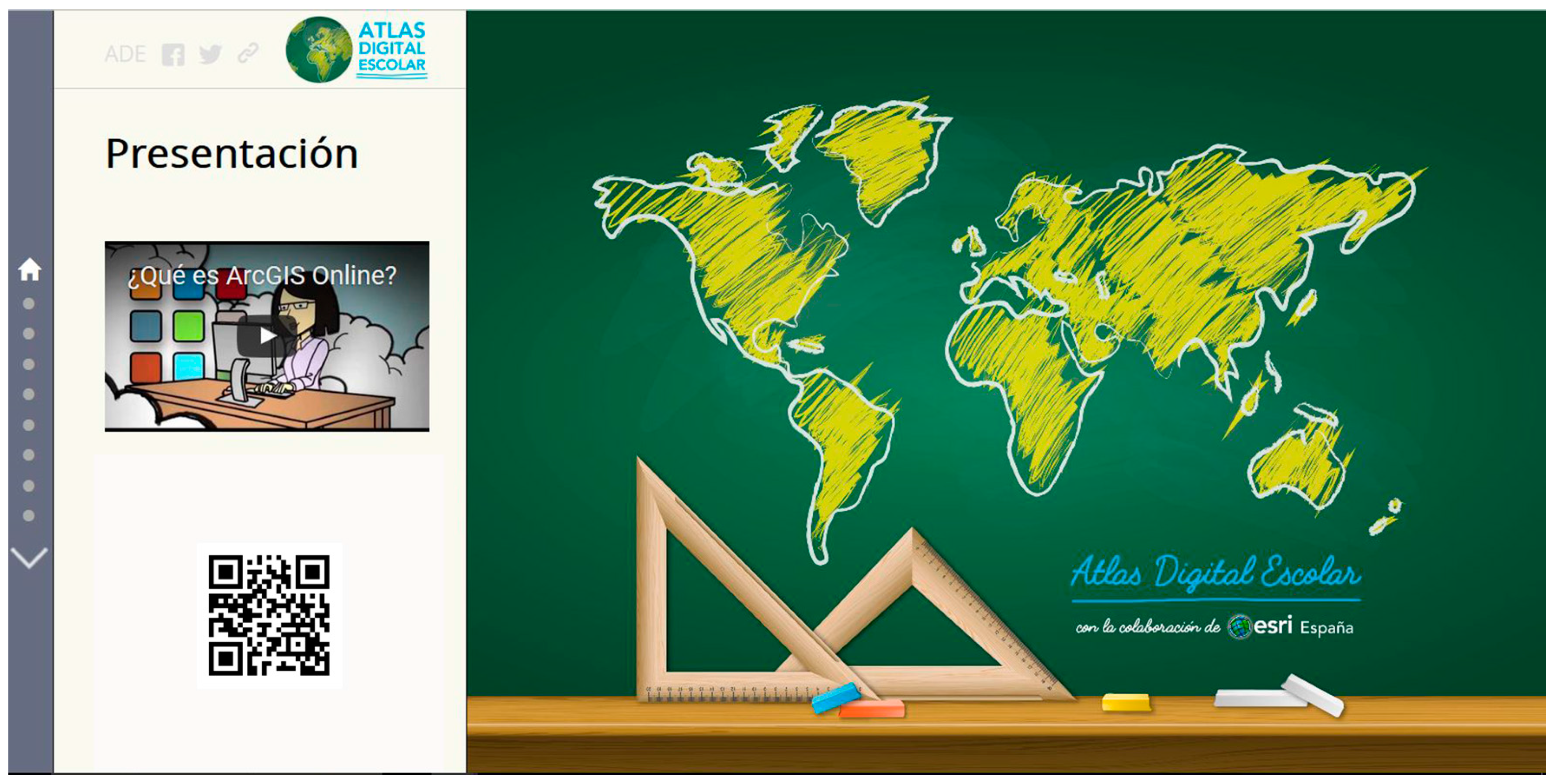
4.1.2. Digital Atlas for Schools
- Facilitating the acquisition of knowledge based on the geography curriculum.
- Encouraging critical geospatial thinking [49], providing a tool for spatial analysis.
- Understanding the concepts and reflected contents on any map, rather than memorizing it. This invites browsing to reach the same learning outcomes proposed by the current curriculum.
- Leveraging open and quality geodata available on the portals maintained by the official bodies responsible for the same data.
- Promoting learning standards and evaluation criteria that are useful for learning throughout life-centered and spatial reasoning, and acquiring digital skills.
- Learning how to properly integrate geolocation tools in pictures, maps, and other geo-data to help gain a better understanding of the Earth, through its analysis and by drawing the right conclusions for actions to be taken.
- Forming a citizenship whose responsibility is to apply acquired knowledge. Study cases and school experiences will be proposed with this aim in mind.
- Serving as a laboratory instrument for geography education research in at least two ways: geospatial thinking and GeoProgressions [50].
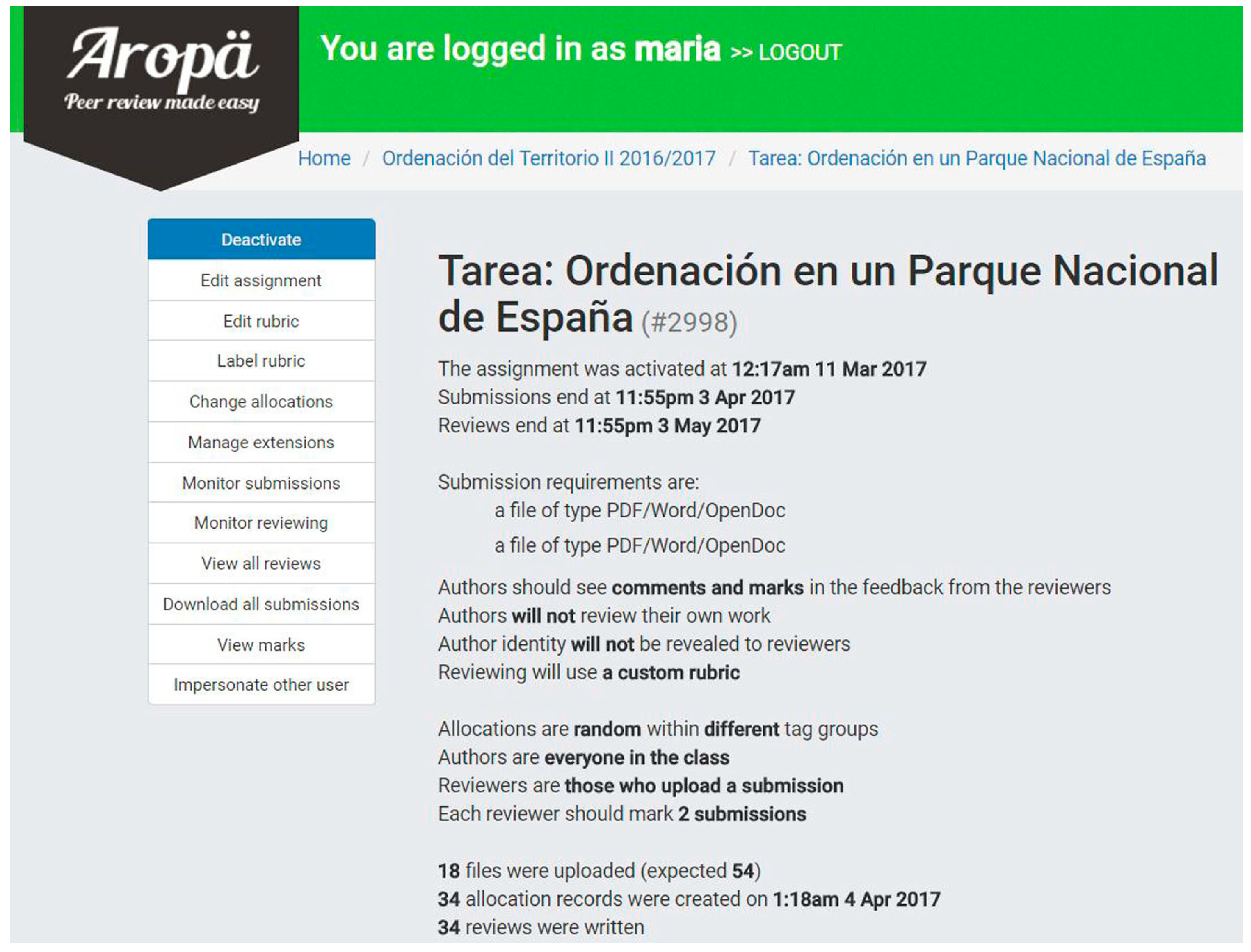
4.2. The Aropä Learning Environment and a Landscape Approach
4.3. The Use of the Portfolio and Landscape Study
5. Meta-Analysis of the Learning Experiences on Personalized Learning Indicators
6. Conclusions
Acknowledgments
Author Contributions
Conflicts of Interest
Appendix A
- “Enseñar Geografía a través del análisis de imágenes con la ayuda del Campus Virtual y la Pizarra Digital Interactiva (PDI)” (Teaching Geography and image analysis using Virtual Campus and the Interactive Whiteboard, IWB), PIMCD 6/2010. (Coordinator Dr. Dª María Luisa de Lázaro y Torres). Available online: <http://eprints.ucm.es/16849/> (accessed on 11 September 2017).
- “Aprender Geografía con la web 2.0” (Learning Geography using 2.0 Web). PIMCD 133/ 2011. (Coordinator Dr. Dª María Luisa de Lázaro y Torres). Available online: <http://eprints.ucm.es/21217/> (accessed on 11 September 2017).
- “Aprender Geografía de España con la web 2.0” (Learning Spanish geography on the Web 2.0). PIMCD 165/ 2013. (Coordinator Dr. D. Miguel Ángel Alcolea Moratilla). Available online: <http://eprints.ucm.es/27995/> (accessed on 11 September 2017).
- “Aprender Geografía con la web 2.0 a través de la evolución de los paisajes agrarios de España”( Learning Geography with the 2.0 Web and Spanish agrarian landscapes changes). PIMCD 98/ 2014. (Coordinator Dr. Dª María Luisa de Lázaro y Torres). Available online: <http://eprints.ucm.es/28547/> (accessed on 11 September 2017).
- “La potencialidad de la nube para el trabajo de campo en Geografía: El Parque Nacional de la Sierra de Guadarrama” (The challenge of the Cloud for fieldwork in geography: the Sierra de Guadarrama National Park). PIMCD 224/2015. (Coordinator Dr. D. José Manuel Crespo Castellanos). Available online: <http://eprints.ucm.es/35335/> (accessed on 11 September 2017).
- “Aplicación de las tecnologías de la información geográfica en el diseño de itinerarios para la educación en paisaje en el ámbito de los Parques Nacionales Españoles”(Application of GeoICT in the design of itineraries for landscape education in the field of Spanish National Parks). PIMCD 52/2016. (Coordinator Dr. D. José Manuel Crespo Castellanos.)
References
- Thompson, D.; Lindsay, F.E.; Davis, P.E.; Wong, D.W. Towards a framework for learning with GIS: The case of urban world, a hypermap learning environment based on GIS. Trans. GIS 1997, 2, 151–167. [Google Scholar] [CrossRef]
- Silavi, T.; Hakimpour, F.; Claramunt, C.; Nourian, F. The Legibility and Permeability of Cities: Examining the Role of Spatial Data and Metrics. ISPRS Int. J. Geo-Inf. 2017, 6, 101. [Google Scholar] [CrossRef]
- De Miguel, R.; De Lázaro, M.L. Educating geographers in Spain. Geography teaching renewal by implementing the European Higher Education Area. J. Geogr. High. Educ. 2016, 40, 267–283. [Google Scholar] [CrossRef]
- Favier, T.T.; Van Der Schee, J.A. The effects of geography lessons with geospatial technologies on the development of high school students’ relational thinking. Comput. Educ. 2014, 76, 225–236. [Google Scholar] [CrossRef]
- Baker, T.R.; Battersby, S.; Bednarz, S.W.; Bodzin, A.M.; Kolvoord, B.; Moore, S.; Sinton, D.; Uttal, D.A. Research Agenda for Geospatial Technologies and Learning. J. Geogr. 2015, 114, 11–130. [Google Scholar] [CrossRef]
- Carbonell, C.; Bermejo, L.A. Augmented reality as a digital teaching environment to develop spatial thinking. Cartogr. Geogr. Inf. Sci. 2017, 44, 259–270. [Google Scholar] [CrossRef]
- Carbonell, C.; Avarvarei, B.V.; Chelariu, E.L.; Draghia, L.; Avarvarei, S.C. Map-Reading Skill Development with 3D Technologies. J. Geogr. 2017, 116, 197–205. [Google Scholar] [CrossRef]
- Elosúa, M.R. El aprendizaje significativo desde un enfoque social. Revista de Psicología Universitas Tarraconensis 1992, 2, 7–16. [Google Scholar]
- Europe, C.O. Convención Europea del Paisaje; Council of Europe: Florence, Italy, 2000. [Google Scholar]
- Crespo Castellanos, J.M. La Educación en Paisaje en el Grado de Maestro de Educación Primaria: Una Propuesta de Modelo Didáctico (Landscape Education in Primary Teacher’s Degree: A Didactic Model proposal). Ph.D. Thesis, Complutense University of Madrid, Madrid, Spain, 23 June 2017. [Google Scholar]
- Observatorio de Educación Patrimonial en España (OEPE) (Web of the Observatory of Heritage Education in Spain). Ministerio de Economía-FECYT. Available online: http://www.oepe.es/ (accessed on 19 August 2017).
- Fontal, O.; Ibáñez, A. Estrategias e instrumentos para la educación patrimonial en España. Educatio Siglo XXI 2015, 33, 15–32. [Google Scholar] [CrossRef]
- Pereira, N. Educación Personalizada: Un Proyecto Pedagógico en Pierre Faure; Narcea: Madrid, Spain, 1976. [Google Scholar]
- Kerski, J.J. Sleepwalking into the Future—The Case for Spatial Analysis Throughout Education. In Learning with GI 2011; Jekel, T., Koller, A., Donert, K., Vogler, R., Eds.; Herbert Wichmann Verlag: Berlin/Offenbach, Germany, 2011. [Google Scholar]
- Favier, T.; Van Der Schee, J. Exploring the characteristics of an optimal design for inquiry-based geography education with Geographic Information Systems. Comput. Educ. 2012, 58, 666–677. [Google Scholar] [CrossRef]
- Buzo, I. Incorporación de un WebSIG a la enseñanza de la Geografía en 3° de ESO. In Actas XVI Congreso Nacional de Tecnologías de la Información Geográfica; Universidad de Alicante: Alicante, Spain, 2014; pp. 711–720. [Google Scholar]
- De Lázaro, M.L.; De Miguel, R.; González, M.J. Flipped teaching: A useful method for cloud-based GIScience learning. In Educational Design and Cloud Computing in Modern Classroom Settings; Doukas, K., Kostopoulos, K., Eds.; IGI Global: Hershey, PA, USA, 2017; accepted. [Google Scholar]
- Sams, A.; Bergmann, J. Flip Your Classroom: Reach Every Student in Every Class Every Day; International Society for Technology in Education/ISTE: Arlington, VA, USA, 2012. [Google Scholar]
- Mitra, S. SOLE Toolkit: How to Bring Self-Organized Learning Environments to Your Community. Available online: http://media.ted.com/storage/prize/SOLEToolkit.pdf (accessed on 11 June 2013).
- European Union. Recommendation of the European Parliament and of the Council of 18 December 2006 on Key Competences for Lifelong Learning (2006/962/EC). Off. J. Eur. Union 2006, L394/10–L394/18. [Google Scholar]
- Adams Becker, S.; Cummins, M.; Davis, A.; Freeman, A.; Hall Giesinger, C.; Ananthanarayanan, V. NMC Horizon Report: 2017 Higher Education Edition; The New Media Consortium: Austin, TX, USA, 2017. [Google Scholar]
- Mishra, P.; Koehler, M.J. Technological pedagogical content knowledge: A framework for integrating technology in teacher knowledge. Teach. Coll. Rec. 2006, 108, 1017–1054. [Google Scholar] [CrossRef]
- Mishra, P.; Koehler, M.J. What is technological pedagogical content knowledge (TPACK)? Cont. Issues Technol. Teach. Educ. 2009, 9, 60–70. [Google Scholar]
- Su, X.; Huang, X.; Zhou, C.; Chang, M. A Technological Pedagogical Content Knowledge (TPACK) Scale for Geography Teachers in Senior High School. Egitim ve Bilim 2017, 42, 325–341. [Google Scholar] [CrossRef]
- Doering, A.; Koseoglu, S.; Scharber, C.; Henrickson, J.; Lanegran, D. Technology integration in K-12 geography education using TPACK as a conceptual model. J. Geogr. 2014, 113, 223–237. [Google Scholar] [CrossRef]
- Mohd, C.K.; Nuraini, C.K.; Shahbodin, F.; Pee, N.C.; Hanapi, C. Personalized learning environment (PLE) experience in the 21st century: Review of literature. In Third World Congress on Information and Communication Technologies (WICT 2014); MITC: Melaka, Malaysia, 2014; Available online: http://eprints.utem.edu.my/13777/ (accessed on 19 August 2017).
- Cejas León, R.; Navío Gámez, A.; Barroso Osuna, J. Las competencias del profesorado universitario desde el modelo TPACK (conocimiento tecnológico y pedagógico del contenido). Pixel-Bit Revista de Medios y Educación 2016, 49, 105–199. [Google Scholar] [CrossRef]
- Álvarez, J.; De Lázaro, M.L. Spatial Data Infrastructure and Learning Geography. Eur. J. Geogr. 2017, 8, 19–29. [Google Scholar]
- Krathwohl, D.R. A revision of Bloom's taxonomy: An overview. Theory Pract. 2002, 41, 212–218. [Google Scholar] [CrossRef]
- Purchase, H.C.; Hamer, J. Peer Review in Practice: Eight years of experiences with Aropä. School of Computing Science, University of Glasgow. Assess. Eval. High. Educ. 2017, 1–15. [Google Scholar] [CrossRef]
- Fidalgo, Á.; Sein-Echaluce, M.L.; Lerís, D.; Castañeda, O. Teaching Innova Project: The Incorporation of Adaptable Outcomes in Order to Grade Training Adaptability. J. UCS 2013, 19, 1500–1521. [Google Scholar]
- Dziuban, C.; Moskal, P.; Johnson, C.; Evans, D. Adaptive Learning: A Tale of Two Contexts. Curr. Issues Emerg. eLearning 2017, 4, 3. [Google Scholar]
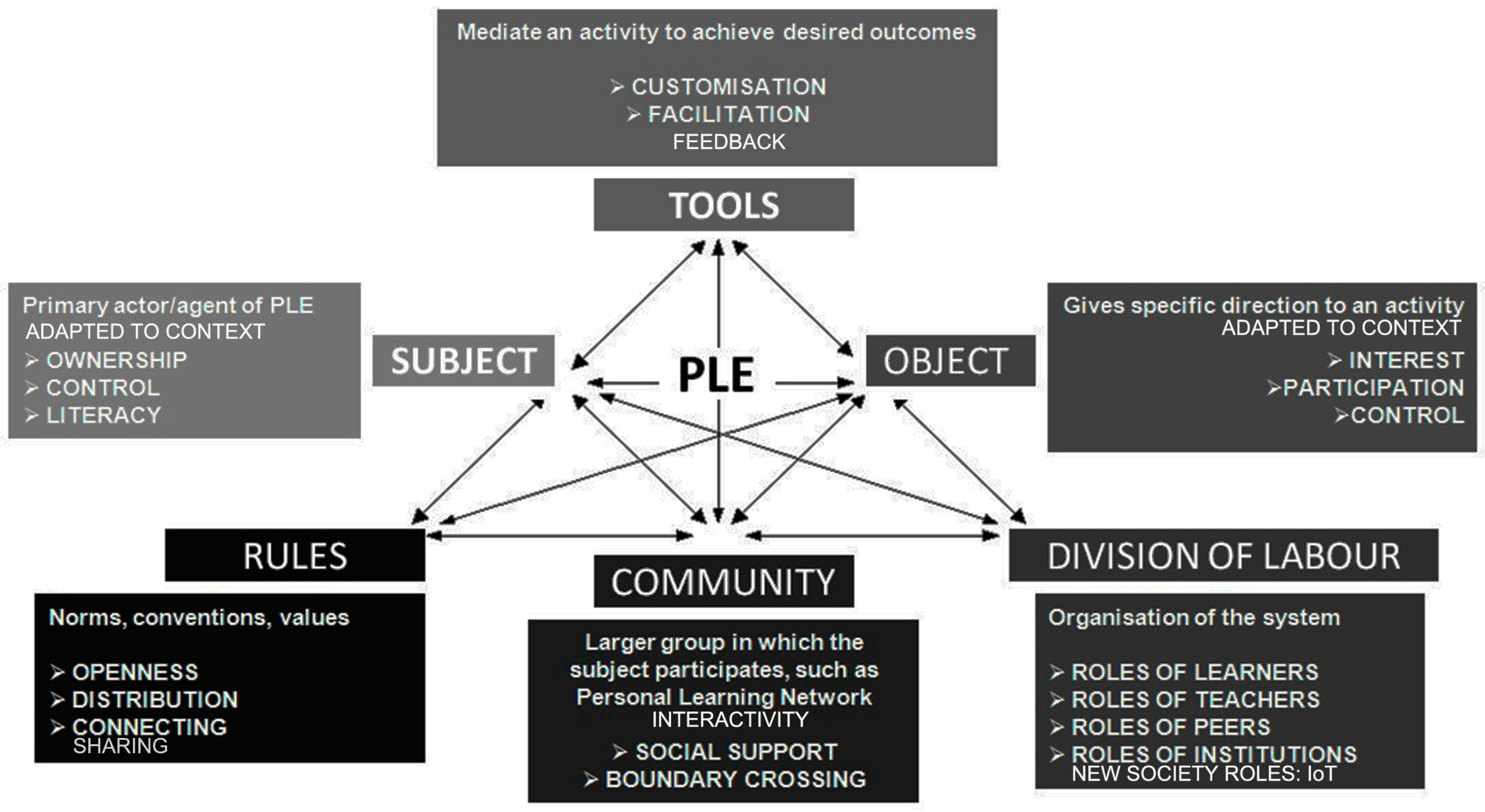
- Buchem, I.; Attwell, G.; Torres, R. Understanding personal learning environments: Literature review and synthesis through the activity theory lens. In Proceedings of the PLE Conference 2011, Southampton, UK, 10–12 July 2011; pp. 1–33. Available online: http://journal.webscience.org/658/ (accessed on 19 August 2017).
- Lázaro, M.L.; De Miguel, R.; Buzo, I. El proyecto School on the Cloud: Lecciones aprendidas (School on the Cloud project: lessons learned). Espacio Tiempo y Forma Serie VI Geografía 2017, 345–362. [Google Scholar] [CrossRef]
- Martinez, M. Key design considerations for personalized learning on the web. Educ. Technol. Soc. 2001, 4, 26–40. [Google Scholar]
- Lázaro, M.L.; Buzo, I. Aprender empleando SIGWebs. In IX Jornadas de Redes de Investigación en Innovación Docente de la UNED. La Profesionalización del Docente a Través de la Innovación Educativa; UNED: Madrid, Spain, 2017; in press. [Google Scholar]
- Lwin, K.K.; Murayama, Y. Web-based GIS system for real-time field data collection using personal mobile phone. J. Geogr. Inf. Syst. 2011, 3, 382–389. [Google Scholar] [CrossRef]
- Milson, A.J. GIS in the Cloud: Using WebGIS for Teaching Secondary Geography. Didáctica Geográfica 2011, 12, 151–153. [Google Scholar]
- GeoSkills Plus Project. Landmeter: Revue Trimestrielle de l’Union Belge des Géomètres-Experts et l’Association Nationale des Géomètres-Experts. 2015. Available online: http://www.obge-bole.be/GetDocument.ashx?nr=1033 (accessed on 19 August 2017).
- Lázaro y Torres, M.L.; González González, M.J.; Mínguez García, M.C.; Mecha López, R.; Palacios Estremera, M.T.; Ruiz Palomeque, M.E. Enseñar Geografía a Través del Análisis de Imágenes con la Ayuda del Campus Virtual y la Pizarra Digital Interactiva (PIMCD 6/2010); Cersa: Madrid, Spain, 2012; Available online: http://eprints.ucm.es/16849/ (accessed on 19 August 2017).
- Alcolea Moratilla, M.A.; Buzo Sánchez, I.; Crespo Castellanos, J.M.; Cruz Naïmi, L.A.; De Lázaro y Torres, M.L.; De Miguel González, R.; Delgado Peña, J.J.; Gómez Ruiz, M.L.; González Castañé, M.; González González, M.J.; et al. Aprender Geografía de España con la Web 2.0; Vicerrectorado de Evaluación de la Calidad de la Universidad Complutense de Madrid: Madrid, Spain, 2014; Available online: http://eprints.ucm.es/27995 (accessed on 19 August 2017).
- Lázaro y Torres, M.L.; Alcolea Moratilla, M.A.; Buzo Sánchez, I.; Crespo Castellanos, J.M.; Cruz Naïmi, L.A.; De Miguel González, R.; Delgado Peña, J.J.; Gómez Ruiz, M.L.; González González, M.J.; Guallart Moreno, C.; et al. Aprender Geografía con la Web 2.0 a Través de la Evolución de los Paisajes Agrarios de España; Universidad Complutense de Madrid: Madrid, Spain, 2015; Available online: http://eprints.ucm.es/28547/ (accessed on 19 August 2017).
- Lázaro, M.L.; Izquierdo, S.; González, M.J. Geodatos y paisaje: De la nube al aula universitaria (Geodata and landscape: From the Cloud to Lectures). Boletín de la Asociación de Geógrafos Españoles 2016, 70, 371–391. [Google Scholar] [CrossRef]
- Buzo, I.; De Miguel, R.; De Lázaro, M.L. Learning on the cloud about changes to rural landscape and ArcGIS Online. In Proceedings of the 6th International Conference on Education and New Learning Technologies, Barcelona, Spain, 7–9 July 2014; pp. 248–255. [Google Scholar]
- Álvarez, J.; De Lázaro, M.L.; González, M.J. A Cloud-based GIScience Learning Approach to Spanish National Parks. Eur. J. Geogr. 2017. under review. [Google Scholar]
- De Miguel, R.; De Lázaro, M.L.; Velilla, J.; Buzo, I.; Guallart, C. Atlas Digital Escolar: Internet, Geografía y Educación. In Ar@cne. Revista Electrónica de Recursos de Internet Sobre Geografía y Ciencias Sociales; Universidad de Barcelona: Barcelona, Spain, 2016; Available online: http://www.ub.edu/geocrit/aracne/aracne-212.pdf (accessed on 19 August 2017).
- ESRI. What Is ArcGIS Online? Available online: http://doc.arcgis.com/en/arcgis-online/reference/what-is-agol.htm (accessed on 28 October 2017).
- De Miguel, R.; Buzo, I.; De Lázaro, M.L. New challenges for geographical education and researching: The Digital School Atlas. In Crisis, Globalization and Social and Regional Imbalances in Spain; Spanish Contribution to 33rd IGU Congress Beijing 2016; pp. 187–197. Available online: http://www.age-geografia.es/site/wp-content/uploads/2016/07/crisis_globlalization_UGI_eng_2016_WEB.pdf (accessed on 19 August 2017).
- Kim, M.; Bednarz, R. Development of critical spatial thinking through GIS learning. J. Geogr. High. Educ. 2013, 37, 350–366. [Google Scholar] [CrossRef]
- Solem, M.; Huynh, N.T.; Boehm, R. Learning Progressions for Maps, Geospatial Technology, and Spatial Thinking: A Research Handbook; Cambridge Scholars Publishing and Association of American Geographers: Washington, DC, USA, 2015. [Google Scholar]
- Lázaro, M.L.; Morales, F.J.; Zárate, M.A. La valoración del paisaje en el marco del aprendizaje personalizado y la educación a distancia (Landscape assessment in the framework of personalized learning and distance education). In Proceedings of the XXV Congreso de la AGE (Spanish Geographical Association) “Naturaleza, Territorio y Ciudad en un Mundo Global”, Madrid, Spain, 25–27 October 2017; pp. 2690–2699. [Google Scholar]
- Hamer, J.; Luxton-Reilly, A.; Purchase, H.C.; Sheard, J. Tools for contributing student learning. ACM Inroads 2011, 2, 78–91. [Google Scholar] [CrossRef]
- Hamer, J.; Purchase, H.; Luxton-Reilly, A.; Denny, P. A Comparison of Peer and Tutor Feedback. Assess. Eval. High. Educ. 2015, 40, 151–164. [Google Scholar] [CrossRef]
- Hamer, J.; Purchase, H.C.; Denny, P.; Luxton-Reilly, A. Quality of peer assessment in CS1. In Proceedings of the Fifth International Workshop on Computing Education Research Workshop, Berkeley, CA, USA, 10–11 August 2009; pp. 27–36. [Google Scholar]
- Pérez, R. El Portfolio. Aprendizajes, Competencias y Evaluación; UNED: Madrid, Spain, 2012. [Google Scholar]
- Calero, A.; Calero, E. El portfolio como estrategia de evaluación compartida de la comprensión lectora. Didáctica. Lengua y Literatura 2008, 15–36. [Google Scholar] [CrossRef]
- Barberà, E. El Estilo E-Portafolio; Editorial UOC: Barcelona, Spain, 2008. [Google Scholar]
- Barberà, E.; Gewerc Barujel, A.; Rodríguez Illera, J. Portafolios electrónicos y educación superior en España: Situación y tendencias. Revista de Educación a Distancia 2016. [Google Scholar] [CrossRef]
- Morales, F.J. La incorporación de los portafolios electrónicos en el proceso de enseñanza-aprendizaje y evaluación de la Geografía en el alumnado de educación a distancia (The incorporation of electronic portfolios learning in geography and evaluation process in distance). Espacio, Tiempo y Forma. Serie VI. Geografía 2016, 231–240. [Google Scholar] [CrossRef]
- Agra, M.J.; Gewerc, A.; Montero, L. El portafolio como herramienta de análisis en experiencias de formación on line y presenciales (The portfolio as an analysis instrument for on-line and educational experiences). Enseñanza Teach. 2003, 21, 101–114. [Google Scholar]
- Morales, F.J. El portfolio electrónico como recurso didáctico en Geografía. Análisis y valoración por alumnado del máster universitario de investigación en la UNED. In Actas del XVIII Congreso Internacional de Didáctica de las Ciencias Sociales; Universidad de Córdoba: Andalusia, Spain, 2017; pp. 697–707. [Google Scholar]
- Zárate, M.A. Imágenes mentales del Centro de Madrid, el barrio de Lavapiés. Boletín de la Real Sociedad Geográfica 2001, CXXXVII, 403–423. [Google Scholar]
- Zárate, M.A. Paisajes culturales urbanos, oportunidad para la conservación del patrimonio y el turismo sostenible. Estudios Geográficos 2017, 77, 693–728. [Google Scholar] [CrossRef]
- George, D.; Mallery, P. SPSS for Windows Step by Step: A Simple Guide and Reference, 11.0 Atualização (4a edição); Allyn & Bacon: Boston, MA, USA, 2003. [Google Scholar]
- Zwartjes, L. Guidance on Personalised Learning and the Cloud. 2016. Available online: http://www.schoolonthecloud.net/copy-of-case-studies-of-personalise (accessed on 19 August 2017).
- Muñiz Solari, O.; Demirci, A.; Van der Schee, J. Geospatial Technologies and Geography Education in a Changing World: Geospatial Practices and Lessons Learned; Springer: New York, NY, USA, 2015; 221p. [Google Scholar]


| Title (No/Year) No Downloads | Main Topic | Approach to Spanish Landscape | Tools |
|---|---|---|---|
| Teaching Geography, image analysis, Virtual Campus and the Interactive Whiteboard (IWB) (6/2010) 2816 | Analysis of 66 landscape images | Observation, analysis and commentary of landscape elements and units; relationship with the sustainable economy and with society (equilibrium or imbalance of that landscape with its environment and with economic development). | AGOL WebGIS, Google Earth, Picasa, Moodle virtual campus, IWB |
| Learning Geography using 2.0 Web (133/2011) 721 | Analysis of 55 landscape images | Observation, analysis and commentary of landscape elements and units; environmental, economic and social sustainability. Creation of 4 videos (3 lithology, 1 on dehesa). | Web site, Moodle virtual campus |
| Learning Spanish geography on the Web 2.0 (165/2013) 218 | Itineraries on patrimonial and natural landscapes | Observation, analysis, comment and assessment of landscapes creating itineraries to be carried out on foot with a maximum duration of 4–6 h. Images representative of georeferenced points of interest. | AGOL WebGIS, Iberpix, Moodle virtual campus |
| Learning Geography with the 2.0 Web and Spanish agrarian landscapes changes (98/2014) 662 | Agrarian landscapes images (34 analyzed by teachers/50 by students) | Observation, analysis, comment and assessment of agrarian landscapes. Title of the image, location; general description of the agrarian landscape in its agricultural context and protective figures, assessment and future prospects, problems and sustainability. | AGOL WebGIS, Moodle virtual campus |
| The challenge of the Cloud for fieldwork: the Sierra de Guadarrama N.P.l (224/2015) 53 | 4 Itineraries around this National Park | Itinerary description; accessibility; topographic profile; panoramic image; objectives and competencies of each itinerary; points of interest: geolocated image, explanation and activities; references. | AGOL WebGIS, Moodle virtual campus |
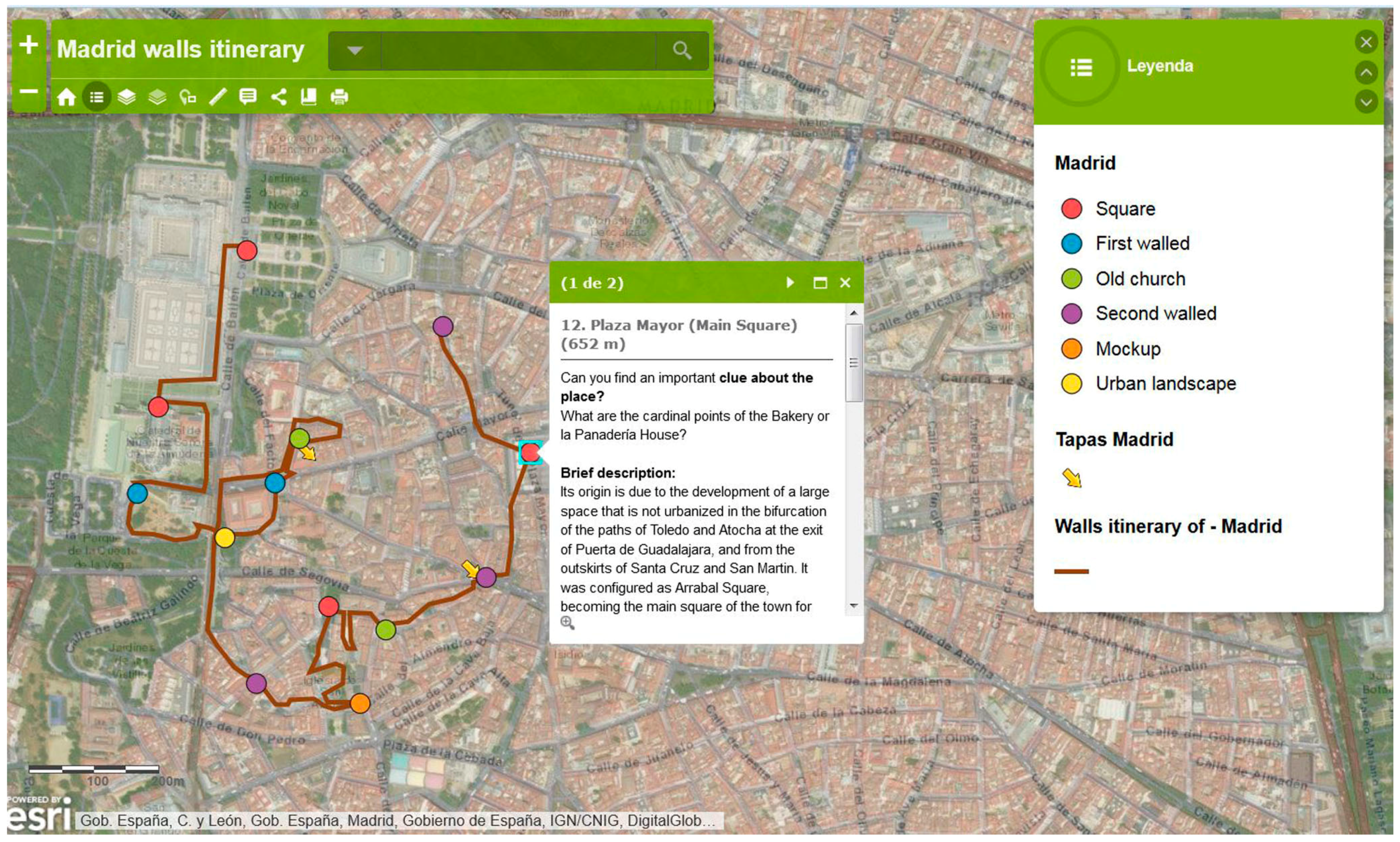
| Application of GeoICT in the design of itineraries for landscape education in the field of Spanish National Parks (52/2016) n.d. | Itineraries inside each of the 15 Spanish National Parks | General description of each park, problems; itinerary, accessibility, topographic profile, panoramic image, points of geographic didactic interest, geolocated image of each of them including general explanation, objectives, activities and other aspects; bibliographic references and web pages. | AGOL WebGIS, Moodle virtual campus |
| No. | Rubric | Score |
|---|---|---|
| 1 | Meets the standards of the requested work | 1 |
| 2 | The title chosen is attractive and according to the central topic | 1 |
| 3 | Provide relevant information on the topic | 1 |
| 4 | Deal with the main physical characteristics of the national park | 1 |
| 5 | Provide coherent discourse, clarity of ideas and argumentation; the theme or aspects developed are correctly focused | 1 |
| 6 | Apply concept learned on the theme: (choose one) | |
| ‒ very good: covers everything, comprehensive, outstanding; | 2 | |
| ‒ good: covers most things, | 1 | |
| ‒ just adequate: some gaps; | 1 | |
| ‒ poor: inadequate, shoes a lack of understanding) | 0 | |
| 7 | Contains a personal contribution | 1 |
| 8 | Suggest new questions and reflections that open bridges to further discussion | 1 |
| 9 | Correct content, spelling, and grammatical expressions | 1 |
| 10 | Use an impersonal style or the third person | 1 |
| 11 | Have you enjoyed reading the work? | 1 |
| TOTAL | Maximum score | 12 |
| Issues to De Valued about the Use of Portfolios | Complete Disagree 1 | Partly Disagree 2 | Not Sure 3 | Partly Agree 4 | Fully Agree 5 |
|---|---|---|---|---|---|
| 1. Facilitates the progress of learning | 0 | 3 | 12 | 11 | 4 |
| 2. Allows an orderly rhythm in the subject | 0 | 2 | 9 | 13 | 5 |
| 3. Constitute an effective learning tool | 1 | 0 | 4 | 19 | 6 |
| 4. Promotes autonomous learning | 0 | 1 | 8 | 13 | 9 |
| 5. Encourages interaction with teachers | 1 | 4 | 11 | 5 | 9 |
| 6. Allows a positive evaluation | 0 | 1 | 7 | 14 | 8 |
| 7. Directs the monitoring of the contents | 0 | 0 | 5 | 11 | 14 |
| 8. Facilitates personalized attention | 2 | 6 | 10 | 5 | 7 |
| Items Grouped | Reliability (α) | |
|---|---|---|
| Section I. Teaching and learning | Max | Min |
| 1. Facilitates the progress of learning | 0.801 | 0.866 |
| 3. Constitute an effective learning tool | 0.819 | 0.741 |
| 4. Promotes autonomous learning | 0.866 | 0.756 |
| Section II. Organization of the study | ||
| 2. Allows an orderly rhythm in the subject /tasks | 0.947 | 0.764 |
| 7. Directs the monitoring of the contents | 0.941 | 0.789 |
| Section III. Evaluation and care | ||
| 5. Encourages interaction with teachers | 0.872 | 0.853 |
| 6. Allows a positive evaluation | 0.901 | 0.803 |
| 8. Facilitates personalized attention | 0.933 | 0.901 |
| Type | Personalized Learning Indicators | WebGIS | Aropä | E-Portfolio |
|---|---|---|---|---|
| How | Diagnostic entry test to start a real personalized learning trajectory | |||
| Diagnostic tests during the personalized learning trajectory | X | X | X | |
| Assessment at the end (via test and/or portfolio) | X | X | X | |
| m-learning or u-learning instead of e-learning | ||||
| Take different learning styles into account | X | X | ||
| Tools | Social network or other form of contact with co-learners included | X | X | |
| Interactivity | X | X | X | |
| Accessibility and usability of learning materials for everyone | X | X | X | |
| Monitoring via the system | X | X | ||
| Motivation (entertainment) tools | X | |||
| What | Formal education → core-curriculum | X | X | X |
| Possibility (not obligatory) to include non-formal and informal learning | X | X | X | |
| Valuing all dimensions of the learner | X | |||
| Valuing previous knowledge, competences, life and work skills, also informal | ||||
| Taking the cognitive background of the target group into consideration | X | X | X | |
| Flexibility in the system (flexible content) | X | X | X | |
| Who | Ownership of personalized learning | X | X | X |
| Instructor/tutor, experts and teachers to guide and support the learning | X | X | X | |
| Contact with peer group/cooperative learning | X | X |
© 2017 by the authors. Licensee MDPI, Basel, Switzerland. This article is an open access article distributed under the terms and conditions of the Creative Commons Attribution (CC BY) license (http://creativecommons.org/licenses/by/4.0/).
Share and Cite
De Lázaro Torres, M.L.; De Miguel González, R.; Morales Yago, F.J. WebGIS and Geospatial Technologies for Landscape Education on Personalized Learning Contexts. ISPRS Int. J. Geo-Inf. 2017, 6, 350. https://doi.org/10.3390/ijgi6110350
De Lázaro Torres ML, De Miguel González R, Morales Yago FJ. WebGIS and Geospatial Technologies for Landscape Education on Personalized Learning Contexts. ISPRS International Journal of Geo-Information. 2017; 6(11):350. https://doi.org/10.3390/ijgi6110350
Chicago/Turabian StyleDe Lázaro Torres, María Luisa, Rafael De Miguel González, and Francisco José Morales Yago. 2017. "WebGIS and Geospatial Technologies for Landscape Education on Personalized Learning Contexts" ISPRS International Journal of Geo-Information 6, no. 11: 350. https://doi.org/10.3390/ijgi6110350
APA StyleDe Lázaro Torres, M. L., De Miguel González, R., & Morales Yago, F. J. (2017). WebGIS and Geospatial Technologies for Landscape Education on Personalized Learning Contexts. ISPRS International Journal of Geo-Information, 6(11), 350. https://doi.org/10.3390/ijgi6110350