A Feature-Based Approach of Decision Tree Classification to Map Time Series Urban Land Use and Land Cover with Landsat 5 TM and Landsat 8 OLI in a Coastal City, China


Abstract
1. Introduction
2. Study Area and Datasets
2.1. Study Area
2.2. Data Collection and Processing
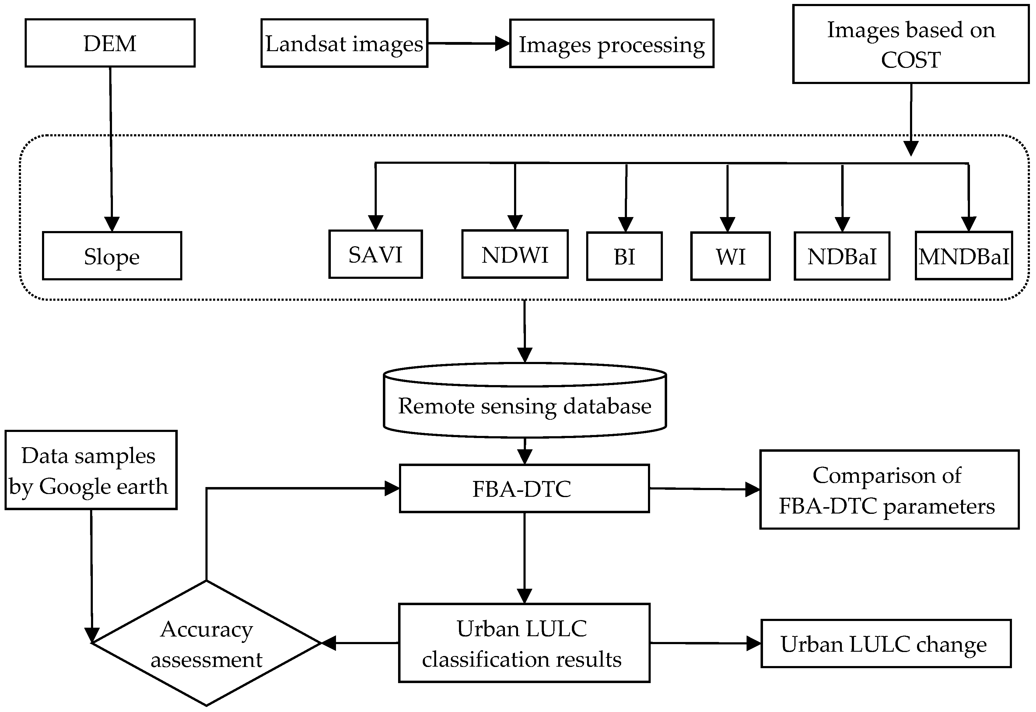
3. Methodology
3.1. Image-Based Atmospheric Correction
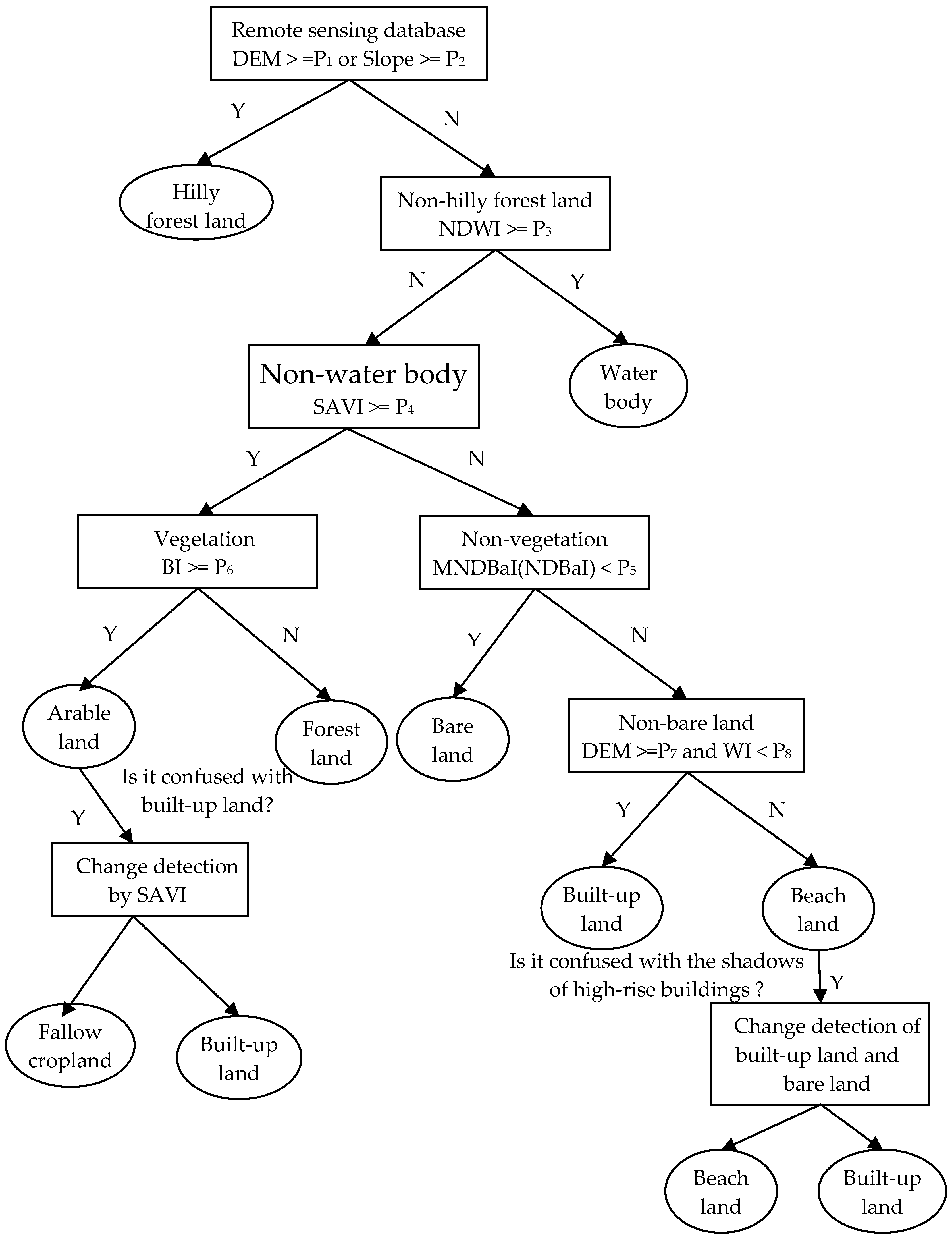
3.2. Decision Tree Classification Approach
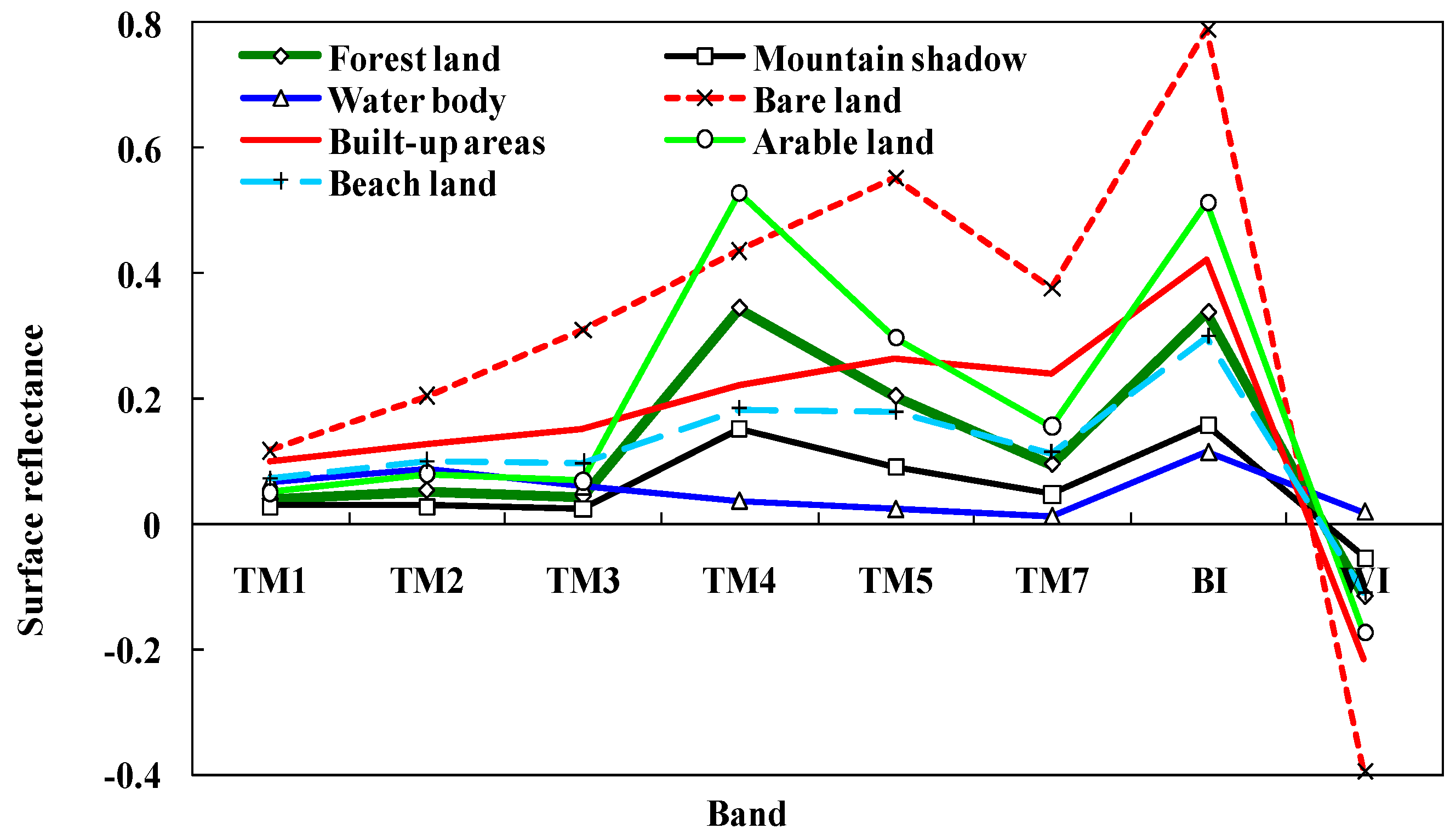
3.2.1. Vegetation Index
3.2.2. Water Index
3.2.3. Bare Land Index
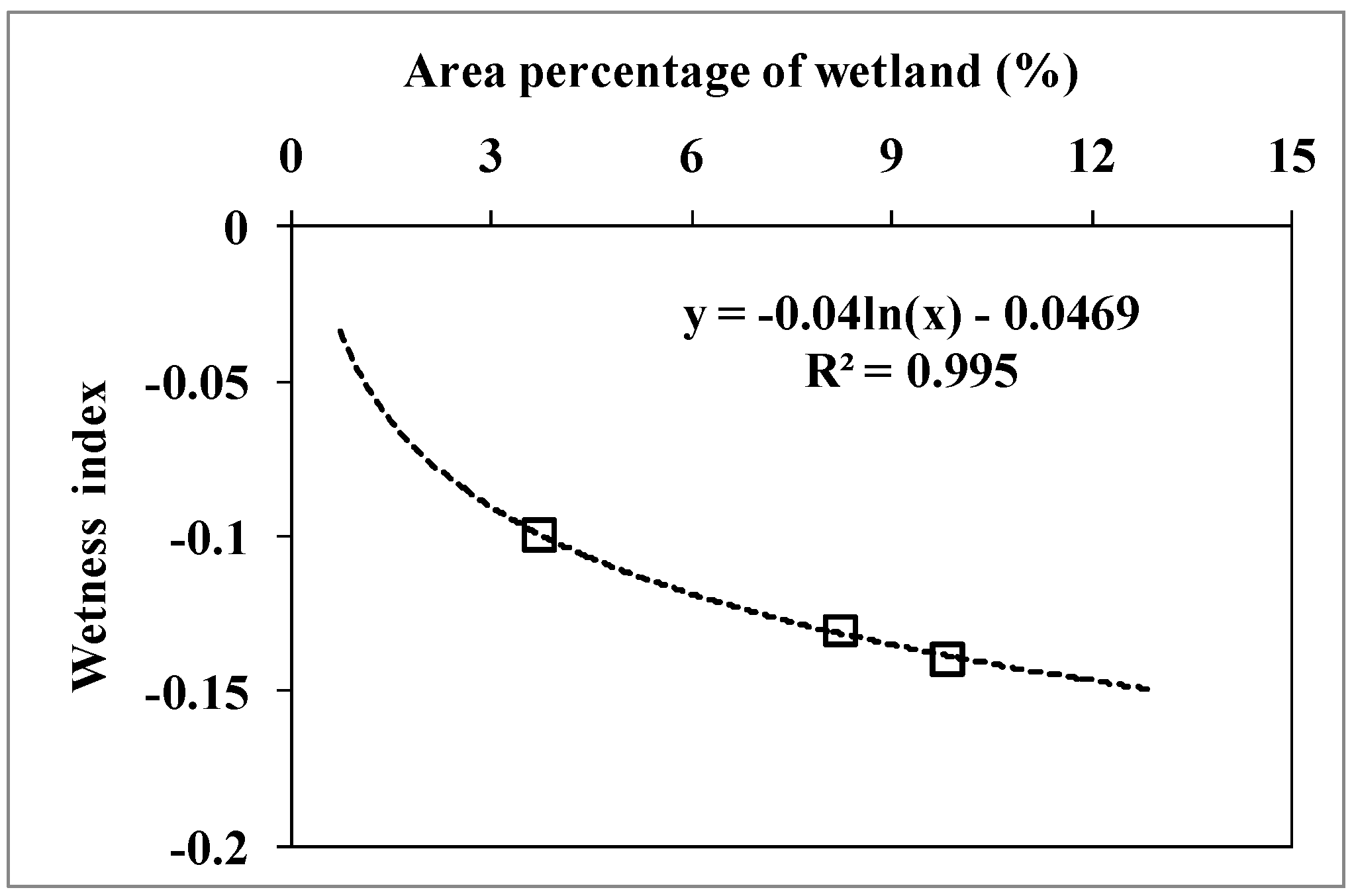
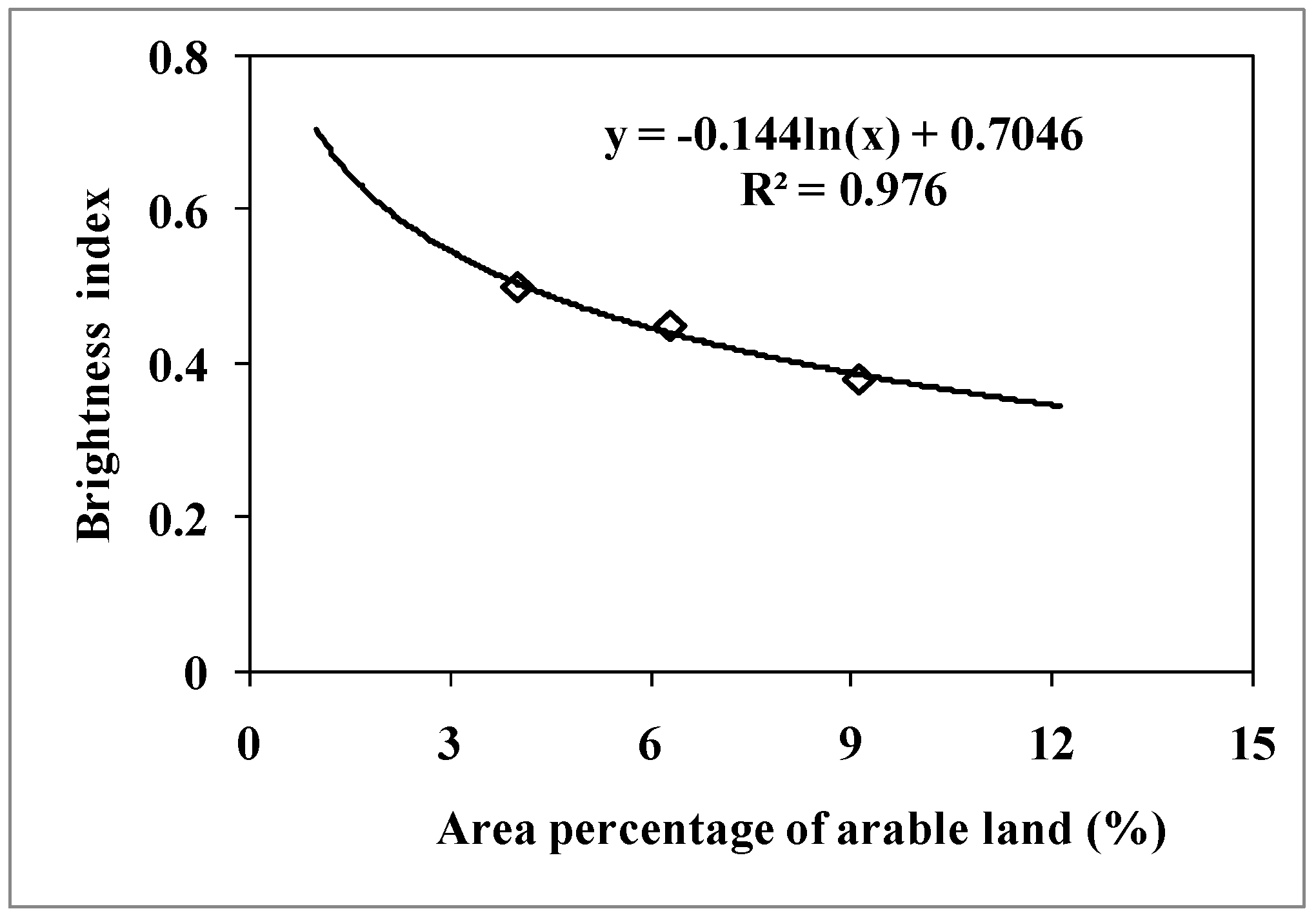
3.2.4. Brightness Index and Wetness Index
3.2.5. FBA-DTC Procedure
3.2.6. Calibration of FBA-DTC Parameters
3.3. Accuracy Assessment
4. Results and Discussion
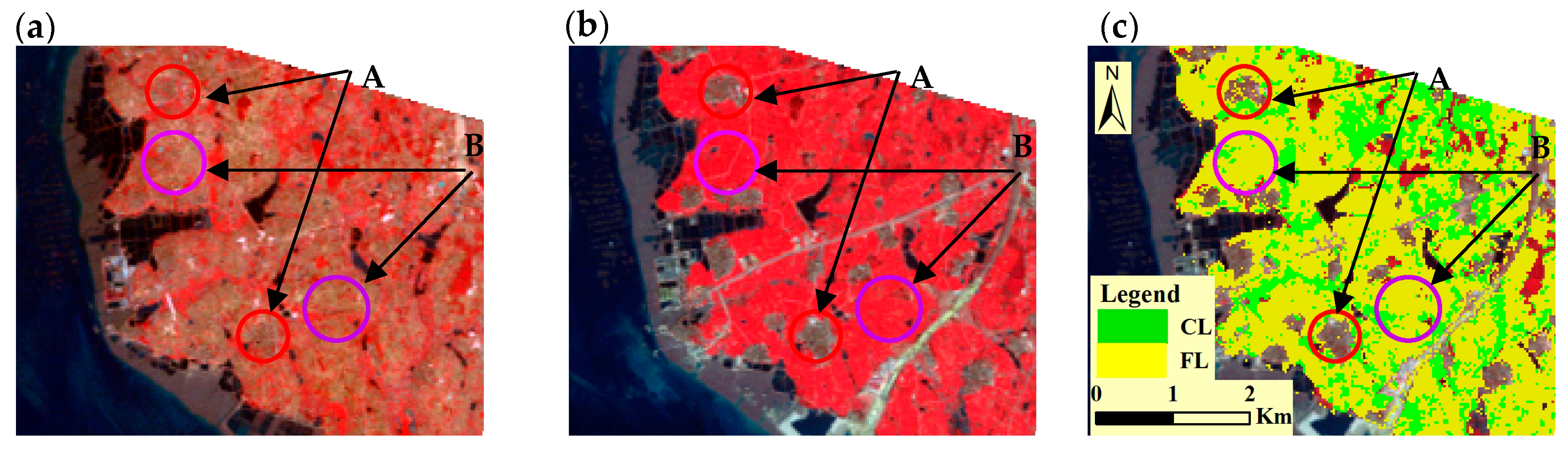
4.1. FBA-DTC Results
4.2. Analysis of Classification Accuracy and Other Similar Studies
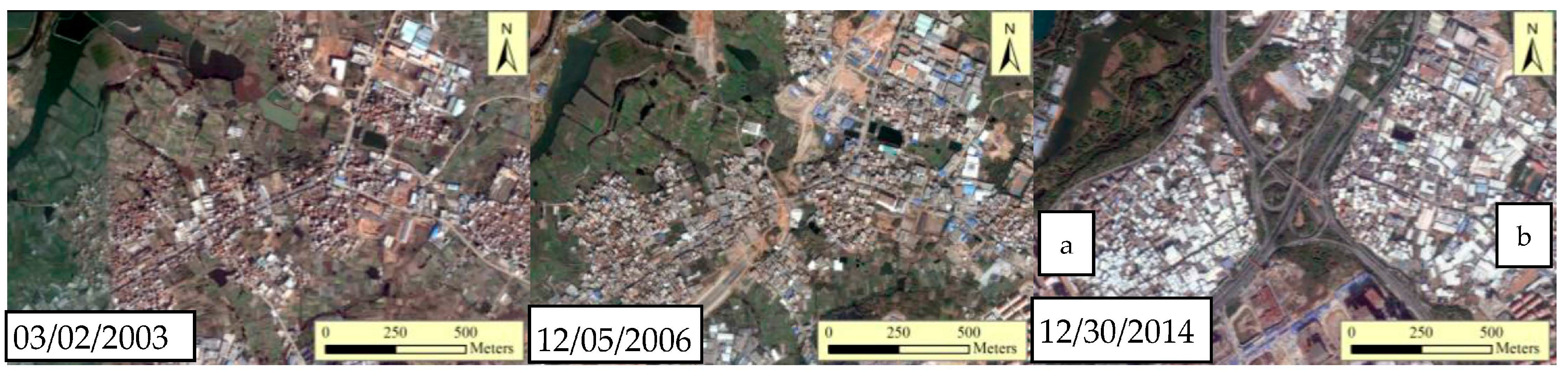
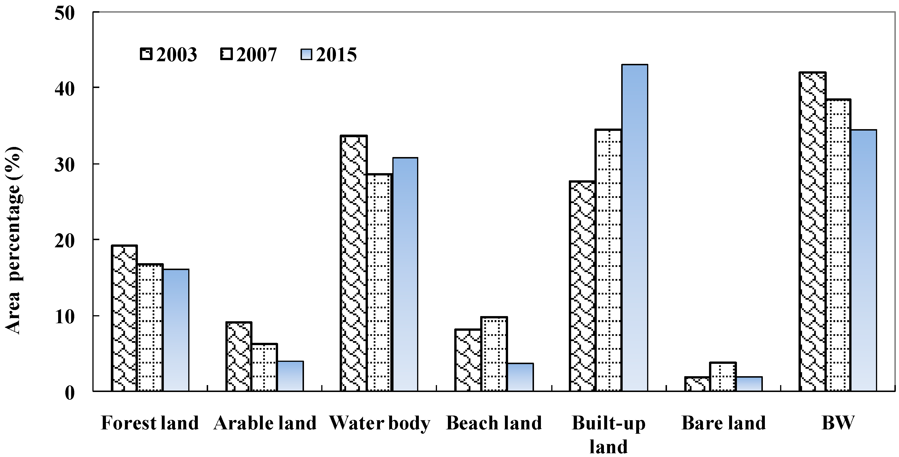
4.3. Spatiotemporal LULC Changes
5. Summary and Conclusions
Acknowledgments
Author Contributions
Conflicts of Interest
References
- Lu, L.L.; Guo, H.D.; Wang, C.Z.; Pesaresi, M.; Ehrlich, D. Monitoring bidecadal development of urban agglomeration with remote sensing images in the Jing-Jin-Tang area, China. J. Appl. Remote Sens. 2014, 8, 084592. [Google Scholar] [CrossRef]
- Grimm, N.B.; Faeth, S.H.; Golubiewski, N.E.; Wu, J.; Bai, X.M.; Briggs, J.M. Global Change and the Ecology of Cities. Science 2008, 319, 756–760. [Google Scholar] [CrossRef] [PubMed]
- Tong, X.H.; Xie, H.; Weng, Q.H. Urban land cover classification with airborne hyperspectral data: What features to use? IEEE J. Sel. Top. Appl. 2014, 7, 3998–4009. [Google Scholar] [CrossRef]
- Hu, T.; Yang, J.; Li, X.; Gong, P. Mapping Urban Land Use by Using Landsat Images and Open Social Data. Remote Sens. 2016, 8, 151. [Google Scholar] [CrossRef]
- Tian, Y.; Yin, K.; Lu, D.; Hua, L.Z.; Zhao, Q.J.; Wen, M.P. Examining Land Use and Land Cover Spatiotemporal Change and Driving Forces in Beijing from 1978 to 2010. Remote Sens. 2014, 6, 10593–10611. [Google Scholar] [CrossRef]
- Elatawneh, A.; Kalaitzidis, C.; Petropoulos, G.P.; Schneider, T. Evaluation of diverse classification approaches for land use/cover mapping in a Mediterranean region utilizing Hyperion data. Int. J. Digit. Earth 2014, 7, 194–216. [Google Scholar] [CrossRef]
- Davranche, A.; Lefebvre, G.; Poulin, B. Wetland monitoring using classification trees and SPOT-5 seasonal time series. Remote Sens. Environ. 2010, 114, 552–562. [Google Scholar] [CrossRef]
- Mathieu, R.; Aryal, J. Object-based classification of Ikonos imagery for mapping large-scale vegetation communities in urban areas. Sensors 2007, 7, 2860–2880. [Google Scholar] [CrossRef] [PubMed]
- Lu, D.; Hetrick, S.; Moran, E. Land cover classification in a complex urban-rural landscape with quickbird imagery. Photogramm. Eng. Remote Sens. 2010, 76, 1159–1168. [Google Scholar] [CrossRef]
- Jawak, S.D.; Luis, A.J. Improved land cover mapping using high resolution multiangle 8-band WorldView-2 satellite remote sensing data. J. Appl. Remote Sens. 2013, 7, 073573. [Google Scholar] [CrossRef]
- Fauvel, M.; Benediktsson, J.A.; Chanussot, J.; Sveinsson, J.R. Spectral and spatial classification of hyperspectral data using SVMs and morphological profiles. IEEE Trans. Geosci. Remote Sens. 2008, 46, 3804–3814. [Google Scholar] [CrossRef]
- Guo, H.; Huang, Q.; Li, X.; Sun, Z.; Zhang, Y. Spatiotemporal analysis of urban environment based on the vegetation–impervious surface–soil model. J. Appl. Remote Sens. 2014, 8, 084597. [Google Scholar] [CrossRef]
- Yuan, H.; Van Der Wiele, C.F.; Khorram, S. An automated artificial neural network system for land use/land cover classification from Landsat TM imagery. Remote Sens. 2009, 1, 243–265. [Google Scholar] [CrossRef]
- Gopal, S.; Tang, X.J.; Phillips, N.; Nomack, M.; Pasquarella, V.; Pitts, J. Characterizing urban landscapes using fuzzy sets. Comput. Environ. Urban Syst. 2016, 57, 212–223. [Google Scholar] [CrossRef]
- Petropoulos, G.P.; Vadrevu, K.P.; Kalaitzidis, C. Spectral angle mapper and object-based classification combined with hyperspectral remote sensing imagery for obtaining land use/cover mapping in a Mediterranean region. Geocarto Int. 2013, 28, 114–129. [Google Scholar] [CrossRef]
- Lo, C.P.; Choi, J. A hybrid approach to urban land use/cover mapping using Landsat 7 Enhanced Thematic Mapper Plus (ETM+) images. Int. J. Remote Sens. 2004, 25, 2687–2700. [Google Scholar] [CrossRef]
- Wentz, E.A.; Nelson, D.; Rahman, A.; Stefanov, W.L.; Roy, S.S. Expert system classification of urban land use/cover for Delhi, India. Int. J. Remote Sens. 2008, 29, 4405–4427. [Google Scholar] [CrossRef]
- Pal, M.; Mather, P.M. An assessment of the effectiveness of decision tree methods for land cover classification. Remote Sens. Environ. 2003, 86, 554–565. [Google Scholar] [CrossRef]
- Wang, C.; Liu, H.Y.; Zhang, Y.; Li, Y.F. Classification of land-cover types in muddy tidal flat wetlands using remote sensing data. J. Appl. Remote Sens. 2013, 7, 073457. [Google Scholar] [CrossRef]
- Punia, M.; Joshi, P.K.; Porwal, M.C. Decision tree classification of land use land cover for Delhi, India using IRS-P6 AWiFS data. Expert Syst. Appl. 2011, 38, 5577–5583. [Google Scholar] [CrossRef]
- Baker, C.; Lawrence, R.; Montagne, C.; Patten, D. Mapping wetlands and riparian areas using Landsat ETM+ imagery and decision-tree-based models. Wetlands 2006, 26, 465–474. [Google Scholar] [CrossRef]
- Otukei, J.R.; Blaschke, T. Land cover change assessment using decision trees, support vector machines and maximum likelihood classification algorithms. Int. J. Appl. Earth Obs. Geoinf. 2010, 12, S27–S31. [Google Scholar] [CrossRef]
- Sesnie, S.E.; Gessler, P.E.; Finegan, B.; Thessler, S. Integrating Landsat TM and SRTM–DEM derived variables with decision trees for habitat classification and change detection in complex neotropical environments. Remote Sens. Environ. 2008, 112, 2145–2159. [Google Scholar] [CrossRef]
- Tooke, T.R.; Coops, N.C.; Goodwin, N.R.; Voogt, J.A. Extracting urban vegetation characteristics using spectral mixture analysis and decision tree classifications. Remote Sens. Environ. 2009, 113, 398–407. [Google Scholar] [CrossRef]
- Kandrika, S.; Roy, P.S. Land use land cover classification of Orissa using multi-temporal IRS-P6 awifs data: A decision tree approach. Int. J. Appl. Earth Obs. Geoinf. 2008, 10, 186–193. [Google Scholar] [CrossRef]
- Qi, Z.; Yeh, A.G.O.; Li, X.; Lin, Z. A novel algorithm for land use and land cover classification using RADARSAT-2 polarimetric SAR data. Remote Sens. Environ. 2012, 118, 21–39. [Google Scholar] [CrossRef]
- Powell, R.L.; Roberts, D.A.; Dennison, P.E.; Hess, L.L. Subpixel mapping of urban land cover using multiple endmember spectral mixture analysis: Manaus, Brazil. Remote Sens. Environ. 2007, 106, 253–267. [Google Scholar] [CrossRef]
- He, C.Y.; Shi, P.J.; Xie, D.Y.; Zhao, Y.Y. Improving the normalized difference built-up index to map urban built-up areas using a semiautomatic segmentation approach. Remote Sens. Lett. 2010, 1, 213–221. [Google Scholar] [CrossRef]
- Khatami, R.; Mountrakis, G.; Stehman, S.V. A meta-analysis of remote sensing research on supervised pixel-based land-cover image classification processes: General guidelines for practitioners and future research. Remote Sens. Environ. 2016, 177, 89–100. [Google Scholar] [CrossRef]
- Lin, T.; Xue, X.; Shi, L.; Gao, L. Urban spatial expansion and its impacts on island ecosystem services and landscape pattern: A case study of the island city of Xiamen, Southeast China. Ocean Coast. Manag. 2013, 81, 90–96. [Google Scholar] [CrossRef]
- Tang, L.N.; Zhao, Y.; Yin, K.; Zhao, J. City profile: Xiamen. Cities 2013, 31, 615–624. [Google Scholar] [CrossRef]
- Hua, L.Z.; Li, X.Q.; Tang, L.N.; Yin, K.; Zhao, Y. Spatio-temporal dynamic analysis of island-city landscape: A case study of Xiamen Island, China. Int. J. Sustain. Dev. World Ecol. 2010, 17, 273–278. [Google Scholar] [CrossRef]
- Hua, L.Z.; Tang, L.N.; Cui, S.H.; Yin, K. Simulating Urban Growth Using the SLEUTH Model in a Coastal Peri-Urban District in China. Sustainability 2014, 6, 3899–3914. [Google Scholar] [CrossRef]
- Hao, P.; Sliuzas, R.; Geertman, S. The development and redevelopment of urban villages in Shenzhen. Habitat Int. 2011, 35, 214–224. [Google Scholar] [CrossRef]
- Chavez, P.S. Image-based atmospheric corrections—Revisited and revised. Photogramm. Eng. Remote Sens. 1996, 62, 1025–1036. [Google Scholar]
- Wu, J.; Wang, D.; Bauer, M.E. Image-based atmospheric correction of QuickBird imagery of Minnesota cropland. Remote Sens. Environ. 2005, 99, 315–325. [Google Scholar] [CrossRef]
- Lu, D.; Mausel, P. Assessment of atmospheric correction methods applicable to Amazon basin LBA research. Int. J. Remote Sens. 2002, 23, 2651–2671. [Google Scholar] [CrossRef]
- Huete, A.R. A Soil-adjusted vegetation index (SAVI). Remote Sens. Environ. 1988, 25, 295–309. [Google Scholar] [CrossRef]
- McFeeters, S.K. The use of the Normalized Difference Water Index (NDWI) in the delineation of open water features. Int. J. Remote Sens. 1996, 17, 1425–1432. [Google Scholar] [CrossRef]
- Zhao, H.M.; Chen, X.L. Use of normalized difference bareness index in quickly mapping bare areas from TM/ETM+. In Proceedings of the 2005 IEEE International Geoscience and Remote Sensing Symposium, Seoul, Korea, 25–29 July 2005; pp. 1666–1668. [Google Scholar]
- Kauth, R.J.; Thomas, G.S. The tasseled cap—A graphic description of the spectral-temporal development of agricultural crops as seen by Landsat. In Proceedings of the Symposium on Machine Processing of Remotely Sensed Data, Purdue University, West Lafayette, IN, USA, 29 June–1 July 1976. [Google Scholar]
- Crist, E.P. A TM tasseled cap equivalent transformation for reflectance factor data. Remote Sens. Environ. 1985, 17, 301–306. [Google Scholar] [CrossRef]
- Baig, M.H.; Zhang, L.; Shuai, T.; Tong, Q. Derivation of a tasselled cap transformation based on Landsat 8 at-satellite reflectance. Remote Sens. Lett. 2014, 5, 423–431. [Google Scholar] [CrossRef]
- Biradar, C.M.; Thenkabail, P.S.; Noojipady, P.; Li, Y.; Dheeravath, V.; Turral, H.; Velpuri, M.; Gumma, M.K.; Gangalakunta, O.R.; Cai, X.L.; et al. A global map of rainfed cropland areas (GMRCA) at the end of last millennium using remote sensing. Int. J. Appl. Earth Obs. Geoinf. 2009, 11, 114–129. [Google Scholar] [CrossRef]
- Hu, Q.; Wu, W.; Xia, T.; Yu, Q.; Yang, P.; Li, Z.; Song, Q. Exploring the use of Google Earth imagery and object-based methods in land use/cover mapping. Remote Sens. 2013, 5, 6026–6042. [Google Scholar] [CrossRef]


| Image Type | Image Acquisition Date | Sun Elevation Angle (Degree) | Path/Row |
|---|---|---|---|
| Landsat 5 TM | 28 October 2003 | 45.5 | 119/43 |
| Landsat 5 TM | 8 January 2007 | 36.7 | 119/43 |
| Landsat 8 OLI | 14 January 2015 | 38.0 | 119/43 |
| Year | DEM (P1) | Slope (P2) | NDWI (P3) | SAVI (P4) | MNDBaI (P5) | MNDBaI (P5) | BI (P6) | DEM (P7) | WI (P8) |
|---|---|---|---|---|---|---|---|---|---|
| 2003 | 112 | 10 | −0.1 | 0.28 | −0.05 | 0.38 | 6 | −0.13 | |
| 2007 | 112 | 10 | −0.1 | 0.31 | 0.33 | 0.45 | 6 | −0.14 | |
| 2015 | 112 | 10 | 0 | 0.31 | 0.39 | 0.50 | 6 | −0.10 |
| Classified | Classified | Reference | Data | ||||||
|---|---|---|---|---|---|---|---|---|---|
| Method | Data | FL | AL | WB | Beach | BUA | BL | Total | UA (%) |
| FBA-DTC | FL | 122 | 1 | 0 | 0 | 7 | 1 | 131 | 93.13 |
| AL | 7 | 58 | 0 | 0 | 3 | 2 | 70 | 82.86 | |
| WB | 0 | 0 | 203 | 1 | 1 | 0 | 205 | 99.02 | |
| Beach | 0 | 0 | 4 | 62 | 2 | 0 | 68 | 91.18 | |
| BUA | 6 | 0 | 2 | 1 | 249 | 8 | 266 | 93.61 | |
| BL | 1 | 3 | 0 | 0 | 3 | 53 | 60 | 88.33 | |
| Total | 136 | 62 | 209 | 64 | 265 | 64 | 800 | ||
| PA (%) | 89.71 | 93.55 | 97.13 | 96.88 | 93.96 | 82.81 | |||
| MLC | FL | 71 | 0 | 0 | 0 | 0 | 0 | 71 | 100.00 |
| AL | 5 | 51 | 0 | 0 | 1 | 1 | 58 | 87.93 | |
| WB | 0 | 0 | 175 | 0 | 0 | 0 | 175 | 100.00 | |
| Beach | 0 | 0 | 0 | 35 | 1 | 0 | 36 | 97.22 | |
| BUA | 59 | 9 | 34 | 29 | 250 | 8 | 389 | 64.27 | |
| BL | 1 | 2 | 0 | 0 | 13 | 55 | 71 | 77.46 | |
| Total | 136 | 62 | 209 | 64 | 265 | 64 | |||
| PA (%) | 52.21 | 82.26 | 83.73 | 54.69 | 94.34 | 85.94 |
| Classified | Classified | Reference | Data | ||||||
|---|---|---|---|---|---|---|---|---|---|
| Method | Data | FL | AL | WB | Beach | BUA | BL | Total | UA (%) |
| FBA-DTC | FL | 131 | 2 | 0 | 0 | 1 | 0 | 134 | 97.76 |
| AL | 8 | 60 | 0 | 0 | 3 | 3 | 74 | 81.08 | |
| WB | 0 | 0 | 202 | 0 | 0 | 0 | 202 | 100.00 | |
| Beach | 0 | 0 | 20 | 73 | 1 | 0 | 94 | 77.66 | |
| BUA | 6 | 2 | 4 | 1 | 215 | 8 | 236 | 91.10 | |
| BL | 1 | 1 | 0 | 0 | 0 | 58 | 60 | 96.67 | |
| Total | 146 | 65 | 226 | 74 | 220 | 69 | 800 | ||
| PA (%) | 89.73 | 92.31 | 89.38 | 98.65 | 97.73 | 84.06 | |||
| MLC | FL | 117 | 7 | 0 | 0 | 1 | 0 | 125 | 93.60 |
| AL | 6 | 55 | 0 | 0 | 2 | 2 | 65 | 84.62 | |
| WB | 0 | 0 | 196 | 5 | 0 | 0 | 201 | 97.51 | |
| Beach | 0 | 0 | 5 | 62 | 0 | 0 | 67 | 92.54 | |
| BUA | 22 | 2 | 24 | 7 | 212 | 14 | 281 | 75.44 | |
| BL | 1 | 1 | 1 | 0 | 5 | 53 | 61 | 86.89 | |
| Total | 146 | 65 | 226 | 74 | 220 | 69 | 800 | ||
| PA (%) | 80.14 | 84.62 | 86.73 | 83.78 | 96.36 | 76.81 |
| Classified | Classified | Reference | Data | ||||||
|---|---|---|---|---|---|---|---|---|---|
| Method | Data | FL | AL | WB | Beach | BUA | BL | Total | UA (%) |
| FBA-DTC | FL | 133 | 4 | 0 | 0 | 7 | 2 | 146 | 91.10 |
| AL | 10 | 73 | 2 | 0 | 6 | 5 | 96 | 76.04 | |
| WB | 0 | 0 | 217 | 2 | 0 | 0 | 219 | 99.09 | |
| Beach | 0 | 0 | 15 | 75 | 1 | 0 | 91 | 82.42 | |
| BUA | 7 | 2 | 4 | 0 | 168 | 7 | 188 | 89.36 | |
| BL | 0 | 0 | 0 | 0 | 1 | 59 | 60 | 98.33 | |
| Total | 150 | 79 | 238 | 77 | 183 | 73 | 800 | ||
| PA (%) | 88.67 | 92.41 | 91.18 | 97.40 | 91.80 | 80.82 | |||
| MLC | FL | 85 | 0 | 12 | 8 | 0 | 0 | 105 | 80.95 |
| AL | 56 | 76 | 4 | 0 | 14 | 7 | 157 | 48.41 | |
| WB | 1 | 0 | 191 | 0 | 0 | 0 | 192 | 99.48 | |
| Beach | 0 | 0 | 21 | 66 | 0 | 0 | 87 | 75.86 | |
| BUA | 4 | 1 | 10 | 3 | 157 | 6 | 181 | 86.74 | |
| BL | 4 | 2 | 0 | 0 | 12 | 60 | 78 | 76.92 | |
| Total | 150 | 79 | 238 | 77 | 183 | 73 | 800 | ||
| PA (%) | 56.67 | 96.20 | 80.25 | 85.71 | 85.79 | 82.19 |
| Authors | Data Types | Methods | LULC Classes | OA (%) | KC | Increased OA (%) | Increased KC |
|---|---|---|---|---|---|---|---|
| Pal and Mather [18] | Landsat 7 ETM+ | Boosted DTC | 7 | 88.46 | 0.87 | 5.56 | 0.07 |
| MLC | 7 | 82.90 | 0.80 | ||||
| Kandrika and Roy [25] | IRS-P6 AWiFS | DTC (See-5) | 16 | 87.50 | 0.87 | ||
| Punia et al. [20] | IRS-P6 AWiFS | DTC (See-5) | 11 | 91.81 | |||
| Qi et al. [26] | PolSAR | DTC-OOC | 7 | 86.64 | 0.84 | 16.98 | 0.19 |
| MLC | 7 | 69.66 | 0.65 | ||||
| Wang et al. [19] | Landsat | DTC | 7 | 95.87 | - | 4.44 | - |
| 5 TM | MLC | 7 | 91.43 | - | |||
| Hua et al. (this paper) | Landsat | FBA-DTC | 6 | 90.63 | 0.88 | 11.25 | 0.14 |
| 5 TM/2003 | MLC | 6 | 79.38 | 0.74 | |||
| Landsat | FBA-DTC | 92.38 | 0.90 | 5.50 | 0.07 | ||
| 5 TM/2007 | MLC | 6 | 86.88 | 0.83 | |||
| Landsat 8 | FBA-DTC | 93.38 | 0.92 | 13.75 | 0.19 | ||
| OLI/2015 | MLC | 79.63 | 0.73 |
© 2017 by the authors. Licensee MDPI, Basel, Switzerland. This article is an open access article distributed under the terms and conditions of the Creative Commons Attribution (CC BY) license (http://creativecommons.org/licenses/by/4.0/).
Share and Cite
Hua, L.; Zhang, X.; Chen, X.; Yin, K.; Tang, L. A Feature-Based Approach of Decision Tree Classification to Map Time Series Urban Land Use and Land Cover with Landsat 5 TM and Landsat 8 OLI in a Coastal City, China. ISPRS Int. J. Geo-Inf. 2017, 6, 331. https://doi.org/10.3390/ijgi6110331
Hua L, Zhang X, Chen X, Yin K, Tang L. A Feature-Based Approach of Decision Tree Classification to Map Time Series Urban Land Use and Land Cover with Landsat 5 TM and Landsat 8 OLI in a Coastal City, China. ISPRS International Journal of Geo-Information. 2017; 6(11):331. https://doi.org/10.3390/ijgi6110331
Chicago/Turabian StyleHua, Lizhong, Xinxin Zhang, Xi Chen, Kai Yin, and Lina Tang. 2017. "A Feature-Based Approach of Decision Tree Classification to Map Time Series Urban Land Use and Land Cover with Landsat 5 TM and Landsat 8 OLI in a Coastal City, China" ISPRS International Journal of Geo-Information 6, no. 11: 331. https://doi.org/10.3390/ijgi6110331
APA StyleHua, L., Zhang, X., Chen, X., Yin, K., & Tang, L. (2017). A Feature-Based Approach of Decision Tree Classification to Map Time Series Urban Land Use and Land Cover with Landsat 5 TM and Landsat 8 OLI in a Coastal City, China. ISPRS International Journal of Geo-Information, 6(11), 331. https://doi.org/10.3390/ijgi6110331