On Metrics for Location-Aware Games


Abstract
1. Introduction
- In Section 3, we analyze and compare the spatio-temporal support in data handling and metric analysis for different existing commercial and academic game analytics platforms and tools, and their application to location-aware games. The comparative analysis evaluates whether such platforms offer the required features for collecting, processing and visualizing spatio-temporal data. Next, we discuss current limitations of these platforms and tools to set the basis for defining an analytics platform for location-aware games.
- In Section 4, we propose a classification of spatially-related metrics, framed in the realm of other non-spatial metric categorizations from the literature. Our intent is to establish the desired spatial capabilities, which would allow game developers to perform analysis that could otherwise not be done with non-spatial game analytics.
2. Definitions and Terminology
2.1. Gameplay
2.2. Location-Based Games, Location-Aware Games and Geo-Games
2.3. Metrics in Location-Aware Games
3. Geospatial Support in Current Games Analytics Platforms and Tools
3.1. Background for Tool Comparison
3.2. Comparative Analysis
- Data collection. Strategies for data collection can be either time-based or event-based [38]. The differentiation between the two is mainly determined by the fact that data associated with the former strategy is produced at high rates or does not exhibit high variabilities over short periods of time, while on the contrary, data required for event triggering is usually collected and produced “eventually”, based on a certain frequency or as a result of an action in the game. The latter is therefore more meaningful to game developers in the context of the game. An example of time-based data collection is capturing user location at a certain frequency, while an example of event-based data collection is the usage of a given weapon, which can only be collected in case the player changes and selects the particular weapon. Game analytics platforms usually do not distinguish between time- and event-based data collection, which is considered a responsibility of the game developer; they only provide facilities for defining event types and communicating captured data (see further on), independent of their data collection strategy. Indeed, all reviewed game analytical tools follow this approach. We thus do not include data collection strategies in Table 3. Nevertheless, the way data is collected may influence how it can be processed, and therefore influence the choice of analytical methods. We visit this later on in Section 3.3.Another way of qualifying data collection is based on who, rather than how. Drachen and Schubert [39] categorize collected data into player-derived data and system-derived data. Player-derived data refers to data that, at least partly, captures (some) player behavior. Four dimensions are hereby considered relevant: who, what, when and where. Examples of player-derived data include players’ items owned, position, trajectories, etc. We go into more detail on the spatial dimensions of player-derived data when discussing the data representation functional area further on in this section. System-derived data refers to data generated by the game, and is useful for e.g., monitoring technical issues (e.g., network balancing, bug tracking) or the game as a whole. Game analytics engines do not distinguish between player- and system-derived data; it is the responsibility of the game developer to define appropriate event types and communicate the relevant data to track.
- Data communication. It indicates how gathered data is imported or fed into the analytical tool. As mentioned earlier, most of the surveyed tools follow a common architectural pattern: a client part collects data, and a server part performs analytical tasks and provides services for getting the collected data and store it permanently into repositories. Mechanisms for data communication, i.e, how gathered data is transferred from the client to server, can be roughly classified in two groups: data streaming or data upload. In case of data streaming, events are immediately streamed to the server, as real-time reflection of events in the game is important (e.g., real-time game strategy) and overall system performance is not relatively affected by the frequency of data transmission. It has the advantage of enabling on-the-fly analysis over the streamed data.On the other hand, in the data upload group, bits of data are gathered over a certain (usually short) period of time, packaged together, and sent to the server. It is useful in cases where events occur at high rates and/or involve large amounts of data, and therefore immediate and frequent unitary communication might disrupt system performance. On the downside, the lack of live streamed data limits the possibility for real-time data analysis. Indeed, this approach mainly serves analysis a posteriori, and often includes the use of log files (or databases), and batch bulk updates to a server platform for non-real-time analysis. The main reason for using this strategy for data communication is that the amount of data produced could lead to undesirable levels of network load or decreased performance.
- Client-side development support. Supporting tools for game development facilitate the integration of data communication protocols in game clients. This is essential to free game developers from knowing the particularities of the ways to transfer collected data to the analytics back-end platform. Commercial tools mostly provide software development kits (SDKs) for target mobile operating systems (e.g., iOs, Windows, Android) and game engines (e.g., Unity, GameMaker Studio, etc.). REST Application Programming Interfaces (APIs) are another way to support game development, which are supported in varied programming languages (e.g., JavaScript, C#, Java). In general, SDKs and REST APIs are often viewed as secondary features but are extremely useful to make developers’ life easier for, e.g., being in compliance with the protocol to validating and submitting collected data.
- Default event types. Most surveyed platforms include the definitions of events as logical data structures (data models), called event types. Some of them provide default event types, of which each has an associated data model and often, but not necessarily, related processing methods and/or predefined metrics. For example, GameAnalytics [43] provides a “business” event type that is used to track (and validate) real-money transactions in games. Based on this business event type, GameAnalytics supports various types of revenue metrics, such as average daily revenue per daily active user or per paying user.It is worth noting that the way game analytics platforms offer event types influences their extensibility and customizability. The most common logical data model for event types are records, with a fixed number of fields that represent the monitored phenomenon. Record-based event types are useful in many cases, where the data model is relatively static, and a number of event types are predefined for being used in previously known metrics. Another commonly used logical data model is based on arrays of key-value pairs (e.g., DataCracker [34]), which are more versatile and customizable data models than those based on data records mentioned above. From the surveyed game analytics platforms, [40,42,43,44] provide record-based; [34,41,46,47] provide key-value pairs (We consider structured documents like XML (as in the case of [41]), or even unspecified structures that are dynamic (in commercial systems sometimes it is not documented), to be similar to arrays of key-value pairs for the purpose of this comparison). like event types; and [45] provides a combination of both.
- Custom event types. Contrary to default event types, custom event types allow game developers to define their own data model to handle any type of monitored aspect of the game. Custom event types provide high-level support for game-specific events, and the (composite) data they require. This feature is linked to the definition of custom metrics (see the third functional area below), as the combination of both gives game developers the freedom to extend the capabilities of a game analytics platform to practically monitor and compute any facet of a game. The support for this feature is varied among the analysed platforms, although most of them restrict the creation of new data models to those based exclusively on simple data types (i.e., boolean, string, integer). Support for more complex and nested data structures was practically inexistent. Reasons might be the absence of a flexible processing model and/or rigid storage schemes to handle data structures beyond that of a sequence of simple data types.
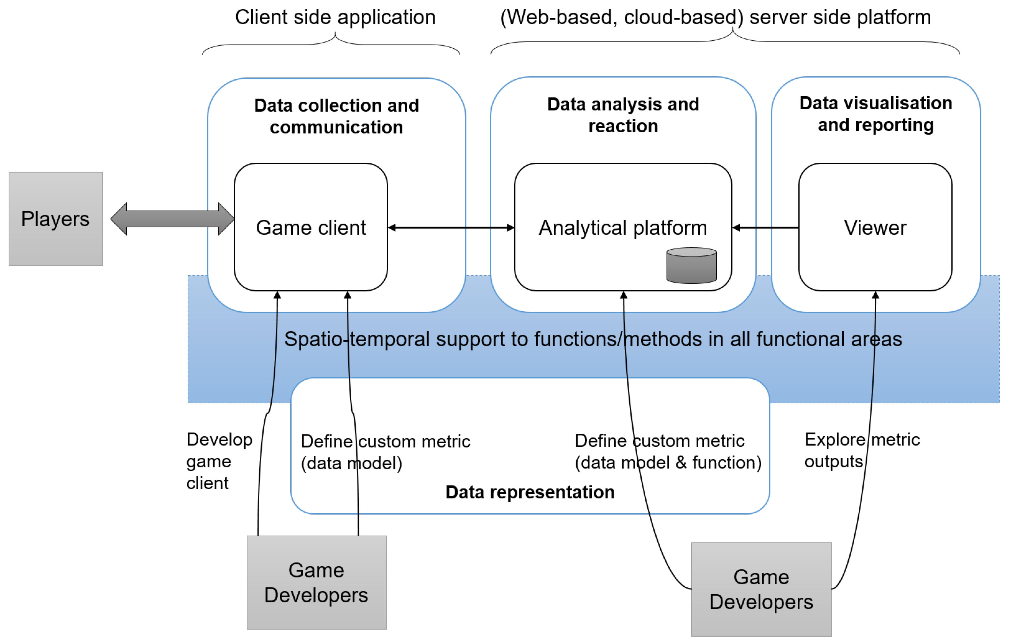
- Geospatial data support. As mentioned earlier, Drachen and Schubert [39] categorised collected data for game analytics into player-derived data and system-derived data. From the four dimensions for player-derived data (who, what, where, when), two are particularly relevant from the spatio-temporal point of view: “where is this happening?” and “when (at what time) is that happening?”, where this/that is any relevant (player-specific) event in the game. For the former (where), the authors pointed to “the spatial position, user location, movement, speed, orientation”. In case of games where no avatars exist, location may refer to the screen coordinates when users touch or swipe on the gaming device. The latter (when) looks for a temporal reference, which may refer to actual or in-game time, point in time, time interval, timespan, etc. As space and time are so tightly integrated in games, custom data models for event types should ideally be able to natively manage and store data structures to support the aforementioned spatio-temporal characteristics.That is why, specifically for the purpose of this paper on the study of geospatial metrics for location-aware games, we envision the support for geospatial data as a cross-cutting layer (see Figure 1), i.e., where spatio-temporal and/or spatial characteristics of collected data are supported, either by default or by custom event types. In practice, though, native support is scarce, and game developers are mostly limited to create simple representation of space: pairs of coordinates. To do so, we found two approaches in between the tools that provide some support for capturing geo-spatial data. A first group of tools ([34,40,41,42,47] is able to capture coordinates as a pair of simple attributes (location/space attributes), which is obviously quite far from being able to really handle geospatial data. A second group ([43,45,46] does not provide explicit support, but is possible to store the coordinates by mean of other mechanisms, usually custom attributes. In these cases it is up to the developer to implement the best way to store spatio-temporal information.
- Default metrics and games analysis. All game analytic platforms support a set of predefined metrics, algorithms and analysis tools that are available to process collected data. Predefined metrics are re-usable and possibly customizable metrics that address commonly measurable game aspects and are to be used out of the box. Most (commercial) platforms focus on monetary aspects (e.g., virtual money spent per session, amount of purchases), yet some also offer other default metrics (e.g., related to user engagement, mean time spent by a user in the game per day, social aspects such as invites and shares, or interaction with interface elements). Next to default metrics, all platforms also provide algorithms and analysis tools that can be used to analyze captured data, and/or to build more complex (custom) metrics with (see next bullet). For example, descriptive statistical methods are commonly offered (measures of central tendency, e.g., average, median; measures of variability, e.g., standard deviation, etc.); as they are common, we do not shown these in Table 5. Further algorithms and analysis tools include funnels (i.e., a series of steps towards a certain goal, a kind of behavior analysis), predictive analysis, events correlation, frequency analysis, segments analysis (The user base can be segmented to target the analysis on such segments, or make metrics comparison between different segments (i.e., paid users, and trial users)), A-B test (A method for comparing two versions of the game, to determine which one performs better regarding some criteria), OLAP Cubes A technique for analyzing multi-dimensional data), and Funnels (A technique for describing the navigation path followed by users in a system). Note that visual analytics are considered within the next functional area (Table 7).
- Custom metrics. Custom metrics allow developers to capture game-specific analytics, or extend already available metrics. A custom metric is hereby understood as a custom-defined distance function with an arbitrary level of complexity. Developers have a certain specification mechanism to their disposal (e.g., a restricted programming language), as well as the default game analytics tools and methods (see previous bullet) available to define their custom metric, and may extend default or other custom metrics. It is similar to coding user functions in any programming language. Custom metrics may be using input data captured as default event types, yet often they are based on custom event types as the underlying data model, required to model or structure a particular phenomenon. As such, the definition of custom metrics is linked to the ability to define custom event types. The possibility to specify new event types and custom metrics, beyond of default ones, is obviously a desirable characteristic for an analytics platform.
- Spatial analysis. As mentioned when discussing custom event types, we consider geospatial data support, and spatial analysis support as cross-cutting layers. With respect to metrics, this refers to regular metrics supporting geospatial data types, and specific spatial analytical technique or method supported or integrated in the analytics platform. As Table 5 shows, native support for spatial analysis is practically inexistent.
- Reactive rules. When certain logical conditions are met over the results of data analysis, more specifically metric outputs, the system has the ability to react by triggering purposeful actions. Typical actions with a specific aim are data storage (where possibly only a subset of the outputs is stored; supported by all surveyed platforms and thus not mentioned in Table 6) or notifications (e.g., to game developers or players). Further actions are often required to realize detailed, in-game consequences of observed behavior, for example to perform additional data transformation over the outputs of the metric or to trigger additional analytical tasks in cascade. In such a case, the ability for a game developer to program custom reactive actions is essential to optimize the game, and possibly trigger game mechanics updates. Obviously, actual alterations to the game are within the real of the game implementation, not the analytics platforms. If a platform supports some form of reactive rules (i.e., logical conditions and consequent actions), we specify the type of action (storage, notification, or custom) in Table 6.
- Geospatial support. Output data from metrics may contain geospatial data structures, such as trajectories or polygons (e.g., representing the geographical area covered by a player). Such geospatial data may be subject to meet certain spatial or spatio-temporal conditions (e.g., within, intersect, crosses) to check, for example, whether a player’s traveled distance during a game session is greater than 1 km, or the percentage of time a player remained inside a delimited area (often called “fence”) is above average. Similarly, triggered actions can also be spatially-enabled. For example, actions that redistribute monitoring points or recalculate (a metric’s) geofencing areas. For convenience, we split this feature into two columns in Table 6: geospatial support for conditions and actions, respectively.
- Data access. Open access to data is useful to allow users to get access and query observed data, metrics results, or both, for further analysis by third-party tools. While this allows to harness the (extended) analytical power of external tool, in case the capabilities of the game analytics platform prove to be too general and/or insufficient, it also hinders integrability for real-time analysis and reactive rules generation. Indeed, access to analytical/output data is usually done for later off-line analysis. We broadly contemplate two strategies for data access: the first is based on on-line interfaces for querying analytical data (e.g., service end-points), and the other to enable a full export or bulk download.
- Visual analytics. It differs from games analysis in that the latter is thought to be part of metric computation to process collected/observed data. Visual analytical tools are situated at the end of the analytical pipeline (Figure 1), taking metric outputs as input (possibly after data transformations) to carry out in-depth analysis. Visual analytics comprises a large and varied arsenal of data visualisation and inspection techniques [48,49], in order to gain new insights and discover new patterns for game developers, which would otherwise be difficult to detect and/or go unnoticed. Most of the surveyed tools and platforms only support basic techniques, such as different types of charts to visually summarise and aggregate data.
- Geospatial support. Similar to the geospatial support for game analysis presented earlier, here we refer to specific spatial and spatio-temporal support for visual analytics, commonly referred to in literature as visual geoanalytics [50]. Examples include visualization for moving point datasets (e.g., players position in multiplayer games) or time series (e.g., virtual land owernership or visibilitity over time). This area of research is quite extensive and developed methods and techniques have been proven to be effective for decision making [51]. Only a few analytical tools and platforms (e.g., [42]) offer basic support, in the form of map visualisation of simple data types like points or heatmaps (density maps of spatial frequency).
3.3. Limitations
4. Classification of Metrics for Location-Aware Games
- to make spatial metrics visible by placing them at the same level and embedding them within the larger context of metrics for games. Higher visibility may lead to the next generation of analytics platforms natively supporting spatial data and spatially-related metrics, increasingly recognising the strategic importance of managing location and spatial concepts in games.
- to bring the gaming and GIScience research communities’ attention to location-aware games as an interesting and relatively unexplored research field, with ample possibility for additional research and practical tool development that may directly impact applications in a wide variety of application fields, such as (smart) cities (e.g., urban games), health (e.g., games to stimulate physical activity) or sociology (e.g., games to stimulate social inclusion).
4.1. Existing Metrics Classifications
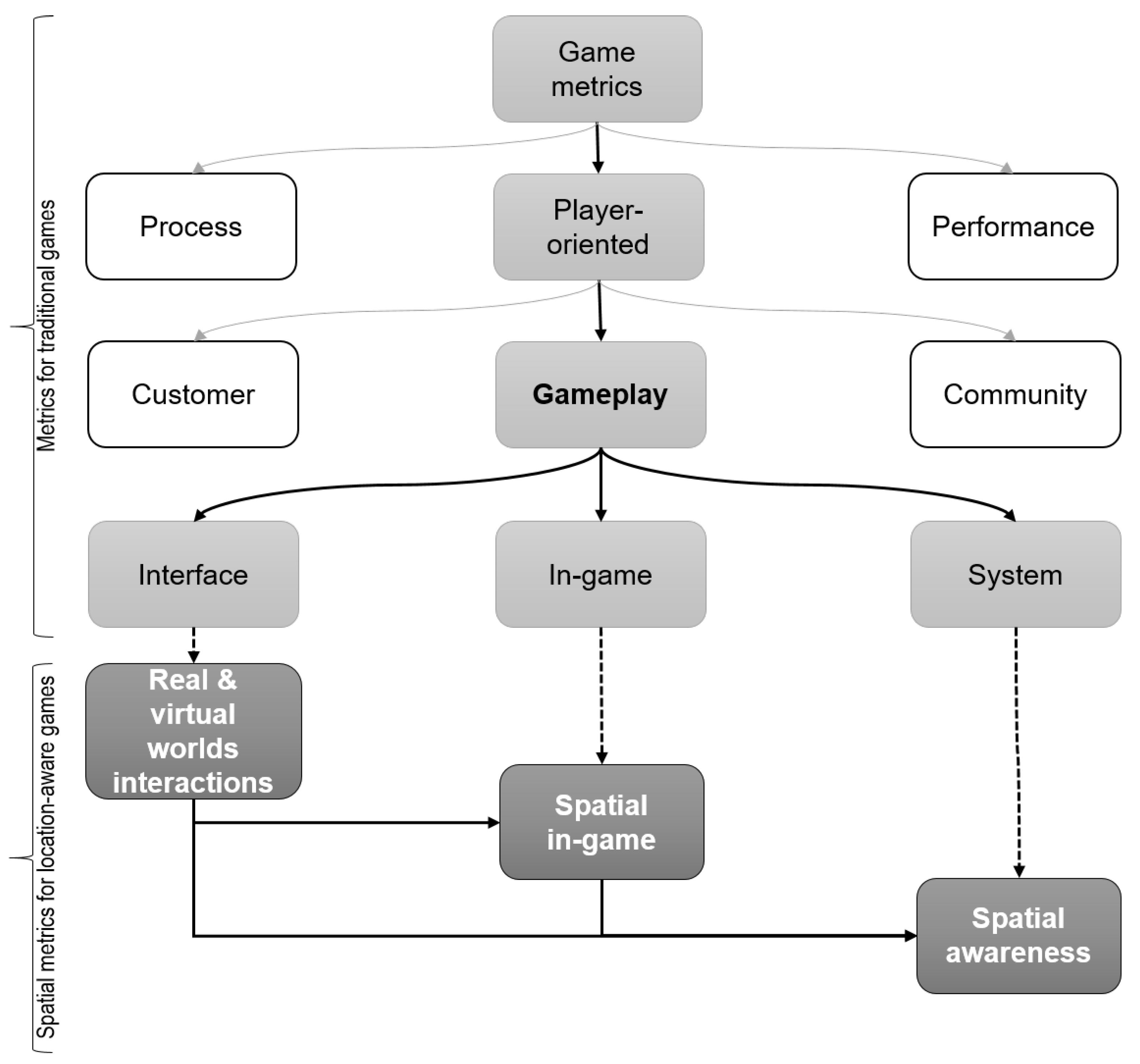
4.2. Spatial Metrics Classification
4.3. Spatial Metrics
- Location-based metrics (point-based metrics). This category includes metrics that take into account specific locations (i.e., most often represented by coordinates), for example, the location of a player or resource. Point-based metrics are the simplest, yet they may reveal interesting properties of the player, interface and game as a whole. For example, point-based metrics may determine stationary behavior (e.g., an "ambush" in a shooter-based game); proximity or line of sight among and between players, resources, and environmental features; and altitude difference or altitude-related computations. Point-based metrics may reveal relevant game properties, such as significant locations (e.g., locations that attract players) or imbalances (e.g., locations which provide an (unfair) advantage or disadvantage). Example papers supporting this type of metrics include Coulton et al. [29], where location-based metrics are employed to analyze players behavior in concrete location-based games. In particular, the distance between players as they moved around the game area, and also the mean distance from the average position, is used as a measure of “how adventurous each player was during the game”. Some other examples are presented in [57], in that location is used for analyzing where deaths occur in the game, or where the users request help, for determining those places where possible imbalances might be present. In [32] the speed is used for determining spots in the game where the player was less challenged.
- Trajectory metrics. This category includes metrics that take the trajectory of the players (or resources) into consideration, for example, the distance between the trajectories of two players; the time spent in a trajectory; rhumb; the convergence or divergence of trajectories; trajectory patterns; etc. can be candidates for metrics, or elements to consider in metrics. Example papers supporting this type of metric include Hoobler et al. [58], where the player trajectory analysis can provide information about the players or team strategies, as well as resources (e.g., trajectories of fires/shots). In [39] the importance of trajectory analysis is highlighted in order to detect bots, analyzing different types of user behaviors (cooperation, flock etc), and detection of user strategies that can be indicators of game imbalance problems. Coulton et al. [29] also used trajectories as a basis for analysis of players behavior (and unusual behaviors) during the game.
- Space-related metrics (area-related metrics). This category includes metrics which perform calculations based on areas, for example, in the centre, forest, sea; overlapping/disjoint/contained areas (e.g., action radius); inclusion/exclusion of a player/resource in an area (i.e., geofencing); explored/covered area; exploration speed; area exploitation; spreadness/distribution of resources (i.e., rewards); and so on. Example papers supporting this type of metrics include Hoobler et al. [58], who suggested clustering techniques for evaluating the distribution of game resources or for design validation (“planned for affordance”). This is especially important for location-aware games, where access to resources usually involves a physical effort. In [59] clustering techniques are used for identifying areas where the users behave more fiercely in the game. Similarly, Wallner and Kriglstein [60] used clustering techniques for providing insights about the distribution of changes in states of the game. In [32] the analysis is based on comparing player’s behavior in selected areas of the game. Finally, geofencing techniques are exemplified by Map Attack ESRI [61], while Martí et al. [62] discussed its application for noise pollution monitoring.
5. Discussion
5.1. Spatial Metrics to Improve Gameplay in Location-Aware Games
5.2. Implication for Future Geospatial Game Analytics Platforms
6. Conclusions and Future Work
Acknowledgments
Author Contributions
Conflicts of Interest
References
- Avedon, E.M.; Sutton-Smith, B. The Study of Games; John Wiley: New York, NY, USA, 1971. [Google Scholar]
- Salen, K.; Zimmerman, E. Rules of Play; Game Design Fundamentals; MIT Press: Cambridge, MA, USA, 2004. [Google Scholar]
- Ritterfeld, U.; Cody, M.; Vorderer, P. Serious Games: Mechanisms and Effects; Routledge: Abingdon, UK, 2009. [Google Scholar]
- Johnson, D.; Horton, E.; Mulcahy, R.; Foth, M. Gamification and serious games within the domain of domestic energy consumption: A systematic review. Renew. Sustain. Energy Rev. 2017, 73, 249–264. [Google Scholar] [CrossRef]
- Pedreira, O.; García, F.; Brisaboa, N.; Piattini, M. Gamification in software engineering—A systematic mapping. Inf. Softw. Technol. 2015, 57, 157–168. [Google Scholar] [CrossRef]
- Duggan, E. Squaring the (Magic) Circle: A Brief Definition and History of Pervasive Games. In Playable Cities: The City as a Digital Playground; Nijholt, A., Ed.; Springer: Singapore, 2017; pp. 111–135. [Google Scholar]
- Schlatter, B.E.; Hurd, A.R. Geocaching: 21st-century hide-and-seek. J. Phys. Educ. Recreat. Dance 2005, 76, 28–32. [Google Scholar] [CrossRef]
- Smith, C. 80 Amazing Pokemon Go Statistics and Facts (September 2017). Available online: https://expandedramblings.com/index.php/pokemon-go-statistics/ (accessed on 26 September 2017).
- Schlieder, C.; Kiefer, P.; Matyas, S. Geogames: Designing location-based games from classic board games. IEEE Intell. Syst. 2006, 21, 40–46. [Google Scholar] [CrossRef]
- Schlieder, C.; Kiefer, P.; Matyas, S. Geogames: A conceptual framework and tool for the design of location-based games from classic board games. In Proceedings of the International Conference on Intelligent Technologies for Interactive Entertainment, Madonna di Campiglio, Italy, 30 November–2 December 2005; Springer: Berlin, Germany; pp. 164–173. [Google Scholar]
- González Sánchez, J.L.; Padilla Zea, N.; Gutiérrez, F.L. From Usability to Playability: Introduction to Player-Centred Video Game Development Process. In Proceedings of the 1st International Conference on Human Centered Design, San Diego, CA, USA, 19–24 July 2009; Springer: Berlin, Germany; pp. 65–74. [Google Scholar]
- Jaffe, A.; Miller, A.; Andersen, E.; Liu, Y.E.; Karlin, A.; Popovic, Z. Evaluating Competitive Game Balance with Restricted Play. In Proceedings of the Eighth AAAI Conference on Artificial Intelligence and Interactive Digital Entertainment, Stanford, CA, USA, 8–12 October 2012; pp. 26–31. [Google Scholar]
- Kiefer, P.; Matyas, S. The Geogames Tool: Balancing spatio-temporal design parameters in location-based games. In Proceedings of the 7th International Conference on Computer Games, Angoulême, France, 28–30 November 2005; pp. 216–222. [Google Scholar]
- Reis, J.P.; Silva, E.A.; Pinho, P. Spatial metrics to study urban patterns in growing and shrinking cities. Urban Geogr. 2016, 37, 246–271. [Google Scholar] [CrossRef]
- García, F.; Pedreira, O.; Piattini, M.; Cerdeira-Pena, A.; Penabad, M. A Framework for Gamification in Software Engineering. J. Syst. Softw. 2017, 132, 21–40. [Google Scholar] [CrossRef]
- Bhatti, S.S.; Reis, J.P.; Silva, E.A. Spatial Metrics: The Static and Dynamic Perspectives. In Reference Module in Earth Systems and Environmental Sciences; Elsevier: Amsterdam, The Netherlands, 2017. [Google Scholar]
- Seaborn, K.; Fels, D.I. Gamification in theory and action: A survey. Int. J. Hum.-Comput. Stud. 2015, 74, 14–31. [Google Scholar] [CrossRef]
- Nacke, L.E.; Deterding, S. The maturing of gamification research. Comput. Hum. Behav. 2017, 71, 450–454. [Google Scholar] [CrossRef]
- El-Nasr, M.S.; Drachen, A.; Canossa, A. Game Analytics: Maximizing the Value of Player Data; Springer: London, UK, 2013. [Google Scholar]
- Drachen, A.; Schubert, M. Spatial Game Analytics. In Game Analytics: Maximizing the Value of Player Data; El-Nasr, M.S., Drachen, A., Canossa, A., Eds.; Springer: London, UK, 2013; pp. 365–402. [Google Scholar]
- Fürnkranz, J. Machine learning and game playing. In Encyclopedia of Machine Learning; Sammut, C., Webb, G.I., Eds.; Springer: Berlin, Germany, 2011; pp. 633–637. [Google Scholar]
- Southey, F.; Xiao, G.; Holte, R.C.; Trommelen, M.; Buchanan, J.W. Semi-Automated Gameplay Analysis by Machine Learning. In Proceedings of the First Artificial Intelligence and Interactive Digital Entertainment Conference, Marina del Rey, CA, USA, 1–3 June 2005; pp. 123–128. [Google Scholar]
- Prensky, M. The motivation of gameplay: The real twenty-first century learning revolution. On the Horizon 2002, 10, 5–11. [Google Scholar] [CrossRef]
- Rollings, A.; Ernest, A. Andrew Rollings and Ernest Adams on Game Design; New Riders: Indianapolis, IN, USA, 2003. [Google Scholar]
- Costkyan, G. I have no words & I must design: Toward a critical vocabulary for games. In Proceedings of the Computer Games and Digital Cultures Conference, Tampere, Finland, 6–8 June 2002. [Google Scholar]
- Kiili, K. Digital game-based learning: Towards an experiential gaming model. Internet High. Educ. 2005, 8, 13–24. [Google Scholar] [CrossRef]
- Montello, D.R. Scale and multiple psychologies of space. In Proceedings of the European Conference on Spatial Information Theory, Marciana Marina, Italy, 19–22 September 1993; Springer: Berlin, Germany; pp. 312–321. [Google Scholar]
- Jacob, J.T.P.N.; Coelho, A.F. Issues in the development of location-based games. Int. J. Comput. Games Technol. 2011, 2011. [Google Scholar] [CrossRef]
- Coulton, P.; Bamford, W.; Cheverst, K.; Rashid, O. 3D Space-time visualization of player behaviour in pervasive location-based games. Int. J. Comput. Games Technol. 2008, 2008. [Google Scholar] [CrossRef]
- Weisstein, E.W. Metric. MathWorld—A Wolfram Web Resource. Available online: http://mathworld.wolfram.com/Metric.html (accessed on 19 July 2017).
- Tychsen, A.; Canossa, A. Defining personas in games using metrics. In Proceedings of the 2008 Conference on Future Play: Research, Play, Share, Toronto, ON, Canada, 3–5 November 2008; ACM: New York, NY, USA; pp. 73–80. [Google Scholar]
- Drachen, A.; Canossa, A. Towards gameplay analysis via gameplay metrics. In Proceedings of the 13th International MindTrek Conference: Everyday Life in the Ubiquitous Era, Tampere, Finland, 30 September 2009; ACM: New York, NY, USA; pp. 202–209. [Google Scholar]
- Hochleitner, C.; Hochleitner, W.; Graf, C.; Tscheligi, M. A Heuristic Framework for Evaluating User Experience in Games. In Game User Experience Evaluation; Bernhaupt, R., Ed.; Springer: Cham, Switzerland, 2015; pp. 187–206. [Google Scholar]
- Medler, B.; John, M.; Lane, J. Data cracker: Developing a visual game analytic tool for analyzing online gameplay. In Proceedings of the SIGCHI Conference on Human Factors in Computing Systems, Vancouver, BC, Canada, 7–12 May 2011; ACM: New York, NY, USA; pp. 2365–2374. [Google Scholar]
- Kaner, C.; Bond, W. Software engineering metrics: What do they measure and how do we know. In Proceedings of the 10th International Software Metrics Symposium, Chicago, IL, USA, 11–17 September 2004; pp. 1–12. [Google Scholar]
- Stanton, M.; Humberston, B.; Kase, B.; O’Brien, J.F.; Fatahalian, K.; Treuille, A. Self-refining games using player analytics. ACM Trans. Graph. 2014, 33, 73. [Google Scholar] [CrossRef]
- Drachen, A.; Thurau, C.; Sifa, R.; Bauckhage, C. A comparison of methods for player clustering via behavioral telemetry. In Proceedings of the Foundations of Digital Games, Chania, Greece, 14–17 May 2013; pp. 245–252. [Google Scholar]
- Jimenez, E.; Mitchell, K.; Seron, F. Capture and analysis of racing gameplay metrics. IEEE Softw. 2011, 28, 46. [Google Scholar] [CrossRef]
- Drachen, A.; Schubert, M. Spatial game analytics and visualization. In Proceedings of the IEEE Conference on Computational Intelligence in Games, Niagara Falls, ON, Canada, 11–13 August 2013; pp. 1–8. [Google Scholar]
- McCallum, S.; Mackie, J. WebTics: A Web Based Telemetry and Metrics System for Small and Medium Games. In Game Analytics: Maximizing the Value of Player Data; Seif El-Nasr, M., Drachen, A., Canossa, A., Eds.; Springer: London, UK, 2013; pp. 169–193. [Google Scholar]
- Kim, J.H.; Gunn, D.V.; Schuh, E.; Phillips, B.; Pagulayan, R.J.; Wixon, D. Tracking real-time user experience (TRUE): A comprehensive instrumentation solution for complex systems. In Proceedings of the SIGCHI Conference on Human Factors in Computing Systems, Florence, Italy, 5–10 April 2008; ACM: New York, NY, USA; pp. 443–452. [Google Scholar]
- Zoeller, G. Game Development Telemetry in Production. In Game Analytics: Maximizing the Value of Player Data; El-Nasr, M.S., Drachen, A., Canossa, A., Eds.; Springer: London, UK, 2013; pp. 111–135. [Google Scholar]
- GameAnalytics Web Site. Available online: http://www.gameanalytics.com/ (accessed on 9 August 2017).
- HoneyTracks Web Site. Available online: https://honeytracks.com/ (accessed on 9 August 2017).
- Xolla Analytics Web Site. Available online: https://xsolla.com/modules/analytics/ (accessed on 9 August 2017).
- Albuquerque, M.T.C.F.; Ramalho, G.L.; Corruble, V.; Santos, A.L.M.; Freitas, F. Helping Developers to Look Deeper inside Game Sessions. In Proceedings of the 2014 Brazilian Symposium on Computer Games and Digital Entertainment, Porto Alegre, Brazil, 12–14 November 2014; pp. 31–40. [Google Scholar]
- DeltaDNA Web Site. Available online: https://deltadna.com/ (accessed on 9 August 2017).
- Dill, J.; Earnshaw, R.; Kasik, D.; Vince, J.; Salen, P.C.W.; Zimmerman, E. Expanding the Frontiers of Visual Analytics and Visualization, 1st ed.; Springer: London, UK, 2012. [Google Scholar]
- Fry, B. Visualising Data; O’Reilly Media, Inc.: Sebastopol, CA, USA, 2008. [Google Scholar]
- Andrienko, G.; Andrienko, N.; Demsar, U.; Dransch, D.; Dykes, J.; Fabrikant, S.I.; Jern, M.; Kraak, M.J.; Schumann, H.; Tominski, C. Space, time and visual analytics. Int. J. Geogr. Inf. Sci. 2010, 24, 1577–1600. [Google Scholar] [CrossRef]
- Andrienko, G.; Andrienko, N.; Jankowski, P.; Keim, D.; Kraak, M.J.; MacEachren, A.; Wrobel, S. Geovisual analytics for spatial decision support: Setting the research agenda. Int. J. Geogr. Inf. Sci. 2007, 21, 839–857. [Google Scholar] [CrossRef]
- Garofalakis, M.; Gehrke, J.; Rastogi, R. Data Stream Management, 1st ed.; Springer: Berlin, Germany, 2016. [Google Scholar]
- Drachen, A.; El-Nasr, M.S.; Canossa, A. Game Analytics—The Basics. In Game Analytics: Maximizing the Value of Player Data; El-Nasr, M.S., Drachen, A., Canossa, A., Eds.; Springer: London, UK, 2013; pp. 13–40. [Google Scholar]
- Nacke, L.E.; Klauser, M.; Prescod, P. Social player analytics in a Facebook health game. In Proceedings of the HCI Korea, Seoul, Korea, 10–12 December 2014; Hanbit Media, Inc.: Seoul, Korea; pp. 180–187. [Google Scholar]
- Bernhaupt, R.; Mueller, F.F. Game User Experience Evaluation. In Proceedings of the 2016 CHI Conference Extended Abstracts on Human Factors in Computing Systems, San Jose, CA, USA, 7–12 May 2016; ACM: New York, NY, USA; pp. 147–148. [Google Scholar]
- De Smith, M.J.; Goodchild, M.F.; Longley, P.A. Geospatial Analysis. A Comprehensive Guide to Principles, Techniques and Software Tools, 5th ed.; The Winchelsea Press: Winchelsea, UK, 2015. [Google Scholar]
- Drachen, A.; Canossa, A. Evaluating motion: Spatial user behaviour in virtual environments. Int. J. Arts Technol. 2011, 4, 294–314. [Google Scholar] [CrossRef]
- Hoobler, N.; Humphreys, G.; Agrawala, M. Visualizing competitive behaviors in multi-user virtual environments. In Proceedings of the IEEE Conference on Visualization, Austin, TX, USA, 10–15 October 2004; IEEE Press: Piscataway, NJ, USA; pp. 163–170. [Google Scholar]
- Wallner, G.; Kriglstein, S. A Spatiotemporal Visualization Approach for the Analysis of Gameplay Data. In Proceedings of the SIGCHI Conference on Human Factors in Computing Systems, Austin, TX, USA, 5–10 May 2012; ACM: New York, NY, USA; pp. 1115–1124. [Google Scholar]
- Wallner, G.; Kriglstein, S. PLATO: A visual analytics system for gameplay data. Comput. Graphics 2014, 38, 341–356. [Google Scholar] [CrossRef]
- ESRI. Map Attack—An Urban Geofencing Game. Available online: http://web.mapattack.org/ (accessed on 13 September 2017).
- Martí, I.G.; Rodríguez, L.E.; Benedito, M.; Trilles, S.; Beltrán, A.; Díaz, L.; Huerta, J. Mobile application for noise pollution monitoring through gamification techniques. In Proceedings of the 11th International Conference on Entertainment Computing, Bremen, Germany, 26–29 September 2012; Springer: Berlin, Germany; pp. 562–571. [Google Scholar]
- Herold, M.; Couclelis, H.; Clarke, K.C. The role of spatial metrics in the analysis and modeling of urban land use change. Comput. Environ. Urban Syst. 2005, 29, 369–399. [Google Scholar] [CrossRef]
- Kremer, D.; Schlieder, C.; Feulner, B.; Ohl, U. Spatial Choices in an Educational Geogame. In Proceedings of the 5th International Conference on Games and Virtual Worlds for Serious Applications, Bournemouth, UK, 11–13 September 2013; pp. 1–4. [Google Scholar]
- Narain, S.; Vo-Huu, T.D.; Block, K.; Noubir, G. The Perils of User Tracking Using Zero-Permission Mobile Apps. IEEE Secur. Priv. 2017, 15, 32–41. [Google Scholar] [CrossRef]
- Jia, Y.; Dong, X.; Liang, Z.; Saxena, P. I Know Where You’ve Been: Geo-Inference Attacks via the Browser Cache. IEEE Internet Comput. 2015, 19, 44–53. [Google Scholar] [CrossRef]


| Authors | Metrics |
|---|---|
| Tychsen and Canossa [31] | “are numerical data obtained from user interaction with games”, “denote a standard unit of measure”, and “are utilized for quantitatively measuring and evaluating processes”. |
| Drachen and Canossa [32] | “are instrumentation data about the user behavior and user-game interaction”, and “provide detailed quantitative information about the player (user) behavior”. |
| Hochleitner et al. [33] | “are interpretable measures of something, whereas telemetry is the raw data”, and “represent telemetry data that have been transformed somehow”. |
| Fürnkranz [21] | “are the aspects of gameplay of interest to the designer”. |
| Medler et al. [34] | “are monitoring player behavior (e.g., logging in-game events)”. |
| Kaner and Bond [35] | “are measurement functions”. |
| Stanton et al. [36] | “are distance functions”. |
| Functional Areas | Features |
|---|---|
| Data collection and communication |
|
| Data representation |
|
| Data analysis and reaction | Analysis
|
| Data visualisation and reporting |
|
| Tool/Citation | Data Communication | Client-Side Development Support |
|---|---|---|
| WebTics [40] | Streamed events | HTTP clients |
| TRUE [41] | Data Upload | NA/NS |
| DataCracker [34] | Streamed events | NA/NS |
| Skynet [42] | Streamed events | NA/NS |
| GameAnalytics [43] | Streamed events | SDKs for Android, iOs, Xamarin, Unreal Engine, Unity; REST API |
| HoneyTracks [44] | Streamed events | SDKs for Android, iOS, Unity C#; REST API |
| Xsolla [45] | Data Upload | HTTP |
| GameGuts [46] | Streamed events | Java |
| DeltaDNA [47] | Streamed events | SDKs Unity, Android, iOs, GameMaker Studio; REST API |
| Tool/Citation | Default Event Types | Custom Event Types | Geospatial Data Support |
|---|---|---|---|
| WebTics [40] | NA/NS | Yes(simple) | Location/space attributes |
| TRUE [41] | NA/NS | Yes | Location/space attributes |
| DataCracker [34] | NA/NS | Yes (simple) | Location/space attributes |
| Skynet [42] | NA/NS | Yes | Location/space attributes |
| GameAnalytics [43] | Resource, Business, Progression, Error | Yes (simple) | via custom attributes |
| HoneyTracks [44] | User, Session, Business, Social | Yes (simple) | NA/NS |
| Xsolla [45] | Business, User, System | Yes (simple) | via custom attributes |
| GameGuts [46] | NA/NS | Yes (simple-DSL) | via custom attributes |
| DeltaDNA [47] | Many types | Yes (simple) | Location/space attributes |
| Tool/Citation | Default Metrics and Game Analysis | Custom Metric | Spatial Analysis |
|---|---|---|---|
| WebTics [40] | Simple events correlation, frequency analysis | NA/NS | NA/NS |
| TRUE [41] | Video referencing | NA/NS | NA/NS |
| DataCracker [34] | NA/NS | NA/NS | NA/NS |
| Skynet [42] | Yes | NA/NS | Yes |
| GameAnalytics [43] | A/B-Tests, Funnels | NA/NS | NA/NS |
| HoneyTracks [44] | Custom segments, comparison, A/B-Tests | Yes | NA/NS |
| Xsolla [45] | Aggregations, etc. | NA/NS | NA/NS |
| GameGuts [46] | Aggregations, custom | Yes | NA/NS |
| DeltaDNA [47] | Funnels, Custom segments predictions, etc. | NA/NS | NA/NS |
| Tool/Citation | Reactive Rules | Geospatial Support (Conditions) | Geospatial Support (Actions) |
|---|---|---|---|
| WebTics [40] | Notification | NA/NS | NA/NS |
| TRUE [41] | NA/NS | NA/NS | NA/NS |
| DataCracker [34] | NA/NS | NA/NS | NA/NS |
| Skynet [42] | NA/NS | NA/NS | NA/NS |
| GameAnalytics [43] | NA/NS | NA/NS | NA/NS |
| HoneyTracks [44] | NA/NS | NA/NS | NA/NS |
| Xsolla [45] | NA/NS | NA/NS | NA/NS |
| GameGuts [46] | Custom | NA/NS | NA/NS |
| DeltaDNA [47] | NA/NS | NA/NS | NA/NS |
| Tool/Citation | (Output) Data Access | Visual Analytics | Geospatial Support |
|---|---|---|---|
| WebTics [40] | NA/NS | NA/NS | NA/NS |
| TRUE [41] | NA/NS | Reports | NA/NS |
| DataCracker [34] | NA/NS | Charts, filtered reports | NA/NS |
| Skynet [42] | NA/NS | Charts, filtered reports | Point maps, heatmaps |
| GameAnalytics [43] | Yes | Charts, filters, comparison | NA/NS |
| HoneyTracks [44] | Yes | Charts, reports, cohorts, comparison | NA/NS |
| Xsolla [45] | Yes | Charts, reports | NA/NS |
| GameGuts [46] | NA/NS | NA/NS | NA/NS |
| DeltaDNA [47] | Yes | Charts, reports, funnels, predictions | NA/NS |
| Type | Examples | Example Papers |
|---|---|---|
| Point-based | Distance: between players’ position; mean distance from the average position | Coulton et al. [29] |
| Location: where (point cloud) deaths occur, players request help; where players are less challenged | Drachen and Canossa [32], Drachen and Canossa [57] | |
| Trajectory | Analysis: distance, convergence, etc. of either players’ or resources’ | Hoobler et al. [58] |
| Patterns: trajectory patterns for user behaviour | Coulton et al. [29], Drachen and Schubert [39] | |
| Area-related | Clustering: clustering techniques for resources/players distribution | Hoobler et al. [58], Wallner and Kriglstein [59] |
| Geofencing: inclusion/exclusion of players/resources in a area (fence); virtual urban zoning | ESRI [61], Martí et al. [62] |
© 2017 by the authors. Licensee MDPI, Basel, Switzerland. This article is an open access article distributed under the terms and conditions of the Creative Commons Attribution (CC BY) license (http://creativecommons.org/licenses/by/4.0/).
Share and Cite
Rodríguez-Pupo, L.E.; Casteleyn, S.; Granell, C. On Metrics for Location-Aware Games. ISPRS Int. J. Geo-Inf. 2017, 6, 299. https://doi.org/10.3390/ijgi6100299
Rodríguez-Pupo LE, Casteleyn S, Granell C. On Metrics for Location-Aware Games. ISPRS International Journal of Geo-Information. 2017; 6(10):299. https://doi.org/10.3390/ijgi6100299
Chicago/Turabian StyleRodríguez-Pupo, Luis E., Sven Casteleyn, and Carlos Granell. 2017. "On Metrics for Location-Aware Games" ISPRS International Journal of Geo-Information 6, no. 10: 299. https://doi.org/10.3390/ijgi6100299
APA StyleRodríguez-Pupo, L. E., Casteleyn, S., & Granell, C. (2017). On Metrics for Location-Aware Games. ISPRS International Journal of Geo-Information, 6(10), 299. https://doi.org/10.3390/ijgi6100299