Mapping Changes in Carbon Storage and Productivity Services Provided by Riparian Ecosystems of Semi-Arid Environments in Northwestern Mexico


Abstract
:1. Introduction
2. Materials and Methods
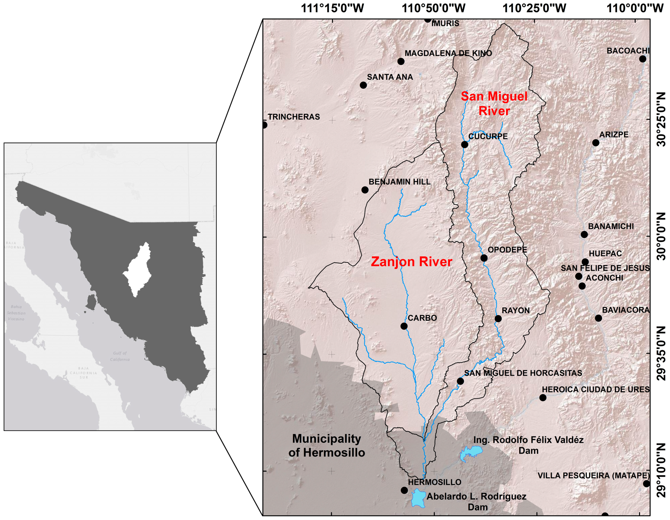
2.1. Study Area
2.2. Mapping Critical Areas for Carbon Storage
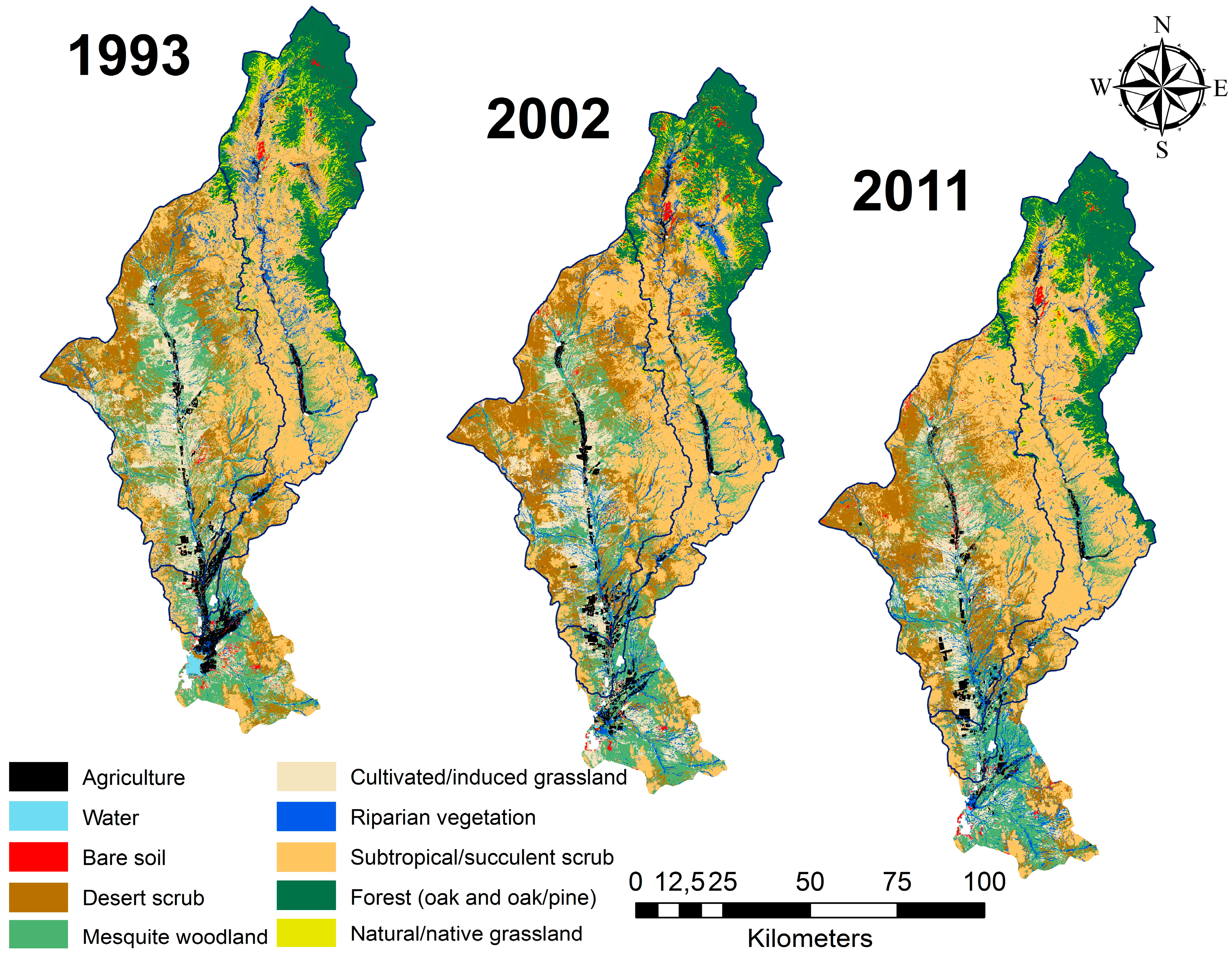
2.2.1. Land Use and Cover Classification
2.2.2. Carbon Storage by Land Cover Type
- (a)
- Aerial biomass per land cover type was estimated using the NFI information for the study area (Appendix A). Each NFI sampling unit is called a “conglomerate” and, in arid zones, has an area of 1600 m2 [44]. The diameter at breast height (DBH) data was used to calculate biomass per species in each “conglomerate”, applying the allometric equations reported in the literature [45,46]. Each “conglomerate” sample size was between 7 and 39 trees (depending on land cover type), and the total biomass by conglomerate was estimated in ton/ha.
- (b)
- Aerial biomass of cultivated/induced grassland (not included in the NFI sampling sites), was obtained from regional studies regarding this variable [34], using similar sites to the land cover type of interest.
- (c)
- Aerial biomass of perennial and annual agriculture was obtained from the “Servicio de Información Agroalimentaria y Pesquera” database [35].
- (d)
- For the riparian ecosystems of the SMR (Riparian vegetation), which differs from Riparian mesquite (composed mainly by Prosopis, Cercidium, Acacia) due to the floristic composition (species of the genera Populus, Salix, Bacharis, etc.), no information was found in the NFI or in the literature. Therefore, eight field-sampling sites were established (with a sample size of 28 trees per site) using the NFI protocol, in which the DBH was measured (using only trees that had over 7.5 DBH) in order to enable the use of species-specific allometric equations (Appendix B).
- (e)
- (f)
2.2.3. Spatiotemporal Changes in Carbon Storage
2.3. Productivity Estimations and Trends
2.3.1. Vegetation Indices as Proxies for Productivity
2.3.2. Comparing Basal and Pre-Monsoon Productivity
2.3.3. Trends on Basal and Pre-Monsoon Productivity
2.4. Temperature, Precipitation, Runoff and Water Depth Effects on Productivity Trends
3. Results
3.1. Carbon Storage
3.1.1. Carbon Stocks and Allocation
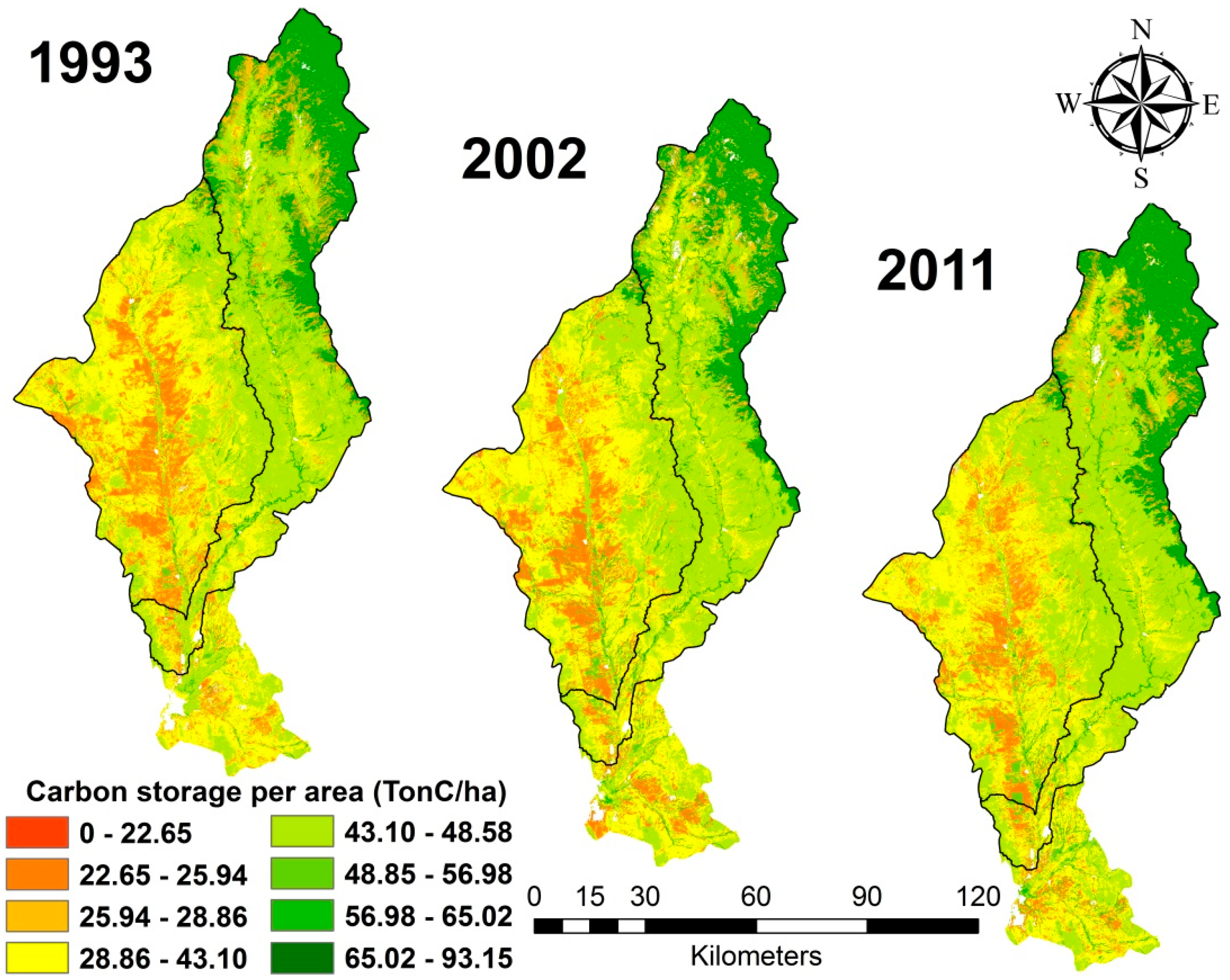
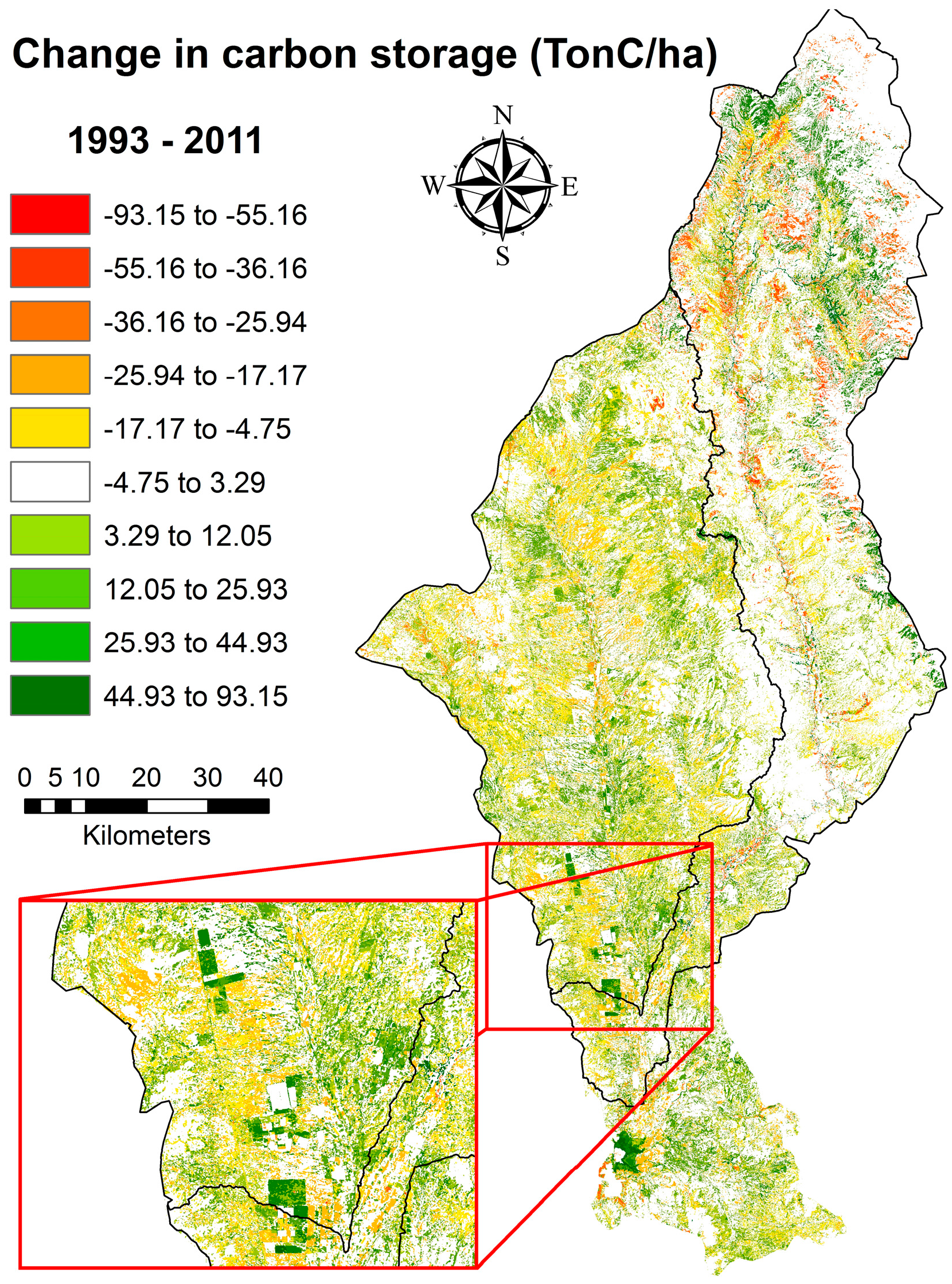
3.1.2. Spatial Distribution of the Carbon Storage
3.1.3. Spatiotemporal Changes in Carbon Storage
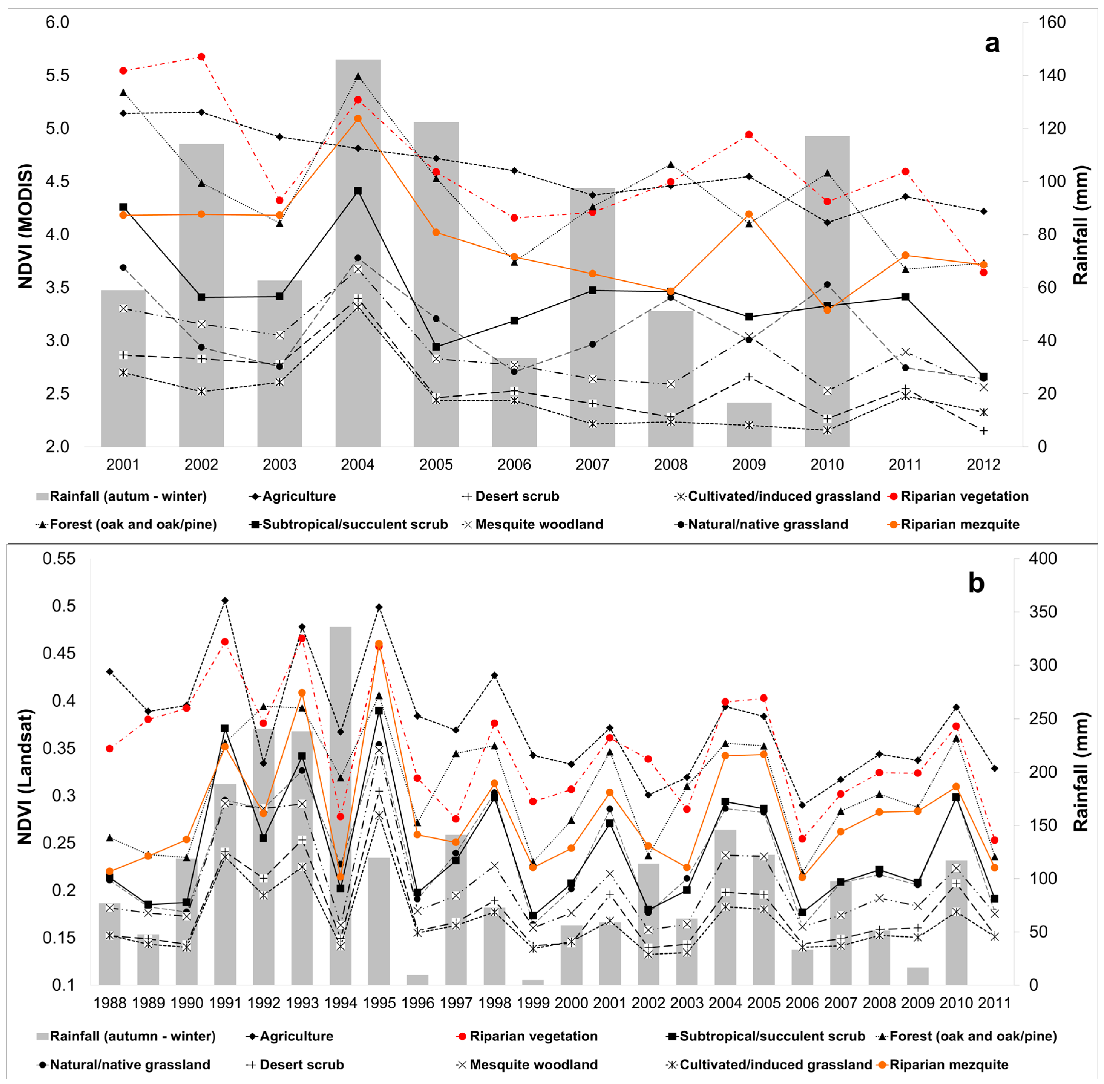
3.2. Differences in Productivity per Land Cover Type
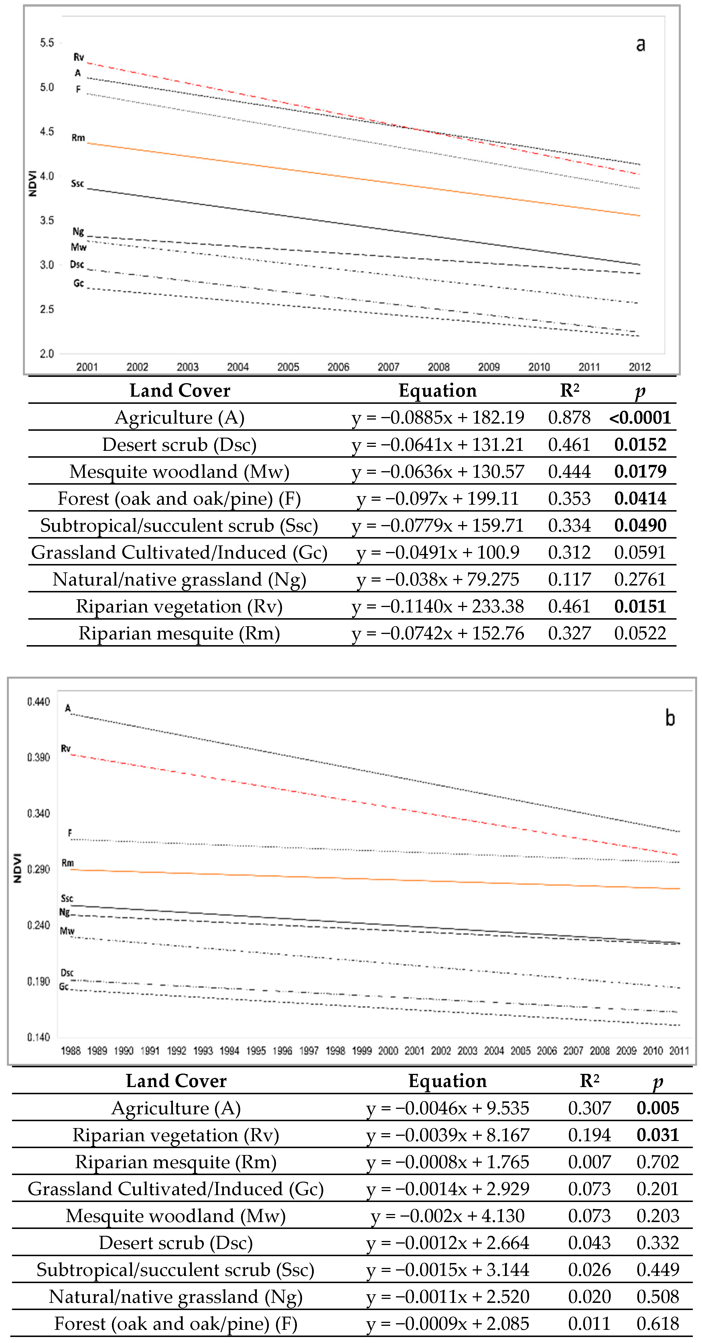
3.3. Trends in productivity
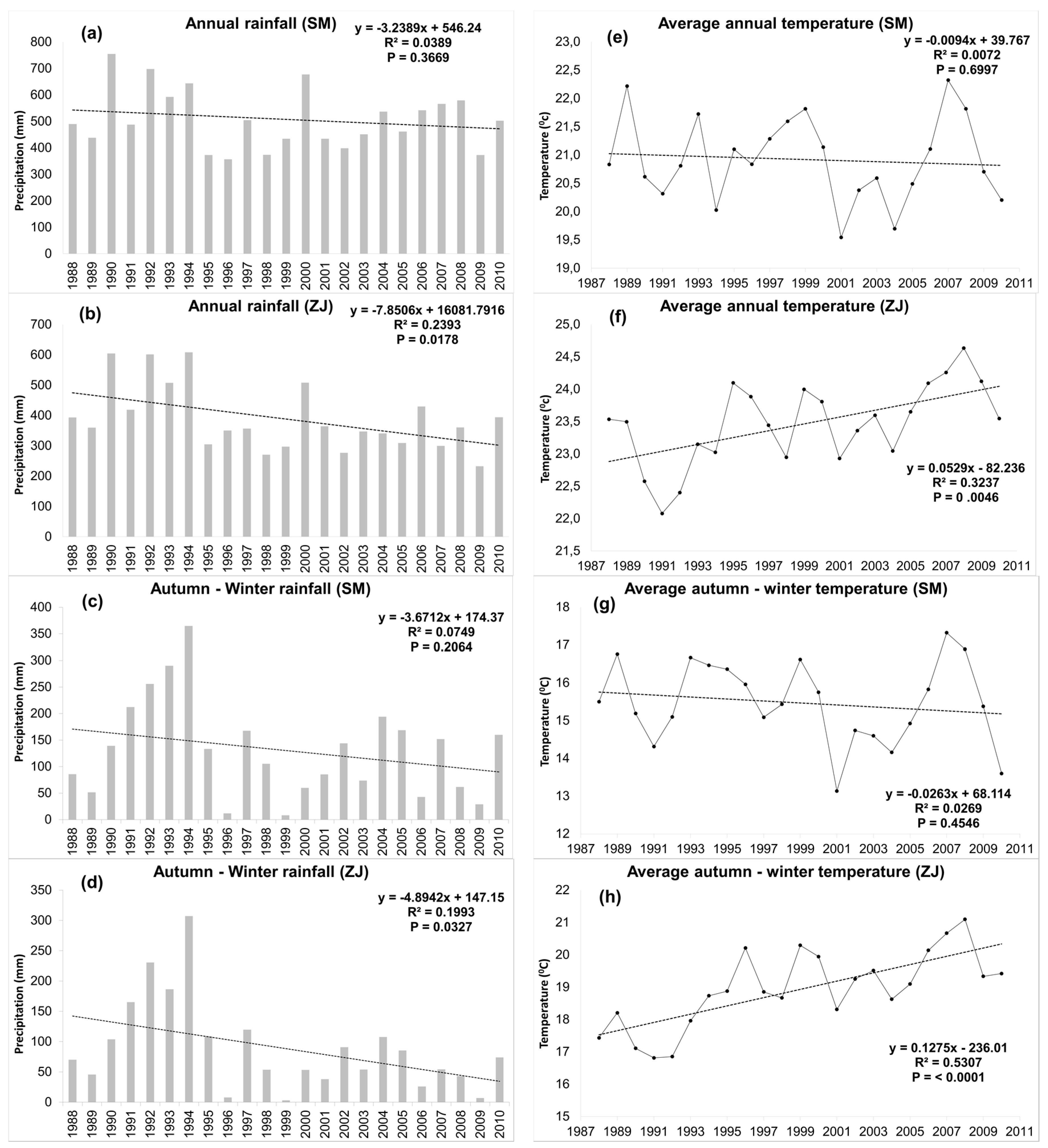
3.4. Decrease in Productivity and Its Possible Causes
3.5. Productivity in Sites with Changes in Land Cover
4. Discussion
4.1. Carbon Storage in the REAZ
4.2. Productivity Differences and Trends
5. Conclusions
- There is a decrease in the time of the basal and pre-monsoon productivity of the REAZ. This is partly due to the drier conditions observed during the previous decades in the region, partly provoked by ENSO dominance in recent years [71].
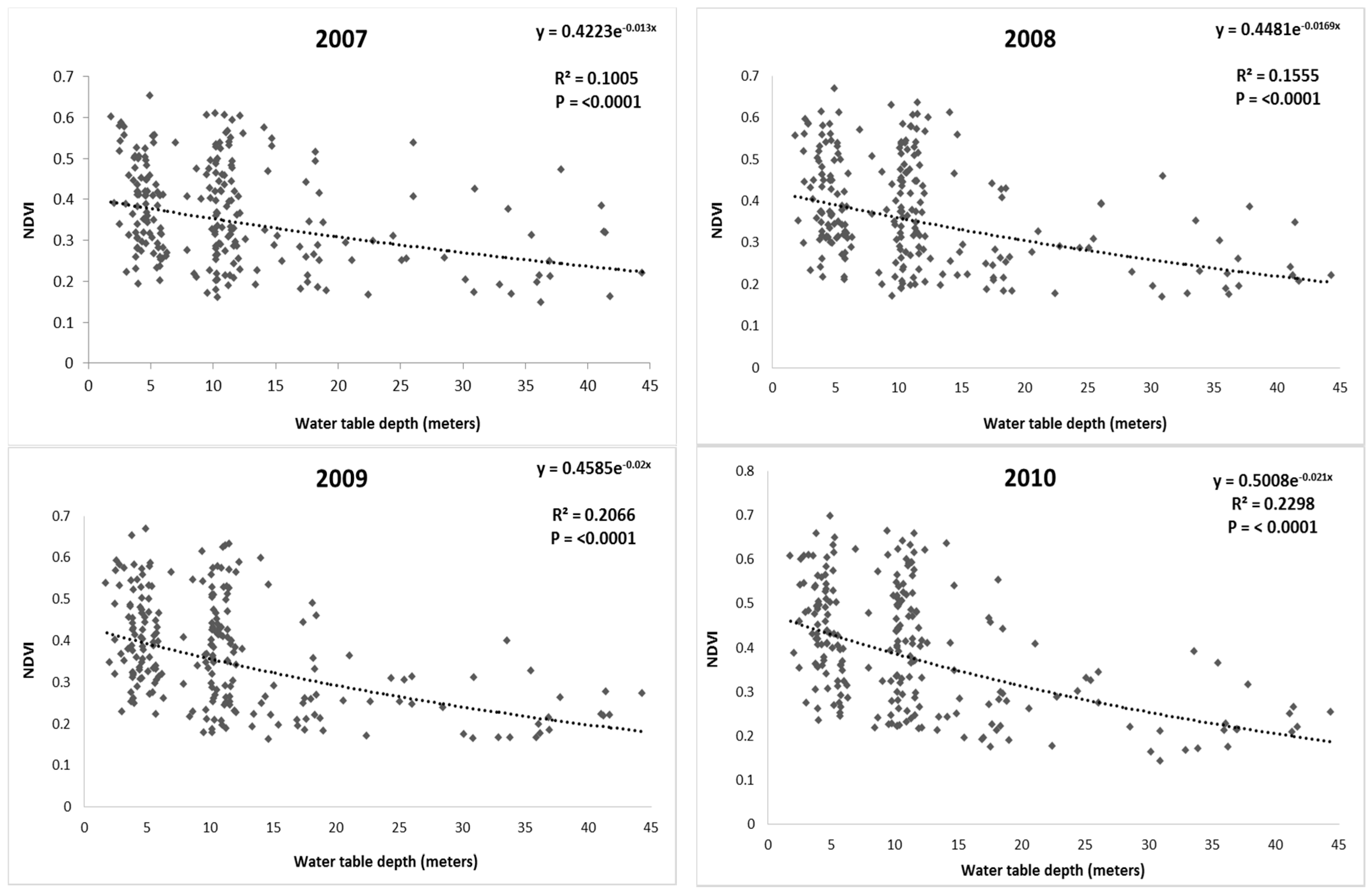
- Productivity of riparian vegetation decreases with the increased depth of the static levels of subterranean water.
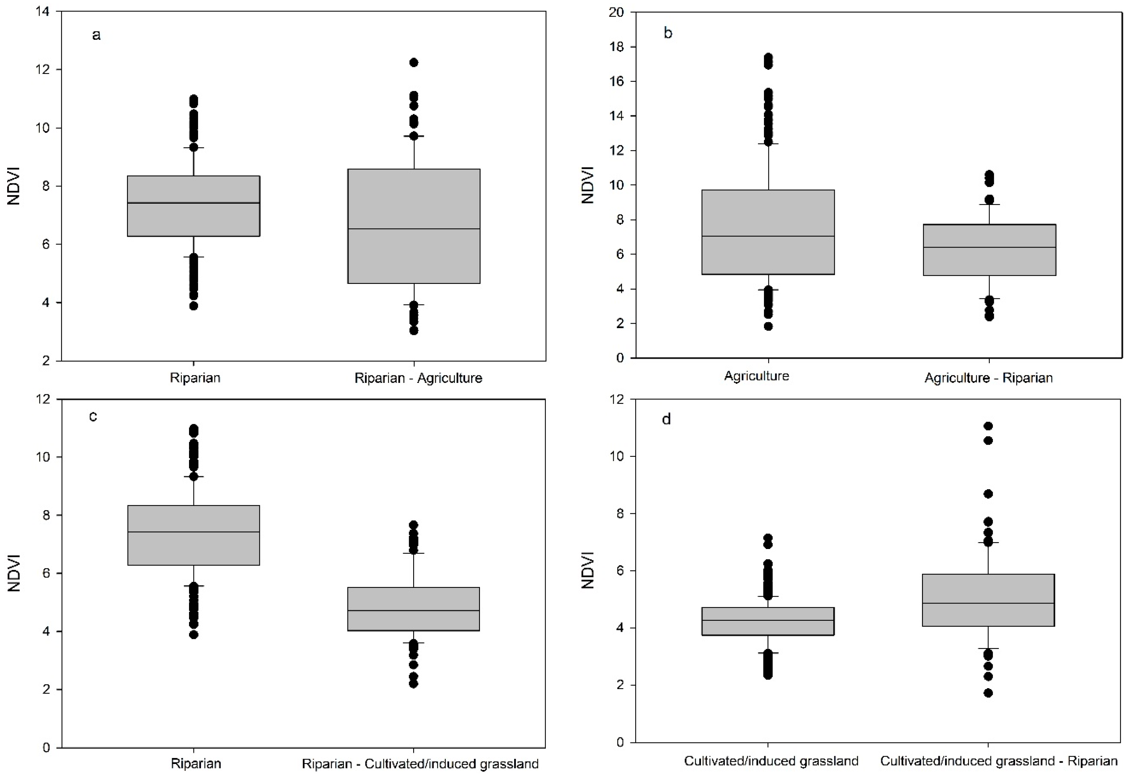
- Productivity decreases in sites where the REAZ has transformed to other land cover types.
- In sites where there is an intensive use of water and soil, a transition is seen between strictly riparian (genera Populus and Salix) and facultative (genera Prosopis, Acacia and Celtis) species.
Acknowledgments
Author Contributions
Conflicts of Interest
Appendix A

Appendix B

| Land Cover Type | Data Utilized | Sources of Information |
| Forest (oak/oak–pine) | NFI sampling points (63) | Allometric equations for above-ground biomass |
| Acacia farnesiana [72] | ||
| Arbutus arizonica, Arctostaphylos pungens, Cupressus arizonica, Fraxinus gooddingii, Garrya wrightii, Juniperus spp, J. coahuilensis, J. deppeana, J. monosperma, Prosopis juliflora, P. velutina, Quercus sp., Q. chiapasensis, Q. chihuahuensis, Q. depressipes, Q. turbinella, Q. toumeyi, Q. viminea, Q. crassifolia, Q. arizonica, Q. grisea, Q. Hypoleucoides, Q. oblongifolia, Q. laurifolia, Rhus choriophylla [45] | ||
| Eysenhardtia orthocarpa [9] | ||
| Lysiloma watsonii, L. divaricatum, Pinus engelmannii, P. leiophylla, Quercus sideroxyla [73] | ||
| Pinus cembroides [74] | ||
| Prosopis glandulosa [75] | ||
| Quercus castanea [76] | ||
| Shoot: root biomass [39] | ||
| Soil organic carbon [36] | ||
| Desert scrub | NFI sampling points (46) | Allometric equations for above-ground biomass |
| Acacia constricta, A. occidentalis, Bumelia sp., Forchammeria watsonii, Prosopis glandulosa, P. juliflora, P. velutina [45] | ||
| Bursera fagaroides, B. hindsiana, Cercidium microphyllum, C. sonorae, Eysenhardtia orthocarpa, Fouquieria macdougalii, Olneya tesota, Parkinsonia microphylla, P. praecox, P. florida, Guaiacum coulteri [9] | ||
| Celtis pallida, Condalia globosa [72] | ||
| Lysiloma divaricatum, L. watsonii [73] | ||
| Shoot: root biomass [39] | ||
| Soil organic carbon [40] | ||
| Mesquite woodland | NFI sampling points (31) | Allometric equations for abov- ground biomass |
| Acacia farnesiana, Celtis pallida, Condalia globosa [72] | ||
| Ipomoea arborescens [77] | ||
| Acacia occidentalis, Havardia mexicana, Prosopis glandulosa, P. juliflora, P. velutina [45] | ||
| Bursera hindsiana, B. microphylla, B. laxiflora and B. lancifolia, Cercidium microphyllum, C. sonorae, Eysenhardtia orthocarpa, Fouquieria macdougalii, Guaiacum coulteri, Jatropha cordata, Olneya tesota, Opuntia thurberi, O. versicolor, Parkinsonia microphylla, P. praecox, P. florida, Randia thurberi, Sideroxylon occidentale, Pithecellobium dulce [9] | ||
| Shoot: root biomass [39] | ||
| Soil organic carbon [36] | ||
| Subtropical/succulent scrub | NFI sampling points (34) | Allometric equations for abov- ground biomass |
| Acacia colicantha [78] | ||
| Ceiba acuminata, C. pentandra, Erythrina flabelliformis, Ipomoea arborescens, Lysiloma divaricatum, L. watsonii [73] | ||
| Celtis pallida, C. reticulate [72] | ||
| Acacia cymbispina, A. occidentalis, A. greggii, A. willardiana, Diphysa suberosa, Prosopis glandulosa, P. juliflora, P. velutina [45] | ||
| Bursera fagaroides, B. hindsiana, Cercidium sonorae, C. praecox, Eysenhardtia orthocarpa, E. polystachya, Fouquieria macdougalii, Guaiacum coulteri, Jatropha cordata, Olneya tesota, Opuntia wilcoxii, O. arbuscula, O. thurberi, Parkinsonia microphylla, P. praecox, P. aculeata [9] | ||
| Shoot: root biomass [37] | ||
| Soil organic carbon [36] | ||
| Riparian vegetation (includes Riparian mesquite) | NFI sampling points (15), field sampling points (n = 8) | Allometric equations for above-ground biomass |
| Parkinsonia microphylla, Parkinsonia aculeata, Olneya tesota, Guaiacum coulteri, Jatropha cordata, Cercidium sonorae, C. microphyllum, Eysenhardtia orthocarpa, Bursera microphylla, B. hindsiana, Opuntia thurberi, Randia thurberi [9] | ||
| Prosopis velutina, P. juliflora, Prosopis sp., Acacia occidentalis, Havardia mexicana, Populus sp, Salix sp., Bacharis sp., Hymenoclea monogyra, Celtis pallida, Vallesia glabra, Phaulothamnus spinescens, Acacia occidentalis [45] | ||
| Celtis pallida, Condalia globosa, Acacia farnesiana [72] | ||
| Ipomoea arborescens [73] | ||
| Shoot: root biomass [39] | ||
| Soil organic carbon [36] | ||
| Natural/native grassland | NFI sampling points (13) | Allometric equations for above-ground biomass |
| Chilopsis linearis, Juniperus deppeana, Juniperus monticola, Juniperus coahuilensis, Prosopis laevigata, P. velutina, P. juliflora, P. glandulosa, Quercus arizonica, Q. chihuahuensis, Q. depressipes, Q. emoryi, Q. grisea, Q. oblongifolia [45] | ||
| Lysiloma watsonii, Quercus sideroxyla [73] | ||
| Shoot: root biomass [38] | ||
| Soil organic carbon [40] | ||
| Cultivated/induced grassland | Regional survey | Above-ground biomass [34] |
| Shoot: root biomass [38] | ||
| Soil organic carbon [40] | ||
| Agriculture | Official data | Above-ground biomass [35,41,43] |
| Shoot: root biomass [37] | ||
| Soil organic carbon [40] |
References
- Baker, B.M.; Ffolliott, P.F.; Debano, L.F.; Neary, D.G. Riparian Areas of the Southwestern United States: Hydrology, Ecology, and Management; Lewis Publishers; CRC Press: Boca Raton, FL, USA, 2004; p. 408. [Google Scholar]
- Patten, D.T. Riparian ecosytems of semi-arid north america: Diversity and human impacts. Wetlands 1998, 18, 498–512. [Google Scholar] [CrossRef]
- Zaimes, G.; Nichols, M.; Green, D.; Crimmins, M. Understanding Arizona’s Riparian Areas; College of Agriculture and Life Sciences, University of Arizona: Tucson, AZ, USA, 2007; Available online: http://extension.arizona.edu/sites/extension.arizona.edu/files/pubs/az1432.pdf (accessed on 4 August 2016).
- Pase, C.P.; Layser, E.F. Classification of riparian habitat in the southwest. In Importance, Preservation, and Management of Riparian Habitat: A Symposium; Johnson, R.R., Jones, D.A., Eds.; U.S. Department of Agriculture: Fort Collins, CO, USA, 1977; pp. 5–9. [Google Scholar]
- Granados-Sánchez, D.; Hernández-García, M.; López-Ríos, G. Ecología de las zonas ribereñas. Rev. Chapingo Ser. 2006, 12, 55–69. (In Spanish) [Google Scholar]
- Rood, S.B.; Mahoney, J.M. Collapse of riparian poplar forests downstream from dams in western prairies: Probable causes and prospects for mitigation. Environ. Manag. 1990, 14, 451–464. [Google Scholar] [CrossRef]
- Tufekcioglu, A.; Raich, J.; Isenhart, T.; Schultz, R. Biomass, carbon and nitrogen dynamics of multi-species riparian buffers within an agricultural watershed in iowa, USA. Agrofor. Syst. 2003, 57, 187–198. [Google Scholar] [CrossRef]
- Hazlett, P.; Gordon, A.; Sibley, P.; Buttle, J. Stand carbon stocks and soil carbon and nitrogen storage for riparian and upland forests of boreal lakes in northeastern ontario. For. Ecol. Manag. 2005, 219, 56–68. [Google Scholar] [CrossRef]
- Búrquez, A.; Martínez-Yrízar, A.; Núñez, S.; Quintero, T.; Aparicio, A. Aboveground biomass in three sonoran desert communities: Variability within and among sites using replicated plot harvesting. J. Arid Environ. 2010, 74, 1240–1247. [Google Scholar] [CrossRef]
- Egoh, B.; Reyers, B.; Rouget, M.; Richardson, D.M.; Le Maitre, D.C.; van Jaarsveld, A.S. Mapping ecosystem services for planning and management. Agric. Ecosyst. Environ. 2008, 127, 135–140. [Google Scholar] [CrossRef]
- Assessment, M.E. Ecosystems and Human Well-Being; Island Press: Washington, DC, USA, 2005; Volume 5. [Google Scholar]
- Balvanera, P. Los servicios ecosistémicos que ofrecen los bosques tropicales. Rev. Ecosistemas 2012, 21, 136–147. (In Spanish) [Google Scholar]
- Loomis, J.; Kent, P.; Strange, L.; Fausch, K.; Covich, A. Measuring the total economic value of restoring ecosystem services in an impaired river basin: Results from a contingent valuation survey. Ecol. Econ. 2000, 33, 103–117. [Google Scholar] [CrossRef]
- Orúe, M.E.; Booman, G.C.; Laterra, P. Uso de la Tierra, Configuración del Paisaje y el Filtrado de Sedimentos y Nutrientes por Humedales y Vegetación Ribereña. Valoración de Servicios Ecosistémicos: Conceptos, Herramientas y Aplicaciones Para el Ordenamiento Territorial; INTA Ediciones: Buenos Aires, Argentina, 2011; pp. 237–254. (In Spanish) [Google Scholar]
- Sweeney, B.W.; Bott, T.L.; Jackson, J.K.; Kaplan, L.A.; Newbold, J.D.; Standley, L.J.; Hession, W.C.; Horwitz, R.J. Riparian deforestation, stream narrowing, and loss of stream ecosystem services. Proc. Natl. Acad. Sci. USA 2004, 101, 14132–14137. [Google Scholar] [CrossRef] [PubMed]
- Huete, A.; Didan, K.; van Leeuwen, W.; Miura, T.; Glenn, E. Modis vegetation indices. In Land Remote Sensing and Global Environmental Change; Springer: New York, NY, USA, 2010; pp. 579–602. [Google Scholar]
- Altesor, A.; Barral, M.P.; Booman, G.; Carreño, L.; Cristeche, E.; Isacch, J.P.; Maceira, N.; Pérez, N. Servicios Ecosistémicos: Un Marco Conceptual en Construcción. Aspectos Conceptuales y Operativos. Expansión e Intensificación Agrícola en Argentina: Valoración de Bienes y Servicios Ecosistémicos Para el Ordenamiento Territorial; INTA Ediciones: Buenos Aires, Argentina, 2010. (In Spanish) [Google Scholar]
- Root, T.L.; Price, J.T.; Hall, K.R.; Schneider, S.H.; Rosenzweig, C.; Pounds, J.A. Fingerprints of global warming on wild animals and plants. Nature 2003, 421, 57–60. [Google Scholar] [CrossRef] [PubMed]
- Deng, S.; Shi, Y.; Jin, Y.; Wang, L. A gis-based approach for quantifying and mapping carbon sink and stock values of forest ecosystem: A case study. Energy Procedia 2011, 5, 1535–1545. [Google Scholar] [CrossRef]
- Bagstad, K.J.; Semmens, D.J.; Winthrop, R. Comparing approaches to spatially explicit ecosystem service modeling: A case study from the san pedro river, arizona. Ecosyst. Serv. 2013, 5, 40–50. [Google Scholar] [CrossRef]
- Ordoñez, D.; Antonio, B.; Caballero, M.; Jiménez, I.; Carmona, J.; Galicia, A.; Calvo, F.; Balam, M.; Rojas, R.; Jiménez, J. Estimación del Carbono Almacenado en Pinus Hartwegii en el Parque Nacional Izta-Popo, Zoquiapan. Estado Actual del Conocimiento del Ciclo del Carbono y sus Interacciones en Mexico; Programa Mexicano del Carbono, Universidad Autónoma del Estado de Mexico e Instituto Nacional de Ecología: Texcoco, Mexico, 2012; pp. 680–684. (In Spanish) [Google Scholar]
- Ruesch, A.; Gibbs, H.K. New IPCC Tier1 Global Biomass Carbon Map For the Year 2000; Carbon Dioxide Information Analysis Center, Oak Ridge National Laboratory: Oak Ridge, Tennessee, 2008. Available online: http://cdiac.ornl.gov (accessed on 4 September 2016).
- Postel, S.; Richter, B. Rivers for Life: Managing Water for People and Nature; Island Press: Washington, DC, USA, 2012. [Google Scholar]
- Scott, M.L.; Nagler, P.L.; Glenn, E.P.; Valdes-Casillas, C.; Erker, J.A.; Reynolds, E.W.; Shafroth, P.B.; Gomez-Limon, E.; Jones, C.L. Assessing the extent and diversity of riparian ecosystems in sonora, mexico. Biodivers. Conserv. 2009, 18, 247–269. [Google Scholar] [CrossRef]
- Mendez-Estrella, R.; Romo-Leon, J.R.; Castellanos, A.E.; Gandarilla-Aizpuro, F.J.; Hartfield, K. Analyzing landscape trends on agriculture, introduced exotic grasslands and riparian ecosystems in arid regions of mexico. Remote Sens. 2016, 8, 664. [Google Scholar] [CrossRef]
- Comisión Nacional para el Conocimiento y Uso de la Biodiversidad (CONABIO). ‘Subcuencas hidrológicas‘. Extraído de Boletín Hidrológico. (1970). Subcuencas Hidrológicas en Mapas de Regiones Hidrológicas. Escala más Común 1:1,000,000. Secretaría de Recursos Hidraúlicos; Jefatura de Irrigación y control de Ríos, Dirección de Hidrología: Ciudad de México, Mexico, 1998. (In Spanish) [Google Scholar]
- Comisión Nacional del Agua (CONAGUA). Actualización de la Disponibilidad Media Anual de Agua Subterránea. Acuífero (2626) río Zanjón, Estado de Sonora; Diario Oficial de la Federación: Ciudad de México, Mexico, 2009. (In Spanish) [Google Scholar]
- Comisión Nacional del Agua (CONAGUA). Actualización de la Disponibilidad Media Anual de Agua Subterránea. Acuífero (2625) río san Miguel, Estado de Sonora; Diario Oficial de la Federación: Ciudad de México, Mexico, 2009. (In Spanish) [Google Scholar]
- Anderson, J.R. A Land Use and Land Cover Classification System for Use with Remote Sensor Data; US Government Printing Office: Washington, DC, USA, 1976; Volume 964.
- Rzedowski, J. Vegetación de Mexico, 1st ed.; Comisión Nacional para el Conocimiento y Uso de la Biodiversidad: Tialpan, Mexico, 2006; p. 504. (In Spanish) [Google Scholar]
- Shreve, F.; Wiggins, I.L. Vegetation and Flora of the Sonoran Desert; Stanford University Press: Stanford, CA, USA, 1964; Volumes 1 and 2. [Google Scholar]
- Congalton, R.G.; Green, K. Assessing the Accuracy of Remotely Sensed Data: Principles and Practices; CRC Press: Boca Raton, FL, USA, 2008. [Google Scholar]
- Vashum, K.T.; Jayakumar, S. Methods to estimate above-ground biomass and carbon stock in natural forests—A review. J. Ecosyst. Ecogr. 2012. [Google Scholar] [CrossRef]
- Franklin, K.A.; Lyons, K.; Nagler, P.L.; Lampkin, D.; Glenn, E.P.; Molina-Freaner, F.; Markow, T.; Huete, A.R. Buffelgrass (pennisetum ciliare) land conversion and productivity in the plains of sonora, Mexico. Biol. Conserv. 2006, 127, 62–71. [Google Scholar] [CrossRef]
- SIAP-SAGARPA. Producción Agrícola por Estado. Available online: http://www.Siap.Gob.Mx/cierre-de-la-produccion-agricola-por-estado/ (accessed on 15 January 2016).
- Gálvez, R.O.P.R.; Dávalos, R.P.; De Jong, E.S.D.; Álvarez, B.H.J.O. Evaluación de los Recursos Forestales Mundiales 2010. Informe Nacional Mexico; Organización de las Naciones Unidas para la Agricultura y la Alimentación: Rome, Italy, 2010. (In Spanish) [Google Scholar]
- Jackson, R.; Canadell, J.; Ehleringer, J.R.; Mooney, H.; Sala, O.; Schulze, E. A global analysis of root distributions for terrestrial biomes. Oecologia 1996, 108, 389–411. [Google Scholar] [CrossRef] [PubMed]
- Johnson, M.V.V. Pennisetum Ciliare Invasion: Mechanisms and Effects; Texas A&M University: Kingsville, TX, USA, 2007. [Google Scholar]
- Mokany, K.; Raison, R.; Prokushkin, A.S. Critical analysis of root: Shoot ratios in terrestrial biomes. Glob. Chang. Biol. 2006, 12, 84–96. [Google Scholar] [CrossRef]
- Segura-Castruita, M.A.; Sánchez-Guzmán, P.; Ortiz-Solorio, C.A.; del Carmen Gutiérrez-Castorena, M. Carbono orgánico de los suelos de Mexico. Terra Latinoam. 2005, 23, 21–28. (In Spanish) [Google Scholar]
- Carvajal, M.; Mota, C.; Alcaraz-López, C.; Iglesias, M. Investigación Sobre la Absorción de CO2 por los Cultivos más Representativos. Available online: http://cambioclimaticomurcia.carm.es/pdfs/lessco2/ponencia_cisc_espanol.pdf (accessed on 3 November 2014).
- Stromberg, J. Root patterns and hydrogeomorphic niches of riparian plants in the american southwest. J. Arid Environ. 2013, 94, 1–9. [Google Scholar] [CrossRef]
- Smith, M.W.; Wood, B.W. Pecan tree biomass estimates. HortScience 2006, 41, 1286–1291. [Google Scholar]
- The National Foreatry Commission (CONAFOR). Inventario Nacional Forestal y de Suelos. Informe 2004–2009; Forestal, C.N., Ed.; CONAFOR: Zapopan, Jalisco, Mexico, 2012. (In Spanish) [Google Scholar]
- Jenkins, J.C.; Chojnacky, D.C.; Heath, L.S.; Birdsey, R.A. National-scale biomass estimators for united states tree species. For. Sci. 2003, 49, 12–35. [Google Scholar]
- Rojas-García, F.; De Jong, B.H.; Martínez-Zurimendí, P.; Paz-Pellat, F. Database of 478 allometric equations to estimate biomass for mexican trees and forests. Ann. For. Sci. 2015, 72, 835–864. [Google Scholar] [CrossRef]
- Intergovernmental Panel on Climate Change (IPCC). 2006 IPCC Guidelines for National Greenhouse Gas Inventories; Prepared by the National Greenhouse Gas Inventories Programme; Eggleston, H.S., Buendia, L., Miwa, K., Ngara, T., Tanabe, K., Eds.; Intergovernmental Panel on Climate Change: Hayama, Japan, 2006. [Google Scholar]
- Alatorre, L.C.; Sánchez-Carrillo, S.; Miramontes-Beltrán, S.; Medina, R.J.; Torres-Olave, M.E.; Bravo, L.C.; Wiebe, L.C.; Granados, A.; Adams, D.K.; Sánchez, E. Temporal changes of ndvi for qualitative environmental assessment of mangroves: Shrimp farming impact on the health decline of the arid mangroves in the gulf of california (1990–2010). J. Arid Environ. 2016, 125, 98–109. [Google Scholar] [CrossRef]
- Nguyen, U.; Glenn, E.P.; Nagler, P.L.; Scott, R.L. Long-term decrease in satellite vegetation indices in response to environmental variables in an iconic desert riparian ecosystem: The upper san pedro, arizona, united states. Ecohydrology 2015, 8, 610–625. [Google Scholar] [CrossRef]
- Tucker, C.; Sellers, P. Satellite remote sensing of primary production. Int. J. Remote Sens. 1986, 7, 1395–1416. [Google Scholar] [CrossRef]
- Fu, B.; Burgher, I. Riparian vegetation ndvi dynamics and its relationship with climate, surface water and groundwater. J. Arid Environ. 2015, 113, 59–68. [Google Scholar] [CrossRef]
- Mather, P.; Tso, B. Classification Methods for Remotely Sensed Data; CRC Press: Boca Raton, FL, USA, 2009. [Google Scholar]
- Jönsson, P.; Eklundh, L. Timesat—A program for analyzing time-series of satellite sensor data. Comput. Geosci. 2004, 30, 833–845. [Google Scholar] [CrossRef]
- Kogan, F. Application of vegetation index and brightness temperature for drought detection. Adv. Space Res. 1995, 15, 91–100. [Google Scholar] [CrossRef]
- Day, R.W.; Quinn, G.P. Comparisons of treatments after an analysis of variance in ecology. Ecol. Monogr. 1989, 59, 433–463. [Google Scholar] [CrossRef]
- Servicio Meteorológico Nacional (SMN). Red de Estaciones Climatológicas. Available online: smn1.conagua.gob.mx/climatologia/normales/estacion/EstacionesClimatologicas.kmz (accesed on 20 September 2016).
- Comisión Nacional del Agua (CONAGUA). Estaciones hidrométricas. Mexico Subdir. Gen. Téc. 2012. unpublished data. (In Spanish) [Google Scholar]
- Joneidi Jafari, H. Relationship between root biomass and soil organic carbon: Case study of arid shrub lands of semnan province. Desert 2013, 18, 173–176. [Google Scholar]
- Eswaran, H.; Van Den Berg, E.; Reich, P. Organic carbon in soils of the world. Soil Sci. Soc. Am. J. 1993, 57, 192–194. [Google Scholar] [CrossRef]
- Díaz-Caravantes, R.E.; Sánchez-Flores, E. Water transfer effects on peri-urban land use/land cover: A case study in a semi-arid region of mexico. Appl. Geogr. 2011, 31, 413–425. [Google Scholar] [CrossRef]
- Méndez-Barroso, L.A.; Vivoni, E.R.; Watts, C.J.; Rodríguez, J.C. Seasonal and interannual relations between precipitation, surface soil moisture and vegetation dynamics in the north american monsoon region. J. Hydrol. 2009, 377, 59–70. [Google Scholar] [CrossRef]
- Comisión Nacional del Agua (CONAGUA). Programa de Medidas Preventivas y de Mitigación de la Sequía Para el Consejo de Cuenca Alto Noroeste. Programa Nacional Contra la Sequía (Pronacose). Available online: http://www.Pronacose.Gob.Mx/pronacose14/contenido/documentos/imta_conagua%20cuenca%20noroeste%20salida.Pdf (accessed on 18 November 2015).
- Castellanos, A.E.; Yanes, G.; Valdéz, D. Drought-tolerant exotic buffel-grass and desertification. In Weeds across Borders: Proceedings of a North American Conference; Tellman, B., Ed.; The Sonora-Arizona Desert Museum: Tucson, AZ, USA, 2002; pp. 99–112. [Google Scholar]
- Asner, G.P.; Archer, S.; Hughes, R.F.; Ansley, R.J.; Wessman, C.A. Net changes in regional woody vegetation cover and carbon storage in Texas drylands, 1937–1999. Glob. Chang. Biol. 2003, 9, 316–335. [Google Scholar] [CrossRef]
- Wang, G.; Oyana, T.; Zhang, M.; Adu-Prah, S.; Zeng, S.; Lin, H.; Se, J. Mapping and spatial uncertainty analysis of forest vegetation carbon by combining national forest inventory data and satellite images. For. Ecol. Manag. 2009, 258, 1275–1283. [Google Scholar] [CrossRef]
- Van Leeuwen, W.J.; Huete, A.R.; Laing, T.W. Modis vegetation index compositing approach: A prototype with avhrr data. Remote Sens. Environ. 1999, 69, 264–280. [Google Scholar] [CrossRef]
- Bai, Z.G.; Dent, D.L.; Olsson, L.; Schaepman, M.E. Proxy global assessment of land degradation. Soil Use Manag. 2008, 24, 223–234. [Google Scholar] [CrossRef]
- Moreno-Vazquez, J.L.; Centro de Estudios del Desarrollo de El Colegio de Sonora (COLSON), Hermosillo, Sonora, México. El fortalecimiento de la resilencia de corredores riparios áridos: Ecohidrología y toma de decisiones en la cuenca del río san miguel. 2012. unpublished work (In Spanish) [Google Scholar]
- Comisión Nacional del Agua (CONAGUA). Localizador Repda de Aguas Nacionales, Zonas Federales y Descargas de Aguas Residuales (Locrepda), Segunda Versión en Google Earth. Capa de Datos Geográficos de los Aprovechamientos de Agua Superficial Inscritos del Registro Público de Derechos de Agua Repda. 2012. Available online: http://sigagis.Conagua.Gob.Mx/locrepda/ (accessed on 15 July 2015).
- Williams, C.A.; Cooper, D.J. Mechanisms of riparian cottonwood decline along regulated rivers. Ecosystems 2005, 8, 382–395. [Google Scholar] [CrossRef]
- Hallack-Alegria, M.; Watkins, D.W., Jr. Annual and warm season drought intensity–duration–frequency analysis for Sonora, Mexico. J. Clim. 2007, 20, 1897–1909. [Google Scholar] [CrossRef]
- Návar, J.; Nájera, J.; Jurado, E. Preliminary estimates of biomass growth in the tamaulipan thornscrub in north-eastern mexico. J. Arid Environ. 2001, 47, 281–290. [Google Scholar] [CrossRef]
- Návar, J. Allometric equations for tree species and carbon stocks for forests of northwestern mexico. For. Ecol. Manag. 2009, 257, 427–434. [Google Scholar] [CrossRef]
- Guerrero Silva, L.P. Cuantificación de Biomasa, Carbono y Producción de Oxigeno de Pinus Cembroides Zucc. En Mazapíl, Zacatecas, Mexico. Undergraduate thesis, Universidad Autónoma Agraria Antonio Narro, Saltillo, Mexico, 2014. (In Spanish). [Google Scholar]
- González, J.M.; Méndez, A.S.; Luna, J.A.N.; Ontiveros, V.G. Modelos para estimar volumen y biomasa de árboles individuales de Prosopis glandulosa, var. Torreyana en el ejido jesús gonzález ortega n° 1, mpio. De mexicali, bc. Agrofaz Publ. Semest. Investig. Cient. 2006, 6, 225–240. (In Spanish) [Google Scholar]
- Aguilar, R.; Ghilardi, A.; Vega, E.; Skutsch, M.; Oyama, K. Sprouting productivity and allometric relationships of two oak species managed for traditional charcoal making in central mexico. Biomass Bioenergy 2012, 36, 192–207. [Google Scholar] [CrossRef]
- Návar, J. Alometría para biomasa en especies arbóreas del noroeste de Mexico. Trop. Subtrop. Agroecosyst. 2010, 12, 507–519. (In Spanish) [Google Scholar]
- Návar Chaidez, J.d.J. Allometric equations and expansion factors for tropical dry trees of eastern sinaloa, mexico. Trop. Subtrop. Agroecosyst. 2008, 10, 45–52. [Google Scholar]


| Region | Climatological Stations |
|---|---|
| Zanjón River | 00026074 Querobabi |
| 00026016 Carbó | |
| 00026182 Pesqueira | |
| San Miguel River | 00026025 Cucurpe |
| 00026241 Meresichic | |
| 00026064 Opodepe | |
| 00026181 Rayón | |
| 00026180 El Cajón |
| Land Cover | Aboveground Carbon (Tonc/ha) | Belowground Carbon (Tonc/ha) | Soil Carbon (Tonc/ha) | Total Carbon (Tonc/ha) | ||||
|---|---|---|---|---|---|---|---|---|
| Mean | σ | Data Source | Mean | σ | Root: Shoot Ratio and Source of Data | Organic Carbon Values and Source of Data | ||
| Riparian vegetation | 33.47 | 17.08 | Allometric equations and data obtained in field work (8 sampling plots, mean sample size of 28 trees by plot) | 10.72 | 2.92 | 0.320 [36,42] | 48.95 [36] | 93.147 |
| Forest (oak and oak/pine) | 11.0 | 8.47 | Allometric equations and data obtained in the NFI (63 sampling plots, mean sample size of 39 trees by plot) | 3.25 | 2.50 | 0.295 [39] | 50.8 [36] | 65.048 |
| Riparian mesquite | 4.02 | 1.14 | Allometric equations and data obtained in the NFI (12 sampling plots, mean sample size of 19 trees by plot) | 4.27 | 1.22 | 1.063 [39] | 48.95 [36] | 57.245 |
| Perennial agriculture | 6.10 | 5.10 | Records [35,43] | 1.95 | 1.83 | 0.319 [43] | 40.8 [40] | 48.850 |
| Subtropical/succulent scrub | 2.91 | 2.66 | Allometric equations and data obtained in the NFI (36 sampling plots, mean sample size of 17 trees by plot) | 1.64 | 1.50 | 0.563 [39] | 43.52 [36] | 48.064 |
| Irrigated agriculture | 2.22 | 1.51 | Records [35,41] | 0.13 | 0.10 | 0.059 [41] | 40.8 [40] | 43.155 |
| Mesquite woodland | 3.48 | 2.89 | Allometric equations and data obtained in the NFI (31 sampling plots, mean sample size of 7 trees by plot) | 3.70 | 3.07 | 1.063 [39] | 31.48 [36] | 38.664 |
| Desert scrub | 2.39 | 1.78 | Allometric equations and data obtained in the NFI (46 sampling plots, mean sample size of 7 trees by plot) | 2.54 | 1.89 | 1.063 [39] | 24 [40] | 28.929 |
| Natural/native grassland | 2.85 | 2.35 | Allometric equations and data obtained in the NFI (13 sampling plots, mean sample size of 15 trees by plot) | 1.99 | 1.64 | 0.7 [37] | 21.4 [40] | 26.251 |
| Cultivated/induced grassland | 0.74 | 0.13 | Bibliography [34] | 0.61 | 0.10 | 0.82 [38] | 21.4 [40] | 22.754 |
| Land Cover | Pixels (30 × 30 m) | Cover (Ha) | Carbon per Unit Area (TonC/ha) | Total Carbon (Ton) |
|---|---|---|---|---|
| Subtropical/succulent Scrub | 3,528,729.00 | 317,585.61 | 48.06 | 15,264,434.76 |
| Forest (oak and oak/pine) | 1,347,073.00 | 121,236.57 | 65.05 | 7,886,196.41 |
| Mesquite woodland | 1,614,070.00 | 145,266.30 | 38.66 | 5,616,576.22 |
| Desert scrub | 1,715,565.00 | 154,400.85 | 28.93 | 4,466,662.19 |
| Riparian mesquite | 496,849.00 | 44,716.41 | 57.25 | 2,559,790.89 |
| Cultivated/induced grassland | 945,453.00 | 85,090.77 | 22.75 | 1,936,155.38 |
| Riparian vegetation | 113,194.00 | 10,187.46 | 93.15 | 948,931.34 |
| Natural/native grassland | 357,958.00 | 32,216.22 | 26.25 | 845,707.99 |
| Irrigated agriculture | 165,361.00 | 14,882.49 | 43.16 | 642,253.86 |
| Perennial agriculture | 52,803.00 | 4752.27 | 48.85 | 232,148.39 |
| Comparison | 2001 | 2002 | 2003 | 2004 | 2005 | 2006 | |||||||
|---|---|---|---|---|---|---|---|---|---|---|---|---|---|
| Ranks | Q | Ranks | Q | Ranks | Q | Ranks | Q | Ranks | Q | Ranks | Q | ||
| Riparian vegetation | Rv vs. A | 548.4 | 5.4 | 342.1 | 3.4 | 86.8 | 0.9 | 460.2 | 4.5 | 311.1 | 3.1 | 267.8 | 2.6 |
| Rv vs. Dsc | 2060.3 | 25.5 | 1553.4 | 19.2 | 1304.8 | 16.2 | 1260.8 | 15.6 | 1742.0 | 21.6 | 1832.8 | 22.7 | |
| Rv vs. F | 100.3 | 1.2 | 453.6 | 5.4 | 253.3 | 3.0 | 5.1 | 0.1 | 23.1 | 0.3 | 489.1 | 5.8 | |
| Rv vs. Gc | 2252.6 | 28.2 | 1868.0 | 23.4 | 1556.0 | 19.5 | 1374.4 | 17.2 | 1689.7 | 21.1 | 2004.2 | 25.1 | |
| Rv vs. Mw | 1516.7 | 18.3 | 1209.7 | 14.6 | 943.4 | 11.4 | 980.3 | 11.8 | 1219.2 | 14.7 | 1369.4 | 16.5 | |
| Rv vs. Ng | 1164.1 | 8.2 | 1595.4 | 11.2 | 1413.1 | 9.9 | 1071.7 | 7.5 | 852.9 | 6.0 | 1639.7 | 11.5 | |
| Rv vs. Rm | 710.5 | 4.7 | 328.1 | 2.2 | 68.2 | 0.4 | 47.9 | 0.3 | 99.3 | 0.7 | 193.0 | 1.3 | |
| Rv vs. Ssc | 615.2 | 8.3 | 928.4 | 12.5 | 804.3 | 10.8 | 462.6 | 6.2 | 1174.5 | 15.8 | 835.4 | 11.2 | |
| Riparian mesquite | Rm vs. A | 162.2 | 1.0 | 14.0 | 0.1 | 18.6 | 0.1 | 508.1 | 3.3 | 211.8 | 1.4 | 74.8 | 0.5 |
| Rm vs. Dsc | 1349.8 | 9.4 | 1225.3 | 8.6 | 1236.7 | 8.7 | 1308.6 | 9.2 | 1642.7 | 11.5 | 1639.8 | 11.5 | |
| Rm vs. F | 610.2 | 4.2 | 125.5 | 0.9 | 185.2 | 1.3 | 42.7 | 0.3 | 122.4 | 0.8 | 296.1 | 2.0 | |
| Rm vs. Gc | 1542.1 | 10.8 | 1540.0 | 10.8 | 1487.8 | 10.4 | 1422.2 | 10.0 | 1590.4 | 11.2 | 1811.1 | 12.7 | |
| Rm vs. Mw | 806.1 | 5.6 | 881.7 | 6.1 | 875.2 | 6.1 | 1028.2 | 7.1 | 1119.9 | 7.8 | 1176.4 | 8.2 | |
| Rm vs. Ng | 453.5 | 2.5 | 1267.4 | 6.9 | 1344.9 | 7.3 | 1119.6 | 6.1 | 753.7 | 4.1 | 1446.6 | 7.8 | |
| Rm vs. Ssc | 95.3 | 0.7 | 600.3 | 4.3 | 736.1 | 5.3 | 510.5 | 3.7 | 1075.2 | 7.7 | 642.4 | 4.6 | |
| Comparison | 2007 | 2008 | 2009 | 2010 | 2011 | 2012 | |||||||
| Ranks | Q | Ranks | Q | Ranks | Q | Ranks | Q | Ranks | Q | Ranks | Q | ||
| Riparian vegetation | Rv vs. A | 232.8 | 2.3 | 376.9 | 3.7 | 456.3 | 4.5 | 415.3 | 4.1 | 591.6 | 5.8 | 213.0 | 2.1 |
| Rv vs. Dsc | 1486.6 | 18.4 | 1984.9 | 24.6 | 1680.5 | 20.8 | 1944.0 | 24.1 | 1956.3 | 24.2 | 1584.5 | 19.6 | |
| Rv vs. F | 115.1 | 1.4 | 101.8 | 1.2 | 579.7 | 6.9 | 218.3 | 2.6 | 566.3 | 6.7 | 130.6 | 1.5 | |
| Rv vs. Gc | 1705.8 | 21.3 | 2032.5 | 25.4 | 2188.9 | 27.4 | 2021.5 | 25.3 | 2030.0 | 25.4 | 1277.7 | 16.0 | |
| Rv vs. Mw | 1188.3 | 14.3 | 1577.6 | 19.0 | 1246.4 | 15.0 | 1581.3 | 19.1 | 1484.2 | 17.9 | 969.9 | 11.7 | |
| Rv vs. Ng | 1046.6 | 7.4 | 700.3 | 4.9 | 1453.5 | 10.2 | 467.2 | 3.3 | 1714.1 | 12.1 | 1064.2 | 7.5 | |
| Rv vs. Rm | 274.8 | 1.8 | 655.1 | 4.3 | 244.3 | 1.6 | 705.1 | 4.6 | 348.8 | 2.3 | 19.1 | 0.1 | |
| Rv vs. Ssc | 515.3 | 6.9 | 647.8 | 8.7 | 1114.4 | 15.0 | 640.1 | 8.6 | 742.7 | 10.0 | 1049.9 | 14.1 | |
| Riparian mesquite | Rm vs. A | 42.0 | 0.3 | 278.2 | 1.8 | 212.0 | 1.4 | 238.0 | 1.3 | 242.8 | 1.6 | 232.1 | 1.5 |
| Rm vs. Dsc | 1211.8 | 8.5 | 1329.8 | 9.3 | 1436.1 | 10.1 | 289.8 | 1.9 | 1607.5 | 11.3 | 1603.6 | 11.2 | |
| Rm vs. F | 159.7 | 1.1 | 757.0 | 5.2 | 335.4 | 2.3 | 1238.8 | 8.7 | 217.5 | 1.5 | 149.7 | 1.0 | |
| Rm vs. Gc | 1431.0 | 10.1 | 1377.4 | 9.7 | 1944.6 | 13.7 | 923.4 | 6.4 | 1681.2 | 11.8 | 1296.8 | 9.1 | |
| Rm vs. Mw | 913.5 | 6.3 | 922.5 | 6.4 | 1002.0 | 7.0 | 1316.3 | 9.2 | 1135.4 | 7.9 | 989.0 | 6.9 | |
| Rm vs. Ng | 771.8 | 4.2 | 45.2 | 0.2 | 1209.2 | 6.6 | 876.2 | 6.1 | 1365.3 | 7.4 | 1083.3 | 5.9 | |
| Rm vs. Ssc | 240.5 | 1.7 | 7.3 | 0.1 | 870.0 | 6.2 | 65.1 | 0.5 | 393.9 | 2.8 | 1069.0 | 7.7 | |
| Proxy of Pre-Monsoon Productivity of the Riparian Vegetation (Landsat) | |||||
|---|---|---|---|---|---|
| Statistical Parameters | Average Annual Temperature | Average Temperature Autumn–Winter | Annual Accumulated Precipitation | Accumulated Precipitation Autumn–Winter | Annual Runoff Volume |
| Correlation Coefficient | −0.123 | −0.185 | −0.0439 | 0.356 | 0.186 |
| p Value | 0.575 | 0.397 | 0.842 | 0.0957 | 0.397 |
| Number of Samples | 23 | 23 | 23 | 23 | 23 |
| Proxy of basal productivity of the riparian vegetation (MODIS) | |||||
| Correlation Coefficient | −0.639 | −0.513 | −0.563 | 0.178 | 0.383 |
| p Value | 0.0468 * | 0.13 | 0.0903 | 0.623 | 0.274 |
| Number of Samples | 10 | 10 | 10 | 10 | 10 |
| Proxy of Pre-Monsoon Productivity of the Riparian Mesquite (Landsat) | ||||
|---|---|---|---|---|
| Statistical Parameters | Average Annual Temperature | Average Temperature Autumn–Winter | Annual Accumulated Precipitation | Accumulated Precipitation Autumn–Winter |
| Correlation Coefficient | −0.143 | −0.245 | −0.144 | 0.205 |
| p Value | 0.515 | 0.259 | 0.512 | 0.349 |
| Number of Samples | 23 | 23 | 23 | 23 |
| Proxy of basal productivity of the riparian mesquite (MODIS) | ||||
| Correlation Coefficient | −0.618 | −0.664 | −0.304 | 0.362 |
| p Value | 0.0569 | 0.0362 * | 0.394 | 0.304 |
| Number of Samples | 10 | 10 | 10 | 10 |
© 2017 by the authors. Licensee MDPI, Basel, Switzerland. This article is an open access article distributed under the terms and conditions of the Creative Commons Attribution (CC BY) license (http://creativecommons.org/licenses/by/4.0/).
Share and Cite
Mendez-Estrella, R.; Romo-Leon, J.R.; Castellanos, A.E. Mapping Changes in Carbon Storage and Productivity Services Provided by Riparian Ecosystems of Semi-Arid Environments in Northwestern Mexico. ISPRS Int. J. Geo-Inf. 2017, 6, 298. https://doi.org/10.3390/ijgi6100298
Mendez-Estrella R, Romo-Leon JR, Castellanos AE. Mapping Changes in Carbon Storage and Productivity Services Provided by Riparian Ecosystems of Semi-Arid Environments in Northwestern Mexico. ISPRS International Journal of Geo-Information. 2017; 6(10):298. https://doi.org/10.3390/ijgi6100298
Chicago/Turabian StyleMendez-Estrella, Romeo, Jose Raul Romo-Leon, and Alejandro E. Castellanos. 2017. "Mapping Changes in Carbon Storage and Productivity Services Provided by Riparian Ecosystems of Semi-Arid Environments in Northwestern Mexico" ISPRS International Journal of Geo-Information 6, no. 10: 298. https://doi.org/10.3390/ijgi6100298
APA StyleMendez-Estrella, R., Romo-Leon, J. R., & Castellanos, A. E. (2017). Mapping Changes in Carbon Storage and Productivity Services Provided by Riparian Ecosystems of Semi-Arid Environments in Northwestern Mexico. ISPRS International Journal of Geo-Information, 6(10), 298. https://doi.org/10.3390/ijgi6100298