
Collaborative Strategies for Sustainable EU Flood Risk Management: FOSS and Geospatial Tools—Challenges and Opportunities for Operative Risk Analysis


Abstract
:1. Introduction
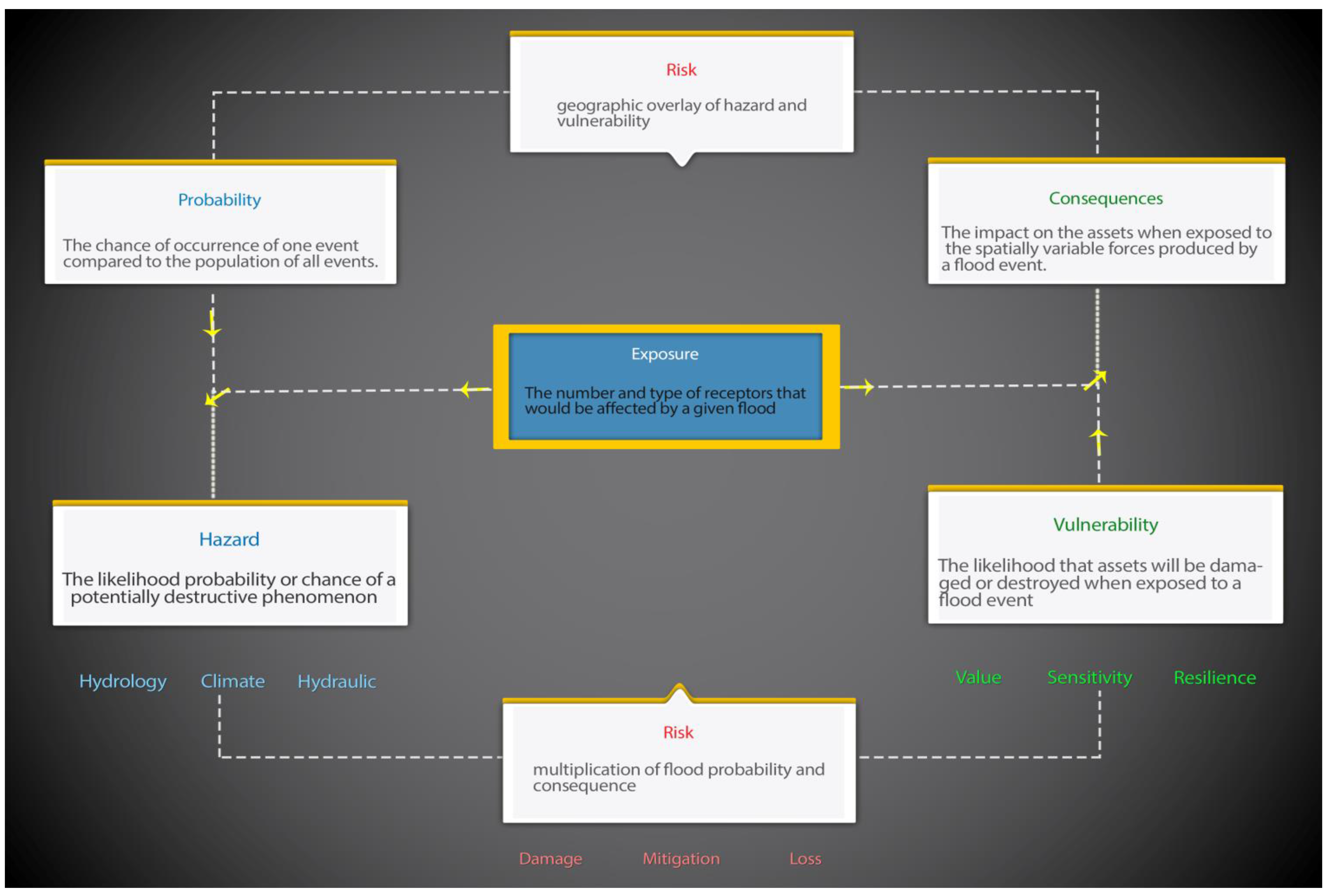
2. Basic Flood Risk Concepts
3. Conceptual Overview of Common Practices for Risk Analysis Models
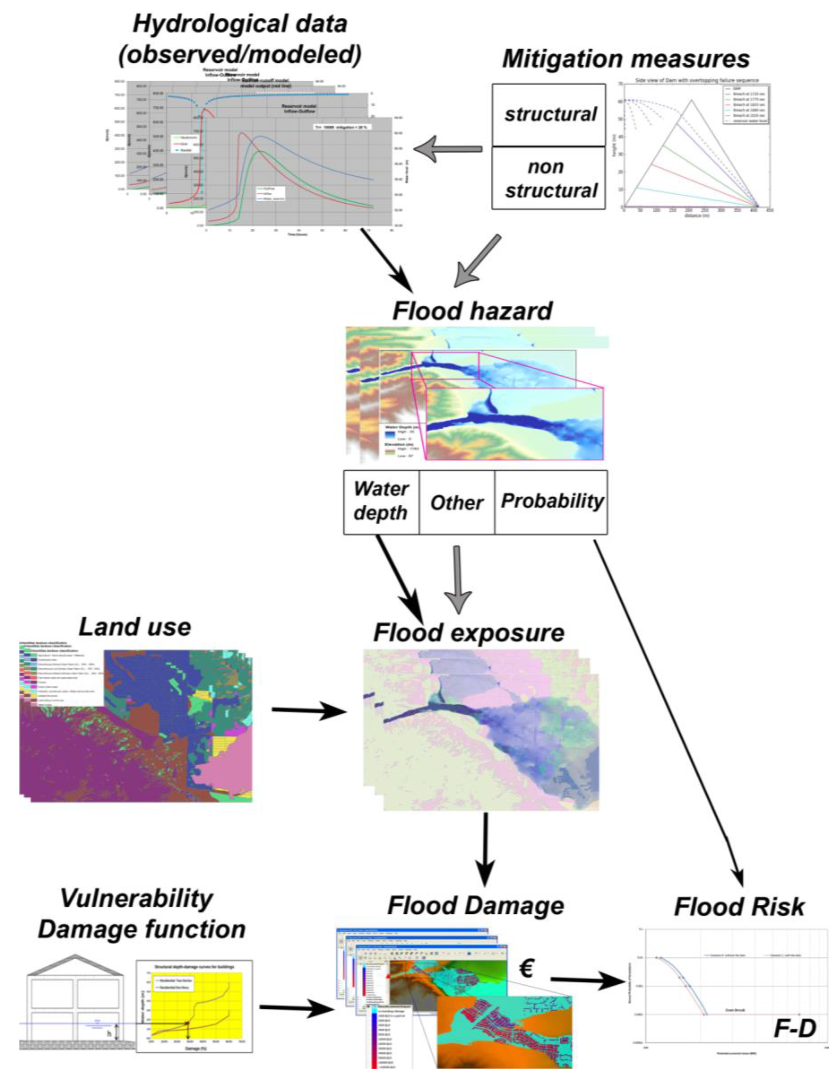
4. General Approach for Flood Risk Analysis Models

5. Current Advances and Barriers to Implementation for Risk Analysis Models
5.1. Cultivate and Promote Open-Data and the Communication of Uncertainty Information
5.2. Challenge in Developing a Harmonized European Approach while Providing Room for Including Necessary Regional Adjustments
5.2.1. Spatial Scales

| Scale Level | Data Needs | Study Area | Scope | Accuracy | Efforts |
|---|---|---|---|---|---|
| macro | low/aggregated | global/international | (re)insurance/global policy | low | low |
| meso | land-use | regional | flood protection strategies | middle | middle |
| micro | land-use or object type | local | local flood mitigation measures | high | high |
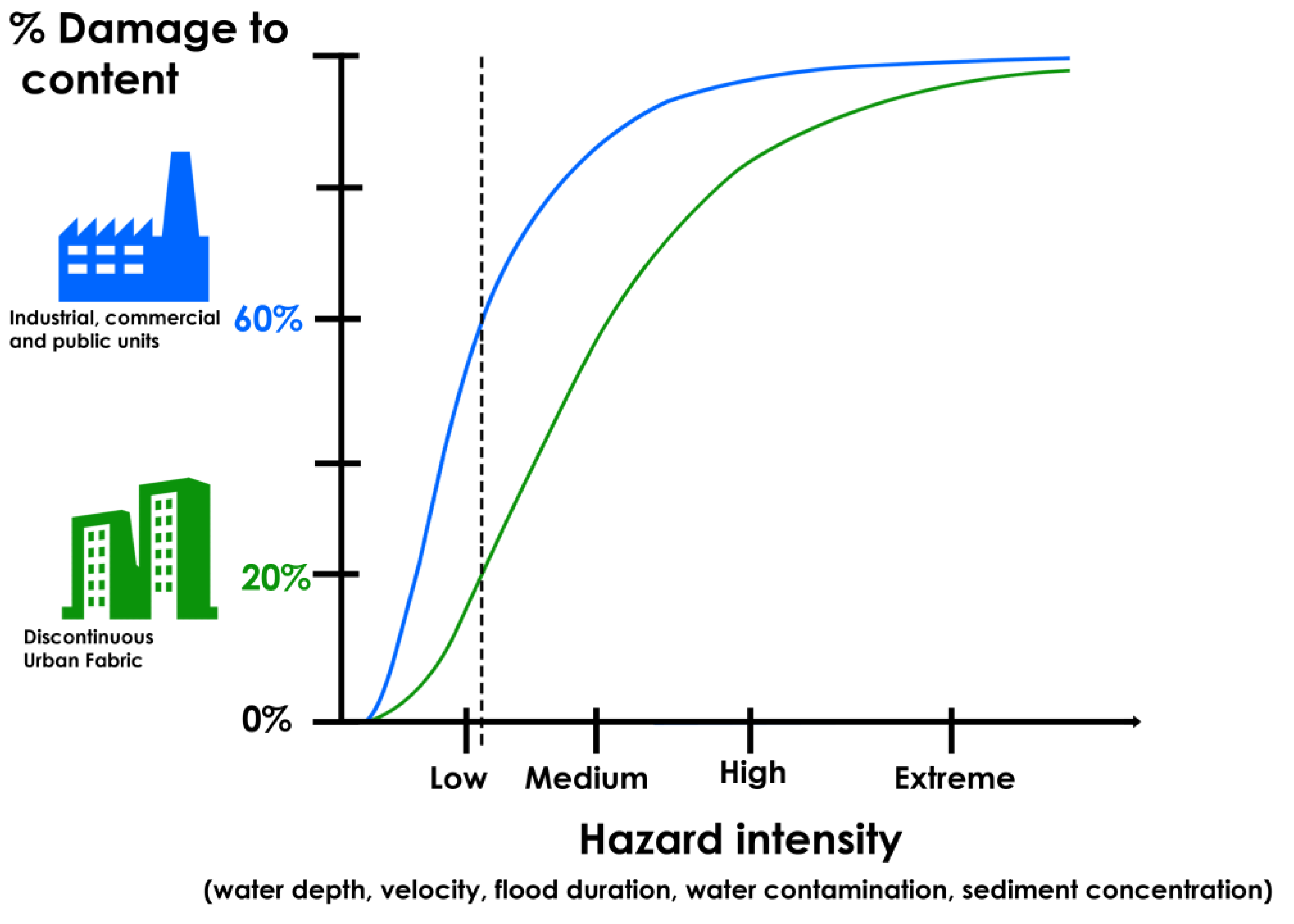
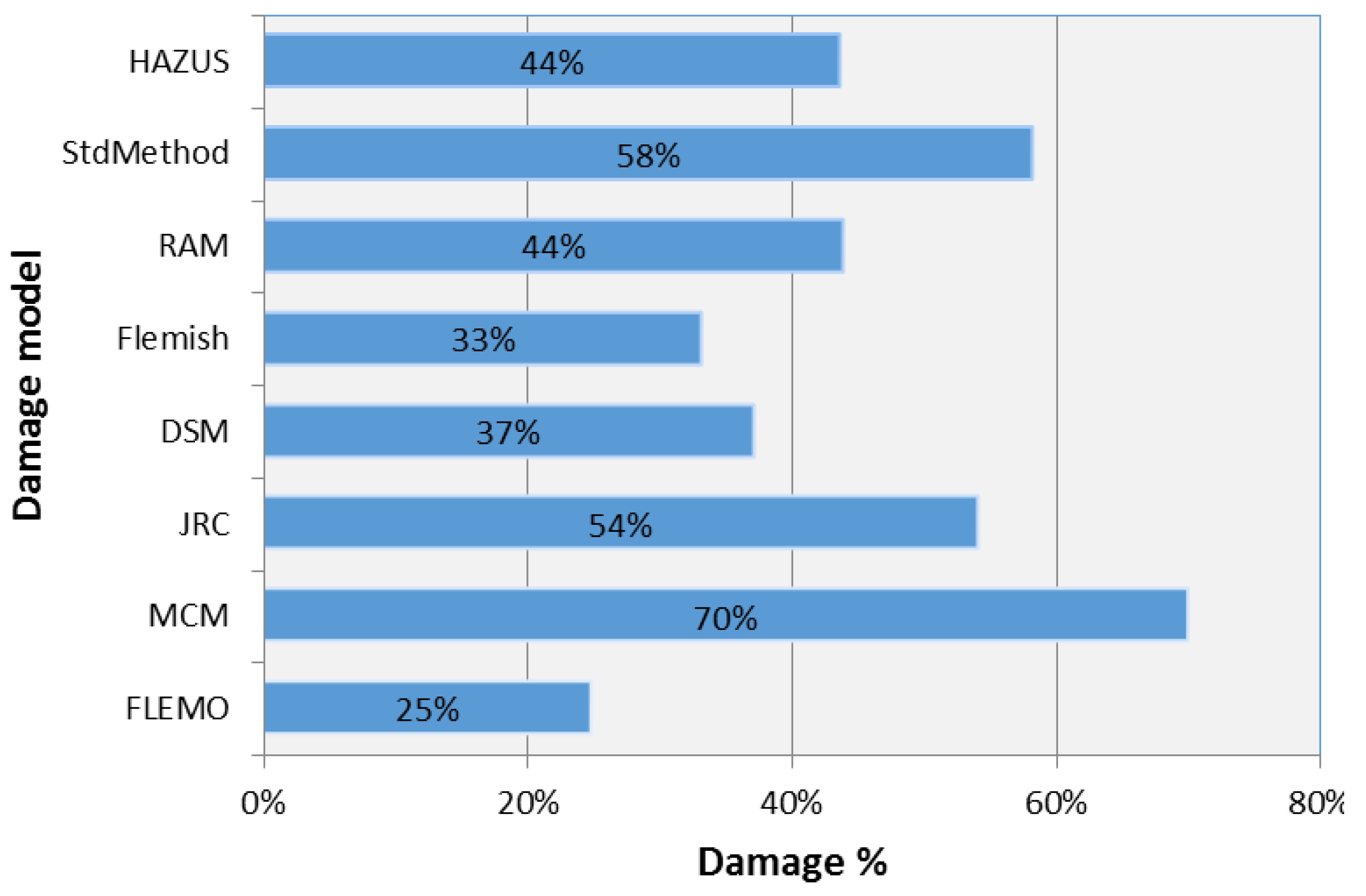
5.2.2. Large Differences in the Application of Several Scientific Flood Damage Models
| Damage Model | Country | Scale of Application | Units of Analysis | Hydrological Character | Data Method | Num. of Unit Class | Refer. |
|---|---|---|---|---|---|---|---|
| HAZUS | USA | Local Regional | Individual objects Surface area | Depth, Duration Velocity, Debris Rate of rise | Empirical synthetic | >20 | [42] |
| Standard Method | Netherland | Local Regional | Individual objects Surface area | Depth Flow rate | Synthetic | >20 | [43] |
| Rhine Atlas | Germany | Local Regional | Surface area | Depth | Empirical synthetic | 10–20 | [44] |
| Flemish | Belgium | Regional National | Surface area | Depth | Synthetic | 5–10 | [45] |
| Damage Scanner | Netherland | Regional National | Surface area | Depth | Synthetic | 5–10 | [46] |
| JRC Model | Europe | Regional National European | Surface area | Depth | Empirical synthetic (Statistical) | 5–10 | [47] |
| MCM | England | Local Regional | Individual objects | Depth | Synthetic | >20 | [48] |
| FLEMO | Germany | Local Regional National | Surface area | Depth Contamination | Empirical | 5–10 | [49] |
| CODE | Description |
|---|---|
| 11100 | Continuous Urban Fabric (S.L. > 80%) |
| 11210 | Discontinuous Dense Urban Fabric (S.L.: 50%–80%) |
| 11220 | Discontinuous Medium Density Urban Fabric (S.L.: 30%–50%) |
| 11230 | Discontinuous Low Density Urban Fabric (S.L.: 10%–30%) |
| 11240 | Discontinuous Very Low Density Urban Fabric (S.L. < 10%) |
| 11300 | Isolated Structures |
| 12100 | Industrial, commercial, public, military and private units |
| 12210 | Fast transit roads and associated land |
| 12220 | Other roads and associated land |
| 12230 | Railways and associated land |
| 12300 | Port areas |
| 12400 | Airports |
| 13100 | Mineral extraction and dump sites |
| 13300 | Construction sites |
| 13400 | Land without current use |
| 14100 | Green urban areas |
| 14200 | Sports and leisure facilities |
| 20000 | Agricultural + Semi-natural areas + Wetlands |
| 30000 | Forests |
| 40000 | Wetlands |
| 50000 | Water bodies |

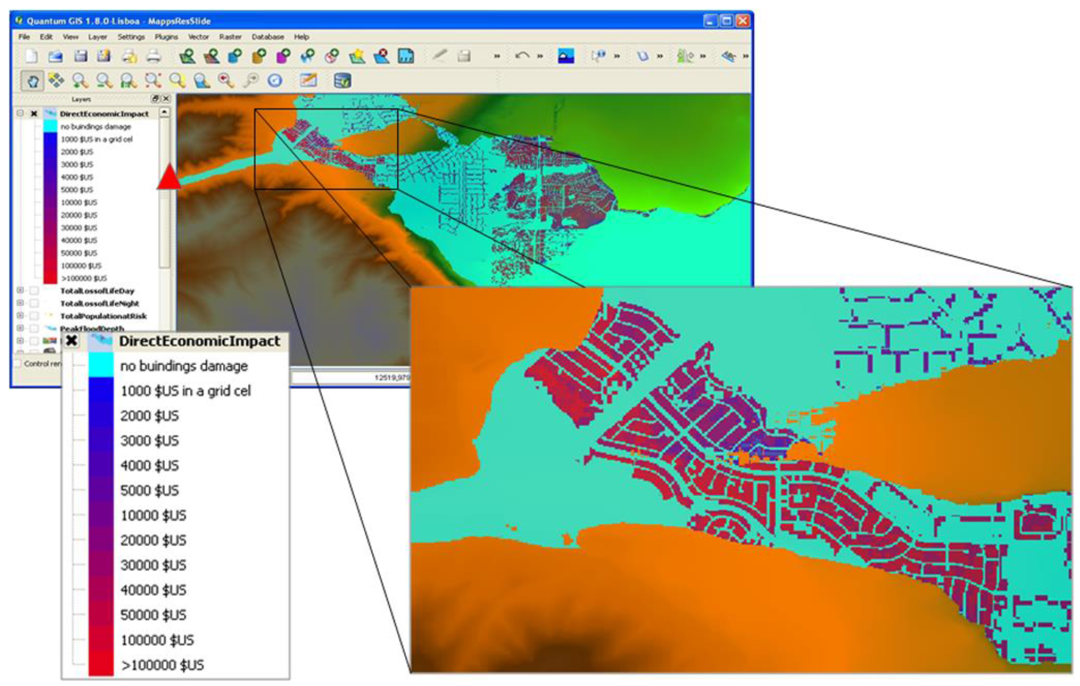
5.3. A (Free and Open-Source) FOSS GIS Risk Analysis Approach

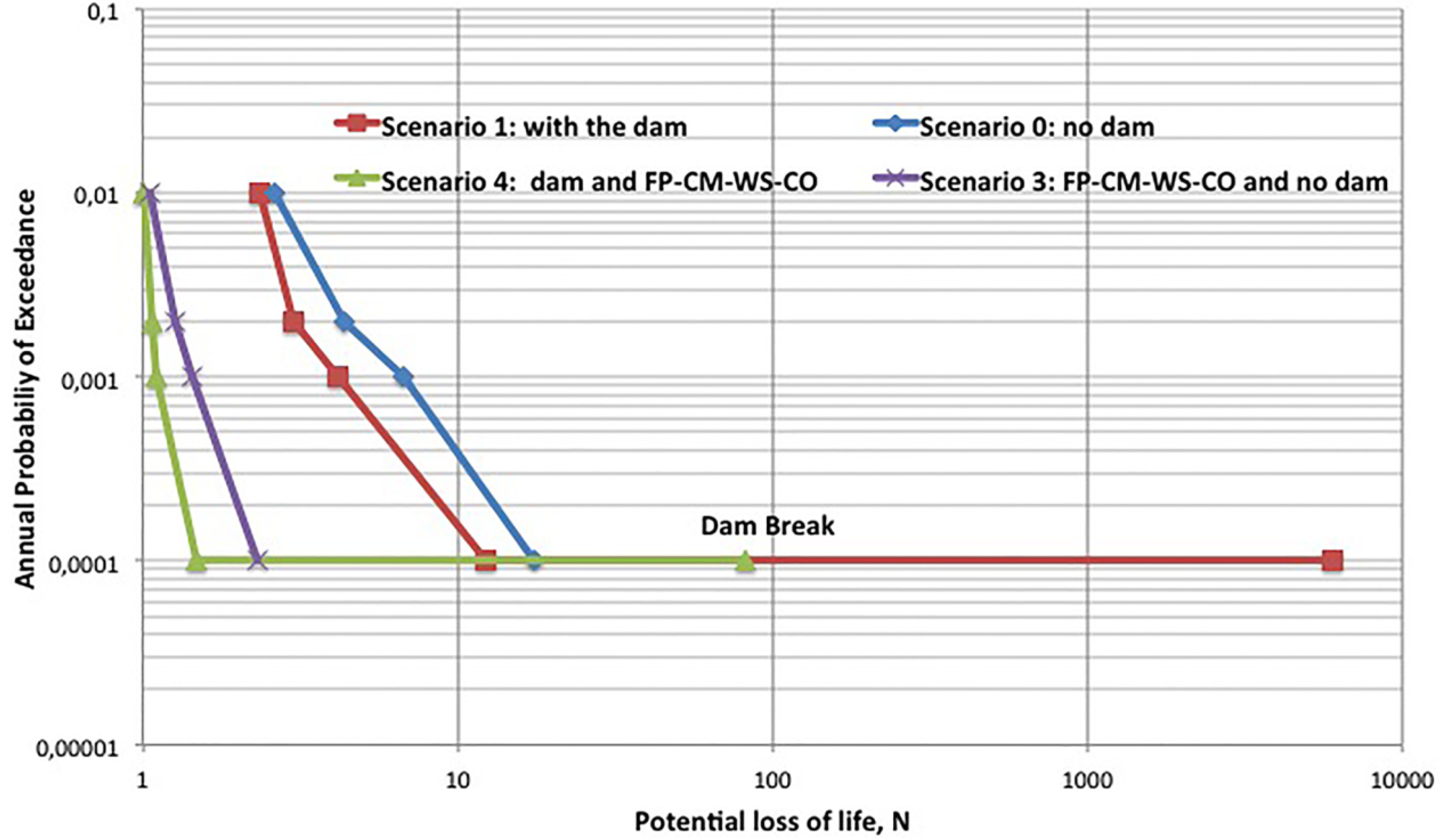
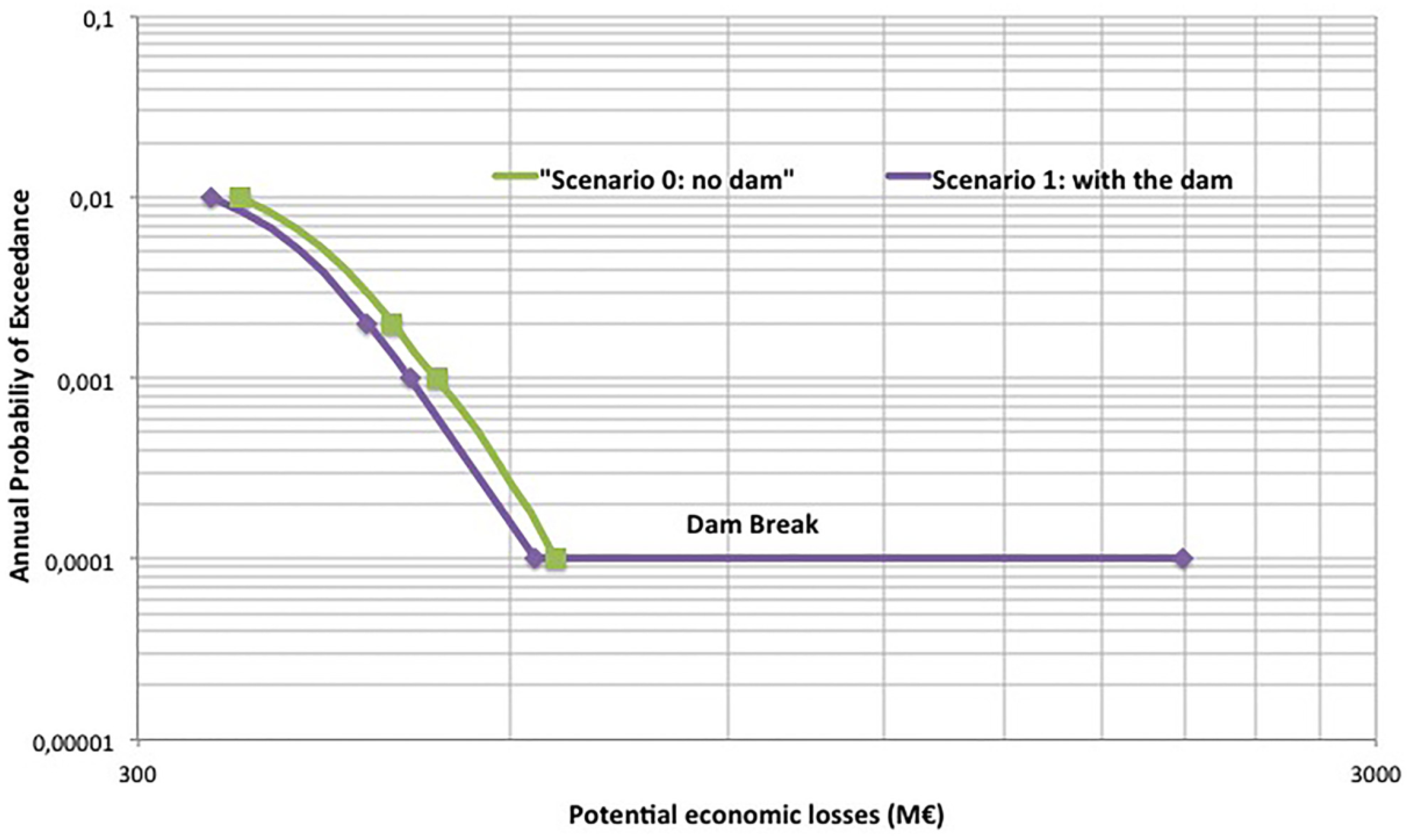
5.4. Outcomes of Flood Risk Analysis and Impact of Different Risk Reduction Measurements to Help Stakeholders in Their Compliance with the Floods Directive (2007/60/EC)

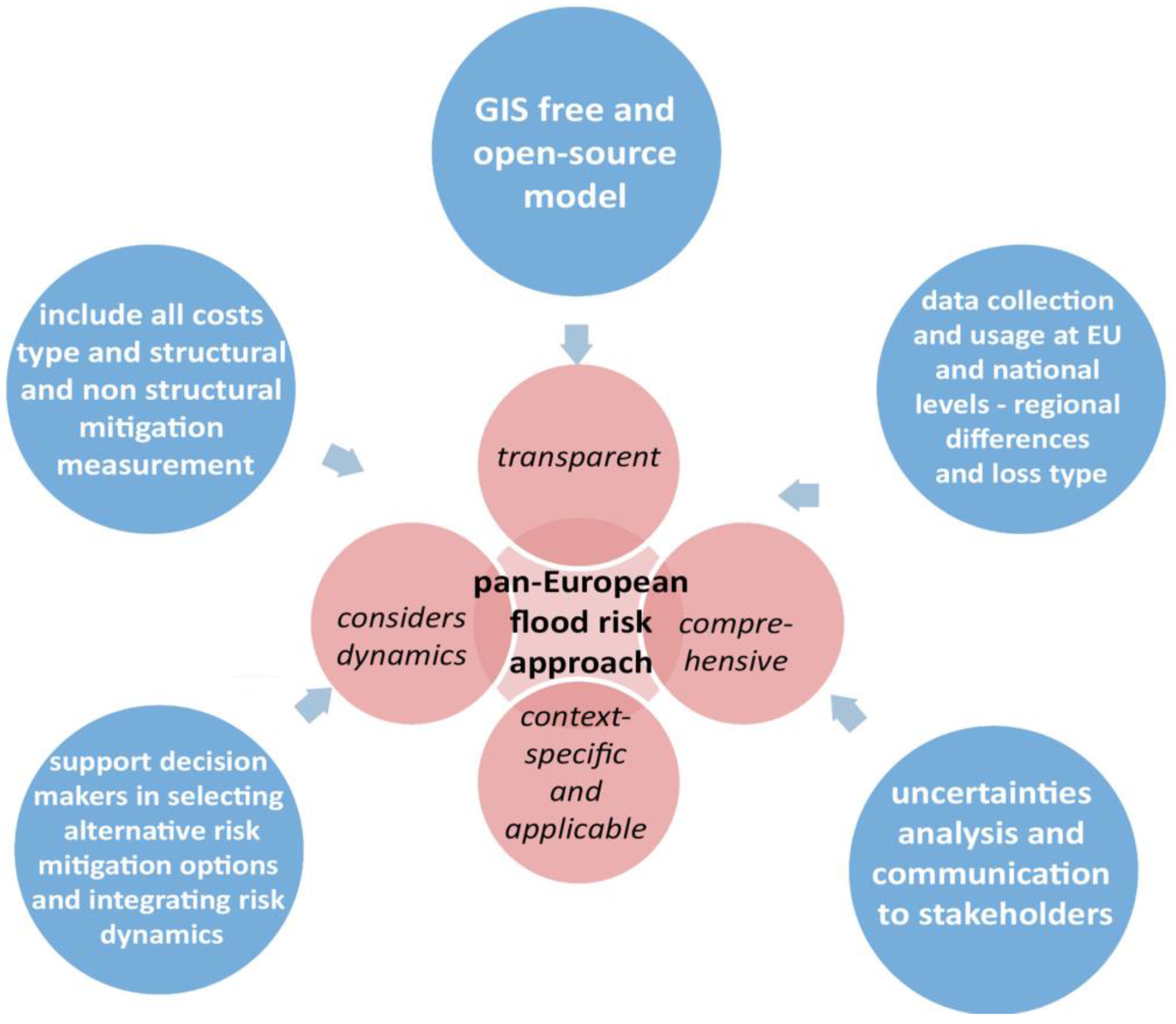
6. Conclusions and Further Research

- Currently, the understanding of the flood risk analysis process and its use in terms of flood risk assessment usually leads to highly uncertain results. Hence, we recommend following the new EU FRM approach that outlines the importance of identifying sources of uncertainties, of reducing the uncertainties effectively, and documenting those that remain.
- Increased effort should be devoted to integrate uncertainties in support decision-making tools in order to allow decision-makers and stakeholders to make more informed and better decisions.
- Currently, sensitivity and uncertainty analyses, as well as validations are rarely carried out. One of the major sources of uncertainty concerns data sources; a framework for supporting data collection at the European level, while ensuring minimum data quality standards, would facilitate the development and consistency of European and national databases. In this way, improved data is expected to lead to a better understanding of the processes causing damages and costs and, hence, to validation and ex ante cost assessment methods for the different cost categories. Damage data also need to be differentiated according to different loss types and regional differences. This could increase the understanding of risk analysis processes to model them appropriately.
- In this context, an improvement of models and tools is needed in terms of increasing the transparency and comprehensiveness of methods. A GIS FOSS model approach promotes learning and generates transparent knowledge through a process of guided discovery regarding spatio-temporal flood risk analysis.
- Due to limited budgets and increasing risks, these models should also include all relevant types of costs, i.e., direct costs, costs due to business interruption, indirect costs, non-market/intangible costs as well as structural and nonstructural mitigation measures. These models aim to support decision makers in selecting alternative risk mitigation options (e.g., cost-benefit analysis) by communicating and providing them with information to prioritize risk reduction measures and integrating uncertainties and dynamics of risk, due to climate and socio-economic change, into their decision making process.
Acknowledgments
Author Contributions
Conflicts of Interest
References
- Munich Re. Topics Geo Annual review: Natural Catastrophes 2005. Available online: http://www.preventionweb.net/files/1609_topics2005.pdf (accessed on day 6 April 2011).
- Meehl, G.A.; Tebaldi, C. More intense, more frequent, and longer last in heat waves in the 21st century. Science 2004, 305, 994–997. [Google Scholar] [CrossRef] [PubMed]
- Gao, X.J.; Giorgi, F. Increased aridity in the Mediterranean region under greenhouse gas forcing estimated from high resolution simulations with a regional climate model. Glob. Planet. Chang. 2008, 62, 195–209. [Google Scholar] [CrossRef]
- Adamowski, K.; Prokoph, A.; Adamowski, J. Development of a new method of wavelet aided trend detection and estimation. Hydrol. Process. 2009, 23, 2686–2696. [Google Scholar] [CrossRef]
- Adamowski, J.; Adamowski, K.; Bougadis, J. Influence of trend on short duration design storms. Water Resour. Manag. 2010, 24, 401–413. [Google Scholar] [CrossRef]
- Adamowski, K.; Prokoph, A.; Adamowski, J. Influence of the 11 year solar cycle on annual streamflow maxima in Canada. J. Hydrol. 2012, 442–443, 55–62. [Google Scholar]
- Nalley, D.; Adamowski, J.; Khalil, B. Using discrete wavelet transforms to analyze trends in stream flow and precipitation in Quebec and Ontario (1954–2008). J. Hydrol. 2012, 475, 204–228. [Google Scholar] [CrossRef]
- Nalley, D.; Adamowski, J.; Khalil, B.; Ozga-Zielinski, B. Trend detection in surface air temperature in Ontario and Quebec, Canada during 1967–2006 using the discrete wavelet transform. J. Atmos. Res. 2013, 132–133, 375–398. [Google Scholar] [CrossRef]
- Campisi, S.; Adamowski, J.; Oron, G. Forecasting urban water demand via wavelet-denoising and neural network models. Case study: City of Syracuse, Italy. Water Resour.Manag. 2012, 26, 3539–3558. [Google Scholar] [CrossRef]
- Araghi, A.; Adamowski, J.; Nalley, D.; Malard, J. Using wavelet transforms to estimate surface temperature trends and dominant periodicities in Iran based on gridded reanalysis data. J. Atmos. Res. 2015, 11, 52–72. [Google Scholar] [CrossRef]
- Haidary, A.; Amiri, B.J.; Adamowski, J.; Fohrer, N.; Nakane, K. Assessing the impacts of four land use types on the water quality of wetlands in Japan. Water Resour. Manag. 2013, 27, 2217–2229. [Google Scholar] [CrossRef]
- Pingale, S.; Khare, D.; Jat, M.; Adamowski, J. Spatial and temporal trends of mean and extreme rainfall and temperature for the 33 urban centres of the arid and semi-arid state of Rajasthan, India. J. Atmos. Res. 2014, 138, 73–90. [Google Scholar] [CrossRef]
- Halbe, J.; Pahl-Wostl, C.; Sendzimir, J.; Adamowski, J. Towards adaptive and integrated management paradigms to meet the challenges of water governance. Water Sci. Technol. 2013, 67, 2651–2660. [Google Scholar] [CrossRef] [PubMed]
- Straith, D.; Adamowski, J.; Reilly, K. Exploring the attributes, strategies and contextual knowledge of champions of change in the Canadian water sector. Can. Water Resour. J. 2014, 393, 255–269. [Google Scholar] [CrossRef]
- Inam, A.; Adamowski, J.; Halbe, J.; Prasher, S. Using causal loop diagrams for the initialization of stakeholder engagement in soil salinity management in agricultural watersheds in developing countries: A case study in the Rechna Doab watershed, Pakistan. J. Environ. Manag. 2015, 152, 251–267. [Google Scholar] [CrossRef] [PubMed]
- Butler, C.; Adamowski, J. Empowering marginalized communities in water resources management: Addressing inequitable practices in Participatory Model Building. J. Environ. Manag. 2015, 153, 153–162. [Google Scholar] [CrossRef] [PubMed]
- European Parliament and the Council of the European Union. Directive2007/60/EC on the Assessment and Management of Floodrisks; European Commission: Brussels, Belgium, 2007. [Google Scholar]
- Kreibich, H.; van den Bergh, J.C.J.M.; Bouwer, L.M.; Bubeck, P.; Ciavola, P.; Green, C.; Hallegatte, S.; Logar, I.; Meyer, V.; Schwarze, R.; et al. Costing natural hazards. Nat. Clim. Chang. 2014, 4, 303–306. [Google Scholar] [CrossRef]
- Krysanova, V.; Buiteveld, H.; Haase, D.; Hattermann, F.F.; van Niekerk, K.; Roest, K.; Martínez-Santos, P.; Schluter, M. Practices and Lessons Learned in Coping with Climatic Hazardsat the River-Basin Scale: Floods and Droughts. Available online: http://www.ecologyandsociety.org/vol13/iss2/art32/ (accessed on day 19 January 2009).
- Apel, H.; Aronica, G.T.; Kreibich, H.; Thieken, A.H. Flood risk analyses—How detailed do we need to be? Nat. Hazards 2009, 49, 79–98. [Google Scholar] [CrossRef]
- Commission Internationale des Grands Barrage. Risk Assessment in Dam Safety Management: A Reconnaissance of Benefits, Methods and Current Applications; Commission Internationale des Grands Barrage: Paris, France, 2005; p. 276. [Google Scholar]
- Klijn, F. Flood Risk Assessment and Flood Risk Management. An Introduction and Guidance Based on Experiences and Findings of FLOODsite; FLOODsite Project: Delft, the Netherland, 2009. [Google Scholar]
- Meyer, V.; Becker, N.; Markantonis, V.; Schwarze, R.; van den Bergh, J.C.J.M.; Bouwer, L.M.; Bubeck, P.; Ciavola, P.; Genovese, E.; Green, C.; et al. Review article: Assessing the costs of natural hazards-State of the art and knowledge gaps. Nat. Hazards Earth Syst. Sci. 2013, 13, 1351–1373. [Google Scholar] [CrossRef]
- Samuels, P.; Gouldby, B. Language of Risk—Project Definitions (Second Edition); FLOODsite Project: Delft, the Netherland, 2009. [Google Scholar]
- Klijn, F.; Mens, M.J.P.; Asselman, N.E.M. Flood risk management for an uncertain future: Robustness and economic efficiency perspectives compared for the Meuse River (Netherlands). Mitig. Adapt. Strateg. Glob. Chang. 2015, 6, 1011–1026. [Google Scholar] [CrossRef]
- Jongman, B.; Kreibich, H.; Apel, H.; Barredo, J.I.; Bates, P.D.; Feyen, L.; Gericke, A.; Neal, J.; Aerts, J.C.J.H.; Ward, P.J. Comparative flood damage model assessment: Towards a European approach. Nat. Hazards Earth Syst. Sci. 2012, 12, 3733–3752. [Google Scholar] [CrossRef] [Green Version]
- Albano, R.; Sole, A.; Adamowski, J. READY: A web-based geographical information system for enhanced flood resilience through raising awareness in citizens. Nat. Hazards Earth Syst. Sci. 2015, 15, 1645–1658. [Google Scholar] [CrossRef]
- Merz, B.; Kreibich, H.; Schwarze, R.; Thieken, A. Review article “Assessment of economic flood damage”. Nat. Hazards Earth Syst. Sci. 2010, 10, 1697–1724. [Google Scholar] [CrossRef]
- Green, C.; Viavattene, C.; Thompson, P. Guidance for Assessing Flood Losses—CONHAZ Report. Available online: http://www.mdx.ac.uk/__data/assets/pdf_file/0006/58794/floodsWP_FINALREPORTsept11.pdf (accessed on 9 September 2015).
- de Moel, H.; Asselman, N.E.M.; Aerts, J.C.J.H. Uncertainty and sensitivity analysis of coastal flood damage estimates in the west of the Netherlands. Nat. Hazards Earth Syst. Sci. 2012, 12, 1045–1058. [Google Scholar] [CrossRef]
- Smith, D.I. Actual and potential flood damage: A case study for urban Lismore, NSW, Australia. Appl. Geogr. 1981, 1, 31–39. [Google Scholar] [CrossRef]
- Albano, R.; Sole, A.; Adamowski, J.; Mancusi, L. A GIS-based model to estimate flood consequences and the degree of accessibility and operability of strategic emergency response structures in urban areas. Nat. Hazards Earth Syst. Sci. 2014, 14, 2847–2865. [Google Scholar] [CrossRef]
- Escuder-Bueno, I.; Castillo-Rodríguez, J.T.; Zechner, S.; Jöbstl, C.; Perales-Momparler, S.; Petaccia, G. A quantitative flood risk analysis methodology for urban areas with integration of social research data. Nat. Hazards Earth Syst. Sci. 2012, 12, 2843–2863. [Google Scholar] [CrossRef]
- World Bank. Understanding Risk in An Evolving World—Emerging Best Practices in Natural Disaster Risk Assessment; World Bank: Columbia, DC, USA, 2014. [Google Scholar]
- Jonkman, S.N.; Kok, M.; Vrijling, J.K. Flood risk assessment in the Netherlands: A case study for dike ring South Holland. Risk Anal. 2008, 28, 1357–1374. [Google Scholar] [CrossRef] [PubMed]
- Handmer, J. The chimera of precision: Inherent uncertainties in disaster loss assessment. Aust. J. Emerg. Manag. 2013, 18, 88–97. [Google Scholar]
- Heuvelink, G.B.M. Error Propagation in Environmental Modelling with GIS; CRC Press: Boca Raton, FL, USA, 1998; p. 146. [Google Scholar]
- de Moel, H.; Aerts, J.C.J.H. Effect of uncertainty in land use, damage models and inundation depth on flood damage estimates. Nat. Hazard 2011, 58, 407–425. [Google Scholar] [CrossRef]
- Amicarelli, A.; Albano, R.; Mirauda, D.; Agate, G.; Sole, A.; Guandalini, R. A Smoothed Particle Hydrodynamics model for 3D solid body transport in free surface flows. Comput. Fluids 2015, 116, 205–228. [Google Scholar] [CrossRef]
- Beven, K.J.; Binley, A. The future of distributed models: Model calibration and uncertainty prediction. Hydrol. Process. 1992, 6, 279–298. [Google Scholar] [CrossRef]
- Poeter, E.P.; Hill, M.C. UCODE, a computer code for universal inverse modeling. Comput. Geosci. 1999, 25, 457–462. [Google Scholar] [CrossRef]
- Federal Emergency Management Agency. HAZUS-MH MR4 Flood Model Technical Manual, 2009; Federal Emergency Management Agency: Washington, DC, USA, 2009.
- Kok, M.; Huizinga, H.J.; Vrouwenvelder, A.C.W.M.; Barendregt, A. Standard Method 2004 Damage and Casualties Caused by Flooding; Road and Hydraulic Engineering Institute: Delft, the Netherlands, 2005. [Google Scholar]
- International Commission for the Protection of the Rhine (ICPR). Action Plan on Flood Defence; International Commission for the Protection of the Rhine: Koblenz, Germany, 1998. [Google Scholar]
- Vanneuville, W.; Gamanya, R.K.; de Rouck, K.; Maeghe, K.; de Maeyer, P.; Mostaert, F. Development of a Flood Risk Model and applications in the management of hydrographical catchments. In Proceedings of the Cartographic Cutting-Edge Technology for Natural Hazard Management, Dresden, Germany, 20–22 October 2004.
- Klijn, F.; Baan, P.; deBruijn, K.M.; Kwadijk, J. Overstromingsrisico’s in Nederland in een veranderend klimaat: Verwachtingen, Schattingenen Berekeningen voor Het Project Nederland Later; Delft Hydraulics: delft, the Netherlands, 2007. [Google Scholar]
- Huizinga, H.J. Flood Damage Functions for EU Member States: Flood Risk Mapping Using Corine Land Cover Datasets; European Commission: Brussels, Belgium, 2010. [Google Scholar]
- Penning-Rowsell, E.; Viavattene, C.; Pardoe, J.; Chatterton, J.; Parker, D.; Morris, J. The Benefits of Flood and Coastal Risk Management: A Handbook of Assessment Techniques; Flood Hazard Research Centre: London, UK, 2010. [Google Scholar]
- Thieken, A.H.; Olschewski, A.; Kreibich, H.; Kobsch, S.; Merz, B. Development and evaluation of FLEMOps—A new flood loss estimation model for the private sector. In Flood Recovery, Innovation and Response; Proverbs, D., Brebbia, C.A., Penning-Rowsell, E., Eds.; WIT Press: Ashurst, UK, 2008; pp. 315–324. [Google Scholar]
- De Bono, A.; Chatenoux, B. A Global Exposure Model for GAR 2015, UNEP/Grid-Geneva; UNISDR: Geneva, Switzerland, 2015. [Google Scholar]
- Di Leo, M.; Manfreda, S.; Fiorentino, M. An automated procedure for the detection of flood Prone areas: r.hazard.flood. Geomat. Workb. 2011, 10, 83–89. [Google Scholar]
- Cannata, M.; Marzocchi, R. Two-dimensional dam break flooding simulation: A GIS embedded approach. Nat. Hazards 2012, 61, 1143–1159. [Google Scholar] [CrossRef]
- Rojas, R.; Julien, P.Y.; Johson, B. A 2-Dimensional Rainfall-Runoff and Sediment Model. Available online: http://www.engr.colostate.edu/~pierre/ce_old/Projects/CASC2D-SED%20Web%20site%20082506/Download_files/CASC2D-SED-Reference-Manual.pdf (Accessed on 22 January 2004).
- Vieux, B.E.; Bralts, V.F.; Segerlind, L.J.; Wallace, R.B. Finite element watershed modeling:One-dimensional elements. J. Water Resour. Plan.Manag. 1990, 116, 803–819. [Google Scholar] [CrossRef]
- Mitasova, H.; Thaxton, C.; Hofierka, J.; McLaughlin, R.; Moore, A.; Mitas, L. Path sampling method for modeling overland water flow, sediment transport and short term terrain evolution in Open Source GIS. In Proceedings of the XVth International Conference on Computational Methods in Water Resources (CMWR XV), Chapel Hill, NC, USA, 13–17 June 2004; pp. 1479–1490.
- Cannata, M.; Brovelli, A. An Overview of HydroFOSS, a Novel GIS Embedded Hydrological Model. Available online: http://meetings.copernicus.org/www.cosis.net/abstracts/EGU06/04835/EGU06-J-04835.pdf (accessed on day 12 January 2006).
- Jonkman, S.N.; Jongejan, R.; Maaskant, B. The use of individual and societal risk criteria within the Dutch flood safety policy—Nationwide estimates of societal risk and policy applications. Risk Anal. 2011, 31, 282–300. [Google Scholar] [CrossRef] [PubMed]
- Seda-Sanabria, Y.; Matheu, E.E.; McPherson, T.N. Computational challenges in consequence estimation for risk assessment. In Proceedings of the ICOLD—12th International Benchmark Workshop on Numerical Analysis of Dams, Graz, Austria, 2–4 October 2013.
- Castillo-Rodríguez, J.T.; Escuder-Bueno, I.; Altarejos-García, L.; Serrano-Lombillo, A. The value of integrating information from multiple hazards for flood risk analysis and management. Nat. Hazards Earth Syst. Sci. 2014, 14, 379–400. [Google Scholar] [CrossRef]
© 2015 by the authors; licensee MDPI, Basel, Switzerland. This article is an open access article distributed under the terms and conditions of the Creative Commons Attribution license (http://creativecommons.org/licenses/by/4.0/).
Share and Cite
Albano, R.; Mancusi, L.; Sole, A.; Adamowski, J. Collaborative Strategies for Sustainable EU Flood Risk Management: FOSS and Geospatial Tools—Challenges and Opportunities for Operative Risk Analysis. ISPRS Int. J. Geo-Inf. 2015, 4, 2704-2727. https://doi.org/10.3390/ijgi4042704
Albano R, Mancusi L, Sole A, Adamowski J. Collaborative Strategies for Sustainable EU Flood Risk Management: FOSS and Geospatial Tools—Challenges and Opportunities for Operative Risk Analysis. ISPRS International Journal of Geo-Information. 2015; 4(4):2704-2727. https://doi.org/10.3390/ijgi4042704
Chicago/Turabian StyleAlbano, Raffaele, Leonardo Mancusi, Aurelia Sole, and Jan Adamowski. 2015. "Collaborative Strategies for Sustainable EU Flood Risk Management: FOSS and Geospatial Tools—Challenges and Opportunities for Operative Risk Analysis" ISPRS International Journal of Geo-Information 4, no. 4: 2704-2727. https://doi.org/10.3390/ijgi4042704
APA StyleAlbano, R., Mancusi, L., Sole, A., & Adamowski, J. (2015). Collaborative Strategies for Sustainable EU Flood Risk Management: FOSS and Geospatial Tools—Challenges and Opportunities for Operative Risk Analysis. ISPRS International Journal of Geo-Information, 4(4), 2704-2727. https://doi.org/10.3390/ijgi4042704