Does the Visibility of Greenery Increase Perceived Safety in Urban Areas? Evidence from the Place Pulse 1.0 Dataset
Abstract
:1. Introduction
2. Data
2.1. Place Pulse 1.0 Dataset
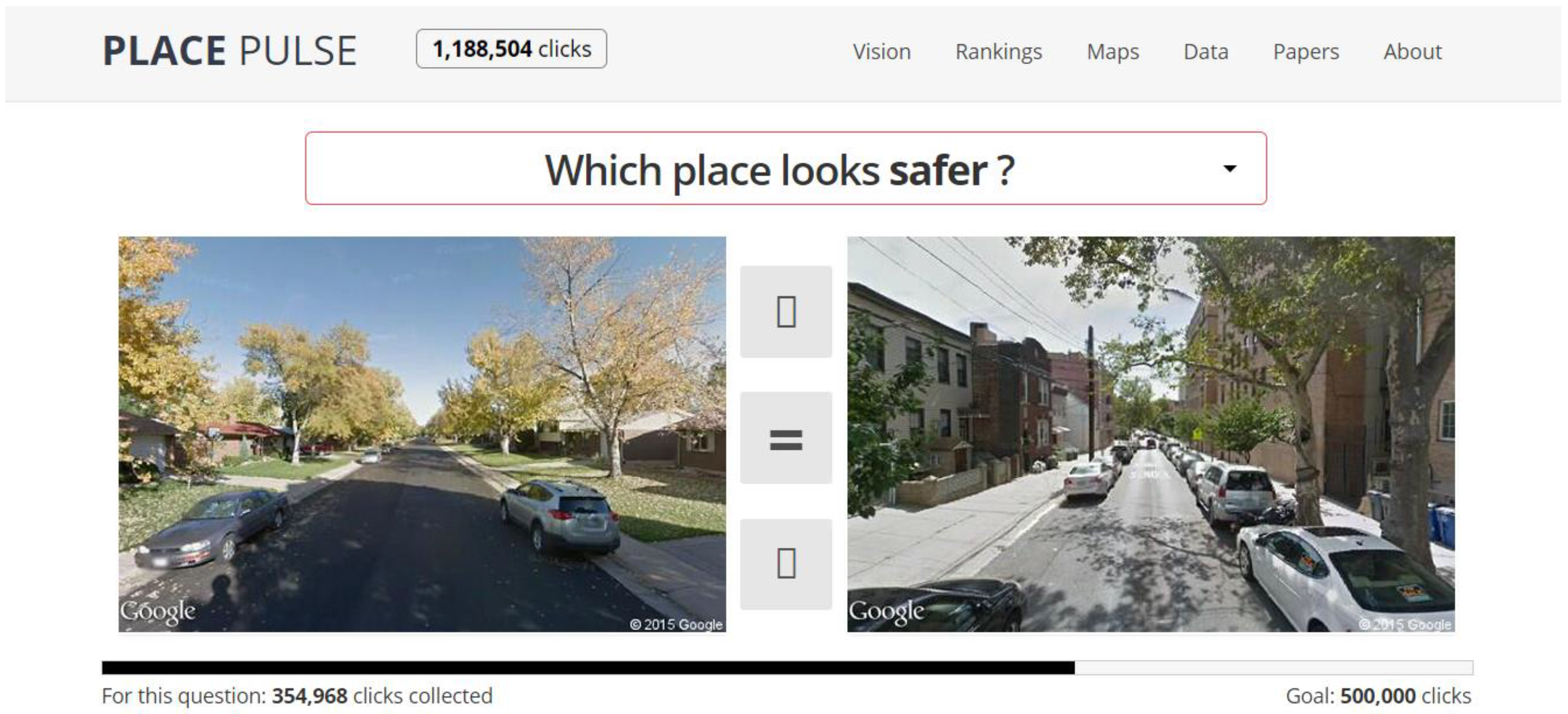
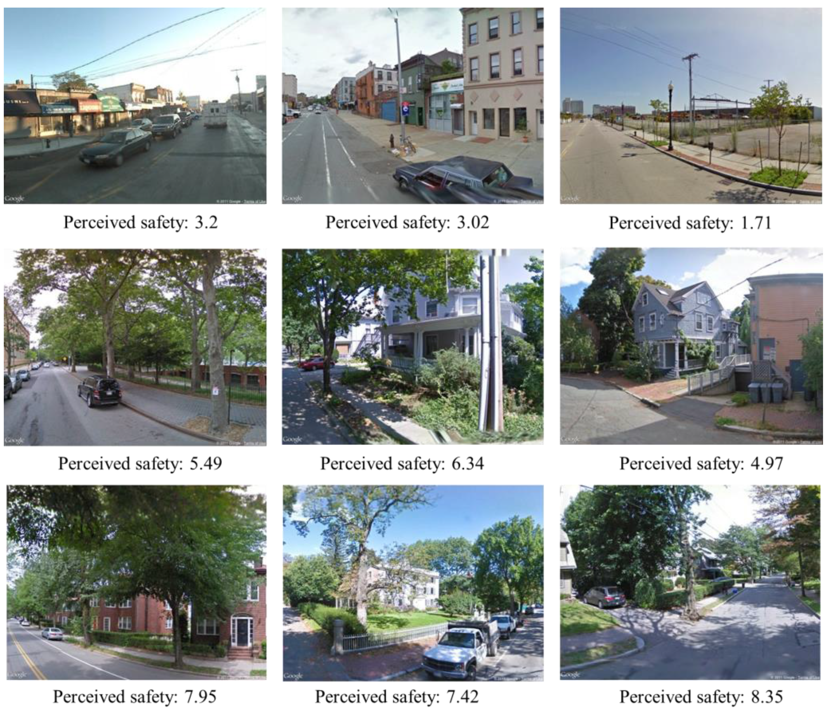
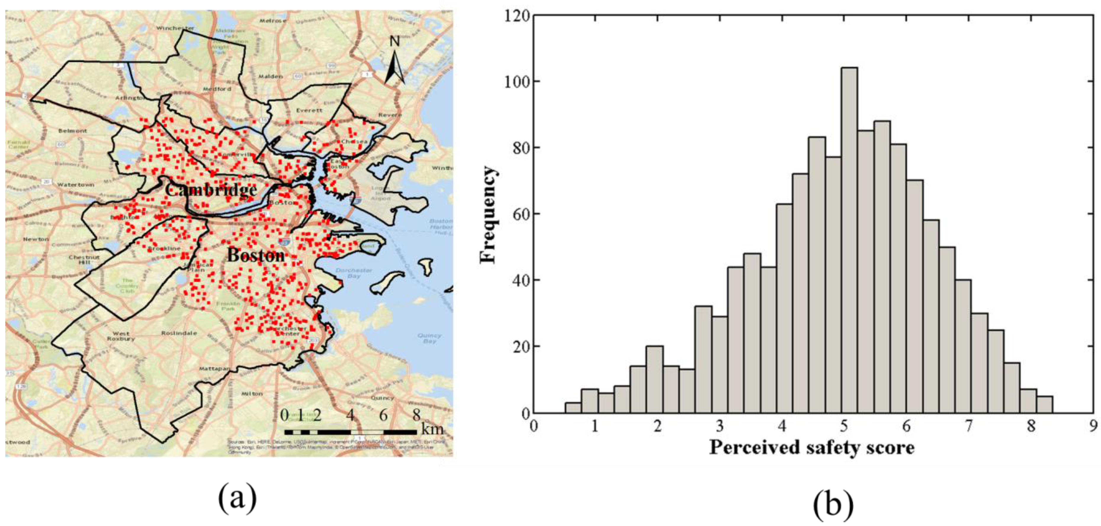
2.2. Land Use Map
| Land Use Type | Descriptions |
|---|---|
| Multifamily residential land | Duplexes (usually with two front doors, two entrance pathways and sometimes two driveways), apartment buildings, condominium complexes, including buildings and maintained lawns. In this study, it also includes medium-density residential land. |
| High-density residential land | Housing on smaller than 1/4 acre lots. |
| Transportation land | Airports (including landing strips, hangars, parking areas and related facilities), railroads and rail stations and divided highways (related facilities would include rest areas, highway maintenance areas, storage areas and on/off ramps). |
| Urban public/institutional land | Lands comprising schools, churches, colleges, hospitals, museums, prisons, town halls or court houses, police and fire stations, including parking lots, dormitories and university housing; also may include public open green spaces, like town commons. |
| Commercial land | Malls, shopping centers and larger strip commercial areas, plus neighborhood stores and medical offices (not hospitals). |
| Industrial land | Light and heavy industry, including buildings, equipment and parking areas. |
| Open land | Vacant land, idle agriculture, rock outcrops and barren areas. Vacant land is not maintained for any evident purpose, and it does not support large plant growth. In this study, it also includes participation recreation, marina, cemetery, transitional land. |
3. Methodology
3.1. Extraction of Vegetation Information from GSV Images
3.1.1. Vegetation Classification from GSV Images
| Comment: G, R and B are three bands in segmented images |
| Comment: Vegetation is the vegetation extraction result |
| ExG = 2 × G – R – B |
| Threshold = OTSU(ExG) |
| for each pixel [i, j] in ExG: |
| if ExG [i, j] > Threshold: |
| Classify Vegetation [i, j] as green vegetation |
| Mask out pixels with values in green, red, blue band higher than 0.6 in the Vegetation image |
3.1.2. Vertical Distribution of Greenery
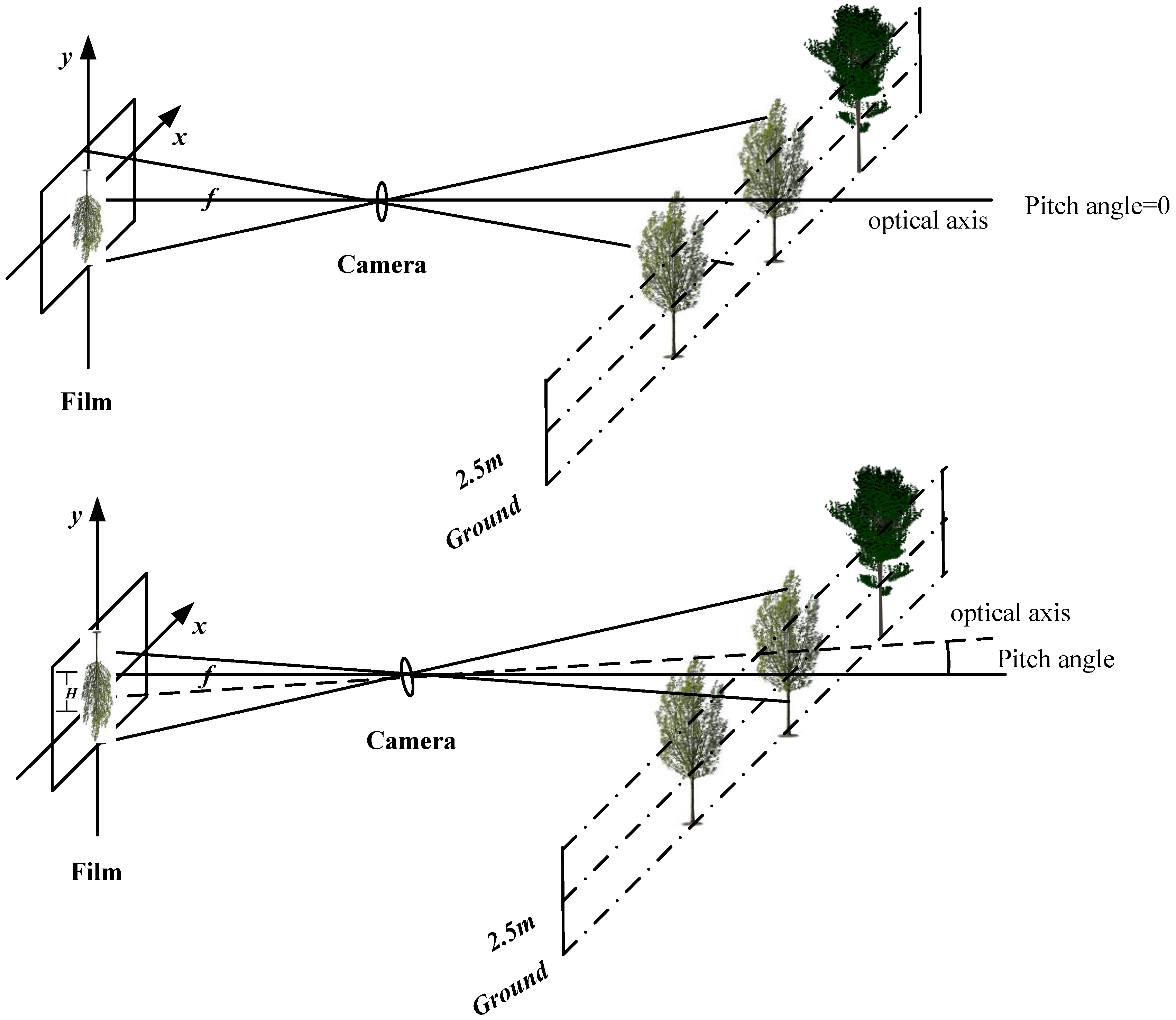
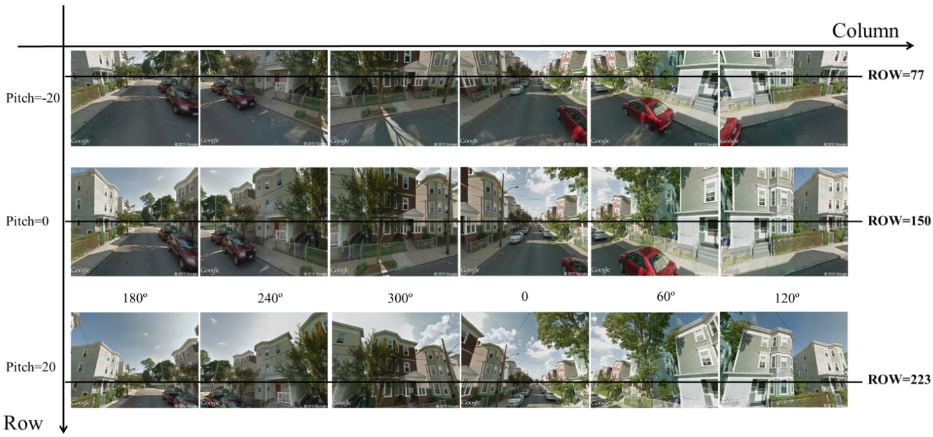
3.2. Image Quality of Geo-Tagged Imagery
3.2.1. Brightness
3.2.2. Contrast
3.3. Variables’ Preparation and Regression Analysis
- High density residential land: x1 = 1, x2 = x3 = x4 = x5 = x6 = 0
- Urban public/institutional land: x1 = 0, x2 = 1, x3 = x4 = x5 = x6 = 0
- Transportation: x1 = x2 = 0, x3 =1, x4 = x5 = x6 = 0
- Commercial land: x1 = x2 = x3 = 0, x4 = 1, x5 = x6 = 0
- Industrial land: x1 = x2 = x3 = x4, x5 = 1, x6 = 0
- Open land: x1 = x2 = x3 = x4 = x5 = 0, x6 = 1
4. Results
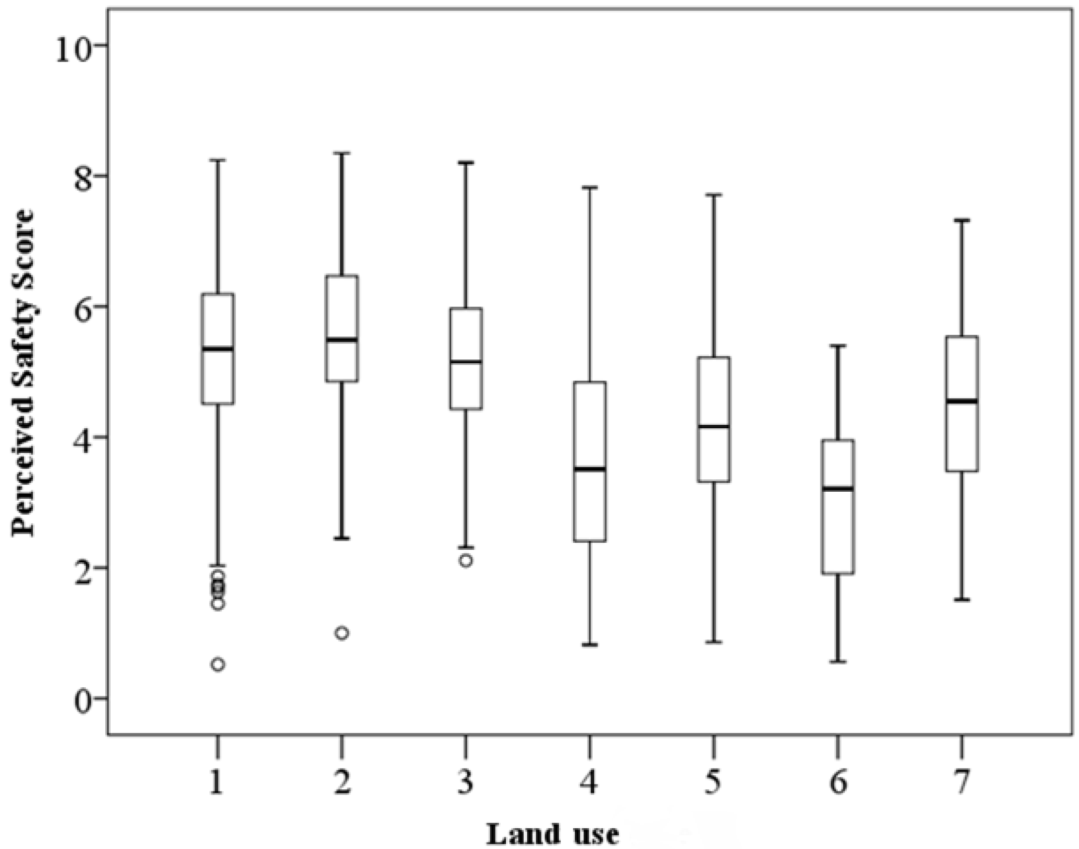
| Variables | Pearson’s Correlation | Sig (2-tailed) | N |
|---|---|---|---|
| Percentage of vegetation | 0.388** | 0.000 | 1217 |
| Percentage of vegetation above horizon | 0.358** | 0.000 | |
| Percentage of vegetation below horizon | 0.296** | 0.000 | |
| Brightness | −0.188** | 0.000 | |
| Contrast | 0.304** | 0.000 |
| Multiple Linear Regression | |||||
|---|---|---|---|---|---|
| Standardized Coefficients | t-Value | p-Value | VIF | ||
| Vegetation | Percentage of vegetation above the horizon | 0.194** | 6.603 | 0.000 | 1.56 |
| Percentage of vegetation below the horizon | 0.102** | 3.773 | 0.000 | 1.32 | |
| Image quality | Contrast | 0.208** | 7.950 | 0.000 | 1.41 |
| Brightness | −0.111** | −3.986 | 0.000 | 1.25 | |
| Land use types | High-density residential land | 0.029 | 1.173 | 0.241 | 1.11 |
| Urban public/institutional land | −0.051* | −2.056 | 0.040 | 1.11 | |
| Transportation land | −0.132** | −5.396 | 0.000 | 1.10 | |
| Commercial land | −0.181** | −7.130 | 0.000 | 1.18 | |
| Industrial land | −0.284** | −11.512 | 0.000 | 1.10 | |
| Open land | −0.099** | −4.118 | 0.000 | 1.05 | |
| R2 | 0.337 | ||||
| F-statistic | 61.178 | ||||
| Adjusted R2 | 0.331 | ||||
| Multicollinearity condition number | 21.863 | ||||
| Dependent Variable: Perceived Safety | ||||||||
|---|---|---|---|---|---|---|---|---|
| Independent Variables | Multifamily Residential | High-Density Residential | Urban Public/ Institutional | Transportation | Commercial | Industrial | Open Land | |
| Vegetation above horizon | 0.180 ** | 0.247 * | 0.320 ** | 0.115 | 0.258 ** | −0.013 | 0.451 * | |
| Vegetation below horizon | 0.164 ** | 0.123 | 0.186 * | −0.054 | 0.015 | 0.159 | −0.144 | |
| Contrast | 0.165 ** | 0.328 ** | 0.047 | 0.476 ** | 0.259 ** | 0.408 ** | 0.197 | |
| Brightness | −0.075 | −0.052 | −0.037 | −0.376 ** | −0.237 ** | −0.312 ** | −0.082 | |
| F-statistic | 21.239 | 9.310 | 8.680 | 6.984 | 12.39 | 6.362 | 4.646 | |
| R2 | 0.128 | 0.223 | 0.194 | 0.383 | 0.219 | 0.285 | 0.297 | |
| Adjust R2 | 0.122 | 0.199 | 0.172 | 0.328 | 0.201 | 0.240 | 0.233 | |
| Multicollinearity condition number | 20.296 | 23.724 | 20.773 | 24.494 | 22.160 | 19.372 | 28.852 | |
5. Discussions
6. Conclusions
Acknowledgments
Author Contributions
Conflicts of Interest
References
- Fernow, B.E. The Care of Trees in Lawn, Street and Park; Henry Holt and Company: New York, NY, USA, 1910. [Google Scholar]
- Schroeder, H.W.; Cannon, W.N., Jr. The esthetic contribution of trees to residential streets in Ohio towns. J. Arboric. 1983, 9, 237–243. [Google Scholar]
- Wolf, K.L. Business district streetscapes, trees, and consumer response. J. For. 2005, 103, 396–400. [Google Scholar]
- Maas, J.; Spreeuwenberg, P.; van Winsum-Westra, M.; Verheij, R.A.; de Vries, S.; Groenewegen, P.P. Is green space in the living environment associated with people’s feelings of social safety? Environ. Plan. A 2009, 41, 1763–1777. [Google Scholar] [CrossRef]
- Jansson, M.; Fors, H.; Lindgren, T.; Wiström, B. Perceived personal safety in relation to urban woodland vegetation—A review. Urban For. Urban Green. 2013, 12, 127–133. [Google Scholar] [CrossRef]
- Chivite-Matthews, N.; Maggs, P. Crime, Policing and Justice: The Experience of Older People. Findings from the British Crime Survey, England and Wales; Home Office Research, Development and Statistics Directorate: London, UK, 2002. [Google Scholar]
- Green, G.; Gilbertson, J.M.; Grimsley, M.F.J. Fear of crime and health in residential tower blocks: A case study in Liverpool UK. Eur. J. Public Health 2002, 12, 10–15. [Google Scholar] [CrossRef] [PubMed]
- Li, F.; Fisher, J.; Brownson, R.C.; Bosworth, M. Multilevel modeling of built environment characteristics related to neighbourhood walking activity in older adults. J. Epidemiol. Community Health 2005, 59, 558–564. [Google Scholar] [CrossRef] [PubMed]
- Strafford, M.; Chandola, T.; Marmot, M. Association between fear of crime and mental health and physical functioning. Am. J. Public Health 2007, 97, 2076–2081. [Google Scholar] [CrossRef] [PubMed]
- Jackson, J.; Stafford, M. Public health and fear of crime: A prospective cohort study. Br. J. Criminol. 2009, 49, 832–847. [Google Scholar] [CrossRef]
- Jorgensen, A.; Hitchmough, J.; Calvert, T. Woodland spaces and edges: Their impact on perception of safety and preference. Landsc. Urban Plan. 2002, 60, 135–150. [Google Scholar] [CrossRef]
- Kuo, F.E.; Sullivan, W.C. Environment and crime in the inner city: Does vegetation reduce crime? Environ. Behav. 2001, 33, 343–367. [Google Scholar] [CrossRef]
- Troy, A.; Grove, J.M.; O’Neil-Dunne, J. The relationship between tree canopy and crime rates across an urban-rural gradient in the greater Baltimore region. Landsc. Urban Plan. 2012, 106, 262–270. [Google Scholar] [CrossRef]
- Day, K.; Stump, C.; Carreon, D. Confrontation and loss of control: Masculinity and men’s fear in public space. J. Environ. Psychol. 2003, 23, 311–322. [Google Scholar] [CrossRef]
- Van der Wurff, A.; van Staalduinen, L.; Stringer, P. Fear of crime in residential environments: Testing a social psychological model. J. Soc. Psychol. 1989, 129, 141–160. [Google Scholar] [CrossRef]
- Farrall, S.; Bannister, J.; Ditton, J.; Gilchrist, E. Social psychology and the fear of crime: Re-examining a speculative model. Br. J. Criminol. 2000, 40, 399–413. [Google Scholar] [CrossRef]
- Fisher, B.S.; Nasar, J.L. Fear of crime in relation to three exterior site features prospect, refuge, and escape. Environ. Behav. 1992, 24, 35–65. [Google Scholar] [CrossRef]
- Nasar, J.; Fisher, B.; Grannis, M. Proximate physical cues to fear of crime. Landsc. Urban Plan. 1993, 26, 161–178. [Google Scholar] [CrossRef]
- Donovan, G.H.; Prestemon, J.P. The effect of trees on crime in Portland, OR. Environ. Behav. 2012, 44, 3–30. [Google Scholar] [CrossRef]
- Coutts, C. Greenway accessibility and physical-activity behavior. Environ. Plan. B: Plan. Des. 2008, 35, 552–563. [Google Scholar] [CrossRef]
- Lee, A.C.K.; Maheswaran, R. The health benefits of urban green spaces: A review of the evidence. J. Public Health 2011, 33, 212–222. [Google Scholar] [CrossRef] [PubMed]
- Kuo, F.E. The role of arboriculture in a healthy social ecology. J. Arboric. 2003, 29, 148–155. [Google Scholar]
- Jacobs, J. The Death and Life of Great American Cities; Random House: New York, NY, USA, 1961. [Google Scholar]
- Shaffer, G.S.; Anderson, L.M. Perceptions of the security and attractiveness of urban parking lots. J. Environ. Psychol. 1985, 5, 311–323. [Google Scholar] [CrossRef]
- Herzog, T.; Kutzli, H. Preference and perceived danger in field/forest settings. Environ. Behav. 2002, 34, 858–874. [Google Scholar] [CrossRef]
- Herzog, T.R.; Bryce, A.G. Mystery and preference in within-forest settings. Environ. Behav. 2007, 39, 779–796. [Google Scholar] [CrossRef]
- Kuo, F.E.; Sullivan, W.C. Aggression and violence in the inner city effects of environment via mental fatigue. Environ. Behav. 2001, 33, 543–571. [Google Scholar] [CrossRef]
- Roovers, P.; Dumont, B.; Gulinck, H.; Hermy, M. Recreationists’ perceived obstruction of field and shrub layer vegetation. Urban For. Urban Green. 2006, 4, 47–53. [Google Scholar] [CrossRef]
- Schroeder, H.W.; Anderson, L.M. Perception of personal safety in urban recreation sites. J. Leis. Res. 1984, 16, 178–194. [Google Scholar]
- Anselin, L.; Cohen, J.; Cook, D.; Gorr, W.; Tita, G. Spatial analyses of crime. Crim. Justice 2000, 4, 213–262. [Google Scholar]
- Wilcox, P.; Quisenberry, N.; Cabrera, D.T.; Jones, S. Busy places and broken windows? Toward defining the role of physical structure and process in community crime models. Sociol. Q. 2004, 45, 185–207. [Google Scholar]
- Salesses, P.; Schechtner, K.; Hidalgo, C.A. The collaborative image of the city: Mapping the inequality of urban perception. PloS one 2013, 8. [Google Scholar] [CrossRef] [PubMed]
- Park , J.; Newman, M.E.J. A network-based ranking system for US college football. J. Stat. Mech.: Theory Exp. 2005, 10. [Google Scholar] [CrossRef]
- MassGIS Data—Land Use (2005). Available online: http://www.mass.gov/anf/research-and-tech/it-serv-and-support/application-serv/office-of-geographic-information-massgis/datalayers/lus2005.html (accessed on 23 December 2014).
- Li, X.; Meng, Q.; Gu, X.; Jancso, T.; Yu, T.; Wang, K.; Mavromatis, S. A hybrid method combining pixel-based and object-oriented methods and its application in Hungary using Chinese HJ-1 satellite images. Int. J. Remote Sens. 2013, 34, 4655–4668. [Google Scholar] [CrossRef]
- Woebbecke, D.M.; Meyer, G.E.; von Bargen, K.; Mortensen, D.A. Shape features for identifying young weeds using image analysis. Trans. ASAE 1995, 38, 271–281. [Google Scholar] [CrossRef]
- Ribeiro, A.; Fernández-Quintanilla, C.; Barroso, J.; García-Alegre, M.C. Development of an image analysis system for estimation of weed. In Proceedings of the 5th European Conference on Precision Agriculture (5ECPA), Uppsala, Sweden; 2005; pp. 169–174. [Google Scholar]
- Otsu, N. A threshold selection method from gray-level histograms. Automatica 1975, 11, 23–27. [Google Scholar]
- Taylor, R.B.; Koons, B.A.; Kurtz, E.M.; Greene, J.R.; Perkins, D.D. Street blocks with more nonresidential land use have more physical deterioration: Evidence from Baltimore and Philadelphia. Urban Aff. Rev. 1995, 31, 120–136. [Google Scholar] [CrossRef]
- Sampson, R.J.; Raudenbush, S.W. Systematic social observation of public spaces: A new look at disorder in urban neighborhoods. Am. J. Sociol. 1999, 105, 603–65l. [Google Scholar] [CrossRef]
- Kelling , G.L.; Wilson, J.Q. Broken windows. Atl. Mon. 1982, 249, 29–38. [Google Scholar]
© 2015 by the authors; licensee MDPI, Basel, Switzerland. This article is an open access article distributed under the terms and conditions of the Creative Commons Attribution license (http://creativecommons.org/licenses/by/4.0/).
Share and Cite
Li, X.; Zhang, C.; Li, W. Does the Visibility of Greenery Increase Perceived Safety in Urban Areas? Evidence from the Place Pulse 1.0 Dataset. ISPRS Int. J. Geo-Inf. 2015, 4, 1166-1183. https://doi.org/10.3390/ijgi4031166
Li X, Zhang C, Li W. Does the Visibility of Greenery Increase Perceived Safety in Urban Areas? Evidence from the Place Pulse 1.0 Dataset. ISPRS International Journal of Geo-Information. 2015; 4(3):1166-1183. https://doi.org/10.3390/ijgi4031166
Chicago/Turabian StyleLi, Xiaojiang, Chuanrong Zhang, and Weidong Li. 2015. "Does the Visibility of Greenery Increase Perceived Safety in Urban Areas? Evidence from the Place Pulse 1.0 Dataset" ISPRS International Journal of Geo-Information 4, no. 3: 1166-1183. https://doi.org/10.3390/ijgi4031166
APA StyleLi, X., Zhang, C., & Li, W. (2015). Does the Visibility of Greenery Increase Perceived Safety in Urban Areas? Evidence from the Place Pulse 1.0 Dataset. ISPRS International Journal of Geo-Information, 4(3), 1166-1183. https://doi.org/10.3390/ijgi4031166


