1. Introduction
The concept of crowdsourcing, as described by Howe [
1,
2], emerged with a change in the way information is created, curated and distributed. These changes are attributed to the manifestation of the internet first widely known by O’Reilly’s [
3] description as Web 2.0. The concept of citizens as sensors captures how crowdsourcing can be directed toward collecting (sensing) information regarding the environment [
4]. Crowd sourced or citizen sensed information that includes its geographic location is described as volunteered geographic information (VGI) [
4,
5]. Citizens as sensors and VGI have been enabled by developments in spatial technologies occurring concurrently with the Web 2.0, and that includes online interactive geographic information systems (GIS), spatially enabled mobile computers, smart phones and other sensors, such as cameras. Collectively these spatial technologies have been described with terms that include the GeoWeb [
6,
7], Geospatial Web [
8,
9], Geospatial Web 2.0 [
10,
11,
12] and this journal issue, GeoWeb 2.0. The latter has been adopted herein as most succinct and also apt, acknowledging the significance of the intersection of spatial capabilities with the interactivity of the wider Web 2.0. Early authors on the GeoWeb 2.0 situate its origins partly within Web 2.0 [
6,
8,
13,
14], and literature describing related concepts and practices repeat this [
4,
7,
15,
16]. Any discussion of the significance of crowdsourcing, citizens acting as sensors and VGI, needs then to be cognizant of the significance of the wider Web 2.0 and GeoWeb 2.0 contexts.
Academics [
17,
18] and industry leaders [
19] describe the Web 2.0, and the wider technological developments it is part of, as akin to a revolution in human communication, and one that is only just underway. Major positive and negative societal impacts have been attributed to it. The former include the creation of new economic opportunities [
20,
21], improved disaster responses [
22], and the democratisation of information [
23]. Negative impacts include disruptions to government, civil unrest and the demise of extant industries and social capital [
17,
19]. Macnamara’s [
24] description of how crowdsourced maps of North Korea can stir international political tensions, highlights how the intersection of spatial and interactive internet capabilities provided by the GeoWeb 2.0, enabling the inclusion of “where”, adds to the potential of Web 2.0. Given these observed impacts, use of GeoWeb 2.0 capabilities enlisting crowdsourcing, VGI and citizens as sensors, has similar potential for transformation or disruption. Hence there exists the imperative to understand the conditions that foster particular manifestations.
This paper aims to contribute to an understanding of the potential implications of such practice through consideration of the state of development in Australia and with particular reference to applications for environmental sustainability. In so doing this paper does not subscribe to any one definition or concept of environmental sustainability, recognising that to date there is no single universally agreed definition, rather there are “hundreds of definitions…(and it is) an elastic, slippery and porous aspiration, an idea whose meanings are multiple and contextual” [
25] (p. 150). Any application of the GeoWeb 2.0 that deals with environmental issues, information, management or sustainability, or makes claims to deal with such topics, is considered to be relevant. This is done in an historical order to identify key literature, ideas, and developments, looking for clues in the literature and prominent discourses relating to Web 2.0 and the GeoWeb 2.0, to identify how this has influenced practical applications. Along the way it is found that the territory is not clearly bounded and the paths mapping it are many and branching. Contributing to this are the different names describing the developing interactive internet based spatial technologies with, in addition to those listed above, terms such as Where 2.0 and Web Mapping 2.0. Also, phenomena and practices similar to that described by Web 2.0 are conceptualised under other names, such as New Media and, more recently, Social Media. Knowing where and what to look at then becomes part of the issue in assessing the developing situation [
26]. Part of the contribution of this paper is to describe in more detail these various territories, paths and practices.
Several key Australian discourses have emphasised the predominant characteristics of Web 2.0 as being openness and interactivity, and more about culture, ideology, philosophy, attitudes, principles and practices, than technology [
17,
23,
27]. It is worth examining this assertion in more detail, and the factors and components that influence this assessment. To do so requires back tracking through the key literature that discusses Web 2.0, starting with O’Reilly’s seminal paper [
3], the significance of which is due to sustained citations in relevant spatial literature [
6,
7,
10,
11,
16,
28,
29,
30,
31].
2. Web 2.0 Origins
The popularisation of the term Web 2.0 and its early characterisation as now predominantly understood, is attributed to O’Reilly [
3]. Acknowledging contentions regarding O’Reilly’s precedence [
17] and whether Web 2.0 is a new internet feature [
32], it is a term that has gained wide usage, adoption and adaptation. The Australian government has recognised the term, phenomena and its importance through its Gov 2.0 agenda [
23]. McDougall [
33] described its role in recent Australian disasters, and this has catalysed action under the banner “Emergency 2.0” [
34]. Web 2.0 has been the catalyst, foundation and continuing rationale for such continued initiatives as Gov 2.0 and Emergency 2.0, as well as other derivatives such as Enterprise 2.0, Education 2.0, and Library 2.0. All refer to new ways of conducting an existing practice using a Web 2.0 approach; hence it is important to consider how Web 2.0 has been described, with particular attention to how this has been referenced in Australia.
O’Reilly’s [
3] original characterisation of Web 2.0 was concerned with the design patterns and business models for the next generation of software. He visualised these “as a set of principles and practices” and discussed them under the seven main headings:
- (1)
the Web as platform
- (2)
harnessing collective intelligence
- (3)
data is the next intel inside
- (4)
end of software release cycle
- (5)
light weight programming models
- (6)
software above the level of a single device and
- (7)
rich user experiences.
He concluded with a list of the core competencies of Web 2.0 companies as:
- (1)
services not packaged software, with cost effective scalability
- (2)
control over unique hard-to-recreate data sources that get richer as more people use them
- (3)
trusting users as co-developers
- (4)
harnessing collective intelligence
- (5)
leveraging the long tail through customer self-service
- (6)
software above the level of a single device and
- (7)
lightweight user interfaces, development models, AND business models (p. 5).
Noticeably this list does not explicitly include openness and interactivity, while technological factors such as the Web, data, software, programming and devices are included. References to “open” are mainly within the discussion to the importance of open source software and standards, and the related practices and principles of development. There is even a direct challenge to openness with the importance of “control over unique hard to recreate data sources”. The importance of interactivity is acknowledged in the context of providing a rich user experience and allowing users’ explicit and implicit contributions (what they do) to add value. Interactivity is framed as providing a commercial advantage by improving customer experience, enlisting them as co-developers and harnessing collective intelligence. Clay Shirky [
35] identifies the generation of folksonomies—user generated classifications—as an important outcome of the Web 2.0 process of “tagging” that harnesses collective intelligence. The geospatial platform Wikimapia [
36] employs user tagging to create a folksonomy-style layer classification.
Howe [
1,
2] then coined the term crowdsourcing to describe a wider outcome of Web 2.0 enabled changes that increasingly allow those with internet access and a certain level of literacy, to create information generally known as user generated content (UGC) [
37,
38]. This UGC can then be distributed globally and instantaneously, largely without being controlled or mediated by others. Additionally, such people can find and connect with others to work together and collaborate, with the idea of mass collaboration a similar concept to crowdsourcing [
20] and “based on the principles of openness, peer production, sharing and acting globally” [
6] (p. 2034). Importantly they posit that value can be created by “the crowd”, often acting autonomously to self-organise from the bottom up, without top down control or direction, ideas later reconfirmed for spatial information in the text “Crowdsourcing geographic knowledge” [
39]. Such ideas build on those of “the wisdom of the crowds” [
40] and “collective intelligence” [
41]. Perhaps the most well-known examples of such value creation are the development of Wikipedia [
42], the open source software Linux [
43] and, in the geospatial arena, Open Street Map [
44].
Soon after O’Reilly’s initial characterisation of Web 2.0, several key papers identify the significance of the intersection of Web 2.0 with developing online geospatial capabilities. Eisnor [
45] and Turner [
46] coin the term “Neogeography” to capture how geography has been de-professionalised. Turner defines Neogeography as “about people using and creating their own maps, on their own terms … about sharing location information … helping shape context and conveying understanding through knowledge of place” (p. 3). The concept of Neogeography becomes the focus of considerable research interest [
6,
30,
47,
48,
49]. Warf and Sui [
50] refer to the contribution of Neogeography to the democratisation of geographic knowledge that is later countered by Haklay [
51]. Similar concepts appear under the terms Neocartography [
52] and Maps 2.0 [
53]. Neogeography, Neocartography and Maps 2.0 are all discussing practices similar to crowdsourcing, but more specifically within a geospatial context.
Other significant papers at the same time as the emergence of Neogeography are Miller’s [
54] and Butler’s [
55] discussions of the significance of online virtual globes such as Google Maps and Earth, and NASA’s World Wind. Miller ponders if Google has achieved the opening up of GIS to public participation he claims was only theorised under the banner of GIS/2 (see [
56]). Butler also describes how such platforms open up GIS to popular use, the importance of open source software in World Wind and the role of the Open Geospatial Consortium, and in particular early use of such platforms by the scientific community. He uses an example of research into walrus migration to highlight the features of the archetypal GeoWeb 2 platform, Google Earth, attractive to scientific researchers: free, easy to use, a great visualization tool, easy transition from global to local views, allows the integration of user’s data, supports collaboration and has a global reach.
Following this, Goodchild [
4] describes the concept of citizens as sensors, crowdsourcing directed toward collecting (sensing) information regarding the environment. Crowd sourced information that explicitly includes its geographic location is described as volunteered geographic information (VGI) [
4,
5], a special case of the wider phenomenon of UGC. This concept of citizens as sensors and the practice of VGI have been enabled by developments in spatial technologies that place the ability to collect and geo-locate information into the hands of ordinary citizens. Goodchild [
4] described the impact of this and VGI as the democratization of geographic information creation. Note that while Goodchild [
4,
57] situates the origins of VGI firmly with Web 2.0, he does not cite O’Reilly’s characterisation or define Web 2.0, other than to refer to the “interactivity of Web 2.0 services” and to describe examples. This concept of VGI catalyses much research, a sense of which is provided by Sui
et al.’s [
39] description of the level of academic interest in the topic of volunteered geographic information in North America, with five specialist meetings and workshops, three special journal issues and specialised research teams.
It is in these discussions of the increasing usability and use of Web 2.0 and geospatial technologies by the broader community to create, curate and distribute information, of open software and open standards, that implications of openness as a defining characteristic are identifiable. An explicit reference to the openness of Web 2.0 that is subsequently adopted in the geospatial literature, appears in Paul Andersen’s [
58] report on the relevance of Web 2.0 for education. Building on O’Reilly’s work, he refers to what he calls “six big ideas” of Web 2.0:
- (1)
individual production and user-generated content
- (2)
harnessing the power of the crowd
- (3)
data on an epic scale
- (4)
architecture of participation
- (5)
network effects, power laws and the Long tail and
- (6)
open-ness (p. 14).
For Andersen [
58] “open-ness is a powerful force in Web 2.0” and “the Web has a strong tradition of working in an open fashion … with open standards … open source software … free data … (and) a spirit of open innovation” (p. 25). Andersen’s list of characteristics are adopted and repeated in subsequent spatial literature [
16,
59], with Stefanidis and Crooks
et al. [
59] adding transparency to openness. Haklay and Singleton
et al. [
6] however caution that:
“the concepts of collaboration, cooperation, sharing and openness should be seen within a context of a capitalist mode of production where the collaboration is done from personal motives and in advancement of personal wealth, and less as an altruistic activity”.
(p. 2034)
The characterisation of the Web 2.0 and GeoWeb 2.0 as about openness and interactivity can be traced back to its earliest commentators and related literature. Claims that it is more about culture, ideology, philosophy, attitudes, principles and practices, are however difficult to sustain: the technologies involved are well outlined initially and elaborated on later by Andersen [
58,
60], and Haklay
et al. [
6] provide the same for the geospatial component. Such features and practices are inextricably bound within a technological context; the social and technological are mutually implicated and constitutive [
61]: the GeoWeb 2.0 is best described as socio-technological phenomenon. The spatial literature also shows a concern for interpreting the social implications of these manifestations and the related discourses [
26,
62].
Such capabilities are attractive to those who seek wider community inclusion and participation in environmental sustainability efforts—acknowledging that the purposes, various types and levels of participation are many and that its value is contested—the transformative or disruptive potential especially justifies attention. The value of spatial capabilities are expressed well by Kearns
et al. [
63] within the title of “Everything happens somewhere”, and Haklay
et al. [
6] note a growing awareness of the importance of spatial indexing for classifying and discovering information, that is exemplified by Google’s mantra that “Google Maps = Google in maps” (Ron 2008 in [
39]) (p. 3). A spatial view can make uncertainty transparent, by making the spatial relations that are possible between entities explicit. An obvious example that highlights spatial inaccuracy is volunteered sightings of terrestrial animals, such as rabbits appearing in a lake or sea. A less obvious example might be volunteered bird sightings whose uncertainty is only apparent to those who understand the range and habitat of the particular species. This helps in the verification and quality assurance of information [
64]. The value of ecosystems is also often strongly context specific [
65] (p. 20), with context including spatial and social context. Pictorial images, such as those provided by satellite imagery, are often understood across language and literacy boundaries. A dyslexic colleague can more easily understand a Google map’s depiction of directions, enhanced by a street view, over written directions.
While only emerging around 2005, by 2008 the GeoWeb 2.0 and the practices it supports are described in the international literature, together with their potential for use for environmental sustainability purposes. It is at this time that the first references appear from the Australian context, as well as documentation relating to applications for environmental purposes.
3. Australian Environmental Research and Applications
The first consideration of Web 2.0 appearing in literature from Australian spatial researchers is Cartwright [
66] on delivering geospatial information with Web 2.0. This first paper does not reference the topics mentioned above or references cited herein. Cartwright [
13,
52,
67,
68] subsequently turns his attention to Mashups, Crowdsourcing and Neocartography, describing the emerging GeoWeb 2.0 and related practices, and the impact on wider society and traditional professional practices. He elaborates on the importance of Application Programming Interfaces (API’s) in enabling map mashups, discussing how this enables far more users to become cartographers and map-makers, an idea he later develops under the title Neocartography [
52]. A notable example for this discussion is his description of environmental activist groups as early adopters, utilising Google’s platforms in 2005 to highlight “bad developments”, and to support forest protest action in 2006, [
13,
67], illustrating his thesis of how Web 2.0 can be used for “mapping alternative Australian viewpoints” and “magnifying small voices”.
Regarding environmental applications, it is also at this time documents showing that planning commences for the Atlas of Living Australia (ALA) [
69] are dated. A major Australian Government initiative, the ALA is harnessing GeoWeb 2.0 capabilities to enlist the community in documenting the nature and occurrence of Australia’s biodiversity. The ALA provides a rich user experience, where maps of species occurrences can be custom generated, and there is easy access to much of the related attribute information. Two-way interactivity is provided by allowing volunteers to contribute sighting data and photos, transcribe specimen labels, collaborate in citizen science projects, and contribute to software development. The ALA also demonstrates openness by providing easy access to information and resources for free, using creative commons licensing, and employing open source software. The background reports provided on the Web site show the major concerns of this implementation of crowdsourcing were with the available software [
70], data processing requirements and user needs [
71]. Again, there is no reference to any of the Web 2.0 or GeoWeb 2.0 literature cited herein. One paper states in its conclusion that “a free and open source strategy (FOSS) … was foundational” without prior argument or referencing [
72]. Other key Web 2.0 features include the use of wikis and blogs, but there is also little published on which features are working best for the ALA, other than in the ALA blog and newsletter updates. It is significant that the ALA describes its approach as citizen science, showing that use of GeoWeb 2.0 technologies are also being addressed under conceptualisations of practice additional to crowdsourcing, VGI, citizens as sensors or Neogeography. This divergence continues.
McDougall [
73] draws attention to how VGI is changing the nature of spatial data infrastructures (SDI): the ability of users to also become producers of information changes the power relations between the two, and consequently institutions that traditionally created and maintained SDIs have less control. McDougall also points to the increasing private and commercial interests in SDI, and hence changes in overall motivations from public interest, to private. The following year McDougall [
74] asks whether users will in fact drive the development of SDIs from being information siloes to networks. He concludes that a key difference between government SDI and the new user-centric SDI is the degree of openness, with the former “highly controlled with the degree of access and openness to the public limited” and the latter “open access to view and enter data—Web 2.0” (p. 10). McDougall subsequently turns his attention to the role of VGI in the Queensland floods [
33,
75] and natural disasters [
76].
Ho and Rajabifard [
29] consider how we might learn from the crowd by addressing the role of VGI for a spatially enabled society (SES). They identify the origins of VGI as within Web 2.0 technologies, stating these include “geospatial browsers, wikis, mashups and folksonomies” (p. 4). Also, citing McDougall (2009) and the general literature, they emphasised the role of Google Earth in VGI, in particular the release of its Application Programming Interface (API), that allows the creation of map mashups. Interestingly, while they then identify a central role for the mashup for engaging with volunteered geographic information, they do not make an association of this practice with the concepts of Neogeography or Neocartography, despite having cited relevant literature. In these papers, spatial data infrastructures and a spatially enabled society are essentially referring to the developing GeoWeb 2.0. The concept of SES aims to capture the expansion of spatial information infrastructures, predominantly called SDIs, from being mostly within the domain of public institutions, to being more broadly distributed across the public, private sectors and wider community [
77]. There are other names being used for similar phenomena: Foth [
47] considers the application of Neogeography tools for engagement of the community in urban planning, but focusses relevant research under the term Urban Informatics [
78].
As identified by Elwood [
26], naming debates are important and part of the unfolding discussion in wider literature. If an SES is partly enabled by developments related to Web 2.0, clarification of what these Web 2.0 characteristics are is essential to our understanding. For these purposes, definitions of terminology and consistent use are required. Acknowledging the timing of McDougall’s [
73] conference presentation, and that it was not designed for such reflective scrutiny, parts are illustrative of this dilemma, highlighting the confusion that can occur when various terms are used interchangeably to refer to the same phenomenon. Google Earth is referred to as an example of a “platform”, a “publically available spatially enabled application” and a “geographic portal” (pp. 646–647). Other terms used in this context are “open portal”, “public spatial databases” and “Web platform” (pp. 645–647). This may seem pedantic, but there are potentially important distinctions between these. Notably, O’Reilly’s original work on Web 2.0 [
3] drew attention to the difference between an application and a platform. The former is Web 1.0, while the latter is Web 2.0 and far superior. More recently, Sherratt [
79] elaborates on the distinction between a portal and a platform in the context of Trove, the National Library of Australia’s discovery service. An important component of the Trove platform is the use of an application programming interface (API), which enables “the creation not only of new content, but the creation of new applications and interfaces” (p. 1). Allowing a greater degree of adaptation can be seen as increased openness, the implications being what Macnamara [
17] refers to as the potential for emergence.
Parallel with this research, other applications that frame their efforts to engage the wider public similarly as citizen science, are Redmap [
80] and MySwan [
81]. Launched in Tasmania in 2009, the Institute of Marine and Antarctic Studies is using the GeoWeb 2.0 platform, Redmap, to gather information from the community on the movement of fish species. This initiative does not enlist the community as co-developers of software or use creative commons licensing to foster data sharing, but it does have a Facebook [
82] presence to foster engagement with and between its community. This integration of GeoWeb 2.0 platforms with other public Web 2.0 platforms, often called Social Media, is also evident on the ALA, and is part of a wider trend discussed by Sui and Goodchild [
83]. This recognition of the increasing role of GIS as media, leads to a media studies view of Web 2.0. Jim Macnamara, Professor of Public Communications at the University of Technology Sydney, offers this list of characteristics [
17]:
- (1)
Connectivity (similar to “ubiquitous networking”)
- (2)
Communication
- (3)
Community
- (4)
Creativity (similar to “Individual production and user generated content”)
- (5)
Co-creativity (similar to “Harnessing the power of the crowd”)
- (6)
Conversations
While this list uses different terminology from those of O’Reilly [
3] and Andersen [
58], it appears substantively similar in many areas. Notably all reference to technology is absent in this list, although Mcnamara’s definition of Web 2.0 is inclusive [
17]:
“Increasingly widespread connectivity through always-on open networks that allow people formerly confined to “audiences” to become producers as well as consumers (what some call prosumers or produsers) resulting in creativity, diversity and plurality in content, and facilitating interactivity including two-way human to human interaction, collaboration with others to pool and share ideas and intellectual property (what Pierre Levy calls collective intelligence) and engage in co-creativity, community building, and communication through conversation and dialogue between people interacting with authenticity”.
(pp. 38–39)
Note that in his 2010 analysis of Web 2.0, Macnamara [
17] did not consider the relevance of the GeoWeb 2.0, but does so later with reference to Google Map Makers use in mapping North Korea [
24].
Yet in media studies the same problems arise from the diversity of terminology with which this phenomenon is described or studied, including New Media [
84,
85], Emergent Media [
17] and Social Media [
86]. While the term Social Media is currently in wide usage, as shown in
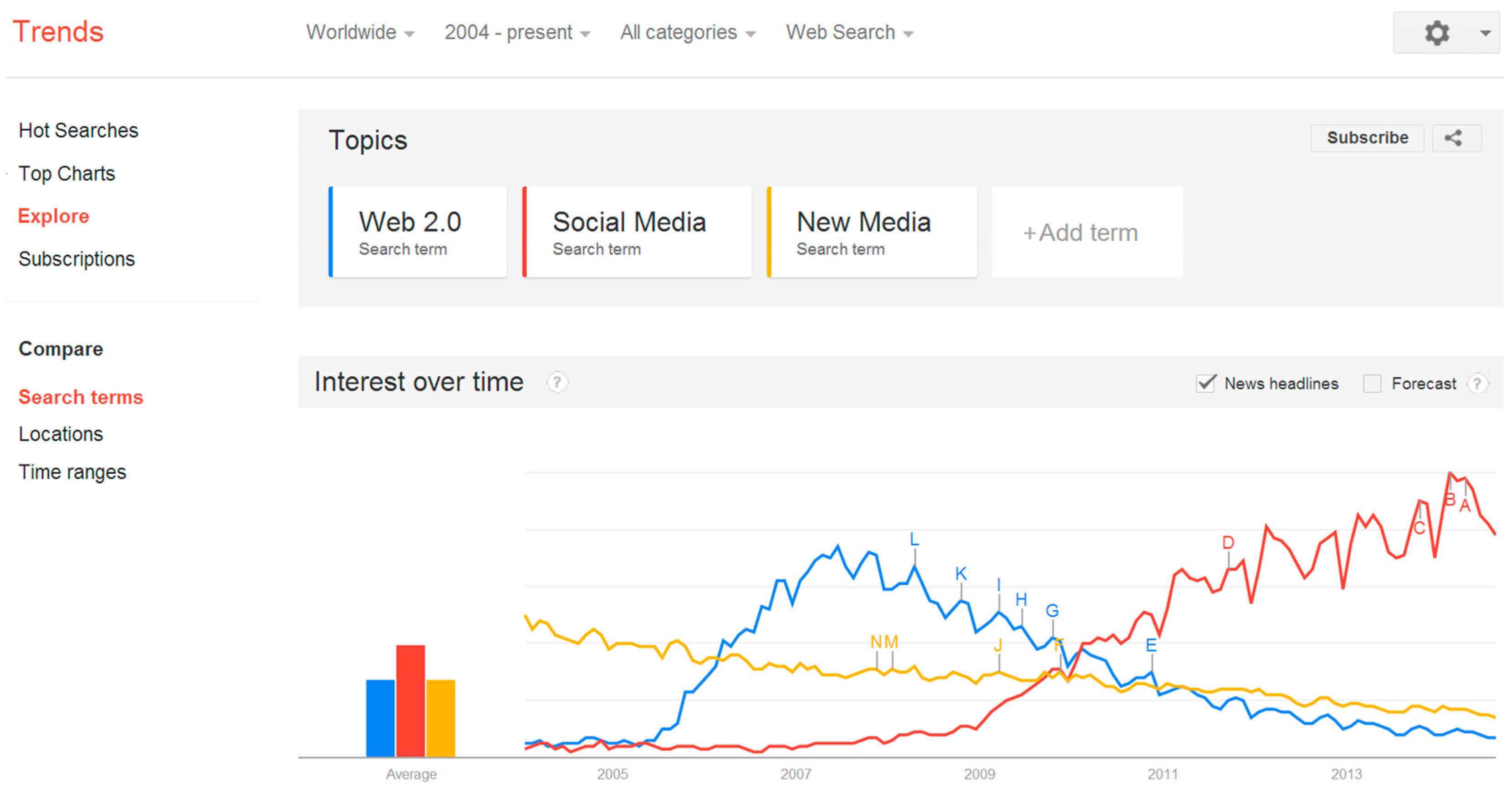
Figure 1 ([
87]) below, following Kaplan and Haenlein [
86] it is considered that this term only refers to a particular outcome of Web 2.0, and is often narrowly discussed with reference to the dominant popular platforms. The term Emergent Media captures important overall characteristics of Web 2.0 that deserve further adoption, but it is just not widely recognised.
Figure 1.
Google Trends [
87] search for the terms Web 2.0 (blue), social media (red) and new media (yellow). It shows searches for social media begin rising later than Web 2.0, eventually overtaking it around 2010, while the usage of new media originates before Web 2.0, and has progressively declined.
In many ways these examples exhibit openness and interactivity, but whether this results in Macnamara’s [
17] “creativity, diversity and plurality of content” is more difficult to assess. Often the information that can be volunteered is strictly controlled, with limited options for free text and user generated naming or tagging. This is not surprising: allowing volunteers to tag species with their own names, generating folksonomies, would wreak havoc with the well-established classification system of plant and animal taxonomy. In these cases this sort of openness is considered antithetical to the purpose, but crowdsourcing and enlisting citizens as sensors to VGI can still be implemented. However, creativity, diversity and plurality of content can be considered to occur, such as through allowing collaboration in developing open source software, but it is within a particular subject matter and discipline domain, with the role of the citizens and crowds primarily as suppliers of data and perhaps information, with limited roles in the creation of resultant knowledge or even wisdom. It is possible to view this approach as mainly aimed at increasing the efficiency of existing scientific disciplines and approaches. The role of users is broadened however, where sites integrate with other Social Media, such as Redmap’s use of Facebook, in which freer, more open dialogues, conversations and community building can occur. Assessments of degrees of interactivity and openness become increasingly difficult as such integration blurs the boundaries between platforms.
Notable though is the focus of many of these sites’ on limited subject matter, often single physical environmental phenomenon: other examples include FeralScan [
88], for managing feral animals, the North Australian Fire Information (NAFI) [
89], about fire in the north of Australia and Birdata [
90], crowdsourcing information relating to birds. Environmental sustainability involves the management of many phenomena, often acting together in complex ways such that for example an environmental manager would be interested in how fire may be interacting with biodiversity and feral animals; hence would require some way of integrating information from NAFI, FeralScan and the ALA. As such these sites require that the person who volunteers their information to these sites structures it on the sites’ terms. If a person contributes to multiple sites, their information is then fragmented across multiple databases. As identified by Elwood [
26], this raises questions whether such sites produce unequal power relationships between site creators and the volunteers of information: not all architectures of participation are equal, or produce equal relationships.
Managing such phenomenon also requires the consideration and generation of a vast range of information relating to values, plans, actions, audits and monitoring. Relevant environmental information crosses many subjects, relates to and is produced by the management cycle, and crosses geographical, sectorial and institutional domains. Also, when we consider the entwining of environmental concerns with social and economic issues, the boundary for relevancy extends outwards yet further. Who decides what constitutes relevant or priority environmental information is apposite for questions regarding investment in such initiatives and how they should be then structured. Many of the above platforms have been in existence for several years and emanate from established institutions, either government or research, with credentials as authorities and substantial control over relevant information. The design of many shows the site creator’s priorities are mostly about increasing the efficiency of existing practice. It is then interesting to see that alternative requirements are being explored in other Australian applications.
At a state level, the Victorian Government created wePlan [
91] to harness community input into planning for the State’s Parks. While the public Website doesn’t incorporate an interactive geospatial component, it is used “behind the scenes” for gathering select community input into landscape values [
92]. The design of this initiative is informed by the discipline of Public Participation GIS (PPGIS) for which the topics of crowdsourcing, volunteering geographic information and citizens acting as sensors should be of interest. However, there is little overlap in the literature cited by Brown and Weber (op cit.), or DeFreitas [
93], in a study of the role of public participation, spatial information and GIS in natural resource management of the dry tropical coast, with that relating to crowdsourcing or VGI. This aligns with Haklay’s [
51] observation of “a fundamental difference between the literature about Neogeography and that of critical GIS and PPGIS” with “the former mostly supporting the instrumentalist view of technology, (while) the latter is well within the critical perspective of technology” (p. 60). This indicates a deeper engagement with the ontological perspectives of platform creators would provide insights into the implications of the respective architectures of participation.
Two other public access examples are the Connecting Country Community Web Mapping portal [
94], and Placestories’ Digital Landcare [
95], both collaborative initiatives between community, government and private enterprise. Connecting Country provides a platform “where individuals and community groups can view, create and share information about their local landscape”. Placestories is an integrated platform that is even more broadly defined yet is inclusive of environmental management initiatives, being used by Landcare groups in a context that integrates wider social concerns. These sites are less controlled in ways that the above are not, allowing free text descriptions and a range of different forms of information to be added by attaching documents and other media, such that information about management actions can be communicated.
If the transformative or disruptive power of an open and interactive internet also arises from the inclusion of alternative views, allowing the bypassing of traditional controls, where authority is asserted and reinforced by recognition from the wider community, then of significance in early 2012, was the emergence of two community based initiatives. These were Local Harvest [
96], about local food and sustainable food production, and Getup’s Coal Seam Gas Map [
97], for people concerned about Coal Seam Gas mining. There are no well-developed ontologies or methodological disciplines for local sustainable food production, or for protesting against Coal Seam Gas mining, so another architecture of participation has been developed to accommodate differences in content and modes of expression. An open GeoWeb 2.0 allows multiple architectures of participation for these sites to deal with environmental information that established institutions do not or will not.
Overall, since early 2005 use of the GeoWeb 2.0 in Australia has proliferated to support crowdsourcing, citizens acting as sensors and the volunteering of geographic information for a broad range of environmental applications. The developments outlined above signal a spreading awareness about the GeoWeb 2.0, together with its maturation towards lower barriers to wider use. With continued searching it is possible to find applications across most environmental subject matter, geographic areas, and social groupings, including implementations from community groups, small businesses, and individuals, as the GeoWeb 2.0 provides the means for people to communicate to their peers on issues important to them and in ways that are meaningful to them. This is the long-tail of the internet that Anderson [
21] and O’Reilly [
3] emphasised, relevant to environmental sustainability. Such groups and individuals are using aspects of the GeoWeb 2.0 that are not provided by the established institutional offerings, supporting citizens acting as sensors and volunteering geographical information to pursue their objectives, not just data about the physical environment, but also about issues and impacts, values, actions and solutions, effectively crowdsourcing a broad range of environmental data, information, knowledge and wisdom relevant to sustainability.
4. Where 2.0 Australia’s Environment?
There is a great deal of inter-site variability in the way the GeoWeb 2.0 is being implemented across environmental applications in Australia. What is informing this use and perhaps more importantly, whether such use is likely to be beneficially transformative or otherwise disruptive, as has been observed elsewhere, is difficult to ascertain. The factors that constitute the GeoWeb 2.0 are variously and imprecisely described across the literature, and include a mix of social and technological characteristics. There is little disagreement that interactivity that allows two way communications is a central feature, with some discourses extending this to include openness, with an important consequence of this being its support for creativity, diversity and plurality of content. The extent to and manner in which interactivity and openness is being implemented, to support creativity, diversity and plurality of content, requires methodologies for assessing degrees of implementation and the relative merits of different approaches. Similar issues regarding open access publishing have been approached through the proposition of an open index [
98]. Even given suitable methodologies, making assessments is problematic as integration between separate sites presents difficulties in drawing boundaries. This suggests that it is necessary to take a wider view, across multiple sites to assess whether the level of openness and interactivity fosters creativity, diversity and plurality of content.
No one site or platform implements all of characteristics of Web 2.0, (that is, are open or interactive in all possible ways); however it is possible to consider that collectively they do. Therefore assessments of how well the internet supports creativity, diversity and plurality of content, are usefully done at multiple levels. Holistic assessments are however probably unachievable given the internet extends out almost boundlessly and is in a constant state of flux. Difficult questions for academics, industry and government are then deciding where and how to draw boundaries, and what the indicators are of sufficient openness and interactivity of the right kind, to support desired outcome? Governments can both build particular applications or platforms, such as ALA, and support the community in sharing relevant information using existing online applications and resources. Initiatives such as GovHack [
99], the Landcare Social Media manual and Webinar [
100], and social media workshops associated with the National Broadband Network Digital Futures program, are evidence of the latter approach in action now. Innovative solutions can emerge: Local Harvest was initially partly resourced by crowdfunding [
101].
It raises questions about whether conceptualising and addressing issues at broader scales of time and place, historically the provenance of institutions, are best done through the creation of separate platforms from those freely available, or is it best to place no limits, foster openness and harvest or mine the resultant data flood. For example, without a Redmap platform, could relevant information be harvested from social media or recreational fishing and diving internet sites, as is being explored by Connors
et al. [
30] and Stefanidis
et al. [
59]? Could a state of the environment “report” be generated from the long tail of the GeoWeb 2.0 sites created as the general community addresses environmental management issues how they see fit, through businesses, not-for profit and voluntary initiatives, conceptualising issues and solutions creatively, pluralistically? The role of the geospatial industry and government becomes then not only to create platforms, but to provide tools, places, resources, expertise and guidance for the wider community, not for a predetermined outcome, but to foster diversity, creativity and plurality. Such a loosening of control in turn raises many other issues, including equity of access, representation, relevance, discovery, quality assurance, authority, privacy and security. How are views at broader scales of time and space to be generated if the information so produced is predominantly heterogeneous, introducing major problems of semantic mediation? Not filtering makes semantic mediation very difficult, but any pre-filtering of information is a simplification that introduces uncertainty, but all information architectures embody different world views and types of uncertainty. Is it still relevant to pursue all views at broader scales to inform top-down strategies, if environmental issues can be addressed from the bottom-up, through self-organisation, peer-to-peer connections, and crowdsourcing? There are many questions that these practices raise.
5. Conclusions
There is substantial evidence in the form of online applications that the Australian community is well advanced in using the GeoWeb 2.0 for crowdsourcing, and engaging citizens acting as sensors to volunteer geographic information relevant to environmental management and sustainability. This use is by government and research institutions, not for profit, advocacy and other community organisations, and individuals and appears to be placing environmental sustainability in Australians collective hands. If so, an understanding of where this may lead is essential, as experience in other subject matter domains has shown the potential for beneficial transformation, disruption and undesirable outcomes. Ideally we receive a contribution to this understanding from academic debate and research. However, relative to internationally, Australian academic research into the topics of crowdsourcing, citizens as sensors and VGI is only just beginning. Crowdsourcing has only recently appeared in the research agenda of the Co-operative Research Centre for Spatial Information (CRC-SI) [
102], with an emphasis and primary interest on how crowdsourced information can be integrated with authoritative spatial data infrastructures. Existing relevant Australian research into these topics and the conditions that foster various manifestations is also occurring in other disciplines and under different conceptualisations. These separate discourses mediate against a holistic view, with each knowledge silo not considering the full implications of such developments acting together and synergistically.
Whether or how such literature is informing Australian environmental applications is also difficult to ascertain. Few of the applications publish the rationale for their design decisions, and of those that are published, for example ALA, there is little reference to the literature describing the GeoWeb 2.0. While there is a substantial research literature emanating from North America and Europe, given that the GeoWeb 2.0 is constituted by both social and technological factors, the transferability of this international research to the Australian context requires a careful assessment. This paper has contributed to this assessment by providing an outline of relevant literature, in the context of Australian examples for environmental sustainability.
Future research would usefully be directed at classifying GeoWeb 2.0 activities into descriptive typologies. Such research may then provide insights into the transformative or disruptive potential of not only Australian developments for environmental sustainability, but also broader applications. Measures of openness could be derived from a classification of the extent to which activities incorporate GeoWeb2 features, such as API’s, folksonomy or creative commons licensing. Such a classification may also contribute to understanding the relationship between particular architectures of participation and the ontological viewpoint(s) of the platform creators. Additional classification criteria are the skill base of users, geographic context or the availability of ICT technologies.
Creating such classifications would need to address substantial issues. Firstly, little is yet published by the creators of such platforms making the discovery of such factors largely reliant on secondary sources or specific targeted research. Secondly, the increasingly networked and interconnected nature of these activities presents difficulties for drawing boundaries between categorisations. Lastly, Web 2.0, and by extension GeoWeb 2.0, are phenomena that are not described consistently across the literature, as shown by the diversity of terminology used, disciplinary approaches and literature cited by many authors.
